
Document 207161
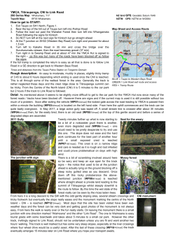
How To Setup GPS on GTM382
Configuration Manual
Option nv, Gaston Geenslaan 14, 3001 Leuven - Belgium - Tel +32 16 317 411 - Fax +32 16 207 164
How To Setup GPS on GTM382,
Configuration Manual
About this document
Overview and Purpose
This document explains how to use the different variants of GPS on Option GTM382 module,
and provides help to setup S-GPS, A-GPS using SUPL servers and gpsOneXTRA.
It also explains which parameters are needed to setup the customization process of a module
in production.
Confidentiality
All data and information contained or disclosed by this document is confidential and
proprietary of Option NV, and all rights therein are expressly reserved. By accepting this
document, the recipient agrees that this information is held in confidence and in trust and will
not be used, copied, reproduced in whole or in part, nor its contents revealed in any manner
to others without prior and written permission of Option NV.
Version History
Date
Version
Author
Apr 10, 2009
Apr 17, 2009
V001draft
V001int
D. Callaert
D. Callaert
Apr 27, 2009
V002int
D. Callaert
May 20, 2009
V002ext
J. Boeckx
July 07, 2009
V003int
J.Boeckx
July 07, 2009
V003ext
J.Boeckx
Revision
F. Bilsen
J. Boeckx
F.Bilsen
Remarks
Initial version
Review
Added installation and general
configuration info
Made public for external use
Change to figure 2-1: antenna
location
Removed Part 6 OneXtra
Added at_ogclk information for
assisted GPS
Added changes for CCLK and
OGCLK.
References
Ref
[1]
Author:
Creation Date:
Option
Confidential:
Document
PIC-SYE-TN-GPS_AT_Command_Reference_(external_use)-v0xxdraft.pdf
Version:
J. Boeckx
V003ext
1 of 11
Page:
July 7, 2009
This document is Option Confidential - it may not be duplicated, neither distributed externally
without prior and written permission of Option NV.
How To Setup GPS on GTM382,
Configuration Manual
Table of contents
1
2
3
4
5
INTRODUCTION .............................................................................................................. 3
1.1
Supported GPS Modes.............................................................................................. 3
1.2
GPS and Rx Diversity Functionality........................................................................... 3
MODULE INSTALLATION and GPS CONFIGURATION................................................. 4
2.1
Prerequisites.............................................................................................................. 4
2.2
Hardware setup ......................................................................................................... 4
2.3
Connecting to the application interface ..................................................................... 5
2.4
Activate the GPS interface ........................................................................................ 6
2.5
Getting GPS information............................................................................................ 7
General GPS Information.................................................................................................. 8
3.1
TTFF .......................................................................................................................... 8
3.2
Ephemeris – Almanac data ....................................................................................... 8
3.3
Expiry of Assistance data .......................................................................................... 8
3.4
MS-Based and MS-Assisted A-GPS ......................................................................... 8
3.5
NMEA Data................................................................................................................ 8
Standalone GPS ............................................................................................................... 9
4.1
Introduction ................................................................................................................ 9
4.2
Make a single fix ........................................................................................................ 9
4.3
Make a Continuous fix ............................................................................................... 9
Assisted GPS .................................................................................................................. 10
5.1
Introduction .............................................................................................................. 10
5.2
Using a non-secure SUPL server ............................................................................ 10
5.2.1
Setup for testing purpose................................................................................. 10
5.2.2
Setup for commercial use ................................................................................ 11
5.3
Using a secure SUPL server ................................................................................... 11
Author:
Creation Date:
Option
Confidential:
Version:
J. Boeckx
V003ext
2 of 11
Page:
July 7, 2009
This document is Option Confidential - it may not be duplicated, neither distributed externally
without prior and written permission of Option NV.
How To Setup GPS on GTM382,
Configuration Manual
1
INTRODUCTION
The Option GTM382 embedded module provides connection to the internet using
GPRS/EGPRS/UMTS/HSDPA/HSUPA technology. It also provides GPS functionality.
In order to configure the GPS functionality, Option proprietary AT commands have been developed
for testing purpose. More information can be found in ref [1]. When using the device in a production
environment, certain GPS parameters are needed to setup the customization process of the
module.
The most important frequency used for GPS is located in the L1 band (1575.42 MHz).
This document will explain how to setup/use the following different possibilities for GPS: it will
explain setup of S-GPS (standalone GPS), MS-Based A-GPS (Assisted GPS using a SUPL
server) and gpsOneXTRA, the GPS service using a standard Qualcomm service.
If your device is not yet installed and/or GPS functionality is not yet enabled, the chapter 2 will
explain how to do this.
1.1
Supported GPS Modes
The following modes of operation are supported by the device:
• Standalone GPS
• UE-Assisted GPS
• UE-Based GPS
• gpsOneXTRA
The following protocols are supported:
• OMA SUPL 1.0 UP
• GSM CP (Rel 5)
• UMTS CP (Rel 5)
1.2
GPS and Rx Diversity Functionality
The receiver diversity antenna signal (RxDiv) and GPS cannot be used simultaneously as
they are using the same physical antenna connection point. Therefore, using GPS on the
GTM module will result in deactivation of the RxDiv signal.
The GTM module can however switch between both modes, meaning when GPS is switched
on, the Rx Diversity capability is switched off and vice versa. Re-enabling Rx Diversity after
switching off GPS can however take a few seconds.
The secondary antenna, used for the reception of RxDiv and GPS signalling, must be
designed to support the both GPS and RxDiv band frequencies.
Author:
Creation Date:
Option
Confidential:
Version:
J. Boeckx
V003ext
3 of 11
Page:
July 7, 2009
This document is Option Confidential - it may not be duplicated, neither distributed externally
without prior and written permission of Option NV.
How To Setup GPS on GTM382,
Configuration Manual
2
MODULE INSTALLATION AND GPS CONFIGURATION
This section will explain the steps on how to configure the GTM382 module so the GPS
connections are setup correctly and the device drivers are installed.
2.1
Prerequisites
It is assumed that following conditions are fulfilled:
• The GTM382 module is configured and working for normal data connections (2G/3G),
meaning all necessary drivers for the data connections are correctly installed and
working
• A driver package (5.x.y.z) is loaded onto your system
• On a GTM382 module, v1.x firmware 1.9.0.0 (or higher) or v2.x firmware 2.6.0.0 (or
higher) is recommended.
You have a working GPS antenna that you have connected to the module. For active GPS
antennas, the power needs to be supplied externally.
Perform initial tests outside, in a clear area that has very good reception of the GPS satellite
signals.
2.2
Hardware setup
Make sure your module is connected to your PC as described in the Option Quick Start Guide
that was delivered with the module. Make sure you have tested your setup and that it’s
working.
Connect a GPS antenna to the auxiliary antenna connector of the module, which is marked
by the letter “A” on the PCB (shown in the circle in Figure 2-1).
Figure 2-1: auxiliary antenna position
Author:
Creation Date:
Option
Confidential:
Version:
J. Boeckx
V003ext
4 of 11
Page:
July 7, 2009
This document is Option Confidential - it may not be duplicated, neither distributed externally
without prior and written permission of Option NV.
How To Setup GPS on GTM382,
Configuration Manual
2.3
Connecting to the application interface
Open the Windows Device Manager and determine the COM port number for the module’s
application interface.
Check the properties of the Globetrotter Module HSxPA USB device to see which drivers are
loaded. Verify that the driver is the correct version (see above).
If a GPS interface is already shown in the device manager, section 2.4 can be skipped.
Figure 2-2: Application interface of the Globetrotter module in Device Manager
Open a terminal program (like HyperTerminal) and connect to the application interface
(COM3 in the above example but will probably be a different COM port on your system).
To verify the setup, you can type ATI in the HyperTerminal. The Globetrotter module will
reply with its identification string.
Figure 2-3: Globetrotter identification string
Along with the model number, the firmware version is displayed. Verify that your module’s
firmware corresponds with the minimum recommended version.
Author:
Creation Date:
Option
Confidential:
Version:
J. Boeckx
V003ext
5 of 11
Page:
July 7, 2009
This document is Option Confidential - it may not be duplicated, neither distributed externally
without prior and written permission of Option NV.
How To Setup GPS on GTM382,
Configuration Manual
2.4
Activate the GPS interface
The GPS and other interfaces can be turned on and off using the AT command AT_OIFACE.
This command is an Option proprietary command and should not be communicated to the
end-customers. This chapter will only explain how to enable/disable the GPS interface.
AT_OIFACE? displays the current status of the module’s interface configuration.
For example:
AT_OIFACE?
DIAG: 1
GPS: 0
APP1: 1
APP2: 0
PCSC: 0
IP: 1
MODEM: 1
VOICE: 0
SD: 1
CD: 0
OK
The part GPS: 0 in the response above shows that the GPS device is disabled.
•
•
To enable the GPS interface, issue the following AT command:
AT_OIFACE=”GPS”,1
A module reboot is needed to configure the GPS interfaces of the module correctly.
To disable the GPS interface afterwards, issue the following AT command:
AT_OIFACE=”GPS”,0
Again a module reboot is needed for the changes to take effect.
As indicated, the Globetrotter module needs to be rebooted for the GPS ports to become
available. Unplug the power supply and USB connection to do this. After powering up again,
the GPS interfaces will become available in the Windows device manager:
Figure 2-4: GPS interfaces becomes visible in Device Manager
When the module is powered up, 2 extra interfaces will become available:
• GPS Control Interface
This interface can be used as an AT command port to configure GPS parameters
• GPS Data Interface
This interface will show the NMEA data
Author:
Creation Date:
Option
Confidential:
Version:
J. Boeckx
V003ext
6 of 11
Page:
July 7, 2009
This document is Option Confidential - it may not be duplicated, neither distributed externally
without prior and written permission of Option NV.
How To Setup GPS on GTM382,
Configuration Manual
2.5
Getting GPS information
The GPS Data interface is a serial port to the module, so you can connect to it with a terminal
program. The interface cannot be used for entering AT commands, but the GPS output
(NMEA data) will appear on it.
GPS position determination is started using the AT_OGPS command. This will be explained
the chapters about S-GPS, A-GPS and gpsOneXTRA.
When there is a sufficiently strong GPS signal, an NMEA data stream will appear on the GPS
Data interface. Initially, the module will continuously receive satellite data. The position data
will be empty at this time. After a while, the module will get a position fix and display it in the
$GPGGA value.
Figure 2-5: NMEA data before position fix
Figure 2-6: NMEA data with position fixed
Author:
Creation Date:
Option
Confidential:
Version:
J. Boeckx
V003ext
7 of 11
Page:
July 7, 2009
This document is Option Confidential - it may not be duplicated, neither distributed externally
without prior and written permission of Option NV.
How To Setup GPS on GTM382,
Configuration Manual
3
3.1
GENERAL GPS INFORMATION
TTFF
Time To First Fix (TTFF) is a specification detailing the time required for a GPS receiver to
acquire satellite signals and navigation data, and calculate a position solution (fix).
The time to first fix can be depending on the state of the GPS receiver, meaning if the
receiver already has information of previous fixes or not. This can be divided in 3 scenarios:
Cold start Condition
No position data is stored in the UE or the data is inacurate. Ephemeris, ionosphere,
reference time and position assistance data have been deleted or are not present. In cold
start condition, also almanac data can be present.
The TTFF will be around 40 sec.
Warm start Condition
UE has all data except time.
TTFF is shorter than in cold condition (the value depends on the environment you are in)
Hot start Condition
All the date is stored in the UE, therefore
TTFF will be the shortest in this condition (the value depends on the environment you are in).
3.2
Ephemeris – Almanac data
Each satellite continuously transmits messages containing the time the message was sent,
precise orbital information (ephemeris data) and the general system health and rough orbits
of all GPS satellites (almanac data).
3.3
Expiry of Assistance data
It will take 2 hours for ephemeris data to expire. This will cause a warm start to change into a
cold start. Almanac data will expire after 6 months.
3.4
MS-Based and MS-Assisted A-GPS
In MS-Based mode, the network provides the satellite information to the device, based on a
rough estimate of where the device is located, and the device acquires the GPS signals from
the satellites and calculates its location. After the initial fix, the device operates like an
autonomous GPS receiver until the satellite information must be refreshed. At this time the
device goes back to the network to update the satellite information. MS-Based mode is
appropriate for applications that require the device location to be updated rapidly.
In MS-Assisted mode, the network elements (for example base station, …) calculate the
location of the device. This mode is suitable for one-shot fixes, wherein the location does not
need to be updated frequently.
3.5
NMEA Data
The module supports the following sentences of the NMEA protocol:
• GGA: fix information
• GSA: overall satellite data
• GSV: detailed satellite data
• RMC: recommended minimum data for GPS
• VTG: vector track and speed over the ground
Author:
Creation Date:
Option
Confidential:
Version:
J. Boeckx
V003ext
8 of 11
Page:
July 7, 2009
This document is Option Confidential - it may not be duplicated, neither distributed externally
without prior and written permission of Option NV.
How To Setup GPS on GTM382,
Configuration Manual
4
4.1
STANDALONE GPS
Introduction
Standalone GPS means that the device can function on its own without for example
assistance data from a server. The module demodulates the position data directly from GPS
satellites in its ‘line of sight’. The disadvantage of S-GPS is reduced cold-start sensitivity as
the TTFF (time to first fix) will take longer than asissted gps systems as no assisted data is
used and position is only calculated with the information received by satellites.
Not much is needed to setup S-GPS on the module.
To enable the S-GPS function, the following at commands can be used (refer to [1] for more
info):
• AT_OGPSP
• AT_OGPS
AT_OGPSP is used to set the correct parameters that need to be used. By default, the setting
for this command will be ok for S-GPS and you do not need to change the parameters.
In case you want to switch from assisted GPS settings to standalone GPS, the following at
command needs to be used:
AT_OGPSP=7,1
This commands makes sure position, velocity and height are calculated and S-GPS service is
selected.
4.2
Make a single fix
Entering AT_OGPS=1 will start the GPS engine and will make a single fix. After this fix, the
GPS engine stops.
4.3
Make a Continuous fix
Entering AT_OGPS=2 will start the GPS engine and will restart it when it turns off. This will
usually generate a fix every second until the GPS engine gets disabled by using AT_OGPS=0
Author:
Creation Date:
Option
Confidential:
Version:
J. Boeckx
V003ext
9 of 11
Page:
July 7, 2009
This document is Option Confidential - it may not be duplicated, neither distributed externally
without prior and written permission of Option NV.
How To Setup GPS on GTM382,
Configuration Manual
5
ASSISTED GPS
5.1
Introduction
A-GPS uses assistance data to get faster to a first fix (faster TTFF).
In most cases, this data is received using an internet/data connection.
This chapter will explain how to setup the module, for testing purposes, using MS-Based
assistance data from a SUPL server. It will not explain how to setup GSM CP and UMTS CP.
There are two different configurations for connecting to a SUPL server, depending if using a
secured or a non-secured SUPL server.
5.2
Using a non-secure SUPL server
In case of using a non-secure SUPL server, several parameters need to be configured on the
module.
For testing purposes, Option confidential AT commands can be used.
For commercial use, several parameters need to be set through an Option customization
process:
• Network APN – Operator dependent
• SUPL server IP address or URL and Port Number
• Current Time and Date
5.2.1
Setup for testing purpose
To setup assisted GPS using a non-secure SUPL server, the following AT commands can be
used for testing reference:
• Setting the GPS mode to MS Based A-GPS:
AT_OGPSP=7,2
• Setting the PDP context parameters:
AT_OGPSCONT=1,”IP”,”myAPN”
AT_OGPSPDPP should be used when authentication for PDP activation is needed
• Setting the SUPL server:
AT_OGPSLS=1, “http://www.yourSUPLurl.com:7275”
This at command can be used to set the URL and port number of the SUPL server.
• Setting the time:
AT_OGCLK=”yy/MM/dd,hh:mm:ss±zz”
This at command can be used to set the current time, date and time zone.
Until FW 2.9.1.0, AT_OGCLK was NOT available and AT+CCLK should be used:
AT+CCLK=”yy/MM/dd,hh:mm:ss” to set the current time and date.
As the Option module has no clock information (or battery to store clock information after
shutdown), please keep in mind that the time has to be set after every power on! This time
is necessary to decide if a refresh of the assistance data is needed or not.
To start the GPS fix, enter AT_OGPS=2 (continous fix).
Author:
Creation Date:
Option
Confidential:
Version:
J. Boeckx
V003ext
10 of 11
Page:
July 7, 2009
This document is Option Confidential - it may not be duplicated, neither distributed externally
without prior and written permission of Option NV.
How To Setup GPS on GTM382,
Configuration Manual
5.2.2
Setup for commercial use
Option will customize the module based on the customer’s input for the following parameters
• Requested GPS type:
o Standalone
o A-GPS using secure SUPL
o A-GPS using non-secure SUPL
o gspOneXTRA
• SUPL server’s URL and Port Number
• Current Time and Date
• Network APN – If available
The network APN parameter will change for different operators. This means in case a
device will be distributed by one customer to different operators, this parameter cannot be
part of customization, and need to be set by for example a software application that will
set the APN depending on the SIM inserted.
5.3
Using a secure SUPL server
In case of using a secure SUPL server, several configurations need to be done on the
module, and some can only be done during the Option customization (factory) process of the
module, and not by the end-user or laptop/MID manufacturer.
This means for setting up A-GPS using a secure SUPL server with the Option device, please
check with your Option contact for a customized device.
The following parameters need to be setup for use with a secured SUPL server:
• Security parameters setting: Option Internal customization
• SUPL certificate to be stored on UE: Option Internal customization
• Setting the GPS mode to MS Based A-GPS: done by entering AT_OGPSP
• Setting the PDP context parameters: done by entering AT_OGPSCONT,
AT_OGPSPDPP
• Setting the time: done by entering AT_OGCLK (or for FW versions before 2.9.1.0,
AT+CCLK should be used)
• Setting the SUPL server’s address: done by entering AT_OGPSLS
• Start the GPS engine: done by entering AT_OGPS
To setup the device with a secured SUPL server, the device needs to be configured by
Option to setup the security specific parameters and certificates.
After the device has been customized (with SUPL server URL, security certificate,…), several
parameters need to be entered by the software application (or by AT commands). The
following parameters need to be set:
• Current Time and Date – needed to check validity of the assistance data
• Network APN – If available
• Start/Stop of GPS engine (AT_OGPS)
Author:
Creation Date:
Option
Confidential:
Version:
J. Boeckx
V003ext
11 of 11
Page:
July 7, 2009
This document is Option Confidential - it may not be duplicated, neither distributed externally
without prior and written permission of Option NV.


© Copyright 2026