
OOI RF A Cover Sheet X Ridge
OOI RF A Cover Sheet
LOI
Full
X
Addendum
Above For Office Use Only
Please fill out requested information in all gra y boxes
Title:
Proponent(s):
A NorthEast Pacific Hydrate Observatory System (NEPHOS) at South Hydrate
Ridge
Kevin Brown, Robert Collier, Gary Klinkhammer, Ian MacDonald, Kate Moran,
Charlie Paull, Adam Schultz, Marta Torres, Anne Trehu
Keywords:
(5 or less) gas hydrates, methane flux, fluid flow
Area:
continental
margin off OR
Contact Information:
Contact Person:
Department:
Organization:
Address
Tel.:
E-mail:
Anne Trehu
COAS
Oregon State University
Ocean Admin Bld 104, Corvallis OR 97331-5503
Fax: 541-737-2064
541-737-2655
[email protected]
Permission to post abstract on ORION Web site:
x
Yes
No
Abstract: (400 words or less)
We propose an observatory designed to characterize the geophysical, hydrological, chemical and biological processes that drive temporal and spatial variability in the methane-rich environment of South Hydrate
Ridge (SHR) in the accretionary complex of the Cascadia subduction zone. The distribution of gas hydrate in SHR is well constrained; however, the dynamic processes that control methane transport and hydrate formationare not well understood. In addition, a full inventory of methane seepage and its impact
on carbon cycling is not yet available.
Hydrate Ridge is subject to a variety of transient tectonic and oceanographic forcing factors that
vary on time scales that can be monitored with subseafloor instrumentation coupled with seafloor and
water column installations. Our long-term goal is to unravel the interrelationships among tectonic, oceanographic and biologic processes in a system in which gas hydrates constitute an important component of
the carbon reservoir. We will accomplish this goal through the development of a multidisciplinary NorthEast Pacific Hydrate Observatory System (NEPHOS), designed to facilitate and encourage simultaneous
acquisition of correlative data from deep within the sediment to the water column. Our concept builds on
results collected during more than 20 years of research in this area. Currently there are a variety of efforts
underway to bring the NEPHOS concept to fruition. These include: 1) an IODP drilling proposal to install
large-scale borehole observatories in this region; 2) a proposal to NSF to develop and test a new type of
subseafloor observing system (SCIMPI); 3) a proposal to NSF to install mini boreholes to characterize the
shallow hydrology of the system; 4) Significant investment from NASA for modular fluid and in situ
sampling capabilities, including a pending NASA proposal to further develop and test the equipment at
HR, Several other instrument design proposals are in the planning stage and will be submitted soon.
Broader impacts: Implementation of NEPHOS impacts outreach and education, future hydrocarbon resource evaluations, and astrobiology. We will take advantage of the public’s fascination with “burning
ice” to strengthen ongoing and planned outreach efforts. Many of the experimental protocols developed to
sample and characterize subseafloor microbes are applicable to exploration for life elsewhere in the solar
system. Knowledge of the temporal evolution of this focused gas hydrate deposit is needed to quantify
the resource potential of gas hydrates.
Please describe below key non-standard measurement technology needed to achieve the proposed
scientific objectives: (250 words or less)
SCIMPI (sensor strings to be deployed in closed boreholes by IODP)
CORKS (sensors and samplers to be deployed in boreholes by IODP)
mini-CORKS (3-5 meter-long borehole fluid samples)
multifrequency acoustic bubble monitor
Proposed Sites:
Site Name
SHR1
SHR2
SHR3
Position
Water
Depth
(m)
Start
Date
44.577N 125.150W 845 1/1/07
44.568N 125.150W 807 1/1/07
44.570N 125.147W 788 1/1/07
Proposed Duration
Revisits
Deploy
during
(months)
deployment
Site-specific Comments
All sites ~50 km from
Newport OR; close to
other proposed observatories.
List of Project Participants
Kevin Brown (SIO), Bill Chadwick (OSU/NOAA), Robert Collier (OSU), Rick Colwell (INEL),
Gary Klinkhammer (OSU), Ian MacDonald (TAMU-CC), Kate Moran (URI),
Charlie Paull (MBARI), Adam Schultz (OSU), Marta Torres (OSU), Anne Trehu (OSU)
Suggested Reviewers
Gerhard Bohrmann (Un. of Bremen, [email protected])
Scott Dallimore (Canadian Geological Survey, [email protected])
Jerry Dickens (Rice Un., [email protected])
Debra Hutchinson (U.S. Geological Survey, [email protected])
Ingo Pecher (Institute of Geological and Nuclear Science, New Zealand, [email protected])
Harry Roberts (Louisiana State Un., [email protected])
Dendy Sloan (Colorado School of Mines, [email protected])
Erwin Suess (GEOMAR, [email protected])
ABSTRACT
We propose an observatory designed to characterize the geophysical, hydrological, chemical
and biological processes that drive temporal and spatial variability in the methane-rich
environment of south Hydrate Ridge (SHR) in the accretionary complex of the Cascadia
subduction zone. The distribution of gas hydrate in SHR is well constrained; however, the
dynamic processes that control methane transport and hydrate formation are not well understood.
In addition, a full inventory of methane seepage and its impact on carbon cycling is not yet
available.
Hydrate Ridge is subject to a variety of transient tectonic and oceanographic forcing factors
that vary on time scales that can be monitored with subseafloor instrumentation coupled with
seafloor and water column installations. Our long-term goal is to unravel the interrelationships
among tectonic, oceanographic and biologic processes in a system in which gas hydrates
constitute an important component of the carbon reservoir. We will accomplish this goal
through the development of a multidisciplinary NorthEast Pacific Hydrate Observatory System
(NEPHOS), designed to facilitate and encourage simultaneous acquisition of correlative data
from deep within the sediment to the water column. Our concept builds on results collected
during more than 20 years of research in this area. Currently there are a variety of efforts
underway to bring the NEPHOS concept to fruition. These include: 1) an IODP drilling proposal
to install large-scale borehole observatories in this region; 2) a proposal to NSF to develop and
test a new type of sub-seafloor observing system (SCIMPI); 3) a proposal to NSF to install mini
boreholes to characterize the shallow hydrology of the system; 4) significant investment from
NASA for modular fluid and in situ sampling capabilities, including a pending NASA proposal
to further develop and test the equipment at HR. Several other instrument design proposals are
in the planning stage and will be submitted soon.
Broader impacts: Implementation of NEPHOS impacts outreach and education, future
hydrocarbon resource evaluations, and astrobiology. We will take advantage of the public’s
fascination with “burning ice” to strengthen ongoing and planned outreach efforts. Many of the
experimental protocols developed to sample and characterize subseafloor microbes are
applicable to exploration for life elsewhere in the solar system. Knowledge of the temporal
1
evolution of this focused gas hydrate deposit is needed to quantify the resource potential of gas
hydrates.
PREFACE
This proposal reflects the confluence of many efforts to understand the role of gas hydrates
on the carbon cycle in a coastal region. Previous, ongoing, planned and proposed experiments in
this area address various aspects of this problem. Integration of these programs constitutes the
backbone of the proposed NorthEast Pacific Hydrate Observatory System (NEPHOS)
observatory, which hinges, for its full implementation, on the availability of power and telemetry
capabilities provided by an observatory node in the vicinity of Hydrate Ridge. Here we
summarize some of the ongoing components as they pertain to the overall NEPHOS objective in
order to demonstrate the power of a varied suite of instruments that extend from several hundred
meters below the seafloor through the water column. Instruments and installations from
individual projects will come to full development at various times, and will be progressively
incorporated in the NEPHOS network.
Fulfillment of this vision will require coordination
between ORION, IODP and other initiatives.
1. INTRODUCTION
Gas hydrate, a frozen compound in which hydrocarbons are trapped in a water molecule
lattice, comprise a large carbon reservoir (Kvenvolden and Lorenson, 2001; Milkov, 2004). In
continental margin settings with high methane concentrations, gas hydrates occur naturally at
water depths greater than 300-500 mbsl, wherever enough methane is present. Although the
existence of gas hydrates has been known for decades, our understanding of their potential
impact on slope stability, the biosphere, carbon cycling, and climate change is still in its infancy.
Numerous laboratory and field studies at gas hydrate bearing sites, including several drilling
expeditions in the past decade, have provided critical background data on the conditions of gas
hydrate stability, and have given an overall view of the composition and distribution of gas
hydrates in nature. These results sparked the development of models relating hydrate dynamics
2
to tectonic and slope stability, and the possible impact of this system on global climate (e.g.
Dickens, 2003; Paull et al. 2003; Maslin and Thomas, 2003; Kvenvolden, 2002; Sloan, 2003;
Clennell et al., 1999). Work carried out heretofore highlights the complexity of gas hydrate
systems. It is now clear that multiple forcing factors operating on a variety of time scales
influence the evolution and stability of hydrate fields.
The importance of understanding the role that gas hydrates play in the global carbon cycle
and their potential as a future energy resource has been discussed in many recent OOI and IODP
planning documents and has been reviewed in the NRC report “Charting the Future of Methane
Hydrate Research in the United States” (Doyle et al., 2004). Fundamental questions remain as to
the residence time of gas hydrates near the seafloor and deeper within the sediment column, the
nature and driving mechanisms for flow and biological interactions in environments where gas
hydrates are present and fluid (aqueous and gas) migration occurs, and the role of the ocean in
mitigating gas input to the atmosphere from the seafloor. In our view, processes involved in
modulating carbon transport within the seabed and in the water column are highly dynamic and
can only be understood through monitoring of complementary parameters over decadal or longer
time scales.
1.1 NEPHOS: An Integrated Laboratory
The hydrologic structure and processes associated with gas hydrates in accretionary margins
involve a deep reservoir of methane generation, a transfer zone, deposition within the
temperature/pressure fields of gas hydrate stability, and release through the seafloor to the water
column. These components, which are vertically and horizontally linked, respond to forcing
functions that may be induced locally or regionally. Thus, a bottom-to-top approach must be
employed to allow quantification of time-dependent state, properties, and fluxes.
The proposed integrated NEPHOS observatory is based on a comprehensive strategy that
includes continuous monitoring of the water column and seafloor in an area of known surface
manifestations of fluid venting and hydrate deposits, linked to borehole monitoring of the
methane reservoir, transfer zones and gas hydrate stability zone. The borehole component of the
project is dicussed in detail in IODP proposal 635, available on-line at
http://chemoc.coas.oregonstate.edu/~mtorres/IODP_635.pdf. This proposal summarizes the
borehole observatory and describes its integration with seafloor and water-column
3
instrumentation. Hydrate deposits and evidence for fluid flow, gas discharge and a complex
biosphere have been documented at the crest of South Hydrate Ridge (SHR). Many of the
components that make up the proposed integrated observatory have been designed as stand-alone
systems to ensure timely development, testing, and acquisition of data in what we envision is the
first phase of operations. The successful implementation of the full NEPHOS vision requires
that we take advantage of cabled ocean observatory technology. The high power requirements
for some of the experiments (e.g. fluid pumping, heating of the system to avoid hydrate
formation during fluid sampling, operation of seismic sources); the data rates and interaction
needed to support a wide range of measurements; the multi-year deployments needed to capture
the various time scales operating in this system; and the need for real-time intervention to
capture infrequent events, can only be met with access to the power and bandwidth of a seafloor
observatory node.
2. WHY HYDRATE RIDGE?
Hydrate Ridge (HR) provides an unparalleled opportunity to site a borehole observatory in an
exceptionally dynamic volume of seafloor. Rich hydrate deposits near the seafloor, fluid flow,
gas discharge and a complex biosphere have been documented at HR(eg. Suess et al., 2001;
Tryon et al., 2002; Heeschen et al., 2003; Trehu et al., 2004a,b; Torres et al., 2002, 2004). Many
of the processes occurring at Hydrate Ridge occur along active margins worldwide, and
information gathered here will have broad application.
The HR region lies within the ocean margin off central Oregon, where several significant
sources of methane have been documented, including thermogenic methane input at various shelf
seeps (Collier and Lilley, 2005). We are only now beginning to understand the HR contribution
to the margin carbon inventories, and the potential exchange of methane with the atmosphere
through coastal upwelling along this eastern boundary current system (EBC). These questions
are addressed in various efforts to monitor carbon sources, transport and associated biochemical
processes in coastal margins (e.g. Collier and Hales, PI). Clear synergies with the water column
observing system proposed for this region (NEPCM, Barth PI) will help constrain the impact of
gas hydrates on the oceanic and atmospheric methane budgets.
4
As the result of previous ODP legs to the area and numerous expeditions using submersibles,
towed cameras, coring, 3D-seismics, and other tools, South Hydrate Ridge (SHR) is one of the
best-characterized sites of gas hydrate occurrence (Figure 1). The distribution of gas hydrate is
known to be very heterogeneous and patchy (Trehu et al., 2004a). Massive gas hydrates (~25%
of total sediment volume) are limited to a 150,000 m2 area at the southern summit that extends to
a depth of ~25 mbsf; elsewhere, the abundance is much lower (0-10% of the sediment pore
space). Recent studies indicate a very dynamic system, with hydrate formation rates at the
summit of SHR on the order of 100 mol/m2yr (Torres et al., 2004). The complex nature and
temporal variability in the hydrologic activity of this subduction-setting is revealed by
observations of punctuated gas discharge episodes (Heeschen et al., 2003; A. Schultz, 2004
unpublished data), measurements of highly variable aqueous and chemical fluxes through surface
seeps (Tryon et al., 2002), and evidence for tectonically-driven non-uniform flow of warm pore
fluid (Davis et al., 1995).
The gas hydrate deposits at the SHR summit are fed by methane gas supplied from below the
gas hydrate stability zone (GHSZ). Methane gas is channeled from deep accretionary margin
sequences though a permeable layer that has been mapped seismically (Horizon A) (Fig 1). This
horizon, characterized by a coarse-grained, glass-rich turbidite (Leg 204 Science Party, 2003),
captures and transports significant volumes of gas. Data from this area suggest that a free gas
column builds up until it reaches lithostatic pressure and fractures or percolates through the
overlying material towards the summit, where it ultimately is incorporated into gas hydrate or
expelled to the ocean (Trehu et al., 2004b).
When methane enters the water column at 600-800 m, mostly in the gas phase, it is subject to
buoyant transport, dissolution, microbial oxidation and advection within the EBC system
(Heeschen et al., 2005). Rehder et al. (2002) show how dissolved methane can be brought to the
surface by wind-driven coastal circulation. Depending on transport processes through the
thermocline, this mechanism may accelerate the transport of methane from the seafloor on the
margin to the atmosphere where methane plays a strong role as a greenhouse gas. While Rehder
et al. (2002) demonstrated the existence of this process, the connection to hydrate sources has not
been demonstrated and long-term, year-round measurements are needed to quantitatively assess
the importance of this link between a sub-seafloor process and ocean-atmosphere dynamics.
5
The ultimate goal of NEPHOS is to develop a comprehensive model of carbon cycling in
gas hydrate bearing accretionary margins, which will be consistent with chemical,
microbiological, physical and geophysical data and that can be used to understand the
geologic record and predict the response of these systems to oceanic and tectonic
perturbations.
The NEPHOS objectives address high priority elements of both the IODP and OOI science
plans. The study of gas hydrates has been identified as an important research initiative within the
deep biosphere and the sub-seafloor ocean theme (ISSP, 2003). In addition, two national carbon
research programs, the North American Carbon Program (NACP) and the Ocean Carbon and
Climate Change (OCCC) program have highlighted the necessity of coastal studies in their
science and implementation strategy documents (Wofsy and Harriss, 2004; Doney et al., 2004;
Denning et al., 2004). In particular, the NACP national plan for carbon cycle research is focused
on measuring and understanding sources and sinks of CO2, CH4, and CO in North America and
adjacent oceans.
2.1 Evidence for episodic forcing on fluid transport HR
The Hydrate Ridge area is subject to transients in tectonic stress, tidal modulations and
significant bottom water temperature variations including those linked to el Niño. That episodic
events affect fluid flow on SHR has been documented (Tryon et al., 2002). For example, fluid
flow rate increased from 0-200 cm/yr to ~1000 cm/yr for 2 days during a 45 day recording
period (Figure 2A). The cause of the pulse of outflow remains a mystery because of the short
recording time window and because of the lack of complementary instrumentation to help
determine what had triggered this event.
An important forcing factor that can modify fluid flow and cannot be studied without a longterm observatory is earthquake activity. Hydrate Ridge lies in a seismically active region
associated with the northern Pacific subduction zone. Two moderate-size earthquakes (mag 4.9
and 4.7) occurred recently (July 12 and August 18, 2004) between Hydrate Ridge and the coast
of Oregon. Another ORION RFA (Cascadia Seismic and Geodetic Array - SAGA) is designed to
monitor seismic and aseismic deformation in this region and will provide data critical for
evaluating the impact of seismic activity on the plumbing system feeding gas hydrate formation
and on disruption and destabilization of hydrate near the seafloor. The importance of seafloor
6
observatories for understanding hydrologic responses to seismic activity was clearly
demonstrated by data collected during and after a seismic event (September 7, 2001) at the
seafloor observatory installed on the Middle Valley rift of the Juan the Fuca Ridge (Davis et al.,
2004). After the event, no hydrothermal activity was detected in the water column. Instead, it
appears that the space created by extension in the crust was filled by water (drawn from the
adjacent crust) rather than magma, resulting in a drop in fluid pressure at the CORK. We will
establish whether global, regional and local seismic activity leads to measurable changes in the
flow regime at SHR.
There is already intriguing evidence for the existence of transient variations, which may be
associated with tectonic stresses in this region. Although there are no long-term temperature
records available on southern Hydrate Ridge (SHR), a thermal anomaly was observed (increase
of 4° K in 5.5 months) after the installation of an instrumented borehole seal (CORK) on
northern Hydrate Ridge (NHR) in 1992. This temperature anomaly has been attributed to a
change in fluid flow rate within the conduit that feeds the seafloor vents (Davis et al., 1995).
Because steady flow at this rate would have a larger impact on the BSR depth than is observed,
the authors conclude that the average fluid flux at the drilling site results from short-lived and
localized transient flow events.
Strong tidal modulations of gas phase flows have been detected at northern HR (Torres et al.,
1999; K. Nakamura, pers. communication, 2002). Such a significant change in observed outflow
from such a modest perturbation to seafloor P-T conditions suggests that tidal forcing functions
will provide an important tool for probing the stability of the GHSZ (particularly near its lower
boundary), and for investigating the details of sub-seafloor hydrology. While tidal pressure
changes appear to be less imporant at SHR (Heeschen et al., 2003), there is suggestion of some
tidal influence in recent data acquired by A. Schultz (Figure 2B).
Geochemical data available to date from the subsurface of SHR provide only the traditional
“snap-shot” view that can be obtained from the analyses of sediments and pore fluids, but even
these limited results hint at a dynamic system. Figure 2C illustrates some of the chemical
discontinuities that were measured in samples recovered during Leg 204. These and other data
have been used to document a deep source for water and gas migrating along Horizon A, and to
establish that this is indeed the pathway that supplies methane to the hydrate deposits at the
7
summit (Trehu et al., 2003; Milkov et al., 2004b). Formation of hydrate deposits in the upper 20
mbsf at the ridge summit leads to the formation of high chloride brines, reaching concentrations
of up to 1370 mM. Such high chloride values can only be sustained by formation of gas hydrate
at very fast rates (Torres et al., 2004). Unfortunately we still lack the data to quantify
geochemical fluxes, the nature of their variability, and the factors that control their fluctuations.
On the microbiological front, quantitative PCR analysis of the DNA extracted from samples
collect during Leg 204 from the interval around Horizon A indicate anomalously high cell
counts, suggesting that enhanced microbial activity here is supported by large methane fluxes
along this horizon (Fig. 2B). High abundances of methanogens (> 10,000 cells per gram) at this
deep horizon are more typical of cell counts found near the seafloor (Figure 2D). Such high
methanogen abundance is particularly striking when compared to levels that are below the
detection limit for most of the sediment column sampled, with exception of the shallow subseafloor depths (Colwell et al., 2004). Presumably the methanogen communities are associated
with the enhanced flow through Horizon A. We do not know, however, how these communities
respond to variations in rate and composition of the flow along this highly permeable horizon.
Subseafloor time series data are essential to unravel the complex interactions among the
forcing parameters and to quantify the response of the flow regime and its geochemical and
microbiologic impact. The examples discussed above illustrate episodic perturbations that affect
the flow regime on HR in short time scales that can be monitored with the borehole, seafloor and
water column instrumentation connected to a real-time observatory. Moreover, since Hydrate
Ridge is located only 50 miles west of Newport, Oregon, it is readily accessible for system
maintenance, rapid event response, and classical process-oriented expeditionary science.
3. LAYOUT OF THE PROPOSED OBSERVATORY
NEPHOS will be focused at three sites on the southern summit of Hydrate Ridge (Table 1),
although an extension to the northern summit will be considered in the future. At SHR massive
gas hydrate occurs virtually at the seafloor accompanied by vigorous venting of bubbles.
Multiple efforts comprising several research teams are being conducted in parallel to develop the
NEPHOS concept (Table 2; Figure 3), and powerful synergies exist with ongoing efforts to
monitor water column processes in this region. Two sites near the southern summit and a third
8
site ~ 800 m to the north have been proposed to IODP for installation of observatory instruments
at sites previously drilled and cored during ODP Leg 204 (Sites 1247, 1249 and 1250). We plan
to monitor the deep subsurface with a new type of sub-seafloor observing system –dubbed
SCIMPI for “Simple Cone Instrument for Measuring Parameters In-situ” and currently under
review at NSF (pending NSF proposal, K.Moran, C. Paull and others). This design takes
advantage of off-the-shelf components and of the natural tendency of the borehole wall to
collapse and seal the system, and is therefore not affected by formation of hydrate within the
hole. SCIMPI will allow us to observe changes in the parameters that control flow, are altered
by variations in flow, and change as gas hydrates form or decompose. Fluid and deep-biosphere
sampling has been planned via an IODP-CORK installation. An open cased hole will facilitate
the installation of seismic and electromagnetic sources.
The processes that characterize the shallow subsurface are targeted with “mini-borehole”
installations to collect uncontaminated subsurface borehole fluids for chemical and
microbiological analyses (pending NSF proposal, M. Torres, A. Schultz, P. Johnson). These
installations are also designed to collect flow rate, heat flux and permeability data. The miniborehole configuration is a cost-effective means of characterizing the shallow subsurface
hydrology, thereby providing the necessary bridge between surface observatories and full-scale
SCIMPI/CORK observatories under IODP.
We also propose an array of seafloor instrumentation including: flow meters (K. Brown) and
temperature probes (Trehu/Schultz) at the summit that will complement the borehole instruments
and help constrain the three dimensional aqueous fluid flow field that links the subseafloor with
the ocean; seafloor cameras to monitor the growth and shrinkage of seafloor hydrate masses and
associated fauna (I. MacDonald); and an acoustic system to quantify methane flux via bubbles
from the seafloor into the ocean (to be developed by expanding the capabilities of instruments
proposed for hydrothermal vents in an RFA submitted to ORION by D. Di Iorio, P. Rona and
others); water column moorings to help constrain methane concentrations and fluxes from the
study site (following the NEPCM deep ocean profiler mooring design).
Additional instrumentation critical to NEPHOS has been developed with support from NASA
(Medusa and Isosampler projects, A. Schultz PI; ZAPS microanalyzer system , G Klinkhammer
PI). A pending NASA proposal includes funds for integrating ZAPS, other in situ chemical
9
sensors (e.g. methane), an in situ mass spectrometer, and fluorescent microbial detection (L.
Powers, Utah State) into the isosampler platform (see M. Flynn letter of support). Collaboration
with colleagues from Europe will allow for coordinated deployment of other seafloor
technologies such as the Fluid-Flux-Observatory (FLUFO system, Geomar) and microbial
incubation capabilities at in situ pressures (HYACE system, Cardiff University). Development of
inter-hole cabling necessary to connect to common data loggers is underway at MBARI,
associated in part with the MARS project (www.mbari.org/mars/).
The NEPHOS observatory has well defined linkages with ongoing efforts aimed at
understanding the cycling of methane in the coastal ocean and its pathways to the atmosphere
(Collier and Hales, PI). A proposed coastal observatory (NEPCM) designed to study processes
associated with coastal upwelling and the California Current (in response to ORION RFA, Barth
PI) will provide additional water column hydrographic and current information. In the Neptune
concept, a single node of the backbone might service the entire NEPHOS/ NEPCM
observatories. This node could also service the highest priority transect in an ORION RFA to
monitor strain accumulation and release on the Cascadia megathrust.
4. DEEP SUBSURFACE INSTRUMENTATION
IODP drilling on SHR (IODP proposal #635) has been proposed for installation of largescale borehole observatories to test the hypothesis that the fluid flow field that feeds the massive
gas hydrate deposits on SHR responds to pressure, temperature, hydrologic and/or seismic
perturbations that occur on time scales of hours to decades. The proposal has been wellreviewed. Availability of an ORION node to facilitate data transmission and provide power
would greatly enhance this project by permitting real-time changes in recording parameters and
event response.
4.1 Simple Cone Instrument for Measuring Parameters In-situ: SCIMPIs
The backbone of IODP proposal 635 is an array of new closed-hole instruments that
continuously monitor temperature, electrical conductivity, pore pressure, ground motion and
other parameters at multiple depths beneath the surface. The full capability instrument will be
developed in three phases.
10
The Phase I SCIMPI design project, includes modular sensors to measure temperature, pore
pressure and electrical conductivity down a borehole. The design takes advantage of off-theshelf, proven components that are relatively inexpensive and flexible. The technology for this
instrument is taken from cone penetration test equipment (CPT), which has been routinely used
routinely for over 50 years in geotechnical practice (Lunne et al, 1997) and in offshore
geoscience applications (Morane et al., 1989). The CPT is comprised of rods of tubing with one
or more sensor packages at the bottom end. Multiple ~1 m long spacing rods and sensor
packages are assembled in a series of sections to make up the desired probe length, which is
connected internally with a power/data transmission cable. For the SCIMPI application, the same
concept will be used, but the entire sensor package will be comprised of sensor rods that are
distributed along its length using spacer rods. The sensors we propose to install along the Phase I
SCIMPI include: temperature, electrical conductivity, and pore pressure transducers, but the
design will take into account the need to incorporate other sensors for subsequent applications.
Each sensor will have its own microprocessor. We expect that these instruments will find a
variety of applications in other ORION observatories besides Hydrate Ridge.
A proposal for Phase I SCIMPI development was submitted to NSF this spring. The
University of Rhode Island (URI) is will coordinate the project and oversee the development,
testing, and calibration. Applied Research Associates, Inc. (ARA) will be responsible for
SCIMPI module design and prototype construction. The Monterey Bay Aquarium Research
Institute (MBARI) will develop the parts of the SCIMPI that are exposed on the seafloor, service
it using ROVs. When the proposal was submitted, the plan was to deploy a pilot SCIMPI in
Monterey Bay during IODP Leg 312; however, we learn just as we were about to submit this
proposal that drilling in Monterey Bay has been postponed because of permitting concerns. It
has not yet been rescheduled, and will probably not be rescheduled before 2007, leading to
uncertainty about whether SCIMPI will be tested prior to installation of NEPHOS. Preliminary
estimates indicate a cost of approximately $320K per SCIMPI, which is significantly less that
that of a CORK (ca. $800k - $1M).
A Phase II seis-SCIMPI design effort will be proposed to NSF by Trehu in the near future to add
modules to measure seismic waves and strain (in collaboration with R. Stephen, who will be
proposing a seis-CORK for deployment in boreholes in oceanic crust). Seismic modules for
shear wave studies are well established in the geotechnical community. For NEPHOS, seismic
11
modules are needed to continuously record microseismic activity as well as controlled sources.
Addition of 10 seismic modules at each SCIMPI site would result in several vertical arrays of
seismic sensors. By using the beam-forming capability of each vertical array, we will be able to
locate the source of microseismic activity more precisely than would be possible with only a
single seismic module/site. In addition to regional and local earthquakes, these may include
vibrations excited by fluid flow in conduits analogous to those observed in volcanic and
hydrothermal regions (e.g. Molina et al., 2004; Kumagi and Chouet, 2000). The ground motion
sensors distributed within and beneath the gas hydrate stability zone will also be used in repeated
(4-D) active source seismic experiments to monitor changes in the distribution of gas hydrate and
in the amount of free gas within the major conduit feeding the shallow gas hydrate deposit.
For the passive seismic experiment, SCIMPI geophones will record data continuously at
a sampling rate of 50 Hz. For larger earthquakes that are also recorded onshore (magnitude
threshold ~2.5 for regional events from the Cascadia margin), data will be combined with those
from onshore seismic arrays and from other seismometers deployed in this region for other
ORION experiments to improve hypocenter and source mechanism determinations. Braunmiller
et al. (1997) showed the value of having a few offshore instruments when locating continental
margin earthquakes. For smaller events not recorded on land, the sub-seafloor array geometry in
multiple boreholes will permit application of beam-forming techniques to increase location
resolution. It should also result in better signal-to-noise ratio compared to seafloor seismometers
(Collins et al., 1998; Duennebier et al., 2002). The SCIMPI approach is especially well suited for
achieving good borehole/geophone coupling, compared to open borehole installations, where
fluid flow within the borehole has been a problem. However, it may be necessary to develop
separate ground motion sensor modules that are mechanically decoupled from the other elements
of the seis-SCIMPI.
The seismicity data will be used to evaluate the impact of seismic activity on the
plumbing system feeding gas hydrate formation. An observatory permits us to use the seismic
data to trigger event response observations using AUVs and ROVs in order to observe whether
massive amounts of free gas and gas hydrate are released by such events. Because the gas
bubble plumes imaged acoustically disappear and are dissolved at ~450 m below the sea surface
(Heeschen et al., 2003), these plume do not directly feed methane to the atmosphere. A more
12
effective mechanism is probably to dislodge chunks of buoyant gas hydrate large enough to float
to the sea surface without completely decomposing.
Active source seismic experiments will be conducted every few years. These will include
sources within the water column and within a cased borehole installed to allow subsurface
seismic and electromagnetic sources and will require that the recording parameters of the ground
motion sensors in the seis-SCIMPIs be changed to allow a much higher sampling rate of 0.5-1
ms. This will require resetting the recording program prior to starting the experiment. A cable
observatory greatly facilitates this aspect of the science compared to recording in a selfcontained seafloor package.
The estimated incremental cost of expanding Phase I SCIMPIs to seis-SCIMPIs will be
proposed to ORION after we develop a detailed prospectus for this instrument development
effort.
Phase III SCIMPIs comprise development of additional capabilities, which could include
additional sensors (eg. X-ray fluorescence, spectrophotometry) or water/gas sampling (by
including extruded multi-channel tubing in the design). The infrastructure put in place to permit
downhole seismic sources may also be used to support the development of seafloor crossborehole 4-D electromagnetic tomography (Wilt, et al, 1995). The cross-borehole EM
tomographic method is sensitive to changes in porosity, fluid saturation, permeability, and pore
fluid chemistry (e.g. salinity), and provides complementary data to that determined from seismic
tomography.
4.2 IODP-CORK installation
The existence of a borehole makes possible certain in situ physical measurements,
chemical analyses (e.g. Seyfried, et al, 2000) and microbiological studies, and provides a
working space in which fluids may be captured for subsequent recovery and analysis. Phase,
chemical and isotopic characterization of the fluids is key to our understanding the nature of the
aqueous and gas flows in this system. We recognize, however, that there are still some
engineering issues that need to be addressed. By moving formation fluids up through the GHSZ
to the seafloor, the samples can be made available for those aspects of processing and analysis
that cannot yet be performed down-hole. Unless conditions within the fluid sample manifolds
that run from the CORK inlets beneath the BSR are modified by direct intervention, we
13
anticipate the fluid sample manifolds would become clogged with gas hydrates. We are
considering the use of resistive heating tape around insulated fluid sample manifolds to avoid
hydrate formation during episodes of fluid sampling. The heaters can operate continuously, if
sufficient power is available (as above, in cabled observatory mode), or episodically (if powered
by local batteries), to defrost the sample manifolds at those times fluid samples are drawn. We
estimate the power needed to do this is on the order of 100 W, depending on depth to the CORK
formation fluid sampling port. Fluids will be pumped from the sampling depths to the seafloor
using a pump located at the seafloor. This is in contrast to previous CORK installations, where
low rate osmotic pumps have been used in the borehole to extract small volumes of fluid sample.
To keep the samples from freezing within the insulated and pressurized titanium sample
chambers developed for Isosampler/DALEX (volumes as great as 1 liter may be kept under
pressure within any single sample chamber), up to 1-5 W continuous power expenditure is
required, for a total heat budget of no more than 15 W.
The original development cost for some of the CORK instrumentation is being pursued as
part of a proposal to study the shallow subsurface with “mini-CORKs” (see below). Details of
the costs needed to construct additional instruments for the CORK application will be available
after the shallow subsurface project is completed and tested.
5. SHALLOW SUBSURFACE INSTRUMENTATION
5.1 mini-CORKs
The extensive pore water database available for the HR region (during TECFLUX and ODP
programs) indicates substantial fluid inflow in the upper upper 5 meters of the sediment section
(e.g. Torres et al., 2002; Sahling et al., 2002, Trehu et al., 2003). This zone, where carbon
cycling is impacted by a variety of process (sulfate reduction of organic matter, anaerobic
methane oxidation), cannot be monitored by conventional IODP observatory installations. Thus,
in parallel to the IODP program, a proposal was submitted to NSF (PI M. Torres) to install miniboreholes on HR to generate time series data on temperature, fluid flow rates and chemical
composition in the upper 3 to 5 mbsf. These data will better constrain the overall fluid
circulation of the ridge.
14
Stainless steel probes will be used as mini-boreholes (3 to 5 meters long, 4 cm in ID) for
the insertion of in situ sensors and as ports for the sampling of uncontaminated sub-surface
fluids. These probes are similar to those successfully driven into basaltic rock in the previous
LEXEN Program at Baby Bare Seamount (Johnson, et al, 2003; Huber et al, 2005), and can be
installed using the OSU piston coring facility. The goal is to determine the time dependence of
chemical change in the fluid chemistry, using broadband fluid sensors and sampling systems
derived from components of the OSU isosamplers, from osmo-flowmeters and from UW
pipeMAVS flow meters, in order to evaluate how the HR environment responds to long-term
external forcing (fortnightly tides, earthquakes, winter storms, bottom water temperature
variations). We have proposed a 12 month deployment of free-standing instruments that can be
adapted to the NEPHOS observatory environment, with both deployment and recovery using the
ROV JASON-II. This effort will also lead to new methods of in situ fluid sensing, sampling and
microbial incubation that can be directly applied to future IODP borehole systems at this and
other sites. The instrumentation (described below) has been proposed to NSF (total budget
~$1.2M) as a collaboration between OSU (Torres, Schultz) and UW (P. Johnson), and takes
advantage of established partnerships with DOE (R. Colwell), Geomar (K. Walmann) and the
University of Cardiff (J. Parkes). The cost of each unit for implementation in NEPHOS will be
determined after the development and testing of the proposed system.
The mini-CORKS will incorporate a fluid sensor and sampling system capable of operating
over a broad range of flow rates, from almost purely diffusive (<0.1 m/year) to vigorously
advective (up to 1 m/second). This is required because: 1) we will be perturbing the system for a
period of time by inserting mini-boreholes; 2) the underlying dynamic range of the flow regime
is not well established; 3) there is no firm understanding of the response of the system to regional
seismic events, such as the M4.7 and 4.8 earthquakes along the Oregon margin in July and
August 2004. This uses a heated, fluid sampling manifold integrated into the top seal of the miniborehole casing, providing a hydraulic connection between borehole formation fluids and a
seafloor instrument frame. The available OSU isosampler instrument provides a modular
collection of sensors, high pressure sample bottles, dynamic pressure compensators, valves and
pumps from which a sampling/sensing platform may be constructed. A variety of sensors can be
integrated into this platform including existing thin film flow rate/temperature sensors,
pipeMAVS acoustic flow sensors, conductivity sensors, ultra-low flow rate fluid displacement
15
sensors, osmo-flow meters, in situ chemical sensors including ZAPS/ZMAS, methane sensor,
mass spectrometer and in situ fluorescent microbial detectors (all of which are already in
existence, and the integration of which into the isosampler platform is pending under NASA and
NSF support).
We require fluid and gas samples for geochemical analysis, and for microbial incubation.
For high flow rates, large volume (1 liter) isosampler high pressure, flow-through titanium
bottles are available. Such high flow rates are anticipated early in the experiment for some days
following the insertion of the mini-boreholes, providing a good sampling of presumed subsurface
microbial mass. High flow rates may also follow tectonic events. The isosampler controllers
provide sufficient onboard logic to shunt fluids through the high volume samplers in response to
periods of high flow rate, as determined by the thin-film flow sensor. Two high volume samplers
will be equipped at each site. More typically, extended periods of low flow rate will be the norm,
generally in the range of 0.01-1 m/year. This requires a different strategy. The osmo-sampler
(Jannasch, et al, 2004) has been used for many years to obtain chemical samples from low flow
rate environments. In 1999 in collaboration with H. Jannasch we (Schultz) produced a prototype
broadband flow instrument, combining our earlier Medusa system with osmosampler for use at
ODP 1025C. While osmosampler is ideally suited to conventional I/ODP deployment, the miniboreholes are small bore and small volume, we do not want to pump fluids out of such a small
reservoir – rather we intend to permit natural flow to be captured passively within the 1 mm
diameter “spiral sampler”. By installing PTFE and copper tubing in parallel (only PTFE spiral is
shown in Fig 5B for clarity), the spiral sampler will allow for collection of fluids for analyses of
dissolved components and hydrocarbon gas.
5.2 Temperature probes
In addition to the SCIMPIs, several of the instruments comprising NEPHOS include
temperature sensors. Multiple factors affect temperatures in the shallow subsurface. In the
absence of local heat production, changes in bottom water temperature and advective fluid flow,
the temperature in the subsurface should increase linearly as a function of the condutive heat flux
from a deeply buried heat source (in this case, the subducted plate). A primary effect imprinted
on this regional thermal gradient results from changes in bottom water temperature, which
propagate into the seafloor to a depth that depends on the thermal conductivity of the sediments
16
and the period of the bottom water temperature change; for example, a tidal change propagates to
20 cm for a typical sediment thermal conductivity and a seasonal change propagates to a depth of
80 cm. Superimposed on the regional gradient and on the effects due to changes in bottom water
temperature are vertical and horizontal advection of heat by fluid flow. Simple calculations
show that this signal should be detectable for flow rates greater than ~1 cm/yr. If seafloor
temperature is also recorded, high resolution subsurface temperature profiles can be partially
corrected for bottom water temperature and used to infer flow rates in the range of 1-1000 cm/yr
(note: off course, we cannot correct for long-period temperature changes occurring prior to
installation of the probes. However, that signal will not vary rapidly with time and can therefore
be separated from signals due to rapid changes in fluid flow
The mini-CORKs will include thermal 'inserts’ that will be deployed by the ROV after
the mini-borehole probes are driven into the sediments and will allow measurement of the
temperature profile in the upper 3-5 meters. The seafloor flow meters discussed in section 6.4
will record seafloor temperature. We also propose a relatively large number of simple,
inexpensive lance-like probes, similar to the DSV ALVIN temperature probe. Each probe will
contain RTDs (resistance thermal devices) at the seafloor and at ~10 cm intervals in the
subsurface. We prefer RTDs to thermistors because they are more accurate, more stable over
long time periods and more flexible from an engineering standpoint. A pencil-thin board will be
developed that will fit into the probe and will include the 8 RTD sensors, an 8-channel 24 bit Ato-D converter, and a current source. Exciting the 8 sensors by a common current source will
eliminate sensor drift among the sensors in each probe, further improving accuracy compared to
probes constructure from multiple self-contained thermistors. At <$3K each, these instruments
can be deployed in larger numbers to resolve the spatial scale of variations in flow rate in zones
or relatively rapid fluid flow. They will be deployed around selected flow meters in regions of
expected strong lateral changes in flow rate in order to define spatial variability on the scale of
tens of meters. We initially have planned a 1-m length for these probes because past experience
suggests that it is very difficult to insert a thin probe more than ~1 m into a sedimented seafloor
with an ROV or submersible. However, with development of seafloor drilling systems, we can
envisage longer temperature probes. If we maintain the 10 cm RTD spacing, the cost of longer
probes will be proportional to the length..
17
6.SEAFLOOR INSTRUMENTATION
6.1 Bottom currents: The Torres proposal to NSF includes strategies to measure the tidal flux
and hydrostatic pressure changes over the site, by deployment of standard MAVS current meters
(Garcia-Berdeal, et al, 2005) and we would add upward-looking ADCP's to the observatory site
to capture the currents within the water column above the area affected by the gas flux.
6.2 Bottom pressure recorders: Pressure changes due to tides are expected to be a significant
parameter affecting fluid flow and gas vent. Ambient pressure will be monitored with various
instruments including bottom pressure recorders (BPRs). These instruments have a wide range
of applications and will be included in many ORION applications. They can accurately measure
ocean tides (Mofjeld et al., 1995; Mofjeld et al., 1996), displacements of the ocean surface from
tsunami waves (Eble and Gonzalez, 1991; Gonzalez et al. 1991), and vertical deformation of the
seafloor (Fox, 1999; Chadwick et al., in press). Repeated ROV-based pressure measurements
can be used to calibrate the long-term rate of drift of the BPRs (Nooner et al., 2004; Chadwick et
al., in press) in order to measure lower rates of tectonic deformation.
6.3 Seafloor cameras:
Previous work has shown that a visual record is a viable way to check for significant in flow
rate or pattern that might affect other measurements and provides a data set for analyzing
sediment and biological processes to methane flux and hydrate formation (MacDonald et al.
2005). High resolution imaging of the observatory site is needed to determine the response of
the seafloor / water interface to the flux of gas and the formation of shallow gas hydrate deposits.
Visual indicators of this process include the gradual inflation of hydrate mounds, streams (often
intermittent) of gas bubbles, and the biological response to the supply of methane (bacterial mats,
bivalves, mobile consumers). A rotary time-lapse camera system will be installed near the
summit vent to make quantitative population estimates of the mobile epifauna associated with
hydrate deposits. This is a very understudied group, but is clearly a link in the trophic transfer
from bacterial production to the benthic ecosystem. The camera system will produce striking
360° panoramas of the benthic environment that can be useful for education and public outreach.
The specifications for a visual observation component are as follows: 1) low unit cost so that
multiple imaging nodes can be installed, 2) operating mode for automatic, replicated imaging, 3)
operating mode for targeted surveillance of points of interest, 4) modest power and data transfer
18
demands, and 5) integration of scaling lasers. To meet these requirements, we will adapt a
commercially available underwater camera system to the power and data transfer specifications
of NEPHOS. This system (AquaPix model Seasnap 360) comprises a 5 mpixel camera mounted
with a 110 watt-second strobe inside a thick-walled glass tube. Camera and strobe rotate
together on a turntable driven by a stepper motor. In automatic mode, the camera takes a picture,
then rotates 36 degrees and waits for a specified interval (e.g. 3 hours) before taking the next
picture. NEPHOS would allow us to change this interval in real time. All illumination is
provided by the on-board strobe. Ten pictures complete a rotation with 10% overlap between
pictures and exact replication of imaging parameters. In targeted mode, the camera will pivot to a
preset position—for example to inspect one of the NEPHOS instruments. For targeted imaging,
additional illumination is required in the form of emplaced lamps or strobes. Change detection
will be facilitated by including leveling lasers within the glass tube. The lasers give a scale for
image subjects and an artificial horizon for detection of changes in seafloor topography.
Video images can also be recorded from the camera in the targeted inspection mode where
external lamps are available. A robust operating interface will be designed for the NEPHOS
array. This system will prioritize routines stored in each camera’s firmware so that commands
for automatic surveillance at various sampling rates and targeted inspection of specific location
around each camera.
Power demands for the system are <1 watt dc current during normal automatic operations
regardless of sampling rate. Targeted inspection will require additional power to drive external
lamps. Estimated demand for each lamp is 100 watt during inspection. Data return will depend
on image collection. Each image is approximately 1 megabyte in normal jpeg compressed mode.
Notes on connection engineering: Because of the I/O and power requirements for each camera
system, robust connections will have to be established between the system components and the
NEPHOS net. Deployment will be a multi-stage process. First the array with I/O and power
connections will be laid out per anticipated site-specific dimensions. There will be a single
command node for each camera array with all other components hard-wired to it. This system
will be packaged for transport to the seafloor. The deployment vehicle will carry the package to
the NEPHOS site and position the components as required. Finally the underwater mating to the
command node will be established to commence system operation.
Costs for each component of the system can be summarized as follows:
19
Camera system with strobe, housing and connector -- $9500
Laser ranging systems -- $2000
External lighting array incl. cables and connectors -- $3500
24-channel command / power node with underwater mateable connections (will service up to
5 cameras) -- $20000
Non-recurring engineering for interface -- $35000
Project management, pre-cruise planning and at-sea participation by MacDonald -- $15000
6.4 Seafloor flow meters: Six flow meters developed by Kevin Brown will be installed in an
array near the summit and on the flanks of the pinnacle to determine fluid flow rates into and out
of the seafloor. A previous 45-day deployment of one of these instruments near the southern
summit of HR indicated an episode of rapid outflow (~1000 cm/yr) that lasted 2 days (Tryon et
al., 2002). The mechanism driving this period of rapid outflow has not been identified.
6.5 A multifrequency acoustic experiment to quantify methane flux via bubbles.
Because bubbles excited by acoustic waves vibrate at a frequency determined by the
water depth and by the bubble size and composition (eg. Medwin, 1977), acoustics may provide
an effective means of determining the methane flux out of the seafloor via bubbles. We propose
to adapt technologies developed for monitoring particle fluxes from hydrothermal vents for this
application by extending acoustic backscatter and/or scintillation instrumentation to operate over
a range of frequencies and thus be sensitive to a range of bubble sizes. We plan to prepare an
NSF proposal in the near future for a short-term pilot experiment to determine the appropriate
range of frequencies and transmission distances. To date, we have only images bubbles from
shipboard echo sounders at 12 and 18 kHz (Heeschen et al., 2003). Anticipated costs and power
requirements for this component of the Hydrate Ridge observatory are expected to be similar to
those for an acoustic observatory at a vent cluster in the main Endeavour hydrothermal vent field
that has been proposed by Peter Rona, Daniela Di Iorio and others.
7. WATER COLUMN INSTRUMENTS
Methane reservoirs and seeps are an active component of the continental margin carbon
budget and represent a poorly characterized pathway for reduced carbon cycling and methane
input to the atmosphere. The input of methane to bottom water in central Cascadia is not limited
to the methane discharge from HR. Indeed, Heeschen et al (2005) showed that the distribution of
20
dissolved methane can be represented by mixtures from at least two primary source regions,
which can be traced by their stable carbon isotope signature (Collier and Lilley, 2005). Methane
inventories suggest that the combined vent sites on HR produce 6·103 mol h-1 and this is
primarily released in the gas phase rather than dissolved within fluid seeps.
The NEPHOS observatory is located near the Newport Hydrographic Line (44.6oN),
occupied since the early 1960s (eg. Smith et al., 2001; Huyer et al., 2002) and it is strategically
nested within the "Multi-Scale Ocean Observatory for Ocean Dynamics and Ecosystem
Response along the Northeast Pacific Continental Margin (J. Barth et al., ORION proposal). This
margin observatory is aimed at the long-term study of the regional fluxes and rates of physical,
biological and chemical processes. We have proposed an array of methane sensors as part of the
water column monitoring efforts of Barth et al. As part of NEPHOS, we propose two additional
deep ocean profiler moorings be placed around the NEPHOS SHR study site to complement the
nearby Newport Endurance Line mooring. In this way, near-field methane fluxes can be directly
estimated by the addition of methane sensors to the profilers. We would also add an upward
looking ADCP near the base of the mooring to capture higher resolution current data from the
NEPHOS site to better connect the benthic transport into the regional dynamics studied by the
Endurance Line and regional Pioneer Arrays. The combined contribution of methane from the
hydrate and shallower thermogenic sources will be addressed through the synergy between
NEPHOS's hydrate-focused observatory and the larger scale NE Pacific Margin Observatory.
8. ROV NEEDS FOR INSTALLATION AND MAINTENANCE:
Immediately after installation of sub-seafloor instruments (either IODP SCIMPI/CORKs
or miniboreholes), we plan ROV visits to connect instruments to the data loggers. Following this
initial trip, annual visits to the observatories will be needed to retrieve samples and data and to
change batteries; however, two visits to the site may be needed during the first year of operation.
A spring visit will make possible implementation during the late summer of engineering
improvements and repairs. Following this initial period, annual visits would be scheduled during
the duration of the experiment, which we envision to last for 5 to 10 years. All components of the
water column moorings are designed to be ROV-serviceable. Although a more frequent
schedule might be attractive, there are financial and logistic reasons (including a short weather
21
window), which make it difficult to plan for more than one visit per year. Fortunately, proximity
of the site to shore (50 miles from the Newport, Oregon marine facility) makes relatively rapid
event-response and engineering interdiction feasible by coastal and ocean-class vessels.
Additional ROV visits will be needed to install seafloor and water column sensors, but once all
instruments are installed, an annual service visit should be adequate. However, if several other
observatories are installed in this region and an ROV is housed locally, ROV visits could be
scheduled on an as-needed basis, based on the quality of data returned via cable from the
observatory.
9. DATA MANAGEMENT PLAN
After an initial time during which the PIs for a given instrumentation development
project have priority, the data will be released to the public via a WWW-based data center.
Support of this facility will require 1.0 FTE of time from scientists to oversee the program
($220K with benefits and overhead) and 1.0 FTE support for a data manager ($140K), who will
be assisted by 2 graduate student assistants with 0.49 FTE appointments ($100K). During Year
1, an additional 0.5 FTE will be required to hire a specialist to set up the WWW site ($110K).
$50K is budget in even years to cover participant support costs for a 3-day workshop for ~15
high school and middle school science teachers to provide background knowledge that will
enable them to incorporate results from NEPHOS in their classrooms. Several of the PIs have
experience organizing such workshops (see individual PI’s vitae).
10. LONG-TERM VISION
The NEPHOS incremental, interdisciplinary and whole-system concept will allow a
broad-base of earth scientists, oceanographers and microbiologists to look at inter-linked
processes in new and revolutionary ways. Long-term multidisciplinary and interdisciplinary
observatory studies will open up time and space domains that were previously inaccessible. This
will facilitate the development of comprehensive carbon cycle models that relate the processes
that control the generation and transport of methane on the formation scale to the local
distribution and concentration of gas hydrate within the GHSZ, and link these factors to those
that govern the release of methane at the seafloor and its ultimate fate within the hydrosphere.
22
11. BROADER IMPACTS
Implementation of NEPHOS has impacts that include outreach and education, future
hydrocarbon resources, and astrobiology.
We actively participate in several formal and informal educational outreach efforts that
bring our science to a variety of public communities (Cowles et al., 2004; Torres et al. 2004b).
For instance, PIs in this ORION proposal have proposed a new COSEE center at OSU focused
on adult learners in formal and informal settings. NEPHOS will use ORION-facilitated research
to produce high-quality educational products and services and to provide opportunities for
networking between oceanographic researchers and educators and will take advantage of the fact
that the public is fascinated by "burning ice" to develop an engaging interface between the
observatory and the public, taking advantage of the outreach infrastructure that we have
developed through COSEE and independent programs.
The experimental protocols for identifying and studying life in extreme environments on
Earth, such as the methanogens and methanotrophs found within offshore gas hydrate systems,
are of substantial importance to astrobiological efforts, particularly given the discovery of
contemporaneous methane (and proposed formaldehyde) venting on Mars, and the importance of
gas hydrates to the early evolution of Titan. Much activity has also gone into quantification and
characterization of offshore gas hydrates as a future hydrocarbon resource. The establishment of
NEPHOS will be the first long-term systematic study of the in situ time-variability of such a
system, encompassing the full range of physical, chemical and microbiological factors that
govern its behavior.
12. Relationship to other ORION RFAs
NEPHOS has strong, well-developed synergies with elements needed for an observatory node
to monitor hydrology of this Eastern Boundary Current region (proposed to ORION by J. Barth
et al.) and with a node dedicated to monitor seismic and geodetic signals associated with the
strain accumulation and release across the Juan de Fuca/North America plate boundary
(proposed to ORION by A. Trehu).
23
Figure 1A. Bathymetric map of the accretionary complex offshore Oregon. Contour interval is 100 m. Red dot
shows the location of ODP Site 892, drilled during Leg 146. Box shows the location of Fig. 1B. Transparent violet
overlay shows where a BSR is present in seismic data. Inset shows the tectonic setting of Figure 1A. Cascade
volcanos are shown as triangles. SHR – South Hydrate Ridge; NHR – North Hydrate Ridge; SEK – Southeast
Knoll; OR – Oregon; WA – Washington; JdF – Juan de Fuca plate; Pa – Pacific plate; JdFR – Juan de Fuca ridge;
CSZ – Cascadia subduction zone. 1B. Bathymetric map of the region studied during ODP Leg 204. Contour
interval is 20 m. Red dots show the location of sites drilled during Leg 204. Several holes were drilled at each
site. Dashed red lines show locations of vertical slices through the 3D seismic data shown in Figure 2. Transparent color overlays show the lateral extent of zones of different gas hydrate content, estimating by averaging
the data from the seafloor to the BSR. The inset shows the seafloor acoustic backscatter pattern at the summit
of southern Hydrate Ridge with light colors indicating high backscatter. The 800 m depth contour is shown for
reference. The dark spot in the center of the region of high backscatter is the shadow of a carbonate pinnacle.
Observations made with the ROV Alvin indicate that the very strong seafloor reflectivity around the pinnacle
results from carbonate pavement (possibly mixed with gas hydrate) whereas the mottled reflective pattern
results from gas hydrate at or near the seafloor. 1C/D. Seismic profiles extracted from the 3D seismic data along
the lines shown in 1B. Transparent overlays indicate zones of different average gas hydrate concentration estimated as discussed in the text. Although overlay colors are the same as 1B, values are larger because they represent averages over the gas hydrate occurrence zone rather than over the gas hydrate stability zone. Vertical
red bars show sites drilled during Leg 204; tick marks are spaced 75 m apart. AC – top of the highly deformed
sediments of the accretionary complex; B – seismic horizon B, which was found to be coarse-grained and gas
hydrate-rich at Site 1246; A – seismic horizon A, interpreted as a stratigraphically-controlled zone along which
methane-rich fluids migrate from the accretionary complex to the southern summit. 1E. Reflection amplitude
of Horizon A. Onset of high reflectivity is interpreted to indicate onset of a free gas phase. High amplitudes
near the summit correspond to regions of high gas pressure. (1A-D from Trehu et al., 2004a; 1E from Trehu et
al., 2004b).
24
A
375 m
B
475 m
562.5 m
A
750 m
C
E
D
Figure 2. A. Time series of fluid flow rate out of the seafloor near the summit of SHR (from Tryon et al., 2002).
B. 12 kHz image of bubble plume observed in July, 2000, at SHR (Heeschen et al., 2003). Disappearance of plume at 475 m
water depth corresponds to the top of the gas hydrate stability zone, suggesting that bubbles are armored by hydrate.
C. 12 kHz acoustic images at depths of 500-900 mbsl during a series of repeat transects across SHR on Aug. 16-17, 2004.
Tidal sealevel changes are indicated by the curve at the top of the figure, referenced to Yakina Bay, OR. The width of the
plume is consistantly ~200 m, as previously reported by Heeschen et al. (2003), but the intensity varies.
C. Downcore distributio nof dissolved Li,Ba, and Cl at ODP Site 1245. Different colors indicate different holes drilled
at this site. Panels at the right show methane (red), ethane (blue) and propane (green) measured in headspace samples as
well as a lithostratigraphic column for this site (Trehu et al. 2003).
D. Methanogen numbers present in samples acquired form ODP Leg 204 Site 1245as determined by real time QPCR directed
at the methyl CoM reductase gene in DNA extracted from the samples.
25
A
Site 1247
-100 m-
x
x
x
1247
1250
1249
PROPOSED IODP SITES
B
SHR3
SHR2
x
OTHER INSTRUMENTATION
x
Water column methane sensors
and upward looking ADCP
Multifrequency acoustic bubble
monitor
mini-CORKs
Seafloor flow meters
Temperature probe
Bottom pressure recorder
360 degree bottom camera
Figure 3. Experiment design, showing locations of the proposed instrumented
on SHR,
superimposed
on a map Aofshows
gas effective
stress.
Gas effective
Figure 3. holes
Schematic
illustration
of NEPHOS.
the IODP
component
stress
was
calculated
from
the
relative
depths
of
Horizon
A,
BSR
and seafloor
(CORKs and SCIMPIs); B is a cross-section of the summit region constructed
(Figure
1F),
and
the
depth
at
which
gas
saturation
is
high
enough
to alloware
for
from a bottom camera tow (Linke and Suess, 2000). IODP instrumentation
gas
to
be
interconnected
in
the
pore
space
(Trehu
et
al.,
2004b).
as discussed in the IODP proposal. Additional instrumentation are not shown
to scale. The greatest concentration of seafloor instrumentation is at Site
SHR3, where massive hydrate occurs at the seafloor and bubbles are consistantly observed. Instruments to measure fluid flow are also located at
SHR2 and along profiles linking the 3 sites.
26
REFERENCES:
Boetius, A., and Suess, E. (2004) Hydrate Ridge; a natural laboratory for the study of microbial
life fueled by methane from near surface gas hydrates. Chemical Geology 205: 291-310.
Brewer P.G., Rehder G., Friederich G., Paull C., Peltzer E.T., and Ussler W. (2002)
Measurements of the fate of gas hydrates during transit through the ocean water column.
Geophysical Research Letters 29, no.22 p. 38-1 - 38-4
Braunmiller, J., B. et al. (1997) Bull. Seis. Soc. Am., 87, p. 272-276.
Claypool, G.E., A.V. Milkov, Y-J. Lee, M.E. Torres, W.S. Borowski, and H. Tomaru (2005)
Microbial methane generation and gas transport in shallow sediments of accretionary
complex, southern Hydrate Ridge (ODP Leg 204), offshore Oregon, USA. Trehu, A,;
Bohrmann, G., Torres, M.E. and Colwell, R. (eds) Proc. Ocean Drilling Program, Sci.
Results, 204: College Station, TX (Ocean Drilling Program) in review.
Clennell M.B. ; Winters W.J. ; Hovland M. ; Booth J.S. ; Henry P. (1999) Formation of natural
gas hydrates in marine sediments 1. Conceptual model of gas hydrate growth conditioned by
host sediment properties. Journal of Geophysical Research B: Solid Earth 104:22,985-23,003
Collier, R. and M. Lilley, (2005) Composition of Shelf Methane Seeps on the Cascadia
Continental Margin, Geophys. Res. Lett., 32, L06609, doi:10.1029/2004GL022050.
Collier, R. and B. Hales, "Methane and CO2 fluxes on the continental margin: A process study on
the Oregon Coast.", (proposal submitted to NSF August, 2004, and currently under revision
for resubmission).
Collins, J.A. et al. (2001), Geophysical Research Letters, 28, 49-52.
Colwell F. ; Matsumoto R. ; Reed D (2004) A review of the gas hydrates, geology, and biology
of the Nankai Trough. Chemical Geology 205: 391-404.
COMPOST, U.S. Committee on Post-1998 Ocean Drilling, JOI, Seattle, Washington, 1993.
COMPOST II, A New Vision for Scientific Ocean Drilling, JOI, Miami, FL, 1998.
CONCORD, Final Report, JAMSTEC/ORI/JOIDES, Tokyo, Japan, 1997.
Cowles, S., Collier, R.W, and Torres, M. E. (2004) Adult rated oceanography Part 1: Project
integrating ocean sciences into adult basic education programs. Eos Trans. AGU, 85(47), Fall
Meet. Suppl., AN: OS23A-1287 AN: OS23A-1287
Davie, M. K. and Buffett, B. A. (2001) J. Geophys. Res 106:497-514.
Davis, E.E., K. Becker, K. Wang, B. Carson (1995) Long-term observations of pressure and
temperature in Hole 892B, in Proc. ODP, Scientific Results, Leg 204, p. 299-312.
Davis, E.E., K. Becker, R. Dziak, J. Cassidy, K. Wang, and M. Lilley (2004) Hydrological
response to a seafloor spreading episode on the Juan de Fuca Ridge. Nature, 430(6997),
335–338. Denning, A.S., et al. (2004) Science Implementation Strategy for the North American Carbon
Program. Prepared for the Carbon Cycle Science Steering Group and Interagency Working
Group. In Press.
Dickens, G.R. (2001) Org. Geochem. 32:1132-1193.
Dickens, G. R. (2003) Rethinking the global carbon cycle with a large, dynamic and microbially
mediated gas hydrate capacitor. Earth. Planet. Sci. Letters, 213: 169-183.
27
Doney et al. (2004) Ocean Carbon and Climate Change: An implementation strategy for US
ocean carbon research. Working group report.
Doyle, E.H., S.R. Dallimore, R.A. Fine, A.M. Nur, M.E.Q. Pilson, W.S. Reeburgh, E.D. Sloan
Jr., A.M. Trehu, J. Bintz, J. Merrill, N. Caputo, (2005) Charting the future of methane
hydrate research in the United States, , National Academies Press, Washington D.C., 192 pp.
Duennebier, F.K., et al. (2002). IEEE Journal of Oceanic Engineering, 27, 212-217.
Heeschen K.U., Rehder G., Tréhu A.M., Collier R.W., Suess E. (2003) Distribution and height of
methane bubble plumes on the Cascadia margin characterized by acoustic imaging.
Geophysical Research Letters 30; 45-1 - 45-4.
Heeschen K.U., Collier, R.W., DeAngelis, M.A., Suess, E., Rehder, G., Linke, P., Klinkhammer,
G.P. (2005) Methane source, distributions and fluxes from cold vent sites at Hydrate Ridge,
Cascadia Margin. Global Biogeochem. Cycles.
Jannasch, H.W., E.E. Davis, M. Kastner, J.D. Morrise, T.L. Pettigrew, J.N. Plant, E.A. Solomon,
H.W. Villinger & C.G. Wheat, (2003) CORK-II: Long-term monitoring of fluid chemistry,
fluxes and hydrology in instrumented boreholes at the Costa Rica subduction zone, in Morris,
J.D., Villinger, H.W., Klaus, A., et al., Proc. of the Ocean Drilling Program, Initial Reports
Volume 205.
Jupp, T. & A. Schultz,. (2004) A poroelastic model for tidal modulation of seafloor hydrothermal
systems, J. Geophys. Res., 109, No. B3, B03105, 10.1029/2003JB002583.
Katz, M.E., D.K. Pak, G.R. Dickens, K.G. Miller, (1999) The source and fate of massive carbon
input during the Latest Paleocene Thermal Maximum, Science 2286:131-1533.
Kennett, J.P., Cannariato, K.G., Hendy, I.L., and Behl, R.J., (2003), Methane Hydrates in
Quaternary Climate Change The Clathrate Gun Hypothesis: Washington D.C., American
Geophysical Union, 216 p.
Kumagai, H., B. Chouet, 2000, J. Geophys. Res., v. 105, p. 25,493-25,512.
Kvenvolden, K.A., 2002, Methane hydrate in the global organic carbon cycle, Terra Nova, 14
(5), p. 302–306.
Kvenvolden, K.A., and Lorenson, T.D., 2001, The Global Occurrence of Natural Gas Hydrate, in
Paull, C.K., and Dillon, W.P., eds., Natural Gas Hydrates Occurrence, Distribution, and
Detection, Volume 124: Geophysical Monograph: Washington D.C., American Geophysical
Union, p. 3-18.
Lane, J.W., F.D. Day-Lewis, R.J. Versteeg, C.C. Casey, P.K. Joesten, (1995) Geophysics, v. 60,
p. 702-711.
Leg 204 Science Party (2003), ODP Initial Report Volume, in press.
Liberty, L.M., et al. (2000) Envir. and Eng. Geophys. Soc, Wheat Ridge, CO, 8 pp.
Lunne, T., P.K. Robertson, and J.J.M. Powell (1997) Cone Penetration Testing in Geotechnical
Practice, Chapman & Hall. 312 p.
Maslin M.A. ;Thomas E. (2003) Balancing the deglacial global carbon budget: The hydrate
factor. Quaternary Science Reviews 22: 1729-173.
Milkov, A. et al. (2003) Geology, 31:833-836.
Milkov A.V. (2004a) Global estimates of hydrate-bound gas in marine sediments: How much is
really out there? Earth-Science Reviews 66: 183-197
28
Milkov, A.V., G.R. Dickens, G.E. Claypool, Y.-J. Lee, W.S. Borowski, M.E. Torres, W. Xu, H.
Tomaru, A.M. Tréhu, P. Schultheiss, (2004b) Co-existence of gas hydrate, free gas, and brine
within the gas hydrate stability zone at the southern summit of Hydrate Ridge (Oregon
margin): Evidence from prolonged degassing of a pressurized core. Earth and Planetary
Science Letters, 222:829-843.
Molina, I., H. Kumagai, H. Yepes, 2004, Geophys. Res. Lett., v. 31, L03603,
doi:10.1029/2003GL018934.
Moran, K., Hill, P.R., and Blasco, S.M. (1989). Interpretation of piezocone penetrometer
profiles in sediment from the MacKenzie Trough, Canadian Beaufort Sea. Journal of
Sedimentary Petrology, vol. 59, no. 1, pp. 88-97.
Paull C.K., Rehder G., Clague D., Brewer P.G., Ussler W. III, Peltzer E.T. (2003) An experiment
demonstrating that marine slumping is a mechanism to transfer methane from seafloor gashydrate deposits into the upper ocean and atmosphere. Geo-Marine Letters 22: 198-203
Rechtien, R.D., Hambacker, K.L., and Ballard, R.F., 1993, Geophysics, v. 58, no. 5, p. 660-669.
Rehder, G., P.G. Brewer, E.T. Peltzer III, and G. Friederich, (202) Enhanced lifetime of methane
bubble streams within the deep ocean, Geophys. Res. Lett.,.
Sloan, E. D. (1998) Clathrate Hydrates of Natural Gases, Marcel Dekker, Inc., NY. 705p.
Schluter et al., 1998. Mar. Geol. 148:9-20.
Seyfried, W.E., K.S. Johnson & M.K. Tivey, 2000. NSF Ridge-Sponsored Workshop: Aptos &
Moss Landing, California; October 22-24, 2000
(http://ridge2000.bio.psu.edu/NewR2kSite/about/workshop_reports.php)
Suess, E., M.E. Torres, G. Bohrmann, R.W. Collier, J. Greinert, P. Linke, G. Rehder, A. Trehu,
K. Wallmann, G. Winckler, and E. Zuleger, 1999. Gas hydrate destabilization: Enhanced
dewatering, benthic material turnover and large methane plumes at the Cascadia convergent
margin, Earth Planet. Sci. Letts., 170, 1-15.
Suess, E., M.E. Torres, G. Bohrmann, R.W. Collier, D. Rickert, C. Goldfinger, P. Linke,
A.Heuser, H. Sahling, K. Heeschen, C. Jung, K. Nakamura, J. Greinert, O.Pfannkuche, A.
Tréhu, G. Klinkhammer, M.J. Whiticar, A. Eisenhauer, B. Teichert, M. Elvert, 2001. Sea
floor methane hydrates at Hydrate Ridge, Cascadia Margin, AGU Monogr., Natural Gas
Hydrates: Occurrence, Distribution, and Detection. Geophysical Monograph 124, 87-98.
Torres, M.E., J. McManus, D.E. Hammond, M.A. de Angelis, K.U. Heeschen, S.L. Colbert,
M.D. Tryon, K.M. Brown, and E. Suess, 2002a. Fluid and chemical fluxes in and out of
sediments hosting methane hydrate deposits on Hydrate Ridge, OR: I. Hydrological
provinces, Earth Planet. Sci. Letts., 201: 525-540.
Torres, M.E., Wallmann, K., Trehu, A.M., Bohrmann, G., Borowski, W.S. and Tomaru, H.,
2004. Gas hydrate growth, methane transport, and chloride enrichment at the southern
summit of Hydrate Ridge, Cascadia margin off Oregon. Earth Planetary Science Letters, 226:
225-241.
Torres, M. E., Collier, R.W, and Cowles, S. (2004) Adult-rated Oceanography Part 2: Examples
from the trenches. Eos Trans. AGU, 85(47), Fall Meet. Suppl., AN: OS23A-1288
Tréhu, A.M., Bohrmann, G., Rack, F., Torres, M.E., et al., 2003, Proc. ODP, Init. Repts., Leg
204 [Online]. http://wwodp.tamu.edu/publications/204_IR/204ir.htm
29
Tréhu, A.M., Long, P.E., Torres, M. E, et al. 2004a, Three-dimensional distribution of gas
hydrate beneath southern Hydrate Ridge: constraints from ODP Leg 204: Earth and Planetary
Science Letters. 222:845-862
Trehu, A.M. Flemings, P. B., Bangs, N. L., Chevalier, J., Gracia, E., Johnson, J., Liu, C.-S.,
Liu, X, Riedel, M., and Torres, M. E. 2004b. Feeding methane vents and gas hydrate
deposits at south Hydrate Ridge. GRL vol 31, L23310, doi:10.1029/2004GL021286.
Tryon, M.D., K.M. Brown, M.E. Torres, A.M. Trehu, J. McManus, and R.W. Collier,
Measurements of transience and flow cycling near episodic methane gas vents, Hydrate
Ridge, Cascadia, Geology, 27, 1075-1078, 1999.
Tryon, M.D., K.M. Brown, M. E. Torres, 2002. Fluid and chemical fluxes in and out of
sediments hosting hydrate deposits on Hydrate Ridge, OR, II: Observations and long-term
records reveal insights into dynamic driving mechanisms, Earth Planet. Sci. Letts., 201:541557.
Waite, W.F., B.J.deMartin, S.H.Kirby, J. Pinkson, and C.D. Ruppel, 2002. Thermal conductivity
measurements in porous mixtures of methane hydrate and quartz sand, Geophys. Res. Lett.,
29, 82-1 to 82-4.
Wilt, M., H.F. Morrison, A. Becker, H-W Tseng, K. Lee, C. Torres-Verdin &D. Alumbaugh,
Crosshole electromagnetic tomography: A new technique for oil field characterization, The
Leading Edge, 1995.
Wofsy, S.C. and Harriss, R.C., 2002. The North American Carbon Program (NACP). Report of
the NACP Committee of the U.S. Interagency Carbon Cycle Science Program. US Global
Change Research Program, Washington, DC.
30
Table1. Sites for the SHR NEPHOS observatory. Instruments will be clustered at these 3 sites
or located on profiles between sites. The whole observatory is contained within a radius of < 1
km and can therefore be considered to be a single node.
Site
Lat.
Long.
Depth
Comment
(m)
SHR1
44o 34.6’N
125o 09.0’W
845
Primary target is a deep, high permeability
sedimentary horizon, located below the
base of gas hydrate stability here, that
transports methane to the summit.
Objective is to monitor and sample
temporal changes in hydrology,
microbiology and geochemistry and to
relate changes to forcing factors such a
earthquake and tides.
SHR2
44o 34.1’N
125o 09.0’W
807
Between the summit and the pinnnacle.
Objective is to provide power to a CORK
with active fluid and microbiological
sampling capabilities as well as to monitor
SHR3
44o 34.2’N
125o 08.8’W
788
Summit region where massive gas hydrate
occurs at the seafloor and bubbles are
streaming out of the seafloor into the
ocean. Objective is to monitor transport
of methane through the sediments and
water column to determine mechanism
and flux and to observed changes in
seafloor hydrate and associated fauna; also
monitor possible forcing factors.
subsurface and seafloor fluid flow.
31
Table 2: All instruments will be deployed within 800 m of the summit of south HR and can
therefore be considered as a single NEPHOS site at 44.5N and –125.17 for ORION planning
purposes. This table summarizes the instruments that we are proposing for this multidisciplinary
observatory. Schematic instrument layout shown in Figure 3. Additional instruments may be
added as ideas develop into designs. (NA – not currently available)
Instrument
Components
SCIMPI
Phase I:
temperature,
pressure,
resistivity to log
fundamental
physical
properties
controlling fluid
flow in the
subsurface
CORK
Phase II:
geophones and/or
hydrophones to
detect seismic
events and use for
active source
imaging
experiments
Phase III:
additional
modules
pre-perforated
casing for a 200
m hole; sensors
for outside the
casing;
mechanical ROVremovable seal;
bio-traps;
Isosampler/DALE
Development
status
Proposal
submitted to
NSF to adapt
CPT
technology to
downhole use
and set up
Spider web
network and
data logger
(K. Moran and
C. Paull)
Proposal being
discussed
(A. Trehu and
R. Stephen)
sampling
rate
1 Hz for
each data
stream;
~15 data
streams/
SCIMPI
power
50 Hz/
channel
NA
NA
estimated
cost
$320K/
SCIMPI
9 SCIMPIs
= $2,880K
6-12 chan./
SCIMPI
~$50K
additional/
SCIMPI
x 9 = $450K
No proposal yet NA
NA
NA
Some
development
needed to adapt
isosampler and
seals for this
application.
Development
needed for biotraps.
NA
~$1,500K
(?)
32
NA
mini-CORK
Bottom
pressure
recorders
Seafloor flow
monitors
Temperature
probes
Bottom
Cameras
5-150kHz
seafloor uplooking ACDP
Sampling and
temperature
measurements in
shallow boreholes
Sensor records
ambient absolute
pressure
Proposal
submitted by
Torres, Schultz
and Johnson
Autonomous
instruments
exist; cablefriendly version
planned.
Included in
several other
community
experiments
Measure fluid
Design
flow rate in and
completed,
out of the seafloor including
acoustic
telemetry.
Minimal design
needed to mate
to a cable
Measure
Design is
temperature in
straightforward.
seafloor an din
Proposed but
shallow
not initially
sediments. Proxy funded.
for fine-scale
spatial variation
in fluid flow.
Panoramic views Design
of the seafloor.
completed and
Use to monitor
ready for
observatory
fabrication.
condition as well
as hydrate
evolution and
associated fauna.
Better understand Standard
the high-freq.
technology –
integrate with
currents coupled
to estimates of the bubble monitor
seafloor fluxes
or water
and mooring data. column
mooring.
33
NA
NA
$500K (?)
<10 bits/s;
sample
interval = 15
sec.
150 W
max
(probably
<50W).
48VDC
$50K each
3 units
proposed
= $150K
NA
NA
$20K each
6 units =
$120K
1 s/mn/RTD
NA
$3K each
30 units
proposed
= $30K
8.7 GB/yr if
an image is
recorded
each hour.
<1W plus
intermitte
nt draw
of 100W
for strobe
lights
50K for 2
cameras and
command/
power node
(does not
include
engineering)
NA
NA
$75K
one unit at
SHR3
~10 MB/yr
for each
probe.
1 MB/image
Multifrequency
acoustic bubble
monitor
Water column
mooring with
methane and
other sensors
Quantify methane
flux in bubbles by
measureing
bubble size
distribution and
rise speed.
Proposal under
discussion
(Trehu, Di
Orio, Rona).
Represents
extension from
single
frequency
instrument
developed for
hydrothermal
vents
Same
technology
proposed for
NEPCM RFA.
Two additional
units needed
for SHR.
34
NA
NA
NA
NA
See Di Iorio,
Rona et al.
proposal for
ballpark
estimate.
Detailed
estimate
awaits
funding and
completion
of pilot
study.
$390 each/ 2
units
proposed.
$780K
BUDGET JUSTIFICATION:
We anticipate an initial 10 year program that should be considered for renewal for another 10-20
years. It is difficult to design a detailed year-by-year budget at this time because of uncertainties
associated with IODP scheduling and funding of proposals to design, test and build some
components of NEPHOS. Components that could be installed during the first year include the
bottom pressure recorders, seafloor flow monitors, temperature probes, cameras, acoustic
doppler current profiler and water column methane sensor ($1,200K). Phase I (and possibly
Phase II) SCIMPIs could also be designed and tested in this time frame; however, we would
prefer to implement the full SCIMPI suite in at 2 phases. The cost of a data center is estimate to
be ~$800K in year 1 (personnel only; estimate does not include hardware and software), and is
estimated to grow (by ~10%/yr) as the database grows, the number and variety of instruments
increases, and the task of data integration becomes more complex. The optimal situation would
be to test the design in Monterey Bay (a scenario that we anticipate for this fall when we first
drafted this proposal). The mini-CORK, CORK and multifrequency acoustic bubble monitor
also need to be funded, built and tested. A time-table for accomplishing this depends on many
variables. The total cost of NEPHOS for 10 years, is estimated to be on the order of $14.5
million.
35
FOR ORION USE ONLY
CUMULATIVE PROPOSAL BUDGET
ORGANIZATION
PROPOSAL NO.
DURATION (MONTHS)
_____
Proposed
PRINCIPAL INVESTIGATOR/PROJECT DIRECTOR
Granted
AWARD NO.
Trehu
A. SENIOR PERSONNEL: PI/PD, Co-PIs, Faculty and Other Senior Associates
List each separately with name and title. (A.7. Show number in brackets)
Funded
Person-months
CAL
ACAD SUMR
1. _____
__
2. _____
__
3. _____
__
4. _____
__
5. _____
__
6. (___) OTHERS (LIST INDIVIDUALLY ON BUDGET EXPLANATION PAGE)
__
7. (___) TOTAL SENIOR PERSONNEL (1-6)
__
B. OTHER PERSONNEL (SHOW NUMBERS IN BRACKETS)
1. (___) POSTDOCTORAL ASSOCIATES
__
2. (___) OTHER PROFESSIONALS (TECHNICIAN, PROGRAMMER, ETC.)
__
3. (___) GRADUATE STUDENTS
4. (___) UNDERGRADUATE STUDENTS
5. (___) SECRETARIAL - CLERICAL (IF CHARGED DIRECTLY)
6. (___) OTHER
TOTAL SALARIES AND WAGES (A + B)
C. FRINGE BENEFITS (IF CHARGED AS DIRECT COSTS)
TOTAL SALARIES, WAGES AND FRINGE BENEFITS (A + B + C)
D. EQUIPMENT (LIST ITEM AND DOLLAR AMOUNT FOR EACH ITEM EXCEEDING $5,000.)
__
__
__
__
__
__
__
__
__
__
__
__
__
__
__
__
__
__
Funds
Funds
Requested By
Granted
Proposer
(If Different)
$_____
_____
_____
_____
_____
_____
_____
_____
_____
_____
_____
_____
_____
_____
_____
8,000,000
$_____
_____
_____
_____
_____
_____
_____
_____
_____
_____
_____
_____
_____
_____
_____
_____
_____
_____
_____
TOTAL EQUIPMENT
E. TRAVEL
1. DOMESTIC (INCL. CANADA, MEXICO AND U.S. POSSESSIONS)
2. FOREIGN
F. PARTICIPANT SUPPORT
1. STIPENDS
$ _____
2. TRAVEL
_____
3. SUBSISTENCE
_____
4. OTHER
_____
TOTAL NUMBER OF PARTICIPANTS (_____)
TOTAL PARTICIPANT COSTS
G. OTHER DIRECT COSTS
1. MATERIALS AND SUPPLIES
2. PUBLICATION/DOCUMENTATION/DISSEMINATION
3. CONSULTANT SERVICES
4. COMPUTER SERVICES
5. SUBAWARDS
6. OTHER _____
TOTAL OTHER DIRECT COSTS
H. TOTAL DIRECT COSTS (A THROUGH G)
I. INDIRECT COSTS (F&A) (SPECIFY RATE AND BASE)
6,500,000
_____
_____
_____
_____
_____
_____
_____
_____
_____
_____
_____
_____
_____
_____
_____
_____
_____
_____
_____
_____
_____
_____
_____
_____
_____
_____
_____
TOTAL INDIRECT COSTS (F&A)
J. TOTAL DIRECT AND INDIRECT COSTS (H + I)
K. RESIDUAL FUNDS (IF FOR FURTHER SUPPORT OF CURRENT PROJECT SEE GPG II.D.7.j.)
L. AMOUNT OF THIS REQUEST (J) OR (J MINUS K)
M. COST SHARING: PROPOSED LEVEL $_____
PI/PD TYPED NAME AND SIGNATURE*
_____
_____
_____
$14,500,000
AGREED LEVEL IF DIFFERENT: $_____
_____
_____
_____
$_____
DATE
FOR ORION USE ONLY
_____
_____
INDIRECT COST RATE VERIFICATION
Date Checked
Date of Rate Sheet
Initials-ORG
_____
_____
OOI Form 1030 (10/99) Supersedes All Previous Editions
*SIGNATURES REQUIRED ONLY FOR REVISED BUDGET (GPG III.C)
ORG. REP. TYPED NAME & SIGNATURE*
DATE


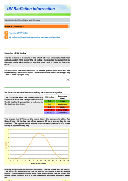

© Copyright 2026