
OOI RFA Cover Sheet Beaufort/Chukchi Shelf
OOI RFA Cover Sheet LOI Full Addendum Above For Office Use Only Please fill out requested information in all gray boxes The Barrow Coastal Observatory; A Cabled Seafloor Observatory on the Beaufort/Chukchi Shelf Title: Proponent(s): Carin Ashjian, Dale Chayes, Bernard Coakley, Margo Edwards, Hajo Eicken, Mark Johnson, Andrey Proshutinsky, Tom Weingartner Keywords: (5 or less) Arctic, Beaufort, Chukchi, Barrow, Alaska Area: Arctic Contact Information: Contact Person: Bernard Coakley Department: Geophysical Institute Organization: University of Alaska - Fairbanks Address 903 Koyukuk Drive, Fairbanks, Alaska 99775-7320 Tel.: 907-474-5385 E-mail: [email protected] Fax: 907-474-5163 Permission to post abstract on ORION Web site: ✔ Yes No Abstract: (400 words or less) Access has always been the primary restriction for arctic science. A cabled seafloor observatory could breach the limits imposed by seasonal variations of sea ice and open the Arctic Ocean to comprehensive, synchronized investigation. During the fall and spring, as sea ice forms or breaks up, the surface is too unstable to stand on and too mobile for boats to operate safely. As a result, our knowledge of shelf processes in this area is skewed towards the relatively stable seasons. Continuous observations would literally open our eyes to the complex, heterogeneous processes we have only glimpsed so far. Barrow is an exceptional place to support an exceptional facility. The existing instrumentation installed and operated by US government and research groups, daily generate an extensive dataset on atmospheric, land and ocean surface conditions. Coupling these observations with synchronized observations from a cabled observatory would permit comprehensive monitoring of the northern Alaskan environment. Three primary sites for instrumentation have been identified; 1) Barrow Canyon - is both a conduit for water and marine mammals into the deep Arctic Ocean. Monitoring of fluxes and associated marine mammal migrations through the canyon would constrain the input from the Pacific Ocean. 2) Shelf Transect - east of Barrow Canyon and north of Point Barrow on the Beaufort Shelf is a relatively high segment of the seafloor. Flow separation between the eastwardly flowing Pacific Ocean water and the much larger Beaufort gyre takes up different positions each year across the shoal. Sea ice also advances and retreats across the shoal. Continuous observations, acquired from a group of sensors arrayed north to south along the seafloor would be the best way to characterize these heterogeneous processes. 3) Deep Basin - monitoring the Beaufort gyre and providing a deep, quiet location for seafloor seismometers and acoustic tomography experiments would favor selecting a site off the shelf and beyond the slope in the Canada Basin. Almost no other place is as vulnerable to climate change as Barrow or is as dependent on the environment. Already, through rapid beach erosion and changes in the distribution of plant and animal species, the effects of change are evident across northern Alaska. A seafloor cabled observatory would give the world a window on the Arctic and provide Barrow tools to integrate quantitative observations with the thousands of years of empirical knowledge possessed by the native peoples of northern Alaska. Please describe below key non-standard measurement technology needed to achieve the proposed scientific objectives: (250 words or less) 1) Short range acoustic tomography - to enable observation between instrumented sites. 2) AUV Docking capability - to enable observations between instrumented sites. 3) Automated AUV acoustic navigational aids. 4) Seafloor resident ROVs for short range activities around instrument sites. Proposed Sites: Site Name Barrow Canyon Beaufort Shelf Canada Basin Position 156°15' W, 71°27' N 155°W, 71°30'N 154°W, 72°22'N List of Project Participants Bob AndersonSAIC Hugh AndersonSAIC Del BohnenstiehlLDEO Alan ChaveWHOI Lee CooperU of TN Seth DanielsonUAF - IMS Bob DetrickWHOI Craig GeorgeNSB Jackie GrebmeierU of TN Cathy HanksUAF Roger HansenUAF Dave KadkoRSMAS Craig LeeUW - APL Bonnie LightUW - APL Andrew MahoneyUAF Molly McCammonAOOS Peter MikhalevskySAIC Sue MooreNOAA Jamie MorisonUW-APL Dick MoritzUW-APL David NortonUAF Al PlueddemannWHOI Rob Reves-SohnWHOI Ray SambrottoLDEO Val SchmidtLDEO Glenn SheehanBASC Bill SmethieLDEO Frederich SonnichsenWHOI RobertSuydamNSB RogerToppUAM Rebecca WoodgateUW - APL Suggested Reviewers Water Depth (m) Start Date Proposed Duration Revisits Deploy during (months) deployment ~80 08/2008 Indefinite ~40 08/2009 Indefinite ~2000 08/2010 Indefinite As necessary As necessary As necessary Site-specific Comments Barrow Canyon Array J-box Beaufort Shelf Array J-box Canada Basin Deep Site Project Summary An Arctic Seafloor Observatory – The Barrow Coastal Observatory (BCO) Study of the Arctic Ocean is limited by sea ice and harsh weather that restrict access through most of the year. These constraints limit data acquisition and distort understanding of events, processes and patterns across most of the Arctic Ocean. Breaching this isolation can be achieved through new technologies and adaptation of existing instrumentation to monitor the shelf and basin throughout the annual cycle, independent of surface conditions, to deliver a continuous view of the highly heterogeneous Northern Alaskan shelf where currents and water masses merge and mix as sea ice waxes and wanes. No amount of dedicated ship time could fully characterize these processes. In situ instrumentation is necessary. Cabled seafloor observatories offer the means for continuous, real time access to the water column, underside of the ice and the sediment surface. Given the heterogeneity and variability of this environment, dense, regular observations and re-scalable sampling programs are necessary to understand the processes and biological responses that they engender. In conjunction with existing instrumentation in Barrow, cabled ocean monitoring would permit study of the exchange between the atmosphere and ocean and offer unique opportunities for interdisciplinary research, environmental monitoring, education and the Barrow community. Intellectual Merit Evidence is mounting that a complex suite of interrelated atmospheric, oceanic, and terrestrial changes are now underway in the arctic, affecting every part of the polar environment. Such changes are consistent with global climate modeling studies that consistently show the arctic to be one of the most sensitive regions to climate change. Understanding and quantifying these changes is complicated by the lack of time series data from the circum-arctic environment. Without these data, it will not be possible to predict future change or plan for the consequences of change. The proposed observatory could substantially augment the Study of Arctic Environmental Change (SEARCH) by collecting data on time scales and in a location of critical importance to the questions addressed by SEARCH. The integration of a wider suite of measurements to provide insight into longer-term coordinated changes in the marine environment are also in direct support of the SEARCH mission. These measurements, combined with surface observations from Barrow, would open a window on the ocean shelf, its biology, oceanography and geology. Broader Impacts The BCO would augment ongoing programs, projects in development and redirect ocean science in the region. The Shelf-Basin Interactions Project (http://sbi.utk.edu/), sponsored by NSF and the U.S. Office of Naval Research, has conducted extensive oceanographic surveys across the northern Alaskan shelf over the last three years, and would be enhanced by year-round access. A cabled seafloor observatory literally would open our eyes to how the water column and seafloor are changed by variability of currents and the sea ice seasonal transformation. There are few locations where ocean processes (weather, ice, biology and geology) are so intimately connected to the local human communities as in the Arctic. Whaling and other subsistence activities are part of the physical and spiritual sustenance of the local Iñupiat population. Already, through rapid beach erosion and changes in the distribution of plant and animal species, the effects of change are evident across northern Alaska. A seafloor cabled observatory would give the world a window on this critical part of the Arctic Ocean and the tools to integrate observations of the water column, the seafloor, and the underside of the ice with the thousands of years of empirical knowledge possessed by the native peoples of northern Alaska. -3- Program Rationale Historically, Arctic oceanography has devoted considerable attention to large-scale seafloor structure, ocean circulation, hydrographic fields and regional biological and chemical standing stocks. Expedition-based observations have been augmented by moored or ice-tethered instruments, providing year-round data during deployments. With increased knowledge collected over an extended period, variability on short and long timescales has become apparent but is not well understood. Permanent seafloor instrumentation is the only way to understand this variability (minutes to years) in the context of what may be rapid climate change (years to decades). The scientific potential of a cabled seafloor observatory in the Arctic was explored by participants of a U.S. National Science Foundation (NSF)-funded open workshop, “Science and Education Objectives for a Seafloor Cabled Observatory on the Beaufort Shelf, Alaska,” held early this year (Coakley et al., 2005). Thirty-two people representing academia, government, private industry, and citizens of Barrow participated. These discussions form the basis for this RFA. Discussions of what permanently installed seafloor instrumentation could accomplish for science, for Barrow, Alaska and the residents of the circum-arctic ranged widely across disciplines including chemical, biological, and physical oceanography; geology and geophysics; and marine mammal and ice canopy studies. The key questions and problems addressed included; ♦ How would a cabled observatory for Arctic studies be designed? ♦ Where and how it should operate? ♦ What are the important engineering and science constraints for this facility in the Arctic? ♦ What are the science and education objectives for such a project? The Beaufort Sea Shelf is a Key Location Barrow, Alaska, located at the juxtaposition of the Chukchi and Beaufort seas, is ideal for investigating oceanographic processes pertinent to basin-scale and regional processes. The Beaufort and Chukchi shelves are characterized by complex oceanography that dramatically affects local ecosystems. Because this region is particularly sensitive to environmental changes, understanding the variability and the linkages between and within the atmosphere and the ocean are necessary to constrain change, to predict how it will evolve over time, and to develop plans to mitigate the consequences to local communities. The regional oceanography sets the stage for this facility. The shelf environment is dictated by the interaction between shelf, slope, and basin currents. On the Beaufort Shelf, this interaction is largely between water from the North Pacific, flowing through Barrow Canyon into complex and poorly understood boundary flows along the continental slope and the Beaufort Gyre, which dominates circulation in the Canada Basin. The connections among these current systems result in mixing and exchanges between the shelf and the basin. This complex interaction is influenced by water mass modification processes associated with the annual freeze/melt cycle, by winds, and by the steep and complicated bathymetry. The various currents transport organic material and nutrients between regions, which affects ecosystem structure, function, and chemical cycling. Very little is known about these ecosystems, particularly with respect to seasonal variation. Observing these changes beneath the ice, and through the fall and spring seasons, is not now possible. Permanent installation of oceanographic sensors on the seafloor would make study of these complex processes possible. -4- From the science and instrumentation talks at the workshop, three areas emerged as priorities for instrumentation as a part of a cabled seafloor observatory: ♦ Barrow Canyon is a conduit for water and marine mammals into the deep Arctic Ocean. Monitoring of the transport of water and sediment, and of animal migration, through the canyon was seen as necessary to understanding the regional oceanography. ♦ Beaufort Shelf, east of Barrow Canyon and north of Point Barrow on the Beaufort Shelf, is a relatively shallow portion of the seafloor. Here Pacific waters from the Chukchi Sea shelf join polar waters associated with the Beaufort Gyre and deeper waters of Atlantic Ocean origin, modifying the properties of these water masses and altering the stratification of the Canada Basin. Regional sea ice processes are likewise complex reflecting both basin scale thermodynamics and poorly understood shelf ice thermodynamics. Many of these issues are difficult or dangerous to observe from the surface. ♦ Canada Basin, in the deep water north of the Beaufort Shelf, contains a more typical, oligotrophic Arctic environment (Beaufort Gyre). Monitoring of the annual cycles in physical, biological, and chemical water column properties would be possible. It would also be a quiet location for seismometers and cross-basin acoustic tomography. A suite of oceanographic instrumentation was proposed that would document coupled physical, biological, chemical, and geological processes, and that would take advantage of the infrastructure capabilities of a cabled observatory (kilowatts of power and gigabit-rate data transmission). Flexibility of observatory design was judged extremely important in order to accommodate new sensors and instruments in the future as they are developed. For example, passive acoustic monitoring would support comprehensive and continuous surveys of marine mammal populations. Active acoustic instruments would enable study of the seabed, currents, plankton distribution, water temperature and the underside of the ice canopy, including ice thickness. Sophisticated chemical (e.g., nutrient analyzers) and biological (e.g., flow cytometers, video and optical plankton recorders, benthic samplers) sensors that require high power and collect large volumes of data could be deployed, as well as more traditional biological sensors (e.g., pH, oxygen, fluorescence, light). Perhaps the greatest potential for this facility is the variety of synoptic measurements that could made be to study coupling between the various oceanographic properties including marine life. Addressing the critical science issues raised by the heterogeneous processes seen in the Arctic Ocean and observing ongoing climate change throughout the four seasons will only be accomplished with a cabled seafloor observatory. Continuous real-time observations of the shelf environments off Barrow would also create a wide range of formal and informal educational opportunities. These could support innovative education projects with native Alaskan populations and open a window on the Arctic Ocean to the world. Also, from a practical perspective, real-time information regarding oceanographic conditions off Barrow (e.g., currents, wave height, ice cover) would enable local residents to make informed decisions about the weather and ocean conditions. A key aspect of the BCO is an ability to design real-time adaptation into the sampling strategy. Strategies with intelligent design adapt sampling based on analysis of the real-time observational stream. For example, when sampling rates change as conditions dictate, information increases while resources are optimized. "Smart" experiments that adapt, evolve and learn become critical paths toward new knowledge especially in the Arctic where the seasonal ice cover and extreme conditions narrow the traditional sampling season. -5- The suite of measurements carried out by an integrated observatory system off Barrow would also constitute an important contribution to the Distributed Marine Observation Network proposed as part of the SEARCH implementation plan (SEARCH SSC, 2003). SEARCH plans are particularly encouraging of enhancing and deepening observations at existing sites to obtain more insight into temporal variability in the Arctic system on subdaily to multi-decadal timescales. The BCO would directly support of such an approach. Barrow Alaska and the Beaufort Shelf Barrow is an exceptional place to support an exceptional facility. The existing instrumentation, much of it permanent, installed and operated by NOAA and a few research groups (Appendix A), daily generates an extensive data set on atmosphere, land, and ocean surface conditions. Coupling these observations with synchronized observations of the seafloor, water column, and water surface (frozen or not) would make comprehensive monitoring of the northern Alaskan environment a reality. This would be a conceptual leap beyond the “investigator who brings an instrument” model, and make it possible to establish mechanistic links across discipline. This integrative observational capability would substantially enhance and could be the centerpiece of the Barrow Global Climate Change Research Facility. -6- Scientific Objectives Each of the target locations was identified as a location where particular processes could be studied in detail (Coakley et al., 2005). The questions outlined below, drafted in break-out groups during the Barrow meeting, form the basis for instrument selection and positioning along the two identified transects and one remote location. Each of these three locations could be served by a single junction box on the seafloor. Barrow Canyon ♦ How does the transport (onto and off of the shelf) through Barrow Canyon of water, salt, heat, nutrients and biotic and abiotic materials change seasonally and inter-annually? ♦ What is the relative importance of transport onto the shelf relative to transport out of the canyon? ♦ How do these different transports modify water mass distribution, biology, chemistry, and flux of carbon to the benthos? ♦ What role do upstream polynyas have on brine injection, halocline maintenance? Beaufort Shelf Transect ♦ How are different water masses (e.g., Pacific Waters from the Chukchi shelf, Atlantic Water, Beaufort Gyre, river inflows, brines from ice formation) distributed and mixed by shelf processes? ♦ How does the juxtaposition between the different water masses influence biological and chemical distributions, standing stocks, and production? How do physical processes along the shelf concentrate organisms? Or enhance production? How are these related to interannual and decadal variability and the phase of the AO? ♦ How does the circulation and mixing of these water masses vary seasonally and in response to climate variations (e.g. global warming or the Arctic Oscillation (AO))? ♦ How does the sea ice formation, ablation and changes in its distribution affect the water column and life within it? ♦ Is eddy generation (number, location) linked to the transport and mixing processes observed in the Canyon and along the shelfbreak? ♦ To what extent are water and material transported across the shelf or along shelf? ♦ How is the shelf influenced by storms? What is the sand budget for the shelf? How do storms disrupt the hydrographic, and biological, vertical structure of the shelf ecosystem? How frequent are such disruptive storms? ♦ What are the seasonal cycles in biology, chemistry, and hydrography? How does this change with advective events and the timing and extent of ice cover? How does this change with AO regime? How does it impact upper trophic levels? ♦ How does the physical (hydrographic, ice extent and persistence) and biological (plankton and benthic abundance) environment on the shelf impact marine mammal (e.g. bowhead whale, walrus) migration pathways? What are the abundances of marine mammals? What influences interannual changes in migration routes and local abundance? Are such changes associated with AO regime? Deep Basin ♦ How do Beaufort Gyre transport and water properties vary inter-annually and seasonally? ♦ How is the deep basin influenced by the formation and loss of sea ice? ♦ To what extent do marine mammals migrate into the deep basin? -7- ♦ What is the low-level seismicity of the Arctic Ocean? All of these questions could be addressed with data collected from cabled instruments, collecting either continuous, regularly sampled measurements or to collect densely sampled measurements associated with particular events. In addition to collecting densely sampled time series at each instrument site, it is desirable to improve spatial resolution either through short distance acoustic tomography or deployment of docking AUVs. The particular questions listed above can be addressed through measurements at particular points, along a vertical profile or with upward or downward looking instruments. In addition to the arctic-specific issues of change and sea ice evolution, the variety of land-based instrumentation now in Barrow (Appendix A) will also make this an outstanding facility to study air-land-sea over a broad range (minutes to decades) of time scales. -8- Experimental Design Site Specific Issues for an Arctic Coastal Observatory The bulk of the instrumentation that would be used in this program will not require modification to be used in the Arctic Ocean. The site itself is the primary obstacle to developing a successful seafloor observatory. Resolving these site-specific issues is critical to implementation of a cabled observatory on the Northern Alaskan shelf. Many of these issues were raised at the first of two planning workshops for this facility. The information gathered at the first workshop (Coakley et al., 2005) is the basis of this RFA. NSF-funded Planning Workshops for the Barrow Coastal Observatory The first workshop, held in Barrow, Alaska on February 7th and 8th 2005, defined the science and education requirements for a cabled seafloor observatory on the Beaufort Shelf. With these requirements in hand, a second workshop will focus on engineering requirements for the BCO. An Engineering Workshop on the BCO The second workshop will be held at the Monterey Bay Aquarium Research Institute (MBARI) in late 2005 to facilitate involvement of the extensive engineering groups resident there and nearby. MBARI is the site of the Monterey Accelerated Research System (MARS) project, which is a technology testbed for cabled observatories. Holding this workshop there will facilitate the full participation of MARS personnel. Attendees will include a subset of the Barrow meeting (Coakley et al. 2005) participants as the focus of this meeting will be on the engineering requirements based on the science mission requirements. Based on the science defined at the Barrow workshop, the engineering workshop will focus on: ♦ Adaptation of existing sensors and cabled observatory technology for the Arctic. ♦ Cabling requirements for anticipated power, communications support and data return. ♦ Identification of site restrictions for installation of junction box(es) and instrument packages. ♦ Site selection procedures. ♦ Computing and communication requirements. The report from this meeting will: ♦ Present a viable implementation plan based on the proposed science program. ♦ Explain the rationale for the proposed sensors and capabilities. ♦ Include a time line and estimated budget for development, deployment and operation of the system. ♦ Outline coordination with the Barrow Global Climate Change Research Facility (BGCCRF). ♦ Identify particular sensors and technology for the cabled observatory as well as design requirements and environmental restrictions imposed by the Beaufort Shelf. The final, combined report from the Barrow and MBARI workshops will define the science rationale and technical requirements for fabrication, installation and operation of the cabled seafloor observatory supported by the BASC on the Beaufort Shelf. Once this report is complete, two of the participants will go to Barrow for a final public presentation of the proposed seafloor observatory. This will keep the residents of Barrow informed and offer the opportunity for further comment. This final report should provide sufficient documentation and information to make it possible to estimate budgets for this project and, ultimately, develop a proposal to -9- appropriate agencies. While this work is not complete, it is important to participate in the RFA process to engage the larger ocean observatory community and obtain their comments Cable Installation The seafloor north of Barrow has been heavily gouged by ice (Figure 1 and Shapiro and Barnes, 1991). This gouging extends across the shelf, to water depths of 20 or 30 meters. Understanding the distribution of these gouges across the shelf and the depth to which ice churns the surface sediment is necessary to planning a secure cable installation. Figure 1 – The complex ice environment are both an obstacle and a primary objective for the BCO. Figure from Craig George, North Slope Borough. The most likely installation will include a combination of directional drilling and trenching to protect the cable from ice damage and exposure in the surf zone. Given the low shelf gradient in the vicinity of Barrow, it may be necessary to drill 4 to 5 kilometers (or more) to achieve this. This approaches the limit for existing directional drilling technology and would be expensive. It may be possible to drill for the near shore and trench the cable in below the seafloor out to the necessary water depth. The US Navy trenched a one inch armored cable two meters into the seafloor during the midseventies. The cable extended from the Naval Arctic Research Laboratory (NARL) to some distance offshore. While this project was observed by many Barrow residents, there is no public information about how long it functioned or what instrumentation it served. The PIs are seeking more information about the location and present condition of the cable (if it still exists). If it could be demonstrated that it functioned or is still continuous, this information would be quite helpful for the design process. This RFA assumes a single cable landing in Barrow. A second cable landing, perhaps in Prudhoe Bay, would open up additional possibilities for instrumentation and support from the oil -10- industry, which has extensive mandated monitoring requirements for its various offshore facilities and operations. A second landing would also eliminate the vulnerability of this observatory to a single point failure and make it possible to perhaps deliver some additional services to Barrow, Alaska (eg. direct connection to fiber optic broadband internet) that could attract additional support. Seafloor Surveys for Cable Routing Regardless of the method chosen for installation, a detailed seafloor survey will be necessary to pick the best location to minimize the length of cable that must be protected from ice gouging. This could be accomplished either by identifying protected areas on the seafloor that are not gouged or finding the area of the steepest shelf gradient, which would permit the shortest possible transit across the gouged zone. A high-resolution swath bathymetric survey, supported with Real Time Kinematic (RTK) GPS data, sidescan imaging, chirp sub-bottom profiling and coring will be necessary to optimally locate a cable on the Beaufort Shelf. These data would document the extent of gouged seafloor, the depth of disturbance in the sediment and estimate the age of scours. A second survey, one year later, would make it possible to directly observe the short term extent of gouging as well as sediment movement that might complicate a seafloor installation. However installation decisions will be made based on a twenty-year survivability. Permitting and Community Relations The activities proposed in support of a cabled coastal observatory would require permitting from at least two Federal agencies. The Minerals Management Service would likely require an Environmental Impact statement before permitting any slant-drilling or seafloor trenching. Installation and operation of this system, due to active sonars (ADCP, tomography, mapping the underside of the ice and the seabed), would require an Incidental Harassment Authorization (IHA) from the National Marine Fisheries Service. There are also likely to be State and other Federal permitting requirements. For many years, the only wage earning jobs available in Barrow were for natives supporting various science and US Navy activities. As a result there is a positive view of science as providing for the community. The perception of any particular project is directly connected to how it is perceived as delivering ideas and data of use to the community as well as jobs that could result. Collaboration and consultation with the local community are essential. The residents of Barrow are keenly interested both in the science that would result from a cabled seafloor observatory and in protecting the subsistence resources they rely on for some of their diet. Their subsistence hunting and harvesting of marine and terrestrial fauna is part of their intimate relationship with the land and water around them. Their long relationship with the coastal environment has provided them with critical knowledge regarding the seasonal cycles in the distributions of subsistence animals. As a result the local community has very clear ideas about how and when the sea should be accessed in order to best avoid disrupting the availability of subsistence food animals. The local community has developed agencies to use science to properly document and support their use of subsistence animal resources such as the bowhead whale. The responsibility for providing census information to the International Whaling Commission integral to the establishment of bowhead whaling quotas by that body and the monitoring of whaling and adherence by whalers to the established quotas both are accomplished by community -11- organizations. The Alaska Eskimo Whaling Commission (AEWC) takes responsibility for monitoring whaling strikes and adherence to the quota while the North Slope Borough Department of Wildlife Management provides scientific data on the health and abundances of subsistence animals including marine mammals. The establishment of the BCO would provide data relevant to the interests of both of these entities. One key issue is to avoid disruption by science related activities of the two annual bowhead whale hunts (spring and fall). This can be accomplished by involving the interested local entities, particularly the Alaska Eskimo Whaling Commission, both in the planning of the observatory and in Alaska Eskimo Whaling Commission in the evaluation of applications for IHA. Access restrictions imposed on the Beaufort Shelf during the annual whale migrations, times of active change on the Beaufort shelf, are one of the reasons a cabled seafloor observatory is necessary to study this region in detail. The first workshop for this project (Coakley et al., 2005) was held in Barrow in early February of this year. This facilitated direct input from the community. After the workshop was held, a few of the conveners stayed on in Barrow to deliver a community presentation and visit with the Mayor of Barrow and the President of the Barrow Whaling Captains Association. The news of the workshop and plans for the cabled observatory were well received. This was the first step in partnering with the Barrow community in development of the BCO. Site Preparation Recognizing that the site preparation issues are critical long-lead items for the development of a cabled coastal observatory in Barrow, a proposal is being prepared for the sensors and cyber-infrastructure program within Arctic Natural Sciences at NSF, the program that funded the Barrow workshop. This proposal will request funds to pay for a desktop study of existing bathymetry data on the Beaufort Shelf by a licensed hydrographer and an assessment of the permitting issues raised by this project by an experienced environmental consultant. The desktop study will identify likely locations for system nodes and instrumentation and develop cruise plan for the detailed surveys described above. The permitting evaluation will result in a list of the permissions necessary to build and operate this facility. Existing and Planned Facilities in Barrow One of the advantages of the Barrow location is the array of atmospheric, weather and sea surface sensors already installed there (see Appendix A). Atmospheric measurements are collected at multiple levels from towers, by regularly launched weather balloons and with radar. This is perhaps the best-instrumented site on the Arctic Ocean. Additional instruments operate further inland at Atqasuk and Toolik Lake. With these existing sensors and support facilities and the planned expansion of those facilities Barrow is well-prepared to support this cabled seafloor observatory. Barrow Global Climate Change Research Facility (BGCCRF) After extensive consultations with the science users and Barrow residents, construction of the first phase of the Barrow Global Climate Change Research Facility has begun, with the pace set to increase after materials arrive via barge from outside. This first year’s construction will build lab and office space. As each of the new phases is built over the next four years, the BGCCRF will expand to offer greater scientific support services, including machine and electronics shops, staging areas, multi-media resources, high bandwidth internet connectivity, living spaces and meeting rooms. It is the natural facility to support the BCO. -12- Barrow Arctic Science Consortium (BASC) BASC will operate the BGCCRF. BASC is dedicated to the encouragement of research and educational activities pertaining to Alaska's North Slope, the adjacent portions of the Arctic Ocean, and in Chukotka, Russia. BASC is a community-based organization dedicated to helping make closer contacts between scientists and community members. A cooperative agreement between BASC and the National Science Foundation's Office of Polar Programs provides funding for BASC's activities. BASC provides logistical support for Arctic research and strives to facilitate the exchange of knowledge between scientific researchers and the people of the North Slope. BASC supports the development of this observatory (see attached letter Appendix B). Instrumentation The advantages of cabled seafloor observatories are most obvious in the Arctic Ocean, matching the need for further observations of this restricted, seasonally ice-shrouded environment. Many types of instrumentation have been and are being developed for autonomous operations on moorings and other independent seafloor deployments. These instruments could be adapted and augmented as components of a cabled observatory. Comparatively unrestricted power and two-way communications offer a variety of options for the operation, including the ability to adjust sampling, modify software and recognize and recover from some types of faults. Examples of these instruments and sensors include: Visual Monitoring - scheduled, remotely triggered and/or event triggered. ♦ Broadband Acoustic Monitoring - identification and tracking of marine mammals, acoustic ♦ Tomography, acoustic thermometry and SOSUS-like applications. ♦ Seafloor Seismometers - improved radial coverage of the Arctic Ocean and Alaska. ♦ Oceanographic Instruments - to monitor the water column. ♦ Active Acoustic Instruments - to observe currents, the seafloor and the ice. ♦ Bottom Tethered Instruments – to monitor the entire water column under the drifting ice. ♦ Observations of Sea Level Variability – a record free of near shore and tidal effects. ♦ Autonomous Underwater Vehicle (AUV) Docking- to extend range and length of deployment. ♦ Intercommunication between Cabled Observatories elsewhere in the Arctic ♦ For AUVs and Drifters – act as a beacon and kiosk for other water column activities. Computer System Requirements for a Cabled Observatory A computer system will be necessary to control access to the instruments as well as to collect, validate, archive and distribute data. Consistent execution of these functions argues for separation into distinct computer systems to facilitate security and promote stability. The particular functions for this system would include: ♦ System Monitoring and Control – two-way flow of system status information and instrument control commands. ♦ Data Acquisition and Quality Control System – the onshore system to ensure data integrity. ♦ Data Access System – a restricted access system to permit password access to data. ♦ Web Presence – a public portal for general access to the real-time and historical data. Isolation of different activities into separate computer networks provides differing levels of -13- access for distinct user communities and ensures data and system security. Instrumentation Sites While each of the sites is designed to address particular geographically specific questions about the Northern Alaskan shelf and the Arctic Ocean, the collection of proposed sites offer opportunities for monitoring and observation across the entire region (Figure 2). The collection of instrumented sites that could be supported through the BCO could be utilized in concert to address larger scale issues, for example the influence of the shifting ice edge or the boundary between the Beaufort Gyre and shelf currents (Figure 3) on the water column, biology and the seabed. The set of sites also provides a convenient means to break the entire program down into units that could be installed in a single season. A number of design issues influence selection of instruments for all of the sites. In addition to defining the horizontal limits for installation of sensors, the penetration of ice into the water column also defines a vertical limit. This does not present a problem for acoustic instruments (ADCP etc.), but many of the desired instruments require contact with the water (eg. CTD). In order to obtain measurements as close to the surface as possible, in all seasons, these will have to be tethered. Tethered instruments can be raised and lowered as necessary, through the shallow water column, through the region of maximum variability and returned to safety near the seafloor, below the impact of ice keels. The full description of these sites awaits the planned engineering meeting at MBARI this Fall and subsequent discussions with the interested scientists (see list on cover page). Text and budgeting in this RFA assumes that each of the three sites will be served by a single junction box, feeding from a primary junction box on the seafloor some distance beyond where the cable emerges from the bottom. Each of the transects will consist of a series of instrumented locations, spaced approximately five km apart. Exact location of these fixtures on the seafloor will await the detail surveys discussed above. Figure 2 – Sensor localities define at the Barrow meeting. Bathymetry from JOSS website (see; http://www.ofps.ucar.edu/) -14- Additional sensor specifications defined in Barrow; ♦ Sensors should be profiling to obtain samples within the near surface water column. ♦ Biological, chemical, and physical parameters should be measured at the same temporal and spatial density ♦ A maintenance plan must be developed for annual/biannual servicing and swapping out of sensors for calibration ♦ Develop a node ROV with 1 km range to exploration of the water column and seafloor and repositioning of small sensors. ♦ Docking AUV is needed to resolve the horizontal variability between instruments, provide detailed measurements of discrete features and study the ice gouged zone. ♦ Establish transponders or acoustic beacons along line to guide AUV. Integration of shore based (eg. radar to track ice movement) will make it possible to better direct the sampling of the AUV and to correlate the water column observations with the ice movements and texture. AUVs should be equipped with upwards looking camera, bio-acoustic sonars, CTD, ADCP, fluorometer, oxygen sensors, backscatter sensors among other instruments. Figure 3 – Complex circulation patterns shift across the Beaufort Shelf, interacting with the ice and atmosphere. Being able to observe these changes in real-time as well as the biological consequences of these changes, would lead to a wholistic understanding of the Beaufort Shelf environment. Beaufort Shelf Transect This transect will be ideal for studying the shifting currents that sweep across the Beaufort shelf and the consequences of movement of the ice edge over the array (Figure 3). Approximately fifteen instrumented sites along this transect will enable study of circulation, mixing and other processes at short and long timescales. -15- The junction box for this transect will sit in approximately 40 meters of water, well beyond any ice gouging. A line of sensor clusters will extend along the profile (Figure 2), spaced at maximum of ten km. These sensors will extend from as close as is practical (20 to 30 meters water depth), given the ice gouging observed during the preparatory surveys, to approximately 400 meters water depth. The cable could extend into deeper water to accommodate future offshore work. An AUV or ice buoy will be necessary to support any work within the ice gouge zone. Barrow Canyon Transect It is well known that Barrow Canyon is a conduit for the deliver of water from the Pacific Ocean to the Beaufort shelf (Figure 3). It is also clear that bowhead, gray and beluga whales follow that current north during their Spring migration (Figure 4) to their Summer range near the US-Canada border. Simultaneous observations of water column properties and tracking of marine mammals will result in improved estimates of whale populations and better understanding of the oceanographic influences on their behavior. This transect (Figure 2) would also provide valuable information about the transfer of relatively fresh water from the North Pacific through Bering Strait and mixing processes in the canyon and on the shelf. Figure 4 – Bowhead whale sightings and acoustically determined positions cluster along Barrow Canyon. Figure from the Barrow Area Information Database (ims.arcticscience.org). The transect will be serviced through a single junction box located in approximately 80 meters of water. This transect will be instrumented at a series of nodes spaced every ten kilometers. Approximately ten instrumented locations extending from near the head of the canyon to about 200 meters water depth will be adequate to constrain the important processes in this area. Deep Basin Site The deep basin site is the northern limit of observations that would be collected from this facility. It would define boundary conditions for both arrays on land, provide a quiet location for seafloor seismometers, collect real time observations of the Beaufort Gyre (Figure 3), and could, in conjunction with other arctic observatories, be a receiving and transmitting station for basinscale acoustic tomography experiments. The cable servicing this site would also be an -16- opportunity to instrument other useful sites between the deep basin and Barrow, particularly the shelf-slope break, the slope and the base of slope, if other investigators desired. There would be a single junction box with several branches; ♦ Acoustic hydrophone array w/standard suite of oceanographic sensors ♦ Seismic array on a separate wire ♦ MacLane Moored Profiler w/standard suite of oceanographic sensors (see; http://www.frontier.iarc.uaf.edu/~dwalsh/Mackenzie.html) Education and Public Outreach The broader goals of the BCO are achieved through education to the general public, school children, high school and college students and science professionals. By opening this window on the Arctic Ocean at a time of great controversy about climate change, the data will, if properly packaged for groups with different interests and skill sets, answer questions and yield to analysis. With access to broadband Internet, it will be possible to view real-time data and interact with searchable databases to observe, formulate questions and answer some of those questions. Informal Education The evidence of the senses is a place to begin. Knowing what something looks like or sounds like is an experience beyond analysis and a means of directly engaging even unsophisticated viewers. For example; ♦ Directable Video Cameras (ice dynamics, biota) ♦ Site Selectable Passive Acoustics “Webradio” (fauna, ice dynamics) Being able to select the site and compare different sites is the beginning of analysis. A searchable database that would enable viewers to select a set of regularly generated digital photos or sounds samples, which would enable comparisons across days, seasons or years would give depth to the current observations and expand awareness in time about change over time. Museums also provide excellent opportunities for reaching out to the public with prepared exhibits, incorporating and giving context to real-time data streams. The University of Alaska Museum has expressed interest in participating in this project and would take the lead in developing exhibits on topics of general interest, such as; marine mammal migration, ice dynamics, climate change and human adaptation to change. Regional Public In developing the BCO, it is necessary to think seriously about how it can serve Northern Alaskan coastal communities, Alaskans and circum-arctic residents. While a public outreach program has begun in Barrow, it will be necessary to continue this effort through the life of the facility. Data of particular interest to Arctic coast communities includes; ♦ Ice information – is the ice stable and safe for travel or hunting? ♦ Sea level change – better constraints on sea level rise. ♦ Sediment dynamics – sand budget as a component of shoreline retreat. ♦ Whale census studies – are the Bowheads endangered? ♦ Contaminant monitoring. These communities would benefit from; frequent public reports and presentations, expert interpretation of data, availability of data and delivery of products to government agencies. While the BCO has much to offer local communities, there is also much to be gained through interaction with people who have had decades of experience hunting and working on sea ice and -17- on the water. These memories are time series of events and observations of changing conditions that should be incorporated into the education and science accomplished through the BCO. Kindergarten through High School Education Developing lesson plans for all grade levels that would frame a set of questions on different topics for teachers to present to students is probably the most effective means of reaching many schools nationwide. These lessons could include interaction with the real time data at various sites or not. Additional teacher support could be delivered through documentaries and videos on particular topics of interest. Connecting students directly to the science enterprise either through Teacher and Researchers Exploring and Collaborating (TREC) program, or by soliciting proposals for student-initiated research projects would be a means to engage more advanced or adept students. College and Professional Education At this level, the BCO itself, not just the data it delivers is an object for study. Students at this level are not merely consumers of information, they can, through their interaction with the facility, come to understand how its flexibility might be exploited for purposes different from the original intent. This education begins with direct access, which can be arranged in different ways; ♦ Interns on site (general, or targeted to assist with science, technology or outreach). ♦ Remote interns (granted enhanced access for a particular activity or period of time). ♦ Limited-term science team members. ♦ Field seminars with rotating sponsorship among PIs’ institutions. ♦ Research Experience for Undergraduate (REU) programs. ♦ Visiting instrument specialists ♦ Supporting the Ilisagvik College science technician-training program. -18- Program Management During the time covered in this RFA, the BCO would evolve from an initial planning process, through site evaluation and installation to full operation. Development of the BCO will require careful sequencing of a variety of activities as well as orchestration of a wide range of user groups to make the most of the opportunities that it can offer. Planning Phase This process was begun with the submission of a collaborative proposal from the Geophysical Institute of the University of Alaska, Lamont-Doherty Earth Observatory and Woods Hole Oceanographic Institute. Three of the proponents of this RFA (Coakley, Chayes and Proshutinsky) were lead PIs for their respective institutions. The grant was awarded in the Fall of 2004 from the cyber-infrastructure and sensors program in the Arctic Sciences Section. These funds, augmented by logistic support from the BASC at no charge to the grant, covered participant support costs for the workshop on science and education objectives for the BCO. The ideas in this RFA are largely drawn from the draft report for that meeting, which will soon be circulated for public comment. 2005 In the Fall of this year, a second workshop will be held at the MBARI to discuss the how best to design the BCO so that the education and scientific objections worked out in Barrow (Coakley et al., 2005) can be met. The resulting report from this meeting will provide a basis for more effective planning of the proposed instrument network. In the next few months, a second proposal will be submitted to cyber-infrastructure and sensors program to cover the costs of evaluation of the permitting requirements and identification of possible locations for cables, junction boxes and seafloor instrumentation. If funded, this project will support a licensed hydrographer to perform a desktop study, based on the existing bathymetric data set, to identify possible installation locations and plan a highresolution survey to locate preferred locations and routes on the seafloor. An environmental consulting firm will be paid to evaluation the regulatory burden for the program from site preparation to full operation. The US Navy installed cable may be accessible on the ground east of Barrow. If it can be found, it will be possible to test it for continuity and length. If it is still continuous across the ice gouge zone, after more than thirty years, it will be clear that trenching the cable to two meters is adequate to protect it. Knowing this would greatly simplify preparations for the BCO. 2006 In the first part of the year the combined report from the Barrow and MBARI workshops will be released. Later in the year, if the proposal described above is successful, reports on the permitting responsibilities and possible sites for seafloor installation will be made available for comment. Subject to seafloor mapping, it will be possible this year to plan cable routes, instrumentation sites and instrumentation packages for these sites, making realistic budgeting a real possibility. Outreach to the Barrow community will continue. These reports will be circulated for comment and be the basis for a series of public presentations in Barrow. Expanding access to the water column can serve many interests and be a basis for cooperation and additional funding for the BCO. Much of the activity for next year will focus on identifying potential collaborations with other groups interested in the North Slope and Alaskan coast. These include other organizations with monitoring obligations or needs, particularly the oil -19- companies, the Minerals Management Service, the Alaska Eskimo Whaling Commission and the Barrow Whaling Captain’s Association. Depending on the level of enthusiasm encountered among these groups, a second cable landing at Prudhoe Bay, which would support additional instrumentation and eliminate vulnerability to a single point failure, should be considered. A second cable landing would require significant industrial support and could offer some level of service (eg. fiber optic connection through the Trans-Alaska Pipeline cable) to Barrow. Start of OOI Funding Development of the BCO will be carried forward as described above and continue through the first few years as an OOI project. The sequence described here is critical to ensure that the shelf environment is well characterized prior to the beginning of installation. Staged installation of the BCO allows adequate time for hardware testing and progressive development of support infrastructure during the installation period. Installation in Barrow is complicated by the long-lead time necessary for ordering construction materials (six months for barge freight) and the difficulty in mobilizing ships and other support equipment to this remote location. Substantial advantages may be had by cooperation with other potential users, the oil industry, the North Slope Borough and agencies of the Federal government. 2007 Assuming OOI funding is made available, activities in 2007 would focus on site survey mapping, engineering efforts and planning for installation. A high-resolution survey would be conducted over the prospective sites identified in the desktop study. Multi-beam bathymetric data will be critical to precise location of instruments and routing of cables, but high quality sidescan and chirp sub-bottom profiler data will also be necessary to understand the distribution and age of ice gouging on the shelf. These data will also be useful to Barrow for understanding the near shore environment and evaluating the geologic history and submerged archeological resources of the region. These data will be used to refine the installation plans made in 2006. With these surveys in hand, planning for the cable installation and orders for materials could go ahead. 2008 The primary task for this year will be the installation of the cable connecting the BGCCRF to the junction boxes for all components of the BCO. Laying out the cable in a single year will save on the mobilization expense of an appropriate cable-laying ship. Some instrumentation should be connected at this time to each of the junction boxes, making it possible to begin data acquisition and cable testing for subsequent installations. Depending on the success of the first survey, prudence might dictate a second high-resolution survey to evaluate the distribution of recent ice gouges and the effect of sedimentation and erosion on instrument and junction box sites. With the first deployed instrumentation, initial computer support facilities should be installed in the BGCCRF. Testing of data access tools and archiving processes should be undertaken. 2009 The installation of the Beaufort Shelf array will be the primary objective for this year. At the end of the season, before the sea ice forms up, the array should be in place and functional, offering the first substantial data from the BCO and enabling full-time monitoring operations for the first full season. -20- 2010 Installation of the Barrow Canyon Array will make observations of cross-shelf and along shelf gradients possible as well as intensive marine mammal observations and census work. 2011 Installation of the Deep Basin Site, followed by a transition to full operations After completion of the BCO, there will be a transition to full operations and maintenance, accessing instruments as necessary for upgrade, replacement or repair. This will require either working out how to maintain the BCO from the ice or having a ship or boat of adequate size and resources available in Barrow during the summer season. Management Structure A formal management structure should be implemented at the start of OOI funding. Management of the BCO will require four full-time, dedicated professionals. A chief scientist should be the overall leader, with an outreach expert, computer system manager and engineer reporting to him/her. The outreach expert will be responsible for the education programs derived from the data acquired by the BCO. The engineer will be responsible for hardware maintenance and BCO hardware repairs and upgrades. The computer system manager will be responsible for the data acquisition and archiving system. In addition to these full-time personnel, it would be useful to provide some research scientists with partial funding to act as data stream managers. These individuals would be responsible for higher order quality control that could not be automated and for identifying unexpected data that could either indicate instrument problems or an unusual event worthy of more detailed observations. These managers could work from other locations, interacting with their data streams with tools provided by the BCO that operate over the Internet. The chief scientist should report to an advisory board, consisting of users, Barrow residents and other interested parties. At a once yearly annual meeting and through e-mail they could direct the development and operation of the BCO. -21- Data Management Collecting real-time data will not mean much if it is not possible to access the data shortly after these measurements are made. Interactive control of the instruments in response to events requires near real-time access to data streams. Data management strategies must balance security, quality control and access to serve the users with varying needs and abilities for data interpretation. While the focus is on continuous access to the water column in real-time, if this is to be a useful monitoring facility, data and metadata archival standards will be necessary to permit study of changes over time. Complete integration of BCO collected data with the surface data collected on the North Slope (Appendix A) would facilitate many investigations that cannot be done today. Overarching Data Management Strategy The primary goal of the BCO data management system will be to maximize the amount of data collected, its quality and availability. This goal can be accomplished through: 1) near real-time quality control, 2) adhering to established standards for both data and metadata, 3) developing a flexible approach to data management, 4) promoting interoperability within the BCO and with other cabled observatories, 5) providing a subset of value-added derived data products, 6) facilitating data access and delivery, 7) ensuring long-term physical archival and 8) designing flexibility into the data management system so that future improvements in sensors, infrastructure and data can be readily incorporated. Data Quality Control The BCO will be controlled from an operations center at the BGCCRF in Barrow. During the first year of BCO operations, we propose to have personnel monitoring a standard suite of instruments around the clock to check for data errors in real-time. The longer systemic problems go uncorrected, the larger system drift and errors will be. In parallel with the effort to insure the BCO is operating as designed, we plan to modify and expand existing monitoring applications to provide phone or e-mail notification of problems with specific instruments. As this system is implemented and demonstrated to work successfully, the amount of personnel time required to support the BCO will decrease significantly. When individual projects require the addition of specialized instrumentation to the BCO, we anticipate that the principal investigator would provide the necessary personnel and/or system for monitoring their sensor. Support personnel at the BGCCRF could also provide support either in the form of physical monitoring or modification of existing hardware/software monitoring systems through prior arrangements with the project investigators. Data and Metadata Standards The policy regarding data and metadata standards for the BCO will be identical to that recommended for all seafloor observatories - those contributing to BCO data archives MUST subscribe to the standards set defined on either a national or international level for their discipline. At the present time many of these data and metadata standards are still under development, and there is a significant level of overlap between them. For example, the International Standard ISO 19115 is a Geographic Information Metadata Standard that was formally accepted in May 2003. Almost simultaneously the Federal Geospatial Data Center of the National Spatial Data Infrastructure established the Content Standard for Digital Geospatial Metadata. It is beyond the scope of this document to determine which of these standards the international arctic research community will finally select as the preferred standard, but the BCO could certainly require data contributors to adhere to one of the two and provide filters that could easily convert between them if necessary. -22- Given the unique nature of the arctic environment, it is conceivable that BCO will collect datasets with formats that can’t easily be translated into existing standards. In these instances BCO policy will be to mimic established standards to the greatest extent possible and consistently and abundantly document the unique information. Furthermore, we will work with the appropriate authoritative bodies to expand data/metadata standards in meaningful ways. A critical aspect of BCO standardization will involve frequent, repeated synchronization of time across widely distributed platforms. For example, detailed measurements of ice thickness will entail combining data from upward-looking sonars connected to BCO via fiberoptic cable with altimetry data derived from satellite observations. If the time recorders on these platforms have variable resolution, are not synchronized or drift independently, incorrect values of ice canopy thickness will result. By providing an accessible, accurate “arctic clock” the BCO can assure that these types of errors are minimized. Data Management There are two end-member approaches to managing data collected by any coastal observatory: the first entails contributing all data collected by the observatory into a centralized repository, the second allows datasets to exist within a distributed data system where efforts and expertise are shared by a number of investigators. Because there presently is no centralized repository that contains the entire range of interdisciplinary data that we envision collecting through the BCO, our data management approach lies in the middle of this spectrum. There are several large centralized repositories that we propose to use as data distribution and archival centers for the vast majority of data collected by the BCO including the Arctic System Science Data Coordination Center of the National Snow and Ice Data Center (for oceanographic, atmospheric and cryogenic data) and the National Geophysical Data Center (for geological and geophysical data). Other datasets, for example sidescan and tomography data, are not presented supported by national archives and will need to be maintained, processed and archived by BCO or interested principal investigators until such time as they are added to the catalogs of the national archives. Indeed, the BCO should help develop standards for these unique datasets and can transfer technology for supporting and disseminating them to the national data repositories. Because of environmental conditions around Barrow, the BCO operations center at the BGCCRF has a relatively limited data pipeline. Depending on the quantity of data collected by the BCO, this might require some latency in the real-time data stream. Establishing the data repositories off-site allows us to address this problem while still providing freely available, welldocumented data from the observatory rapidly. Interoperability The first priority of a data management system is to ensure that applications can operate and data can be accessed across a range of platforms. This is especially true for the BCO where those accessing the system will span the range from users with technically sophisticated computers, sensors and infrastructure to those with limited resources and sporadic, lowbandwidth access. We envision providing different levels of access to different users, potentially even with different levels of security. Some BCO scientists will likely have remote access to instruments to adjust sampling or calibration while they are off-site, although we anticipate that on-site staff using will control most instruments established sampling protocols. Similarly, by making data available in a variety of raw, compressed, processed, and derived formats, the BCO will maximize access and usefulness. -23- Derived Products Derived data products such as interpretative maps and sub-sampled data streams add value to any data management system. Often, these types of products result from specific investigations and are subsequently published by the scientific investigators with no effort required by observatory personnel. In other cases, methodologies are developed during a project that can subsequently be automatically applied to yield future value-added products. The BCO will strive to determine what is a "reasonable" amount of value-added derived data products that can cost-effectively be provided to its user community. A fundamental aspect of accomplishing that goal will entail providing an easy mechanism for community feedback so that the BCO can evaluate the value of derived products. Data Access and Delivery We anticipate that data acquired by the BCO baseline instruments will be provided in near real-time via the off-site data repositories. The BCO will provide a web-based portal that will point those requesting data to the appropriate sites. In this way centralized repositories that are already established and equipped for this function will handle data delivery. BCO will be responsible for controlling some data access by categorizing different types of users for the central data archives. Metadata are a useful tool for scientists trying to access, integrate and interpret individual and multi-disciplinary datasets because scientists have a basic understanding metadata, but when it comes to helping less experienced users learn what they need to know using BCO data and approaches, what tools are helpful? Can the BCO be developed so that Barrow school children can benefit from it? We have begun to address this problem by early, on-going interactions with the Barrow community to determine how we can meet their needs while simultaneously supporting scientists. The solution will continue to evolve as the observatory is built, and will undoubtedly entail bringing these disparate communities together, for example, by having scientists teach indigenous people how to operate a Geographic Information System while simultaneously learning about important issues and events that are part of traditional knowledge. Data Archival Data archival will largely be handled by the off-site data centers, allowing the BCO to build off institutions that have mature data management practices. Where unique data are collected via the BCO, observatory personnel will assist investigators in transferring data to established archives. This may including provide temporary archival if necessary to ensure that important historical data are not lost. A successful plan for the BCO data archival must be flexible enough to allow data to be used in ways that were not originally intended. One way to accomplish this is for the BCO to provide documentation that goes beyond what is typically generated as metadata. Future Expansion BCO must assume that instruments, software, protocols, etc. will evolve with time and design its data management system to embrace these changes rather than be hindered or derailed by them. It must provide the link back from the future so that historical and unique datasets (such as local and traditional knowledge) can be used for on-going time-series studies. As with many of the issues raised in this section, the answer to how to accomplish this goal will undoubtedly evolve over time, but maintaining extensive histories not only of data, but of sensors, calibrations, infrastructure, etc. will help the BCO data management system succeed at this task. -24- References Coakley, B.J., D. Chayes, A. Proshutinsky and T. Weingartner, 2005, Objectives for a Cabled Observatory in Alaska’s Beaufort Sea, EOS 86, 177-182. SEARCH SSC and SEARCH IWG, 2003, SEARCH: Study of Environmental Arctic Change, Implementation Strategy, Revision 1.0, Polar Science Center, Applied Physics Laboratory, University of Washington, Seattle, 53 pp. Shapiro, L.H., and P.W. Barnes, 1991, Correlation of Nearshore Ice Movements With Seabed Ice Gouges Near Barrow, Alaska, JGR 96, 16979-16989. -25- Appendix A – Existing Surface Instrumentation at Barrow and Atqasuk From Bernard Zak – Sandia National Laboratories ARM & Related Instrumentation on the North Slope (Spring 2002) Surface Meteorological Sensors Barrow -Wind Speed, Wind Direction, Temperature, Humidity -Same as Above, but at 2m, 10m, 20m, 40m -Dew Point/Frost Point Hygrometer (1 level fixed) -Present Weather Sensor -Standard Precipitation Gauges Atqasuk NOAA/CMDL&NWS ARM ARM&NOAA/CMDL ARM NOAA/CMDL&NWS Yes No Yes Yes No ARM ARM ARM NWS&ARM Yes No No IOPs ARM ARM&NWS NOAA/CMDL No Yes No ARM NSF/NARL ARM NASA/ARM ARM ARM ARM ARM ARM ARM ARM ARM NOAA/CMDL IOPs No Yes No Yes Yes Yes Yes Yes Yes Yes No No ARM ARM ARM Yes Yes Yes ARM, NOAA/CMDL Soon No Wind, Temperature and Humidity Sounding Systems -Microwave Radiometer (MWR; column water & water vapor) -Profiling Microwave Radiometer -915 MHz Wind Profiler w/RASS (WS, WD, T profile) -Radiosondes Cloud Observation Instrumentation -Millimeter Cloud Radar (MMCR) -Micropulse Lidar (MPL)ARMNo-Ceilometer (VCEIL) -Total Sky Imager (TSI) Downwelling Radiation -Extended Range Atmospheric Emitted Radiance Interferometer (ER-AERI; FTIR, 4-26 microns) -UV Spectrometer -Infrared Thermometer -Cimel Sunphotometer (CSPHOT; 8 Wavelengths) -Multi Filter Rotating Shadowband Radiometer (MFRSR) -Normal Incidence Multi Filter Radiometer (NIMFR) -Precision Solar Pyranometer, Unshaded (PSP/DS) -Precision Solar Pyranometer, Shaded (PSP/DD) -Normal Incidence Pyranometer (NIP; pyrheliometer) -Precision Infrared Radiometer, Unshaded (PIR/DI) -Precision Infrared Radiometer, Shaded (PIR/DDI) -Ultraviolet B Radiometer (UVB) -Duplicate PSPs and PIRs Upwelling Radiation -Infrared Thermometer -Precision Solar Pyranometer (PSP/US; 10m) -Precision Infrared Radiometer (PIR/UI; 10m) -Multi Filter RadiometerARMYes -Downward-Pointing Video Camera (snow cover) -Duplicate PSPs and PIRs -26- Aerosol Instrumentation -Multi Wavelength Integrating Nephelometer -Condensation Nuclei Counter (CNC) -Filter Samplers -Micropulse Lidar (MPL) Barrow Atqasuk NOAA/CMDL NOAA/CMDL NOAA/CMDL ARM No No No No NOAA/CMDL NOAA/CMDL NOAA/CMDL NOAA/CMDL SDSU/NOAA/CMDL No No No No Yes Gas Instrumentation -Flask Samplers -Gas Chrom for Greenhouse & Ozone-Destroying Gases -UV Ozone Monitor -Column Ozone Monitor -Eddy Correlation Fluxes (CH4&CO2) *NOAA/CMDL and ARM sensors are co-located on NOAA land NE of Barrow; the NSF sensor at NARL (former Naval Arctic Research Laboratory)is 2 km to the west; the NWS (National Weather Service) sensors and Upper Air Sounding Station are 7 km to the SW near the Barrow airport. CMDL Climate Monitoring and Diagnostics Lab Programs NWS National Weather Service ARM Atmospheric Radiation Measurement Program Other Instruments -Oechel (SDSU) -Yang (UAF) -Konosuke -Hinkel Urban -Permafrost -Eicken (UAF) Carbon Dioxide, Methane, Water Vapor and Sensible Heat Fluxes (BRW & ATQ) Snow Gauge Intercomparison Snow Gauges Heat Island Array Active Layer Measurements Sea Ice Radar Imaging & Measurements -27- Appendix B – Letter of Support from Barrow Arctic Science Consortium -28- -29- FOR ORION USE ONLY CUMULATIVE PROPOSAL BUDGET ORGANIZATION PROPOSAL NO. DURATION (MONTHS) University of Alaska – Fairbanks Campus Proposed PRINCIPAL INVESTIGATOR/PROJECT DIRECTOR Granted AWARD NO. Bernard Coakley A. SENIOR PERSONNEL: PI/PD, Co-PIs, Faculty and Other Senior Associates List each separately with name and title. (A.7. Show number in brackets) 1. BCO Chief Scientist 2. BCO Lead Engineer 3. BCO Outreach Specialist 4. BCO System Programmer 5. _____ 6. (10) OTHERS (LIST INDIVIDUALLY ON BUDGET EXPLANATION PAGE) 7. (14) TOTAL SENIOR PERSONNEL (1-6) B. OTHER PERSONNEL (SHOW NUMBERS IN BRACKETS) 1. ( 2 ) POSTDOCTORAL ASSOCIATES 2. ( 4 ) OTHER PROFESSIONALS (TECHNICIAN, PROGRAMMER, ETC.) 3. (___) GRADUATE STUDENTS 4. (___) UNDERGRADUATE STUDENTS 5. ( 2 ) SECRETARIAL - CLERICAL (IF CHARGED DIRECTLY) 6. (___) OTHER Funded Funds Funds Person-months CAL ACA SUMR 60 D __ __ Requested By Granted Proposer (If Different) 60 60 60 __ __ __ __ __ __ __ __ __ __ __ __ __ 120 __ 120 240 __ __ __ __ TOTAL SALARIES AND WAGES (A + B) C. FRINGE BENEFITS (IF CHARGED AS DIRECT COSTS) TOTAL SALARIES, WAGES AND FRINGE BENEFITS (A + B + C) D. EQUIPMENT (LIST ITEM AND DOLLAR AMOUNT FOR EACH ITEM EXCEEDING $5,000.) 500,000 500,000 500,000 500,000 _____ 720,000 2,720,000 $_____ _____ _____ _____ _____ _____ _____ 500,000 1,000,000 _____ _____ 400,000 _____ 4,620,000 1,542,480 6,162,600 _____ _____ _____ _____ _____ _____ _____ _____ _____ See Budget Justification _____ _____ TOTAL EQUIPMENT E. TRAVEL 1. DOMESTIC (INCL. CANADA, MEXICO AND U.S. POSSESSIONS) 2. FOREIGN F. PARTICIPANT SUPPORT 1. STIPENDS $ 0 2. TRAVEL 200,000 3. SUBSISTENCE 90,000 4. OTHER _____ TOTAL NUMBER OF PARTICIPANTS (200) TOTAL PARTICIPANT COSTS G. OTHER DIRECT COSTS 1. MATERIALS AND SUPPLIES 2. PUBLICATION/DOCUMENTATION/DISSEMINATION 3. CONSULTANT SERVICES 4. COMPUTER SERVICES 5. SUBAWARDS See Budget Justification 6. OTHER _____ TOTAL OTHER DIRECT COSTS H. TOTAL DIRECT COSTS (A THROUGH G) I. INDIRECT COSTS (F&A) (SPECIFY RATE AND BASE) 25,800,000 380,000 90,000 _____ _____ _____ 290,000 _____ 500,000 1,000,000 1,000,000 _____ 16,200,000 500,000 19,200,000 51,922,600 _____ _____ _____ _____ _____ _____ _____ _____ _____ _____ Base 50.4% (less Participant Support and Equipment; only on 1st $25,000 of subcontracts) _____ TOTAL INDIRECT COSTS (F&A) MTDC 3,393,230 _____ J. TOTAL DIRECT AND INDIRECT COSTS (H + I) 55,315,830 _____ K. RESIDUAL FUNDS (IF FOR FURTHER SUPPORT OF CURRENT PROJECT SEE GPG II.D.7.j.) _____ _____ L. AMOUNT OF THIS REQUEST (J) OR (J MINUS K) $_____ $_____ M. COST SHARING: PROPOSED LEVEL $_____ AGREED LEVEL IF DIFFERENT: $_____ PI/PD TYPED NAME AND SIGNATURE* DATE FOR ORION USE ONLY Bernard Coakley 23 May 2005 INDIRECT COST RATE VERIFICATION ORG. REP. TYPED NAME & SIGNATURE* DATE NA NA OOI Form 1030 (10/99) Supersedes All Previous Editions *SIGNATURES REQUIRED ONLY FOR REVISED BUDGET (GPG III.C) -30- Date Checked Date of Rate Sheet Initials-ORG Budget Justification Cabled seafloor observatories may find their most essential application in the Arctic Ocean, with the potential to supply data that is unobtainable by other means from a complicated environment that may be very sensitive to change and critical to understanding these global processes. Given the level of planning that has been accomplished to date and the uncertainties associated with the Barrow site, preparing a budget for this RFA is a somewhat questionable activity. The RFA process catches the planning for the BCO in mid-stride with numerous issues unresolved. As a result a single cumulative budget is included in this proposal. Breaking costs down into annual segments would be a useless exercise that would imply that the BCO is better defined than it is. At this early stage, the best that can be offered is a first approximation of the total expense necessary to completely install the BCO and begin operations. Maintenance costs have not been considered in this budget. Assumptions; ♦ University of Alaska overhead rate and rules. ♦ University of Alaska benefits. ♦ On site support (housing, small ship and meals) from BASC as per their cooperative agreement with NSF. This support would probably have to be extended to include a small ship for some maintenance activities. This project would almost certainly span several institutions and PIs, but the University of Alaska rates are similar to those elsewhere. Using these rates is representative and is not meant to imply that the entire project will be resident at the University of Alaska, Where and how to install the system are the greatest unknowns. The particular method chosen to install the cable under the ice gouged seafloor and the distance it must be protected are not known. While the scientific questions support certain locations on the seabed, the particulars of where to place cables, junction boxes and instruments are, as yet, unspecified. Within these uncertainties many expenses can be anticipated and estimated. Salaries and Fringe Benefits Salary costs are presented for the full five years of the project. No accounting has been made for inflation. All salaries are for estimated for a calendar year and include UAF leave reserve. Senior personnel are budget $100,000 per year. This will cover the higher cost of living in Barrow and may be enough to attract qualified, capable people to this remote location. Funds are included to support data stream managers with two months salary per year, assuming a $72,000 annual salary. Post-docs (2) and technicians (4) are budgeted for full time salaries of $50,000. Secretarial and support positions (s) are estimated at $40,000 per year. Fringe rates are calculated per as 32.4% of senior salaries and 34.8% of professional salaries. Equipment Without a more fully evolved science plan, it is not possible to make considered estimates or equipment costs. Here is an educated guess (Keith Raybould, MBARI, pers. comm.); 3 Seafloor Junction Boxes @ $1,500,000 each $4,500,000 Power and Communications Systems $2,000,000 Cable 200 km @ $15,000 per km $3,000,000 Cable Terminations $500,000 Various Sensors and Instruments for 23 Sites @ $500,00 per site $11,500,000 -31- Contingency (20%) $4,300,000 Total $25,800,000 Travel Domestic travel is budgeted for a total of 38 trips per year. Four for senior personnel, one for data stream managers and two for post-docs and technicians. This travel will facilitate outreach, coordination with other research groups and presentation of results at national meetings. International travel is budget for a total of one trip per year for senior managers and one per yer for post-docs. For each domestic trip, $2000 is budgeted for the full costs. Each international trip is budget at $3000. Participant Support Costs Support for twenty participants in planning, outreach and community discussion meeting to be held twice a year is requested. Airfare is budget at $1000 per person. Per diem expenses at $150 per person per day for three days for each meeting, a total of six hundred days of per diem. Other Direct Costs These direct costs will support the office activities and multi-media outreach efforts over the five year span of the OOI project. Sub-contracts Four significant subcontracts will be required to evaluate the shelf environment, install the first link of the cable and connect it to the remote junction boxes. Seafloor Survey Year 1 (by licensed hydrographer) $1,000,000 Seafloor Survey Year 2 $1,000,000 Cable Installation (from beach to first junction box) $5,000,000 Cable Laying $5,000,000 Contingency 20% $2,400,000 Project Management and Engineering $1,800,000 Total $16,200,000 Indirect Cost Recovery Under UAF rules, major equipment, participant support costs and all but the first $25,000 of sub-contracts are exempt from overhead. Given the likely complexity of the acquisition process and the sub-contracts to be administered it would be likely that UAF or another institution would require a more than the estimated indirect cost on this budget. -32- Curriculum Vitae Carin J. Ashjian Associate Scientist Biology Department Woods Hole Oceanographic Institution Woods Hole, MA 02543 508-289-3457 (ph) 508-457-2134 (fax) [email protected] Professional Preparation Cornell University University of Rhode Island Biology Oceanography B.A. 1982 Ph.D. 1991 Appointments November 2000 - Present Associate Scientist, Woods Hole Oceanographic Institution (WHOI) October, 1996 –November2000Assistant Scientist, WHOI June 1996 - October, 1996 Postdoctoral Investigator, WHOI January 1995 - June 1996 Postdoctoral Scholar, WHOI April 1994 -November 1994 Postdoctoral Associate, University of Miami March 1992 - March 1994 Research Associate, Brookhaven National Laboratory 1984 - 1991 Research Assistant, University of Rhode Island Publications Ashjian, C.J, Rosenwaks, G.A., Wiebe, P.H., Davis, C.S., Gallager, S.M., Copley, N.J., Lawson, G.L., Alatalo, P. 2004. Distribution of Zooplankton on the Continental Shelf of Marguerite Bay, Antarctic Peninsula, during Austral Fall and Winter, 2001. Deep-Sea Research II 51: 2073-2098. Lawson, G.L., Wiebe, P.H., Ashjian, C.J., Gallager, S.M., Davis, C.S., Warren, J.D. 2004. Acoustically-inferred zooplankton distribution in relation to hydrography west of the Antarctic Peninsula. Deep-Sea Research II 51: 2041-2072. Ashjian, C.J., Campbell. R.G., Welch, H.E., Butler, M. and D. Van Keuren. 2003. Annual cycle in abundance, distribution, and size in relation to hydrography of important copepod species in the Western Arctic Ocean. Deep-Sea Research I 50: 1235-1261. Ashjian, C., S. Smith, F. Bignami, T. Hopkins, and P. Lane. 1997. Distribution of zooplankton in the Northeast Water Polynya during Summer 1992. Journal of Marine Systems, 10: 279-298. -33- Ashjian, C. J., S. L. Smith, and P. V. Z. Lane. 1995. The Northeast Water Polynya during Summer, 1992: Distribution and aspects of secondary production of copepods. Journal of Geophysical Research, Leads and Polynyas Special Section, 100: 4371-4388. Other Publications Wiebe, P.H., C. J. Ashjian, S. M. Gallager, C. S. Davis, G. L. Lawson, and N. J. Copley. 2004. Using a high powered strobe light to increase the catch of Antarctic krill. Marine Biology. 144 (3): 493 - 502. Ashjian, C.J., C.S. Davis, S.M. Gallager, and P. Alatalo. 2001. Distribution of plankton, particles, and hydrographic features across Georges Bank described using the Video Plankton Recorder. Deep-Sea Research II, 48: 245-282. Ashjian, C. J., S. L. Smith, C. N. Flagg, and C. Wilson. 1998. Patterns and occurrence of diel vertical migration of zooplankton in the Mid-Atlantic Bight measured by the acoustic Doppler current profiler. Continental Shelf Research 18: 831-858. Plourde, S., Campbell, R.G., Ashjian, C.J., Stockwell, D. Seasonal and Regional Patterns in Egg Production of Calanus glacialis/marshallae in the Chukchi and Beaufort Seas during Spring and Summer, 2002. Accepted, Deep-Sea Research II. Ashjian, C.J., Gallager, S.M., Plourde, S. Transport of Plankton and Particles between the Chukchi and Beaufort Seas during Summer 2002, described using a Video Plankton Recorder. Accepted, Deep-Sea Research II. Synergistic Activities Presentations: 7th and 8th grades in Moultonboro NH, high school class at Kaktovik, AK. Web Site: http://www.whoi.edu/science/B/people/cashjian/. ARCUS Board of Directors, Co-vice chair of the UNOLS Arctic Icebreaker Coordinating Committee, Scientific Advisory Group Barrow Arctic Science Consortium, “Observing Change” Panel, SEARCH Collaborators M. Benfield (LSU), R. Campbell (URI), L. Clough (ECU), K. Daly (USF), C. Davis (WHOI), E. Durbin (URI), C. Flagg (BNL), G. Flierl (MIT), S. Gallager (WHOI), E. Hofmann (ODU), G. Lawson (WHOI), N. Idrisi (UVI), J. Klinck (ODU), S. Moore (APL/UW), W. Maslowski (NPS), S. Okkonen (UAF), R. Pickart (WHOI), S. Plourde (DFO-Canada), S. Ramp (NPS), B. Sherr (OSU), E. Sherr (OSU), S. Smith (UMiami), Y. Spitz (OSU), K. Tande (UTrømso), P. Wiebe (WHOI), M. Zhou (UMass.). Graduate and Post Doctoral Advisors: Graduate: K.F. Wishner, Postdoctoral: S.L. Smith, C.N. Flagg, C.S. Davis Post Doctoral Advisees: J. Lerczak, M. Baumgartner, S. Plourd -34- Dale N. Chayes Lamont Research Engineer (Senior Staff Associate) Lamont-Doherty Earth Observatory of Columbia University 61 Route 9W, Palisades, NY 10964, Phone: (845) 365-8434, Fax: (845) 359-6940, email: [email protected] Education: 1973: B.S. (Geology) St. Lawrence University, Canton, NY. Professional Experience: 2002 – Present Lamont Research Engineer, Lamont-Doherty Earth Observatory of Columbia University 1988 to 2002 Senior Staff Associate, Lamont-Doherty Earth Observatory of Columbia University 1980 to 1988 Staff associate, Lamont–Doherty Geological Observatory (LDGO) 1977 to 1980 Research Staff Engineer, LDGO 1973 to 1976 Research Assistant, LDGO Professional Activities: Ex Chair, and member, UNOLS Research Vessel Technical Enhancement Committee Member, UNOLS Arctic Icebreaker Coordinating Committee Member, Institute of Electrical and Electronic Engineers (IEEE) Oceanic Engineering and Communications Societies Life Member, American Geophysical Union Oceanographic Cruises: Participation in well over one hundred oceanographic cruises in support of scientific research programs on ships, submarines, aircraft, and submersibles operated by U.S. and foreign academic, private, government, and military organizations. Five Most Relevant Publications: Coakley, B., D. Chayes, et al. (2005). "Objectives for a Cabled Observatory in Alaska's Beaufort Sea." EOS 86(18). Chayes, D. N. and R. A. Arko (2002). "Real-time Metadata Capture Implementations." Eos Trans. AGU Fall Meet. Suppl., Abstract OS62B-0251 83(47). Chayes, D. N. and P. Lemmond (1994). First Results from a new generation of Multibeam Sonars. 1994 AGU Fall meeting, San Francisco, CA, AGU. Chayes, D. N., N. Tervalon, et al. (2001). Ice Profiling Sonars: a Comparison of Error Budgets. Oceans 2001, Honolulu, HI, IEEE Ocean. Eng. Goemmer, S. A., R. M. Anderson, et al. (1999). "SCAMP Submarine Installation Basics: Abstract OS31A-04." EOS Fall Meet. Suppl. 80. Other Relevant Publications: Caress, D. W. and D. N. Chayes (1996). "Improved Processing of Hydrosweep Multibeam Data on the R/V Maurice Ewing." Marine Geophysical Researches 18: 631-650. Chayes, D., H. Chezar, et al. (1984). New Application for Ocean Bottom Survey Using Submersibles and Towed Sleds. Underwater Photography, Scientific and Engineering -35- Applications. P. F. Smith. North Falmouth, Massachusetts, Benthos, Inc.: 121-126. Chayes, D., G. Myers, et al. (1998). "Seanet: Ship/Shore Communications: Extending the Internet to the Oceanographic Research Fleet." Sea Technology 39(5): 17-21. Chayes, D. N. (1991). Hydrosweep-DS on the R/V Ewing. IEEE OCEANS 1991, Honolulu, IEEE. Chayes, D. N., Arko, R.A (2001). "Open Clients for Distributed Databases: Abstract OS11B0375." Fall Meet. Suppl. 82(47). Synergistic Activities: Development and testing of a prototype free drifting bathymetric sounding buoy for Arctic and remote regions. System engineering, development, test and deployment of for a CTD w/ 12 bottle rosette water sampling system for deployment from aircraft through the ice in the Arctic. Technical lead for development, installation, test and support of survey technology and techniques for swath and sub-bottom mapping, in all water depths, and on a broad range of platforms, including SCAMP, a swath mapping and sub-bottom profiler for use on submarines in the Arctic. System engineering for development of database and software in support of community review system of Digital Library for Earth System Education (DLESE), the RIDGE2000 Data Management System, underway metadata capture for Healy and Ewing. Development of the open source MB-System swath bathymetry software package and it’s documentation (MB-System Cookbook.) Active participation in numerous cabled observatory workshops and development of a plan for a cable observatory at Barrow, AK. Collaborators (last 48 months): R.M. Anderson (UH/SOEST), J.A. Ardai (LDEO), R. Bell (LDEO), S. Carbotte (LDEO), D. Caress (MBARI), B.J. Coakley (UAF), M. Cormier (LDEO), J. Diebold (LDEO), M. Edwards (UH/SOEST), R. Flood (SUNY),), K. Kastens (LDEO), A. Maffei (WHOI), L. Mayer (UNH/CCOM), J. Mutter (LDEO), M. Rognstad (UH/SOEST), W.B.F. Ryan (LDEO), N. Tervalon (MBARI) -36- BERNARD JAMES COAKLEY Department of Geology Geophysical Institute University of Alaska Fairbanks (907) 474-5385 [email protected] PROFESSIONAL PREPARATION: 1985-1991 Columbia University, New York, New York Ph.D. October, 1991; M. Phil. October 1989; supervisor: Dr. A.B. Watts 1982-1985 Louisiana State University, Baton Rouge, Louisiana M.S. June 1988; supervisor: Dr. Jeffrey A. Nunn 1976-1980 University of Michigan, Ann Arbor, Michigan B.S. December 1981 APPOINTMENTS: 06/02 – present Geophysical Institute and Department of Geology and Geophysics; Associate Professor 01/99 - present Lamont-Doherty Earth Observatory; Adjunct Associate Research Scientist 01/99 – 5/02 Tulane University; Assistant Professor 10/94 - 12/98 Lamont-Doherty Earth Observatory; Associate Research Scientist 08/93 - 10/94 Lamont-Doherty Earth Observatory; Post Doctoral Research Scientist 04/91 - 07/93 University of Wisconsin-Madison, Wisconsin; Research Associate 09/85 - 04/91 Columbia University-New York, New York; Graduate Fellow 09/82 - 08/85 Louisiana State University-Baton Rouge, Louisiana; Graduate Student PUBLICATIONS MOST RELEVANT TO THE PROPOSED RESEARCH: Coakley, B.J., D. Chayes, A. Proshutinsky and T. Weingartner, 2005, Objectives for a Cabled Observatory in Alaska’s Beaufort Sea, EOS 86, 177-182. Edwards, M.H., and B.J. Coakley, 2003, SCICEX Investigations of the Arctic Ocean System, Chemie der Erde 63, 281-392. Polyak, L., M.H. Edwards, B.J. Coakley, and M. Jakobsson, 2001, Glacigenic bedforms in the deep Arctic Ocean: Evidence of Pleistocene Arctic Ice Shelves, Nature, 410, 453-457. Edwards, M.H., G.J. Kurras, M. Tolstoy, D. Bohnenstiehl, B.J. Coakley, and J.R. Cochran, 2001, Evidence of recent volcanic activity on the ultra-slow spreading Gakkel Ridge, Nature, 409, 808-812. -37- Coakley, B.J. and J.R. Cochran, 1998, Gravity evidence of very thin crust at the Gakkel Ridge (Arctic Ocean), EPSL, 162, 81-95. OTHER SIGNIFICANT PUBLICATIONS: Jakobsson, M., N.Z. Cherkis, J. Woodward, R. Macnab, and B. Coakley, 2000, New Grid of Arctic Bathymetry Aids Scientists and Mapmakers, EOS 81, 89. Pratson, L. and B.J. Coakley, 1996, A model for the headward erosion of submarine canyons induced by downslope-eroding sediment flows, Geol. Soc. Am. Bull., 107, 225-234. Coakley, B.J. and M. Gurnis, 1995, Far-field tilting of Laurentia during the Ordovician and constraints on the evoluton of a slab under an ancient continent, J. Geophys. Res., 100, 63136327. Coakley, B.J., G. Nadon, and H.F. Wang, 1994, Spatial variations in Ordovician tectonic subsidence across the Michigan basin, Basin Research, 6, 131-140. Sinclair, H., B.J. Coakley, P.A. Allen, and A.B. Watts, 1991, Stratigraphic simulation of the Molasse basin, Central Switzerland, Tectonics, 10, 599-620. Coakley, B.J. and A.B. Watts, 1991, Tectonic controls on the development of unconformities, North Slope Alaska, Tectonics, 10, 101-130. SYNERGISTIC ACTIVITIES: AICC (Arctic Icebreaker Coordinating Committee) - Member IASC (International Arctic Science CommitteeIIOC/IHO (International Hydrographic Organization) - Editorial Board for the International Bathymetric Chart of the Arctic Ocean IASC/IAG/NIMA – project committee on Arctic Gravity Data Compilation ICARP II (International Conference on Arctic Research Planning) – Chair of Deep Central Basin Working Group InterRidge - Arctic Ridges Working Group Nansen Arctic Drilling Program – Chairman Basin Research - Editorial Board COLLABORATORS AND OTHER AFFILIATIONS: Scientists with whom B. Coakley has had a long-term association or collaborated with within the last 48 months: Mead Allison, Tulane University; Dale Chayes, Lamont-Doherty Earth Observatory; James Cochran, Lamont-Doherty Earth Observatory; Jenny Collier, Imperial College, London; Dennis Darby, Old Dominion University; Sanjeev Gupta, Imperial College, London; John Hopper, Texas A&M; Martin Jakobsson, Stockholm University; Yngve Kristoffersen, Bergen University; Gregory Kurras, Brent McKee, Tulane University; University of Hawai'i; Leonid Polyak, Ohio State University Graduate students or Post-doctoral scholars supervised by B. Coakley: Co-supervising Andrea Loveland , Lena Krutikov, Alec Duncan and Jesse White; MS Students at UAF. Supervising Christina Williams and Dayton Dove; MS Students at UAF Graduate and post-doctoral advisors of B. Coakley: J.A. Nunn (Louisiana State University), A.B. Watts (Oxford) and Herb Wang (University of Wisconsin). -38- MARGO H. EDWARDS Senior Research Scientist and Director, Hawaii Mapping Research Group Hawaii Institute of Geophysics and Planetology School of Ocean and Earth Science and Technology University of Hawaii at Manoa 1680 East-West Road, POST 815 Honolulu, Hawaii 96822 808.956.5232 Voice 808.956.6530 Fax PROFESSIONAL PREPARATION Washington University, St. Louis, Missouri B.S. in Computer Science, minors in Electrical Engineering and English Literature, 1983 Washington University, St. Louis, Missouri M.A. in Geology, 1986 Lamont-Doherty Geological Observatory of Columbia University Ph.D. in Marine Geology & Geophysics, 1992 APPOINTMENTS August 2004 - present Senior Research Scientist Hawaii Institute of Geophysics and Planetology, Univ. of Hawaii August 2002 Granted Tenure Hawaii Institute of Geophysics and Planetology, Univ. of Hawaii July 1998 - present Associate Researcher Hawaii Institute of Geophysics and Planetology, Univ. of Hawaii Aug. 1995 - present Director, Hawaii Mapping Research Group Hawaii Institute of Geophysics and Planetology, Univ. of Hawaii July 1991 - June 1998 Assistant Researcher Hawaii Institute of Geophysics and Planetology, Univ. of Hawaii FIVE MOST RELEVANT PUBLICATIONS Davis, R.B., M.H. Edwards, M.R. Rognstad, and T. B. Appelgate, Real-time tools for processing sidescan and interferometric bathymetric data, Sea Technology, 42, 21-27, 2001. Edwards, M.H. and B.J. Coakley, SCICEX investigations of the Arctic Ocean system, Chemie der Erde, 63(4), 281-328, 2003. Edwards, M.H., R.B. Davis, R.M. Anderson, Swath mapping the base of the arctic ice canopy, Cold -39- Regions Sci. Tech., 36, 93-101, 2003. Engels, J., M. Edwards, and L. Polyak, Ice scours in the Chukchi Borderland, Arctic Basin: dynamics of sea ice break-up, Proc. 17th Intl. Symp. on Okhotsk Sea and Sea Ice, 104-113, 2002. Polyak, L., M.H. Edwards, M. Jakobsson, and B.J. Coakley, Existence of Arctic ice shelves during the Pleistocene inferred from deep-sea glaciogenic bedforms, Nature, 410, 453-457, 2001. RELATED PUBLICATIONS Edwards, M.H., G.J. Kurras, M. Tolstoy, D.R. Bohnenstiehl, B.J. Coakley, J.R. Cochran, Evidence of recent volcanic activity on the ultraslow-spreading Gakkel ridge, Nature, 409, 808-812, 2001. Edwards, M.H., P.D. Johnson, T.B. Appelgate, and G.J. Kurras, On-line access to new Arctic bathymetry and sidescan data, Oceans 2001 MTS/IEEE Proceedings, 1492-1495, 2001. Engels, J.L., L. Polyak, and M.H. Edwards, Seafloor morphology indicates Pleistocene ice sheet flow along the northern Alaska margin, Arctic Ocean, submitted to Journal of Geophysical Research 2005. Malinverno, A., M.H. Edwards, and W.B.F. Ryan, Processing of SeaMARC swath sonar data, IEEE J. Oceanic Eng., 15, 14-23, 1990. Tolstoy, M., D.R. Bohnenstiehl, M.H. Edwards, and G.J. Kurras, Seismic character of volcanic activity at the ultraslow-spreading Gakkel Ridge, Geology, 29, 1139-1142, 2001. SYNERGISTIC ACTIVITIES 1. Development of on-line data archive containing arctic geophysical data at http://www.soest.hawaii.edu/HMRG/arctic. 2. Development of an outreach program entitled "Voyage to the Bottom of the Sea" aimed at encouraging 5th and 6th grade girls to pursue scientific careers. COLLABORATORS IN PAST 48 MONTHS B. Anderson (Univ. Hawaii), B. Appelgate (Univ. Hawaii), C. Ashjian (Woods Hole Ocean. Inst.), J. Bachman (Stockholm University), D. Chayes (Lamont-Doherty Earth Obs.), B. Coakley (Univ. Alaska Fairbanks), J. Cochran (Lamont-Doherty Earth Obs.), D. Darby (Old Dominion U.), R. Davis (Univ. Hawaii), H. Edmonds (UT Austin), H. Eicken (Univ. Alaska Fairbanks), D. Fornari (Woods Hole Ocean. Inst.), M. Jakobsson (Univ. New Hampshire), M. Perfit (U. Florida), L. Polyak (Ohio State U.), A. Proshutinsky (Woods Hole Ocean. Inst.), M. Rognstad (Univ. Hawaii), M. Tolstoy (Lamont-Doherty Earth Obs.), T. Weingartner (Univ. Alaska Fairbanks) GRADUATE ADVISORS W.B.F. Ryan and D.J. Fornari THESIS ADVISOR AND POST-GRADUATE SPONSOR G.J. Kurras, J. Engels, T. Kurokawa -40- HAJO EICKEN PROFESSIONAL PREPARATION: December 1990: Ph.D. degree (Geophysics programme) from the University of Bremen, Germany January 1988: Diploma Degree in Mineralogy, Technical University of Clausthal, Germany APPOINTMENTS: March 1998-present: Associate Professor of Geophysics / Sea-ice geophysicist at the Geophysical Institute and Dept. of Geology and Geophysics, University of Alaska Fairbanks September 1996-August 1996: Status as lecturer at the University of Bremen, Dept. of Geosciences (holding a course on Physical chemistry and phase relations in petrology during the summer and a course on Technical rock physics during the winter semester) October 1995-February 1998: Senior scientist at the Alfred Wegener Institute (Department of Oceanic and Atmospherice Physics, head of research group "Sea ice physics and remote sensing") August 1992-September 1995: Employment as staff scientist at the Alfred Wegener Institute (Department of Oceanic and Atmospheric Physics) February 1991-July 1992: Employment as Postdoctoral scientist at the Alfred Wegener Institute (Department of Geophysics and Glaciology) May 1988 - January 1991: Employment as Ph.D. student at the Alfred Wegener Institute for Polar and Marine Research in Bremerhaven, Germany (Department of Geophysics and Glaciology) PUBLICATIONS: Five publications relevant to the project Eicken, H.; Grenfell, T. C.; Perovich, D. K.; Richter-Menge, J. A., and Frey, K. (2004) Hydraulic controls of summer Arctic pack ice albedo. J. Geophys. Res., 109(C08007), doi:10.1029/2003JC001989. Eicken, H. (2003) From the microscopic to the macroscopic to the regional scale: Growth, microstructure and properties of sea ice. In: Thomas, D. N. and Dieckmann, G. S. (eds.) Sea ice - An introduction to its physics, biology, chemistry and geology. Blackwells Scientific Ltd., London, pp. 22-81. Eicken, H., W.B. Tucker III, D.K. Perovich (2001) Indirect measurements of the mass balance of summer Arctic sea ice with an electromagnetic induction technique, Ann. Glaciol., 33, 194-200. Eicken, H. and P. Lemke (2001) The response of polar sea ice to climate variability and change. In: Climate of the 21st century: Changes and risks, edited by Lozan, J. L. et al., pp. 206-211, Wissenschaftliche Auswertungen/GEO, Hamburg. Eicken, H.; Fischer, H., and Lemke, P. (1995) Effects of the snow cover on Antarctic sea ice and potential modulation of its response to climate change. Ann. Glaciol., 21, 369-376. Five other publications: Junge, K., H. Eicken, J. W. Deming (2004) Bacterial activity at -2 to -20°C in Arctic wintertime sea ice. Appl. Environm. Microbiol., 70(1), 550-557 -41- Pfirman, S., W. Haxby, H. Eicken, M. Jeffries, D. Bauch (2004) Drifting Arctic sea ice archives changes in ocean surface conditions. Geophys. Res. Lett., 31, doi:10.1029/2004GL020666 Eicken H., H. R. Krouse, D. Kadko, and D. K. Perovich (2002) Tracer studies of pathways and rates of meltwater transport through Arctic summer sea ice. J. Geophys. Res., 107(10), 10.1029/2000JC000583 Eicken, H., Bock, C., Wittig, R., Miller, H., and Poertner, H.-O. (2000) Nuclear magnetic resonance imaging of sea ice pore fluids: Methods and thermal evolution of pore microstructure. Cold Reg. Sci. Technol., 31, 207-225. Eicken H., J. Kolatschek, F. Lindemann, I. Dmitrenko, J. Freitag, and H. Kassens, 2000, Identifying a major source area and constraints on entrainment for basin-scale sediment transport by Arctic sea ice, Geophys. Res. Lett., 27, 1919-1922 SYNERGISTIC ACTIVITIES: Leadership in initiating and developing an interdisciplinary, international program studying physical-biological interactions in the sea-ice cover in a large-scale indoor test basin (INTERICE, supported by the European Union, 1997-1998) Co-Organizer of the International Glaciological Society's Symposium on Sea Ice and Its Interactions with the Ocean, Atmosphere and Biosphere, Fairbanks, June 2000 and Co-Editor of Proceedings volume Development and refinement of hydrological tracer techniques to study freshwater and heat flow through summer Arctic sea ice using fluorescent and stable-isotope tracers Service on steering committees and commissions, such as NSF's Study of Environmental Arctic Change (SEARCH, 1999-2003), Arctic Ocean Sciences Board Working group on Arctic Paleo-River Discharge (APARD, 1998-), International Association for the Physical Sciences of the Ocean (IAPSO) Sea-Ice Commission (1997-), Chair of Science Advisory Group for Barrow Arctic Science Consortium (2001-), NSF-OAII Steering Committee (2000-2004), Chair of SEARCH Observing Change Panel (2005-) Service as Associate Editor of JGR Oceans (1999-2003), Selection Editor of new AGU Editor's Choice Journal Cryosphere (2003-) ADVISORS AND COLLABORATORS: Ph.D. advisors: M.A. Lange (University of Münster), H. Miller (University of Bremen) Postdoc advisor: P. Lemke (Alfred-Wegener-Institute) Ph.D./Masters advisees: Involved in supervision of Ph.D. theses of C. Haas (completed in 1996), J. Kolatschek (completed in 1998), J. Freitag (completed in 1999); Karoline Frey (19992002), Aaron Stierle (1999-2001), Andrew Mahoney (2000-), Lars Backstrom (2002-), Heike Merkel (2003-), Jeremy Miner (2003-) Undergraduate thesis advisee: J. M. Tapp (2001-2004); Post-Doc advisee: Daniel Pringle (2004-) Other collaborators (during last 48 months): J. Deming (UW); T.C. Grenfell (UW); C. Krembs (UW); B. Light (UW); D. Cole (CRREL); D.K. Perovich (CRREL); W.B. Tucker (CRREL); J. Richter-Menge (CRREL); A. Proshutinsky (Woods Hole); K. Golden (Utah); G. Marion (DRI); A. Darovskikh (AARI, St. Petersburg); H. Kassens (Geomar, Kiel); C. Bock (AWI, Bremerhaven, Germany); H.-O. Poertner (AWI, Bremerhaven, Germany); J. Trodahl (VUW, Wellington, NZ); K. Shirasawa (HU, Sapporo, Japan); S.-I. Saito (HU, Sapporo, Japan) -42- MARK A. JOHNSON Institute of Marine Science University of Alaska Fairbanks Fairbanks, AK 99775-7220 907.474.6933 (fax) 474.7204 [email protected] Academic credentials: Florida State University, Tallahassee, Florida, Postdoctoral Fellow — 1987–1992 Texas A&M University, College Station, Texas — Physical Oceanography, Ph.D. — 1987 Texas A&M University, College Station, Texas — Biological Oceanography, M.S. — 1981 University of Miami, Coral Gables, Florida — Biology and Chemistry, B.S. (cum laude) — 1977 Professional positions: Professor, Institute of Marine Science, School of Fisheries and Ocean Sciences, University of Alaska Fairbanks, 2003-preseent Associate Professor, Institute of Marine Science, School of Fisheries and Ocean Sciences, University of Alaska Fairbanks, 1997–2003 Assistant Professor, Institute of Marine Science, School of Fisheries and Ocean Sciences, University of Alaska Fairbanks, 1991–1997 Assistant Director, Risk Prediction Initiative, Atlantic Global Change Institute, Bermuda Biological Station for Research, Inc., October 1994–December 1995 Adjunct Faculty member, Department of Oceanography, Florida State University, Tallahassee, 1991–present Research Associate, Mesoscale Air-Sea Interaction Group, Florida State University, Tallahassee, Florida, 1989–1991 Postdoctoral Researcher, Mesoscale Air-Sea Interaction Group, Florida State University, Tallahassee, Florida, 1987–1989 Selected Publications Most Closely Related: Johnson, M.A., A.Y. Proshutinsky, and I.V. Polyakov. 1999. Atmospheric patterns forcing two regimes of Arctic ice-ocean circulation: A return to anticyclonic conditions. Geophys. Res. Lett. 26(11):1621–1624. Proshutinsky, A. Y. and M. A. Johnson. 1997. Two circulation regimes of the wind-driven Arctic Ocean. J. Geophys. Res. 102:12493–12514. Polyakov, I.V., A.Y. Proshutinsky, and M. Johnson. 1999. The seasonal cycle in two regimes of Arctic climate. J. Geophys. Res. (In Press) Proshutinsky, A. and M. Johnson. 1996. Two regimes of Arctic Ocean circulation from ocean models and observations. 1996 Ocean Sciences Meeting, San Diego, California, February 12–16. EOS Trans., AGU, Vol. 76, 3, OS31. -43- Proshutinsky, A. and M. Johnson. 1995. Arctic Ocean ice transport for period 1946–1988. Proceedings of the Sea Ice Mechanics and Arctic Modeling Workshop, April 25–28, 1995, Anchorage, Alaska, Vol. 2, p. 265–275. Other Significant Publications: Johnson, M. and H. J. Niebauer. 1995. The 1992 summer circulation in the Northeast Water Polynya from acoustic Doppler current profiler measurements. J. Geophys. Res. 100:4301–4307. Topp, R. and M. Johnson. 1997. Winter intensification and water mass evolution from yearlong current meters in the Northeast Water Polynya. J. Mar. Systems 10:157–173. Meyers, S. D., M. A. Johnson, M. Liu, J. J. O’Brien and J. L. Spiesberger. 1996. Interdecadal variability in a numerical model of the northeast Pacific Ocean. J. Phys. Oceanogr. 26:2635–2652. Johnson, M. A. and J. J. O’Brien. 1990. The northeast Pacific Ocean response to the 1982–1983 El Niño. J. Geophys. Res. 96:7155–7166. Shriver, J., M. A. Johnson and J. J. O’Brien. 1990. Analysis of remotely forced oceanic Rossby waves off California. J. Geophys. Res. 96:749–758. COLLABORATORS: Peter Mikhalevsky, Science applications International Corporation, Inc. Scott Pegau, Kachemak Bay Research Reserve, Seldovia, Alaska I. V. Polyakov, International Arctic Research Center A.Y. Proshutinsky, Woods Hole Oceanograhic Institution Carl Schoch, Prince William Sound Science Center, Cordova, Alaska ADVISOR TO: M.S. Students: Ruiqiu Zhang, Roger Topp, Steve Sweet, Sarah Zimmermann, Sookmi Moon Ph.D. Student: Wieslaw Maslowski, Dmitriy Dukhovskoy Total M.S. and Ph.D. students on whose committees I have served in past 5 years: 12 GRADUATE ADVISORS: M.S. Douglas Biggs, Texas A&M University Ph.D. Worth Nowlin, Texas A&M University Post Doc. Jim O’Brien, Florida State University -44- Andrey Proshutinsky Department of Physical Oceanography Woods Hole Oceanographic Institution Woods Hole, Massachusetts 02543 508-289-2796; Fax: 508-457-2163 E-mail: [email protected] M.S. (oceanography), Leningrad Hydrometeorological Institute, 1973; Ph.D. (oceanography), Arctic and Antarctic Research Institute, St. Petersburg, Russia, 1980; Doctor's degree (oceanography), Leningrad Hydrometeorological Institute, 1991. Senior Scientist, 2004–present; Associate Scientist, 2000–2004, Woods Hole Oceanographic Institution. ONR Chair in Arctic Marine Science, Naval Postgraduate School, Monterey, California, 1999–2000. Wadati Professor in Global Change Studies, 1997–2000; Visiting Associate Professor, 1992–1996, University of Alaska Fairbanks. Chief Scientist, 1990–1991; Senior Scientist, 1980–1990; Scientist, 1975–1980, Arctic and Antarctic Research Institute. Refereed Publications Proshutinsky, A., and M. Johnson, 1997. Two circulation regimes of the wind-driven Arctic Ocean. Journal of Geophysical Research, 102, 12,493−12,514. Polyakov, I., A. Proshutinsky, and M. Johnson, 1999. The seasonal cycles in two regimes of Arctic climate. Journal of Geophysical Research, 104(C11), 25,761–25,788. Proshutinsky, A., I. V. Polyakov, and M. Johnson, 2000. Climate states and variability of Arctic ice and water dynamics during 1946−1997. Polar Research, 18(2), 135−142. Proshutinsky, A., V. Pavlov, and R. Bourke, 2001. Sea level rise in the Arctic Ocean. Geophysical Research Letters, 28(11), 2237−2240. Proshutinsky, A., M. Steele, J. Zhang, G. Holloway, N. Steiner, S. Häkkinen, D. Holland, R. Gerdes, C. Koeberle, M. Karcher, M. Johnson, W. Maslowski, W. Walczowski, W. Hibler, and J. Wang, 2001. Multinational effort studies differences among Arctic ocean models. Eos,Transactions of the American Geophysical Union, 82 (51), 637, 643−644. Proshutinsky, A., R. H. Bourke, and F. A. McLaughlin, 2002. The role of the Beaufort Gyre in Arctic climate variability: Seasonal to decadal climate scales. Geophysical Research Letters, 29, 2100, doi:10.1029/2002GL015847. Proshutinsky, A., 2003. Circulation of water and ice. In: Arctic Environment Variability in the Context of Global Change. L. P. Bobylev, K. Y. Kondratyev and O.M. Johannessen (eds). Springer, Praxis Publishing, Chichester, UK, p. 172−180. Proshutinsky, A., 2003. Modeling of ocean and sea ice circulation. In: Arctic Environment Variability in the Context of Global Chang. L. P. Bobylev, K. Y. Kondratyev and O.M. Johannessen, Springer, (eds). Praxis Publishing, Chichester, UK, p. 181−202. Häkkinen, S. and A. Proshutinsky, 2004. Freshwater content variability in the Arctic Ocean. Journal of Geophysical Research, 109, C03051, doi:10.1029/2003JC0011940. Proshutinsky, A., I. Ashik, E. Dvorkin, S. Häkkinen, R. Krishfield, and R. Peltier, 2004. Secular sea level change in the Russian sector of the Arctic Ocean. Journal of Geophysical Research, 109, C03042, -45- doi:10.1029/2003JC002007. Dukhovskoy, D., M. Johnson, A. Proshutinsky, 2004. Arctic decadal variability: An auto-oscillatory system of heat and fresh water exchange, Geophysical Research Letters, 3 1 , L03302, doi:10.1029/2003GL019023. Synergistic Activities: Dr. Proshutinsky's research has focused on climate change studies, physical oceanography, numerical modeling of sea ice and water dynamics, atmosphere-ice-ocean interactions, Arctic Ocean tides and internal waves, storm surges, regional oceanography of the Arctic seas, Northern Sea Route climatology and navigation conditions, and polar meteorology. Dr. Proshutinsky has developed a coupled ice-ocean model for simulations and predictions of storm surges and ice drift in the Arctic Ocean. Since 1989, this model has been operational at the Arctic and Antarctic Research Institute, St. Petersburg, Russia, and provides marine forecasts along the Northern Sea Route. Dr. Proshutinsky was a member of the Joint U.S.-Russian Environmental Working Group. The Oceanography Atlas of the Arctic Ocean for winter and summer periods was published and distributed on CD-ROM for the scientific community. Dr. Proshutinsky has also developed a coupled ice-ocean model for investigation of tides in the Arctic Ocean (together with Z. Kowalik). He made available tidal constituents for eight tidal waves for the oceanographic community through his web site, publications and personal communications. This information is in big demand, both for research and expedition planning in the Arctic. Dr. Proshutinsky has discovered (jointly with M. Johnson) two regimes of wind-driven ice and water circulation of the Arctic Ocean and made available an index of the Arctic Ocean Oscillation for the scientific community. He is a member of the Polar Climate, Climate Variability, and Ocean Model NCAR Climate System Model working groups and a PI of the international Arctic Ocean Model Intercomparison project. Dr. Proshutinsky serves as “arctic coordinator” at the Woods Hole Oceanographic Institution and organizes and supports communications among different Arctic centers including the Arctic and Antarctic Research Institute, St. Petersburg, Russia; the Norwegian Polar Research Institute, Tromso, Norway; the International Arctic Research Center, Fairbanks, Alaska, and other polar institutions. Collaborators Within Last Four Years: S. Hakkinen, Goddard Space Flight Center D. Holland, New York University, G. Holloway, J. Maslanik, University of Colorado, W. Maslowski, T., Stanton, R. Bourke, Naval Postgraduate School, M. Edwards, University of Hawaii, J. Walsh, J. Wang, W. Hibler, International Arctic Research Center, T. Weingartner, B. Coakley, M. Johnson, Z. Kowalik, V. Romanivsky, University of Alaska Fairbanks, D. Moritz, J. Mosison, M. Steele, J. Zhang, Polar Science Center; E. Carmack, F. McLaughlin, S. Zimmerman, G. Holloway, Institute of Marine Science, Canada; D. Dukhovskoy, J. O'Brien, Florida State University; D. Peltier, University of Toronto, Canada; C.K. Shum, Ohio State University; P. Heil, Hobart University, Australia; S. Laxon, University College London, United Kingdom; L. Bobylev, K. Kondratiev, Ola Johannnessen, Nancen Center, Bergen, Norway; V. Pavlov, Norwegian Polar Research Institute, Tromso, Norway; K. Shimada, M. Itoh, JAMSTEC, Japan; G. Alekseev, A Makshtas, L. Timokhov, Arctic and Antarctic Research Institute; K. Dethloff, Eberhard Fahrbach, R. Gerdes, M. Karcher, F. Kauker, Alfred Wegener Institute, Germany; Jean-Claude Gascard, Universite Pierre et Marie Curie, France; D. Perovich, J. Richter-Menge, C. Geiger, Cold Region Research and Engineering; Laboratory; C. Guay, Lawrence Berkeley National Laboratory, P. Schlosser, R. Newton, D. Chase, Columbia University Graduate Advisor: F. Mustafin (AARI) Ph.D. Students Advised: Seth Danielson (M.S., 1996), Institute of Marine Science, UAF; Anton Antonovich (Ph.D., 1999−2002), UAF; and Dmitri Dukhovskoi (Ph.D., 1999−2003),UAF. -46- THOMAS J. WEINGARTNER EDUCATION Ph.D. Physical Oceanography, 1990, North Carolina State University M.S. Physical Oceanography, 1980, University of Alaska B.S. Biology, 1974, Cornell University MEMBERSHIPS American Geophysical Union; American Meteorological Society, Oceanography Society SYNERGISTIC ACTIVITIES Guest Co-Editor, Deep-Sea Research Special Issues on Northeast Pacific GLOBEC Program Member, Science and Technology Advisory Committee, Gulf Ecosystem Monitoring Program, 2002 - 2004 Member, GLOBEC Northeast Pacific Executive Committee, 2000 - 2003 Member, Science Steering Committee, NSF - Arctic System Science-Ocean Atmosphere Ice Interaction (OAII) Shelf-Basin Interaction Project (term expired 2/03). Member, Science Steering Committee, NSF - ARCSS-OAII Shelf-Basin Interactions (1995 2002) Past Member, Science Steering Committee, NSF - ARCSS-Human Dimensions of the Arctic component Past Member, UNOLS - Fleet Improvement Committee Co-chair, Institute of Marine Science Ship Committee, 1993-present PROFESSIONAL EXPERIENCE Associate Professor; Institute of Marine Science, School of Fisheries and Ocean Sciences, U. of Alaska Fairbanks, Alaska; 7/99 - present Assistant Professor; Institute of Marine Science, School of Fisheries and Ocean Sciences, U. of Alaska Fairbanks, Alaska; 11/93 - present Research Associate; Institute of Marine Science, School of Fisheries and Ocean Sciences, U. of Alaska Fairbanks, Alaska; 9/91 - 10/93 Postdoctoral Student; Institute of Marine Science, School of Fisheries and Ocean Sciences, U. of Alaska Fairbanks, Alaska; 7/88 - 8/91 Graduate Research Assistant; Department of Marine, Earth and Atmospheric Sciences, North Carolina State U.; Raleigh, North Carolina; and Department of Marine Science, U. of South Florida; St. Petersburg, Florida; 8/84 - 10/88 Five Relevant Publications Weingartner, T., K. Aagaard, R. Woodgate, S. Danielson, Y. Sasaki, D. Cavalieri, Circulation on the North Central Chukchi Sea Shelf submitted, Deep-Sea Research -47- Woodgate, R. A., K. Aagaard, and T. Weingartner. A year in the physical oceanography of the Chukchi Sea: Moored measurements from autumn 1990-91. accepted, Deep-Sea Research. Weingartner, T. J., S. Danielson, Y. Sasaki, V. Pavlov, and M. Kulakov. The Siberian Coastal Current: a wind and buoyancy-forced arctic coastal current. J. Geophys. Res., 104: 29697 – 29713, 1999. Pickart, R.S., T. Weingartner, L.J. Pratt, S. Zimmermann, and D. J. Torres, Flow of wintertransformed Pacific water into the western Arctic (accepted, Deep-Sea Research) Roach, A.T., K. Aagaard, C. H. Pease, S.A. Salo, T. Weingartner, V. Pavlov, and M. Kulakov, Direct measurements of transport and water properties through Bering Strait, J. Geophys. Res., 100, 18,443-18,457, 1995. Other Recent Publications Weingartner, T.J., S. Danielson, and T. C. Royer, Freshwater Variability and Predictability in the Alaska Coastal Current, Deep-Sea Res., 52, 169 – 192, 2005. Okkonen, S., Weingartner, T.J., S. Danielson, D. L. Musgrave, and G. M. Schmidt, Satellite and hydrographic observations of eddy-induced shelf-slope exchange in the northwestern Gulf of Alaska J. Geophys. Res. 108: 15 –1, 15 –10, 2003. Weingartner, T.J., K. Coyle, B. Finney, R. Hopcroft, T. Whitledge, R. Brodeur, M. Dagg, E. Farley, D. Haidvogel, L. Haldorson, A. Hermann, S. Hinckley, J. Napp, P. Stabeno, T. Kline C. Lee, E. Lessard, T. Royer, S. Strom, The Northeast Pacific GLOBEC Program: Coastal Gulf of Alaska, Oceanography, 15: 48 – 63, 2002. Münchow, A., T. J. Weingartner, and L. Cooper. On the subinertial summer surface circulation of the East Siberian Sea. J. Phys. Oceanogr., 29: 2167 – 2182, 1999. Weingartner, T. J., D. J. Cavalieri, K. Aagaard, and Y. Sasaki. Circulation, dense water formation and outflow on the northeast Chukchi Sea shelf. J. Geophys. Res. 103: 7647-7662, 1998. SCIENTIFIC COLLABORATIONS WITHIN PAST 48 MONTHS: K. Aagaard, R. Woodgate (U. Washington), R. Macdonald (Institute of Ocean Sciences), R. Pickart (Woods Hole), A. Hermann, P. Stabeno (NOAA-PMEL), T. Royer (Old Dominion). GRAD STUDENT THESIS ADVISOR: M. Janout (PhD expected 2008), J. Kaspar (PhD expected 2006), W. Williams (PhD, 2003), P. Furey (MS, 1998), S. Danielson (MS, 1998) -48-


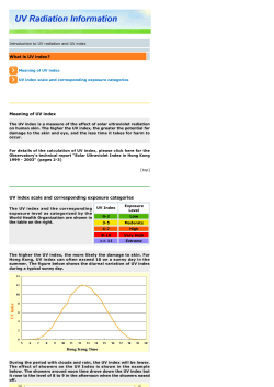


© Copyright 2026