
COVER SHEET
COVER SHEET
FEDERAL ENERGY REGULATORY COMMISSION
FINAL ENVIRONMENTAL IMPACT STATEMENT FOR THE
UPPER NORTH FORK FEATHER RIVER PROJECT
Project No. 2105-089
SECTION 5
STAFF’S CONCLUSIONS
PAGES 5-1 to 5-68
FEIS
5.0
5.1
STAFF’S CONCLUSIONS
COMPREHENSIVE DEVELOPMENT AND RECOMMENDED
ALTERNATIVE
Sections 4(e) and 10(a) of the FPA require the Commission to give equal
consideration to all uses of the waterway on which a project is located. When we review
a hydropower project, we consider the water quality, fish and wildlife, recreational, and
other non-developmental values of the involved waterway equally with its electric energy
and other developmental values. Accordingly, any license issued shall be best adapted to
a comprehensive plan for developing a waterway or waterways for all beneficial public
uses.
This section contains the basis for, and a summary of, our recommendations to the
Commission for relicensing the UNFFR Project. We weigh the costs and benefits of our
recommended alternative against other proposed measures.
5.1.1 Staff’s Modifications to PG&E’s Proposal
We developed the staff’s alternative after evaluating PG&E’s proposal and
recommendations and comments from resource agencies and other interested parties and
individuals. As a result, there were a number of proposed measures that were either
modified or not included in the staff alternative.
In its license application, PG&E proposed to use the upper-level gates in the
Canyon dam outlet tower for releases to the Seneca bypassed reach beginning on
September 15 and continuing until at least November 1. However, in its rehabilitation
plan for the Canyon dam outlet tower (PG&E, 2004c) it proposed using these upper-level
gates from September 1 to October 15. We slightly modified this measure by
recommending that a plan be developed to address the timing of use of the gates. Our
recommended plan would rectify this inconsistency, while considering the potential
effects on temperatures, odors and metals in the Seneca reach. Additionally, in its license
application, PG&E proposed to continue to comply with measures protecting bald eagles
according to existing nesting territory plans. Instead, we have recommended that PG&E
develop an interagency bald eagle management plan in consultation with the FS, FWS,
and CDFG to address project-related activities, especially those associated with a new
license for the project. Our recommended plan would enable responses to conditions that
arise during the term of a new license, some of which may not be foreseeable at this time
(e.g., establishment of new nests within or adjacent to the project area, changes in
recreational use patterns, changes in the bald eagle recovery plan, new management
guidelines based on future research results), to be effectively addressed, rather than
relying on existing plans.
5-1
The FS specified many of the SA measures in its final Section 4(e) conditions.
We recommend that most of the terms of the SA be approved and made conditions of the
license to be issued for the UNFFR Project. However, a specific Section 4(e) condition
(and SA measure) that we do not include in the staff alternative is the funding for a river
ranger position. We conclude that this should be the responsibility of the FS and/or
Plumas County because the primary responsibility of this position would be for law
enforcement, which is the responsibility of these agencies. We also recommend
modifications to some of the measures PG&E proposed in the SA for reasons discussed
in section 3.0, Environmental Analysis. Specific measures that we have modified,
including five that are also FS Section 4(e) conditions, are listed below:
x Monitoring fish and benthic macroinvertebrates in the Belden and Seneca
reaches: PG&E proposes and the FS specifies initiating monitoring between
10 and 12 years after license issuance, with sampling occurring every 2 years
over a 6-year period, for a total of three sampling periods; we recommend
initiating this monitoring during years 4 and 5 of the new license and then
monitoring every fifth year. We recommend this modification because we are
concerned that changes, negative or positive, to the fish, amphibian, and
macroinvertebrate communities would not be evident in a timely manner under
the monitoring program proposed by PG&E and specified by the FS.
x Pulse flows from Canyon and Belden dams: PG&E proposes and the FS
specifies providing one pulse flow release from both Canyon dam and Belden
dam in January, February, and March if the forecasted water year type for that
month indicates that the water year is anticipated to be either normal or wet (no
pulse flows are proposed in any of those months if the forecasted water year
type is dry or critically dry); in addition to the pulse flows proposed by PG&E
and specified by the FS, we recommend providing a pulse flow of 700 cfs
below Canyon dam and Belden dam in March of dry years, unless the water
temperature exceeds 10°C for two consecutive days in March and if a flow of
this magnitude was not measured in the preceding January or February at NF4
(Seneca) and NF7 (Belden). We recommend this modification to ensure that
periodic flows of the magnitude necessary to flush fine substrates from
spawning gravels, redistribute small gravels, and activate floodplain habitat
would occur with enough frequency to improve conditions for the aquatic biota
in the bypassed reaches, especially during periods of drought.
x Gravel monitoring plan: PG&E proposes and the FS specifies developing and
implementing a gravel monitoring plan to evaluate the movement of sediment
that occurs in the Belden and Seneca reaches during scheduled pulse flow
events and other flow events of similar magnitude; we recommend that the
gravel monitoring plan include specific contingency actions for the
enhancement of substrate distribution and abundance in the bypassed reaches.
5-2
We recommend this modification to facilitate corrective measures in case that
monitoring shows that the recommended pulse flow schedule should be
modified to improve the abundance and distribution of spawning-sized gravels,
or that gravel supplementation or vegetation management is needed..
x Recreation flow implementation plan: PG&E proposes and the FS specifies
implementing the recreation flow implementation plan, including test flows
and monitoring, in the Belden reach, in year 1 of the license; we recommend
delaying implementation of the plan until year 6. We recommend this
modification because it provides an opportunity for the biotic community to
adapt to the revised instream flow schedule without being disrupted by
recreational release flows, which would improve the likelihood of enhancing
macroinvertebrate and fish populations.
x Scheduled recreation flow releases: PG&E proposes and the FS specifies
releasing recreation flows in the Belden reach beginning in year 4 of the
license, following implementation of the recreation flow implementation plan;
we recommend delaying the recreation flow releases in the Belden reach until
year 9, also following the implementation of the recreation flow
implementation plan.
x Lake Almanor water quality monitoring: PG&E proposes monitoring once
every 5 years beginning in year 3 from license issuance; we recommend
monitoring only in years 1 to 3.
x Bioaccumulation (methylmercury and PCBs) monitoring in catchable-sized
fish: PG&E proposes monitoring once every 5 years beginning in year 1 from
license issuance; we recommend monitoring only in years 5, 10, and 15.
PG&E also proposes monitoring for bioaccumulation of silver; we do not
recommend monitoring for bioaccumulation of silver because previous
sampling indicates that silver body burdens are low, silver does not typically
biomagnify, and we are not aware of an established action or screening level
that represents the risk to human health.
x Bacteriological monitoring: PG&E proposes monitoring in years 1 to 5 from
license issuance, then every other year; we recommend monitoring only in
years 1 to 3.
x Cadmium and specific conductance monitoring: PG&E proposes monitoring
in years 1 and 2 from license issuance, at a minimum; we recommend
monitoring for up to 3 years in years 1 to 3.
x Monitoring the effectiveness of seasonal switching of the Canyon dam outlet
tower gates: PG&E proposes monitoring for 6 water years (not necessarily
5-3
consecutive) beginning in year 1 from license issuance; we recommend
monitoring only in years 1 to 3, only if those 3 water years are normal, dry, or
critically dry.
x Shoreline management plan: PG&E proposes implementing the shoreline
management plan included in the license application; the FS specifies and we
recommend revising the shoreline management plan prior to implementation.
Additional measures not proposed by PG&E that we recommend include (1) a
spoil disposal plan; (2) a water level and flow gaging plan; (3) a woody debris
management plan; (4) an adaptive management plan for environmental resources; (5) a
vegetation and invasive weed management plan; (6) expanding the amphibian plan to
address the federally threatened CRLF; (7) a threatened, endangered, proposed for listing,
and sensitive species protection plan; (8) a peregrine falcon monitoring plan; (9) a road
management plan; and (10) a fire prevention, response, and investigation plan. Staff’s
alternative would provide the following benefits over PG&E’s proposed measures: (1)
greater aquatic habitat enhancement; (2) tracking of population trends of special-status
species and, if necessary, adaptive adjustments made to project operations; and (3)
monitoring of project-related features to identify the need for remedial measures and
ensure that protective measures are functioning as planned.
5.1.2 Other Measures Not Included in Staff’s Alternative
While not proposed for the UNFFR Project, as part of the SA for the Rock CreekCresta Project, PG&E agreed to evaluate the effectiveness of modifying the project’s
Prattville intake as a temperature control measure for the downstream reaches of the
UNFFR. Based on our analysis in the EIS, summarized in section 5.1.4.1 below, we do
not include any provisions for modifying the Prattville intake in staff’s alternative.
On March 14, 2005, NOAA Fisheries submitted a modified Section 18 fishway
prescription for the UNFFR Project to the Commission. Based on our analysis in the
EIS, summarized in section 5.1.4.2 below, we do not include this prescription in staff’s
alternative.
5.1.3 No-action Alternative
The no-action alternative would result in the project continuing to operate as it is
currently operated. The environmental protection and enhancement measures proposed
by PG&E and recommended by staff would not be implemented.
5.1.4 Recommended Alternative
Based on our independent review and evaluation of the proposed project, the
proposed project with our additional recommended environmental measures, and the noaction alternative, we select the staff’s alternative (proposed project with our additional
5-4
recommended environmental measures) as the preferred alternative. The staff’s
alternative includes elements of the FS final Section 4(e) conditions, PG&E’s proposed
measures in its license application and in the SA, and some additional staff-recommended
measures.
We recommend this alternative because (1) issuance of a new license would allow
PG&E to continue to operate the project as a dependable source of electric energy for its
customers; (2) the 342.6-MW project would avoid the need for an equivalent amount of
fossil-fuel fired electric generation and capacity, continuing to help conserve these
nonrenewable energy resources while reducing atmospheric pollution; and (3) the
recommended environmental measures would protect or enhance fish and terrestrial
resources, improve public use of recreational facilities and resources, and maintain and
protect historic and archaeological resources within the area affected by project
operations.
We evaluated numerous recommendations from resource agencies and other
parties along with other potential measures considered by PG&E (to provide cooler water
downstream at its Rock Creek-Cresta Project) in the resource sections and, after
consideration of the environmental benefits and associated costs, we recommend
including the following measures that PG&E proposes in staff’s alternative for any
license issued by the Commission for the UNFFR Project:
1.
Use the upper-level gates in the Canyon dam outlet tower for releases to the
Seneca reach beginning in September and continuing until at least midOctober.
2.
Continue to implement the road maintenance agreement between PG&E
and the Plumas National Forest as it pertains to project roads on FS lands
within the project boundary.
3.
Operate and maintain the existing gages to determine river stage and
minimum streamflow below Canyon dam (NF-2) and Belden forebay dam
(NF-70) under the supervision of the USGS. Within 3 years of license
issuance, complete any modification to the two gage facilities that may be
necessary to measure the new minimum streamflow releases.
4.
Prepare annual water quality report(s) that contain elements consistent with
reporting requirements from five water quality programs, and provide the
report(s) to the Commission and appropriate resource agencies by no later
than March 15 of the following year. Convene a discussion group meeting
once annually between April 15 and April 28 that is noticed at least 30 days
in advance.
5.
Within 3 months of license issuance, develop a monitoring plan to evaluate
the effectiveness of seasonal switching of releases from the Canyon dam
outlet tower gates. This plan would be developed after consultation with
5-5
SWRCB, CVRWQCB, Plumas County, the FS, CDFG, and FWS. The plan
would identify analytical methods to be used, sampling protocols and
locations, QA/QC procedures, schedule, and reporting requirements.
6.
Within 3 months of license issuance, develop a monitoring plan to
determine if the elevated dissolved cadmium and specific conductance
levels recorded within the UNFFR basin during 2002 and 2003 were caused
by the project and, if so, potential remedial measures. The plan would be
developed after consultation with SWRCB, CVRWQCB, Plumas County,
the FS, CDFG, and FWS. The plan would identify analytical methods to be
used, sampling protocols and locations, QA/QC procedures, schedule, and
reporting requirements. Monitoring would be conducted during years 1 and
2 after license issuance, at a minimum.
7.
Within 3 months of license issuance, develop a monitoring plan to
document water quality conditions in Lake Almanor under altered project
operations for the new license. This plan would monitor analytes
seasonally (spring, summer, and fall) and would be developed through
consultation with the SWRCB and the signatories of the SA; and identify
analytical methods to be used, sampling protocols and locations, QA/QC
procedures, schedule, and reporting requirements.
8.
Within 3 months of license issuance, develop a monitoring plan to assess
potential bioaccumulation of methylmercury and PCBs in catchable-sized
fish in UNFFR Project waters. This plan would be developed after
consultation with SWRCB, CVRWQCB, Plumas County, the FS, CDFG,
and FWS; and identify analytical methods to be used, sampling protocols
and locations, QA/QC procedures, schedule, and reporting requirements.
9.
Within 3 months of license issuance, develop a bacteriological monitoring
plan, using a methodology appropriate to determine compliance with state
water quality standards. This plan would be developed after consultation
with SWRCB, CVRWQCB, Plumas County, the FS, CDFG, and FWS, and
identify analytical methods to be used, sampling protocols and locations,
QA/QC procedures, schedule, and reporting requirements.
10.
Provide minimum streamflows to the Seneca and Belden reaches, as
measured at gages NF-2 and NF-70, respectively, as PG&E proposes in the
SA (see tables 3-17 and 3-18). The minimum streamflows would
commence within 60 days of the issuance of the new license, unless PG&E
and/or the Commission determine that facility modifications are required.
11.
Maintain existing streamflow in lower Butt Creek. No action would be
taken to reduce dam leakage, tunnel leakage, spring or other natural flows
that currently provide inflow to lower Butt Creek below the Butt Valley
5-6
dam, unless directed to do so by the Commission or other regulatory
agencies.
12.
Provide one pulse flow release from both Canyon dam (Seneca reach) and
Belden dam (Belden reach) in each of January, February, and March if the
forecasted water year type for that month indicates that the water year is
anticipated to be either normal or wet. No pulse flows would be required in
months where the water year type forecast for that month indicates that the
water year would be critically dry.
13.
Develop a monitoring plan to evaluate movement of sediment that occurs
during scheduled pulse flow events and other flows of a similar magnitude.
Emphasis would be placed on monitoring the movement of spawning-sized
gravel and recruitment of similar-sized materials into the Belden and
Seneca reaches. This plan would be developed after consultation with the
FS, FWS, SWRCB, and CDFG. If it is determined that the pulse flows
appear to have a detrimental effect on the availability and distribution of
spawning-sized gravel, or it appears that a pulse flow of a different
magnitude or duration would be beneficial, the pulse flow schedule would
be altered to achieve the desired results.
14.
Implement a ramping rate of 0.5 foot per hour, in all months, at Canyon
dam, measured at gage NF-2, and Belden dam, measured at gage NF-70,
when ramping rate can be controlled. The ramping rate would not apply to
releases from project powerhouses or unregulated spills from project dams.
In the event that studies or monitoring that may be required during the term
of the license result in changes to the ramping rate, the new ramping rates
would not result in an increase in the total volume of water that is released
when the new ramping rates are applied.
15.
Block load (i.e., maintain a constant generating load for a predetermined
period) at the Belden powerhouse at times when the downstream Rock
Creek dam is spilling water in excess of the minimum streamflow required
under the license for the Rock Creek-Cresta Project, but less than 3,000 cfs.
Block loading would assist in minimizing the frequency of fluctuation in
the river stage and help meet ramping rates at downstream PG&E dams.
16.
Rehabilitate and maintain an existing streamflow gaging station on lower
Butt Creek designated as NF-9. An approximate rating curve would be
maintained with periodic spot checks and re-rating, as necessary. The gage
and the data collected on the gage would not be required to meet USGS
standards. The gage would be read each year on or about April 1, June 1,
August 1, and October 1.
17.
Develop a monitoring plan in lower Butt Creek to (1) determine if the weir
for gage NF-9 is acting to block upstream fish passage, and (2) evaluate
5-7
habitat quality at intervals of 3 to 5 years. This plan would be developed
following consultation with the FS, FWS, SWRCB, and CDFG. If it is
found that the weir is blocking upstream fish passage, remove or modify the
weir within 1 year of the determination. If monitoring indicates that habitat
quality in lower Butt Creek has been degraded, or if that habitat quality
could be improved over existing conditions, a pulse flow regime would be
developed in conjunction with the FS, FWS, CDFG, and SWRCB.
28
18.
As part of the recreational flow implementation plan, develop a monitoring
plan in the Belden reach for aquatic biota during the 3-year recreational
flow release test period. Monitoring would include an analysis of the
response of fish, benthic macroinvertebrates, and amphibians to recreational
flow releases at a minimum three sites. Monitoring would include an
analysis of stranding, displacement, disruption of spawning behavior and
habitat, and all other noticeable effects associated with release flows. In
addition, develop a recreational activities monitoring plan to assess the
effects of boating, camping, access, angling, and recreational flow releases
on fish and wildlife resources. These plans would be developed in
consultation with the FS, FWS, NPS, SWRCB, and CDFG.
19.
Maintain Lake Almanor water levels (PG&E datum) as follows:
̛
Wet and Normal Water Years—By May 31, the water surface
elevation would be at or above 4,485.0 feet (908,000 acre-feet) and
from June 1 through August 31, at or above 4,485.0 feet (908,000
acre-feet);
̛
Dry Water Years—By May 31, the water surface elevation would be
at or above 4,483.0 feet (859,000 acre-feet) and from June 1 through
August 31, at or above 4,480.0 feet (787,000 acre-feet);
̛
Critically Dry Water Years—By May 31, the water surface elevation
would be at or above 4,482.0 feet (835,000 acre-feet) and from June
1 through August 31, the water surface elevation is at or above
4,480.0 feet (787,000 acre-feet); and
̛
Multiple Dry Water Years—In the event of multiple (two or more),
sequential dry or critically dry water years, decreases in Lake
Almanor surface water elevations below those specified above
would be allowed.28 By March 10 of the second or subsequent dry
or critically dry water year and the year following the end of a
sequence of dry or critically dry water years, notify CDFG, FWS,
Similar deviations from the current minimum elevations specified for the Butt Valley
and Belden reservoirs also would be permitted.
5-8
SWRCB, FS, and Plumas County of drought concerns. By May 1 of
these same years, consult with representatives from CDFG, FWS,
SWRCB, FS, and Plumas County to discuss operational plans to
manage the drought conditions.
20.
Take such reasonable actions as may be prudent to prevent the water
surface elevation in Lake Almanor from exceeding elevation 4,494.0 feet
unless a higher level is approved by the Commission and CDWR, Division
of Safety of Dams.
21.
Continue to operate Butt Valley reservoir so that the minimum water
surface elevation from June 1 through September 30 is at or above 4,120.0
feet (32,000 acre-feet) and from October 1 through May 31 at or above
4,115.0 feet (24,500 acre-feet).
22.
Continue to operate Belden reservoir so that the minimum water surface
elevation is 2905.0 feet (300 acre-feet), year round.
23.
Forecast the water year type on or about January 10; notify the FS, CDFG,
FWS, SWRCB, and Plumas County within 15 days; and operate for the
remainder of that month and until the next forecast, based on that January
forecast. New forecasts would be made on or about the tenth of February,
March, April, and May, after snow surveys are completed, and operations
would be changed as appropriate. The May forecast would be used to
establish the water year type for the remaining months of the year and until
next January 10, when forecasting should begin again.
24.
Remove the Gansner Bar fish barrier on the Belden reach.
25.
Design a wildlife habitat enhancement plan, within 1 year of license
issuance, to be developed after consultation with the FS, FWS, CDFG,
SWRCB, and Plumas County, that would benefit sensitive biological
resources at the UNFFR Project. The plan would also include measures to
evaluate the response of riparian vegetation along the two bypassed reaches
to the proposed flow regime.
26.
Develop an amphibian monitoring plan for FS-sensitive species for the
Seneca, Butt Creek, and Belden bypassed reaches and submit to the
Commission within 1 year of license issuance. The plan would be
developed after consultation with the FS, FWS, SWRCB, and CDFG, and
would provide for monitoring conducted at 3-year intervals beginning no
later than 3 years following license issuance.
27.
Finalize a RRMP for the project that includes the following elements:
̛
A recreation facilities development program that defines proposed
responsibilities related to construction, including details of proposed
recreation development projects, estimated costs, and schedules;
5-9
̛
A recreation O&M program that defines proposed existing and
future recreation O&M responsibilities, including annual
maintenance costs and maintenance standards to be used;
̛
An I&E program that describes how hydroelectric energy
production, environmental, cultural, and informational I&E would
be coordinated and conducted at project facilities;
̛
A recreation monitoring program that identifies the frequency at
which the various recreational resource monitoring activities would
be conducted, including monitoring standards and indicators and
how the monitoring information would be used in decision-making;
̛
A resource integration and coordination program that defines how
recreation resource needs would be integrated with other resource
management needs over time, such as cultural, wildlife, and aquatic
resources and discusses how actions would be coordinated through
annual meetings; and
̛
A RRMP review and revision program that defines how the RRMP
would be updated or revised over the term of any new license and
limits updates to the RRMP to no more than once every 12 years.
The RRMP would be finalized in consultation with Plumas County,
the FS, CDFG, Interior, and the U.S. Army Corps of Engineers
within 1 year of license issuance.
28.
Implement the following recreational facility enhancement measures (part
of the recreation facilities development program) after initial license
issuance and during the license term based on target completion dates and
monitoring triggers (standards) included in the RRMP.
Lake Almanor Recreational Facilities and Access
̛
Last Chance Family and Group Campground—In accordance
with ADA, modify two campsites and existing toilet buildings and
provide a 150-foot access route leading to the nearby creek within 1
to 3 years after license issuance.
̛
Rocky Point Campground and Day-Use Area—Within 5 to 10
years after license issuance, convert the Loop 3 overflow camping
area into a day-use swim area containing an approximately 1-acre
sand beach above the high water level (4,494 feet elevation, PG&E
datum), provide a swimming delineator, a paved parking area to
accommodate 35 to 40 vehicles, and a double vaulted restroom;
relocate the 20 Loop 3 overflow campsites to the Loop 1 camp
overflow area and provide a new double vaulted toilet building at
5-10
this location; provide a new entrance kiosk at the campground, three
fee-based shower facility buildings (one for each loop) with hot
water, and bear-proof food lockers at each campsite (151); replace
older Klamath stoves with campfire rings; and revegetate or harden
areas significantly disturbed by pedestrian or vehicle traffic.
Implement the following accessibility improvements in accordance
with the ADA: modify 10 campsites (four at Loop 1, three at Loop
2, and three at Loop 3); create an accessible access route to the high
water level (4,494-foot elevation, PG&E datum) at the sandy beach;
make improvements to existing recreation facilities as needed, such
as the campground library box, telephones, and the envelope box at
the pay station and provide appropriate ADA-accessible access
routes; modify existing water faucets near accessible elements, such
as toilets and campsites, to be ADA-accessible; create accessible
routes to the toilet buildings near the campground entrance and near
campsite # 100); and relocate the interior pay station directly across
the road on a level, firm, and stable surface (Loop 2).
̛
Forest Service Almanor Shoreline Facilities—Within 1 to 13
years after license issuance, partner with the FS and provide
approximately 40 percent of matching funding up to a maximum of
$5,000,000 (2004 dollars) for the FS to complete recreation
improvements, including reconstruction of existing facilities and
construction of new facilities, at the following FS-owned recreation
facilities: the Almanor Family Campground, the Almanor Group
Campground, the Almanor amphitheater, the Almanor picnic area,
and the Almanor beach. If PG&E has not paid the FS the maximum
$5,000,000 (2004 dollars) at the end of the thirteenth year after the
license is issued because the FS has been unable to obtain its
corresponding share of the matching funds, then use the remaining
funds (the difference between the amount PG&E has already paid
the FS in matching funds and the $5,000,000 cap [2004 dollars]) for
recreation improvements at the Almanor beach and the East Shore
family campground, which would include the addition of up to 28
campsites in a third loop as funding permits.
̛
East Shore Group Camp Area—Within 1 to 3 years after license
issuance, convert the existing East Shore picnic area to a group
reservation camp area that will accommodate one group of 16 RVs
or two groups of eight RVs; widen the entrance road; improve
internal road circulation to accommodate RVs; provide one ADAaccessible parking space near the existing double-vaulted toilet
building and an ADA-accessible access route to the nearby trash
receptacles; provide bear-proof food lockers at 16 sites; provide a
5-11
paved, non-accessible trail down to the shoreline with switchbacks
and stairs; and institute erosion control measures.
̛
East Shore Day-Use Area—Within 1 to 5 years after license
issuance, designate a day-use swim area in the existing cove adjacent
to the proposed new East Shore campground which would include
up to five picnic tables, non-paved shoreline access trails, a single
vaulted toilet building, and parking for 10 to 20 vehicles.
̛
East Shore Family Campground—Over the term of the project
license period, contingent on reaching the recreation monitoring
standards contained in the RRMP during the new license term,
provide a new two-loop family campground on PG&E-owned land
along the east shore of Lake Almanor. Construct the campground in
two phases with a total of approximately 63 new tent and RV
campsites, bear-proof food lockers at each campsite, two user-fee
buildings with indoor hot showers and flush toilets, approximately
20 boat moorage slips/buoys, and a camp host site.
̛
North Shore Public Boat Launch—Within 3 to 5 years after
license issuance, provide a new and expanded public boat launching
facility at the North Shore campground, including paved parking for
40 single vehicles with trailers and 12 single vehicles, a double
vaulted toilet building, and a boarding float. Dredge and maintain
the existing submerged river channel to provide an approximately
1,000-foot-long, 50-foot-wide, and 6-foot-deep boat channel that
provides boat access to approximately the 4,480-foot elevation
(PG&E datum). The boat launch would be open for public use from
April 1 to December 1 when the lake’s elevation is at or above the
4,480 foot elevation (PG&E datum) and as snow on the ground
permits. Provide public access to the boat launch facility along an
abandoned portion of Highway 36 located along the north side of the
campground, in order to reduce traffic impacts at the campground.
Relocate 22 campsites within the project boundary that would be
affected by the expanded boat launch facility.
̛
Stover Ranch Day-Use Area—Within 3 to 5 years after license
issuance, develop the Stover Ranch day-use area to provide
improved Lake Almanor shoreline access for Chester residents,
including gravel parking for 10 to 20 vehicles, a double-vaulted
toilet building, four picnic tables, a non-paved trail to the shoreline,
an interpretive sign, and an RV site to accommodate a new Lake
Almanor caretaker. Coordinate these developments with the Chester
Public Utility District and the Chester Recreation and Parks District.
5-12
̛
Marvin Alexander Beach—Within 1 to 3 years after license
issuance, assume management responsibility of the PSEA swim
beach and expand and improve the existing sandy beach to a 0.4 acre
area above the high water level (4,494 foot elevation, PG&E datum),
provide an improved gravel parking area for 30 to 45 single vehicles,
replace the site's two single-vault toilet buildings and 10 picnic
tables, and provide a swim delineator. Change the name of the site
to the “Marvin Alexander Beach.”
̛
Canyon Dam Day-Use Area—Within 1 to 3 years after license
issuance, provide an approximately 0.3 acre sandy beach above the
high water level (4,494 foot elevation, PG&E datum), a swim area
delineator, an informational kiosk, improved vehicle circulation, and
eight new ADA-accessible picnic tables; and in accordance with
ADA, modify eight existing picnic tables to make them accessible,
provide an accessible parking space, and provide an accessible route
to the high water level (4,494 foot elevation, PG&E datum) at the
swim beach area in accordance with ADA. Reserve approximately
2.4 acres of land adjacent to the Canyon dam day-use area for
potential future recreation development during the term of the new
license.
̛
Westwood Beach Day-Use Area—Within 1 to 3 years after license
issuance, provide a gravel parking area for 10 vehicles, six picnic
tables, an ADA-accessible single vaulted toilet building, an
approximately 0.1 acre sandy beach, a swim delineator, directional
signage, and erosion control measures to protect the shoreline from
wind-caused wave action at the Westwood beach.
̛
Stumpy Beach Day-Use Area—Within 1 to 3 years after license
issuance, provide five picnic tables, directional signage, an
approximately 0.7 acre sandy beach above the high water level
(4,494 foot elevation, PG&E datum), a swim delineator, 8 to 10
paved parking spaces parallel to Highway 147 with trails connecting
to the northern and southern portions of Stumpy beach (the southern
trail would be ADA-accessible where feasible and the northern trail
would be non-paved), four benches at the roadside parking area for
viewing Lake Almanor and the surrounding mountains, and erosion
control measures to protect the shoreline from wind-caused wave
action. Provide a single vaulted toilet building if allowed by Plumas
County and the California Department of Transportation set-back
regulations; otherwise, provide a seasonal portable toilet building.
̛
Catfish Beach—Within 3 to 5 years after license issuance, make a
good faith effort to negotiate a reasonable easement across private
5-13
lands to provide public road access to the Catfish beach area.
Provide a single vaulted toilet building at this site and monitor and
maintain the toilet building and the site’s cleanliness through
appropriate means.
̛
Almanor Scenic Overlook—Within 1 to 5 years after license
issuance, provide an ADA-accessible route connecting the existing
ADA-accessible double vaulted toilet building at the overlook with a
new ADA-accessible parking space, and vegetative brushing and
clearing to restore the views of Lake Almanor, Mt. Lassen, and the
Canyon dam.
̛
Southwest Shoreline Access Zone—Within 1 to 5 years after
license issuance, provide four shoreline access points at existing
informally used areas along Lake Almanor’s southwest shoreline
between Prattville and Canyon dam after consultation with the FS.
These shoreline access areas would provide vehicle access at or
above the 4,494 foot elevation (PG&E datum) and serve as
pedestrian access areas to the adjacent shoreline. Provide four
gravel parking areas that provide parking for up to four to eight
vehicles at two of the areas and 10 to 20 vehicles at the other two
areas; vehicle barriers; regulatory, interpretive, and informational
signs; gravel access roads; and, if appropriate, single vaulted toilet
buildings at these access areas. Close and rehabilitate other usercreated vehicular access routes along the southwest shoreline after
consultation with the FS.
̛
Camp Connery Reservation Group Camp Area—Within 1 to 5
years after license issuance, provide an ADA-accessible parking
space and a new bunk house cabin with accessible toilet and fee
based hot shower and retrofit the existing telephone position and
water faucet features to meet the ADA. Over the term of the project
license period, contingent on reaching the recreation monitoring
standards contained in the RRMP during the new license term,
provide a new group reservation camping area adjacent to the
existing Camp Connery group camp, which would either provide
space for two groups of approximately eight self-contained RVs or
one group of approximately 16 self-contained RVs, a centrallylocated bear-proof food facility, and two user fee, indoor shower
buildings with hot water and flush toilets.
Butt Valley Reservoir Recreational Facilities and Access
̛
Powerhouse Trails—Within 5 to 10 years after license issuance,
provide improved angler access trails to two locations near the Butt
5-14
Valley powerhouse. One of the trails would be an approximately
200-foot, non-paved trail beginning at the existing gravel parking
area next to the powerhouse down the steep slope east of the
powerhouse to the levee below, with stairs, if needed. The second
trail would be ADA-accessible (compact base rock) originating from
an existing pullout along the Prattville-Butt Valley Road near the
powerhouse, extending approximately 700 feet to the eastern
shoreline of the inlet near the levee. Develop a new compacted base
rock trailhead parking area with barriers for this trail.
̛
Ponderosa Flat Campground—Within 5 to 10 years after license
issuance, provide a single person, non-heated outdoor shower at
Ponderosa Flat campground, and, in accordance with ADA; modify
four campsites and retrofit the existing designated accessible
campsites to provide accessibility of the picnic table, fire ring,
cooking grill, tent or RV area, and water faucet at each of these
campsites; replace the vault toilets in the overflow area with one new
accessible single vaulted toilet building and modify all of the other
existing designated accessible toilet buildings to meet current ADA
standards; provide an ADA-accessible access route to the toilet
building near Site 45 and one ADA-accessible paved parking space
near the toilet buildings; provide an ADA-accessible swimming area
at the campground with an approximately 0.4 acre sandy beach
above the high water elevation (4,132 foot elevation, PG&E datum)
and a swim delineator; and provide a new ADA-accessible fishing
access trail and pier or platform north of the overflow area. Over the
term of the project license period, contingent on reaching the
recreation monitoring standards contained in the RRMP during the
new license term, provide approximately 20 new primitive tent
campsites, likely to the north of the current overflow area, and a new
100 person capacity group camp area in the existing overflow area.
̛
Cool Springs Campground—Within 5 to 10 years after license
issuance, provide a two-person, non-heated outdoor shower at Cool
Springs Campground and one new ADA-accessible campsite with
elements including a picnic table, a fire ring, a cooking grill, a tent
or RV space, and water faucet.
̛
Alder Creek Boat Launch—Within 5 to 10 years after license
issuance, expand the existing Alder Creek boat launch parking area
to accommodate 10 to 20 additional vehicles with trailers and to
improve vehicle circulation. New parking areas on the east side of
the Butt Valley Reservoir Road would be gravel while the parking
areas on the west side of this road would be paved. Modify the boat
5-15
launch to be accessible, and provide one ADA-accessible parking
space near the existing double vaulted toilet building.
Belden Forebay Recreational Facilities and Access
̛
Belden Forebay Access—Within 5 to 10 years after license
issuance, provide a car-top boat launch, a seasonal portable toilet
building, and a gravel parking area for 10 single vehicles at the
Belden forebay's existing undeveloped parking area, which also
serves as the trailhead for the North Fork fishing trail; provide
suitable access for launching small car-top watercraft at the Belden
forebay; post signage referring to a Plumas County ordinance (once
the ordinance is approved) limiting boat engines to 10 hp, boat
speeds to 5 mph on small reservoirs such as the Belden forebay,
prohibiting swimming or boating within 0.25 mile of Belden dam
and prohibiting swimming or boating at night.
̛
North Fork Fishing Trail—Within 1 to 3 years after license
issuance, improve the North Fork fishing trail from the Belden
forebay parking area to the upstream side of Caribou No. 1
powerhouse, including retrofitting the existing metal trail decking
and railing at the powerhouse above the turbine outlets providing
enhanced access and safety, providing trail directional signs and a
wider, more even non-paved trail base along the chain-link fencing
at the powerhouse yard and along Caribou Road from the parking
area.
Recreational Facilities and Access in the Bypassed Reaches
̛
Upper Belden Reach River Access—Prior to the initiation of any
recreation release flows, provide a river access point at the upstream
end of the Belden reach located at the spoil pile area which would
include a seasonal portable toilet, a seasonal dumpster located over a
concrete pad, and a non-paved parking area to accommodate 15 to
25 single vehicles.
̛
Belden Reach Trails—Within 1 to 3 years after license issuance,
provide and maintain four trails to the Belden reach shoreline from
existing informal parking areas where public access can be provided
in a safe manner.
̛
Belden Rest Stop (SR 70)—Within 3 to 5 years after license
issuance, relocate the existing picnic tables down to the rest stop's
lower level and disperse them within the area from the Eby Stamp
Mill to the gazebo near the creek; replace two of the tables with
ADA-accessible tables; develop ADA-accessible routes to the
gazebo, the overlook area next to the creek, and to the Eby Stamp
5-16
Mill historical features; and provide improved I&E elements at the
rest stop and erosion control measures on the slope between the
parking lot and the upper picnic area. Remove the existing cooking
grills from the upper level and close that area. Over the term of the
project license period, replace the existing vault restrooms when
major renovation is needed. This improvement is contingent on the
monitoring triggers (standards) contained in the RRMP being
reached over the license term.
̛
Lower Belden Reach River Access—If a determination is made to
proceed with scheduled river recreation flows, provide up to a
maximum of $125,000 (2005 dollars) to the FS for construction of
non-project river access to the lower Belden reach.
29.
Assume responsibility for operational maintenance and heavy maintenance
of the following FS facilities prior to the start of the first recreation season
following license issuance: the Dyer View day-use area, the Canyon dam
boat launch and day-use area, and the Almanor boat launch. Additionally,
as each recreation facility is individually constructed, assume operational
maintenance and heavy maintenance responsibility for the southwest
shoreline access zone facilities. Finally, within 6 months after the FS has
completed construction of each of the recreation improvements it has
planned for the FS Almanor Family Campground and amphitheater, the FS
Almanor Group Campground, and the FS Almanor beach, apply to the
Commission to incorporate these additional FS facilities within the project
boundary and include these facilities in the O&M program.
30.
Develop an I&E program (part of the RRMP) for the project after
consultation with the FS and Plumas County within 2 years after license
issuance that provides information to enhance recreation experiences and
encourage appropriate resource protection, cooperative, and safe behaviors
from project visitors. The I&E program would include themes, media,
media design, prioritized sites, and prioritized services. As part of the I&E
program, prepare a Lake Almanor bathymetric (underwater topographic)
map within 1 year of license issuance, which would be available in
pamphlet form to area boaters and posted on signs at Lake Almanor public
boat ramps.
31.
Complete a recreation monitoring program (part of the RRMP) after
consultation with the FS and Plumas County, adopting the limits-ofacceptable change (LAC)-based monitoring approach as described in the
October 2002 draft of the RRMP. Specifically monitor (at a minimum) the
water surface of project reservoirs, and PG&E and FS recreation facilities
and shoreline areas within the project boundary. Prepare periodic
monitoring reports every 6 years in conjunction with FERC Form 80
5-17
recreation facility, and use monitoring requirements and conduct annual
recreation planning and coordination meetings with other recreation
providers in the project area to discuss recreation resource management
decisions for the project area, implementation of project recreation
enhancements, recreation monitoring results, potential grant applications,
and other pertinent project-related recreation issues that may arise over the
term of the new project license. If test river recreation flows are conducted,
develop a study plan to monitor recreation use during the test flow period
and produce a report on monitoring results after consultation with the FS.
32.
Stock approximately 5,000 pounds of catchable trout per calendar year in
the waters of the NFFR between its confluence with the EBNFFR and the
Belden diversion dam and augment CDFG’s existing Lake Almanor
fisheries program by expanding the pen rearing program and/or
constructing rearing habitat for warmwater fish.
33.
Coordinate with the FS, Plumas County, and CalTrans to develop an MOU
to produce a Belden interagency recreation river flow management plan that
would address management and integration of recreation opportunities
provided by the Belden recreation river flow release with other recreation
opportunities in the watershed.
34.
Establish a recreation river flow TRG for the purpose of consulting with
PG&E in the design of recreation and resource river flow management and
monitoring plans, reviewing and evaluating recreation and resource data,
and in developing possible recreation river flows in the Belden reach.
Include representatives of the FS, CDFG, SWRCB, FWS, NPS, and Plumas
County in the TRG. Maintain, and make public, records of TRG meetings,
and forward those records with any recommendations to the FS, SWRCB,
and the Commission. Establish communication protocols after consultation
with the TRG to facilitate interaction among TRG members, which would
allow for open participation, consultation with independent technical
experts, and communication among all TRG participants.
35.
Implement the recreation flow implementation plan as described in the SA
including:
̛
Convene the Technical Review Group (TRG) to evaluate the
existing available ecological information regarding recreation river
flows to determine whether (1) sufficient information exists to
conclude that recreation river flows would result in unacceptable
impacts on sociological or ecological resources; or (2) recreation
river test flows as prescribed should be conducted to further evaluate
the ecological and social effects of the recreation river flows in the
Belden reach. If the TRG determines that recreation test flows
5-18
should be conducted, it would not recommend any flow schedule
that exceeds the frequency, magnitude, or duration of flows
prescribed in the SA. Within 6 months of convening the TRG,
forward the TRG recommendations regarding recreation test river
flows to the FS and SWRCB.
36.
̛
If the TRG recommends that recreation test river flows in the Belden
reach should be conducted, the FS and SWRCB would consult with
appropriate state and federal agencies, PG&E, and tribal
governments about the TRG’s proposal. If the proposed schedule
for recreation test river flows does not exceed the frequency,
magnitude, or duration of flows prescribed for any given month in
the SA, then PG&E would submit the proposal to the Commission
for approval.
̛
Conduct the river recreation test flows upon approval from the
Commission as prescribed in the SA for a 3-year period.
̛
Prepare a Belden reach recreation river test flow evaluation plan and
submit it to the FS and SWRCB for their review, consistent with the
TRG recommendation. The plan would be designed to evaluate the
effects of the recreation test river flow releases on ecological and
social resources, and the metrics to be used in this determination.
Upon approval of the plan by the Commission, implement the plan
during the 3-year recreation test flow period.
̛
Convene the TRG after the 3-year recreation test river flow period to
evaluate the existing available ecological and social information.
The TRG would make a recommendation whether recreation river
flows should be continued to meet the river flow management for
recreation objectives. The TRG would not recommend any flow
schedule that exceeds the frequency, magnitude, or duration of flows
prescribed in the SA.
̛
Submit any recommendation regarding continued recreation river
flows made by the TRG to the FS and SWRCB for review. The FS
and SWRCB would consult with FWS, PG&E, and tribal
governments during their review. If the proposed schedule for
continued recreation river flows that does not exceed the frequency,
magnitude, or duration of the flows prescribed for any given month
in the SA, PG&E would submit the proposal to the Commission for
approval.
Post, through a third party or other mechanism, an annual recreation flow
calendar scheduling the initial recreation flow day per month.
5-19
37.
Conduct an annual planning meeting each year in March to discuss
expected water year type, results of monitoring efforts, PG&E maintenance
needs that may conflict with recreation flow releases, and other relevant
issues. Suggest that the TRG recommend the desired date of the month for
any additional recreation river flow release days triggered by the number of
boats per day as described below, based on evaluation of social and
ecological considerations.
38.
Postpone any scheduled recreation river flow release in the event of an
emergency, providing as much notice as reasonably practicable under the
circumstances. If practicable, reschedule postponed recreation river flow
releases as recommended by the TRG.
39.
During scheduled recreation river flows, count observed boater use in
number of boats per day to determine whether recreation flow release days
should be added or subtracted. All boats would be counted as one boat
except for rafts 12 feet or greater in length which would be counted as two
boats. All boats observed on the Belden reach for any part of a given day
would be counted. If the number of boats per day on the first recreation
river flow day for a month exceeds 100 boats per day, one day of recreation
river flow would be added to the recreation river flow schedule in that
month the next year. If the number of boats per day is less than 100 boats
per day for both the recreation river flow releases in one month, one day of
recreation river flow would be subtracted from the recreation river flow
schedule for the that month in the next year. Recreation river flow releases
would not decrease below one day per month and would not exceed the cap
defined in the SA. Recreation river flow release days would not be added
or subtracted during any period of recreation test river flows.
40.
Develop and implement a visitor survey for up to 3 years to determine if
visitors would choose to return to recreate on the Belden reach based on
their experience related to the number of boats encountered on the river.
The visitor survey questionnaire and methodology would be statistically
valid. The TRG would evaluate the survey results and other data to
determine if the trigger for adding/deleting days, based on the number of
boats per day, should be amended based on this analysis.
41.
Apply the basic ramping rates when implementing recreation river flows.
42.
Create a calendar that lists the dates of the March pulse flow in the Seneca
reach and any scheduled pulse flow or recreation river flow releases in the
Belden reach, and make that calendar available on the Internet through a
third party or other mechanism. The calendar would state the timing and
magnitude of the scheduled flow release. The March pulse flow release in
the Seneca reach would be posted by February 15, and the scheduled
summer releases in the Belden reach would be posted by May 15. Post an
5-20
estimate of the release magnitude and duration of the flow if releasing flows
of a similar magnitude and duration as a scheduled pulse flow in the Seneca
or Belden reaches.
43.
Meet annually with a committee appointed by the Plumas County Board of
Supervisors between March 15 and May 15 to inform the committee about
the water elevation levels of Lake Almanor predicted to occur between May
1 and September 30. Schedule an additional meeting with the committee if
forecasts show that PG&E’s obligation to deliver water to the state of
California and the Western Canal Water District pursuant to the January 17,
1986, agreement would require it to deviate from the Lake Almanor water
elevation levels previously predicted.
44.
Modify the project boundary to include approximately 34 additional acres
of the Plumas National Forest at Caribou powerhouse and Belden dam for
the purposes of penstock maintenance and spoil management.
45.
Apply to the Commission within 1 year of license issuance to adjust the
project boundary to include all recreation improvements covered by the SA
and associated roads at PG&E facilities including the East Shore
campground, group camp area, and day-use area, the Stover Ranch day-use
area, the Catfish Beach area, the Westwood Beach day-use area, the
Stumpy Beach day-use area, the Upper Belden Reach river access site, the
Belden reach trails, and those portions of the southwest shoreline access
zone facilities currently outside the project boundary as well as the
following FS facilities located on the Plumas and Lassen National Forests:
Canyon dam boat launch and day-use area, Dyer View day-use area, and
Almanor boat launch.
46.
Apply to the Commission to adjust the project boundary as needed to
incorporate the Almanor Family Campground and Amphitheater, the
Almanor Group Campground, and the Almanor beach, 6 months after the
FS has completed construction of all of the recreation improvements it has
planned for each of these facilities.
47.
File a road traffic survey plan for roads used for project purposes located on
NFS lands with the Commission within 1 year of license issuance which
includes provisions for monitoring traffic every 6 years when monitoring
recreation use in accordance with FERC Form 80 requirements. At a
minimum, the road traffic survey would include the Caribou Road (27N26)
and the Caribou-Butt Valley Reservoir roads (27N26 and (27N60) and
include the number and types of vehicles per day on these roads and a
sampling schedule that includes the fishing season, including the opening
weekend; holiday weekends including Memorial Day, Fourth of July, and
Labor Day; non-holiday weekends; the day of and the day after any
scheduled Belden reach recreation river flow releases; and weekdays.
5-21
Every 6 years, the road traffic reports would be reviewed by the FS and
then filed with the Commission.
48.
Implement the following measures within 2 years of license issuance:
̛
Paint the metal siding and roof of the hoist house on the Prattville
intake structure a dark green color similar to the current color;
̛
Plant sufficient evergreen trees between the existing Prattville
maintenance buildings and the shoreline to reduce visual domination
of the buildings on the shoreline area. Monitor and oversee the
survival of these trees through the first three summers to ensure
successful establishment;
̛
Re-grade the Oak Flat road debris spoil piles along Caribou Road to
create a more natural rolling topography along the roadside and
where possible move spoil materials farther from the road; and
̛
Establish native plantings where possible between the road and the
Oak Flat spoil piles to help screen the active use areas from passing
motorists.
49.
Within 2 years of license issuance, prepare a plan, after consultation with
the FS, to annually apply dust palliatives or other measures, including
regular grading, to help minimize dust emissions and improve the lower
coupled segment of the Butt Valley-Caribou Road.
50.
Consult with the FS on color selection when maintenance or repair work is
scheduled on the Belden powerhouse penstocks, surge chamber, or other
powerhouse facilities, to reduce visual contrast as seen from SR 70.
51.
Maintain the exterior and landscaping of the clubhouse, houses, and
grounds at Camp Caribou to preserve the historic features and character of
the facility. Consult with the FS when planning maintenance or repair
activities at this National Register eligible property.
52.
File a visual management plan with the Commission within 60 days prior to
any ground-disturbing activities on NFS lands. This plan will, at a
minimum, address clearings, spoil piles, and project facilities such as
diversion structures, penstocks, pipes, ditches, powerhouses, other
buildings, transmission lines, corridors and access roads; facility
configurations, alignments, building materials, colors, landscaping, and
screening; a proposed mitigation and implementation schedule necessary to
bring project facilities into compliance with the National Forest LRMP
direction; locating spoil piles either in approved areas on NFS lands or in a
location off of NFS lands; monitoring and eradication of noxious weeds as
specified in any noxious weed management plan for the project; removal of
all visible non-native materials, including construction debris from the
5-22
surfaces of piles located on NFS lands; and stabilization and revegetation of
all native material that is allowed to be left on NFS lands, including
compliance with visual quality objectives.
53.
Meet with the FS and Plumas County a minimum of every 10 years to
discuss the need to update the SMP. The need to update the SMP sooner
may also be raised and discussed during the annual land use meetings with
the FS and Plumas County.
54.
Conduct an annual meeting with the FS, CDFG, and Plumas County to
coordinate ongoing project related land management activities including
recreation management and use, fire suppression and related forest health
activities, and the planning for commercial, residential and industrial
developments.
55.
Finalize and implement the HPMP.
In addition to, or in lieu of, PG&E’s proposed measures, we recommend the
following additional resource measures based on our independent analysis (see section
3.0 of this EIS).
1.
Develop a plan, including the schedule, for using the Canyon dam outlet
upper-level gates to alleviate heavy metal concentrations and odors
associated with late-summer and fall releases from Canyon dam. This plan
would be developed after consultation with the SWRCB, CVRWQCB,
Plumas County, the FS, CDFG, and FWS. The plan would be filed with the
Commission within 3 months of license issuance.
2.
File with the Commission a spoil disposal plan within 6 months of issuance
of a new license and at least 60 days prior to any ground-disturbing or soil
producing or piling activity.
3.
Develop a water level and flow gaging plan. The plan would be developed
and filed with the Commission within 3 months of license issuance, and
implemented immediately upon approval. This plan would specify
monitoring locations, instrumentation, monitoring protocols, schedule, and
reporting requirements, including who the reports would be routed to.
Minimum requirements of the plan would include continued operation of
existing gages; monitoring of lower Butt Creek flows at or near station NF9
on or about April 1, June 1, August 1, and October 1; reporting of noncompliance conditions; and providing daily midnight Lake Almanor storage
and water surface elevations, delayed between approximately 1 and 2 days,
on the Internet through a third party or other mechanism.
4.
As part of the proposed plan to document the effectiveness of seasonal
switching of releases from Canyon dam outlet tower gates, seasonally
monitor water quality in Lake Almanor near the outlet tower and the Seneca
5-23
reach for the first 3 years after license issuance, only if those three water
years are normal, dry, or critically dry.
5.
As part of the proposed plan to document water quality in Lake Almanor
under altered project operations for the new license, seasonally monitor in
situ parameters, general analytes, minerals, metals, nutrients, petroleum
products, and Secchi depths in Lake Almanor annually for the first 3 years
after license issuance.
6.
As part of the plan to assess potential bioaccumulation of methylmercury
and PCBs in catchable-sized fish, collect and analyze samples in years 5,
10, and 15 following license issuance.
7.
As part of the bacteriological monitoring program, monitor fecal coliform
densities, using a sampling regime that will allow determination of
compliance with state standards, annually for the first 3 years after license
issuance.
8.
If the Commission reduces or terminates the current water temperature
monitoring requirements of the Rock Creek-Cresta Project Water
Temperature Management Plan for Project 2105 affected sites, develop a
plan to monitor DO concentrations in Lake Almanor and Butt Valley
reservoir. This plan would be developed after consultation with SWRCB,
the FS, CDFG, and FWS; and filed with the Commission within 3 months
of Commission approval of reduction or termination of the Rock CreekCresta Project Water Temperature Management Plan. This plan would
describe monitoring methods and locations, QA/QC procedures, the
monitoring schedule, and reporting requirements. The schedule would
ensure monitoring for at least 3 years following license issuance.
9.
If the Commission reduces or terminates the current water temperature
monitoring requirements of the Rock Creek-Cresta Project Water
Temperature Management Plan for Project 2105 affected sites, develop a
water temperature monitoring plan to document water temperatures
resulting from operating the project under a new license. The plan would
ensure monitoring for at least 3 years following license issuance.
10.
Provide a pulse flow release of 700 cfs in the Seneca reach and in the
Belden reach in March of water years classified as dry, unless the water
temperature exceeds 10°C for two consecutive days in March and if a flow
of this magnitude was not measured in the preceding January or February at
NF4 (Seneca) and NF7 (Belden).
11.
As part of the proposed gravel monitoring plan, develop specific
contingency actions for the enhancement of substrate distribution and
abundance in the bypassed reaches.
5-24
12.
Implement one mid-term geomorphological evaluation in project reaches to
assess the response of channel processes to the recommended flow
schedule.
13.
File the aquatic monitoring plan for the Seneca and Belden reaches with the
Commission within 1 year of license issuance. As part of the aquatic
monitoring plan, periodically monitor fish populations (in a manner
consistent with data presented in pre-filing study reports) and benthic
macroinvertebrates in the Seneca and Belden reaches, as proposed in the
SA, to determine the effects of measures included in the license, such as
minimum flow regimes, pulse flows, and ramping rates. Initiate monitoring
during years four and five of the new license to determine the biological
response to any measures and to establish a new baseline for detecting
biological responses to any modifications of measures. After this 2-year
monitoring period, the frequency of surveys would be reduced to every fifth
year to evaluate long-term responses to measures implemented in the new
license and any subsequent modifications that are made. A draft aquatic
monitoring plan would be distributed to the consulted agencies, who would
be allowed a minimum of 30 days to comment on the plan. Distribute the
results of each year’s monitoring to CDFG, SWRCB, the FS, FWS, and the
Commission.
14.
Develop a woody debris management plan after consultation with CDFG,
SWRCB, the FS, and FWS. The plan would be developed and filed with
the Commission within 1 year of license issuance. A draft plan would be
distributed to the consulted agencies which would be allowed a minimum
of 30 days to comment on the plan and would include measures to warn and
educate boater in the Belden reach about LWD obstacles in the riverine
corridors.
15.
Develop an adaptive management plan after consultation with CDFG,
SWRCB, the FS, and FWS to be filed with the Commission within 1 year
of license issuance. The plan would be designed to evaluate the effects of
environmental measures on all resource areas and to evaluate the need for
adjusting or implementing new measures to enhance environmental
resources affected by the project. The plan would also define the process
that would be used to determine whether or not there is a need to adjust
measures that may be specified in a new license or implement new
measures. The plan would also define consultation procedures that would
be taken prior to undertaking any actions that would affect FS sensitive
species or their habitat to determine whether preparation of a Biological
Evaluation would be necessary. A review would be conducted and reports
would be filed with the Commission every 5 years for the term of the
license.
5-25
16.
Delay implementation of recreational flow releases for a period of 6 years
to allow the riverine aquatic biota to respond to new minimum and pulse
flow schedules. In year 6 of the license, establish the recreation river flow
TRG and implement the recreation flow implementation plan, as described
in the SA. If a decision is made to continue recreation river flows
following a 3 year test period, implement the recreation river flow schedule
and other provisions as presented in the SA.
17.
Within 1 year of license issuance develop a vegetation and noxious weed
management plan for all project lands that provides for the following:
protection of special-status plants that includes maintenance of the project
GIS data base that would allow mapping and tracking occurrences of
special-status plants to assist in evaluating plans for vegetation
management, siting for new recreational facilities and considering other
activities that would cause ground disturbance or habitat alteration;
improvement of wildlife habitat, consulting with the FS to evaluate the
consistency with FS standards and guidelines for management of the NFS
lands, protection of listed and sensitive species; and control of noxious
weeds. Part of this plan would include a plan for the protection and
management of VELB habitat, including protection in the area around the
known location of the elderberry shrub and pre-activity surveys in areas
that would have vegetation clearing or cutting. PG&E would consult with
the FS and FWS on protection and management of VELB habitat and
ensure that measures identified in the plan (e.g., flagging and protecting
elderberry shrubs with stems over 1 inch in diameter) are consistent with
the current FWS guidelines (FWS, 1999, or subsequent update).
18.
As part of the wildlife habitat enhancement plan, include additional
monitoring of habitat for wading birds and waterbirds in the causeway area,
and incorporate management considerations outlined in the “Conservation
Assessment and Management Plan for Breeding Western and Clark’s
Grebes in California.”
19.
Develop a threatened, endangered, proposed for listing, and sensitive
species protection plan, within 1 year of license issuance, as part of the
biological and adaptive management plans for listed species. Consult with
the FS and FWS prior to undertaking any actions that would affect FS
sensitive species or their habitat, to determine whether preparation of a
biological evaluation is necessary; identify BMPs that are consistent with
FS standards and guidelines; and develop any specific protection measures
that should be implemented.
20.
As part of the amphibian monitoring plan, specify the process by which
additional potential CRLF habitat would be determined and potential
project-related effects identified. In addition, specify the consultation
5-26
process that would be implemented with FWS and other appropriate
agencies, should the presence of a CRLF be confirmed within projectaffected waters during monitoring, or based on credible information from
other sources. After year 15, meet with the FS, FWS, SWRCB, and CDFG
and determine the need, frequency, and locations of future monitoring
efforts.
21.
Develop a peregrine falcon monitoring plan within 1 year of license
issuance after consultation with the FS, FWS, and CDFG. This plan would
include provisions for monitoring of peregrine falcon nest territories in
accordance with measures found in FWS’ “Monitoring Plan for the
American Peregrine Falcon” completed in December 2003. Where
possible, this plan may be incorporated into the interagency bald eagle
management plan to avoid duplication of effort.
22.
Develop an interagency bald eagle management plan within 1 year of
license issuance after consultation with the FS, FWS, CDFG, private timber
companies (e.g., Collins Pine), and recreational groups (e.g., AW, Chico
Paddleheads, and Shasta Paddlers). This plan would include, for all project
lands and waters, at a minimum, provisions for (1) annual monitoring of
bald eagle reproductive success, distribution, and abundance; (2)
monitoring of human use patterns to determine human/eagle interactions;
(3) coordination of any plans for timber harvest, mining, and recreational
enhancements on PG&E lands influenced by the UNFFR Project with the
FS, FWS, and other consulting agencies; (4) protection and enhancement
measures within the management zones; and (5) steps to minimize eagle
disturbance resulting from proposed changes in project operations,
facilities, and recreational enhancements. Where possible, peregrine falcon
nest territory monitoring may be incorporated into the interagency bald
eagle management plan. At the discretion of the consulting agencies,
PG&E may incorporate portions of this plan with the FS’ “Bald Eagle
Management Plan, Lake Almanor and the Upper Feather River, Recovery
Zone 26, Lake Almanor Basin Area” completed in September 2003.
23.
Prior to implementation of the Lake Almanor SMP, revise the draft SMP
included in the final license application after consultation with SWRCB,
CDFG, the FS, Plumas County, and the Maidu community to determine
appropriate actions to take to evaluate the potential adverse effects of the
altered lake level conditions on other resources. Revisions to the draft SMP
would include addressing inconsistencies with county land-use
designations, as identified by Plumas County; reevaluation of shoreline
erosion at a few locations identified by Plumas County as having moderate
to severe erosion; and addressing evaluation of potential adverse effects of
shoreline erosion resulting from the altered lake level conditions on water
quality, aquatic resources, cultural resources, recreation, and aesthetics.
5-27
PG&E would file the revised SMP along with comments on it with the
Commission within 3 months of issuance of a new license.
24.
Within 1 year of license issuance, develop a road management plan for all
FS and unclassified roads on NFS lands needed for project access. The
road management plan will identify all FS and unclassified roads on NFS
lands needed for project access, including the road numbers; a map of all
FS roads and unclassified roads on NFS lands needed for project access,
including digital spatial data accurate to within 40 feet identifying each
road by FS road number, detailed descriptions of each FS road segment and
unclassified road on NFS land needed for project access; provisions for
PG&E to consult with the FS prior to any road construction, realignment or
closure involving FS roads or lands needed for project access; provisions
for PG&E to cooperate with the FS on the preparation of a condition survey
and a proposed maintenance plan annually, beginning the first full year
after the road management plan has been approved. The road management
plan will also specify that PG&E must obtain appropriate authorization
from the FS for all project access roads under FS jurisdiction outside of the
project boundary, including unclassified roads and FS system roads needed
for project access. The road management plan would identify PG&E’s
responsibility for road maintenance and repair costs commensurate with
PG&E’s use and project-induced use. Any roads identified as necessary for
operation of the project should be included within the project boundary.
25.
Develop a fire prevention, response, and investigation plan developed in
consultation with the FS and appropriate state and local fire agencies within
1 year of issuance of a new license that sets forth in detail the plan for
prevention, reporting, control, and extinguishing of fires in the vicinity of
the UNFFR Project.
26.
Implement the measures outlined in the PA.
27.
Provide Plumas County with copies of all requested cultural resources
reports, including the non-confidential volume of the ethnographic study, if
Plumas County agrees not to make the reports available to the public, in
compliance with Section 304 of the NHPA.
28.
Finalize the HPMP and include (1) the details of PG&E’s employee and
public education and interpretive program; (2) site-specific treatment
measures for historic archaeological sites and standing structures that
FERC, in consultation with the SHPO, has determined are eligible for the
National Register; (3) protocols for PG&E to consult and work with the
Greenville Rancheria, Susanville Indian Rancheria, and other interested
Maidu groups; (4) results of any consultations on a curation facility or
interpretive center; and (5) a discussion on the Cultural Resources Working
Group, including member entities and a schedule for future meetings.
5-28
Implementation of these measures, in addition to the measures proposed by
PG&E, would protect and enhance water quality, fisheries, terrestrial, recreational,
aesthetic, and cultural resources in the project area. We present our rationale for some of
our recommended measures in the following sections.
5.1.4.1
Water Resource Measures
Measures to Reduce Water Temperature
Water temperature data for the UNFFR Project area and the lower NFFR indicate
that summer daily mean water temperatures frequently exceed 20.0ºC and thereby
adversely affect the coldwater fishes in surface waters of Lake Almanor and Butt Valley
reservoir; Caribou powerhouse discharges; and the Belden, Rock Creek, Cresta, and Poe
reaches (see table 3-7). PG&E evaluated numerous potential measures to reduce water
temperatures in the Belden reach and the lower NFFR reaches. Although the primary
goal of many of these measures is to reduce temperatures in reaches downstream of the
UNFFR Project, because implementing some of them would necessitate modifying
UNFFR Project facilities and/or operations, we evaluate these measures in this EIS (see
Water Temperature and Dissolved Oxygen Management in section 3.3.1.2, Water
Quality, and appendix D).
Although the use of thermal curtains in Lake Almanor and/or Butt Valley reservoir
would reduce NFFR temperatures downstream of the Caribou powerhouses, we are
concerned about the extreme adverse effects that these measures would have on the
lakes’ coldwater fishery and other environmental, cultural, and recreational resources,
and the high cost. This also is the case for other Prattville intake modifications (see
appendix D) evaluated by PG&E. Operating the project with Prattville intake
modifications would have extreme ecological, social, and economical effects including:
x Adverse effects on the coldwater fishery of Lake Almanor (see section 3.3.2.2
of this EIS);
x Adverse effects on the existing trophy rainbow and brown trout fishery of Butt
Valley reservoir (see section 3.3.2.2 of this EIS);
x Adverse effects on boating safety on Lake Almanor (see section 3.3.5.2 of this
EIS);
x Elimination of public access and recreational use of approximately 16 acres of
Lake Almanor (see section 3.3.5.2 of this EIS);
x Adverse effects on viewsheds of Lake Almanor (see section 3.3.6.2 of this
EIS);
x Potential disturbance of Native American burial grounds associated with
dredging of the submerged levees, if the levees are removed (see section
3.3.7.2 of this EIS);
5-29
x Cost of between roughly $6,000,000 and $18,000,000 to modify the Prattville
intake depending on whether the levees are removed (Black & Veatch, 2004);
x Additional costs associated with operating and maintaining the floating curtain
throughout the term of any new license; and
x Adverse effects on the local economy of Chester and the region near Lake
Almanor (see section 3.3.8.2 of this EIS);
Studies also show that increasing Canyon dam releases and reducing withdrawals
through the Prattville intake and consequently discharges from the Butt Valley and
Caribou powerhouses would reduce temperatures in reaches of the NFFR. PG&E’s
proposed MIFs and use of the Canyon dam low-level gates would reduce temperatures in
the Belden reach and lower NFFR reaches, although daily mean temperatures of greater
than 20.0ºC would still occur throughout most of these reaches during July and August.
We estimate that implementing the proposed MIFs would decrease the net annual benefit
of the project by about $3,684,200.
Providing releases from Canyon dam higher than the proposed MIFs, while
reducing withdrawals through the Prattville intake, would further reduce temperatures in
the NFFR, although the incremental benefit would be smaller as flow releases are
increased. In addition, reducing discharges from the Butt Valley powerhouse would
increase Butt Valley reservoir temperatures and thus degrade its coldwater fishery. We
estimate that these releases (200-cfs to 400-cfs releases from the Canyon dam outlet lowlevel gates through Canyon dam instead of the Butt Valley powerhouse) would have an
average annual cost in lost generation to the project of approximately $1,800,000 more
than implementation of PG&E’s proposed MIFs. For these reasons, along with the
incremental decrease in the net annual benefit of the project, which would result from
reduced generation at the Butt Valley and Caribou powerhouses, we do not recommend
MIFs higher than those proposed by PG&E in the SA.
Water Quality Monitoring
Our review of PG&E’s water quality data, detailed in section 3.3.1.1, Water
Quality, indicates that project waters typically comply with the applicable federal and
state standards for most water quality parameters. However, available information
indicates that the applicable criteria for water temperature and DO are frequently not
satisfied in some areas, and it is questionable whether other water quality standards
including some trace metals are typically satisfied throughout project waters. Evidence
also indicates that trace metals and PCBs accumulate in fish and crayfish in the Belden
forebay and the NFFR downstream of the forebay.
Concentrations of dissolved cadmium in grab samples collected during 2002 and
2003 suggest that EPA’s National 4-day average hardness-based criteria may be
exceeded for the NFFR near Chester (NF1), Lake Almanor near Canyon dam surface
5-30
(LA1-S), and Butt Valley powerhouse tailrace (BV1) and specific conductance values
exceeded the Basin Plan criterion of 150 μmhos/cm at several stations on the NFFR and a
station in lower Butt Creek.
Under existing project operation, PG&E typically uses the Canyon dam outlet
tower low-level gates to supply the Seneca reach with cool water; however, these
operations have resulted in elevated odors and trace metal concentrations in the NFFR
downstream of Canyon dam, particularly in the fall prior to turnover of Lake Almanor.
Lake Almanor’s limnology could be influenced by operating the project to provide
for water surface elevations from June 1 through August 31 that are 10 feet higher than
current levels in wet and normal water year types and 5 feet higher in dry and critically
dry water year types. We conclude that it would be appropriate to monitor water quality
conditions in Lake Almanor for the first 3 years of any new license period to assess the
effects of changing project operation under any new license for this project. In this
manner, the effects of the new operations could be readily evaluated and corrective
actions, if necessary, could be made within a few years of implementing the new license
terms.
In the SA, PG&E proposes developing a water quality study and monitoring plan
that would incorporate five plans. These five plans, which we recommend with our
specific details, are (1) a plan to evaluate the adequacy and efficacy of mitigating
elevated odor and dissolved metal levels in the Seneca reach through seasonal gate
switching at the Canyon dam outlet; (2) a plan to identify the cause of high dissolved
cadmium and specific conductance levels in waters of the UNFFR that were measured in
2002-2003; (3) a water quality monitoring plan to monitor water quality conditions in
Lake Almanor; (4) a plan to monitor the potential bioaccumulation of total mercury and
PCBs in tissue samples collected from resident catchable-sized (minimum total length of
8 inches) fish in waters of the project in years 5, 10, and 15 following license issuance;
and (5) a bacteriological monitoring plan consistent with the Basin Plan objectives for
protection of the water contact recreation beneficial uses.
We estimate the annualized cost of developing and implementing these five
recommended water quality plans, together with the cost of producing the water quality
reports for the project, would be about $150,900. Because we recommend a more
abbreviated monitoring schedule than the one presented in the SA (we do not recommend
monitoring for the entire license term), the cost of our recommendations is $40,800 less
than the recommendations as presented in the SA.
5.1.4.2
Aquatic Resource Measures
Minimum Flows
The minimum flow regime proposed by PG&E in the SA calls for the release of
minimum flows, based on water year type, for the preservation and improvement of
5-31
aquatic resources in the Seneca and Belden reaches of the NFFR. The proposed flow
schedules allow for variable releases that range from 60 to 150 cfs into the Seneca reach
from Canyon dam, and variable releases that range from 75 to 235 cfs into the Belden
reach from the Belden dam. The releases are dependent on the month and water year
type (critically dry, dry, normal, and wet) and are designed to mimic the variability in
flow that would occur with a natural hydrograph. The highest flows would typically
occur during late winter and early spring, and the lowest flows would occur during late
summer and early fall. The minimum flow regime specified in the SA would enhance
aquatic habitat, including water temperature, for a number of key species and life stages,
while retaining the ability of anglers to effectively fish in both project bypassed reaches,
as discussed in section 3.3.2.
We estimate that implementing the minimum flow regime proposed in the SA
would decrease the net benefit of the project by about $3,684,200, due to the loss of
generation. An advantage of the SA’s flow shaping approach that is not evident in the
lost revenue and generation values is that, during the period of peak energy demand,
which is typically in July and August, the minimum flow requirements are near their
lowest levels. Consequently, more energy would be available at those times than would
be if a single higher year-round minimum flow regime was to be implemented in both of
the bypassed reaches. We consider the environmental benefits of implementing this flow
regime to be worth its cost.
In its Section 10(j) recommendation, Interior recommends that PG&E implement a
proposed flow schedule that allows for variable releases dependent on the month and
water year type. However, Interior recommends variable releases that range from 60 to
170 cfs into the Seneca reach from Canyon dam, and variable releases that range from
100 to 250 cfs into the Belden reach from the Belden dam. Interior’s recommended flow
regime, though providing somewhat higher flows during certain seasons for different
water year types, does not provide for a substantial increase in habitat suitability for the
evaluated species’ lifestages over the flow regime recommended in the SA, as discussed
in section 3.3.2. We estimate that implementing Interior’s flow regime would decrease
the net annual benefit of the project by $469,000 more than our recommended flow
regime, with little additional environmental benefit.
In the SA, PG&E commits to make a good faith effort to provide the specified
minimum streamflows to the bypassed reaches where facility modifications are needed to
release flows specified in the SA. No indication is provided as to which facilities may
need to be modified to accommodate the flows and thus would be subject to interim good
faith flow release provisions. It is important to establish whether facility modifications
would be needed, and if so, at which dam, the cost of such facilities, and the advantages
that the new facilities would provide over using the capabilities of the existing facilities.
Additional capital costs may be necessary if PG&E and/or the Commission determine
that facility modifications are required to release the minimum flows.
5-32
Lake Almanor Water Levels
The Lake Almanor water levels proposed by PG&E in the SA provide for water
surface elevations from June 1 through August 31 that are 10 feet higher than current
levels in wet and normal water year types and 5 feet higher in dry and critically dry water
year types. In its Section 10(j) recommendation, Interior recommends that PG&E
implement project operations to maintain the same water surface elevations as those
proposed in the SA. Lake Almanor supports both warm- and coldwater fisheries.
Maintaining lake levels during the late spring/summer period at higher elevations over
existing conditions would increase the lake’s surface area by approximately 12 percent
during wet year types and 6 percent during normal year types. This increased surface
area may provide further shallow water habitat in areas of the lake that are currently not
watered, providing spawning habitat for centrarchids, such as smallmouth bass,
largemouth bass, and Sacramento perch, as discussed in section 3.3.2.
Maintaining the level of Lake Almanor higher than the current levels also would
improve conditions for recreation use and aesthetics, as discussed in section 3.3.2. Below
approximately elevation 4,482 feet, the shoreline progressively becomes more
undesirable to many beach users and viewers, due to exposed jagged volcanic-type rocks.
We estimate that implementing the Lake Almanor water levels as described in the
SA would decrease the net benefit of the project by about $1,527,500. Although this
represents a substantial cost, we conclude that the environmental benefits (enhanced
aquatic habitat and aesthetic conditions) as well as the socioeconomic benefits (increase
in the capital value of residential property) associated with these higher water levels
would be worth the cost.
Butt Valley Reservoir Water Levels
In the SA, PG&E proposes operating Butt Valley reservoir so that the minimum
water surface elevation is 4,120 feet from June 1 through September 30, and 4,115 feet
from October 1 through May 30 (sic); however, we assume that the reservoir will be
operated to maintain a minimum surface elevation of 4,115 feet through May 31.
Currently there are no elevation restrictions on the reservoir; however, from January 1975
until December 1999 (the period where data were available for all project gages), PG&E
operated the reservoir at or above these recommended levels at almost all times, except
during the time that it was drawn down to allow seismic remediation of the dam and for a
few additional minor periods where elevations fell below the proposed limits. Typically,
Butt Valley reservoir fluctuates about 1 foot on a daily basis and between 3 and 5 feet on
a weekly basis depending on power system operating needs. The reservoir supports a
trophy rainbow and brown trout fishery; however, available habitat for centrarchids in the
reservoir is limited, with little or no littoral zone present, as discussed in section 3.3.2.
Butt Valley reservoir has a more attractive shoreline than Lake Almanor, when exposed,
and visual quality is generally preserved across the range of normal operating levels.
Formalizing current Butt Valley reservoir water level management, as we recommend,
5-33
would not decrease the net annual benefit of the project because it is reflective of existing
conditions. Our analysis has not demonstrated any negative effects on resources in the
reservoir under the current operating regime, and in fact, Butt Valley reservoir supports a
trophy rainbow and brown trout fishery.
Monitoring of Aquatic Resources in the Bypassed Reaches
In the SA, PG&E proposes to develop an aquatic monitoring plan for the Seneca
and Belden reaches, in consultation with CDFG, SWRCB, the FS, and FWS. PG&E
proposes initiating aquatic (fish and benthic macroinvertebrates) monitoring between 10
and 12 years after license issuance, with sampling occurring every 2 years over a 6-year
period, for a total of three sampling periods. The FS, in its final Section 4(e) condition
no. 26 specifies the same sampling plan as the one in the SA, but includes NOAA
Fisheries as a consulting party. The plan proposed by PG&E and specified by the FS
includes monitoring of fish populations (including condition and trend) and benthic
macroinvertebrates (including population robustness, feeding group, and
tolerance/intolerance trend monitoring) in at least three sites in each reach. Sampling
could be deferred to the following year in the event of a critically dry year.
We agree that it would be appropriate to collect biological data to document the
response of the aquatic community to changes in project operation, which would allow
for a determination to be made as to whether the expected benefits of the new flow
regime are occurring and, if not, whether any adjustments to the flow regime are
necessary. However, monitoring is not proposed or specified until years 10 to 12, and we
are concerned that changes, negative or positive, to the fish and macroinvertebrate
communities would not be evident in a timely manner under this proposed monitoring
program. We agree with monitoring fish populations and benthic macroinvertebrates in
the Seneca and Belden reaches, as proposed in the SA, to determine the effects of
measures included in the license, such as minimum flow regimes, pulse flows, and
ramping rates. However, we have recommended that PG&E initiate this monitoring
during years 4 and 5 of the new license to determine the biological response to any
measures and to establish a new baseline for detecting biological responses to any
modifications of measures. After this 2-year monitoring period, the frequency of surveys
would be reduced to every fifth year to evaluate long-term responses to measures
implemented in the new license and any subsequent modifications that are made.
Section 18 Fishway Prescription
Implementation of the NOAA Fisheries Section 18 prescription likely would
provide access to approximately 15 miles of spawning and juvenile rearing habitat for
Central Valley spring-run Chinook salmon and Central valley steelhead (assuming the
prescription is included in the license for the UNFFR Project and implementation of a
complementary prescription for the Oroville project) by trapping adults below the
Oroville Project and transporting them to the Seneca reach and Yellow Creek. The
5-34
minimum instream flows that we recommend and that are proposed by PG&E and the
resource agencies for the Seneca reach combined with the existing physical conditions in
the UNFFR would likely provide suitable habitat for anadromous salmonids. However,
as discussed in section 3.3.2.2, the potential success of this program is questionable and
there would likely be many adverse effects associated with the implementation of the fish
passage prescription such as adverse effects on the existing fish community and adverse
effects on riparian habitat and instream habitat due to construction. Although the fish
passage measures prescribed by NOAA Fisheries would likely be a more effective means
of passing upstream and downstream migratory fish as compared to other more
traditional measures (e.g., intake screens or fish ladders), there remains a wide
discrepancy between the concepts presented by NOAA Fisheries in its March 14, 2005,
prescription and the scientific evidentiary support necessary to guarantee the success of
such efforts. Given that uncertainty, the potential adverse effects, and the cost of this
measure (an estimated decrease of the net annual benefit of the project of $2,435,400) we
do not recommend the implementation of the NOAA Fisheries Section 18 fishway
prescription.
5.1.4.3
Recreation Resource Measures
Recreation Resource Management Plan
In the SA, PG&E proposes finalizing the draft UNFFR RRMP, which would
include six programs: (1) a recreation facilities development program that defines
PG&E’s proposed responsibilities related to construction, including details of proposed
recreation development projects, estimated costs, and schedules; (2) a recreation O&M
program that defines PG&E’s proposed existing and future recreation O&M
responsibilities, including annual maintenance costs and maintenance standards to be
used; (3) an I&E program that describes how hydroelectric energy production,
environmental, cultural, and informational interpretation and education would be
coordinated and conducted by PG&E at project facilities; (4) a recreation monitoring
program that defines how PG&E proposes conducting recreation resource monitoring,
including monitoring standards and indicators, and how the monitoring information
would be used in decision-making; (5) a resource integration and coordination program
that defines how PG&E would integrate recreation resource needs with other resource
management needs over time, such as cultural, wildlife, and aquatic resources and
discusses how actions would be coordinated through annual meetings; and (6) a RRMP
review and revision program that defines how the RRMP would be updated or revised
over the term of the new license. We estimate that finalization of the RRMP would
decrease the net annual benefit of the project by about $39,400, but the benefits, directing
management of recreation resources over the term of the license, would justify the costs.
5-35
Recreation Facility Improvements at Lake Almanor
In the SA, PG&E proposes improvements at four developed campgrounds located
on Lake Almanor: Last Chance family and group campground, Rocky Point
campground, the East Shore group camp, and the East Shore family campground. In the
SA, PG&E also proposes improvements at nine day-use areas: Rocky Point, Stover
Ranch, Marvin Alexander beach, Canyon dam, East Shore, Westwood beach, Stumpy
beach, Catfish beach, and the Almanor scenic overlook. The SA also provides for
improvements in the southwest shoreline access zone, at the North Shore public boat
launch, and at the Camp Connery group camp. Many of these enhancements would
increase opportunities for the public to access the Lake Almanor shoreline. Proposed
improvements at existing facilities include modifications and upgrades in accordance
with ADA, improving vehicle access and parking opportunities, providing bear-proof
food lockers, and replacement of stoves with campfire rings. We estimate that
completion of these improvements would decrease the net annual benefit of the project
by about $1,447,100. Even though this is a fairly significant cost to the project, these
measures would help meet future recreation demand and could encourage additional
tourism to the area, thereby increasing expenditures in the region and improving the
economic viability of the local community of Chester.
In the SA, PG&E also proposes providing the FS with approximately 40 percent
matching funds up to a total maximum of $5,000,000 in the first 13 years following
license issuance for the FS to construct recreation improvements at FS facilities along
Lake Almanor including the Almanor Family Campground, the Almanor Group
Campground, the Almanor amphitheater, the Almanor picnic area, and the Almanor
beach. These improvements would include reconstruction of existing facilities and
construction of new facilities. We estimate that providing matching funds to the FS for
facility improvements would decrease the net annual benefit of the project by $727,300.
We believe this cost is reasonable because improvement of the FS facilities would bring
them up to the current standards of the PG&E facilities and provide additional ADAaccessible elements.
Once improvements at these FS facilities are completed, PG&E proposes
assuming O&M responsibility for these facilities and the Dyer View day-use area, the
Canyon dam day-use area and boat launch, and the Almanor boat launch. PG&E’s O&M
of these facilities would allow for consistent management of all available facilities on the
Lake Almanor shoreline. PG&E proposes to incorporate those facilities that are not
currently in the project boundary into the project boundary. We estimate that PG&E’s
assumption of the O&M of these facilities would decrease the net annual benefit of the
project by $77,900, but providing consistent management is worth the increased cost.
5-36
Recreation Facility Improvements at Butt Valley Reservoir
In the SA, PG&E proposes improvements at the following PG&E facilities along
the Butt Valley reservoir: Ponderosa Flat campground, Cool Springs campground, and
the Alder Creek boat launch. Proposed improvements at these facilities include
modifications and upgrades in accordance with ADA guidelines, improving vehicle
access and parking opportunities, and providing showers. In the SA, PG&E also
proposes providing angler access trails to two locations near the Butt Valley powerhouse.
One of these trails would be accessible in accordance with ADA guidelines. We estimate
that completion of these improvements would decrease the net annual benefit of the
project by about $128,100, but would increase visitor satisfaction at the Butt Valley
reservoir which is worth the increased cost.
Recreation Facility Improvements at Belden Forebay
In the SA, PG&E proposes improving access at the Belden forebay by providing a
car-top boat launch and other amenities at the trailhead for the North Fork fishing trail
and also improving the North Fork fishing trail. Both of these improvements would
improve angler access at the Belden forebay, which is worth the decrease in the net
annual benefit of the project of $20,900.
Recreation Facility Improvements in the Bypassed Reaches
In the SA, PG&E proposes improving facilities at the Belden rest stop and
providing and maintaining 4 trails to the shoreline of the Belden reach. PG&E would
increase accessibility in accordance with ADA guidelines and also improve visitor safety
at the Belden rest stop. We estimate that providing these improvements would decrease
the net annual benefit of the project by $17,200. Also, if recreation release flows would
be provided in the Belden reach, the SA provides for provision of a river access point at
the upstream end of the Belden reach by PG&E. This would decrease the net annual
benefit of the project by an additional $4,100. If requested by the FS, PG&E would also
provide funding to the FS for construction of non-project river access to the lower Belden
reach, which would decrease the net annual benefit of the project by an additional
$18,200, but the benefits, including increased visitor satisfaction and improved
environmental conditions, would justify the costs.
Recreation River Flow Management
We agree with PG&E’s proposal as described in the SA to implement the
recreation flow implementation plan, including test flows and monitoring, in the Belden
reach. Additionally, in its final Section 4(e) condition no. 28(2), the FS specifies that
PG&E implement the recreation flow implementation plan. We estimate that
implementation of this plan would decrease the net annual benefit of the project by
$2,500. Implementation of scheduled releases following the 3 years of test flows
5-37
proposed in the recreation flow implementation plan would decrease the net annual
benefit of the project by $15,400 if implemented in year 4 of the license. Monitoring
boater use once the scheduled releases are implemented would decrease the net annual
benefit of the project by $21,300 and developing and implementing a visitor survey for
up to 3 years would decrease the net annual benefit of the project by $39,200. The cost
of environmental monitoring once the scheduled releases are implemented would
decrease the net annual benefit of the project by another $28,000. Collectively, preparing
for and implementing scheduled whitewater releases as proposed in the SA would
decrease the net annual benefit of the project by about $106,400, but the benefit of
enhanced whitewater boating opportunities in the area would justify the costs.
In its final 10(j) recommendation no. 26, Interior recommends delaying
implementation of the recreational flow implementation plan for 6 years following
license issuance to allow the biological communities in the bypassed reaches to respond
to the new flow regime. In section 3.3.2.2, we analyze the effects of recreational flows
on the aquatic community in the Belden reach and describe how a substantial flow
increase could disrupt fish and amphibians, displace macroinvertebrates, and affect
channel processes. We believe that monitoring the effects of recreational flows on
aquatic resources within the Belden reach, using information from the evaluation of
recreation flows in the Rock Creek and Cresta reaches of the NFFR, and incorporating
the results of other pertinent studies would provide a better understanding of how
recreation flows affect substrate conditions, macroinvertebrates, amphibians, and fish
populations in the reach. The biotic community would have the opportunity to adapt to
the revised instream flow schedule without being potentially disrupted by recreational
release flows, which would improve the likelihood of enhancing macroinvertebrate and
fish populations. The delay also would allow PG&E to implement monitoring to assess
changes to the biotic community that may have resulted from implementation of the new
flow schedule without the confounding effects of recreational flow releases. By delaying
implementation of the recreational flow implementation plan from year 1 until year 6, the
decrease in the net annual benefit is reduced from $2,500 to $1,200. By delaying
implementation of the scheduled releases from year 6 until year 9 of the license, the
decrease in the net annual benefit is reduced from $15,400 to $12,000. The cost of
preparing for and implementing scheduled whitewater releases, with a delay of 6 years,
would only reduce the net annual benefit from $106,400 to $101,700. The difference in
the cost of implementing the recreational flow release program in year 1 or year 6 is
slight, but the potential benefits of delaying implementation of the flows to the aquatic
community, as well as a better understanding of how recreation flows affect the aquatic
community, justifies the delay.
River Ranger Funding
We agree that the addition of a river ranger along the project river reaches could
enhance the recreation experiences of some of the visitors to the project river reaches by
5-38
increasing visitor awareness of federal, state, county, and local regulations and laws.
This increase in awareness could lead to an increase in compliance with those laws and
regulations, and a greater degree of resource protection resulting from increased
compliance. However, law enforcement at the UNFFR Project is the responsibility of the
FS and Plumas County. PG&E pays property taxes to Plumas County that relate to the
operation of its UNFFR Project and a portion of the tax payment would be expected to
fund law enforcement activities associated with continued project operation. The FS is
responsible for enforcing the natural resource protection provisions of the Plumas
National Forest LRMP. Neither Plumas County nor the FS has provided any data to
indicate the need for PG&E to fund a river ranger position to patrol the UNFFR Project
area. Security at the project development is the responsibility of PG&E. We find no
indication that law enforcement within the project area is inadequate, or that additional
assistance is needed to complement the current levels of law enforcement. Additionally,
we have no assurance that the river ranger would be used exclusively in the project area,
in addition to the current levels of patrols in the project area. Therefore, we do not
recommend funding of the river ranger position.
5.1.5 Conclusion
Based on our independent analysis, continued operation of the UNFFR Project
with our recommended measures would improve environmental conditions in the project
area and ensure an economically beneficial use of project resources.
5.2
CUMULATIVE EFFECTS SUMMARY
We identified the following resources that have the potential to be cumulatively
affected by relicensing the UNFFR Project with our recommended measures in
combination with other activities in the NFFR basin: (1) water quality and quantity, (2)
rainbow trout, and (3) bald eagles.
In section 3.3.1.3, Cumulative Effects on Water Resources, we note that project
facilities and operations have affected water temperatures throughout much of the NFFR,
lower Butt Creek, and project impoundments ever since the construction of the UNFFR
Project. Increasing summer flows in the Seneca and Belden reaches would cool water
within these reaches, and modifying the Prattville intake to supply cold water from Lake
Almanor to downstream reaches, if feasible and implemented, would result in cooler
water in the Butt Valley reservoir and in the NFFR between the Caribou development and
Lake Oroville. Implementation of some other coldwater supply options is also expected
to cool water in the NFFR downstream of the Caribou development. However,
implementation of options that include reducing discharges from Butt Valley
powerhouse, or installing curtains in Butt Valley reservoir, would warm water in the Butt
Valley reservoir. Routing a portion of the flow around the Rock Creek, Cresta, and Poe
bypassed reaches warms water in these reaches. We conclude that the cumulative effects
of the project and non-project facilities and operations would be largely dependent on
5-39
which, if any, coldwater supply option is implemented. If the Prattville intake is
modified with a curtain, the cumulative effects would be cooling of water in the NFFR
between the Caribou development and Lake Oroville; deepening of the thermocline in
Lake Almanor; and cooling or warming of Butt Valley reservoir, depending on whether
curtains also are constructed in Butt Valley reservoir and discharges through the Butt
Valley and Caribou powerhouses are substantially reduced.
Several project and non-project actions affect trace metals concentrations within
NFFR basin waters. PG&E’s cloud seeding program has increased silver concentrations
in the atmosphere of the Lake Almanor watershed, and consequently has increased the
likelihood of elevated silver concentrations in precipitation and runoff. The accumulation
of sediments with naturally high levels of metals in the reservoir combined with anoxic
conditions in the reservoir’s hypolimnion and at the water/substrate interface, have
historically resulted in mineralization of trace metals in the reservoir and elevated trace
metal concentrations in Lake Almanor’s hypolimnion and the Seneca reach.
Additionally, the continuation of non-project-related mining, which increases
sedimentation and trace metal concentrations, is expected to continue in the Seneca and
Belden reaches and other streams within the basin. Modifying the Prattville intake to
draft deeper water from Lake Almanor, if implemented, is expected to increase oxygen
levels in much of Lake Almanor and consequently reduce mineralization of metals
contained in the sediments deposited in the reservoir. PG&E’s use of the upper gates
instead of the low-level gates at the Canyon dam outlet tower during periods with
elevated hypolimnetic metal concentrations would reduce the conveyance of water with
high metal concentrations to the Seneca reach. A cumulative effect of anticipated project
and non-project actions also would be continued elevation of metals in sediments and the
hypolimnion of Lake Almanor, but reduced metal concentrations in the Seneca reach. If
the Prattville intake is modified to supply more cold water, metal concentrations in some
of Lake Almanor likely would be reduced in comparison to existing conditions.
The expected increase in water-oriented recreation throughout the NFFR basin
would increase the potential for fecal coliform bacteria and human pathogens to be
introduced to surface waters in the basin. With continued project operation, the Lake
Almanor shoreline bank may recede into or near septic leach fields that were constructed
prior to raising the normal Lake Almanor water level to 4,494 feet (PG&E datum) in
1974 and subsequently result in introduction of fecal coliform bacteria and human
pathogens from the leach fields into Lake Almanor waters. The cumulative effects of
these actions would be additive and likely result in localized increases in concentrations
of fecal coliform bacteria and human pathogens in surface waters of the NFFR basin.
In section 3.3.2.3, Cumulative Effects on Aquatic Resources, we indicate that
construction of the UNFFR Project reservoirs and downstream reservoirs (Rock Creek,
Cresta, Poe, and Oroville) has reduced the amount of riverine habitat in the NFFR
between West Branch and Hamilton Branch from about 90 miles to about 41 miles,
5-40
divided among the Seneca, Belden, Rock Creek, Cresta, and Poe bypassed reaches. We
recognize that, although some of these reservoirs provide suitable rearing habitat for
rainbow trout, the fish communities in impounded areas have generally shifted toward
warmwater species. Diversion of water for hydroelectric generation has substantially
reduced flow volumes and altered temperature regimes in the bypassed reaches, but trout
fisheries remain in good condition, especially in the Seneca, Belden, and lower Butt
Creek reaches. Our recommendations to (1) provide pulse flow releases in both bypassed
reaches for gravel entrainment and relocation to improve spawning habitat for trout; (2)
increase minimum flows in the bypassed reaches, which would increase the amount of
available physical habitat and improve summer water temperatures in the Belden
bypassed reach; and (3) develop a plan for ramping spill flows to avoid rapid onset and
termination of spill flows that may flush aquatic biota downstream, are expected to
provide benefits to rainbow trout. The condition of rainbow trout would be expected to
improve and could result in anglers catching larger trout from the Seneca and Belden
bypassed reaches downstream from the Belden and Rock Creek dams, respectively.
Monitoring fish and macroinvertebrate populations would enable determination of
trout responses to new project operations and an evaluation of the need to implement
adaptive management measures. Providing scheduled whitewater flows in the Belden
reach, if implemented, could adversely affect trout populations by scouring algae and
invertebrates from the stream channel, but ecological monitoring during any such events
would enable identification of substantial effects and provide a basis for taking corrective
actions.
In section 3.3.4.3, Cumulative Effects on Bald Eagles, we conclude that, under
existing conditions, a stable and abundant prey base for the bald eagle, which feed
primarily on fish, exists, and regulated flows in the NFFR maintain foraging
opportunities in smooth, shallow water. Modest increases in flows, such as those
proposed in the SA, would be likely to maintain or increase the prey base, as well as
foraging opportunities, and would represent a cumulative benefit to the bald eagle
population.
5.3
FISH AND WILDLIFE AGENCY RECOMMENDATIONS
Under the provisions of Section 10(j) of the FPA, each hydroelectric license issued
by the Commission shall include conditions based on recommendations provided by
federal and state fish and wildlife agencies for the protection, mitigation, and
enhancement of fish and wildlife resources affected by the project.
Section 10(j) of the FPA states that, whenever the Commission believes a fish and
wildlife agency recommendation is inconsistent with the purposes of the requirements of
the FPA or other applicable law, the Commission and the agency shall attempt to resolve
any such inconsistency, giving due weight to the recommendations, expertise, and
statutory responsibilities of such agency.
5-41
Interior submitted 21 Section 10(j) recommendations for the UNFFR Project on
December 1, 2003. In our draft EIS, we determined that 20 of them were within the
scope of Section 10(j), but that 11 of them were potentially inconsistent with the FPA. In
Interior’s letter responding to our preliminary determinations of inconsistency, Interior
stated that four of the measures staff recommended in the draft EIS provided acceptable
alternative recommendations to its original recommendations. On February 3, 2005,
Commission staff participated in a Section 10(j) teleconference with representatives from
Interior, CDFG, the FS, SWRCB, Plumas County, and PG&E in an attempt to resolve the
preliminary determinations of inconsistency with the FPA of the remaining seven of
Interior’s Section 10(j) recommendations. During the teleconference we resolved three
of the potential inconsistencies, partially resolved two others, and two potential
inconsistencies remained unresolved. Our summary of the teleconference was issued on
March 22, 2005. Subsequent to the teleconference, we resolved two of the remaining
inconsistencies, including one that was partially resolved during the teleconference. Two
potential inconsistencies remain unresolved, including one that we initially considered
partially resolved following the teleconference.
NOAA Fisheries submitted three Section 10(j) recommendations on November 26,
2003, that were contingent on the provision of passage for anadromous fish at one or
more unspecified dams below the project area. These recommendations included (1)
evaluating and monitoring any fishways prescribed at the UNFFR Project to meet the
criteria specified by NOAA Fisheries in “Fish Screening for Anadromous Salmonids”
and other specifications as necessary to provide for the safe, timely, and effective passage
of anadromous fishes; (2) moderation of the ramping rate after anadromous fish have
been reintroduced to the project area, so as not to produce a significant effect on
anadromous fishes, their habitat, or their forage; and (3) provision for a fish water release
device at the Butt Valley dam, in order to provide sufficient flow to enable the safe,
timely, and effective passage of adult anadromous fishes upstream, and kelt and juvenile
anadromous fishes downstream. Because the nature, location, and timing of potential
future passage facilities for anadromous fish was not specified for any of the dams below
the project area, it was not possible to evaluate NOAA Fisheries’ original Section 10(j)
recommendations in our draft EIS.
On March 11, 2005, NOAA Fisheries filed two “modified” Section 10(j)
recommendations as replacement for its original three recommendations. These include a
gravel enhancement plan and compensation for past mining activities. We analyze these
recommendations in section 3.3.2.2, Aquatic Resources, of this final EIS, and, as
discussed below, have adopted the gravel enhancement plan and found the mining
compensation to be outside of the scope of Section 10(j). The timing and validity of
these “modified” 10(j) recommendations will be discussed in the license order.
Table 5-1 summarizes recommendations from Interior and NOAA Fisheries, our
conclusions on whether or not the recommendations are appropriate Section 10(j)
5-42
measures, and whether or not we adopt the recommendations. For its 10(j)
recommendations, CDFG submitted a copy of the draft SA. Because CDFG is a party to
the SA, we include its 10(j) recommendations in our recommended alternative and do not
show them separately in table 5-1. We consider recommendations outside the scope of
Section 10(j) under Section 10(a) and address them in other sections of this EIS.
Table 5-1.
Fish and wildlife agency recommendations for the Upper North Fork
Feather River Project. (Source: Staff)
Within
the
Scope of Annualized
Recommendation
Agency 10(j)?
Cost
Conclusion
1. Instream flow schedules for Interior
Yes
$4,153,200 Not adopted; our
recommended flow
the Belden and Seneca bypassed
schedules provide similar
reaches and lower Butt Creek
results that (1) increase
(Interior 10(j) recommendation
adult rainbow trout,
no. 1)
spawning rainbow trout,
and adult Sacramento
sucker habitat suitability;
(2) maintain juvenile
rainbow trout habitat
suitability near existing
levels; and (3) maintain
suitable water
temperatures within both
bypassed reaches for
rainbow trout and
Sacramento sucker.
2. Make pulse flow releases
below Canyon dam and Belden
forebay dam (Interior 10(j)
recommendation no. 2)
Interior
Yes
$415,900
Not adopted; adopted
Interior’s alternative
recommendation (see item
2A in this table).
2A. Provide a pulse flow of
700 cfs below Canyon dam and
Belden forebay dam in March
of dry years, unless water
temperature exceeds 10°C for
two consecutive days in March
(Interior alternative 10(j)
recommendation no. 2)
Interior
Yes
$10,900
Adopted
5-43
Recommendation
3. Within 6 months of license
issuance, develop a lower Butt
Creek pulse flow plan in
consultation with FWS, the FS,
CDFG, and SWRCB (Interior
10(j) recommendation no. 3)
4. Maintain minimum water
surface elevations in Lake
Almanor (Interior 10(j)
recommendation no.4)
Within
the
Scope of Annualized
Cost
Conclusion
Agency 10(j)?
Interior
Yes
$2,900
Resolved; we did not
adopt the original
recommendation but
Interior agrees that
implementing staff’s
aquatic monitoring plan
for the Seneca and Belden
reaches resolves the issue.
Interior
Yes
$1,527,500 Adopted
Interior
5. Within 6 months of license
issuance, develop a water
temperature management plan,
fund and construct a modified
Prattville intake, and fund other
structure(s) to satisfy
appropriate water temperature
criteria beyond that provided by
the Coldwater Habitat and
Fishery Mitigation and
Enhancement Fund under the
relicensing SA for the Rock
Creek-Cresta Project (Interior
10(j) recommendation no. 5)
Yes
5-44
$7,293,200 Not adopted; Interior
provided a modified
recommendation (see item
5A in this table).
Within
the
Scope of Annualized
Cost
Conclusion
Recommendation
Agency 10(j)?
Yes
$7,293,200 Not adopted; but we do
5A. Within 6 months of license Interior
recommend a temperature
issuance, develop a water
monitoring plan. Also,
temperature management plan
components of Interior’s
for the project’s bypassed
recommended plan are
reaches and reservoirs in
addressed by the FERCconsultation with the FWS, FS,
approved water
CDFG, and SWRCB, and
temperature monitoring
provide funding beyond the
plan for the Rock CreekRock Creek-Cresta Project’s
Cresta Project, and
Coldwater Habitat and Fishery
recommended by staff in
Enhancement Fund for
the event that monitoring
coldwater temperature control
of UNFFR Project sites is
measures (Interior modified
reduced or terminated
10(j) recommendation no. 5)
under the Rock CreekCresta Project license.
Interior
Yes
$13,800 Not adopted; adopted
6. Within 6 months of license
Interior’s alternative
issuance, develop a
recommendation (see item
geomorphological monitoring
6A in this table).
plan for the project’s bypassed
reaches in consultation with
FWS, the FS, CDFG, and
SWRCB (Interior 10(j)
recommendation no. 6)
6A. Conduct geomorphological Interior
monitoring once during the
license term (approximately
mid-term) (Interior alternative
10(j) recommendation no. 6)
Yes
$1,800
Adopted; we have also
recommended gravel
monitoring.
Interior
Yes
$19,500
Adopted; also includes
development of an
invasive weed
management plan.
7. Within 6 months of license
issuance, develop a vegetation
management plan in
consultation with FWS, the FS,
CDFG, and SWRCB (Interior
10(j) recommendation no. 7)
5-45
Recommendation
8. Within 6 months of license
issuance, develop a coarse
sediment management plan in
consultation with the FWS, the
FS, CDFG, and SWRCB
(Interior 10(j) recommendation
no. 8)
9. Within 6 months of license
issuance, develop a woody
debris management plan in
consultation with FWS, the FS,
CDFG, and SWRCB (Interior
10(j) recommendation no. 9)
Within
the
Scope of Annualized
Cost
Conclusion
Agency 10(j)?
Interior
Yes
$2,900
Resolved; we did not
adopt the original
recommendation but
Interior agrees that
clarifying and
implementing staff’s
gravel monitoring plan
resolves the issue.
Interior
Yes
$8,800
Adopted
10. Within 6 months of license
issuance, develop a fish
monitoring plan in consultation
with FWS, the FS, CDFG, and
SWRCB (Interior 10(j)
recommendation no. 10)
Interior
Yes
$24,700
Resolved; we did not
adopt the original
recommendation but
Interior agrees that
implementing staff’s
aquatic monitoring plan
for the Seneca and Belden
reaches resolves the issue.
11. Within 6 months of license
issuance, develop a
macroinvertebrate monitoring
plan in consultation with FWS,
the FS, CDFG, and SWRCB
(Interior 10(j) recommendation
no. 11)
Interior
Yes
$11,300
Resolved; we did not
adopt the original
recommendation but
Interior agrees that
implementing staff’s
aquatic monitoring plan
for the Seneca and Belden
reaches resolves the issue.
12. Within 6 months of license Interior
issuance, develop an amphibian
monitoring plan for the Belden
and Seneca reaches in
consultation with FWS, the FS,
CDFG, and SWRCB (Interior
10(j) recommendation no. 12)
Yes
$8,600
Adopted; however, we
recommend the plan be
developed within 1 year
of license issuance.
5-46
Recommendation
13. Periodically review studies
to ensure adaptive management
to identify need to adjust flows
or storage to achieve identified
resource goals and objectives
(Interior 10(j) recommendation
no. 13)
Within
the
Scope of Annualized
Cost
Conclusion
Agency 10(j)?
Interior
Yes
$3,100
Adopted; however we
recommend the reviews to
occur every 5 years
during the term of the
license.
14. Within 6 months of license Interior
issuance, develop a recreational
activities monitoring plan in
consultation with FWS, NPS,
the FS, CDFG, and SWRCB
(Interior 10(j) recommendation
no. 14)
Yes
$28,000
Adopted
15. Ensure endangered species
compliance by complying with
the terms and conditions
required in any biological
opinion issued for the project
pursuant to Section 7 of the
ESA (Interior 10(j)
recommendation no. 15)
Interior
No. Not
a specific
measure
to protect
fish and
wildlife.
$1,400
Partially adopted;
condition 1.b of Interior’s
biological opinion
requires any new owners
of lands in the project
area previously owned by
PG&E to agree in writing
to abide by the terms and
conditions of the
biological opinion. The
Commission could not
impose or enforce any
conditions on land that
may be removed from the
project boundary, so we
cannot include this
condition in the license.
16. Within 6 months of license
issuance, develop an
interagency bald eagle
management plan in
consultation with FWS, the FS,
and CDFG (Interior 10(j)
recommendation no. 16)
Interior
Yes
$106,200
Adopted; combined with
10(j) recommendation no.
17.
5-47
Recommendation
17. Develop a bald eagle
monitoring plan in consultation
with FWS, the FS, and CDFG
(Interior 10(j) recommendation
no. 17)
Within
the
Scope of Annualized
Cost
Conclusion
Agency 10(j)?
Interior
Yes
$0 (Cost is Adopted, recommended
included in as part of the interagency
Interior’s bald eagle management
plan.
10(j)
recommend
ation no.
16)
18. Develop a peregrine falcon
monitoring plan in consultation
with FWS, the FS, and CDFG
(Interior 10(j) recommendation
no. 18)
Interior
Yes
$5,100
Adopted; could be
incorporated as part of the
interagency bald eagle
management plan.
19. Develop an erosion control
plan in consultation with FWS,
the FS, CDFG, and SWRCB
(Interior 10(j) recommendation
no. 19)
Interior
Yes
$3,600
Resolved; we did not
adopt the original
recommendation but
Interior agrees that
finalizing and/or
implementing the spoil
disposal plan, recreational
resource management
plan, and road
maintenance agreement
between PG&E and
Plumas National Forest,
and the annual meeting on
land management issues
resolve the issue.
20. Develop a ramping rate
plan in consultation with FWS,
the FS, CDFG, and SWRCB
(Interior 10(j) recommendation
no. 20)
Interior
Yes
$2,900
Resolved; we did not
adopt the original
recommendation but
Interior agrees that
implementing staff’s
recommended ramping
rates resolves the issue.
21. Develop a wildlife
monitoring plan in consultation
with FWS, the FS, CDFG, and
SWRCB (Interior 10(j)
recommendation no. 21)
Interior
Yes
$26,500
Not adopted; adopted
Interior’s alternative
recommendation (see item
21A in this table).
5-48
Within
the
Scope of Annualized
Cost
Conclusion
Agency 10(j)?
Interior
Yes
$7,900
Adopted
Recommendation
21A. Develop a wildlife
management plan including
additional monitoring of wading
bird habitat in the causeway
area (Interior alternative 10(j)
recommendation no. 21)
Interior
22. Delay implementation of
recreational flow releases for a
period of 6 years to allow the
riverine aquatic biota to respond
to new minimum and pulse flow
schedules (Interior Section 10(j)
recommendation no. 22)
23. Develop and implement a
NOAA
gravel enhancement plan that
determines the amount of gravel
necessary to fully seed the
Seneca reach with anadromous
fish (NOAA Fisheries 10(j)
recommendation no. 1)
NOAA
24. Provide suitable
compensation to partially offset
impacts on anadromous fish
caused by past mining activities
in the project area (NOAA
Fisheries 10(j) recommendation
no. 2)
Yes
$12,000
Adopted
Yes
$2,900
Adopted; gravel
monitoring and gravel
supplementation
contingency actions are
already provided for in
the SA and in our
recommendations for
PM&E measures in the
Seneca reach.
No
--
Not adopted; not a
specific measure for the
protection, mitigation, and
enhancement of fish and
wildlife resources, no
nexus between project
operation and mining,
also outside the scope of
the FPA.
In the draft EIS, we did not adopt Interior’s recommended instream flow schedules
(Interior 10(j) recommendation no. 1) for the Belden and Seneca bypassed reaches.
Interior recommended variable releases that range from 60 to 170 cfs into the Seneca
reach from Canyon dam, and variable releases that range from 100 to 250 cfs into the
Belden reach from the Belden dam. However, we recommended the minimum flow
regime proposed in the SA and endorsed by CDFG, which calls for variable releases that
range from 60 to 150 cfs into the Seneca reach from Canyon dam, and variable releases
that range from 75 to 235 cfs into the Belden reach from the Belden dam. Providing the
5-49
minimum flow regimes in the Seneca and Belden reaches, under the existing Prattville
intake configuration, as PG&E proposes in the SA would (1) maintain rainbow trout
juvenile habitat suitability near or at existing high levels; (2) improve adult and spawning
rainbow trout and adult Sacramento sucker habitat suitability; (3) maintain significant
macroinvertebrate habitat suitability; (4) maintain suitable water temperatures within
both reaches for rainbow trout and Sacramento sucker; and (5) maintain water
temperatures in the Belden reach that are within the preferred range of hardhead.
Interior’s recommended flow regime provides somewhat higher flows during certain
seasons for different water year types but does not provide for a substantial increase in
habitat suitability for the evaluated species’ life stages over the flow regime
recommended in the SA. We considered the environmental benefit not to be worth the
associated incremental annualized cost of $469,000 associated with implementing
Interior’s measure over our recommended measure. We therefore made a preliminary
determination that this measure may be inconsistent with the comprehensive planning
standard of Section 10(a) of the FPA, including the equal consideration provision of
Section 4(e) of the FPA.
We participated in a teleconference with Interior, CDFG, the FS, SWRCB, Plumas
County, and PG&E on February 3, 2005, in an effort to resolve our preliminary findings
of inconsistency pursuant to the provisions of Section 10(j)(2) of the FPA. We discussed
Interior’s recommended minimum instream flow, and Interior described the likely
ecologic, geomorphic, and sedimentologic benefits it believed would occur due to
increased flow to the bypassed reaches. It was Interior’s opinion that certain benefits,
including increased habitat for adult rainbow trout, increased movement of substrates,
and activation of floodplain surfaces, would be substantially enhanced by the
implementation of its flow recommendations. We mentioned that benefits to the aquatic
system would occur as a result of either proposed flow regime, and that it was
questionable as to whether the increase in water as recommended by Interior would result
in a substantial increase in overall aquatic benefit. Flows recommended in the SA would
more than double the current amount of habitat available for adult trout during the spring
and high-flow events of wet/normal years, thus providing a substantial benefit to the trout
fishery.
Following the teleconference, we conducted additional analyses and concluded
that the flows proposed in our recommendation would provide similar benefits to the
aquatic environment as compared to baseline conditions, and that the incremental
increase of habitat for adult rainbow trout that would result from Interior’s
recommendation would be at the expense of juvenile trout macroinvertebrate community
diversity. The flow regime recommended by Interior, though providing higher flows
during certain seasons for different water year types, would likely not provide a
substantial increase in overall ecosystem benefit as compared to the minimum flow
schedule proposed in the SA. This potential inconsistency remains unresolved.
5-50
In the draft EIS, we did not adopt Interior’s recommendation for pulse flow
releases below Canyon dam and Belden forebay dam (Interior 10(j) recommendation no.
2). Interior recommended one release per month in January, February, and March of
1,500 cfs in wet years, one release per month in January, February, and March of 1,200
cfs in normal years, one release in March of 700 cfs in dry years, only if no other pulse
was released in January or February, and no pulse flows in critically dry years. Our
review of existing flow information for the 31 water years extending from 1970 through
2001 indicates that, in the Seneca and Belden reaches, peak flows exceeded 1,000 cfs in 9
years and 1 year, respectively. We recommended the pulse flows proposed in the SA: in
wet years, one release per month in January (675 cfs), February (1,200 cfs), and March
(1,200 cfs); in normal years, one release per month in January (675 cfs), February (1,000
cfs), and March (1,000 cfs); and no pulse flows in dry or critically dry years.
Our analysis of the sediment incipient motion study and geomorphic study
concluded that the Interior-recommended pulse flows, though of greater magnitude,
would not provide a significant increase in entrainment or relocation of substrates over
that which would occur under the pulse flow schedule proposed by PG&E in the SA.
The greater magnitude flows recommended by Interior would have the potential to move
gravel out of the reaches at a rate greater than recruitment. Although transport of some
gravel up to 15 mm in diameter would be achieved in the Seneca and Belden reaches
during dry water years under Interior’s pulse flow regime, such a flow release would be
ineffective in mobilizing most spawning gravels within the reaches. The annualized cost
of implementing Interior’s recommended pulse flow releases in the Seneca reach would
be $102,900 more than our recommended measure, and the annualized cost of
implementing Interior’s recommended pulse flow releases in the Belden reach would be
$36,800 more than our recommended measure. We therefore made a preliminary
determination that this measure may be inconsistent with the comprehensive planning
standard of Section 10(a) of the FPA, including the equal consideration provision of
Section 4(e) of the FPA.
During the Section 10(j) teleconference, Interior expressed its concern with the
potential for consecutive years without any pulse flows in project reaches and cautioned
us that if insufficient frequency of spring pulse flow is allowed for benefits to the
ecosystem, there may be potential for a negative impact on organisms and ecosystem
processes that rely on such pulse flows. Interior also expressed its desire to see a pulse
flow of some magnitude in dry years, especially since the draft EIS and SA allow for
recreation flows in dry and critically dry years. Interior provided an alternative to its
original 10(j) recommendation, which provides for a pulse flow of 700 cfs in March of
dry years, but qualifies that no pulse flow would occur if water temperature exceeded
10°C for two consecutive days in March. The annualized cost of implementing Interior’s
alternative recommended pulse flow releases in the Seneca reach would be $7,600 more
than our recommended measure, and the annualized cost of implementing Interior’s
recommended pulse flow releases in the Belden reach would be $3,300 more than our
5-51
recommended measure. We further considered Interior’s recommendation and, based on
additional analysis, determined that a pulse flow of 700 cfs as recommended by Interior
would be beneficial to aquatic resources. We consider this inconsistency resolved with
Interior’s alternative recommendation because the cost is more commensurate with the
benefit to the resources.
In the draft EIS, we did not adopt Interior’s recommendation for a pulse flow plan
for lower Butt Creek (Interior 10(j) recommendation no. 3). Existing flows within lower
Butt Creek exceed 10 cfs 90 percent of the time for all months. Therefore, current flows
are sufficient to flush fines from larger substrates and transport gravels within the creek.
Recent fishery, mollusc, habitat mapping, and IFIM studies conducted in lower Butt
Creek document high quality coldwater habitat that does not show any sign of
impairment or a need for pulse flows. Pulse flow releases, even on a trial basis, have the
potential to result in adverse effects, and given the existing high quality habitat for
aquatic biota, there is no need to evaluate pulse flow releases in lower Butt Creek. We
estimate that implementation of Interior’s plan could cost $2,900 a year. We consider it
more appropriate to conduct periodic monitoring of habitat to determine if such flows are
needed to maintain or improve the quality of the habitat within the creek. We
recommend an aquatic monitoring plan to monitor and assess aquatic habitat quality in
lower Butt Creek between Butt Valley dam and its confluence with the NFFR.
Monitoring of habitat quality would occur at intervals of 3 to 5 years, depending on water
year type and other appropriate factors. If the monitoring results conclude that habitat
quality has degraded, PG&E, in consultation with CDFG, SWRCB, the FS, and FWS,
would initiate a pulse flow program if it is concluded such a flow would provide a
significant benefit. We estimated the cost of implementing our recommended aquatic
monitoring plan would be $7,200. We therefore made a preliminary determination that
this measure may be inconsistent with the substantial evidence standard of Section 313(b)
and the comprehensive planning standard of Section 10(a) of the FPA, including the
equal consideration provision of Section 4(e) of the FPA.
During the Section 10(j) teleconference on February 3, 2005, Interior agreed that
the actions called for in our recommendation would be acceptable as long as adaptive
management remains a viable and attainable component of the proposal. PG&E
described the problems associated with providing pulse flows since Butt Valley dam has
no low-level outlet and, at present, the only way to release pulse flows would be through
the spillway. We evaluated the estimated cost and feasibility for a siphon system,
weighed those costs against the expected benefits of a pulse flow in lower Butt Creek,
and determined that the installation of a siphon system to provide future pulse flows is
not warranted at this time. In addition to the excessive costs of initiating a siphon system,
the timing of releases is problematic because water levels are likely not sufficient in
March to release a pulse flow. Therefore, we decided that our original aquatic
monitoring plan is sufficient, and we consider this inconsistency resolved.
5-52
In the draft EIS, we did not adopt Interior’s recommendation to develop a water
temperature management plan, fund and construct a modified Prattville intake, and fund
other structure(s) to satisfy appropriate water temperature criteria beyond that provided
by the Coldwater Habitat and Fishery Mitigation and Enhancement Fund under the
relicensing SA for the Rock Creek-Cresta Project (Interior preliminary 10(j)
recommendation no. 5). In addition, Interior specified that PG&E should develop
appropriate additional temperature criteria by season, reach, and outlet location to avoid
unintended adverse effects of sublethal temperature stress on aquatic biota as a result of
structures or operations that involve planned surface water release discharge, and that
these criteria be included in the water temperature management plan. In accordance with
the Rock Creek-Cresta Project SA, PG&E is required to evaluate and potentially modify
the Prattville intake and implement other options for using the coldwater supply in Lake
Almanor and Butt Valley reservoir to attain cooler temperatures in the NFFR downstream
of the Caribou developments.
Modification and implementation of the Prattville intake and/or implementation of
measures for the Rock Creek-Cresta Project along with altering operations of the UNFFR
Project under any new license could substantially alter the thermal regimes of Lake
Almanor, Butt Valley reservoir, and the NFFR downstream of the Caribou developments.
Prior to issuance of the draft EIS, however, PG&E and the ERC had not completed
studies to determine the feasibility of modifying the Prattville intake to provide cooler
water to downstream reaches, and the cost, benefits, and effects (both beneficial and
adverse) of modifying the Prattville intake were unknown. By continuing to implement
its water temperature monitoring plan for the Rock Creek-Cresta Project, PG&E would
continuously monitor summer water temperatures at 25 stations within the UNFFR
Project area and monitor summer vertical profiles in Lake Almanor and Butt Valley
reservoir. We concluded that continued implementation of the water temperature
monitoring plan would provide a thorough assessment of the thermal conditions in the
reservoirs and project-affected reaches. We therefore made a preliminary determination
that this measure may be inconsistent with the substantial evidence standard of Section
313(b) and the comprehensive planning standard of Section 10(a) of the FPA, including
the equal consideration provision of Section 4(e) of the FPA.
During our 10(j) teleconference on February 3, 2005, we noted that on December
17, 2004, we issued an AIR to PG&E to obtain reports on the studies it has conducted to
investigate the feasibility of providing cooler water to the reaches downstream of the
project. PG&E stated that it has evaluated 23 alternatives to accomplish this goal, and
filed several reports in its January 13, 2005, response to the AIR. On July 29, 2005,
PG&E filed a report, which it amended on September 21, 2005, with the Commission for
the Rock Creek-Cresta Project that summarizes the results of its investigation of 24
potential alternatives that it evaluated to provide cold water to NFFR reaches (PG&E,
2005b). PG&E also issued a news release in November 2004 stating that it does not
currently anticipate recommending a floating curtain for the Prattville intake. PG&E and
5-53
the ERC are continuing to evaluate alternatives to provide cooler water to the reaches
downstream of the project with the 2105 Collaborative group. Interior modified its 10(j)
recommendation for the water temperature plan by recommending that PG&E establish a
process to develop appropriate water temperature criteria for the Seneca and Belden
reaches instead of developing the criteria, and changing its specific recommendation for
modifying the Prattville intake to a more general recommendation to fund
construction/modification of structure(s) to satisfy appropriate water temperature criteria
beyond that required by the Coldwater Habitat and Fishery Mitigation Fund under the
Rock Creek-Cresta Project SA.
In this EIS, we evaluate potential measures to control water temperature in the
NFFR with the objective of providing daily mean water temperatures of less than 20°C,
along with potential measures to address water quality and odors in the Seneca reach.
Due to the extreme ecological, social, and economical costs associated with modifying
the Prattville intake to provide cooler water to downstream reaches, we do not
recommend that measure. We recommend monitoring water temperature for the first 3
years of any new license period. This potential inconsistency remains unresolved.
In the draft EIS, we did not adopt Interior’s recommendations to develop a
geomorphological monitoring plan (Interior 10(j) recommendation no. 6) and a coarse
sediment management plan (Interior 10(j) recommendation no. 8) for the project’s
bypassed reaches. In its geomorphological monitoring plan, Interior recommended that
PG&E monitor streambed cross-sections, longitudinal profiles, and overall channel
dynamics, including mesohabitat dimensions, distribution, and net channel changes in
years 1, 5, 10, and 20 of the license. Interior’s coarse sediment management plan
includes (a) a program for monitoring spawning gravel quantity and quality, (b)
contingency actions for improving the quality and availability of such gravels, (c) triggers
for the implementation of contingency actions, and (d) a special study of pulse flows. In
place of Interior’s two recommendations focusing on physical aquatic habitat, we
recommended the gravel monitoring plan proposed by PG&E in the SA, which would
allow PG&E to monitor the movement of coarse sediment that occurs in the Belden and
Seneca reaches during scheduled pulse flow events and other flows of similar magnitude.
The emphasis of this plan is on spawning-sized gravel, although it is expected that
information on smaller and larger sized materials also would be gathered. Interior’s
recommended coarse sediment management plan includes a special study to evaluate the
effects of pulse flows on sediment transport and gravel recruitment; the gravel monitoring
plan that we recommend does not. The gravel monitoring plan would be filed with the
Commission for approval before implementation. If, after review of the data collected
through gravel monitoring efforts, the FS, CDFG, FWS, and SWRCB determine that the
pulse flow schedule could be improved to enhance the availability and distribution of
spawning-sized gravel or enhance riparian function, the agencies may propose revisions
to the magnitude, duration, or frequency of pulse flows.
5-54
The approximated minimum discharge needed to mobilize the median bed
material from representative sites in both the Seneca and Belden reaches would be 1,600
to 3,600 cfs. Our review of existing flow information for the 31 water years extending
from 1970 through 2001 indicates that, in the Seneca and Belden reaches, peak flows
exceeded 1,000 cfs in 9 years and 1 year, respectively. Based on the presence of
established mature vegetation on mid-channel bars at several of the study transects that
were able to survive the 1997 floods of 2,160 cfs in the Seneca reach and 3,500 cfs in the
Belden reach, it is likely that it would take flows of even greater magnitudes to modify
mid-channel bars and to alter the mature vegetation present on these mid-channel bars.
Given the magnitude of our recommended pulse flows and the particle size they
would mobilize, large-scale changes in geomorphology of the reaches would likely not
occur and therefore Interior’s geomorphological monitoring plan would not be warranted.
We recommend that, following implementation of a pulse flow regime, gravel should be
monitored to assess whether the redistribution of gravel is resulting in the expected
benefits to trout spawning habitat to ensure that the effectiveness of the pulse flows can
be assessed. If the amount of gravel transported out of either the Seneca or Belden
reaches is greater than the amount of gravel that enters the reaches from the material
known to be available for transport adjacent to each reach, pulse releases could result in a
decrease in trout spawning habitat. Monitoring of gravel at representative locations in
both reaches would provide data to assess whether unintended consequences from pulse
flows are occurring and quantify the actual benefits of pulse flow releases, and, enable
contingency actions to be developed and implemented, if needed. The gravel monitoring
plan would include provisions for adjusting pulse flows to lesser magnitude or less
frequent releases if the expected benefits are not being realized, or unexpected adverse
effects are documented. We estimated the cost of implementing our recommended gravel
monitoring plan would be $9,500 annually, $7,200 less than the annual estimated cost of
Interior’s plans for monitoring geomorphology and coarse sediment. We therefore made
a preliminary determination that these measures may be inconsistent with the substantial
evidence standard of Section 313(b) and the comprehensive planning standard of Section
10(a) of the FPA, including the equal consideration provision of Section 4(e) of the FPA.
During the teleconference and in letters filed with the Commission on October 27,
2004, and November 1, 2004, Interior indicated that, while it prefers its original
recommendation, as an alternative, it would be satisfied with geomorphological
monitoring once during the license term (approximately mid-term) instead of four times
(in years 1, 5, 10, and 20) as it originally recommended. However, Interior would like to
see standard monitoring conducted, including longitudinal profiling and mesohabitat
measurements, as well as monitoring changes resulting from the modified minimum flow
schedule or pulse flows, changes resulting from vegetation encroachment (or lack of),
and cumulative effects due to the project or other large-scale events. We agree that
Interior’s current alternative to its original recommendation provides a reasonable
compromise with an annualized cost of $1,800. We modified the recommended
5-55
alternative in section 5.1.1 of this final EIS accordingly and consider this inconsistency
resolved.
During the teleconference, Interior indicated that it would be agreeable to the
gravel monitoring plan as recommended in the draft EIS in place of its coarse sediment
management plan if contingency actions (e.g., gravel supplementation) are more clearly
defined in the final EIS. We agreed to do this, revised our recommended alternative in
section 5.2.1 of this final EIS accordingly, and consider this inconsistency resolved.
In the draft EIS, we did not adopt Interior’s recommendations to develop a fish
monitoring plan (Interior 10(j) recommendation no. 10) and a macroinvertebrate
monitoring plan (Interior 10(j) recommendation no. 11) for the project. Although we
agree that such monitoring is needed to acquire data to document the response of the
aquatic community (fish and macroinvertebrate populations) to a new flow regime
specified in a new license, we did not agree with Interior’s original 10(j) recommendation
to monitor fish populations in years 1-3, 8-10, 15, 20, and 25. Instead, we recommend
that PG&E begin monitoring of fish populations during years 4 and 5. After this 2-year
monitoring period, we recommend a reduction in survey frequency to every fifth year,
which is consistent with Interior’s recommendations, and would allow for the evaluation
of long-term responses to measures implemented in the new license and to any
subsequent modifications that are made. Our recommended monitoring for
macroinvertebrates is only marginally different than that recommended by Interior, which
specified that macroinvertebrate populations be monitored at the onset of the license
issuance and at 5-year intervals thereafter. Monitoring activities for both fish and
macroinvertebrates should occur during the same years to allow for uniform sampling
procedures and data comparison. Macroinvertebrate sampling and electrofishing surveys
for fish would be coordinated in a manner that would reduce the likelihood of
compromising either study. For example, macroinvertebrate sampling would be
conducted prior to the implementation of electrofishing surveys or in areas that are
geographically isolated from electrofishing surveys.
Adequate baseline data about fish populations in the Seneca and Belden reaches
does exist and provides a reference for comparison with future monitoring results. The
implementation of a new flow regime in the bypassed reaches would likely cause a state
of flux within the aquatic community during the initial 2 to 3 years of the new license, as
populations would have not yet adapted to the new flow regimes. Consequently,
sampling during that time would likely not provide an accurate assessment of the effects
of any newly instituted measures. We therefore made a preliminary determination that
the monitoring schedule for fish populations made by Interior may be inconsistent with
the substantial evidence standard of Section 313(b) of the FPA. In its response to the
Commission’s Section 10(j) preliminary determinations of inconsistency filed November
1, 2004, and during the Section 10(j) teleconference held on February 3, 2005, Interior
agreed that the aquatic monitoring plan in the bypassed reaches as we recommend is
5-56
satisfactory and meets the goals of its Section 10(j) recommendation nos. 10 and 11.
Therefore, we consider both of these inconsistencies resolved.
In the draft EIS, we did not adopt Interior’s recommendation to develop an erosion
control plan for the project (Interior 10(j) recommendation no. 19), although we
recognize the need to address erosion at the UNFFR Project. PG&E’s ground-disturbing
activities, and its use and management of a roadway system that is necessary to maintain
and operate the project, may result in erosion and subsequent degradation of water
quality. However, we believe that PG&E is adequately addressing erosion control
through other plans already in place, or that are proposed.
In 1998, PG&E and the Plumas National Forest entered into a road maintenance
agreement that includes provisions for preventing and correcting erosion to the roads and
adjacent lands. We recommend that PG&E continue to implement this road maintenance
agreement only for roads within the project boundary. We also recommend the
finalization of the RRMP, which includes a recreation facilities program. In the RRMP,
erosion control will be addressed in site-specific design for any recommended new
recreational facilities. We also recommend the development of a spoil disposal plan
which would limit the potential for existing and new spoil piles to erode. We therefore
made a preliminary determination that this measure may be inconsistent with the
substantial evidence standard of Section 313(b) and the comprehensive planning standard
of Section 10(a) of the FPA, including the equal consideration provision of Section 4(e)
of the FPA. In its response to the Commission’s Section 10(j) preliminary determinations
of inconsistency filed November 1, 2004, Interior indicated that the road maintenance
agreement, finalization of the RRMP, the SA measure to meet annually on land
management issues, additional spoil disposal measures, and the need to consult with
Interior on various proposed plans constituted an acceptable alternative to its
recommendation. Therefore, we consider this inconsistency resolved.
In the draft EIS, we did not adopt Interior’s recommendation to develop a ramping
rate plan for the project (Interior 10(j) recommendation no. 20). We agree with Interior’s
premise that gradual ramping (either up or down) of flows to the Seneca and Belden
bypassed reaches would be much more preferable than a non-ramping situation because
the impacts associated with not ramping on non-mobile and low-mobility organisms (fish
larvae, molluscs, macroinvertebrates) would be minimized. Therefore, in lieu of plan
development, we recommend the basic ramping rates proposed in the SA, and endorsed
by the CDFG, of 0.5 foot per hour in all months as measured immediately downstream of
the dams (gaging stations NF-2 and NF-70, respectively). The recommended ramping
rates for releases from Canyon and Belden dams would allow organisms in the Seneca
and Belden reaches to more effectively relocate to suitable habitat as flows are adjusted.
We also recommend block loading of the Belden powerhouse, which would assist PG&E
with compliance with its required ramping rates at the downstream Rock Creek and
Cresta dams that were developed to allow the aquatic organisms in the Rock Creek and
5-57
Cresta bypassed reaches to experience flow changes that would be similar to those
occurring in the unregulated EBNFFR. We therefore made a preliminary determination
that this measure may be inconsistent with the substantial evidence standard of Section
313(b) and the comprehensive planning standard of Section 10(a) of the FPA, including
the equal consideration provision of Section 4(e) of the FPA. In its response to the
Commission’s Section 10(j) preliminary determinations of inconsistency filed November
1, 2004, Interior indicated that the provisions included in the SA, which the Commission
adopted, were an acceptable alternative to its recommended ramping rate. Therefore, we
consider this inconsistency resolved.
In the draft EIS, we did not adopt Interior’s recommendation to develop a wildlife
monitoring plan for the project (Interior 10(j) recommendation no. 21). Interior
recommended a plan that would provide for evaluation of changes in wildlife use in
response to changes in flows, lake levels, implementation of the vegetation management
plan and other activities associated with project operations and required license
conditions. Instead, we recommended a variety of other plans that would address
Interior’s concerns: a vegetation and noxious weed management plan, a wildlife
enhancement plan, an amphibian monitoring plan, a threatened, endangered, proposed for
listing and sensitive species plan, a peregrine falcon monitoring plan, and an interagency
bald eagle management plan. We therefore made a preliminary determination that this
measure may be inconsistent with the substantial evidence standard of Section 313(b) and
the comprehensive planning standard of Section 10(a) of the FPA, including the equal
consideration provision of Section 4(e) of the FPA.
In its letter filed with the Commission on November 1, 2004, Interior revised its
initial recommendation to wildlife monitoring focusing on changes in habitat types and
avian surveys for PG&E-owned lands as specified by the FS in its preliminary Section
4(e) condition no. 37. During the teleconference, Interior further refined its
recommendation to a more focused request for wildlife studies specific to the causeway
area (between Last Chance Creek Campground and the Chester Airport). Interior
explained that this area is sensitive to water levels and under the new license water levels
will be slightly higher and less variable. The causeway area is important for wading birds
and waterbirds, and Interior believes a focused study here would be appropriate. Interior
points out that this area is approximately the same area specified by the FS in its final
4(e) recommendation no. 31: “lands owned by the licensee on the shoreline of Lake
Almanor from Last Chance Campground westward to approximately the northern edge of
the flood control channel south of the Chester Airport.” PG&E explained that the project
has been operating at the same water levels (which are consistent with the SA) for the
past 5 years and does not think the water level regime will markedly change postlicensing. When asked about the value of this monitoring, Interior responded that it
would establish relationships of water level to wildlife habitat and use, and may assist
adaptive management of water level outside of the operating target dates (after Labor
Day). Although the response of individual resources would be monitored in a number of
5-58
resource-specific plans, as provided in the SA, we believe it would be beneficial to have a
broader plan to guide the interpretation of monitoring results and consideration of
potential effects on all resources, if any measures are adjusted via adaptive management.
We agreed that the wildlife management plan should include the additional monitoring
recommended by Interior and that the need for future actions based on the results of
studies would best be addressed through the adaptive management plan. We consider
this inconsistency resolved.
In its letter to the Commission filed November 1, 2004, and during the Section
10(j) teleconference held on February 3, 2005, Interior recommended implementing a 6year waiting period following license issuance before the release of flows for recreational
purposes (Interior 10(j) recommendation no. 22). Interior’s primary concern is to allow
the biological communities in the bypassed reaches to respond to the new flow regime.
Interior also expressed concern that biological, geomorphic, and sedimentological
monitoring of responses to the new flow regime would likely be confounded by the
release of recreational pulse flows in the initial 5 years after license issuance. PG&E
stated that the boating groups are opposed to a delay in implementing recreational flows.
Interior stressed that it is not opposed to completing the recreational flow study and notes
that the NPS has supported whitewater recreation flows at other projects. Interior
believes temporarily delaying implementation of the recreational flow study, as proposed,
would only result in a small reduction in recreational benefits while allowing the biotic
community to adjust to the revised instream flow regime. It believes this delay would
allow effects of the revised instream flows to be distinguished from the effects of summer
recreational flows. PG&E stated it did not believe that it would be possible to discern the
response of the biotic community to the instream flow regime from natural variation.
Interior believes the new flow regime would result in significant responses and potential
changes to the biotic community, and emphasized the need to exercise caution in light of
studies showing recreational flow disruption of macroinvertebrates, including those for
the Rock Creek-Cresta Project license. We agreed with Interior’s recommendation that
postponing recreational flows would allow a better assessment of the effects of the new
license conditions. Following the teleconference, we conducted additional analysis and
concluded that a delay in implementation of the recreational boating flows would benefit
the aquatic community, with no substantial effect on the recreational boaters.
We adopted NOAA Fisheries’ 10(j) recommendation no. 1 to develop and
implement a gravel enhancement plan for the Seneca reach. The gravel monitoring plan
that we recommend, as developed in the SA, would allow for evaluation of the sediment
budget in the Seneca reach. Our recommendation calls for the development of specific
gravel supplementation contingency actions to be identified by PG&E if deemed
necessary by FWS, the FS, CDFG, and SWRCB, after review of study results. If Central
Valley spring-run Chinook salmon and Central Valley steelhead are introduced into
UNNFR project waters, we recommend that PG&E modify the gravel and coarsesediment management plans to incorporate the substrate requirements of these species.
5-59
We encourage NOAA Fisheries to review the results of the gravel monitoring plan and
study results, and cooperatively work with PG&E to evaluate the condition of gravels and
other substrates in the Seneca reach.
We do not adopt NOAA Fisheries’ 10(j) recommendation no. 2 to “partially offset
impacts to anadromous fish caused by inundation of habitats and minimize adverse
effects to the safe, timely, and effective passage of anadromous fishes, by providing
suitable compensation from active mining interests in the Seneca Reach or Yellow Creek
through conservation easements and the purchase and rehabilitation of sites used for
mining operations.” Providing “suitable compensation” is outside the scope of Section
10(j) because it is not a specific measure to protect fish and wildlife resources. Further,
although NOAA Fisheries contends that the project, by reducing flows, enables mining
operations to occur that would otherwise be impeded by unimpaired flows, mining in the
watershed predated construction of the project by over 50 years. Consequently, we do
not find the argument convincing that there is a nexus between project operation and
mining impacts. Accordingly, we consider this measure under Section 10(a) of the FPA
and do not recommend it.
5.4
CONSISTENCY WITH COMPREHENSIVE AND OTHER RESOURCE
PLANS
Section 10(a)(2) of the FPA requires the Commission to consider the extent to
which a project is consistent with federal and state comprehensive plans for improving,
developing, and conserving waterways affected by the project. Under Section 10(a)(2),
federal and state agencies filed plans that address various resources in California.
Seventeen plans address resources relevant to the UNFFR Project:
1.
California Advisory Committee on Salmon and Steelhead Trout. 1988.
Restoring the balance: 1988 Annual Report. Sausalito, CA.
2.
California Department of Fish and Game, U.S. Fish and Wildlife Service,
National Marine Fisheries Service, and Bureau of Reclamation. 1988.
Cooperative agreement to implement actions to benefit winter-run chinook
salmon in the Sacramento River basin. Sacramento, CA. May 20. 10 pp.
and exhibit.
3.
California Department of Fish and Game. 1990. Central Valley salmon and
steelhead restoration and enhancement plan. Sacramento, CA. April. 115
pp.
4.
California Department of Fish and Game. 1993. Restoring Central Valley
streams: a plan for action. Sacramento, CA. November. 129 pp.
5.
California Department of Fish and Game. 1996. Steelhead restoration and
management plan for California. February. 234 pp.
5-60
6.
California–The Resources Agency. 1989. Upper Sacramento River fisheries
and riparian habitat management plan. Sacramento, CA. January. 158 pp.
7.
California Department of Parks and Recreation. 1998. Public opinions and
attitudes on outdoor recreation in California. Sacramento, CA. March.
8.
California Department of Parks and Recreation. 1994. California outdoor
recreation plan–1993. Sacramento, CA. April. 154 pp. and appendices.
9.
California Department of Water Resources. 1983. The California water
plan: projected use and available water supplies to 2010. Bulletin 160-83.
Sacramento, CA. December. 268 pp. and attachments.
10. California Department of Water Resources. 1994. California water plan
update. Bulletin 160-93. Sacramento, CA. October. Two volumes and
executive summary.
11. State Water Resources Control Board. 1999. Water quality control plans
and policies. Adopted as part of the State Comprehensive Plan. Three
enclosures.
12. Forest Service. 1988. Plumas National Forest Land and Resource
Management Plan. Department of Agriculture, Quincy, CA. August 26.
342 pp. and appendices.
13. Forest Service. 1992. Lassen National Forest Land and Resource
Management Plan, including Record of Decision. Department of
Agriculture, Susanville, CA. Appendices and maps.
14. Forest Service. 2004. Sierra Nevada forest plan amendment, including final
environmental impact statement and Record of Decision. Department of
Agriculture, Vallejo, CA. January.
15. Fish and Wildlife Service. California Department of Fish and Game.
California Waterfowl Association. Ducks Unlimited. 1990. Central Valley
habitat joint venture implementation plan: a component of the North
American waterfowl management plan. U.S. Department of the Interior,
Portland, OR. February. 102 pp.
16. Fish and Wildlife Service. Canadian Wildlife Service. 1986. North
American waterfowl management plan. U.S. Department of the Interior.
Environment Canada. May. 19 pp.
17. Fish and Wildlife Service. Undated. Fisheries U.S.A: the recreational
fisheries policy of the U.S. Fish and Wildlife Service. Washington, DC. 11
pp.
18. National Park Service. 1982. The nationwide rivers inventory. U.S.
Department of the Interior. Washington, DC. January. 432 pp.
5-61
No conflicts were found with these plans.
5.5
RELATIONSHIP OF LICENSE PROCESS TO LAWS AND POLICIES
5.5.1 Water Quality Certification
Section 401 of the Clean Water Act (33 U.S.C. §1341) requires a license applicant
to obtain from the state a certification that project discharges will comply with applicable
effluent limitations, or waiver of certification. Without a 401 certificate, the project
cannot be licensed. On October 9, 2002, PG&E applied to SWRCB for water quality
certification (WQC) for the UNFFR Project as required by Section 401 of the Clean
Water Act. SWRCB received this request on October 10, 2002. On September 15, 2003,
PG&E withdrew and re-filed its request for WQC, and SWRCB received this re-filed
request on September 22, 2003. On September 7, 2004, PG&E withdrew and re-filed its
request for WQC, and SWRCB received this re-filed request the same day. On August
29, 2005, PG&E withdrew and re-filed its request for WQC, and SWRCB received this
re-filed request the same day. SWRCB has not yet taken action on PG&E’s request for
WQC.
5.5.2 Section 18 of the Federal Power Act—Authority to Require Fishways
Section 18 of the FPA (16 USC §811) states that the Commission shall require the
construction, maintenance, and operation by a licensee of such fishways as the
Secretaries of Commerce and the Interior may prescribe. By letter dated December 1,
2003, Interior stated that it reserved its authority to prescribe the construction, operation,
and maintenance of such fishways as appropriate, including measures to determine,
ensure, or improve the effectiveness of such fishways. According to Interior’s letter, this
reservation includes, but is not limited to, authority to prescribe fishways for rainbow
trout, steelhead, spring run Chinook salmon, and any other fish to be managed, enhanced,
protected, or restored to the Feather River basin during the term of any license.
By letter dated November 26, 2003, NOAA Fisheries provided a fishway
prescription, conditioned on the passage of anadromous fishes at one or more unspecified
dams below the project area. Additionally, NOAA Fisheries stated that it reserved its
authority to prescribe fishways under Section 18 of the FPA. On March 14, 2005, NOAA
Fisheries issued its modified prescription for the UNFFR Project, which prescribes
design, construction, and operation of collection facilities for juvenile Central Valley
spring-run Chinook and juvenile and adult outmigrant Central Valley steelhead from the
Belden forebay and Yellow Creek and design, construction, and operation of facilities for
the release of adult Central Valley spring-run Chinook salmon and Central Valley
steelhead into the Seneca reach and Yellow Creek. NOAA Fisheries states that its
prescription for the UNFFR Project would be integrated with fish passage prescriptions
for the downstream Oroville Project (P-2100).
5-62
5.5.3 Section 4(e) of the Federal Power Act
Because the project occupies lands of the Lassen and Plumas National Forests, the
FS has authority to impose conditions under Section 4(e) of the FPA. The FS provided
50 preliminary Section 4(e) conditions, 26 of which are standard license conditions and
24 of which are project specific conditions (letter from J. Gipsman, Attorney, U.S.
Department of Agriculture, Office of the General Counsel, Pacific Region, San
Francisco, CA, to the Secretary of the Commission, dated December 1, 2003). The FS
provided 47 final Section 4(e) conditions by letter dated November 4, 2004 (letter from J.
Rider, Attorney, USDA Office of the General Counsel, Pacific Region, San Francisco,
CA, to the Secretary of the Commission, dated November 4, 2004). Many of these
conditions are identical to the terms that are specified in the SA.
5.5.4 Endangered Species Act
Section 7 of the ESA requires federal agencies to ensure that their actions are not
likely to jeopardize the continued existence of endangered or threatened species or cause
the destruction or adverse modification of the critical habitat of such species.
Interior indicates that four endangered, threatened, or candidate species may be
found in the UNFFR Project area, or may be expected to occur in the project area over
any new license term: bald eagle (Haliaeetus leucocephalus), VELB (Desmocerus
californicus dimorphus), CRLF (Rana aurora daytoni), and slender orcutt grass (Orcuttia
tenuis) (letter from Willie R. Taylor, Director of the Office of Environmental Policy and
Compliance, U.S. Department of the Interior, Office of the Secretary, Washington, DC,
to the Secretary of the Commission, dated December 1, 2003). The federally threatened
bald eagle presently has 14 nesting territories in the UNFFR Project area and vicinity.
One elderberry bush, host plant for the federally listed threatened VELB, was found in
the project area. The NFFR and selected tributary drainages have been included in the
proposed critical habitat Unit 1 for the CRLF and include areas as far upstream as the
Butt Creek confluence with the NFFR in the Seneca reach and the upper Mosquito Creek
drainage east of Butt Valley reservoir. Suitable habitat for the CRLF exists at some
locations in the UNFFR Project area, but no CRLFs were found there. No populations of
or suitable habitat for slender orcutt grass exist within the UNFFR Project area.
In its December 1, 2003, letter, Interior also included the American peregrine
falcon, which was federally listed until 1999. Interior points out that species that are
delisted must be monitored for at least 5 years to determine if the status of the species is
continuing to improve.
Our analyses of project effects on these species are presented in section 3.3.4,
Threatened and Endangered Species, and our final recommendations are presented in
section 5.2, Comprehensive Development and Recommended Alternative.
5-63
We conclude that relicensing the project with our recommended interagency bald
eagle management plan would minimize the risk of adverse effects on bald eagles.
However, construction of new recreation areas and project-related recreational activities
could disturb bald eagles. Proposed changes in reservoir operation or the flow regime
(including implementation of higher minimum flows, pulse flows, more restrictive
ramping rates, and recreation releases) that affect fish populations or foraging conditions
would also have the potential to affect bald eagles. We conclude that it may not be
possible to avoid such minor effects and therefore, issuance of a new license is likely to
adversely affect the bald eagle. Consequently, we initiated formal consultation with FWS
regarding the bald eagle pursuant to Section 7 of the ESA.
Interior issued its biological opinion regarding the bald eagle by letter dated
January 25, 2005, stating that the proposed licensing of the project and the cumulative
effects are not likely to jeopardize the continued existence of the bald eagle. No critical
habitat had been designated or proposed for the bald eagle; therefore, none would be
adversely modified or destroyed. The biological opinion included two terms and
conditions that state that the project should be implemented as described in the draft EIS
and the final FS Section 4(e) conditions and that assurance that any new owners of land
in the project area previously owned by PG&E, including holders of conservation
easements, would agree in writing to abide by the terms and conditions of the biological
opinion. Our recommendations in this final EIS are consistent with one of these terms
and conditions. We do not agree that it is necessary for any new owners of project lands
to agree in writing to abide by the terms of the biological opinion because there are
existing standard conditions in place that ensure that all measures specified in a project
license would be complied with regardless of the ownership of the land. For lands that
would be outside the project boundary, the Commission has no authority to impose or
enforce any conditions.
Given the very low abundance of elderberry shrubs in the project area that are
suitable VELB habitat, together with the lack of exit holes in the one known shrub that
represents potential habitat, we conclude that issuing a subsequent license for this project
with our recommended conditions, is not likely to adversely affect the VELB. We have
recommended that PG&E develop a vegetation monitoring plan that includes a plan for
the protection and management of VELB habitat, including protection in the area around
the known location of the elderberry shrub and pre-activity surveys in areas that would
have vegetation clearing or cutting. PG&E would consult with the FS and FWS on
protection and management of VELB habitat and ensure that measures identified in the
plan (e.g., flagging and protecting elderberry shrubs with stems over 1 inch in diameter)
are consistent with the current FWS guidelines.
Our recommended amphibian monitoring plan would include surveys designed to
detect the presence of CRLF and determine how potential CRLF habitat is affected by
any proposed changes in project operations, including changes in the project flow regime.
5-64
The plan would also provide a basis for determination of if and when further protective
actions should be taken, after consultation with FWS and other agencies. We conclude
that issuing a new license for this project, with our recommended measures, is not likely
to adversely affect the CRLF.
Because no slender orcutt grass or suitable habitat for it exists within the UNFFR
Project area, we conclude that issuing a new license for this project would have no effect
on this plant. We sought concurrence from FWS regarding our conclusion for VELB,
CRLF, and slender orcutt grass.
In its biological opinion, Interior stated that it concurs with our determination that
the project is not likely to adversely affect the VELB and the CRLF and would have no
effect on slender orcutt grass.
On March 14, 2005, NOAA Fisheries filed its modified fish passage prescription
for the UNFFR Project. The prescription requires the design and construction of facilities
to introduce federally threatened Central Valley spring-run Chinook salmon and Central
Valley steelhead adults into the Seneca reach and Yellow Creek, a tributary that enters
the NFFR in the vicinity of the Belden powerhouse and to collect juvenile Chinook and
outmigration juvenile and adult steelhead for transportation downstream. NOAA
Fisheries states that it will file a preliminary prescription for the downstream Oroville
Project by October 2005, which would require the P-2100 licensee to implement a
program to develop measures to trap and transfer adult anadromous fish collected below
Oroville dam to the UNFFR facilities for release. NOAA Fisheries requested that we
initiate formal Section 7 consultation for these two species. Our analysis of the potential
project effects on Central Valley spring-run Chinook and Central Valley steelhead is
presented in section 3.3.2.2, Aquatic Resources, of this final EIS.
Because anadromous fish do not currently exist within the UNFFR Project area,
we conclude that issuing a new license for this project would have no effect on these
species. Therefore, we conclude that consultation with NOAA Fisheries on these species
is not warranted at this time.
5.5.5 National Historic Preservation Act
Relicensing is considered an undertaking within Section 106 of the NHPA of
1966, as amended (P.L.89-665; 16 U.S.C.470). Section 106 requires that every federal
agency Atake into account@ how each of its undertakings could affect historic properties.
Historic properties are districts, sites, buildings, structures, traditional cultural properties,
and objects significant in American history, architecture, engineering, and culture that are
eligible for inclusion in the National Register. As the lead federal agency for issuing a
license, the Commission is responsible for ensuring that the licensee will take all
necessary steps to Aevaluate alternatives or modifications@ that Awould avoid, minimize,
or mitigate any adverse effects on historic properties@ for the term of the new license
5-65
involving the project. The lead agency must also consult with SHPO(s), as well as with
other land management agencies where the undertaking may have an effect, and with
Indian tribes who may have cultural affiliations with affected properties involving the
undertaking. The overall review process involving Section 106 is administered by the
Advisory Council, an independent federal agency.
To meet the requirements of Section 106, the Commission will execute a PA for
the protection of historic properties from the effects of the continued operation of the
UNFFR Project. The terms of the PA would ensure that PG&E would address and treat
all historic properties identified within the project area through an HPMP. The HPMP
entails ongoing consultation involving historic properties for the license term.
5.5.6 California Environmental Quality Act
The California Environmental Quality Act (CEQA) is the California counterpart to
NEPA. CEQA went into effect in 1970 for the purpose of monitoring land development
in California through a permitting process. This statute, enacted to protect the health of
the environment from current and future development, requires state and local agencies to
identify the significant environmental impacts of their actions and to avoid or mitigate
those impacts, if feasible. CEQA applies to all discretionary activities proposed to be
undertaken or approved by California state and local government agencies. Because the
California State Water Resources Control Board (SWRCB) must act on PG&E’s request
for a WQC for the UNFFR Project relicensing (see section 5.6.1, Section 401 of the
Clean Water Act—Water Quality Certification), the SWRCB has responsibilities as the
lead agency under CEQA.
Under CEQA, an environmental impact report (EIR) is prepared when the public
agency finds substantial evidence that the project may have a significant effect on the
environment. An EIR is the public document used to analyze the significant
environmental effects of a proposed project, to identify alternatives, and to disclose
possible ways to reduce or avoid the possible environmental damage. CEQA guidelines
state that when federal review of a project is also required, state agencies are encouraged
to integrate the two processes to the fullest extent possible, which may include a joint
EIR/EIS. While this document is not a joint EIR/EIS, the SWRCB has the opportunity to
use this document, as appropriate, to satisfy its responsibilities under CEQA.
The content requirements for an EIR under CEQA are similar to the requirements
for an EIS, although an EIR must contain two elements not required by NEPA. The first
element needed in an EIR not required by NEPA is a discussion of how the proposed
project, if implemented, could induce growth. A project can be considered to have a
growth-inducing effect if it directly or indirectly fosters economic or population growth
or removes obstacles to population growth, strains existing community service facilities
to the extent that the construction of new facilities would be needed, or encourages or
facilitates other activities that cause significant environmental impacts. We discuss
5-66
growth-inducing impacts of the UNFFR Project in section 3.3.8, Socioeconomic
Resources.
The second element needed in an EIR, but not required by NEPA, is a discussion
of a program for monitoring or reporting on mitigation measures that were adopted or
made conditions of project approval. The monitoring or reporting program must ensure
compliance with mitigation measures during project implementation. The program may
also provide information on the effectiveness of mitigation measures. Although
discussion of the mitigation reporting or monitoring program can be deferred until the
final EIR or, in some cases, after project approval, it is often included in the draft EIR to
obtain public review and comment.
In section 5.2, Comprehensive Development and Recommended Alternative, we
list the mitigation measures and monitoring and reporting requirements we recommend
for inclusion in any license issued for the UNFFR Project. See chapter 3, Environmental
Analysis, for a review of the analysis of each affected environmental resource and the
rationale for each recommended measure. Many of the measures are consistent with the
comprehensive SA for the UNFFR Project that was filed with the Commission by PG&E
on April 30, 2004 (see section 1.5, Settlement Agreement, for more discussion). Even
though SWRCB is not a party to (did not sign) the SA, it participated in the collaborative
discussions leading to the settlement to provide the parties to the settlement with
guidance concerning SWRCB’s regulatory responsibilities and requirements. Any
conditions of a WQC that may be issued for this project will become an enforceable part
of the any license issued for this project.
On August 30, 2005, SWRCB issued a Notice of Preparation of a draft EIR and
Notice of CEQA Scoping Workshop for the UNFFR WQC. SWRCB conducted a CEQA
Scoping Workshop on September 27, 2005, in Chester, California, to obtain comments
that will assist it with determining the range of actions, alternatives, mitigation measures,
and significant effects that should be analyzed in depth in the EIR.
5-67
This page intentionally left blank
5-68


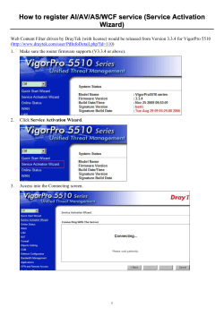


© Copyright 2026