
RI DEM – Blackstone River Bikeway
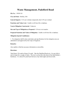
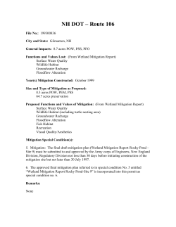
RI DEM – Blackstone River Bikeway
File No.: 199300976
City and State: Pawtucket to North Smithfield, RI
General Impacts: 1.77 acres PEM, PSS, PFO (0.23 permanent, 1.54 temporary)
Functions and Values Lost: (From EA/SOF)
Groundwater Recharge
Floodflow Alteration
Fish Habitat
Wildlife Habitat
Recreation
Year(s) Mitigation Constructed: August 1998
Size and Type of Mitigation as Proposed: 0.3 acre non-tidal emergent
Proposed Functions and Values of Mitigation:
Nutrient Removal
Floodflow Alteration
Wildlife Habitat
Recreation
Production Export
Sediment Retention
Mitigation Special Condition(s):
7. The wetland restoration and mitigation shall be performed as described in the
“Blackstone River Bikeway, Army Corps of Engineers, Section 404 Wetland Mitigation
Issues (Revised 3/24/97)” by Vanasse Hangen Brustlin, Inc., “Blackstone River Bikeway,
Mitigation Plan, Lonsdale Marsh, Cumberland, R.I.” dated “April 2, 1997”.
8. The goals of the mitigation are to replace those functions and values lost from the
filling of approximately 0.23 acre of freshwater wetlands through wetlands restoration. If
during final design, construction, etc., anything found that would affect the achievement
of the mitigation goals, the permittee through their environmental consultant shall notify
the Corps of Engineers, Inspection Section. Measures to help ensure success of the site
shall be taken pending review and approval by the Corps.
Remarks:
None
Directions:
Take 128/95 south toward Dedham/Providence, RI. Stay on I-95 by exiting right in the
Dedham area. Take exit 3, Route 123. Turn onto Broad Street then onto Jones Street.
Street Atlas USA® 2003
©2002 DeLorme. Street Atlas USA® 2003.
Scale 1 : 12,800
TN
www.delorme.com
MN (15.4°W)
0
0
200
400
100
600
200
800
1000
300
1" = 1070 ft
400
500
ft
m
Blackstone River Bikeway
Copyright (C) 1997, Maptech, Inc.
MITIGATION SITE FIELD DATA FORM
Site Name: Blackstone River Bikeway
City/Town: Cumberland
File No. : 199300976
State: RI
Waterbody: Blackstone River
Monitor(s): Keith Wright, Kathleen McKee
Was site constructed?
yes
Is site wetland?
yes
Date: 6-20-02
Plants
Acer rubrum
Carex sp. (ovales)
Cornus amomum
Eupatorium perfoliatum
Fraxinus sp.
Juncus effusus
Lythrum salicaria
Platanus occidentalis
Pontederia cordata
Rumex crispus
Scirpus cyperinus
Solidago sp.
Toxicondendron radicans
Size of proposed wetland: 0.3 acre
Actual size of wetland: same
Landscape position: river plain
Lat/Long Points: 41.96897N W071.33757
Saved GPS Waypoint name: BLA
GPS Tracking Log Name: N/A
Perimeter: TBD
Surrounding land use:
Forest and contiguous PEM wetland
Is wetland function compromised by
surrounding land use?
No
Plant health:
Very good
Invasive Species:
Lythrum salicaria
Wildlife Use:
Green frog, snails, muskrat,
large animal’s sleeping depression;
herbivory such as dogwood trees had chew marks
Page 1 of 2
Soils Data:
DEPTH
0 – 6.5”
6.5 – 14.5
14.5 – 16.5
16.5 – 19
HORIZON
A
fill
A2
B
MATRIX
REDOX
COMMENTS
grayish/white/black debris, shale
silt loam, black/brown
black loam
7.5YR 2.5/1
10YR 2/1
Sketch approximate mitigation site, noting areas and types of wetlands, waters, other features,
landscape position, landmarks, etc., and data and photo point(s):
See field notes
Overall Description of site:
The site is difficult to locate as there is no obvious border between the mitigation site and the rest of the
marsh. A bordering gravel path leads to the site. It was found most easily by the location of a sediment
trap; also note position of radio antenna in distance in relation to this device.
There was sixty square feet of open water surrounded by cattails. The site was predominantly comprised
of Juncus effusus. Diversity increases as distance from open water area increases.
Comments, problems, recommendations:
None.
Page 2 of 2
Blackstone River Bikeway
199300976
0.3 ac
yes
yes
no
forest, PEM, residential
RL PM
50 feet
POW, PEM
W71.33757
N41.96897
5/14/03
100%
no
low
X
0 (?)
X
X
probably recharge
X
X
in Blackstone River floodplain
X
X
dense vegetation
X
dense vegetation, in floodplain
X
in floodplain
X
X
X
frogs, snails, deer, muskrat, signs of herbivory
X
X
X
X
X
none known
199300976
Blackstone River
Cumberland, RI
6/20/02
Approaching up a foot path, site is on the right, looking northwest.
Wettest part of site is on left of photo. It consists of only 10 sq feet or so in the middle.
Wettest part of site (middle)
Looking east from west side
Valley Falls, Rhode Island, United States 29 Mar 1995
Image courtesy of the U.S. Geological Survey
© 2003 Microsoft Corporation. All rights reserved.


© Copyright 2026