
Board of Supervisors Manual A quick reference guide to common VDOT activities
Board of Supervisors Manual A quick reference guide to common VDOT activities © 2013 Commonwealth of Virginia Table of Contents Preface .............................................................................................................................................................. 3 Maintenance .................................................................................................................................................... 4 Adopt a highway .......................................................................................................................................................... 4 Dams ............................................................................................................................................................................ 5 Drainage and drainage easements ................................................................................................................................ 6 Maintenance Budget ..................................................................................................................................................... 7 Mowing ........................................................................................................................................................................ 8 Volunteer Roadside Management Program.................................................................................................................. 8 Offender Labor ............................................................................................................................................................. 9 Private Streets............................................................................................................................................................. 10 Snow Removal ........................................................................................................................................................... 11 Construction .................................................................................................................................................. 12 County Standards ....................................................................................................................................................... 12 Donated Right of Way................................................................................................................................................ 13 Locally Administered Projects ................................................................................................................................... 14 Locally Funded – VDOT administered projects ........................................................................................................ 15 Noise Abatement ........................................................................................................................................................ 16 Paving a Road ............................................................................................................................................................ 18 Options available for paving unpaved roads. ......................................................................................................... 18 Primary, Urban, and Interstate Allocation Process ..................................................................................................... 20 Project Development Timeline .................................................................................................................................... 21 Secondary Construction Budget ................................................................................................................................. 23 Secondary Six-Year Plan ............................................................................................................................................. 24 Planning .......................................................................................................................................................... 26 Comprehensive Plan Consistency with State Plans and Programs ............................................................................. 26 Corridor and Feasibility Studies ................................................................................................................................. 27 Federal Functional Classification ............................................................................................................................... 28 Highway Needs Assessment (HNA) .......................................................................................................................... 30 MPO Transportation Plans and Programs .................................................................................................................. 31 National Highway System .......................................................................................................................................... 32 Regional Long-Range Plans for Transportation (Rural RLRPs) ................................................................................ 33 Small Urban Area Transportation Studies (SUATS) ..................................................................................................... 34 Strategically Targeted Affordable Roadway Solutions (STARS) .............................................................................. 35 Transportation Improvement Programs (TIPs/ Statewide TIP) .................................................................................. 36 Virginia Surface Transportation Plan (VSTP) ........................................................................................................... 37 VTRANS – Virginia’s Statewide Multimodal Transportation Plan ........................................................................... 38 Funding programs ....................................................................................................................................... 39 Airport Access Program ............................................................................................................................................. 39 Appalachian Regional Commission Local Access Road Program ............................................................................. 40 Economic Development Access Program .................................................................................................................. 41 Federal Lands Access Program .................................................................................................................................. 43 Highway Safety Improvement Program ..................................................................................................................... 44 Recreational Access Program..................................................................................................................................... 45 Revenue Sharing Program .......................................................................................................................................... 46 Safe Routes to School ................................................................................................................................................ 47 Transportation Alternatives Program ......................................................................................................................... 48 Board of Supervisors Manual 2013 Operations ..................................................................................................................................................... 49 Roadside Memorials ................................................................................................................................................... 49 Naming Bridges, Highways and Interchanges ........................................................................................................... 50 Park and Ride Lots ..................................................................................................................................................... 51 Red Light Running Cameras (Photo Enforcement) .................................................................................................... 52 Public Landings .......................................................................................................................................................... 53 Trail Blazers and “Public Boat Landings” ................................................................................................................. 53 Residential Cut-Through Traffic ................................................................................................................................ 54 Roadway Lighting ...................................................................................................................................................... 55 Roundabouts ............................................................................................................................................................... 56 Signs ........................................................................................................................................................................... 57 Additional $200 Fine Sign ..................................................................................................................................... 57 Flashing School signs ............................................................................................................................................ 57 Share the road sign ................................................................................................................................................. 58 Street name sign ..................................................................................................................................................... 58 Supplemental Guide Signs ..................................................................................................................................... 59 Watch For Children Sign ....................................................................................................................................... 60 Speed Limits............................................................................................................................................................... 61 Through Truck Restriction ......................................................................................................................................... 62 Traffic Calming .......................................................................................................................................................... 63 Traffic Counts ............................................................................................................................................................ 65 Traffic Signal, Sign or Pavement Marking Requests ................................................................................................. 66 Land development ...................................................................................................................................... 67 Access Management ................................................................................................................................................... 67 Additions to the Secondary System of State Highways ............................................................................................. 68 Guide to Transportation Efficient Land Use Planning and Design ............................................................................ 69 Land Development/Site Plans .................................................................................................................................... 70 Permits (Land Use) .................................................................................................................................................... 71 Secondary/ Subdivision Street Standards ................................................................................................................... 72 Rural Additions .......................................................................................................................................................... 73 Miscellaneous ............................................................................................................................................... 75 Abandonment of Secondary Roads ............................................................................................................................ 75 Bicycle and Pedestrian Accommodation .................................................................................................................... 76 Devolution .................................................................................................................................................................. 77 Discontinuance of a Secondary Road ......................................................................................................................... 78 Golf Carts and Utility Vehicles .................................................................................................................................. 79 Highway Rail Grade Crossings .................................................................................................................................. 81 Virginia Byways......................................................................................................................................................... 82 Towns with Populations Under 3,500 ........................................................................................................................ 83 2 Board of Supervisors Manual 2013 PREFACE This manual was developed as a quick reference guide to the more common activities associated with the Virginia Department of Transportation (VDOT). The purpose of this manual is to provide new members of the County Board of Supervisors, or other public officials, with a better understanding of the Department. The topics cover the activities most commonly performed by the residency and district offices, and may assist in answering questions generated from constituents. In all cases, the information is a broad overview of policy or guidelines. Each residency and district office has unique characteristics that may require that they perform some functions beyond what is stated in this manual. For more detailed information, always contact the local residency or district office of VDOT. Also, VDOT’s Customer Service Center is designed to provide the public with one number (1-800-367-7623) to remember for any transportation related question or request they might have. We hope that this manual is a useful and productive tool in understanding and working with VDOT. This manual is prepared and periodically reviewed and revised by VDOT’s Local Assistance Division in consultation with other VDOT staff. 3 Board of Supervisors Manual 2013 MAINTENANCE Adopt a highway The Virginia Department of Transportation's (VDOT) Adopt-a-Highway Program is one of several initiatives* in the Commonwealth that is focused on cleaning, enhancing, and preserving the state’s environment. There are currently over 1,000 volunteer groups totaling 16,850 participants around the state that have agreed to pick up litter on selected sections of highway four times each year for three years. The sections of highway average two miles each and have saved the taxpayers of Virginia an estimated $3 million dollars each year. The program began in 1988 and is one of the largest programs in the country. From January 1, 2012, to December 31, 2012, volunteers contributed over 34,000 hours of time and collected over 25,500 bags of trash from 2,118 miles of roads. VDOT acknowledges the efforts of families, civic groups, and businesses by erecting an Adopt-aHighway sign imprinted with the name of the organization at the beginning of their adopted highway. For additional information on the Adopt-a-Highway Program, see VDOT’s website: http://www.virginiadot.org/programs/prog-aah-default.asp * Other programs supported by VDOT are Offender Community Service Landscape Program, Volunteer Roadside Management Program, and Offender Labor. 4 Board of Supervisors Manual 2013 Dams The Virginia Department of Transportation does not accept dams as part of the secondary system of state highways, nor does it accept the responsibilities and liabilities associated with any dam as the owner is always responsible for the dam and for performing periodic inspections of dams. An agreement with the county is required as a prerequisite for the Department’s acceptance of a street that crosses a dam or an extrinsic structure. The need for an agreement must be considered on the merits of each case. However, all such agreements are to be submitted to the local designated VDOT contact who will coordinate final negotiation, review, approval, and execution before a related addition assembly is submitted. Ideally, to avoid last minute problems, local VDOT officials notify the staff of the locality during preliminary plat reviews that such an agreement will be required before the related facilities are constructed. Dam agreement forms may be obtained at the local VDOT office and requires two documents with original signatures (one for the locality and one for VDOT’s Central Office). For additional information on Dams and Dam agreements please refer to VDOT’s Guide to Additions, Abandonments, and Discontinuances located at http://www.virginiadot.org/business/resources/additionsabandonmentsanddiscontiniuances.pdf In addition, VDOT will not typically approve the use of highway embankments as dams. When there are extraordinary circumstances based on unique site and roadway conditions, however, requests for approval should be submitted to the VDOT State Hydraulics Engineer. The State Maintenance Division Administrator should also be contacted on all such requests. (VDOT’s Maintenance Best Practices Manual, Section 5.7.6) 5 Board of Supervisors Manual 2013 Drainage and drainage easements Adequate drainage conveyances and facilities are integral components of a safe and structurally sound roadway infrastructure. Inadequate or improperly maintained drainage facilities are responsible for most pavement failures and soil erosion. A road may have its serviceability seriously curtailed, or may even be made impassable as a result of improper drainage maintenance, or inadequate facilities. One of the most important duties of maintenance personnel is the repair and maintenance of the highway drainage system and the importance of this activity cannot be over-emphasized. The highway drainage system includes open channels (paved and unpaved), underdrains, gutters, inlet and outlet structures, catch basins, drop inlets, manholes, storm sewers, and stormwater management facilities. Preventive Maintenance (PM) is any planned cyclical activity performed in advance of a critical need for repair, to reduce or arrest the rate of future deterioration. The activities may correct minor defects as a secondary benefit, but are not initiated based upon an observed deterioration. The goals of a PM program are to extend the useful life of VDOT’s maintainable assets and to preserve their investment. Example of the types of PM activities for drainage items include: Clean soil, debris and vegetation from the underdrain outlet (yearly) Clean cross pipe inlet and outlet to allow proper flow (1-2 years) Application of herbicide to prevent vegetation growth on unpaved shoulders (yearly) VDOT should maintain an easement to protect the roadway and its drainage system, when Department personnel deem it appropriate and necessary. Generally there are two types of easements. The first is recorded in the name of the Department and is usually obtained by Department personnel to resolve individual drainage problems, or as a part of highway improvement projects. The second is dedicated to the County for public use, as a part of subdivisions developed under County ordinances. The Department’s responsibility regarding the two different types of easements is as follows: Drainage Easements Acquired by the Department The Department assumes full maintenance responsibility within the limits of the drainage easement. Drainage Easements Dedicated to a County as Part of a Subdivision Plat The Department will maintain only that portion of the drainage easement, which falls within the right of way limits accepted by the Department when the street is added to the Statemaintained system of highways. The Department will not maintain easements dedicated to a County as part of a subdivision plat. Work within the easement, but outside of the right of way will only be performed when obstructions, etc., create problems within the right of way. 6 Board of Supervisors Manual 2013 Maintenance Budget Beginning in 2002, the Department adopted an asset management approach to planning, budgeting, and execution of maintenance and operations. Under this approach, maintenance and operations budgets are developed and distributed based on the quantity and cost of work needed to preserve, maintain, and operate at a target condition or level of service for roadway assets VDOT is responsible for. Data on asset inventory (counts and total quantities) are collected by contractors and VDOT staff either on an annual or on-going basis. Statistical extrapolation is used to fill gaps where data has not been collected. VDOT performs maintenance work on assets and provides services which it groups into five categories based on functional similarity: Work Category Roadway Traffic and Safety Emergency Response Roadside Facility, Equip, and Other Services Example assets and services Pavement, bridges, shoulders, tunnels Guardrail, signs, markings, signals, lighting ITS assets, snow and ice removal, incident response Vegetation, drainage, barriers Rest areas, ferries, equipment, administration Maintenance activities can be described as: Ordinary Maintenance—work that preserves roadway assets, corrects minor defects or problems, and extends the life of the asset. Planned Preventive Maintenance—any planned activity performed in advance of a need or repair or in advance of accumulated deterioration. PM is planned, cyclical, not conditionbased, and does not add structural capacity to the pavement structure. Repair/Corrective Maintenance—work that is required to return a damaged or deteriorated asset to design functionality and capability. Restore/Replace Activities—the replacement or complete restoration of assets that cannot be repaired. Major Rehabilitation—applies to bridges and pavement only. This work includes full depth reconstruction where the entire pavement asset is removed and replaced. The work may also include restoring structural integrity or correcting major safety defects for bridges and pavements. VDOT uses inventory and condition data, as well as unit cost of maintenance, replacement, and operations activities and performance targets to determine the quantity and cost of activities needed to reach and maintain the network of assets at a targeted level of condition or level of service. The Statewide maintenance and operations allocation is then distributed to the nine construction districts using district level information from the needs assessment. District allocations are distributed at the program level. Districts then distribute funds from their allocation to their residencies, area headquarters, and district offices. Once each organizational unit in the maintenance and operations program receives their budget, they develop more detailed plans for where the money will be spent over the course of the fiscal year. The detailed budgets are then uploaded to the financial management system where they are managed against expenditures. 7 Board of Supervisors Manual 2013 Mowing Mowing practices are shown in Chapter 11 of VDOT’s Maintenance Best Practices Manual. These practices provide the minimum requirements for all mowing operations on roadsides. Practices include those mowing activities that are initiated based on the following primary business needs. 1. Ensuring all related highway safety requirements are met, including but not limited to clear zone, sight distance and guardrail deflection angle requirements, and proper and adequate drainage. 2. Protecting the traveled roadway and to enable the visual inspection of and access to roadside assets and other highway infrastructure including but not limited to ditches, culverts, stormwater basins, pipes and under drains so that other maintenance needs can be identified and planned for. 3. Ensuring efficient management of woody vegetation within the right of way. Any permissible modifications in the application of these practices must be approved by the District Administrator with documented justification. Copies of this approval are to be sent to the State Maintenance Engineer prior to implementing such changes. Volunteer Roadside Management Program This program provides entities such as a local government, private business, community, individual, or civic organization an opportunity to improve the appearance of the right of way by participating in the sponsorship of maintaining existing turf and ornamental plants. Participation in this program can be coordinated through the Residency office and will be formalized with a Land use Permit. Community Service Landscape Program This program, established in accordance with Code of Virginia 33.1-12.2, allows persons convicted of nonviolent misdemeanors who have received a suspended sentence or probation to fulfill their community service requirements by mowing rights-of-way and performing other landscaping maintenance tasks for roads and highways that the Department has the responsibility to maintain. This program is only available in locations where the Local Probation Agency has entered into an agreement with VDOT. 8 Board of Supervisors Manual 2013 Offender Labor VDOT utilizes Offender labor for maintenance activities along roadways in select areas statewide. Supervised Offenders are authorized to perform such work based on a joint Memorandum of Agreement between VDOT and the Virginia Department of Corrections (DOC). VDOT employs DOC’s Offenders on manual, labor-intensive, unskilled activities such as litter pick-up, brush cutting, tree pruning, hand mowing, and culvert cleaning in rural areas. Because of security and safety issues, DOC Offender labor is not allowed in urban areas such as Richmond, Northern Virginia, Williamsburg, Virginia Beach, etc. Inmates must also be in a “trustee” status, that is, not convicted of a serious crime. In Fiscal Year 2011 over $321,000 was paid to DOC for Offender labor use for highway maintenance activities statewide for approximately 214,000 hours of work. VDOT has been partnering with DOC in using Offender labor to reduce VDOT costs and help maintain roads for over 100 years. VDOT’s Maintenance Best Practices Manual contains work areas in which Offenders cannot and can be used. These restrictions are listed below. Prohibited Work Areas for Offender Crews A. Within the political boundaries of any city or town unless specifically exempted per DOC Regulations and in accordance with DOC Operation Procedures Nos. 462 and 463. B. Within any outlying part of a city or town, to include any smaller adjacent community, residential neighborhoods or subdivisions, and shopping centers on the outskirts of a city or town. C. In rural areas, Offender labor shall not be used in the following locations: 1. Interstate highway rest areas, unless closed to the public 2. Within 50 yards of businesses or homes at interchanges 3. Within villages and subdivisions along highways and roads 4. Within 50 yards of businesses at intersections and along highways and roads. 5. Within 200 yards of a school that is in session. 6. VDOT facilities except as specifically authorized by the Department of Corrections. Approved Work Areas for Offender Crews A. Rural portions of Interstate highways, including access ramps, except rest areas open to the public, and within 50 yards of commercial facilities (such as, gas stations, motels, stores) and/or homes at interchanges. B. Along rural portions of primary and secondary highways and roads except in villages, subdivisions or within 50 yards of any built-up area(s) (for example, crossroads or intersections with gas stations, convenience stores, homes). C. Any other state-maintained road that meets the requirements of items A and B above and does not otherwise violate the provision of the section on prohibited work areas and does not jeopardize public safety. D. Within rural areas of the cities of Chesapeake and Suffolk, and other approved towns and cities, subject to the same restrictions as in item B & C above. 9 Board of Supervisors Manual 2013 Private Streets Private streets are those where the use is permissive or privileged by right of ownership/membership. The term is often confused with public streets that are privately maintained. VDOT typically refers to a street not maintained by VDOT as a private street. VDOT’s involvement in the review of private street subdivision plans is limited to their impact on the existing public roadway network in terms of traffic generation, access, and drainage. However, VDOT may review private street subdivision street plans in detail if requested by the local government, which agrees to reimburse VDOT costs on an accounts receivable basis provided the VDOT District agrees to provide those services. Private street connections to state maintained roadways must meet all VDOT criteria for subdivision street connections, such as sight distance, pavement structure, auxiliary lanes, signalization, and permits. Private street connections made to existing VDOT maintained roadways without first obtaining a Land Use Permit for the connection are illegal, may create safety issues and may be removed. Streets are eligible to be accepted into the state's system if they are built to VDOT standards, the required right of way is dedicated to public use, and the street meets all applicable requirements and regulations governing VDOT acceptance. Some older residential streets may be eligible as a rural addition if they are either brought up to standards by others or the street is otherwise eligible for addition and improvement under the rural addition program as mentioned in the section on additions. A VDOT Commissioner’s Directive titled “Road Signs and Speed Limits on Private Roads” provides for the certification of road signs and speed limits on certain private roads as provided for in §§46.2-1307 and 46.2-1307.1 in the Code of Virginia, for law enforcement purposes. 10 Board of Supervisors Manual 2013 Snow Removal The Department will provide snow and ice control services at a level of service consistent with local jurisdictional needs including, but not limited to, emergency access, customer input, commuter and educational systems, economic movement of goods, average daily traffic, industrial access, and other traffic data. Highway needs for snow and ice control overlap highway systems and, as a result, are separated and identified by functional classifications of the highway rather than by roadway systems. Highways and roads are classified into categories of priority routes to ensure the optimal and safe movement of goods and traffic along Virginia's highways during snow and icy conditions. For example, priority 1 highways include all interstate routes, most primary routes, and a few very high-service secondary routes. These routes should be kept free of ice and snow so that traffic can proceed in safety without severe delays, except during periods of heavy falling or drifting snow and ice storms. Generally, this is accomplished within 24 hours after the storm ends. All routes receive progressive and continuous effort to meet the snow removal goals. Routes not designated as priority 1 highways will receive attention as soon as practical and will have appropriate chemical treatment and plowing generally no later than 48 hours after the end of the storm. Dependent upon the forecast, VDOT may apply chemical deicing abrasive to bridges and select routes at the beginning of a storm or possibly prior to the onset of precipitation. On residential streets, sanding is performed as needed and plowing is performed when feasible. Each year the local residency revises snow removal plans for the coming snow season based on local needs and available resources. Contractor supplied hired equipment is used to complement state forces. VDOT does not remove snow from private or commercial roads or entrances. Upon written request VDOT will assist the cleaning of entrances for fire departments, emergency squads, and other emergency providers as operations allow. VDOT provides snow removal service in most incorporated towns of less than 3,500 populations, and on primary roads in some towns with populations over 3,500 depending on which section of the Code of Virginia by which the town is operating. VDOT does not remove snow or ice on sidewalks. VDOT does not remove snow off railroad grade crossings. The railroad has the responsibility to remove snow from the grade crossings. If the railroad company does not remove the snow then the Residency Maintenance Manager will contact the railroad company official regarding removal. Visit the VDOT web site at http://www.virginiadot.org/travel/eoc-main.asp 11 Board of Supervisors Manual 2013 CONSTRUCTION County Standards Counties may develop their own design standards and construction specifications, which meet or exceed VDOT and AASHTO. However, they must be reviewed and approved by VDOT for projects off the National Highway System, and also by FHWA for projects on the National Highway System. Local governments are expected to notify the VDOT Project Coordinator or other local designated VDOT contact whenever alternative designs and specifications are being utilized If a county proposes use of a recognized acceptable concept or material not previously approved for VDOT use, a request shall be submitted to the local designated VDOT manager for review. The local designated VDOT manager, through consultation with appropriate divisions, will determine if the request will be approved for a VDOT maintained street. If it is determined that the nonstandard item may be installed within the dedicated right of way and should be maintained by others, a permit will be required. 12 Board of Supervisors Manual 2013 Donated Right of Way Donated right of way is a means of quickly obtaining right of way for constructing those roads listed on the approved Secondary Six-Year Plan. These roads usually do not have any major environmental, historical, or citizen opposition associated with them. If all property owners on the road agree with the proposed construction, and right of way can be negotiated through donation, the time and cost of preliminary engineering can be reduced. Roads on which donated right of way is obtained can be constructed at a much lower cost. The costs associated with design, title search, appraisal, soils investigation, attorneys' fees and right of way agents are virtually eliminated. However, it is recommended that sufficient title research be performed to ensure that the Commonwealth obtains clear and indefeasible title. The Regional Right of Way and Utilities Manager should be consulted for advice and guidance. When a road is included in the Secondary Six-Year Plan and comes within approximately two years of construction, typically, the residency sends letters to all property owners adjacent to the road advising them that we are beginning our right of way process. VDOT personnel will then contact affected property owners, explain the work necessary to improve the road, and negotiate for donated right of way. Although it is called donated right of way, the property owner does have the right to receive just compensation. Items such as fences, shrubs or trees can be replaced or owners may be paid for the loss. There are several standard deeds that may be used depending on the requirements of the roadway and the property. These deeds are signed by all property owners before a notary public and are recorded in the Circuit Court Clerk's Office of the affected county. By using donated right of way procedures, roads may be constructed more quickly and at a cost significantly less than by using the full design and right of way purchase processes. Board of Supervisors members can assist in the acquisition of donated rights of way by informing the interested parties of this process and encouraging their cooperation with VDOT representatives. The administrating agency is responsible for the appropriate environmental review processes. 13 Board of Supervisors Manual 2013 Locally Administered Projects Various sections of the Code of Virginia provide localities the opportunity to administer transportation projects financed by the Virginia Department of Transportation (VDOT) and to supplement the funding of projects within their jurisdictions. §33.1-12 allows the Commissioner of Highways to enter into agreements with localities, authorities, and other organizations in order to improve and maintain Virginia’s transportation system. §33.1-23.05 allows localities to administer Revenue Sharing projects. §33.1-75.3 allows counties to administer primary highway and secondary highway projects. A project administration agreement is required between the locality and VDOT for any locally administered project. This agreement spells out the terms for a locality to administer a specific project and must be finalized before the locality starts work on the project. For projects utilizing federal funding, federal authorization is required before starting each phase of the project (preliminary engineering, right of way, or construction). Any expenditure made prior to Federal Highway Administration approval of a project phase will not be reimbursed. The Locally Administered Project process is initiated by the locality by completing and submitting a Request to Administer Construction Project Form to the Residency Administrator or other Residency Administrator or other designated local VDOT manager When a locality decides to take advantage of this opportunity it must adhere to applicable Commonwealth Transportation Board (CTB) policies and procedures as well as federal regulations, if using federal funding. Assistance regarding this process can be found on the VDOT web site at http://www.virginiadot.org/business/local-assistance-locally%20administered.asp. A reference guide titled "Locally Administered Projects Manual” is also available on this web site. 14 Board of Supervisors Manual 2013 Locally Funded – VDOT administered projects §33.1-75.3.C of the Code of Virginia allows the Department to agree to administer projects funded by counties Generally, VDOT expects that local governments administer construction projects developed outside VDOT’s six-year plan. However, the Code of Virginia also provides for VDOT administration of projects funded entirely from local revenue sources. This most often occurs when local governments sell bonds for transportation improvement projects, but revenue can be provided with any local revenue source. When a locality wishes to take advantage of this opportunity, it should first coordinate with the Residency Administrator or other Residency Administrator or other designated local VDOT manager who will, in turn, coordinate with the VDOT District staff to ensure adequate VDOT workload capacity exists to meet the locality’s performance expectations. When agreeing to administer a locally funded project, VDOT will require that the project be entered into the appropriate six-year plan and that the project be administered in accordance with VDOT policies and procedures. Project funding is generally required in advance. Once both parties agree that VDOT will administer the project, an agreement outlining administration and funding responsibilities is prepared. 15 Board of Supervisors Manual 2013 Noise Abatement In 1989, VDOT formally established a policy to lessen the impact of highway traffic noise on people in neighborhoods and in other noise-sensitive areas, such as churches, schools, hospitals and certain public recreational areas. The State Noise Abatement Policy was updated in 1997 and was based on Federal Highway Administration (FHWA) regulations. In response to new technology and the industry practices, FHWA proposed changes to federal noise abatement policy and regulation. The final rule was published on July 13, 2010 with an effective date of July 13, 2011. It required each State DOT to revise its noise policy to be in accordance with this final rule. The FHWA reviewed VDOT’s revised noise policy for conformance to the final rule and to assure uniformity and consistency nationwide. The new policy sets out statements on general applicability (FHWA resources, General Assembly mandate, and administration of the policy) as well as creates a companion document to cover details in a comprehensive manner. The companion document is titled “Highway Traffic Noise Impact Analysis Guidance Manual” which was amended August 6, 2013. The VDOT noise policy and guidance manual can be located at: http://www.virginiadot.org/projects/pr-noise-walls-about.asp. A noise wall is a specially designed structure built to reduce noise levels created by nearby highway traffic. It is built only after noise impact studies are conducted and certain conditions are met. VDOT conducts studies and looks into options for reducing noise levels along proposed federally funded highway improvement projects. Projects must meet one of the following conditions to be considered for noise abatement: (1) The construction of a highway on new location; or, (2) The physical alteration of an existing highway where there is either: (i) Substantial Horizontal Alteration. A project that halves the distance between the traffic noise source and the closest receptor between the existing condition to the future build condition; or, (ii) Substantial Vertical Alteration. A project that removes shielding therefore exposing the line-of-sight between the receptor and the traffic noise source. This is done by either altering the vertical alignment of the highway or by altering the topography between the highway traffic noise source and the receptor; or, (3) The addition of a through-traffic lane(s). This includes the addition of a through-traffic lane that functions as a HOV lane, High-Occupancy Toll (HOT) lane, bus lane, or truck climbing lane; or, (4) The addition of an auxiliary lane, except for when the auxiliary lane is a turn lane; or, (5) The addition or relocation of interchange lanes or ramps added to a quadrant to complete an existing partial interchange; or, (6) Restriping existing pavement for the purpose of adding a through-traffic lane or an auxiliary lane; or, (7) The addition of a new or substantial alteration of a weigh station, rest stop, ride-share lot or toll plaza. 16 Board of Supervisors Manual 2013 Noise Abatement, continued Noise Abatement Specialists use computer models to analyze and predict noise levels based on the loudest hour of the day for future conditions. They also measure existing noise levels in various locations along the proposed highway project when there is no existing roadway to use for the computer models. Along with the road's design, they must consider the area's topography, the distance between the road and nearby properties, traffic speeds and the sounds created by different types of vehicles. The computer model uses that data to predict the future noise level, which is compared with Federal Highway Administration (FHWA) and VDOT noise abatement criteria. If this comparison identifies an impact, VDOT noise abatement specialists must investigate noise reduction options. Several options are available. First, VDOT noise abatement specialists recommend to the roadway engineers to shift the road away from the affected properties, or reduce the speed limit or, restrict heavy truck traffic on the road, or design the road so its surface is lower through the affected area, creating a natural sound barrier. Another option is the use of earthen berms to mitigate the noise where space constraints allow the use of a berm. If designing the road differently will not reduce noise, VDOT engineers then consider noise barriers. The noise barriers can reduce traffic noise significantly and improve quality of life for people living behind them. However, noise barriers must meet the following conditions to be feasible and/or reasonable: To be feasible a noise barrier: (1) must reduce noise levels by at least a 5 decibels fifty percent (50%) or more of the impacted receptors experience 5 dB(A) or more of insertion loss to be feasible; and; (2) it must be possible to design and construct the noise abatement measure in the proposed location. The factors related to the design and construction include: safety, barrier height, topography, drainage, utilities, and maintenance of the abatement measure, maintenance access to adjacent properties, and general access to adjacent properties (i.e. arterial widening projects) All of the reasonableness factors listed below must collectively be achieved in order for a noise abatement measure to be deemed reasonable: (1) the viewpoints of the affected citizens shall be obtained through surveys. Fifty percent (50%) or more of the respondents shall be required to favor the noise abatement measure in determining reasonableness, and (2) the noise barrier must be 1,600 square feet or less per benefited receptor to be considered cost-effective, and (3) the noise barrier shall reduce noise levels by 7 decibels for at least one (1) noise impacted property. 17 Board of Supervisors Manual 2013 Paving a Road When the secondary system of highways was established in 1932, VDOT accepted nearly 34,000 miles of unpaved roads. Today, nearly 9,000 miles of state maintained unpaved roads still exist and are an important part of each county’s Secondary Six-Year Plan in addressing the unpaved road needs. The Secondary Six Year Plan information on page 25 describes the allocation process and any unpaved road funds designated are added to the county’s six year plan. Funds designated to improve unpaved roads are allocated to each county based on their proportion of qualifying unpaved roads with traffic volumes over 50 vehicles per day. The Department has not had sufficient funds for distribution to the Unpaved Road Fund since FY09. Department staff that works directly with you will let you know if this changes. The process of revising the Secondary Six-Year Plan includes an advertised public hearing to provide all citizens an opportunity to ask that their road be included in the plan. If all these requirements are met, a road will be improved and paved when funding reserved in the plan becomes available for spending. Options available for paving unpaved roads. The General Assembly has provided additional options in paving unpaved roads in recent years. This has provided increased flexibility and allowed more unpaved roads to be paved than previously possible. The options currently available include the Rural Rustic Road approach, the Pave-In Place approach and the traditional reconstruction approach when greater improvements and additional right of way are necessary. Rural Rustic Road Program In 2003, the “Rural Rustic Road” Program was implemented allowing a flexible approach to paving many unpaved roads. For a road to qualify for rural rustic road treatment, several criteria must be met: 1. The county’s Board of Supervisors must pass a resolution declaring the road to be a “Rural Rustic Road”; 2. The Board of Supervisors indicates that expected growth and traffic increase along the road in the near future is minimal; 3. The curves along the road should be generally adequate for the traffic and any increase in speeds expected after the improvement; 4. Roadway drainage must currently be sufficient or require only minor improvements; 5. The daily traffic volume must not exceed 1500 vehicles. 18 Board of Supervisors Manual 2013 Paving a Road, continued Roads that are good candidates are paved with minimum disruption beyond the ditches and usually result in a significant cost savings. For roads with traffic volumes greater than 400 vehicles per day, 18 foot pavement width is desirable and some typical section improvements may be necessary. The Residency Administrator or other Residency Administrator or other designated local VDOT manager will determine whether this approach is suitable for a requested unpaved road. The Rural Rustic Road approach should be considered first when paving a road but it should be recognized that not all roads are good candidates for this concept. Additional information is available on VDOT’s website at http://www.virginiadot.org/business/local-assistance-programs.asp#Rural Rustic Pave-In-Place Program If the rural rustic road approach is not a good option for a road, the pave-in-place approach might be considered if: 1. The traffic is under 750 vehicles per day; 2. Only minor improvements are needed to accommodate traffic; and 3. Needed improvements can be made within the available, existing right of way. Easements might be necessary for spot improvements. Under the pave-in-place option, the road is improved to a minimum standard of 18 feet of pavement with 2-foot shoulders. Traditional Reconstruction with Additional Right of Way If significant improvements are needed or if significant development is proposed along the road, a more traditional approach is used to reconstruct the unpaved road and improve the alignment. A minimum 40-foot right of way is usually required for these projects with additional right of way or easements acquired based on the proposed improvement. The residents along the road are usually asked to donate any additional right of way needed. If that is done, the funds otherwise required to buy right of way can be used for construction. If additional right of way is needed and will be donated, the donated right of way should be acquired before the project is added to the Secondary Six-Year Plan. 19 Board of Supervisors Manual 2013 Primary, Urban, and Interstate Allocation Process Each year the Commonwealth Transportation Board updates the Six-Year Improvement Program that distributes funds available for construction on the interstate, primary, and urban highway systems, as well as funds available for the secondary system and the other transportation modes; ports, airports, and rail and public transportation. The allocation of state construction funds is distributed per the Code of Virginia, Section 33.1-23.1, generally. The allocation distribution process requires funding to be made available first for the maintenance of highway systems including maintenance payments to localities maintaining their highway system. After maintenance, funds are set aside for administrative, general expenses and other provisions are addressed, including an amount not to exceed $500M in any given year to six categories which includes 5% to pave unpaved roads carrying more than 200 VPD that will cease July 1, 2020; and including up to ten percent of the remaining funds for financing rail projects that mitigate highway congestion. Funds are next allocated to the interstate system exclusive of federal funds and unpaved road funds and then distributed to the primary, secondary and urban systems based on a funding formula as designated in Section 33.1-23.1. Forty percent is allocated to the primary system, and thirty percent each is made available to the secondary and urban systems. Each distribution is exclusive of federal-aid matching funds. The Department has not had sufficient funds for distribution through the systems construction formula for the primary, secondary or urban systems since FY09. However, beginning in FY17 state formula funds will become available for distributrion to the primary, secondary and urban systems. Department staff that works directly with you will let you know if this changes. To seek the maximum input from the Commonwealth’s citizens, planning and programming meetings are typically held during the fall in each of the state's nine construction districts. Advice and input are solicited from members of the General Assembly, County Boards of Supervisors, City and Town Council Members, Planning Districts, Metropolitan Planning Organizations, other public officials, and the general public. Based on input received from the fall meetings, VDOT staff prepares a working draft of the SixYear Improvement Program complying with the policy goals of the Commonwealth Transportation Board that include paying off deficits on completed projects and not creating new deficits, fully funding construction projects by the time they are complete, bringing phased projects or programs to a reasonable stage of completion, and requiring that new projects added to the program be eligible for federal funds. The working draft of the Six-Year Improvement Program is released in the early spring and then final public hearings are held. After the public hearings, the Commonwealth Transportation Board will adopt the final Six-Year Improvement Program for the next fiscal year. The Six-Year Improvement Program also contains projects funded under the current Federal Transportation legislation as well as the specially funded projects designated by the U. S. Route 58 Corridor Development Program, Highway and Rail Safety Improvement Programs and others. 20 Board of Supervisors Manual 2013 Project Development Timeline The following outlines major phases of the road building process. Many of the tasks included within each phase occur concurrently. Each project’s unique circumstances, requirements, risks, and complexities tailor the project development process to the individual project. VDOT projects are reflected in Virginia's Six-Year Improvement Program, which is updated annually. Public comment is solicited and welcome at many points throughout the process. It is best to become involved as early as possible in the transportation decision-making process. 1. The Planning Phase may last from 1-24 months. a) Often acting upon requests for road improvements from local governments, VDOT planners work with federal and other state agencies, local governments, regional planning organizations, and residents to develop short- and long-range plans for improving the highway system. How long the planning and programming process takes depends on factors relating to the significance of a recommended transportation improvement. Factors include the functional role of a roadway proposal (with respect to regional travel, mobility and/or access), costs and availability of revenues, environmental and/or economic impact, and the support of the affected agencies, regional planning organizations, jurisdictions and the public. Participating regional planning organizations include urbanized area Metropolitan Planning Organizations and Planning District Commissions, as well as Virginia’s non-urbanized area Planning District Commissions. b) Virginia’s statewide long range transportation plan (VTrans) contains Virginia’s strategic highway and transit goals, and top corridors of statewide significance. c) VDOT and DRPT develop a long range Virginia Surface Transportation Plan (VSTP) that identifies recommendations based on state transportation need-based assessments and the plans of metropolitan areas’ Constrained Long Range Plans and non-metropolitan areas’ Rural Regional Long Range Plans. The recommendations are prioritized and provided to the Commonwealth Transportation Board (CTB) citizen panel appointed by the Governor for consideration during the annual updates to Virginia's six year improvement program. The CTB also considers projects based on technical information and the input received from government agencies, regional planning organizations, local governments and the public. 2. The Scoping Phase may last between 1-8 months depending on project complexity and includes: confirming the project purpose and need, initiating the environmental review process (ERP) which identifies if the State Environmental Review Process is required, determining the level of environmental document (if required) and the need for water quality permits, identifying stakeholders, establishing the project team, holding the initial scoping team meeting, performing the survey, developing the initial design, considering context sensitive solutions, and evaluating public involvement strategies. The initial step is to refine project goals and objectives, determine the location and/or the typical section of a roadway. This is based on anticipated traffic volume, the roadway's functional classification (arterial, collector, local), and terrain (level, mountainous, rolling). 3. Preliminary Design Phase may range from 1-18 months and includes: design of roadway, structures and bridges, traffic control devices/intelligent transportation systems, and landscaping; determining right of way and utility impacts, performing constructability and work zone reviews, 21 Board of Supervisors Manual 2013 Project Development Timeline, continued completing the environmental document for NEPA, holding the public hearing team meeting and public hearing, and obtaining design approval. a) A preliminary design is prepared and reviewed by all stakeholders in the project, such as affected property owners and local governments. b) Sometimes offering two or more possible proposals, VDOT conducts information meetings and/or public hearings to involve citizens before making a final decision on the location of the roadway and details such as right-of-way width, type of intersections and interchanges, and materials needed. Information meetings and public hearings are advertised in the newspaper and other media, and citizens have 10 days to offer comments or documents about the proposed location and/or design after the information meeting or public hearing. c) The CTB must approve the location and major design features before final design and right of way acquisition can begin. 4. The Detailed Design Phase may last between 1-12 months and includes: design of roadway, structures and bridges, traffic control devices/intelligent transportation systems, and landscaping; determining right of way and utility impacts, developing erosion and sedimentation/hydraulic plans, performing utility design, holding the utility field inspection, authorizing right of way (total takes), performing constructability and work zone reviews, and holding the field inspection team meeting. 5. The Final Design and Right of Way Acquisition Phase may range from 1-24 months and includes: finalizing the design of roadways, structures and bridges, traffic control devices/intelligent transportation systems, and landscaping; finalizing right of way and utility impacts, erosion and sedimentation plans, and utility design; obtaining environmental permits, holding the utility field inspection, authorizing right of way and utilities (partial takes), performing constructability, work zone, maintenance of traffic/transportation management plan reviews, and holding the pre-advertisement conference team meeting. 6. The Advertisement Phase may last from 1-5 months and includes: finalizing plans, specifications, and estimates, completing the bidability review, securing environmental and right of way certifications, verifying funding, and obtaining environmental permits. 7. The Construction Phase may range from 1 to over 36 months. a) Based upon an engineering estimate of what will be required to build a road, VDOT invites contractors to bid on a project, and the Commonwealth awards a contract to the lowest qualified bidder, stipulating cost and length of time for completion. b) Overseeing every step of the work, VDOT inspects for quality, conformity to project requirements, and environmental protection. c) VDOT inspectors manage traffic flow through the project, keeping affected property owners informed and ensuring that work zone safety guidelines are met. d) Once a project is completed, a road is opened only after a satisfactory inspection. Completion delays can occur due to inclement weather, late delivery of materials, and unforeseen discoveries such as underground utilities or unstable soil. 22 Board of Supervisors Manual 2013 Secondary Construction Budget VDOT's construction is a pay-as-you-go program. Authorization to initiate different phases of a project is based on a spending plan that demonstrates funding will be available to cover expenses for that phase. 100% of the construction costs must be fully funded within 12 months of construction completion. When the Secondary Six-Year Plan is produced, the Department is dealing with approximations and projections in funding. The Board of Supervisors typically approves the Secondary Six-Year Plan and Construction Priority List in the first quarter of each calendar year based on those funding projections. The Department uses the approved priority list to apply the funds in the Secondary Construction Budget for the upcoming fiscal year. Occasionally, project costs exceed the funds programmed in previous budgets for that project. This creates deficits that must be addressed. Generally the first priority in the Secondary Six-Year Plan and Secondary Construction Budget is to finance deficits. Allocations are then made available for county wide or incidental improvements such as traffic and safety services and rural additions. Allocations may be made for the unpaved roads, major reconstruction and bridge replacement projects based on priorities. Normally construction projects in the first year of the Secondary Six-Year Plan are financed in the Secondary Construction Budget. After holding a public hearing on the proposed projects and considering citizen comments, the Board of Supervisors, with the concurrence of the Residency Administrator or other Residency Administrator or other designated local VDOT manager, must adopt an official construction budget priority list for the first fiscal year, usually along with the resolution approving the updated Secondary Six-Year Plan. If the construction budget was not approved along with the Secondary Six Year Plan it must be adopted in a separate public hearing and along with a resolution approving budget priority list prior to June 30th each year. However it is recommended to have it approved in the March/April time frame. The secondary construction budget is included in VDOT’s Annual Fiscal Year Budget which is usually approved by the Commonwealth Transportation Board in late June each year. Until the secondary construction budget is approved by the Board of Supervisor’s and the Department’s budget is approved by the CTB, the allocations are not posted as indicated in the approved Secondary Six-Year Program and/or the final Secondary Construction Budget. The allocations included in the budget are part of the approved Secondary Six-Year Plan and the Department’s Six-Year Improvement Program. The allocations are not posted in the Department’s Financial System until the Board of Supervisors has approved the secondary construction budget. This may delay the authorization for a project to begin PE, RW or CN activities. 23 Board of Supervisors Manual 2013 Secondary Six-Year Plan Although the Department of Transportation has authority for the construction and maintenance of the secondary road system, Virginia laws create a partnership between the Department and the County Board of Supervisors in improving local transportation. The Board of Supervisors has the responsibility for establishing priorities for the Secondary Six-Year Plan. Typically in the fall of each year, workshops are held with the Board of Supervisors to develop a list of project priorities for the updated Secondary Six Year Plan. Once a draft is established, the county and VDOT will schedule the annual Secondary Six-Year Plan public hearing usually in the first quarter of the calendar year. These hearings gather information from the public to consider projects in the county to be added in the Secondary Six-Year Plan. Highway funding for the Secondary Six Year Plan is derived from state and federal gasoline taxes, vehicle title fees, vehicle sales tax and one-half percent of state's sales tax and distributed to the primary, urban and secondary systems after addressing maintenance, administrative costs and other priorities established in the Code of Virginia. Funds are allocated to the interstate system exclusive of federal funds and then distributed to the primary, secondary and urban systems based on a funding formula as codified in Section 33.1-23.1. Forty percent of the amount available for systems construction is allocated to the primary system, and thirty percent each is made available to the secondary and urban systems. Each distribution is exclusive of federal-aid matching funds. (PD suggested eliminating altogether-I moved and added same language for SYIP) Distribution of the available secondary construction funds is based on Section 33.1-23.4, of the Code of Virginia which establishes a 20% area and 80% population factor. The area of each county is derived by Geographic Information Systems Mapping and population figures are obtained from the Weldon Cooper Center. The distribution formula results in less-populated areas receiving less funding than urbanized areas. Distribution of Unpaved Roads Funds for unpaved roads carrying more than 50 VPD is based on the ratio of unpaved secondary roads in the county serving fifty or more vehicles per day to the total number of such roads in the Commonwealth as indicated in Section 33.1-23.1:1, of the Code of Virginia. The Unpaved Roads Fund was created by the General Assembly to address the need for paving secondary unpaved roads. The Department has not had sufficient funds for distribution through the systems construction formula for the primary, secondary or urban systems or the unpaved road fund for roads with traffic volumes over fifty vpd since FY09. However, beginning in FY17 state formula funds will become available for distribution to the primary, secondary and urban systems and the unpaved road fund. Department staff that works directly with you will let you know if this changes. Moved and some additions Distribution of CTB Formula Unpaved Roads Funds carrying more than 200VPD is based on the ratio of unpaved secondary roads in the county serving fifty 200 or more vehicles per day to the total number of such roads in the Commonwealth as indicated in Section § 33.1-23.1 B, of the Code of Virginia. These funds will cease on July 1, 2020 per this section of the Code of Virginia. 24 Board of Supervisors Manual 2013 Secondary Six Year Plan, continued Distribution of available revenue for Telecommunications Fees (Public Right of Ways Use Fee) based on Section 56-468.1, of the Code of Virginia, and the revenues from the sale of Residue Parcels on the secondary system in the county are included in the annual Secondary Six-Year Plan revenue projections each year The predictability of funding amounts is greatly dictated by the financial climate of the times and changes of funding levels by the federal government. Therefore, in dealing with construction funds, especially in the Secondary Six-Year Plan, the Department is dealing with approximations or projections. The Secondary Six-Year Plan is based on estimated funding which is provided by the Financial Planning Division. Updating the Secondary Six-Year Plans on an annual basis allows the department to provide an update on schedules and estimates of current projects in the plan. The process gives citizens a chance to request new improvements annually; facilitates Metropolitan Planning Organization (MPO) planning process required by MAP-21; allows the Board of Supervisors to evaluate their program annually and update it to address any changes in county priorities; and it allows the Residency Administrator or other Residency Administrator or other designated local VDOT manager to review projects included in the plan to obligate federal funds as part of VDOT’s annual Federal Fiscal Year Strategy. It should be noted however that changes in priority can impact the ability to fully utilize federal funds. Close coordination with VDOT is essential when considering shifts in priority to ensure federal funds can still be obligated and utilized efficiently. 25 Board of Supervisors Manual 2013 PLANNING Comprehensive Plan Consistency with State Plans and Programs Consistency between local, regional, and state plans is desirable for the orderly development of infrastructure. When plans and programs are not consistent, resources are expended for questionable benefit. Chapter 729 of the 2012 Acts of Assembly included elements intended to promote consistency between the transportation plan portion of the local comprehensive plan and the Commonwealth Transportations Board’s (CTB) VTrans (statewide transportation planning document), Six-Year Improvement Program, and the location of state routes chosen by the CTB. The Code of Virginia at §15.2-2223 requires a locality’s transportation plan to be consistent with these state documents. Information on Chapter 729 can be found on VDOT’s website at http://www.virginiadot.org/info/local-state_plan_and_program_consistency.asp. The law requires a locality to send draft changes to its transportation plan to VDOT, which shall review the submitted changes and provide comments to the locality within 90 days. Once a locality’s plan (or change to the plan) is adopted, it must provide a copy to VDOT. VDOT staff reviewing local transportation plans will consider a plan consistent if it includes the projects set out in the above listed documents and does not include recommendations that would prevent those projects from advancing. Not all projects contained in the Six-Year Improvement Program need be incorporated into local transportation plans in order for those plans to be consistent; only those projects that are “significant new, improved, or relocated” highway projects need be included, which means projects on Major Collector (or higher classification) roadways that are: i) On new location; ii) Relocate a roadway; or iii) Add one or more through lanes or an interchange. If VDOT determines that a comprehensive plan’s transportation plan is inconsistent with VTrans, the Six-Year Improvement Program, or route locations as noted above, VDOT must notify the Commonwealth Transportation Board of such inconsistency and the Board may take action to try and encourage consistency between the state plans and the local transportation plan. Comprehensive plan reviews are routinely conducted by the District Office planning staff serving that particular locality. 26 Board of Supervisors Manual 2013 Corridor and Feasibility Studies VDOT’s Transportation and Mobility Planning Division, in coordination with each district’s planning staff, conducts both corridor and feasibility studies throughout the state. Corridor studies seek to identify the mix of transportation improvements that would be most effective in moving people and goods in specific travel corridors and balancing those improvements with available funding and neighborhood and community concerns. Feasibility studies on a proposed strategy are conducted to determine the degree to which: (a) the design or location is economically justified, (b) an alternative is considered preferable from an environmental or social perspective, or (c) eventual construction and operation can be financed and managed. For more information on corridor and feasibility studies, visit: http://www.virginiadot.org/projects/pr-studiescorridor.asp . 27 Board of Supervisors Manual 2013 Federal Functional Classification Functional usage of a roadway is based upon its mobility and accessibility. Choice of a travel route can be logically related to the roadway's ability to access land and the mobility through an area. The Federal Highway Administration (FHWA) has set up functional classification guidelines. The Federal Functional Classification Guidelines contain a list of classifications and descriptions given for each class of roadway. Roads may be classified as local, collector or arterial roads. Urban or rural U.S. Census designations also have importance because design features are based on these designations. In example, in the rural areas the design speeds may be much higher than the design for urban streets. In urban areas, the streets and roads may require a curb and gutter design while the rural roads will normally feature shoulders and ditches in the design. Briefly, for each of three areas (rural, urbanized and smaller urban areas): Local roads function to provide a higher degree of access but lower travel mobility-flow, Collectors provide a mixture of access and mobility, for through movement and access, & Arterials, with two sub-classes “minor” and “principal”, provide lower access and higher mobility with the functional standards for minor and principal arterials being relatively high for through traffic. Functional classification is based on road-service features, and impacts several factors including: A project road improvement’s design horizon year date (This affects the time span over which the facility must be minimally adequate: generally 11 years after advertisement for lesser functional classifications, or 22 years after advertisement for higher functional classifications Applicable geometric design standards of the VDOT Road Design Manual (which adopts the AASHTO 2004 Green Book’s design LOS guidance on pages 84-85), as well as local and/or Subdivision Street Acceptance Requirements, collector or arterial standards. Also, rural, urban or urbanized area classification is a related consideration especially from possible changes from annexations, and/or population census updates with respect to urban or urbanized areas) The allocations of transportation funds to Districts of the state, such as for state primary roads (with respect to arterials). Development and/or maintenance of local roads are ineligible for federal funding and responsibilities for this class of roads are private, local and/or state government concerns. Access management features (spacing-frequency and/or type of access such as interchanges, intersections, and roadside entrance, exit and/or driveway points) Eligibility for traffic calming measures VDOT is in the process of finalizing a comprehensive statewide review of Virginia’s federal functional classification system. It is anticipated that FHWA approval of the revisions will be received in early 2014. Once FHWA approval is received, revised federal functional classification maps will be available on the VDOT website. The current functional classification maps may be viewed at http://www.virginiadot.org/projects/fxn_class/home.asp. Federal Functional Classification, continued 28 Board of Supervisors Manual 2013 A County or City can request the classification or reclassification of a particular road segment under the system by working with their local VDOT office. Except in the VDOT Northern Virginia District, the request of a metropolitan locality should be accompanied with a supporting Metropolitan Planning Organization resolution. Additional information on Federal Functional Classification can be found at: http://www.fhwa.dot.gov/planning/processes/statewide/related/highway_functional_classifications /. 29 Board of Supervisors Manual 2013 Highway Needs Assessment (HNA) The Highway Needs Assessment (HNA) is meant to address the highway portion of the requirement for an inventory of all transportation construction capacity needs, as indicated in the Code of Virginia §33.1-23.03: The Commonwealth Transportation Board shall, with the assistance of the Office of Intermodal Planning and Investment, conduct a comprehensive review of statewide transportation needs in a Statewide Transportation Plan setting forth assessment of capacity needs for all corridors of statewide significance, regional networks, and improvements to promote urban development areas established pursuant to § 15.2-2223.1. The assessment shall consider all modes of transportation. Such corridors shall be planned to include multimodal transportation improvements, and the plan shall consider corridor location in planning for any major transportation infrastructure, including environmental impacts and the comprehensive land use plan of the locality in which the corridor is planned. In the designation of such corridors, the Commonwealth Transportation Board shall not be constrained by local, district, regional, or modal plans…. The HNA is one component of the overall statewide multimodal plan, VTrans. The HNA is comprised of objective, system-generated improvements (based largely on TRB’s Highway Capacity Methodology) for all functionally classified highway systems across Virginia, with human input limited to highway inventory (pavement width, number of lanes, etc.) and the review of traffic forecasts. The capacity threshold for the HNA was defined as: LOS C- Rural Areas, LOS DUrban Areas, and LOS D- Urbanized Areas. The system generates improvements to highways (including TSMs, pavement widening, and additional lanes) to meet the capacity thresholds, and develops cost estimates for these improvements. The Transportation and Mobility Planning Division is responsible for development of the HNA, which is a component of the Virginia Surface Transportation Plan (VSTP) and the Statewide Multimodal Transportation Plan, VTrans. All of these plans are on a four year update cycle. The next VTrans update will occur in 2012. 30 Board of Supervisors Manual 2013 MPO Transportation Plans and Programs Virginia’s Metropolitan Planning Organizations (MPOs) (work to address the transportation issues of each of Virginia’s urbanized areas (areas of 50,000 population or more) through their longrange plan, short range program, transit planning, rideshare programs, park & ride efforts and corridor studies. The membership of an MPO board typically consists of representatives of the metropolitan area’s locally elected government along with representatives of the area’s public transportation operators and state transportation officials. A VDOT official is usually the designated state transportation representative on an MPO board. Each MPO in Virginia utilizes various analytical techniques to identify current and future congestion problems and to test the effectiveness of proposed alternatives. The MPOs are required to develop and maintain a fiscally Constrained Long-Range Transportation Plan (CLRP) for transportation in the MPO area. Each CLRP is updated every 5 years in air quality attainment areas and every 4 years in air quality nonattainment areas. These plans cover at least a 20 year planning horizon and include project recommendations for: Regionally significant capital improvements such as major widening, new location facilities, bridges and bridge replacements, etc. Operational Improvement for congestion management and safety – turn lanes, closing cross-overs, signal coordination, access management Transit and Travel Demand Management (TDM) – bus routes, transit improvements, parkand-ride lots, ride sharing MPOs are also required to develop short range programming documents, known as Transportation Improvement Programs (TIPs). TIPs are staged, multi year, inter-modal program that include of all FHWA and FTA funded transportation projects to be implemented in the next four years. Each TIP is required to be financially constrained and consistent with the MPO’s CLRP. A State law was passed in 2011 under Chapter 554 (S 1112, affecting § 33.1-23.03:01 and creating § 33.1-223.2:25) that reflects the regional transportation planning duties and responsibilities of MPOs, and specifies that the state is to provide meaningful opportunity to MPOs for obtaining their inputs, communicate proposed state priorities and consider the regional priorities identified by the MPOs. State laws passed in 2012 under Chapter 729 (HB 1248, affecting §15.2-2223, 33.1-12(f), etc.) direct that the metropolitan regional CLRP and Transportation Improvement Program of a MPO is to be consistent with Virginia’s Six-Year Improvement Program, the statewide transportation plan (known as VTrans), and the route locations decided by the Commonwealth Transportation Board. 31 Board of Supervisors Manual 2013 National Highway System Virginia’s National Highway System (NHS) is comprised of highways of national significance, based on the federal functional classification. This system of highways includes the Interstate System, its STRAHNET Routes and major collectors, and Virginia’s Congressional high priority routes. “Other” routes identified for inclusion in the NHS are those that provided access to major ports, airports, public transportation facilities, and other major intermodal transportation facilities. The NHS also includes important existing and proposed rural and urban Principal Arterials. In June of 2012 Virginia had a total of 3,441 NHS miles. Virginia’s total NHS mileage was capped by federal targets. However, in July of 2012, a new federal transportation law, Moving Ahead for Progress in the 21st Century, removed the cap and significantly expanded the NHS network to include certain principal arterials. VDOT has requested and received conditional approval on additional routes to the National Highway System network. As of November 2012, the Virginia expanded NHS network is estimated to be 4,358 miles. NHS designation of a highway facility allows the use of more sources of federal funding and requires additional design considerations. FHWA final approval will be forthcoming pending coordination with local jurisdictions and regional planning organizations For additional information on the National Highway System, including a map of NHS routes in Virginia, please see: http://www.fhwa.dot.gov/planning/nhs. 32 Board of Supervisors Manual 2013 Regional Long-Range Plans for Transportation (Rural RLRPs) This initiative is aimed at creating regional transportation plans in rural areas that compliment those in the metropolitan areas of the state. VDOT works with each region to evaluate the transportation system in the rural areas and to recommend a range of transportation improvements that could best satisfy existing and future transportation needs through partnerships with Virginia’s Planning District Commissions and local governments. The regional plan identifies needs based upon the Goals and Objectives established by the region. The Virginia Department of Transportation uses these regional plans as a foundation for identifying Interstate and Primary system priorities for the Six-Year Improvement Program. The plans are also useful to counties and their respective Residency Administrator or other Residency Administrator or other designated local VDOT manager when developing the Secondary Six-Year Program. While this plan covers functionally classified secondary roadways, it is important to note that each county has authority over the recommendations on the secondary system within their jurisdiction. The list of recommendations from the regional long range plans is used in the statewide transportation planning process to better quantify the statewide magnitude of needs. The analysis and plan recommendations are limited to those transportation facilities within the PDC’s boundaries that are outside of established metropolitan study areas. The transportation system that was evaluated is limited to federal functionally classified routes of minor collector and above. Each RLRP has been developed as a vision plan and will be reviewed every five years. It is VDOT’s goal that each region will be able to use these plans to identify regional priorities for transportation funding. The RLRP process will be used to vet recommendations on the interstate and primary highway systems from both the VSTP and STARS initiatives. RLRP information is accessible on the web at http://www.virginiadot.org/projects/rural_regional_long-range_plans.asp. 33 Board of Supervisors Manual 2013 Small Urban Area Transportation Studies (SUATS) VDOT has initiated a project to review the transportation plans for small urban areas across the Commonwealth. The project includes updates to 43 "small urban areas" (those towns and cities with populations less than 50,000 people). The existing plans address transportation issues and identify travel needs in each community for the next 20 years. Although the primary focus of each plan is the "thoroughfare highway system"—those arterial and collector roads and highways that connect urban areas, the plans also address local needs and other modes of transportation. The information in the SUATS are a resource for addressing capacity and safety issues on the transportation system not only to VDOT, but to localities, organizations, and the public as well. This resource is an important component of local comprehensive and transportation plans. These studies illuminate the linkage between future land use and transportation needs, and address road safety, traffic congestion, multi-modal needs, and mode linkage problems. Recommendations on the primary road system from SUATS are included in the VSTP. Reviews of small urban area transportation needs are being examined and considered through the newer rural RLRP process that creates regional transportation plans for rural areas. Decisions have been made by VDOT district planners, PDCs and localities in certain areas of the state to eliminate the SUATS in their area and incorporate it into the RLRP process to have one planning document. For more information regarding SUATS –visit the VDOT website at http://www.virginiadot.org/projects/sm_urbanplans/SUA_index.asp 34 Board of Supervisors Manual 2013 Strategically Targeted Affordable Roadway Solutions (STARS) The objective of the VDOT STARS II (Strategically Targeted Affordable Roadway Solutions) Program is to develop comprehensive, innovative transportation solutions to relieve congested bottlenecks and solve critical traffic and safety challenges throughout the Commonwealth. The STARS II Program, which is led by the VDOT Transportation and Mobility Planning Division in partnership with the Traffic Engineering Division, brings together planners, traffic engineers, safety engineers, roadway design engineers, and maintenance specialists to jointly identify cost-effective measures aimed at improving safety and reducing congestion. These transportation solutions can typically be designed and implemented within three years depending on their impact on adjacent properties. Candidate STARS II projects are often identified at intersections, on corridors, and at bottleneck and safety hot spots primarily located in urban and suburban areas. Potential projects also focus on solving multimodal challenges for pedestrians, bicycles, passenger cars, and transit vehicles, where applicable. STARS II Process Selected STARS II Program recommended improvements are then advanced to the preliminary design phase to identify a more detailed and accurate project cost estimate and schedule. During this design process, potential design exceptions, environmental or right-of-way issues, and subsurface utility conflicts are identified. This program phase allows for identification of potential project challenges and formation of creative and constructible solutions in the early stages of project development. STARS Improvements Short-term - Short-term improvements can be implemented by state or local forces typically in less than one year. Examples - - cutting back foliage to improve visibility, adding supplemental guide signs or warning signs, pavement markings Intermediate Term - Intermediate improvements are typically constructed by VDOT contractors with benefit/cost analyses generally performed to secure funding. Examples - additional travel lanes, intersection modifications, extension of an acceleration lane at an interchange Long Term - Improvements in the long-term category are generally more extensive and, as such, are not ideal candidates for implementation under this program. Examples - major interchange modifications roadway realignments - projects with significant right-of- way impacts For more information on the STARS program, contact the State Transportation Planner at 804.786.2985, or your local VDOT District Planner. 35 Board of Supervisors Manual 2013 Transportation Improvement Programs (TIPs/ Statewide TIP) A Transportation Improvement Program (TIP) is a short range programming document that identifies all the FHWA and FTA funded transportation regionally significant highway and public transit projects that are proposed to be advanced in a metropolitan region in the next four years. Each metropolitan area has a Metropolitan Planning Organization (MPO) that adopts a financially constrained TIP as well as a financially constrained long-range transportation plan for its metropolitan area. The Statewide Transportation Improvement Program (STIP) is a complete list of all FHWA/FTA funded projects to be advanced within the state for the next four years. The projects in the STIP include those to be implemented in the metropolitan areas as well as in the non-metropolitan areas. The STIP outlines planned obligations of federal revenues and is financially constrained. Projects contained in the STIP should be consistent with the statewide transportation plan and planning processes, and MPO plans, TIPS and processes. The state must submit a new STIP to FHWA and FTA at least every four years for approval. Amendments or administrative modifications (adjustments) to the STIP can be processed and submitted at any time for approval. The TIPs and STIP shall include all regionally significant projects requiring federal approval or permits even if no FHWA or FTA funds are used in their construction. A regionally significant project is generally defined as a project which serves regional transportation needs or may affect the air quality conformity finding for the region. Projects must be financially constrained and have been through a public involvement process. Federal planning laws (23 USC 134 and 135) and regulations (23 CFR 450 and 420) govern TIP and STIP development. 36 Board of Supervisors Manual 2013 Virginia Surface Transportation Plan (VSTP) Developed jointly by the Virginia Department of Transportation (VDOT) and the Virginia Department of Rail and Public Transportation (DRPT), the Virginia Surface Transportation Plan (VSTP) serves as a blueprint for effective and sustainable statewide transportation investments, policies and planning initiatives. Under the guidance of the Secretary of Transportation and consistent with the Governor’s Strategic Multimodal Plan and goals fo the Virginia statewide multimodal transportation policy plan, the VSTP provides performance based recommendations for public transit, rail, highway and transportation demand management. Transportation needs identified in the plan are used to help determine highway projects for the Six-Year Improvement Program. The VSTP is a vision plan, and is not financially constrained. Transportation and Mobility Planning Division is responsible as the lead VDOT office for the development of the VSTP. The Plan is updated at least once every four years. The 2035 VSTP Update was released in April, 2013. Information on the VSTP Plan is available at: http://www.vtrans.org/virginia_surface_transportation_plan.asp 37 Board of Supervisors Manual 2013 VTRANS – Virginia’s Statewide Multimodal Transportation Plan VTrans is the Commonwealth of Virginia’s statewide multimodal transportation plan, which identifies goals, strategies and policies to address multimodal transportation needs over a 20-year planning horizon in accordance with requirements set forth in 23 U.S.C. 135 and VA Code 33.123.03. VTrans serves as the “umbrella” planning document for the state, establishing the direction from the Transportation Secretariat for all transportation planning initiatives. The legislative requirements for the statewide multimodal plan include: carrying out a continuing, comprehensive, and coordinated statewide transportation planning process, including the development of a statewide transportation plan that facilitates the efficient, economic movement of people and goods in all areas of the state. VTrans goals include: economic vitality; safety and security; connectivity, accessibility and mobility for people and freight; environmental stewardship; maintenance and preservation; transportation and land use; and program delivery. VTrans also identifies multimodal investment corridors (Corridors of Statewide Significance) that are critical throughways across and within the state, and identifies recommendations for improvements to those corridors based on the seven planning strategies to ensure future mobility. The development of VTrans is the responsibility of the Office of Intermodal Planning and Investment, and must be updated at least once every four years. Additional information about VTrans can be found at www.vtrans.org . 38 Board of Supervisors Manual 2013 FUNDING PROGRAMS Airport Access Program The airport access road program is used to provide access roads to licensed public use airports. The Commonwealth Transportation Board administers the program in cooperation with the Department of Aviation. Funding for airport access projects, as provided under the authority of Section 33.1-221 of the Code of Virginia, is allocated from the Economic Development, Airport and Rail Access Fund. Prior to the allocation, the governing body of the county, city, or town must, by resolution, request the access funds. Airport access funding may not be used for the acquisition of rights of way or adjustments of utilities, and the governing body must state in its resolution that these items will be provided at no cost to the program. A maximum allocation of $650,000 ($500,000, unmatched and up to $150,000 matched dollar for dollar) may be awarded within a fiscal year to provide access for any one airport. The locality requesting the access funding will be responsible for the appropriate environmental studies and permits, if applicable. Additional information is available on VDOT’s website at http://www.virginiadot.org/business/localassistance-access-programs.asp 39 Board of Supervisors Manual 2013 Appalachian Regional Commission Local Access Road Program The Appalachian Regional Commission (ARC) Access Road Program aims to better link the Region’s businesses, communities, and residents to the Appalachian Development Highway System (ADHS) and to other key parts of the Region’s transportation network. This program offers a flexible approach designed to meet the local needs and provide a financing mechanism to support a variety of economic development opportunities throughout the Region. The Region includes 410 counties in 13 states. It extends more than 200,000 miles from southern New York to northeast Mississippi and is home to nearly 23 million people. Virginia has twenty-three counties and seven independent cities that are eligible for participation in the ARC program. The following is a list of Virginia’s localities: the counties of Alleghany, Bath, Bland, Botetourt, Carroll, Craig, Buchanan, Dickenson, Floyd, Giles, Grayson, Highland, Lee, Montgomery, Pulaski, Rockbridge, Russell, Scott, Smyth, Tazewell, Washington, Wise and Wythe, and including the cities of Bristol, Buena Vista, Clifton Forge, Covington, Galax, Lexington, Norton and Radford. Funding for this program is provided from a qualifying State’s ADHS allocation. The ARC Code gives State Governors the option of using up to $500,000 plus 5% of their annual ADHS apportionment, not to exceed more than $1,000,000 each year for local access road projects. These funds are part of ADHS funds apportioned to the State for use on the ADHS. Eligible criteria for local access road projects are roads which serve industrial and commercial developments, residential developments, recreational areas, and educational areas. The project eligibility will be determined by the ARC Board. ARC local access road funds can be used for preliminary engineering, right of way and/or construction of new roads. Local access road funding is not allowed for resurfacing/rehabilitation, upgrading and/or safety improvements on roads previously built with ARC local access road funds. Approved Projects need to be included in the STIP and must follow FHWA and State requirements. For additional information on the Appalachian Regional Commission, counties are encouraged to visit www.arc.gov. 40 Board of Supervisors Manual 2013 Economic Development Access Program The Economic Development Access Program is administered by the Commonwealth Transportation Board, which allocates funds, as provided under the authority of Section 33.1-221 of the Code of Virginia, for eligible projects from the Economic Development, Airport and Rail Access Fund. The purpose of the program is to finance the construction or improvement of roads, with the exception of primaries, to new or expanding qualifying economic development sites. These roads will provide access from the nearest adequate publicly maintained road to the primary entrance of the qualifying site. Qualifying establishments are determined by the Commonwealth Transportation Board in consultation with the Virginia Economic Development Partnership and the Virginia Department of Business Assistance. An initial request must be made to the local governing body by a qualifying establishment desiring financial assistance. A letter of request to the appropriate local governing body must include the following: A. B. C. D. E. F. G. H. I. Intent to build or expand on a designated site Description and location of the site Target date for building construction Target date for beginning operation Private capital investment planned on the site, itemized Products to be manufactured The number of new jobs to be created Access road improvements requested Estimates of the numbers of additional employee vehicles and truck traffic which will use the access road on an average business day The locality should ensure that the qualifying establishment submits a copy of this letter to the Residency Administrator or other Residency Administrator or other designated local VDOT manager, along with a preliminary road plan showing the entire parcel of land and the locations of: the building, major site features, the proposed entrance, the proposed access road, and existing public roads in the vicinity of the site. It is also advisable to forward a copy of this letter to the Virginia Economic Development Partnership and the Virginia Department of Business Assistance. If the local governing body supports the request, it should prepare and approve a resolution formally requesting the allocation of Economic Development Access Program funds. If a new road is to be constructed, the resolution should state that right of way and utility adjustments will be provided at no cost to VDOT, and that the road will be added to the secondary system or to the local road system as appropriate. Economic Development Access Program, continued 41 Board of Supervisors Manual 2013 If the project involves improvement of an existing road, the resolution should state that right of way and utility adjustments will be provided at no cost to the Economic Development, Airport and Rail Access Fund. Economic Development Access projects may be either regular (where an existing qualifying establishment is expanding, or a new qualifying establishment is under firm contract) or bonded (where no qualifying establishment is under contract to build). The maximum allocation for any project is limited to the lesser of: the reasonable cost of an adequate road or 20 percent of the qualifying private investment made by the private qualifying establishment to be served exclusively by the access road project. The maximum unmatched allocation within any one fiscal year is $500,000. Where the cost is estimated to exceed $500,000, the governing body may request up to $150,000 in supplemental funds, which must be matched on a dollar-for-dollar basis from the locality. Any ineligible project costs and all costs exceeding the maximum allocation must be borne by the locality. The Residency Administrator or other Residency Administrator or other designated local VDOT manager will assist the locality in preparing sketches and cost estimates for the requested road improvements. Certain developments meeting the criteria of Major Employment and Investment (MEI) sites as designated by the Virginia Economic Development Partnership may be considered for separate allocations for a design-only project and for successive allocations to accomplish the construction project. Qualifying private investment includes the cost of land, the cost of site preparation and building construction, and the cost of newly purchased equipment essential to the operation of the establishment. Eligible capital investment requires documentation by copies of deeds, executed construction contracts, checks, and purchase orders, and this documentation is subject to verification by VDOT. Capital costs incurred more than six months prior to the date of the resolution of the governing body will normally be disallowed. If a locality desires road access for a possible site development, it is necessary that the governing body guarantee that a bond or other acceptable surety will be provided to cover the cost of the road that is not justified by qualifying development. The time period for a bonded project is five years from the date of the CTB resolution approving the project and allocation. As of July 2006, the CTB policy also allows consideration of investment established within twenty-four months following the termination of the original five-year period for a partial reimbursement of any returned funds. The locality requesting the access funding will be responsible for the appropriate environmental studies and permits, if applicable. Additional information is available in the Economic Development Access Program Guide and on the VDOT website at http://www.virginiadot.org/business/local-assistance-access-programs.asp 42 Board of Supervisors Manual 2013 Federal Lands Access Program Under MAP-21, the core Federal Lands Highway Programs were restructured. With this new transportation bill the Forest Highway Program (FHP) and Public Lands Highways Discretionary Program (PLHD) came to an end. The new Federal Lands Access Program (Access Program), which will be administered by Eastern Federal Lands (EFL), builds upon the structure of the former programs. The goal of the Access Program is to improve transportation facilities that provide access to, are adjacent to, or are located within Federal lands. Similar to the FHP, the statute requires a Tri-party committee to make programming decisions and develop a multi-year program of projects. This committee will be known as the Programming Decision Committee (PDC). The PDC is comprised of a representative of the Federal Highway Administration (FHWA), a representative of the Virginia Department of Transportation, and a representative of a county or other local governments within that State. Projects will be selected through an application process. The PDC will consider the selection criteria and Federal Land Management Agency input to optimize the use of the statewide Federal Lands Access Program funds. The funds available to Virginia from this program vary from year to year and are subject to being reduced each year by applicable rescissions, set-asides, or any other limitations cited in law. Unlike the FHP and PLHD, a local match of 20% is now required for the Federal Lands Access Program. The funds made available under this program will be available for the current year plus three additional years. 43 Board of Supervisors Manual 2013 Highway Safety Improvement Program Federal transportation legislation, Moving Ahead for Progress in the 21st Century Act (MAP-21), was signed into law July 2012; and, increases funding for the Highway Safety Improvement Program (HSIP). The HSIP is structured to make significant progress in reducing highway fatalities and severe injuries. The HSIP requires a Strategic Highway Safety Plan (SHSP) to identify the targeted safety emphasis areas and key strategies and actions to reduce severe crashes. Virginia’s SHSP through 2016 provides strategies using the 4E approach of engineering, education, enforcement and emergency response. The HSIP funding implements the engineering (infrastructure) improvements to address highway crashes related to roadway departures, intersections and speeding, and bicycle and pedestrian safety under § 23 USC Section 148. Setaside funds for Highway-Rail Grade Crossing Safety Program are defined under § 23 USC Section 130. VDOT has developed a Highway Safety Improvement Program (HSIP) for the Commonwealth of Virginia that involves the identification of high crash locations, an analysis of crash trends, a safety assessment of existing conditions and feasible countermeasures, and the prioritization and scheduling of improvement projects. This program includes the Highway Safety Program (HSP), the Bicycle and Pedestrian Safety (BPS) Program and the Highway-Rail Grade Crossing (H-RGC) Program The VDOT Traffic Engineering Division (TED) serves as the focal point for administration of the safety programs (HSIP) within the Commonwealth of Virginia. VDOT Districts identify safety problems and prioritize improvements to mitigate crashes. Local governments should submit and coordinate safety improvement proposals for locations they recommend for improvement to local District liaisons. The proposals are evaluated on a statewide basis or district basis to ensure that locations in need of improvement have a better opportunity to be selected and funded. The candidate projects are selected based on an economic analysis (Benefit/Cost ratio), number and type of target crashes, project cost and schedule or based on documented risk assessments for non-motorized and highway-rail grade crossing improvements. The intent of the HSIP is to expend federal funds on safety improvements that can be designed and constructed within three years. Projects should not require acquisition of significant rights of way, nor should they require extensive environmental review and mitigation. Federal funds must be authorized within two months of the STIP approval. Selected projects failing to get funds authorized within two months must request a time extension from TED. Projects are subject to removal if the extension is not granted by TED. Details on HSIP application guidelines, deadlines and project selection can be found on the VDOT TED website at http://www.virginiadot.org/business/trafficeng-default.asp 44 Board of Supervisors Manual 2013 Recreational Access Program The purpose of the Recreational Access Program is to provide adequate access to recreational areas or historic sites operated by the Commonwealth of Virginia, a local government, or authority. Both roads and bikeways are eligible for program funding. The program is administered by the Commonwealth Transportation Board, and funding is provided under the authority of Section 33.1-223 of the Code of Virginia, with the appropriate designation and recommendation by the Director of the Department of Conservation and Recreation for access to recreational areas or by the Director of the Department of Historic Resources for access to historical sites. Roads constructed under this program become a part of the appropriate highway system. Separate bikeways constructed outside the right of way of the road become the responsibility of the authority or agency maintaining the site, which they serve. Prior to the allocation, the governing body of the county, city, or town must, by resolution, request the access funds. Recreational Access Program funding may not be used for the acquisition of rights of way or adjustments of utilities, and the governing body must state in its resolution that these items will be provided at no cost to the program. The road or bikeway should be located to provide the most direct, cost-effective, access to the site. The access project should end either at the entrance to the area or at an internal parking lot serving the park facility or historical area. Recreational access roads and bikeways are expected to be open to the public at all times; however, they may be closed during specific hours for security purposes. No fee may be charged for the use of these roads or bikeways. A maximum of $400,000 may be allocated for an access road to a facility operated by a state agency. For a bikeway to a facility operated by a state agency, the maximum allocation is $75,000. These funds are intended for eligible costs associated with design and construction of access roads and bikeways. For an access road to a facility operated by a locality or authority, the maximum unmatched allocation is $250,000. Up to an additional $100,000 may be allocated if matched dollar-for-dollar from other than highway sources. A maximum of $60,000 unmatched may be allocated for a bikeway to a facility operated by a locality or authority. Up to an additional $15,000 may be requested if matched on a dollar-for-dollar basis by the locality or authority. There is no annual limit on the number of recreational access projects per jurisdiction. The funding maximums apply only to individual projects. Also, if the appropriate criteria are met, both an access road and a bikeway may be funded separately to serve the same facility. The agency, locality or authority operating the facility will be responsible for the appropriate environmental studies and permits, if applicable. Additional information is available in the current guide for the Recreational Access Program and on the VDOT website at http://www.virginiadot.org/business/local-assistance-access-programs.asp 45 Board of Supervisors Manual 2013 Revenue Sharing Program The purpose of the Revenue Sharing Program is to provide additional funding for use by a county, city, or town to construct, reconstruct, improve or maintain the highway systems within such county, city, or town, and for eligible additions in certain counties of the Commonwealth. Locality funds are matched with state funds with statutory limitations on the amount of state funds authorized per locality. The program is administered by VDOT in cooperation with participating localities under the authority of Section 33.1-23.05 of the Code of Virginia. An annual allocation of funds for this program is designated by the Commonwealth Transportation Board. Application for program funding must be made by resolution of the governing body of the jurisdiction requesting the funds. The application package must include the resolution and the detailed application for funds form. If a locality is requesting funds for a project outside its jurisdiction, concurrence from the affected jurisdiction must be provided. Towns not maintaining their own streets are not eligible to receive revenue sharing funds directly; their requests must be included in the application of the county in which they are located. Project funding is allocated by resolution of the Commonwealth Transportation Board. Construction may be accomplished by VDOT or by the locality under agreement with VDOT. The Revenue Sharing Program is typically used to provide funding for immediately needed highway systems projects or to supplement existing projects. Projects receiving Revenue Sharing funds are to be initiated utilizing at least a portion of the funds within one year of the allocation. Funds may be de-allocated if the project is not initiated within three years. Below is a list of work that could be considered eligible for Revenue Sharing financing: Deficits on completed VDOT administered construction or improvement projects Supplemental funding for projects listed in the adopted Six-Year Plan and ongoing construction or improvement projects. Construction or improvements included in either the adopted Six-Year Plan or the locality’s capital plan Improvements necessary for the acceptance of specific subdivision streets otherwise eligible for acceptance into the system for maintenance New hard surfacing New Roadway included in a locally adopted plan Maintenance on highway systems consistent with the Department’s operating policies Details on application deadlines and project selection can be found on the VDOT website at http://www.virginiadot.org/business/local-assistance-access-programs.asp#Revenue_Sharing 46 Board of Supervisors Manual 2013 Safe Routes to School The Federal-aid Safe Routes to School (SRTS) Program was created by the Safe, Accountable, Flexible, Efficient Transportation Equity Act: A Legacy for Users Act (SAFETEA-LU Section 1404) in 2005. Under SAFETEA-LU, SRTS funds were made available for infrastructure and noninfrastructure projects that promote walking and biking as a safe and convenient travel option for elementary and middle school children in grades K-8. The recent federal-aid highway and transit reauthorization act, known as Moving Ahead for Progress in the 21st Century (MAP-21), has changed the funding structure for SRTS activities, shifting future funding from the SRTS program to a competitive grant process for the new Transportation Alternatives Program. Applying for funding for SRTS activities is a competitive process. VDOT administers two types of funds: Non-infrastructure funds are for education, encouragement, enforcement (law) and evaluation activities which further the stated purposes of SRTS Infrastructure project funds are for improvements that provide bicycle and pedestrian accommodations or safety enhancements. During FY2013 and 2014, the SRTS program will transition from SAFETEA-LU to MAP-21, until the remainder of the SAFETEA-LU funds are sub-allocated. SRTS infrastructure funds allocated through SAFETEA-LU have been entirely sub-allocated. Localities interested in funding SRTS infrastructure activities should refer to the Transportation Alternatives Program. By fiscal year 2015, it is planned that all SAFETEA-LU non-infrastructure funds will be suballocated, and all SRTS projects will be implemented using the Transportation Alternatives Program selection process. The purposes of the SRTS program are: 1. to enable and encourage children, including those with disabilities, to walk and bicycle to school; 2. to make bicycling and walking to school a safer and more appealing transportation alternative, thereby encouraging a healthy and active lifestyle from an early age; and 3. to facilitate the planning, development, and implementation of projects and activities that will improve safety and reduce traffic, fuel consumption, and air pollution in the vicinity of schools. All non-infrastructure projects require a formal endorsement by a school or school division. The Virginia SRTS Program requires that applicants create an Activities and Programs Plan for the affected School(s). The plan is a written document stating the school community's intentions for making walking and bicycling to school(s) sustainable and safe. The plan must be submitted to VDOT and approved in advance of the submittal of applications for funding. Information about non-infrastructure applications and other SRTS materials can be found on the VDOT SRTS website at: www.virginiadot.org/saferoutes 47 Board of Supervisors Manual 2013 Transportation Alternatives Program On June 29, 2012 Congress passed “Moving Ahead for Progress in the 21st Century” (MAP-21) which became effective October 1, 2012. In the new legislation the former Transportation Enhancement (TE) Program as set forth in SAFETEA-LU, was replaced with the Transportation Alternatives Program (TAP). The newly created TAP combines several programs including many of the former Transportation Enhancement (TE) activities – now referred to as “Transportation Alternatives Eligibilities” – the Recreational Trails program and the Safe Routes to School program. As set forth in MAP-21, funds for the Recreational Trails Program (administered by the Department of Conservation and Recreation) will be taken off the top before any additional sub-allocations occur. The remaining TAP funds will be split, with 50 percent of these remaining funds being distributed based on population and 50 percent being distributed anywhere statewide. In addition, MAP-21 established that Metropolitan Planning Organizations (MPOs) in the four identified Transportation Management Areas (TMAs) which are urbanized areas with a population over 200,000 will make project selections with the population based allocations in their TMA. The Commonwealth Transportation Board (CTB) will make project selections with the remaining allocations. Several activities previously eligible under the Transportation Enhancement program are no longer eligible and some eligible activities have been modified. Below are the ten (10) transportation alternatives eligibilities as outlined in MAP-21: 1. Construction, planning and design of on-road and off-road trail facilities for pedestrians, bicyclists, and other non-motorized forms of transportation. 2. Construction, planning and design of infrastructure related projects and systems that provide safe routes for non-drivers. 3. Conversion and use of abandoned railroad corridors for trails for pedestrians, bicyclists or other non-motorized transportation users. 4. Construction of turnouts, overlooks and viewing areas. 5. Inventory, control or removal of outdoor advertising. 6. Historic preservation and rehabilitation of historic transportation facilities. 7. Vegetation management practices in transportation rights-of-way. 8. Archeological activities relating to impacts from the implementation of a transportation project eligible under Title 23. 9. Environmental mitigation activities including abatement and prevention activities to address water pollution related to highway runoff. 10. Environmental mitigation activities to reduce vehicle-caused wildlife mortality or to restore and maintain habitat connectivity. Additional information about the Transportation Alternatives Program, the application process and eligible projects is available at http://www.virginiadot.org/business/prenhancegrants.asp. 48 Board of Supervisors Manual 2013 OPERATIONS Roadside Memorials VDOT’s Roadside Memorial Program serves to maintain a safe highway system. At the site of fatal crashes or other fatal incidents, grieving families or friends often wish for a roadside memorial to be placed within the highway right of way. The Department is sensitive to families and friends who have lost loved ones in crashes, or other incidents on the highways of the Commonwealth of Virginia. The establishment of the Roadside Memorial Program will serve to provide the families a formal remembrance of a loved one who lost his or her life on the highway. The Program fosters a healing process and a way for people to begin to feel closure on a very tragic event and provides a visual reminder to others to drive safely. Both major goals — safe highway systems and roadside remembrance — should be met in order for the Roadside Memorial Program to be successful. Eligibility Any human fatality that occurs on the state highway system is eligible for a Memorial Marker. Family members of the victim may file a land use permit request for a Memorial Marker. If any member of the immediate family objects to the marker, the permit will be denied. If an adjacent property owner objects, the marker must be moved. Procedures No state funds shall be utilized for the design, production, installation or maintenance of roadside memorials, plaques, and other devices placed within the right of way that commemorate the memory of persons killed in vehicle crashes within the right of way of any state highway. VDOT will only provide support in a very limited way by coordinating the specific location of the marker to ensure highway safety. The program will be paid for entirely by the person(s) requesting the marker. Requests for a memorial marker within the state highway right of way shall be submitted to the local VDOT Residency Maintenance Manager by completing a VDOT land use permit. The permit fee and the bond are to be waived. The permit is to be issued through VDOT’s Land Use Permit System, so that the installation date can be tracked. VDOT personnel will assist the permittee(s) to identify a safe location where the sign is to be erected and provide guidance as to other procedural requirements. 49 Board of Supervisors Manual 2013 Naming Bridges, Highways and Interchanges Bridges highways and interchanges in Virginia can be named by the Commonwealth Transportation Board (CTB) or by action of the General Assembly. The naming of a facility by the CTB occurs at the request of a local jurisdiction, which must agree to bear the costs of providing and erecting appropriate signs. Maintenance of signs, once erected, will be performed by VDOT through its normal sign maintenance budget. Under Section 33.1-12 (4) of the Code of Virginia, the CTB can name a bridge, highway or interchange to honor a deceased person. The General Assembly may name a bridge or highway or interchange for any purpose or person (deceased or alive) through a bill that is enacted into law. The CTB may not name a bridge, highway or interchange that has previously been named by the General Assembly. The procedure to request the CTB to name a bridge highway or interchange is: 1. A request, in the form of a formal resolution from the local government, must be provided to the Residency Administrator or other Residency Administrator or other designated local VDOT manager. The resolution must indicate that the local jurisdiction will pay all costs for the sign, though funding may come in part or in full from the family or a support group. The most current version of Traffic Engineering Division Memorandum 278 carrying the General Subject, "Highway Signs“, and the Specific Subject "Named Bridges, Highways, and Highway Segments” and the most current version of the “Manual on Uniform Traffic Control Devices” shall be used by local governments as a guide in selecting the text for the proposed sign. Sign size, exact location, color, font and other display details will be at VDOT discretion. 2. VDOT’s Maintenance Division will review the request and prepare all necessary documents for action by the CTB. 3. If approved by the CTB, VDOT will install the signs and bill the locality for all associated costs. 50 Board of Supervisors Manual 2013 Park and Ride Lots Park and Ride lots are parking lots used by commuters who prefer to drive only part of the way to their destination and either carpool, vanpool or use transit or another mode (i.e. bicycling or walking) for the remainder of their trip. Commuters often choose to take advantage of Park and Ride lots in order to reduce congestion on the roads, reduce adverse impacts to air quality and save money on gas and vehicle maintenance. Typically, the lots are signed to indicate their purpose, but in some instances Park and Ride lots are “unofficial” and local commuters simply know they are able to park there for the day. VDOT keeps an inventory of approximately 300 Park and Ride lots, statewide. Of those lots, VDOT owns and maintains approximately 100. Other entities such as jurisdictions, private owners, local transit companies, etc. own and maintain approximately 120 lots. Additionally, there are “unofficial” lots; meaning commuters use them regularly, but the area has never been officially established as a Park and Ride lot location. The Park and Ride lot inventory was last physically updated in 2011. The audit resilts were used to update the Park and Ride inventory and VDOT now updates this statewide inventory (including official as well as unofficial lots) annually in order to ensure the information provided is as detailed and comprehensive as possible. This includes adding any new lot locations that are not currently listed in the inventory, as well as adding additional information obtained regarding existing lots that are currently listed. VDOT’s external website contains a section dedicated to Park and Ride lots. Within that section, there is an interactive map where commuters can locate Virginia Park and Ride lots that can be utilized in their commute. A link to the interactive map is available at: http://www.virginiadot.org/travel/parkride/home.asp Commuters can click on a Park and Ride lot location shown on the map and be presented with information regarding the lot such as: name, address or intersection, route number, number of spaces (including handicap), if bus service is available, if the lot is lighted and/or paved, and what other amenities may be available (bike racks/lockers/bus shelter, etc) In addition to the interactive map, the VDOT external website provides detailed information and additional links for Park and Ride lot locations in some of the more congested areas of Virginia; Northern Virginia (Arlington, Fairfax, Loudoun, and Prince William Counties) and Hampton Roads. Information and additional links are provided regarding parking and services available from some local metro and bus facilities, car/van pool opportunities, HOV lane updates, resources available in Maryland, Smart Tag, Slug Lines, etc. The website also contains information for rideshare agencies or localities in need of Park and Ride resources. 51 Board of Supervisors Manual 2013 Red Light Running Cameras (Photo Enforcement) The 2007 General Assembly added § 15.2-968.1 to the Code of Virginia allowing the use of cameras in Virginia counties, cities, and towns to enforce compliance with traffic signals. The legislation allows localities by ordinance to install and operate red light running camera systems at no more than one intersection for every 10,000 residents within the locality. In Planning District 8 (area served by the Northern Virginia Regional Commission), localities may install and operate red light running cameras at no more than 10 intersections or one intersection for every 10,000 residents, whichever is greater. During the 2012 Legislative Session, additional changes were made to § 15.2-968.1 which removed VDOT from the process for approving red light running camera systems at intersections effective July 1, 2012. This legislation also removed VDOT from the process where signals are owned, operated and maintained by VDOT. In order to fulfill our responsibility regarding our signals, VDOT will use authority granted under the Land Use Permit process to manage those requests for installations of RLC systems on VDOT’s right of way, regardless of who owns maintains and operates the signals. All other requirements of the original legislation, Chapter 903 Section 15.2-968.1, remain in effect and are summarized below. The legislation requires both an engineering safety analysis and annual system monitoring. When selecting potential intersections for installation of red light running cameras, the legislation states localities shall consider the following factors: The accident rate for the intersection. The rate of red light violations occurring at the intersection. The difficulty experienced by law-enforcement officers to apprehend violators. The ability of law-enforcement officers to apprehend violators safely within a reasonable distance from the violation. The engineering study should document the current signal’s clearance intervals (yellow and allred), whether the signal is coordinated with other signals along the corridor, and the current condition of other safety features (i.e., lane markings, median control, speed limits, signing, etc.). The engineering safety analysis is required to be stamped and signed by a licensed professional engineer. The legislation also contains additional requirements for a minimum 0.5 second grace period between the time the signal turns red and the time the first violation is recorded by the camera; a public awareness campaign prior to implementation or expansion of a red light running camera program; placement of conspicuous signs within 500 feet of the intersection approach at which a red light running camera is installed; monthly system evaluations and annual program certifications. Information detailing the engineering safety analysis, the request process for localities to install RLR cameras on VDOT maintained facilities and other information on red light running cameras can be found on VDOT’s website at www.virginiadot.org/info/photored.asp. 52 Board of Supervisors Manual 2013 Public Landings Upon request by the Virginia Department of Game and Inland Fisheries (DGIF), VDOT will assume the responsibility for the maintenance of launching ramps located at public landings, which are under permit and have been constructed by others. The maintenance of boat ramps will be in accordance with the general practices and specifications established by VDOT. VDOT will also maintain the road leading to the ramp. VDOT will be responsible for the maintenance of launching ramps, based on the following conditions: A. The sponsor shall submit to the VDOT District Administrator (DA) a plan for the ramp in accordance with the minimum requirements as shown on standard plan LR-1 (found in VDOT’s Road and Bridge Standards) and the Joint Memorandum of Understanding. Evidence of the concurrence of the Board of Supervisors shall accompany the submission. The DA shall review the proposed plan and make such suggested changes as he/she finds appropriate. The DA is authorized to approve the plan. B. The ramp shall be constructed in accordance with the approved plans and supplemental specifications for launching ramps. C. Upon the request of the Board of Supervisor, VDOT will take over the completed ramp for maintenance. Boat launching ramps should be maintained in as near their original constructed condition or subsequently improved condition as possible. Launching ramps shall be inspected after each flood, storm or excessive high tide. Inspections should include a check for erosion or scour under or around the slab, and for deposits of sand or other debris on the ramp, which might affect its service. Any erosion or debris should be corrected as soon as practical. Trail Blazers and “Public Boat Landings” An agreement has been secured between VDOT and the DGIF for the erection of trailblazers within VDOT right of way bearing the message “PUBLIC BOAT LANDING”. The procedure for the erection of these signs is as follows: A. The DGIF Boating Access Program Manager will contact the Residency Maintenance Manager, who will contact the District Traffic Engineer and arrange for a joint inspection of the intersections where trailblazers are required. The exact location of each trailblazer is to be staked on the ground. B. The trailblazer will begin at the nearest intersection primary route and follow the most direct routing to the boat landing. C. DGIF will furnish the trailblazers posts, hardware, labor, and equipment necessary to complete the sign installation at the approved locations. The signs will be erected in accordance with Department specifications for sign placement as shown in the Manual on Uniform Traffic Control Devices. D. DGIF is responsible for all maintenance of the signs. Should a sign need maintenance or replacement, contact the Facilities Director, DGIF, P.O. Box 11104, Richmond, Virginia 23230. 53 Board of Supervisors Manual 2013 Residential Cut-Through Traffic The Code of Virginia, in section 46.2-809.1, allows for the development of a residential cutthrough traffic policy and procedure for the control of residential cut-through traffic on designated secondary highways. “Residential cut-through traffic" refers to vehicular traffic passing through a residential area without stopping or without at least an origin or destination within the area. The provisions of this section do not apply in cities, any town that maintains its own system of streets, or any county that owns, operates, and maintains its own system of highways. The Commonwealth Transportation Board adopted the Policy and Procedures for the program “Control of Residential Cut-Through Traffic” on May 9, 1996. The policy is accompanied by an “Operating Guide” that provides information on alternatives, analysis and procedures. The policy allows a county or town to request that VDOT review and address possible solutions to identified cut-through traffic problems in residential areas. In order for a street to be eligible for consideration under the program it must be a local residential street with a minimum of 150 cut-through trips occurring in one hour in one direction and with 40% or more of the total one hour, single direction volume being cut-through traffic. The county or town initiates these procedures by resolution of the local governing body requesting that VDOT review and address possible solutions to the identified problem of residential cutthrough traffic. This request is submitted by the county/town to the Residency Administrator or other Residency Administrator or other designated local VDOT manager along with supporting data as prescribed in the policy which includes information on the subject roadway(s) and associated peripheral streets, documentation that the street meets the eligibility requirements and verification that a petition outlining the perceived problem and signed by at least 75 percent of the total occupied households within the primary use area is valid. The request by the county or town prompts VDOT to complete a study of the roadway network identified in the formal request. The county or town and VDOT then work jointly to obtain comments from local agencies and the public and reach an agreement on the final remedial measures. VDOT will determine the appropriate alternatives and convey the findings and recommendations of VDOT to the county/town. If the local governing body and VDOT fail to agree on the remedial measures to be implemented, the governing body may appeal to the Commissioner of Highways. The Commissioner of Highways will analyze all the supporting data and render a decision, which will be binding. Remedial measures utilized on local residential streets that meet the support data requirements set forth above may be fully funded with state secondary road funds (based on the availability of funds) with concurrence of the local boards of supervisors. 54 Board of Supervisors Manual 2013 Roadway Lighting Roadway lighting on Virginia roadways is provided by VDOT when it is determined that it will assist the traveling public in its safe passage. VDOT policy covers the conditions when VDOT may pay for the construction and maintenance of roadway lighting, or when costs should be borne by others. In part, this policy states: VDOT may construct, maintain, and operate roadway lighting on highway systems which are maintained by it, where such lighting is deemed necessary for traffic safety by VDOT engineers. The cost of the installation of the lighting shall be funded from annual construction allocations to the system. The cost of maintenance and operation of lighting will be borne by the appropriate system maintenance funds. Where roadway lighting on highway systems is requested by other entities for their benefit and convenience, and is not deemed necessary for traffic safety by the engineers of VDOT, the installation, maintenance, and operation of the lighting shall be provided by and at the sole expense of those other entities, provided all necessary permits and agreements have been secured. Where approved lighting plans exist, VDOT may provide conduit and other roadway lighting amenities, at project cost, to avoid future disruptions to traffic. Roadway, pedestrian, and decorative lighting included on a road by a land development project, where that road will become a part of the State System of Highways, will not necessarily become a part of the VDOT road inventory. Permits for the continued operation of that lighting by others may be necessary. Any request for a roadway lighting system or a modification to an existing system should be made in a formal written request submitted to the Residency Administrator or other Residency Administrator or other designated local VDOT manager. In order to qualify for VDOT installation of conduits and other amenities necessary to avoid traffic interruption during the installation of roadway, pedestrian, decorative or security lighting by others, post VDOT construction, a full plan of such lighting must be submitted for approval and the follow-on construction of the lighting must be planned within a reasonable amount of time, such that the conduits, etc. will remain in a serviceable condition. 55 Board of Supervisors Manual 2013 Roundabouts Roundabouts, have proven to be a safe and efficient geometric design to reduce delays and improve traffic operations, the Virginia Department of Transportation, in consideration of House Joint Resolution 594 from the 2003 Virginia Legislature, has implemented the procedure for comparing a roundabout with a traditional signal / stop condition on construction projects. This procedure also includes reviewing and approving roundabout designs which best serve safety and operational needs at existing intersections planned for upgrades and proposed locations planned for development by Localities. Roundabout designs are based on NCHRP Report 672, Roundabouts: An Informational Guide, http://onlinepubs.trb.org/onlinepubs/nchrp/nchrp_rpt_672.pdf. During the preliminary plan development stages, the aaSIDRA (Akcelik & Associates Signalized & Unsignalized Intersection Design and Research Aid) program is applied, comparing all turning movements and applicable volumes for present day and design year volumes. If the comparison results indicate a roundabout would serve a specific intersection better than a traffic signal, a roundabout should be the Designer’s first priority of intersection control. The approval process for roundabouts is as follows: Secondary System- The VDOT Districts may approve up to a traffic design volume of 10,000 VPD. Roundabout designs in which the counts are beyond this volume should be submitted to the VDOT Central Office Roundabout Review Committee for review. The committee will make recommendations to the State Location and Design Engineer for approval or disapproval. Appeals of the State Location and Design Engineer’s decision will go to the Chief Engineer for resolution. (When a VDOT District receives a request for a roundabout from an outside entity, and the design volume is under 10,000 VPD but desires Roundabout Committee review and input. The submittal may be sent to the State Location and Design Engineer. It will be reviewed and comments and/or recommendations will be returned in a timely manner.) Primary or Urban Systems- The VDOT Districts will submit roundabout designs to the VDOT Central Office Roundabout Committee for review. The approval and appeals will be the same as used above for these roadway systems with one exception, urban systems will require approval of the Local Assistance Division Administrator as well as the State Location and Design Engineer. The process listed above applies to: Roundabouts proposed through new construction projects Roundabouts proposed during road safety improvements and/or upgrades Roundabouts proposed by Counties, Localities, Consultants and Developers For more information, click on http://www.extranet.vdot.state.va.us/locdes/Electronic%20Pubs/2005%20RDM/AppendF.pdf and www.VirginiaDOT.org/Roundabouts 56 Board of Supervisors Manual 2013 Signs Additional $200 Fine Sign The Additional $200 Fine Sign Program, last amended by the General Assembly in 2006 in § 46.2878.2 of the Code of Virginia, allows a locality to request that VDOT install signs advising motorists of a maximum fine of $200, in addition to other penalties provided by laws, for exceeding the speed limit. The sign must be installed on a local residential street, a collector street, or a minor arterial street with residential characteristics. The posted speed limit must be 35 mph or less. The VDOT District Administrator has approval authority for these signs. It is the responsibility of the county or town to initiate these procedures by requesting, through a resolution of the local governing body, that VDOT install the appropriate signs as stipulated in §46.2-878 of the Code of Virginia. This request will be submitted to the Residency Administrator or other Residency Administrator or other designated local VDOT manager along with the following support data. 1. Identification of the neighborhood and specific highway(s) where the signs are to be installed. 2. Confirmation that the highway(s) meet the definitions of local residential, collector or minor arterial streets. 3. Notification that a speeding problem exists and that the increased penalty has community support. The Residency Administrator or other Residency Administrator or other designated local VDOT manager, upon receipt of the adopted resolution and supporting data, will review the assembly and submit it to the VDOT District Administrator. After VDOT staff reviews the field locations and upon approval of the District Administrator the requested signs will be installed. Sign installation will take place within 60 days of the date the request is approved. The procedures and requirements for installation of these signs as outlined below are stipulated by the policy adopted by the Commonwealth Transportation Board on June 17, 1999 “Applicability of §46.2-878.2 of the Code of Virginia –Installation of Signs advising of Maximum Penalty for Exceeding Posted Maximum Speed Limit in Certain Residence Districts.” Signs installed in accordance with this program may be fully funded with countywide traffic services funding from the secondary or primary road allocations for the respective counties. Flashing School signs When it has been requested by a Local Jurisdiction Board of Supervisors, a Local Jurisdiction School Board, the operating board of a privately operated school, or other similar authority and agreed to in a formal permitting process issued by the Department, flashing school sign may be 57 Board of Supervisors Manual 2013 Signs, continued erected. Such signs shall conform to Section 46.2.873 and Section 46.2-878 of the Code of Virginia, as amended, in design, placement, and operation. The Authority requesting such sign(s) shall submit a request to the Residency Administrator or other Residency Administrator or other designated local VDOT manager and shall bear all costs in connection with the purchase, installation and maintenance of the signals, poles, conduits, cables, timing device, relays, bulbs, LED display, and other parts and accessories necessary for proper and efficient operation of the SIGNS, plus the cost of operations (electric current). The Department will furnish to the Authority, without cost, sign panels bearing the standard message and drilled or cut to fit the signals and LED display installed. In the event the Authority should fail to operate the signs in accordance with expected and agreed to operational practice, or fail to maintain the signs to the satisfaction of the Department, the SIGNS will be removed by the Department at the expense of the Authority. Share the road sign The department maintains over 55,000 miles of roadway that is unrestricted with regard to use by bicyclist. It is incumbent on both the motor vehicle operator and the bicycles alike, to use wisely the rights and authority given them. It is both impractical and unnecessary to sign each and every roadway or roadway section open to bicyclist, to advise that the road must be shared. However, certain roadways, where the volume of, the density of, or the frequency of bicyclist being present warrants a sign as a reminder to all, the department may install a Share the Road sign in accordance with the provisions of the latest Manual on Uniform Traffic Control Devices and the latest Virginia Supplement to the MUTCD. Warranting of such sign shall be through an engineering study. Any individual, group, or local government may request such signage through a written request submitted to the Residency Administrator or other Residency Administrator or other designated local VDOT manager. Within towns, such signs may be erected by the local government on roads maintained by the Department through a formal permitting process, and without a warranting study. Request for such a permit shall be submitted to the Residency Administrator or other Residency Administrator or other designated local VDOT manager Street name sign Title 33.1 of the Code of Virginia, “HIGHWAYS, BRIDGES AND FERRIES” contain a section directed at the need for the Department to install and maintain street name signs. That section, § 33.169.01, reads as follows: Whenever so requested by the governing body of a county, the Department of Transportation shall install a system of street name signs on state-maintained highways at such time and upon such terms and conditions as may be mutually agreed to between the county and the Commissioner of Highways. 58 Board of Supervisors Manual 2013 Signs, continued The Department shall install, using state forces or contract, the initial signing system and the county shall be responsible for continuing maintenance of the signs. Supply of the signs by the Department, either by manufacture or purchase, and initial installation can be paid for from appropriate secondary construction funds allocated to the county or from primary construction funds available to the Department. No highway funds shall be used by the county for the cost of maintaining the signing system. In that the Department has now completed the initial installation of street name signs statewide, maintenance of said street name signs is the responsibility of the individual county government. This responsibility shall be interpreted to include replacement signs and new signs on roads constructed by the county or under the authority of the county that will be submitted to the Department for inclusion into the state system of roads. New street name signs, replacement or on new locations, shall be in conformance with the provisions of the latest Manual on Uniform Traffic Control Devices Devices and the latest Virginia Supplement to the MUTCD.. Supplemental Guide Signs Supplemental Guide Signs are a special sub-set of guide signs. Typical or standard guide signs reference cities, towns, counties, or regions as destinations that may be found by choosing a certain route, or give reference to the mileage, upon a route, to these destinations. Supplemental Guide signs can be used to provide information regarding destinations accessible from an interchange, other than places displayed on the standard interchange or intersection signing. However, such Supplemental Guide signing can reduce the effectiveness of other more important guide signing because of the possibility of overloading the road user’s capacity to receive visual messages and make appropriate decisions. The US Department of Transportation, Federal Highway Administration, through endorsement of the MUTCD states: States and other agencies should adopt an appropriate policy for installing supplemental signs In developing policies for such signing, such items as population, amount of traffic generated, distance from the route, and the significance of the destination should be taken into account. VDOT has developed a program for many of the business or specific services facilities such as gas food and lodging where a brand name is used, cultural sites or businesses of particular interest to the touring public. In addition, VDOT has policy in place regarding non-business, general services types of facilities such as hospitals, airports, or the generic gas/food/lodging reference. 59 Board of Supervisors Manual 2013 Signs, continued The Integrated Directional Signing Program, or IDSP as it is referenced, is the program that governs signs for businesses or specific services. Information regarding the IDSP can be accessed thought: http://www.virginiadot.org/programs/sign-faqs.asp When inquires regarding general service signs, Way finding signs, trail markers and other similar signs not covered by the IDSP, are received, the inquiring party should be referred to the program manager at the Central Office, who maintains policy information regarding these sign types. That manager can be reached at 804.225.4903. Watch For Children Sign “Watch for Children” Signs are warning signs placed on the roadway intended to warn motorists that children may be at play nearby. These signs are provided for in § 33.1-210.2 of the Code of Virginia. The code was amended effective July 1, 2012 to provide that a county or town may undertake the installation and maintenance of such signs by entering into an agreement with the Commissioner. Previously the County or Town initiated the installation of these signs through a request by resolution to the Commissioner of VDOT. That process is no longer an option. In accordance with the revised statute; 1. A County or Town may initiate the installation of these signs only by entering into an agreement with VDOT that specifies the locations of the signs. 2. The county or town is solely responsible for the purchase, installation and maintenance of the signs and must pay all associated costs. 3. Secondary roadway construction or maintenance funds or any other VDOT monies may not be used to pay for such signs. 4. VDOT may not install these signs on behalf of a county or town. 5. The process prescribed in the previous statute whereby a County or Town could request by resolution that VDOT install these sign(s) is no longer an option. The signs may be installed only where the statutory or posted speed limit is 35 mph or less at major entry points within a subdivision or at the major approach(s) to a residential development not within a subdivision. The new signs will be notable by their green color. The previous signs were yellow. Maintenance of existing (yellow) W15-V1 signs installed by VDOT remain the responsibility of VDOT. VDOT has developed a template to be used for any agreements that includes guidance regarding the process and stipulates the requirements for installing these signs. The VDOT District Administrator has approval authority for the initial agreements with a county or town to install these signs. The Land Development Engineer may authorize subsequent agreements to install additional signs All signs installed under this policy will be in accordance with the latest version of Traffic Engineering Division Memorandum TE-280. 60 Board of Supervisors Manual 2013 Speed Limits The black and white numbered (regulatory) speed limit signs are posted for public safety. Speed regulations and speed limits are intended to supplement motorists’ judgment in determining speeds that are reasonable and proper for particular road conditions. Limits are imposed to promote better traffic flow by reducing the wide variance in speeds and to assist enforcement personnel. It is important to know that posting a reduced speed limit does not of itself automatically reduce operating speeds. Enforcement is usually needed to achieve compliance. The Virginia General Assembly has established statutory speed limits and granted authority to the Commissioner of Highways or his designee, to cities and certain counties and towns to change speed limits not to exceed the maximum allowed by law for highways under their jurisdiction. Section §46.2-878 of the Code of Virginia requires that a traffic engineering investigation be conducted prior to changes in speed limits. The engineering investigation involves a study of roadway geometrics such as lane width, pavement type and condition and terrain as well as the analysis of traffic related data such as prevailing vehicle speeds, average test runs, volumes, crash data and traffic control devices that affect or are affected by vehicle speeds. When a locality desires a speed limit change for a VDOT maintained road, the Residency Administrator or other Residency Administrator or other designated local VDOT manager should be contacted who will convey the request to the Regional Traffic Section for appropriate consideration. The county will be advised of the findings of the review. Where a speed limit change is warranted, the county will be notified prior to a speed limit change being implemented. When the traffic engineering study recommends a change in speed limit, the results are provided to the Commissioner, or his designee, for approval. Upon approval, the Regional Traffic Section will post the applicable speed limit. The criteria used by VDOT in determining whether a speed limit change or posting is warranted depend on the type of road and type of speed limit. A low volume secondary road that is gravel, or has a low level of traffic and crashes, will generally be reviewed only for warning sign needs. Roadways with a history of crashes or with a higher density of development will be reviewed as deemed appropriate by VDOT staff for further action. Roadways with unposted speed limits are governed by the statutory speed limit. Statutory speed limits are not generally posted on secondary roads. However, all Rural Rustic Roads are posted. For roadways where there has been no significant change or improvement to the roadway (e.g., no project completed to reconstruct or realign the roadway) since the last review or study was conducted, another review or study of the governing speed limit will not generally be initiated. Note that § 46.2-873.1 was revised effective July 1, 2012 to allow any county, by ordinance, to set a maximum speed limit of 35 mph on Non-Surfaced Treated Roads,. However, VDOT does not generally post speed limit signs on such roads due to the highly variable surface conditions. However, VDOT has the authority to increase or decrease the 35 mph statutory limits set by the county, as per § 46.2-873.1. 61 Board of Supervisors Manual 2013 Through Truck Restriction § 46.2-809 of the Code of Virginia provides that a locality may formally request that VDOT restrict through trucks on certain segments of primary and secondary routes in the limited number of cases where doing so will promote the health, safety and welfare of the public without creating an undue hardship on any transportation users. The procedures and requirements for initiating & implementing these measures as outlined below are stipulated by the policy adopted by the Commonwealth Transportation Board on October 16, 2003 “Guidelines for Considering Requests to Restrict Through Trucks on Primary and Secondary Highways For a request to be considered by VDOT, and in order to insure that all concerned parties have an opportunity to provide input concerning the proposed restriction and alternate route, the Board of Supervisors must hold a public hearing and make a formal request of the Department. The following must be adhered to: (A) (B) (C) (D) The public notices for the hearing must include a description of the proposed through truck restriction and the alternate route with the same termini. A copy of the notices must be provided. A public hearing must be held by the Board of Supervisors and a transcript of the hearing must be provided with the resolution. The resolution must describe the proposed through truck restriction and a description of the alternate, including termini. The Board of Supervisors must include in the resolution that it will use its good offices for enforcement of the proposed restriction by the appropriate local law enforcement agency. Failure to comply with (A), (B), (C) and (D) will result in the request being returned. The Board of Supervisors must make its formal request through the Residency Administrator or other Residency Administrator or other designated local VDOT manager, certifying that it has met all the requirements noted above. VDOT will conduct a traffic engineering study of the restriction request and prepare a report of the study findings and develop a recommendation which will consider the four criteria outlined in the CTB approved guidelines as well as the appropriate public input. This report and a recommendation to approve or deny the proposed restriction will be presented to the Commissioner if the request is on a secondary road or the Commonwealth Transportation Board if the request is on a primary road. Following approval or denial by the Commissioner or CTB, the State Traffic Engineer will make all appropriate notifications. The residency will be requested to post appropriate signs if the restriction is approved. 62 Board of Supervisors Manual 2013 Traffic Calming The traffic calming process provides communities with a traffic management tool to deal specifically with speeding in residential areas. The goal of VDOT’s traffic calming program is to reduce vehicle speeds on local roads within subdivisions or residential neighborhoods, not to restrict access. VDOT is currently revising its previously adopted “Traffic Calming Guide for Residential Streets,” with those changes reflected here. The revisions provide that VDOT’s involvement in the traffic calming process occurs much later in the process, at the evaluation & implementation phase and that the County, acting through the Board of Supervisors (BOS), will initiate and conduct the traffic calming process, and garner the support of the affected public. Requests for traffic calming are initiated by the Home Owners Association (HOA), Civic Association (CA) or group of homeowners through the Board of Supervisors (BOS) member. A street must meet the basic eligibility requirement that it is a residential street with a posted speed limit of 35 mph or less with an identified speeding or speed-related safety issue in order to be considered for traffic calming. A typical roadway for traffic calming would be a subdivision street functionally classified as a local facility. Further study is initiated to determine if traffic calming is warranted; issues explored include the determination of a documented speeding problem), that the physical characteristics of the roadway can accommodate traffic calming measures, and that any traffic control devices affecting the decision or need for traffic calming are in place such as pavement markings, pedestrian crosswalks, warning signage etc.. The County, acting through the Board of Supervisors (BOS), will initiate and conduct the traffic calming process including scheduling and facilitating meetings, and garner the necessary support of the affected public. VDOT will insure the appropriateness of the street(s) for traffic calming measures, provide technical support, and approve, and implement the traffic calming plan, subject to departmental priorities. For the traffic calming process, VDOT is represented by the local Resident Administrator (RA), except in Fairfax, Prince William, and Loudoun Counties where it is the Regional Traffic Engineer (RTE). The proposed plan developed by the county should be presented to the community at a public meeting and approved by 60% or more of the affected households. If the proposed plan is approved by the community, BOS action is required to endorse the plan. Upon BOS endorsement, the locality notifies VDOT of the BOS action and requests installation of the devices. The notification to VDOT should convey the proposed plan, the streets identified as part of the voting area, the results of the vote, and the source of funding for implementation. Funding may be derived in a variety of formats such as from 100 percent county-generated or other funds (no VDOT funding), Revenue sharing funds with 50 percent county-generated or other funds and 50 percent VDOT funds or Secondary road construction funds (a maximum of 2 percent of the county's secondary road construction funds can be used with a three-year limit on its accumulation). 63 Board of Supervisors Manual 2013 Traffic Calming, continued Maintenance will be funded through the county's VDOT road maintenance funds. Implementation and maintenance of optional landscaping will be provided by the local government or the community. In cases where the traffic calming measures are being considered for streets developed subject to the Secondary Street Acceptance Requirements (SSAR), VDOT shall be reimbursed for all additional costs necessary to accommodate minimum street width standards adopted by the County that exceed those in Appendix B(1) of the Road Design Manual. 64 Board of Supervisors Manual 2013 Traffic Counts Traffic counts are a basis for safety, economic, and engineering considerations in guiding administrators and engineers for the development, operations, and management of highway systems. The Department has a traffic count program that collects traffic data at over 100,000 locations across the Commonwealth. These traffic counts are collected over a base three-year count cycle. All roads that are functionally classified higher than local are to be counted once during that three-year period. Roads that are functionally classified as local will be counted once every six years (if there is growth potential for the area) or once every twelve years (if they serve fully occupied housing subdivisions). . However, local roads that are unpaved and close to the threshold that would allow hardsurfacing with designated unpaved road funds are to be counted once every three years so as to collect updated information specifically for use in pavement decision consideration. A primary product of the Department’s traffic count program is the publication of Annual Average Daily Traffic (AADT) estimates for the roadways. The AADT estimates are used to create Vehicle Miles of Travel reports. All of these publications and reports are available on the VDOT website at: http://www.virginiadot.org/info/ct-TrafficCounts.asp or by contacting your Residency Administrator or other Residency Administrator or other designated local VDOT manager. 65 Board of Supervisors Manual 2013 Traffic Signal, Sign or Pavement Marking Requests To request a traffic signal, sign or pavement marking, contact your Residency Administrator or other Residency Administrator or other designated local VDOT manager, who will forward the request to the Regional Traffic Engineer for evaluation of location, traffic volume, accidents, and other factors. The findings of that evaluation will be used as the bases for determining whether to install a traffic signal, signs, and pavement markings. Transportation agencies across the United States follow uniform guidelines to determine when these traffic control devices are appropriate to ensure consistency and provide for safe travel. The primary guidelines are found in the most recent edition of the Manual on Uniform Traffic Control Devices (MUTCD) adopted by the Code of Federal Regulations and administered by the Federal Highway Administration and the Virginia Supplement to the MUTCD, adopted by the Commonwealth Transportation Board which provides for additional flexibility and Virginia specific requirements consistent with Virginia Code. In jurisdictions that maintain their own street systems, requests should go to the appropriate local officials. Some sign requests have additional requirements. Detailed information on these special requests can be found in the sign section in this manual: 66 Board of Supervisors Manual 2013 LAND DEVELOPMENT Access Management Roads are a critical public resource and constitute a major investment of the public’s money. To reduce the need for new roads and road widening projects, greater emphasis is being placed on maximizing the performance of Virginia’s existing highway network. Access management focuses on the location, spacing, design and operation of entrances, street intersections, median openings, and traffic signals. Each of these creates conflict points where vehicles have to stop or slow down, disrupting the flow of traffic. As the number of conflict points increase, so does traffic congestion and traffic crashes affecting the vehicular carrying capacity of the road. The benefits that can accrue from managing access include: Less traffic congestion. Lower fuel consumption and air pollution. Fewer and less severe traffic crashes. More efficient movement of people and goods that promotes economic development by expanding the market area and labor market for businesses. Preserving highway traffic carrying capacity to avoid having to widen them or build new ones. Access management regulations and standards became effective July 1, 2008 for the network of state principal arterial highways and October 14, 2009 for minor arterials, collectors, and local streets. All roads have been classified according to their primary function: arterials for moving traffic and collectors and local streets for providing access to property. The regulations and standards were designed to balance the right of property owners to reasonable access to the highway with the right of users of the roads to mobility, safety, and efficient expenditure of public funds. Key elements include: spacing standards for entrances, intersections, median openings, and traffic signals; shared entrances; vehicular/pedestrian connections to adjacent properties; locating entrances a safe distance from interchange ramps; and entrance design. A number of exceptions are identified in the regulations to accommodate those cases where a requirement could cause a hardship or prevent a property owner from using the highway. The enabling legislation, regulations and standards, exception forms, highway functional classification maps, guidance documents, and general information on access management is available on VDOT’s web site at www.virginiadot.org/projects/accessmgt. 67 Board of Supervisors Manual 2013 Additions to the Secondary System of State Highways Within counties, certain public roads exist that are not part of the secondary system of state highways maintained by VDOT. To become state maintained, the Board of Supervisors must request these roads be accepted by VDOT for maintenance and identify any funds necessary to improve those roads to minimum standards. Additions to the secondary system of state highways generally result from: Development - These streets are usually the result of a subdivision or development of land and must meet the provisions of the Secondary Street Acceptance Requirements (SSAR), a part of the Administrative Code of Virginia and a regulation of the Commonwealth Transportation Board. Streets developed under the Recreational Access, Economic Development Access, and Airport Access programs are subject to additional prerequisites that are set forth in other documents specific to the individual access program. Rural Additions - Streets added under this program may exist as a result of past development but were not initially proposed for maintenance by the Department as a part of the secondary system of state highways. Qualifying streets may be considered for acceptance if sufficient funding is made available by the Board of Supervisors as part of the resolution requesting addition. The Board of Supervisor’s resolution requesting the addition is expected to certify that the county’s subdivision ordinance is in compliance with §33.1-72.1 and §33.1-72.2 of the Code of Virginia. Additional information about Rural Additions is summarized on page 74. School Roads - Roads used by school buses that are located on school property and lead from the primary system or the secondary system of state highways to the entrance of the school parking lot are eligible for state maintenance as part of the secondary system of state highways. Streets in Towns (Population under 3,500) - In most towns with a population less than 3,500, qualifying streets may be added to the secondary system of state highways. However, the authority under which the town operates (§33.1-79 or §33.1-82) may restrict annual mileage additions to no more than 1/4 mile. Project-related changes to the secondary system of state highways frequently include abandonments, additions and discontinuances. Project-related changes to the secondary system of state highways frequently include abandonments, additions and discontinuances 68 Board of Supervisors Manual 2013 Guide to Transportation Efficient Land Use Planning and Design VDOT, in conjunction with the State Office of Intermodal Planning and Investment, produced an informational guide for local governments to assist them in planning for and accommodating higher density mixed use development following Traditional Neighborhood Development (TND) design concepts. This development design creates transportation efficient mixed-use communities that replicate the qualities of a small town, places uses close enough to each other to allow walking and bicycling, provides a range of housing choices, and results in more efficient use of local infrastructure and capital facilities. It offers an alternative to the suburban pattern of single family home subdivisions and separate shopping centers. Transportation Benefits The more compact and interconnected nature of TND development, in addition to its mix of uses, means that residents travel less often, travel shorter distances when they do, and have greater opportunities to travel by foot, bicycle, or transit. The result is reduced costs for right of way, road widening, secondary street maintenance, and travel for commuters. Local Government Infrastructure Benefits The compactness brings solutions to the growing costs of providing water, sewer, and other infrastructures over the longer distances associated with suburban development. Higher density mixed use communities require less road building, fewer miles of utility systems, and less plentiful and better designed parking facilities. Local Fiscal and Housing Market Benefits Close proximity of neighborhoods to public services and facilities translates into lower public operating costs and energy expenditures. Shorter school bus routes and emergency response times are a result. Growing market preference for TND real estate produces better project sales and higher assessment valuations. The housing consumer gains expanded housing choice in terms of type, ownership vs. rental, and cost. The Guide is available at http://www.virginiadot.org/projects/transportation_efficient_land_use_and_design_guide.asp on the VDOT web site. 69 Board of Supervisors Manual 2013 Land Development/Site Plans Because the development of land has a direct impact on the transportation system, the Virginia Department of Transportation (VDOT) works with local jurisdictions to review rezoning requests, subdivision plats and site plans, evaluate traffic impacts, and to identify and recommend roadway improvements needed to serve proposed development sites. Chapter 527 of the 2006 Acts of Assembly and the resulting Traffic Impact Analysis regulations require localities to submit to VDOT comprehensive plans and rezoning requests, if they are expected to have a significant impact on state highways. Information on Chapter 527 can be found on VDOT’s website at http://www.virginiadot.org/info/traffic_impact_analysis_regulations.asp Even if a development proposal does not meet the thresholds that would require submission to VDOT under the regulations, localities should include the Department in the various stages of the development review process. Careful reviews of proposed development plans are important because traffic impacts caused by new developments can be costly for both VDOT and the local jurisdictions. Since existing transportation needs exceed available funding, VDOT's limited funds cannot be relied upon to correct transportation problems created by new developments. The Department's review of development plans includes a thorough analysis of traffic impacts and identifies improvements required to mitigate those impacts. VDOT personnel examine the site plan or subdivision plat to determine if development plans provide designs adequate to accommodate traffic generated by the proposed site without adversely affecting state-maintained roads. VDOT's comments and recommendations are shared with the local jurisdiction. As part of the development review, a traffic impact study may be required, by either the local jurisdiction or VDOT, to describe how the traffic generated by the site will be served by the existing or future road network. The review also will evaluate the development’s compliance with VDOT’s access management regulations and standards. This study must analyze a forecast of the traffic impacts of the fully developed site and identify solutions that will be implemented to accommodate the site traffic. VDOT is responsible for regulating the location, design, construction, and maintenance of street and driveway connections on the State Highway System. Incumbent with this is the obligation to ensure protection of the transportation infrastructure, economy of maintenance, preservation of proper drainage, safe and efficient movement of vehicles and pedestrians thereon, and full accountability for the transportation investments bestowed by the citizens of Virginia upon VDOT. VDOT participation early in the land development process can help ensure proper access is provided while the reliability of the road system is preserved. 70 Board of Supervisors Manual 2013 Permits (Land Use) A land use permit is a requirement of the General Rules and Regulations of the Commonwealth Transportation Board (24 VAC 30-21). It ensures that all work performed in the right of way of any highway in the state highway system meets VDOT standards and policies, complies with highway laws and regulations, preserves the integrity and functionality of the highway, and provides for the safety of the traveling public. Anyone who plans to work or perform an activity on or crossing any right of way under the jurisdiction of the Department must first obtain a land use permit. A land use permit is also required when modifications are planned for an existing entrance due to change in land use, traffic volume, or type of traffic. A land use permit is a written document, signed and issued by an agent of VDOT, which regulates and approves work or activities to be performed in the right of way of a highway in the state highway system. It describes and defines the scope of work, and specifies conditions and provisions for performing the work. Land use permits for work in a locality are typically obtained at the VDOT District office serving that locality. Regional permits are obtained from the Transportation and Mobility Planning Division in Richmond. The Land Use Section in each District is responsible for reviewing plans for utilities, land development, private entrances, commercial entrances, logging entrances, surveying operations, and activities that require access to VDOT’s right of way. The review of land use permits for commercial and private entrances will be based on VDOT’s access management regulations and standards that establish criteria for the design and location of proposed entrances. 71 Board of Supervisors Manual 2013 Secondary/ Subdivision Street Standards VDOT’s Secondary Street Acceptance Requirements (SSAR) became effective in March 2009. The SSAR replaced the 2005 edition of the Subdivision Street Requirements (SSR). These establish the minimum requirements that new streets must meet to be considered for acceptance as part of the secondary system of state highways maintained by the Department. These requirements provide all necessary references related to planning, design, development and regulation of streets serving residential, mixed-use, commercial and industrial developments. The SSAR constitutes a regulation of the Commonwealth Transportation Board and is part of the Virginia Administrative Code. The CTB approved changes to the SSAR in 2011 that became effective January 1, 2012. The newly revised SSAR regulation contains a number of situations for which pending projects may be “grandfathered” to comply with the previous SSAR or the SSR standards. All plats and plans initially submitted to VDOT after January 31, 2012 must comply with the revised SSAR. Plans for new streets are initially submitted by the developer to the local government. Following the local government review of the submitted plans, county staff forwards the plans to the designated VDOT District Office through the county in which the subdivision is located. VDOT will determine if the plans comply with applicable standards and related requirements. If the streets are designed and built according to the approved plans and all other prerequisites are met, the County Board of Supervisors adopts a resolution requesting VDOT's acceptance of the streets. If it is determined that acceptance is appropriate, the street will be officially accepted for maintenance as part of the secondary system of state highways. Additional information concerning the SSAR can be found at the following VDOT website: http://www.virginiadot.org/projects/ssar/ 72 Board of Supervisors Manual 2013 Rural Additions Some public streets may qualify for addition to the secondary system of state highways, and subsequent improvement, as a rural addition. Such roads must be formally added to the system prior to improvements. State law prohibits expenditures of funds administered by the Department on roads that are not in the system. Rural additions to the Secondary System of State Highways will be considered when requested by resolution of the Boards of Supervisors of the county where the proposed road(s) provide sufficient public service to warrant the expenditure of highway funds for maintenance and improvement thereof. A minimum 40' unrestricted right of way plus additional widths for cuts and fills where necessary, along with adequate drainage easements, must be established and recorded in the deed books of the county at no cost to the Commonwealth; except that a lesser right of way width, but not less than 30', may be considered where buildings or permanent structures (not including fences) were in place prior to December 31, 1961 (date of the Transportation Board's policy on right of way for the Secondary System). Further, the resolution of the Board of Supervisors shall specifically guarantee the necessary right of way and easements for the proposed road addition. Where a county has a policy requiring greater widths of right of way, its policy becomes the policy of the Commonwealth Transportation Board in that county. A certified copy of the plat indicating street right of way, drainage easements, and place of recordation and a detailed record of lot ownership, along with the required donation, shall be furnished with the submission of the resolution requesting the addition. Limitations Rural additions to the Secondary System will be limited during any one fiscal year to not more than 1 1/4 % of each county's Secondary mileage at the end of the preceding calendar year. In order to improve rural additions to the established minimum standard for rural roads, the Department of Transportation may expend not more than a sum equal to 5% of the allocation of construction funds for use on the Secondary System in that county. Right of Way and Utilities Rural addition funds administered by the Department are reserved for construction and engineering costs only. Costs for providing a clear, unencumbered right of way and any relocation of utilities, mail boxes, etc., are not eligible expenses covered by rural addition funds administered by the Department. Ineligible costs must be borne by others and assured by the county. Speculative Interests If property abutting a proposed rural addition is owned by speculative interests, its addition is not eligible under the authority of the CTB's Rural Addition Policy. Ownership or partnership in two or more parcels, or equivalent frontage, abutting such streets shall constitute a speculative interest for the purposes of this policy. However, proposed additions that serve speculative interest property may qualify for addition under §33.1-72.1, Code of Virginia. Speculative interests are assessed a pro rata share of the improvement costs, pursuant to §33.1-72.1, which share must be assured and provided by the county. 73 Board of Supervisors Manual 2013 Rural Additions, continued Stormwater management A formal agreement(s) with the county is required if a stormwater management facility receives runoff from the road and/or the road crosses an impoundment dam and/or extrinsic structure. The agreement(s) must be in force before the road is accepted as part of the system. Additional information regarding rural additions can be found at http://www.virginiadot.org/business/resources/additionsabandonmentsanddiscontiniuances.pdf 74 Board of Supervisors Manual 2013 MISCELLANEOUS Abandonment of Secondary Roads There are two circumstances for abandoning a road that is a part of the secondary system of state highways. 1. 2. When the Board of Supervisors decide that: (a) "No public necessity exists for the continuance of the secondary road as a public road" (i.e., lack of public use), or (b) "The safety and welfare of the public would be served best by abandoning the section of road." When a new road "which serves the same citizens as the old road" has been constructed to Department standards and accepted into the secondary system. In practice, the order of abandonment of the old road and request for acceptance of the new road are combined in the same resolution and enacted simultaneously, in that sequence. The first circumstance requires the Board of Supervisors to announce its intent to abandon a road, including providing formal notice to the Commissioner, and posting of a Willingness Notice to hold a public hearing. Following a public hearing, assuming one is requested and properly held, the Board of Supervisors acts to either dismiss the abandonment or to abandon the road within a prescribed time frame. For roads that have only a prescriptive easement for right of way, a lawful abandonment, under either of the above circumstances, extinguishes the prescriptive easement and the road ceases to be a public road. For roads that have right of way dedicated to public use, abandonment has the effect of closing the road to public use, but interests in the real property dedicated for right of way may only be transferred by a separate conveyance; right of way dedicated to a county government may be conveyed by the county after the Commissioner certifies that the right of way is no longer necessary for transportation purposes; right of way dedicated to the Commonwealth may be conveyed only by the Department. The conveyance of right of way may follow abandonment, but may not precede abandonment. If the intent is to cease VDOT maintenance and responsibility but retain public road status, discontinuance should be considered. 75 Board of Supervisors Manual 2013 Bicycle and Pedestrian Accommodation VDOT is committed to accommodating bicyclists and pedestrians, including pedestrians with disabilities, along with motorized transportation modes in the planning, funding, design, construction, operation, and maintenance of Virginia’s transportation network in order to achieve a safe, effective, and balanced multimodal transportation system. The Commonwealth Transportation Board (CTB) Policy for Integrating Bicycle and Pedestrian Accommodations states that VDOT will initiate all projects with the presumption that the projects will accommodate bicycling and walking. Project development for bicycle and pedestrian accommodations will follow VDOT’s project development process and concurrent engineering process. VDOT will encourage the participation of localities in concurrent engineering activities that guide the project development. Local and regional bicycle and pedestrian plans will be the primary resource for project managers and the starting point for discussions with localities regarding what bicycle and/or pedestrian accommodations are desired Through the project scoping process, which determines what the project will include, the project manager and local representatives will develop a recommendation on how and whether to accommodate bicyclists and pedestrians in a project prior to the public hearing. Following scoping, the locality must submit a letter of agreement or disagreement with the recommendation. After the public hearing, public involvement comments will be reviewed and incorporated into project development prior to the preparation of the design approval recommendation. If the locality disagrees with the bicycle and pedestrian design features as proposed, the District Administrator will meet with the locality and make a decision regarding the final direction for the project. Formal appeals by the locality of decisions made by the District Administrator will be made to the Chief Engineer by means of a resolution adopted by the local governing body. The resolution must be submitted to the District Administrator to be reviewed and considered prior to the submission of the design approval recommendation to the Chief Engineer. Local resolutions must be forwarded to the Chief Engineer for consideration during the project design approval or to the CTB for consideration during location and design approval, if needed for a project. The resolution and supporting information related to the recommendation must be included in the project documentation. The decisions made by VDOT and localities for the provision of bicycle and pedestrian travel must be consistent with state and federal laws regarding accommodations and access for bicycling and walking. As indicated in the Secondary Street Acceptance Requirements, certain new secondary streets are required to provide pedestrian accommodations. Details regarding these requirements can be found at http://www.virginiadot.org/projects/ssar/. If separate facilities are deemed appropriate, they should be included in the initial construction, prior to VDOT acceptance. VDOT will accept the maintenance of sidewalks, bicycle facilities, and shared use paths located within the dedicated right of way when their construction is in compliance with the criteria and standards set out in VDOT’s Road Design Manual. Any sidewalks, bicycle facilities or shared use paths located on the right of way but not constructed to VDOT standards may be allowed under a land use permit. More information on bicycle and pedestrian accommodations is available on the web at http://www.virginiadot.org/programs/bk-default.asp .. 76 Board of Supervisors Manual 2013 Devolution Devolution is the process in which counties assume responsibility for all or a portion of their secondary road system. VDOT has been responsible for the construction and maintenance of all secondary roads in the Commonwealth, except those in Henrico and Arlington counties, since 1932. For more than 70 years VDOT has maintained the secondary system and, the County Boards of Supervisors and VDOT have cooperatively established priority lists of secondary construction projects within each county, with VDOT subsequently designing and constructing a majority of the roads. It is often noted that Virginia is one of few states where the state Department of Transportation has responsibility for nearly all local roads. In 2001, The General Assembly added § 33.1-84.1 to the Code of Virginia, allowing counties to assume responsibility for planning, constructing, maintaining, or operating all or a portion of their secondary system. In 2009, the General Assembly amended §33.1-84.1 of the Code of Virginia to clarify that any county that resumes full responsibility for all of the secondary system within the county’s boundaries shall be deemed to have withdrawn from the state secondary system of highways, shall have full authority and control over the secondary system of highways within its boundaries, and shall receive payments in accordance with §33.1-23.5:1. To have more control over construction project delivery, many counties already administer some of their improvement projects and use bond referendums to generate funds for transportation projects. Taking over responsibility for an individual construction project is addressed through VDOT’s locally administered project program referenced on page 18. Any locality interested in assuming responsibility for some or all of the secondary system should discuss this with the Residency Administrator or other designated local VDOT manager. Devolution is voluntary and will include a programmatic agreement and a transition period to ensure no disruption of service. VDOT's Local Assistance Division has prepared extensive guidance for counties considering Devolution and it may be found at: http://www.virginiadot.org/business/LAD_devolution.asp . 77 Board of Supervisors Manual 2013 Discontinuance of a Secondary Road Discontinuance is an act reserved for the Commonwealth Transportation Board (CTB) that terminates VDOT’s maintenance responsibility and jurisdiction for a road, returning the road to the jurisdiction of the local government. The basis for discontinuance is a determination by the CTB that the road no longer provides a public service warranting its maintenance at public expense. Non-project related discontinuances procedures: The Department or the CTB may, in response to a petition of the local governing body or on its own motion, initiate the discontinuance of a section of roadway as part of the secondary system of state highways maintained by the Department. VDOT will either issue a public notice of intent to discontinue maintenance and advise the County Board of Supervisors and all adjacent property owners of its willingness to hold a public hearing or skip the willingness step and go directly to a public hearing. A public hearing will be conducted if requested by the local governing body, an affected property owner, a citizen at large, or as a Department option in lieu of a willingness in order to expedite the process. Following the willingness period or public hearing if one is requested, the Residency Administrator or other designated local VDOT manager prepares a discontinuance report with a recommendation and submits it to the Maintenance Division for a final recommendation and submission to the Commonwealth Transportation Board for approval. The public involvement process associated with project development is considered to satisfy the public involvement needs for project related discontinuances and a public involvement process is not normally held after a project is completed. 78 Board of Supervisors Manual 2013 Golf Carts and Utility Vehicles Golf cart as defined in 46.2-100 of the Code of Virginia refers to a self-propelled vehicle designed to transport persons playing golf and their equipment on a golf course. A utility vehicle refers to a motor vehicle that is powered by an engine of no more than 25 horsepower and is designed for off-road use for general maintenance, security, agricultural, or horticultural purposes and does not include all-terrain vehicles or riding lawn mowers. Generally, a golf cart or utility vehicle can be operated on designated public highways where the speed limit of the road is 25 mph or lower. The speed, volume and character of the motor vehicle traffic are consistent with the safe operation of golf carts and utility vehicle usage. Route does not cross a roadway where the speed limit is greater than 25 mph except where the intersection is controlled by a traffic signal and the speed limit is 35 mph or less. [Special conditions: In the Town of Colonial Beach, golf carts and utility vehicles may cross any highway at an intersection marked as a golf cart crossing by signs posted by the Virginia Department of Transportation. In towns with populations of 2,000 or less golf carts and utility vehicles may cross a highway at an intersection marked by VDOT if the posted speed limit is no more than 35 mph and the crossing is required as the only means to provide golf cart access from one part of the town to another part of the town.] However, a golf cart or utility vehicle may cross a highway where the speed limit on the road is no more than 35 miles per hour in order to travel from one portion of a golf course to another portion or to another adjacent golf course. Also, a golf cart or utility vehicle may travel between a person's home and golf course on a highway where the speed limit on the road is no more than 35 miles per hour if the trip is no longer than one-half mile in either direction. In addition, local government employees may operate golf cart or utility vehicles on highways with speed limits of 35 miles per hour or less located within the locality in order to fulfill a governmental purpose. Similarly, employees of public or private two-year or four-year institutions of higher education may operate as necessary, golf carts or utility vehicles on highways with speed limits of 35 miles per hour or less located within the property limits of such institutions. Also, golf carts or utility vehicles may be operated on a secondary highway system component that has a posted speed limit of no more than 35 miles per hour and is within three miles of a motor speedway with a seating capacity of at least 25,000 but less than 90,000 on the same day as any race or race-related event conducted on that speedway. 79 Board of Supervisors Manual 2013 Golf Carts and Utility Vehicles, continued In addition, employees of the Department of Conservation and Recreation, may operate to the extent necessary, golf carts or utility vehicles on highways with speed limits of no more than 35 miles per hour and located within Department of Conservation and Recreation property or upon Virginia Department of Transportation-maintained highways adjacent to Department of Conservation and Recreation property, to fulfill a governmental purpose Changes to the Code of Virginia Sections 46.2-916.1 through 46.2-916.3 that govern the use of golf carts on Virginia highways provide that the governing body of any county or city as well as towns that have established their own police force (except the towns of Claremont, Irvington, Saxis or Urbanna) may authorize the operation of golf carts and utility vehicles on public highways within its boundaries upon submission of evidence of its consideration that such use is appropriate with the speed, volume, and character of motor vehicle traffic using such highways and compatible with state and local transportation plans and consistent with the Commonwealth's Statewide Pedestrian Policy. It is preferred that coordination with VDOT through the district land development staff occur prior to the passage of any ordinance authorizing the operation of such vehicles on any statemaintained facilities so that any concerns can be identified early in the process. . The locality shall submit evidence of its consideration to VDOT of the speed, volume, and character of motor vehicle traffic for routes being considered for golf cart and utility vehicle designation as required in the Code of Virginia. Local law enforcement comments should be solicited and included. Locality shall also indicate that golf cart and utility vehicle operation is compatible with state and local transportation plans and consistent with the Commonwealth's Statewide Pedestrian Policy. Locality should also provide an overall golf cart route plan to show connectivity to and from specific origins and destinations. For example, residences to a local park, ball field, community center, etc. The locality is responsible to erect and maintain signs under the VDOT land use permit process; VDOT shall not pay costs for sign installation or maintenance as per Code of Virginia. VDOT has developed detailed guidelines for the operation of golf carts or utility vehicles on highways as well as the designation of routes for such operations. For further provisions & additional details, see VA Code Sections 46.2-676, 46.2-916.1, 46.2-916.2 & 46.2-916.3 that govern the use of golf carts & utility vehicles. 80 Board of Supervisors Manual 2013 Highway Rail Grade Crossings By federal mandate, VDOT is responsible for providing safety and keeping a current inventory of all at public highway-rail crossings (approximately 3,000) to include VDOT maintained and urban maintained roads. Approximately 1,873 of these are at grade locations. The following addresses policy and procedure as it relates to maintenance and safety at highway-rail grade crossings of public highways in the Commonwealth of Virginia. Grade Crossing Surfaces § 56-405 of the Code of Virginia requires railroad companies and/or crossing owners to maintain grade crossings of public highways and approaches Each VDOT Regional, District or Residency offices will contact the crossing owner to resolve crossing surface maintenance issues for roadway maintained by VDOT. For roadways operated by local Jurisdiction, the local jurisdiction must contact the crossing owner. VDOT will provide ownership and contact information to the local jurisdiction upon request. Automatic Warning Devices § 56-406.1 of the Code of Virginia requires railroads to cooperate with VDOT or the public road authority (local jurisdiction) as it pertains to the installation and maintenance of automatic warning devices at any at grade rail crossing on a public highway in the Commonwealth Federal funds are available as part of VDOT Highway Safety Improvement Program / Rail Crossing Safety. Funding is to be primarily used for the upgrade or installation of automatic warning devices and crossing closure. Crossing elimination by grade separation at any public at grade highway-railroad crossing within the Commonwealth may also be partially funded. VDOT Traffic Engineering Division will provide non-emergency assistance for installation and maintenance of warning devices on VDOT maintained roadways VDOT Traffic Engineering Division will provide ownership and contact information to the local jurisdiction upon request. RR Structures For potential projects or other concerns regarding structures over or under rail lines, VDOT should be contacted, seeking assistance, before any work is performed. Quiet Zones Quiet Zones are the direct responsibility of Office of Railroad Safety 81 the Federal Railroad Administration (FRA) Board of Supervisors Manual 2013 Virginia Byways The Virginia Byway program recognizes road corridors possessing aesthetic or cultural value near areas of historical, natural or recreational significance. By designating certain roads as Virginia Byways and widely distributing "A Map of Scenic Roads in Virginia", the program encourages travel to interesting destinations and away from high-traffic corridors. Byways also stimulate local economies by attracting visitors to lesser-known destinations. Virginia Byway designation limits the placement of outdoor advertising signs on National Highway System (NHS) and Federal Aid Primary (FAP) routes, but it does not affect land use controls or limit road improvements. To be considered for the Virginia Byway program, a segment of road must substantially meet the following criteria: The route provides important scenic values and experiences. The route proposed for designation should be at least 10 miles in length, or providing a connection to current designated Virginia Byways. There is a diversity of experiences, as in transition from one landscape scene to another. The route links together or provides access to scenic, historic, recreational, cultural, natural and archeological elements. The route bypasses major roads or provides opportunity to leave high-speed routes for variety and leisure in motoring. Landscape control or management along the route is feasible. The route allows for additional features that will enhance the motorist's experience and improve safety. Local government(s) has/have initiated zoning or other land-use controls, so as to reasonably protect the aesthetic and cultural value of the highway. In order to request a Virginia Byway designation, local governments must adopt a resolution of support. They must also provide documentation identifying all historical and/or cultural resources along the proposed designated route. Upon receipt of a request from an interested party/local government, along with a map showing the beginning and ending termini and historical/cultural resource documentation, VDOT and the Department of Conservation (DCR) collect information on local zoning laws, traffic volumes and accident reports before evaluating the roads according to the criteria. Local governments are also given an opportunity to hold a public hearing to consider designation. Based on a joint review according to the criteria, VDOT and DCR recommend qualifying roads for consideration by the Commonwealth Transportation Board (CTB). The CTB officially designates the Byways. Subsequently, signs are posted, and changes are made to the appropriate maps. There is also a National Scenic Byway designation program, created by Congress and administered by the Federal Highway Administration (FHWA). Virginia currently has five National Scenic Byways including the Blue Ridge Parkway, Skyline Drive, the Colonial Parkway, the George Washington Memorial Parkway, and the Journey Through Hallowed Ground. Additional information on the National Scenic Byways program can be found at www.bywaysonline.org. 82 Board of Supervisors Manual 2013 Towns with Populations Under 3,500 VDOT is responsible for the maintenance and improvement of streets in most incorporated towns of less than 3,500 population. However, there are a limited number of towns of less than 3,500 population that maintain their own streets. Towns that request VDOT to maintain their streets operate under §33.1-79 of the Code of Virginia and are limited to two miles of secondary system streets initially and are allowed to add up to 0.25 mile of additional streets annually to the secondary system. Streets established prior to January 1, 1962, must have a minimum 30 feet of right of way, and those established on or after January 1, 1962, must have 40 feet right of way. These streets must be in accessible for travel under normal conditions. Towns that do not request VDOT to maintain their roads under §33.1-79 operate under §33.1-82, are not subject to the same 0.25 mile limitation and may add streets if the following requirements are met: o Minimum 30 feet right of way with 12 feet of hard surface if established prior to July 1, 1950. o Minimum 50 feet right of way with 20 feet of hard surface if established on or after July 1, 1950. o Minimum subdivision street requirements if constructed as a local street after July 1, 1996. Improvement of secondary system streets within towns of less than 3,500 population is considered along with all other roads in the secondary system of the county in which the town is located. 83


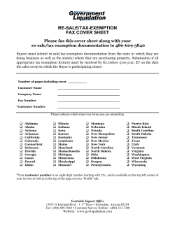


© Copyright 2026