
BACKGROUND INFORMATION DOCUMENT
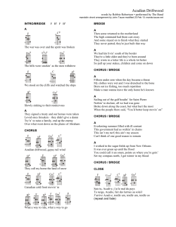
15 October 2014 BACKGROUND INFORMATION DOCUMENT THE PROPOSED MASHUNKA, MTATENI AND NGUBO LOCAL COMMUNITY ACCESS BRIDGE OVER THE TUGELA RIVER AND ASSOCIATED LINK ROAD, SITUATED WITHIN THE MSINGA LOCAL MUNICIPALITY, KWAZULU-NATAL EDTEA Reference: DC24/0011/2014: KZN/EIA/0001680/2014 1. INTRODUCTION Information is provided in terms of (i) the National Environmental Management Act, 1998 (Act No 107 of 1998), as amended, the Environmental Impact Assessment Regulations as published in Government Notice No. R. 543 of 2010, considering Government Notice No. R. 544 and 546; and (ii) the National Water Act, 1998 (Act No 36 of 1998) of the undertaking of a Basic Assessment process and an Integrated Water Use License Application (IWULA) respectively. Afzelia Environmental Consultants (Pty) Ltd has been appointed by Royal Haskoning DHV (RHDHV), on behalf of the KwaZulu-Natal Department of Transport to conduct an environmental impact assessment in the form of a Basic Assessment process, as well as an IWULA. 2. LOCALITY The proposed Mashunka, Mtateni and Ngubo local community access bridge over the Tugela River and associated link road are situated in central KwaZulu-Natal approximately 8 km west of Tugela Ferry town. Refer to Appendix A for the Locality Map. The proposed bridge and link road are situated in Mashunka, Mtateni and Ngubo local community areas within the Farm Mthembu 17484 under the jurisdiction of iNkosi Mthembu and therefore Ingonyama Trust Board. 3. PROJECT DESCRIPTION The construction of a bridge over the Tugela River and associated road infrastructure will link the Mashunka, Mtateni and Ngubo local communities, located on either side of the river. Refer to Appendix B and C for the Aerial Maps. Two (2) site / route alternatives are considered for the development; the geographical co-ordinates of the proposed development sites are indicated in Table 1 below: Table 1: Coordinates of Proposed Development Sites Site/Route alternative 1 (Preferred): Start Middle End 28o 30o 28º 30º 28º 44’ 24’ 44’ 23’ 45’ 43.66’’S 07.39’’E 40.93’’S 13.55’’E 13.23’’ S Site/Route alternative 2: 28º 30º 28º 30º 28º 43’ 21’ 44’ 21’ 44’ Afzelia Environmental Consultants (Pty) Ltd – Background Information Document 25.55’’S 35.06’’E 36.45’’S 36.07’’E 41.00’’S Page 1 30º 22’ 37.96’’ E 30º 20’ 51.63’’E Details of the proposed bridges and link roads are as follows: Site / Route alternative 1 (Preferred): This alternative entails the construction of a 3.3 km link road, starting at approximately 41.5 km on P280 Road south of the Tugela River, ending at approximately 4.5 km on D1272 Road north of the Tugela River. A 1.9 km portion of the 3.3 km road is an existing Type 4 dual lane gravel road located on the northern side of the Tugela River. This road will require major realignment. The remaining 1.4 km will be a new road starting north of the Tugela River, crossing the river and finishing south of the river. This link road (to be constructed) will be a dual lane gravel Type 4 standard road with a road width of 7 m to tie in with the existing road. At the Tugela River crossing point, a new bridge of the following specifications will be constructed: approximately 150 m in length (6 spans of 25 m each), comprising of post-tensioned precast beams, with a cast in-situ deck slab and reinforced by concrete wall type piers. The structure would comprise of 2 x 3.5 m wide lanes and a 1.5 m wide pedestrian walkway. Measured in a straight line the proposed bridge would be approximately 2.2 km west of the existing Tugela Ferry Bridge on main Road R33. Design of both the proposed road and the bridge includes associated stormwater infrastructure. Site / Route alternative 2: This alternative entails the construction of a 6.2 km link road, starting at approximately 37.1 km on P280 Road located south of the Tugela River, ending at approximately 5.85 km on D1284 Road north of the Tugela River. Of the 6.2 km length of the road, a 4.5 km portion is an existing 5 m wide Type 7 gravel road located on the northern side of Tugela River. Approximately 450 m of the 4.5 km section would require minor upgrading. The remaining 1.7 km will be a new road (0.9 km on the northern side and 0.8 km on southern side of the Tugela River). The link road to be constructed will be a gravel Type 7 standard road with a road width of 5 m to tie into the existing road. At the Tugela River crossing point, a new bridge of the following specifications will be constructed: approximately 175 m in length (i.e. 7 spans of 25 m each), comprising of post-tensioned precast beams, with a cast in-situ deck slab and reinforced by concrete wall type piers. The structure would comprise of 2 x 3.5 m wide lanes and a 1.5 m wide pedestrian walkway. According to the preliminary design report issued by RHDHV “a skew structure will be required in order to accommodate road geometric requirements”. Measured in a straight line the proposed bridge would be approximately 9.4 km west of the existing Tugela Ferry bridge on main Road R33. Design of both the proposed road and the bridge includes associated stormwater infrastructure. 4. DIRECTIONS TO SITE Site/Route alternative 1 (Preferred): From Tugela Ferry CBD drive west on R33. Turn right onto D1272 just before the Tugela Ferry Bridge. Follow the D1272 for approximately 4.5 km. The start of the site is the un-named road on the left. Site/Route alternative 2: From alternative 1, proceed on D1272 for 3.7 km then turn left onto D1284 and follow the road for 1.5 km. The start of the site is the un-named road on the left. 5. APPLICABLE LEGISLATION The construction of the Bridge and associated link road triggers Listed Activities captured in the EIA Regulations (2010) promulgated in terms of the National Environmental Management Act (NEMA) under Government Notice No. 544 and 546; as well as Section 21 (a), (c) and (i) of the National Water Act (Act No 36 of 1998) which requires a Water Use Licence. 5.1 National Environmental Management Act requirements The following table provides a summary of the Listed Activities in terms of the EIA Regulations 2010 that are triggered by the proposed development: Afzelia Environmental Consultants (Pty) Ltd – Background Information Document Page 2 Table 2: Summary of the Listed Activities Government Notice Number Activity Number No. R544 of June 2010 (Listing Notice 1) 11 No. R544 of June 2010 (Listing Notice 1) 18 No. R544 of June 2010 (Listing Notice 1) 22 No. R544 of June 2010 (Listing Notice 1) 39 No. R544 of June 2010 (Listing Notice 1) 40 Description of each Listed activity The construction of : i. canals; ii. channels; iii. bridges; iv. dams; v. weirs; vi. bulk storm water outlet structures; vii. marinas; viii. jetties exceeding 50 square metres in size; ix. slipways exceeding 50 square metres in size; x. buildings exceeding 50 square metres in size; or xi. infrastructure or structures covering 50 square metres or more Where such construction occurs within a watercourse or within 32 metres of a watercourse, measured from the edge of a watercourse, excluding where such construction will occur behind the development setback line. The infilling or depositing of any material of more than 5 cubic metres into, or the dredging, excavation, removal or moving of soil, sand, shells, shell grit, pebbles or rock from i. a watercourse; ii. the sea; iii. the seashore; iv. the littoral active zone, an estuary or a distance of 100 metres inland of the high-water mark of the sea or an estuary, whichever distance is the greaterbut excluding where such infilling, depositing, dredging, excavation, removal or moving is for maintenance purposes undertaken in accordance with management plan agreed to by the relevant environmental authority; or occurs behind the development setback line. The construction of a road, outside urban areas, i. With a reserve wider than 13.5 meters or, ii. Where no reserve exists where the road is wider than 8 meters, or iii. For which an environmental authorisation was obtained for the route determination in terms of activity 5 in Government Notice 387 of 2006 or activity 18 in Notice 545 of 2010. The expansion of i. Canals; ii. Channels; iii. Bridges; iv. Weirs; v. Bulk storm water outlet structures; vi. Marinas; Within a watercourse or within 32 meters of a watercourse, measured from the edge of a watercourse, where such expansion will result in an increased development footprint but excluding where such expansion will occur behind the development setback line. The expansion of i. Jetties by more than 50 square meters; ii. Slipways by more than 50 square meters; Afzelia Environmental Consultants (Pty) Ltd – Background Information Document Page 3 Government Notice Number Activity Number No. R544 of June 2010 (Listing Notice 1) 47 No. R546 of June 2010 (Listing Notice 3) 19 Description of each Listed activity iii. Building by more than 50 square meters iv. Infrastructure by more than 50 square meters Within a watercourse or within 32 meters of a watercourse, measured from the edge of a watercourse, but excluding where such expansions will occur behind the development setback line. The widening of a road by more than 6 meters, or lengthening of a road by more the 1 kilometer – i. Where the existing reserve is wider than 13.5 meters; or ii. Where no reserve exists, where the existing road is wider than 8 meters – Excluding widening or lengthening occurring inside urban areas. The widening of a road by more than 4 meters, or the lengthening of a road by more than 1 kilometre. ii. Outside urban areas, in: ii. Areas on the watercourse side of the development setback line of within 100 meters from the edge of a watercourse where no such setback line has been determined. The abovementioned activities contained in Listing Notice 1 and 3 of the Regulations promulgated in terms of the National Environmental Management Act (GN R. 544 and 546, of 18 June 2010) are subject to a Basic Assessment. 5.2 National Water Act requirements The following table provides a summary of water uses that require a Water Use Licence in terms of the National Water Act: Table 3: Summary of water uses that require a Water Use Licence Activity Number Section 21 (a) of NWA, 1998 Section 21 (c) of NWA, 1998 Section 21 (i) of NWA, 1998 Water Use Taking water from a water resource Impeding or diverting the flow of water in a watercourse. Altering the bed and banks of a watercourse or characteristics of a watercourse. Explanation / Definitions Taking water from a river, from underground or from any other water resource. A water resource includes a river, spring, pan, aquifer, wetland, lake or estuary. Impeding flow means the temporary or permanent obstruction or hindrance to the flow of water into watercourse by structures built either fully or partially in or across a watercourse. Diverting flow means a temporary or permanent structure causing the flow of water to be rerouted in a watercourse for any purpose. Altering the bed and banks means any change affecting the resource quality of the watercourse (the area within the riparian habitat or 1:100 year floodline, whichever is the greatest). 6. BASIC ASSESSMENT PROCESS The Environmental Impact Assessment (EIA) process is a comprehensive, independent assessment of all identified and potential environmental impacts. The aim of an EIA is to ensure that the development occurs in a sustainable manner and to formulate ways for reducing or mitigating any negative impacts of the project whilst enhancing its benefits. The findings and mitigation measures are recorded in the Environmental Management Programme (EMPr) which becomes a legally binding document on approval. Impacts will be determined through a process of public participation process (PPP), guidance from government authorities, specialist field assessments and impact modelling, and experience with similar projects. Afzelia Environmental Consultants (Pty) Ltd – Background Information Document Page 4 The following will take place during the Basic Assessment process (in no particular order): Detailed environmental investigations; Impact assessment and modelling; Information sharing with Interested and Affected Parties (I&APs) and authorities through notifications, Background Information Document (BID), and public meeting(s); Submission of the draft Basic Assessment Report (BAR) including the EMPr to the relevant authorities and I&APs for comment; Consolidating, addressing, and providing appropriate mitigation measures where necessary for all comments received; Submission of the final BAR including the EMPr to the relevant authorities and I&APs for comment; and Submission of the final BAR including the EMPr to the EDTEA for authorisation. 7. ENVIRONMENTAL SPECIALIST STUDIES TO BE UNDERTAKEN In order to quantify how and where a project may impact on the environment, specialist studies are required to inform the Basic Assessment process as well as the IWULA and provide supporting specialist data. The following specialist studies have been identified thus far and will be conducted during the EIA process: i. ii. iii. iv. v. vi. vii. viii. ix. x. Wetland Delineation and Functionality Assessment Wetland Rehabilitation Plan Ecological Assessment Aquatic Ecological Assessment Heritage Impact Assessment Social Impact Assessment Detailed Geotechnical Assessment 1:100 Year Floodline Assessment Stormwater Management Plan Construction Method Statement 8. WATER USE LICENSE PROCESS Due to the proposed development occurring within a 500 metre radius of a wetland and within the 1:100 year floodline of a watercourse, an IWULA is required to be submitted to the Department of Water and Sanitation Affairs (DWS) in terms of Section 21 (a), (c) and (i) in accordance with the National Water Act (NWA). The following figure outlines the WUL application and authorisation process: Afzelia Environmental Consultants (Pty) Ltd – Background Information Document Page 5 Figure 1: Water Use Licence application and authorisation process 9. PREMILINARY IMPACT ASSESSMENT The preliminary assessment of the draft design drawings for alternative 1 and the draft alignment of alternative 2 indicated the following potential impacts. Table 4: Preliminary impact assessment Item a. b. c. d. e. f. g. h. i. j. k. Impact Alternative 1 Loss of the cultivation land on either side of the Tugela River Definite Disturbance of numerous graves and grave yards situated along Definite the existing road to be realigned Relocation of homesteads Definite Disturbance of protected plants (i.e. Natural forest and Aloes) Definite Disturbance of the riparian habitat and wetland(s) Definite Relocation of the irrigation canal Definite Relocation of electricity service infrastructure Definite Increased stormwater effects Definite Disturbance to the current Sense of Place Definite Alteration of the river flow and riverine dynamics of the Tugela Possible River Alteration of the bed and banks of the Tugela River Definite Alternative 2 Possible Possible Possible Definite Definite Unlikely Unlikely Definite Possible Possible Definite 10. PUBLIC PARTICIPATION PROCESS (PPP) The PPP is a process in which stakeholders and I&APs are afforded an opportunity to comment on, or raise issues relevant to the construction activities and / or the EIA process. Stakeholders and I&APs are invited and urged to: Respond (by phone, fax, mail or e-mail) to the invitation to participate in the PPP; Complete and forward (mail, fax or e-mail) the attached registration and comment form to Afzelia Environmental Consultants; Afzelia Environmental Consultants (Pty) Ltd – Background Information Document Page 6 Attend the public meetings to be held during the course of the project; Contact the Environmental Assessment Practitioner (EAP) regarding any query, comment or request for further project information; and Review the draft and final BAR within the legislated review periods that will be stipulated in the advertisements as well as in notification letters. 11. RESPONSIBILITIES OF AN I&AP I&APs have a right to participate in this process by requesting further information or by informing the relevant consultant of concerns regarding the environment in relation to the project. In order to participate in the EIA process, an I&AP must: Register on the project database in order to receive detailed information regarding the EIA process (See Appendix D); Inform any other parties (neighbours, friends, colleagues, etc.) who may be interested and/or affected by the project about the EIA process and encourage involvement and participation; Ensure that any comments regarding the project are submitted within the timeframes that have been approved or set by the authorities, or within any extension of a timeframe agreed to by authorities and the applicant; and Disclose any direct business, financial, personal or other interest in the approval or refusal of the application for the project. 12. RESPONSIBILITIES OF PPP CONSULTANT In terms of the EIA Regulations, the PPP consultant has the following responsibilities: Engage the key stakeholders, Competent Authority and I&APs; Provide sufficient information regarding the project and associated impacts; Ensure that all issues raised are recorded and forwarded to the environmental specialists to address in their impact studies; and Facilitate a transparent process. You have been identified as a potential I&AP in this process and are therefore invited to participate in the project by registering. Your comments will ensure that all relevant issues are considered, documented and will assist in informed decision-making by the relevant authorities. Should you wish to register as an I&AP and/or receive additional information regarding the project, you are requested to complete the form below and email, fax, post or hand deliver it to Afzelia Environmental Consultants by 30 October 2014 as per the details provided in the registration and comment form. We invite all stakeholders and I&APs to participate freely and to submit any comments or information you feel may be useful. Afzelia Environmental Consultants (Pty) Ltd – Background Information Document Page 7 APPENDIX A: LOCALITY MAP Afzelia Environmental Consultants (Pty) Ltd – Background Information Document Page 8 APPENDIX B: AERIAL MAP FOR ALTERNATIVE 1 Afzelia Environmental Consultants (Pty) Ltd – Background Information Document Page 9 APPENDIX C: AERIAL MAP FOR ALTERNATIVE 2 Afzelia Environmental Consultants (Pty) Ltd – Background Information Document Page 10 APPENDIX D: I&AP REGISTRATION FORM THE PROPOSED MASHUNKA, MTATENI AND NGUBO LOCAL COMMUNITY ACCESS BRIDGE OVER THE TUGELA RIVER AND ASSOCIATED LINK ROAD, SITUATED WITHIN THE MSINGA LOCAL MUNICIPALITY, KWAZULU-NATAL Title Name Surname Company Designation Address Postal code Tel No. Fax No. Email Cell No. I would like to receive my notifications by (mark with X): Post Please indicate why you have interest in the abovementioned project? Email Fax Please write your comments and questions here: Please feel free to attach a separate document Please add any person you think may be an interested and affected party: Full Name Company Address Email Tel/ Cell No. PLEASE SEND YOUR REGISTRATION FORM AND COMMENTS TO: Company Afzelia Environmental Consultants (Pty) Ltd Contact person Mr Brian Mafela Address PO Box 37069, Overport, 4067 Tel No. 031 303 2835 Fax 086 692 2547 Email [email protected] Website www.afzelia.co.za Afzelia Environmental Consultants (Pty) Ltd – Background Information Document Page 11


© Copyright 2026