
Vermont Land and Water Conservation Fund Grant Program 2015
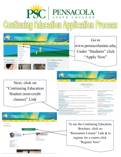
NEW: Pre-Application Due Date: October 31, 2014 Full Application Due Date: No Later Than 12:00 Noon February 16, 2015 Page 1 of 25 2015 Grant Application Vermont Land and Water Conservation Fund Grant Program Land and Water Conservation Fund History The Land and Water Conservation Fund was created by an Act of Congress in 1965 and is administered nationally by the Park Service, U.S. Department of the Interior. The creation of the fund paid homage to President John F. Kennedy, who had worked for the creation of perpetually available recreational opportunities. Since its creation, the Fund has enjoyed bi-partisan support by Congress and has invested public funds to purchase land for recreational purposes in urban and rural communities throughout the country. Projects typically leverage considerable other public and private resources. In Vermont, the Fund is administered by the Department of Forests, Parks and Recreation. Since 1965, the Fund has provided Vermont communities and state parks with more than $28,000,000 toward the acquisition, conservation, and development of outdoor recreation areas and facilities. More than 66,000 acres of outdoor recreation lands have been acquired and more than 500 separate recreation projects have been developed or rehabilitated. Eligible applicants are cities, towns, villages, school districts, fire districts, and inter-municipal districts established for recreational purposes. Application Submission Information NOTE (NEW THIS CYCLE): You must submit a pre-application (included) by October 31st, 2014 to [email protected] in order to schedule a site visit. Preferably, email (in .pdf format) Jessica Savage ([email protected]), a complete copy of your full application (including photographs, highlighted maps, etc.) no later than 12:00 Noon on February 16, 2015. Late or incomplete applications will not be considered for funding. Mailed applications must be received no later than 12:00 Noon on February 16, 2015. Address: Jessica Savage, Recreation Coordinator Land and Water Conservation Fund Vermont Department of Forests, Parks and Recreation 1 National Life Drive, Davis 2 Montpelier, VT 05620-3801 Any questions about the program should be directed to: Jessica Savage at 802-249-1230 or Craig Whipple at 802-343-5318. Applications and other information about the department’s grant programs can be found on-line at: www.vtfpr.org/reclwcf/index.cfm **Be sure to completely read both the 2015 Grant Application and the Application Supplement before preparing your application. Page 2 of 25 Part I: Pre-Application Form: Land and Water Conservation Fund – FY 2015 To Application Recipients, The LWCF application process requires that a pre-approval site inspection of a potential project be made by state staff. In order to properly schedule such inspections, we are requesting that if your community intends to submit a completed full application by the deadline of February 16, 2015, that you fill out the pre-application form below and return it no later than October 31, 2014 to [email protected] PLEASE NOTE: THIS DOES NOT CONSTITUTE A COMPLETED FULL APPLICATION If you have any questions concerning the site inspection or the application process, please contact Jessica Savage at 802-249-1230 or [email protected] Municipality: Contact Name: Address: Phone: E-mail: Proposed Federal Funding Request (note: LWCF is a 50-50 match program): Brief Project Narrative: (type of project, location, estimated cost, etc.) Please attach any maps, site plans and photos. Page 3 of 25 Vermont Land and Water Conservation Fund Grant Program Full Application Page 4 of 25 Project Summary Land and Water Conservation Fund 2015 Grant Application Please type all information on this form and do not refer to separate pages. The information provided in the first two pages is for administrative purposes and is not used to judge your application. 1. Project Name 2. Prior LWCF Project Number(s) List all prior LWCF project numbers and all park names associated with assisted site(s): 3. Local or State Project Sponsoring Agency (recipient or sub-recipient in case of pass-through grants): 4. Contact person, title Tel. # Fax # Mailing address E-mail address Town/City Zip Code Type of Project Acquisition 8. Development Estimated daily and annual use: This information is collected to be made available to National Park Service upon request. Please contact our office for ideas on how to calculate an estimate. Estimated # of people who will/do use this site daily 5. Combination: Acquisition/Development Estimated # of people who will/do use this site annually Project Description and Need (Please do not indicate “see attached”) Page 5 of 25 Park Name #1: County Name City Name Congressional Dist. GPS Coordinates (Deg./Min./Sec./Dir.) Latitude: Longitude: Fiscal Year: New 6(f) Acres at Park: Zip Code Total Number of 6(f) Acres at Park: 9. Demographics: Check all items proposed for development in this application’s scope of work. 00. Campgrounds 01 Tent Sites 02 RV/camper sites 03. Group campground 04. Day camp 00. Picnic Areas 01. Family site 02. Group shelter 00. Sports & Playfields 01. Gen purpose playfields 02. Baseball 03. Football 04. Tot lot/playground 05. Tennis courts 06. Basketball 07. Rifle/pistol range 08. Trap/skeet field 09. Archery range 10. Rodeo area 11. Track Facility 12. Skate board 13. Soccer 14. Other Courts 15. Softball 00. Golf Course 01. Regular 02. Par 3 03. Driving range 04. Regular 9 Hole 05. Miniature golf 06. Pitch and putt E. F. G. 00. Swimming Facilities 01. Pool 02. Wading Pool 03. Spray pool 04. Swimming beach 05. Bathhouse 00. Boating Facilities 01. Launch ramp 02. Berths 03. Boat lift 00. Fishing Facilities 01. Pier 02. Stream improvement 03. Fishing access H. 00. Trails 01. Hiking 02. Horse 03. Bicycle 04. Motorized 05. Natural 06. Exercise J. 00. Winter Sports Facilities 01. Ski lift 02. Ski slope 03. Ski jump 04. Sled/toboggan run 05. Skating rink 06. Ski trails 07. Snowmobile trails. 08. Warming hut Page 6 of 25 K. L. 00. Enclosed Shelter 01. Pool 02. Courts 03. Picnic 00. Sheltered Ice Rink M. 00. Hunting N. 00. Natural Area P. 00. Passive Parks Q. 00. Support Facility 01. Walkways 02. Site impr./landscaping 03. Utilities 04. Equipment 05. Roads 06. Parking 07. Lighting 08. Signs 09. Comfort station 10. Concession building 11. Maintenance building R. 00. Amphitheater/Band Shell S. 00. Lake Impoundment T. 00. Visitor Information Center U. 00. Interpretive Center V. 00. Other_________________ 10. Please list proposed accessibility components 11. Service area information (check all that apply) Neighborhood Multi-Neighborhood Regional Statewide Urban Suburban Rural Agricultural Undeveloped Industrial 12. User population ages (check all that apply) 0-2 years 6-12 years Adults 3-5 years Teens Seniors 13. Please indicate approximate distance to other outdoor recreation facilities Page 7 of 25 Part III A – Application Review Criteria Land and Water Conservation Fund 2015 Grant Application Re-state each question and answer each in narrative form. Include attachments to support the narrative if desired. a. Project planning (22 points) 1. How does the project relate to the recreation priorities described in the Key Findings and/or the Desired Conditions of the 2014-2019 Vermont Outdoor Recreation Plan? In order to receive credit, sponsors must clearly document and reference how their project addresses or relates to at least one priority. The Key Findings and Desired Conditions of the 2014-2019 Vermont Outdoor Recreation Plan are included in the Application Supplement. For each Key Finding, 0-4 points will be awarded. For each Desired Condition, 0-2 points will be awarded. A maximum of 12 points may be earned. (12 points) 2. How does the project address recreation issues or needs identified within local, regional, or other pertinent state planning documents? Show how this is part of the comprehensive plan of your community (i.e., Town Plan, Capital Plan, Community Plan). Consideration will be given to both the number of issues addressed by this project as well as the relative priority assigned to those needs within the plan(s). (10 points) b. Project Need and Public Involvement (13 points) 1. Is the project one where action must be taken due to public health issues, acquisition opportunity being lost, closure of a recreation facility, legal or statutory requirements, or other situations? Other than applying for this grant what steps has the community taken to address the need for this project? (5 points) 2. (8 points) Describe the planning process that led to the development of this proposal. Your narrative should address: a. How was the interested and affected public notified and provided opportunity to be involved in planning for and developing your LWCF proposal? Who was involved and how were they able to review the completed proposal, including any state, local, federal agency professionals, subject matter experts, members of the public and Indian Tribes. Describe any public meetings held and/or formal public comment periods, including dates and length of time provided for the public to participate in the planning process and/or to provide comments on the completed proposal. b. What information was made available to the public for review and comment? Did the sponsor provide written responses addressing the comments? If so, include responses a. Project Characteristics and Maintenance (35 points) 1. Does the project represent a cost-efficient use of funds? Is there a less expensive alternative site for this project? Could an existing facility or resource meet the need? Please explain. (5 points) Page 8 of 25 2. Does the project minimize operations and maintenance costs? What are the long-term operation and maintenance costs associated with this project and how will the sponsor provide for these costs? No points will be awarded for sponsors who fail to specify and address expected future costs, including replacement costs. Addressing long-term maintenance is very important. (10 points) 3. How does the community address issues related to climate change in the planning, implementation, and long-term stewardship of the project? How does the project’s location and overall accessibility relate to its service area? Projects that are conveniently located and easily accessible to their primary user groups will be awarded the most points. The use of energy conservation/efficiency measures for recreation area access, design, and implementation of the project are important. Such aspects as unique design features, creative agreements for funding, and other innovative features will be given priority. (10 points) 4. Will the project enhance or preserve unique natural, cultural, or recreation resources or facilities? Consideration will be given to both the significance and quantity of unique features, which will be protected or enhanced with this project. (5 points) 5. Describe how your project meets or exceeds the minimum standards required for accessibility to meet the needs of the elderly, low-income, physically challenged persons, or other special population groups. (5 points) b. Overall Quality of Application/Process (30 points) 1. Consideration will be given to the Sponsor’s: (a) (b) (c) Quality and completeness of the grant application (5 points) Results of pre-award inspection/site visit (10 points) Presentation to the Land and Water Conservation Fund (LWCF) ranking committee (15 points) Page 9 of 25 Part III B – Proposal Descriptions Land and Water Conservation Fund 2015 Grant Application Step 1. a. For an Acquisition Project 1. Provide a brief narrative about the proposal that provides the reasons for the acquisition, the number of acres to be acquired with LWCF assistance, and a description of the property. Describe and quantify the types of existing resources and features on the site (for example, 50 acres wetland, 2,000 feet beachfront, 200 acres forest, scenic views, 100 acres riparian, vacant lot, special habitat, any unique or special features, recreation amenities, historic/cultural resources, hazardous materials/contamination history, restrictions, institutional controls, easements, rights-of-way, above ground/underground utilities, including wires, towers, etc.). 2. How and when will the site be made open and accessible for public outdoor recreation use (signage, entries, parking, site improvements, allowable activities, etc.)? 3. Describe development plans for the proposal for the site(s) for public outdoor recreation use within the next three (3) years. 4. Address each item in “D” below. b. For a Development Project 1. Describe the physical improvements and/or facilities that will be developed with federal LWCF assistance, including a site sketch depicting improvements, where and how the public will access the site, parking, etc. Indicate entrances on 6(f) map. Indicate to what extent the project involves new development, rehabilitation, and/or replacement of existing facilities. 2. When will the project be completed and open for public outdoor recreation use? 3. Address each item in “D” below. c. For a Combination Project 1. For the acquisition part of the proposal: (a) Provide a brief narrative about the proposal that provides the reasons for the acquisition, number of acres to be acquired with LWCF assistance, and describes the property. Describe and quantify the types of existing resources and features on the site (for example, 50 acres wetland, 2,000 feet beachfront, 200 acres forest, scenic views, 100 acres riparian, vacant lot, special habitat, any unique or special features, recreation amenities, historic/cultural resources, hazardous materials/contamination history, restrictions, institutional controls, easements, rights-of-way, above ground/underground utilities, including wires, towers, etc.). (b) How and when will the site be made open and accessible for public outdoor recreation use (signage, entries, parking, site improvements, allowable activities, etc.)? Page 10 of 25 (c) Describe development plans for the proposed for the site(s) for public outdoor recreation use within the next three (3) years. 2. For the development part of the proposal: (a) Describe the physical improvements and/or facilities that will be developed with federal LWCF assistance, including a site sketch depicting improvements, where and how the public will access the site, parking, etc. Indicate entrances on 6(f) map. Indicate to what extent the project involves new development, rehabilitation, and/or replacement of existing facilities. (b) When will the project be completed and open for public outdoor recreation use? 3. Address each item in “D” below. d. Additional items to address 1. Will this proposal create a new public park/recreation area where none previously existed and is not an addition to an existing public park/recreation area? Yes No (go to #2) 2. (a) What is the name of the pre-existing public area that this new site will be added to? (b) Is the pre-existing public park/recreation area already protected under Section 6(f)? Yes No If no, will it now be included in the 6(f) boundary? Yes No 3. What will be the name of this new public park/recreation area? 4. (a) (b) Who will hold title to the property assisted by LWCF? Who will manage and operate the site(s)? What is the sponsor’s type of ownership and control of the property? Fee simple ownership Less than fee simple. Explain: Lease. Describe lease terms including renewable clauses, # of years remaining on lease, etc. Who will lease area? Submit copy of lease with this PD/ESF. (See LWCF Manual for program restrictions for leases and further guidance.) 5. Describe the nature of any rights-of-way, easements, reversionary interests, etc. to the Section 6(f) park area. Indicate the location on 6(f) map. Do parties understand that a Section 6(f) conversion may occur if private or non-recreation activities occur on any pre-existing rightof-way, easement, leased area. 6. Are overhead utility lines present, and if so, explain how they will be treated per LWCF Manual (see http://www.nps.gov/ncrc/programs/lwcf/manual/lwcf.pdf) 7. As a result of this project, describe new types of outdoor recreation opportunities and capacities, and short and long term public benefits. Page 11 of 25 8. Explain any existing non-recreation and non-public uses that will continue on the site(s) and/or proposed for the future within the 6(f) boundary. 9. Describe the planning process that led to the development of this proposal. Your narrative should address: (a) How was the interested and affected public notified and provided opportunity to be involved in planning for and developing your LWCF proposal? Who was involved and how were they able to review the completed proposal, including any state, local, federal agency professionals, subject matter experts, members of the public and Indian Tribes. Describe any public meetings held and/or formal public comment periods, including dates and length of time provided for the public to participate in the planning process and/or to provide comments on the completed proposal. (b) What information was made available to the public for review and comment? Did you provide written responses addressing the comments? If so, include responses. 10. How does this proposal implement statewide outdoor recreational goals as presented in the Statewide Comprehensive Outdoor Recreation Plan (SCORP) (include references). 11. List all source(s) and amounts of financial match to the LWCF federal share of the project. The value of the match can consist of cash, donation, and in-kind contributions. The federal LWCF share and financial matches must result in a viable outdoor recreation area and not rely on other funding not mentioned here. Other federal resources may be used as a match if specifically authorized by law. Source Type of Match Value $ $ $ 12. Is this LWCF project scope part of a larger effort? If so, briefly describe the larger effort, funding amount(s) and source(s). This will capture information about partnerships and how LWCF plays a role in leveraging funding for projects beyond the scope of this federal grant. 13. List all required federal, state, and local permits/approvals needed for the proposal and explain their purpose and status. Page 12 of 25 Step 2. a. Summary of Previous Environmental Review To avoid duplication of effort and unnecessary delays, describe any prior environmental review undertaken at any time and still viable for this proposal or related efforts that could be useful for understanding potential environmental impacts. Consider previous local, state, federal (e.g. HUD, EPA, USFWS, FHWA, DOT) and any other environmental reviews. At a minimum, address the following: 1. Date of environmental review(s), purpose for the environmental review(s) and for whom they were conducted. 2. Description of the proposed action and alternatives. 3. Who was involved in identifying resource impact issues and developing the proposal including the interested and affected public, government agencies, and Indian tribes. 4. Environmental resources analyzed and determination of impacts for proposed actions and alternatives. 5. Any mitigation measures to be part of the proposed action. 6. Public comment periods (how long, when in the process, who was invited to comment) and agency response. 7. Any formal decision and supporting reasons regarding degree of potential impacts to the human environment. Page 13 of 25 Part IV – Project Cost Estimate & Long Term Maintenance Land and Water Conservation Fund 2015 Grant Application This section should document all costs and contribute to the completion of the proposed project. This is not limited to expenses paid out but includes in-kind labor and/or donated materials or services. Include a brief description of each item and its estimated cost in the space provided. Enter $0 for items not applicable to this project. Remember: This is a reimbursable grant program. The sponsor must have the means to pay for expenses up front and then request reimbursement based on actual expenditures. More information about completing this section of the application can be found in the Application Supplement. Cost category/item A. Grant administration 1. Volunteer and staff wages 2. Cost $ Expenses $ Total $ B. Construction design and engineering 1. $ 2. $ 3. $ Total $ C. On-site construction labor 1. Skilled Labor $ $ 2. Unskilled Labor (minimum wage) $ Total $ D. Construction equipment 1. $ 2. $ Total $ Page 14 of 25 E. Materials 1. $ 2. $ 3. $ 4. $ Total $ F. Other expenses not included above 1. $ 2. $ 3. $ Total $ G. Summary of total project costs and funding sources Total All Costs Subtract total sponsor match (Use total from page 15) At ____% Total grant request At ____% Total H. $ $ ($ ) $ In the space provided, specify long-term maintenance costs and how each will be paid for. 1. $ 2. $ 3. $ 4. $ 5. $ Total $ Page 15 of 25 Part V – Sponsor’s Match Summary Land and Water Conservation Fund 2015 Grant Application List sources of sponsor match below. This summary shows how applicants plan to match this grant. It is understood that this plan can change throughout the application process and even throughout completion of the project. It is important that our office be aware of these changes to ensure they are eligible. Should a part of your source of match change, you will still be required to come up with the same value of match. Be sure to provide supporting details of where match is coming from on each line, then enter the value of the match contribution in the “Value” column. Indicate whether any grants are pending or confirmed and the approximate date of confirmation. Attach confirming letters or memos from the grants proposed for match. More information about sponsor match items and how to calculate their value can be found in the Application Supplement. Note if Donation or In-Kind Source of match Value 1. $ 2. $ 3. $ 4. $ 5. $ 6. $ 7. $ 8. $ 9. $ 10. $ 11. $ 12. $ 13. $ 14. $ 15. $ Add items 1-15 above for Total sponsor match $ Page 16 of 25 Part VI – Historical, Archaeological and Environmental Reviews Land and Water Conservation Fund 2015 Grant Application The following information is used to assist in the assessment of cultural and natural resources that may be impacted by your project. See Application Supplement for more information about completing this section. A. ENVIRONMENTAL RESOURCES Indicate potential for adverse impacts. Use a separate sheet to clarify responses per instructions for Part A on page 9. 1. Geological resources: soils, bedrock, slopes, streambeds, landforms, etc. 2. Air quality 3. Sound (noise impacts) 4. Water quality/quantity 5. Stream flow characteristics 6. Marine/estuarine 7. Floodplains/wetlands 8. Land use/ownership patterns; property values; community livability 9. Circulation, transportation 10. Plant/animal/fish species of special concern and habitat; state/ federal listed or proposed for listing 11. Unique ecosystems, such as biosphere reserves, World Heritage sites, old growth forests, etc. 12. Unique or important wildlife/ wildlife habitat 13. Unique or important fish/habitat 14. Introduce or promote invasive species (plant or animal) 15. Recreation resources, land, parks, open space, conservation areas, rec. trails, facilities, services, opportunities, public access, etc. Most conversions exceed minor impacts 16. Accessibility for populations with disabilities 17. Overall aesthetics, special characteristics/features 18. Historical/cultural resources, including landscapes, ethnographic, archeological, structures, etc. Attach Not ApplicableResource does not exist No/Negligible Impacts-Exists but no or negligible impacts Page 17 of 25 Minor Impacts Impacts Exceed Minor EA/EIS required More Data Needed to Determine Degree of Impact EA/EIS required SHPO/THPO determination. 19. Socioeconomics, including employment, occupation, income changes, tax base, infrastructure 20. Minority and low-income populations 21. Energy resources (geothermal, fossil fuels, etc.) 22. Other agency or tribal land use plans or policies 23. Land/structures with history of contamination/hazardous materials even if remediated 24. Other important environmental resources to address. 3. Historic Preservation Is this a proposal involving any rehabilitation, demolition, removal, or use of a structure or building which is more than 50 years old? If yes, include photographs as appropriate. Yes No Does the project include excavation within a floodplain or within 200 feet of a river or stream? Yes No Does the project include a stream crossing? If yes, describe on separate page, including width, length, ground disturbance, and depth of excavation. Yes No Are there any cellar holes, foundations, mill ruins, historic ruins, or areas of historic importance in the project area (i.e. historic roads or other historic features)? If yes, please describe on a separate page. Yes No Do you know of any Native American sites or artifacts in the project area? Yes No Is the proposed project located in a National Historic District? Yes No 4. Status of Permits Permit Specialists are available in State regional offices to answer your questions about the permit process. The Permit Specialist will advise you about needed state permits and will prepare a Project Review Sheet. The Project Review Sheet is a preliminary determination of not only environmental permits, but any state permits your project may need. It lists the agencies and departments and provides contact information. Knowing all of the permits required before you begin your project can prevent costly delays, saving you time and money. Has a Permitting Specialist at your Regional Environmental Office been contacted (contact information can be found in the appendix of the Application Supplement)? Be sure you request a Page 18 of 25 Project Review Sheet before January 15th to ensure you receive it before submitting your application. Yes No If Yes, give the status of any permits or clearances deemed necessary. If no, please explain: New development may require an environmental assessment by the applicant. Has a review for any of the following items been initiated for all or a part of this project? If so, please submit documentation with application to help facilitate the approval process. Categorical Exclusion Environmental Assessment Environmental Impact Statement Historic Preservation (Section 106) Clearance Yes Yes Yes Yes Page 19 of 25 No No No No Part VII – Sponsor Resolution to Apply for LWCF Funds Land and Water Conservation Fund 2015 Grant Application RESOLUTION of the __________________________________________ (hereinafter referred to as “Sponsor”) approving the application for Federal Land and Water Conservation Funds for project entitled ______________________________________________________ (hereafter referred to as “Application”). WHEREAS, the Congress under Public Law 88-578 has authorized the establishment of a Federal Land and Water Conservation Fund Grant-In-Aid Program, providing matching funds to the State of Vermont, its political subdivisions and Indian Tribes for acquiring lands and developing facilities for public outdoor recreation purposes; and WHEREAS, the Vermont Department of Forests, Parks and Recreation (FPR) is responsible for the administration of the program within the State, setting up necessary rules and procedures governing applications to FPR; and WHEREAS, the proposed project application must be consistent with the current Vermont Recreation Plan; and NOW, THEREFORE, BE IT RESOLVED that the Sponsor hereby: 1. APPROVES the filing of an application for Federal Land and Water Conservation Fund assistance; understanding that if funded by LWCF, the land for the project is bound in perpetuity for recreational purposes; and 2. CERTIFIES that Sponsor will comply with all appropriate state and federal regulations, policies, guidelines, and requirements as they relate to the preliminary and final applications and with grant administration, in particular with regard to project boundaries and permanent control and tenure of the project site; and 3. CERTIFIES that Sponsor has matching funds in the amount of $_____________ and can finance 100 percent of the project, up to half of which can be reimbursed by a Land and Water Conservation Fund grant; and 4. CERTIFIES that the project is compatible with the land use plans of the Sponsor; and 5. APPOINTS _____________________________________________________ (Name(s)/Title(s)) as agent of Sponsor to conduct all negotiations, execute and submit all documents including, but not limited to, applications, agreements, amendments, billing statements, and so on which may be necessary for the completion of the aforementioned project. PASSED, ADOPTED AND APPROVED by the Sponsor _________________________ this day of____________________, 2010. ____________________________________________ (Signature of Authorized Representative, Title) Page 20 of 25 Part VII – Map Guidelines Land and Water Conservation Fund 2015 Grant Application NOTE: Refer to the Application Supplement for additional information on 6(f)(3) boundary maps. Maps are critical components of your application. The accurate, complete, and clear cartographic communication of your project in geographic and political context will allow: Ranking Committee to fully understand and fairly assess your project Environmental and archaeological clearance reviews to occur efficiently Public accessibility Perpetual legal protection of the designated 6(f)(3) recreation area Each project must submit the following maps: Geographic Location Map (see table below for required map elements) Site Plan Map (see table below for required map elements) 6(f)(3) Legal Boundary Map (see table below for required map elements) Note: The Site Plan Map and the 6(f)(3) Legal Boundary Map may be combined if all components can be cleanly and clearly presented. In this case, the map should be titled, “Site Plan and 6(f)(3) Legal Boundary Map for Project Name.” PLEASE NOTE THAT THE SPONSOR MUST SIGN THE 6(f) LEGAL BOUNDARY MAP. It is important to understand the 6(f)(3) Legal Boundary Map is the proposed area to be developed or acquired with LWCF grant money. This area will be protected under Section 6(f)(3) of the LWCF Act, which states that property acquired or developed with LWCF money shall not be converted to uses other than public outdoor recreation. The protection is in perpetuity. The boundary area is sometimes an entire parcel or multiple parcels; other times it may be a portion of a parcel. The recreation area must be capable of providing viable public recreation without reliance on adjoining areas not identified in the project scope. Non-recreational facilities should not be included. For example, a school building, town maintenance building, or community center would be excluded along with a sufficient buffer (50 feet) to accommodate potential expansion. Structures directly related to recreation may be included. (See Application Supplement for lists of eligible and ineligible facilities). Basic Cartographic Elements Map Title (see examples under map types) Date of Map North Arrow Appropriate Scale Map Legend (specify “existing” vs. “proposed” Map Type Geographic Location Map (Used to navigate to site within its community and for environmental and archaeological reviews) Map Type Site Plan Map (Used to show a detailed layout of proposed and existing structures Map Elements Basic Cartographic Elements Title: “Geographic Location Map for Project Name” Roads 100 ft contours Town/County Boundaries Potentially Significant Natural Communities (if known) Potentially Significant Archaeological Areas (if known) Waterways/bodies Prominent landmarks Box with simple directions Map Elements Basic Cartographic Elements Title: “Site Plan Map for Project Name” Existing and proposed structures and development Page 21 of 25 and development) Map Type 6(f)(3) Legal Boundary Map Map Elements Basic Cartographic Elements Title: “6(f)(3) Legal Boundary Map for Project Name” Known easements, deed restrictions, interests held by others Ownership parcel boundary 6(f)(3) Legal Boundary area Sufficient legal references of 6(f)(3) Legal Boundary area for identification and protection (deed references, adjoining ownerships, adjoining natural water bodies, metes/bounds and/or measurements from permanent locators) Measurements for at least some straight boundary lines Existing proposed structures and development Roads (public access must be clear) Waterways/bodies Signature box with space for the project’s authorized official’s printed name, signature, and date Signature box for State of Vermont’s authorized official’s printed name, signature, and date Acreage box with number of acreage in the 6(f)(3) Legal Boundary area Box with GPS (latitude, longitude) coordinates in degree, minutes, seconds format. (Used to provide legal documentation of the protected recreation area) Site amenities Roads Waterways/bodies Note: The Site Plan Map and the 6(f)(3) Legal Boundary Map may be combined if all components can be cleanly and clearly presented. In this case, the map should be called, “Site Plan and 6(f)(3) Legal Boundary Map for Project Name.” Page 22 of 25 Page 23 of 25 Page 24 of 25 Page 25 of 25


© Copyright 2026