
NEWSLETTER • ISSUE 5
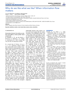
NEWSLETTER
2014 NOVEMBER • ISSUE 5
TRANSMIT - Training Research and Applications Network to Support the Mitigation of Ionospheric Threats, an FP7 Marie Curie Initial Training Network. The project addresses in
particular ionospheric threats to Global Navigation Satellite Systems (GNSS) and related applications, in areas such as civil aviation, marine navigation and land transportation.
www.transmit-ionosphere.net
INSIDE THIS ISSUE
“The Radio Occultation (RO) technique has now more than four decades of history and started with NASA’s planetary exploration missions. Main results of
the application of this technique are the retrieval of accurate profiles of refractivity, temperature, pressure and water vapour in the neutral atmosphere
and electron density in the ionosphere”.
The global coverage offered by two RO planned missions (EUROPEAN and USA/TAIWAN constellations) will improve the worldwide capability to
monitor the ionosphere from space and benefit, among others, the TRANSMIT science-services-users community, as evidenced in the article
by Riccardo Notarpietro from EUMETSAT, Darmstadt, Germany and Politecnico di Torino, Turin, Italy. TRANSMIT’s Early Stage Researchers
(ESR) Muhammad Mubasshir Shaikh, Tommaso Panicciari and Marko Vuckovic tell us about their ongoing studies on RO ionospheric
monitoring, ionospheric imaging, and ionospheric scintillation effects on GNSS.
NEWS
The TRANSMIT final open event will be held 17 and 18 November 2014 at Liege (Belgium), Palais des Congrès, within the 11th European
Space Weather Week (ESWW11), whereby TRANSMIT is inserted into the session entitled “Modelling the Earth's ionosphere and solutions
to counter ionospheric threats to GNSS applications”. The conference will also kindly host the TRANSMIT splinter session, which will take
place Tuesday 18 November (14.00-15.30) at the Auditorium Rogier, and will focus on presentation and open discussion on the TRANSMIT
prototype. See more in the Update/Status section of the newsletter.
SAD NEWS
We were deeply saddened by the news that Kees de Jong from Fugro Intersite B.V. (The Netherlands) suddenly passed away on Friday
31st October 2014 from brain hemorrhage. He was an unconditional supporter of the TRANSMIT project and became not only a fantastic
professional advisor to all of us, but also a great friend and colleague. He was the author of the Expert’s Voice article of the TRANSMIT
newsletter issue N.2 (May 2013), in which he insightfully discussed the impact of the ionosphere in precise offshore GNSS positioning.
He will be deeply missed by all who had the privilege to meet him, and especially by all involved in TRANSMIT. We will be forever indebted to him. Our thoughts are with his family at this sad moment.
The TRANSMIT Consortium
Update
Status
Marcio Aquino
Hello all and welcome to the November 2014 issue of
the TRANSMIT newsletter! Following on from our previous issue, the project has now concentrated on the
development of the TRANSMIT prototype demonstrator
and its web interface. As the fellows approach the end
of their research projects (and some of them have already been awarded their PhD!), the demonstrator has
evolved to incorporate the most recent results of their
work, through specific links that lead to the topics of
their research and showcase how they can be exploited
to assist users in countering the effects of a perturbed
ionosphere. To that effect we are very excited to give
you first hand the link to our web interface:
www.transmit-prototype.net!
As a way to give you a hint before you click on and
experience it live, here is what the home page looks
Figure 1 • Home page of the TRANSMIT demonstrator
Figure 2 • “Positioning Accuracy” tool of the TRANSMIT demonstrator
like (Fig. 1). Behind each of the icons on the home page
is the result of 3 years hard work of the TRANSMIT
fellows towards achieving this combined set of tools
that represent the project’s main research outcome.
Clicking on the icons you will find the tool description,
examples of processing results and (in some cases) a
live demo. As the project ends in Feb 2015, the web
interface is still undergoing further improvement and
will in the meantime gradually progress towards its
final form, therefore some of the tools not being fully
implemented as yet. But we are in no doubt that you
will have an exciting experience by trying out what is
already there.
[continues to page 3]
TRAINING RESEARCH AND APPLICATION NETWORK TO SUPPORT THE MITIGATION OF IONOSPHERIC THREATS
NEWSLETTER
THE EXPERT’S VOICE
2014 NOVEMBER • ISSUE 5
Ionospheric
monitoring
by means of
GNSS Radio
Occultation:
history,
potentiality
and future
Riccardo Notarpietro1,2
1
2
EUMETSAT, Darmstadt, Germany
Politecnico di Torino, Turin, Italy
2
GNSS Radio Occultation (RO) certainly deserves
to be defined as one of the most challenging
remote sensing techniques for the monitoring
of the atmosphere from space. The principle is
simple: when a radio frequency signal emitted by a
spacecraft passes through an intervening planetary
atmosphere before arriving at the receiver, it is
delayed and the ray path it follows is bent because
of atmospheric refraction. Phase and amplitude
measurements collected by suitable receivers on
board an orbiting satellite, normally placed on a
Low Earth Orbit (LEO), allow the retrieval of the
atmospheric parameters (in form of vertical profiles)
causing such refraction effects.
The RO technique has now more than four decades
of history and started with NASA’s planetary
exploration missions. The implementation of
the GPS system gave an opportunity for a global
monitoring of the Earth's atmosphere by RO [1].
Main results of the application of this technique
are the retrieval of accurate profiles of refractivity,
temperature, pressure and water vapour in the
neutral atmosphere [2], and electron density in the
ionosphere [3, 4]. For a more complete history of
GNSS RO see [5]. When a RO instrument tracks a
GPS signal as it is occulted by Earth's atmosphere, it
records the carrier phase change on the microwave
links at L1 and L2 with millimeter-scale precision.
After removal of the effects of the relative motion
between the GPS and the LEO satellites and of
the effects of clock drifts in the transmitter and
Figure 1 • Geographical distribution (left: latitude; right: longitude) of expected ionospheric soundings for
one of the METOP-SG (top) and COSMIC-2 (bottom) receivers. The figure shows the geolocations of occultation
points placed at 80 km height – Ionospheric sounding will start (end) for rising (setting) occultations from (to)
this point. Courtesy for providing the data: Axel von Engeln and GRAS TEAM @ EUMETSAT
receiver, the remaining residual phase is due to
the atmosphere only. If the signals cross only
ionospheric layers, such residual phases are directly
proportional to the total electron content (TEC). In
a RO configuration, data are collected from both the
zenith antenna normally available for navigation
purposes and the occultation antennas (placed in
the velocity and antivelocity directions). Therefore,
TEC data from positive and negative elevation angles
can be made available. For a LEO satellite placed at
an orbit of 800 km, TEC from the zenith antenna will
be mainly generated by the topside ionosphere and
plasmasphere, while TEC evaluated from negative
elevation angles will take into account all the
ionospheric effect characterizing a limb sounding
geometry below the satellite orbit.
All these TEC observations have demonstrated to
provide a benefit in several fields for:
• Space weather applications [6] (see also the
good overview provided in [7]);
• Monitoring the layered structure of the
ionosphere [8], up to identify the occurrence
frequency, seasonal maps and irregularities of
the sporadic E layer (see the review in [9] and
references therein);
• Data assimilation: in this case the higher
vertical resolution of limb sounding
observations (close to 1 km) certainly
represents an added value with respect to the
standard ground based observations [10];
• Ionospheric imaging: both kind of TEC data
have been used to image the 3D-4D topside
ionosphere and plasmasphere [11];
• Monitoring scintillation activity by
means of the observed signal-to-noise
intensity fluctuations of the GPS signals [12];
• Retrieving of vertical profiles of electron
density from the LEO altitude to the bottom of
the ionosphere, considering TEC observations
with negative elevations [13].
The first of a series of opportunities to demonstrate
the RO concept came with the GPS-MET investigation
led by the Universities Corporation for Atmospheric
Research (UCAR) with funding from NSF, NOAA, and
NASA [14]. The extraordinary success of the GPSMET concept mission (1995) had inspired a series
of other RO missions. The era of the operational
use of Radio Occultation observations for weather
and climate monitoring started in 2001 with the
Challenging Minisatellite Payload (CHAMP) and the
twin Gravity Recovery and Climate Experiment
(GRACE) missions (in 2002). In 2006, USA/Taiwan
cooperation launched the Formosa Satellite
Mission-3/Constellation Observing System for
Meteorology, Ionosphere, and Climate (FORMOSAT-3/
COSMIC) [15], the first satellite constellation for
Radio Occultation sounding. Contemporaneously
Europe launched the first of three MetOp satellites
that currently form the EPS - EUMETSAT Polar
System [16]. All these MetOp satellites (MetOp-A
and B were launched respectively in 2006 and
2012, while MetOp-C is expected to be launched in
2017) carry on board, among other sensors, a Radio
Occultation payload (the GRAS receiver [17]).
What about the future? Two big missions are
currently planned and scheduled to be launched
starting from 2018.
[continues to page 3]
TRAINING RESEARCH AND APPLICATION NETWORK TO SUPPORT THE MITIGATION OF IONOSPHERIC THREATS
NEWSLETTER
3
2014 NOVEMBER • ISSUE 5
Update
Status
[continues from page 1]
Hoping not to spoil your visit to the site, we would like
nevertheless to just briefly show you what you will find
if for instance you opt to explore the ‘Positioning Accuracy’ tool (Fig. 2).
This tool, developed by TRANSMIT fellow Peter Kieft, is
dedicated to provide different solutions aiming to mitigate the effects of ionospheric scintillation on GNSS
positioning. The user can select different strategies for
comparison, as well as a time span and either a low or
high latitude station. For now only a limited number of
case studies has been considered for the purpose of
demonstrating the tool capability.
Showcasing these tools is the main objective of the
prototype demonstrator and the web interface. It is the
proof of concept and the blueprint for a potential real
world service to be developed in the future. We will be
very keen to have your feedback on our demonstrator
and web interface.
We are also glad to confirm that TRANSMIT will have a
strong presence in the session entitled “Modelling the
Earth's ionosphere and solutions to counter ionospheric
threats to GNSS applications” at the 11th European Space
Weather Week (ESWW) in Liege, Belgium, 17-21 November
2014. Please have a look at the program at http://www.
stce.be/esww11/. A dedicated TRANSMIT splinter session
is also confirmed at the conference, and will take place
on 18 November at 14:00PM.
Finally, as announced in our last issue, the proceedings of the TRANSMIT 2014 Workshop that took place
in Torino earlier this year are now available through
open access publishers InTech, in the form of a book
titled “Mitigation of Ionospheric Threats to GNSS: an
Appraisal of the scientific and technological outputs
of the TRANSMIT project”, please visit: http://www.
intechopen.com/books/mitigation-of-ionosphericthreats-to-gnss-an-appraisal-of-the-scientific-andtechnological-outputs-of-the-transmit-project
.
Have a nice reading and we hope to see you in Liege!W
THE EXPERT’S VOICE
[continues from page 2]
One will be managed by ESA/EUMETSAT.
This is the EPS-Second Generation, the follow on from
the EPS missions. It will be made up of 6 satellites
launched on a polar orbit at 815 km height and
equipped with the new state of the art European
GNSS-Radio Occultation receiver.
The other, COSMIC-2, the follow on from FORMOSAT-3/
COSMIC, will be managed by USA/Taiwan cooperation
and will be made up of two 6-satellites constellations.
The first constellation will be launched in a low
inclination and lower height orbit (24°, 520 km
height). The second (actually only planned but not
Further Reading
[1] Y unck T.P. et al., The role of GPS in precise Earth
observation, Position, Location and Navigation Symposium,
IEEE PLANS '88, doi: 10.1109/PLANS.1988.195491, 1988.
[2] Kursinski E.R. et al., Observing Earth’s atmosphere with
radio occultation measurements using Global Positioning
System. J. Geophys. Res., 102, 23,429–23,465, 1997
[3]G.A., and L. J. Romans, Ionospheric electron density
profiles obtained with the Global Positioning System:
Results from the GPS/MET experiment, Radio Sci., 33,
175-190, 1998.
[4] J akowski N. et al., Radio occultation techniques for
probing the ionosphere, Annals of Geophysics, 47, 10491066, doi:10.4401/ag-3285, 2004.
yet funded), on a higher inclination orbit (72°, 750
km height). Both missions will provide RO data in
near real time for both neutral atmosphere and
ionosphere soundings (for the EPS-SG case the
timeliness requirement to make products available
is 70 min from the observation). GNSS-Radio
Occultation receivers on both constellations will
be characterized by improved tracking strategies/
algorithms and improved sampling rates (up to 250
Hz for the EPS-SG). As a baseline, EPS-SG receivers
will be able to track modernized GPS (GPS-M) and
GALILEO signals while COSMIC-2 receivers will be
developed considering GPS-M and GLONASS signals
[5] Y unck T.P.et al., A History of GPS Sounding. Terrestrial,
Atmospheric and Oceanic Sciences, 11, 1-20, 2000.
(we are talking about ~1200 occultations/day/
receiver). In both cases, receivers will be prepared
for correctly handling all the other GNSS signals
(doubling the expected number of occultations/day).
Just to provide an idea of the expected potentiality
in observing the ionosphere, Fig. 1 shows how good
the global coverage assured by the two EUROPEAN
and USA/TAIWAN constellations will be. In this figure,
one month of simulated geographical distributions
of ionospheric occultations are shown, considering
only one of the COSMIC-2 satellites and one of the
EPS-SGsW
meteor and wind shear information, J. Geophys. Res.
Atmos., 119, 4568-4579, doi:10.1002/2013JD020798, 2014.
radio occultation data in the ionosphere, Radio Sci., 34,
949-966, doi: 10.1029/1999RS900034,1999.
[6] J akowski N. et al., Space weather monitoring by GPS
measurements on board CHAMP, Space Weather, 5,
S08006, doi:10.1029/2006SW000271, 2007.
[10] Yue X., et al., Data assimilation retrieval of electron
density profiles from radio occultation measurements,
J. Geophys. Res., 116, doi:10.1029/2010JA015980, 2011.
[14] Ware, R., et al., GPS sounding of the atmosphere from
low Earth orbit - preliminary results, Bull. Am. Meteorol.
Soc., 77, 19-40, doi: 10.1175/1520-0477, 1996.
[7] Yue X. et al., Quantitative evaluation of the low Earth orbit
satellite based slant total electron content determination,
Space Weather, 9, S09001, doi:10.1029/2011SW000687, 2011.
[11] Mitchell C.N. and P.S.J. Spencer, A three-dimensional
time-dependent algorithm for ionospheric imaging using
GPS, Annals of Geophysics, 46, 687-696, doi:10.4401/
ag-4373, 2003.
[15] Anthes R.A. et al., The COSMIC/FORMOSAT-3 Mission: Early
Results. Bull. Amer. Meteor. Soc., 89, 313-333, doi: 10.1175/
BAMS-89-3-313, 2008.
[16] Klaes K.D. et al., An Introduction to the EUMETSAT Polar
system. Bull. Amer. Meteor. Soc., 88, 1985-1096, doi:
10.1175/BAMS-88-7-1085, 2007.
[17] J.-P. Luntama et al., Prospects of the EPS GRAS Mission
For Operational Atmospheric Applications. Bull. Amer.
Meteor. Soc., 89, 1863-1875, doi: 10.1175/2008BAMS2399.1,
2008.
[8] P avelyev A.G. et al., Effects of the ionosphere and solar
activity on radio occultation signals: Application to
CHAllenging Minisatellite Payload satellite observation, J.
Geophys. Res., 112, A06326, doi:10.1029/2006JA011625, 2007.
[9] Y eh W.-H et al., Explanation of the sporadic-E layer
formation by comparing FORMOSAT-3/COSMIC data with
[12] Sokolovskiy S. et al., Detection of high‐altitude
ionospheric irregularities with GPS/MET, Geophys. Res.
Lett., 29, doi: 10.1029/2001GL013398, 2002.
[13] Schreiner W.S. et al., Analysis and validation of GPS/MET
TRAINING RESEARCH AND APPLICATION NETWORK TO SUPPORT THE MITIGATION OF IONOSPHERIC THREATS
NEWSLETTER
SHORT ARTICLES
2014 NOVEMBER • ISSUE 5
Galileo robust
tracking algorithms
under ionospheric
scintillation
Marko Vuckovic | ESR12
The presence of electron density irregularities in the ionosphere may cause rapid temporal fluctuations in both amplitude and phase of the Global Navigation Satellite System
(GNSS) signals. This phenomenon, known as ionospheric
scintillation, is typically characterized by scintillation indices [1, 2, and 3]. Most commonly used indices, S4 and σφ,
describe amplitude and phase fluctuations of the signal.
Scintillation can affect the performance of the GNSS receivers decreasing the final positioning accuracy and, in a
worst case, leading to the total loss of lock. The density of
free electrons varies in a complex manner with geographical location, time, season and solar and magnetic activity,
causing negative impact on GNSS systems. The effect is
especially pronounced in equatorial and polar regions,
where scintillation activity may be very high. Design and implementation of new GNSS systems, such as the European
Galileo system, will provide more signals implementing new
modulations over a larger number of bandwidths. This enriched scenario will allow the design of more robust tracking
schemes against scintillation and thus improve the performance of the system.
In order to develop a robust tracking architecture for Galileo
signals, a third order Phase Lock Loop (PLL) and a Kalman
Filter (KF) have been considered. While PLL requires a proper
selection of loop parameters in the presence of scintillation
events, KF can be used to minimize the mean square error
generated by Numerically Controlled Oscillator (NCO)[4].
Both PLL and KF were implemented into a Matlab based software receiver and in-phase and quadrature-phase outputs
[1] Kassabian, N. and Morton, Y., “Galileo tracking performance under ionosphere scintillation”, Proceedings of ESA and
European GNSS Agency conference, Prague, Czech Republic,
December 2013.
[2] Van Dierendonck, A. J., Klobuchar, J., and Hua, Q., “Ionospheric
Scintillation Monitoring Using Commercial Single Frequency C/A
Code”, Receivers. Proceedings of ION GPS-93, Salt Lake City, UT,
pp. 1333 – 1342, 1993.
of the prompt correlator were used to estimate the S4 and
σφ indices. The research activity was based on both measured and simulated Galileo data. The measurements were
performed in the equatorial region (Vietnam) employing a
data collection station located at the Hanoi University of
Technology and jointly managed with Politecnico di Torino
and ISMB research lab. E1 and E5 signals were also generated using a Matlab based signal generator. In the case
of simulated Galileo signals, simulated scintillation signal
amplitude and phase, shown in Fig. 1, were generated according to the Cornell scintillation model [5] and combined to
the simulated signals. The acquisition and post-processing
algorithm used for analyzing both measured and simulated
Galileo signals are based on a modified version of Matlab
Borre's software receiver [6]. The Galileo E1 signal has been
processed as a BOC(1,1) in order to avoid high sampling rates and the generation of 4-level local codes as it would be
needed to have a full demodulation of the CBOC modulation
employed in the Galileo OS on E1.
Fig. 2 shows scintillation indices S4 and Phi60 (σφ evaluated
over one minute) for both measured and simulated Galileo
data affected by different levels of equatorial scintillation.
Good correlation between the results obtained by the Septentrio PolaRxS and the software receiver has been obtained
[3] using a standard 3rd order PLL tracking architecture. In
the case of simulated signals, the obtained values of scintillation indices, for both amplitude and phase, are in agreement with the parameters set in the scintillation model.
As it can be seen, during the period without scintillation,
the signal amplitude for both measured and simulated data
fully overlap. Furthermore, Fig. 3 shows the comparison of
scintillation indices for measured E1c Galileo OS signal obtained by professional receiver (PolaRxS) and Matlab software
receiver (SRx) for both standard 3rd order PLL and KF carrier
tracking architecture. For this particular case, where the amplitude scintillation index is around 0.3, both architectures
showed good performances and results are similar with
those obtained by professional receiver.
[3] Vuckovic, M. and Stanic, S., “Computation of Scintillation Indices
for the Galileo E1 Signals Using a Software Receiver”, Intech
online book, DOI: 10.5772/58783, 2014.
[4] Susi, M. et al., “Design of a robust receiver architecture for
scintillation monitoring”, Position, Location and Navigation
Symposium - PLANS 2014, 2014 IEEE/ION,73–81, DOI:10.1109/
PLANS.2014.6851359
Mitigating the Impact of Spherical Symmetry
Hypothesis from Radio Occultation (RO)
Data Inversion in the Ionosphere
Muhammad Mubasshir Shaikh | ESR4
4
Further tests are being performed for both measured and
simulated signals affected by different levels of scintillation
using the KF-based tracking architecture(s) in order to design more robust tracking algorithms in presence of Ionospheric scintillationsW
Figure 1 • Simulated scintillation signal amplitude and phase according to the proposed Cornell scintillation model [5]
combined with the simulated E1c and E5aI Galileo signals.
Figure 2 • Amplitude and phase scintillation indices for
both measured and simulated Galileo OS signals using
standard PLL carrier tracking architecture implemented
into a Matlab-based software receiver.
Figure 3 • Amplitude and phase scintillation indices
comparison of measured E1c Galileo OS signal obtained
by professional receiver (PolaRxS) and Matlab software
receiver (SRx) for both standard 3rd order PLL and Kalman
filter (KF) carrier tracking architecture.
[5] H
umphreys, T.E., Psiaki, M.L., Hinks J.C., O’Hanlon B.W. and
Kintner P.M., Jr. “Simulating Ionosphere-Induced Scintillation for
Testing GPS Receiver Phase Tracking Loops”, IEEE Journal of
Selected Topics in Signal Processing , Vol. 3, No. 4, 2009.
[6] B
orre, K., Akos, M. D., Bertelsen N., Rinder , P. and Jensen H.
S., “A Software-Defined GPS and Galileo Receiver: A SingleFrequency Approach”, Birkhäuser Basel, 2007.
Spherical symmetry is a common assumption applied to
Radio Occultation (RO) observations in the ionosphere.
Corresponding techniques are very effective for RO data
inversion especially in case of small ionospheric horizontal
electron density (Ne) gradients. Nevertheless, during
disturbed geomagnetic periods, large electron density
gradients may be experienced. Consequently this could
lead to failure of spherical symmetry hypothesis producing
TRAINING RESEARCH AND APPLICATION NETWORK TO SUPPORT THE MITIGATION OF IONOSPHERIC THREATS
NEWSLETTER
SHORT ARTICLES
5
2014 NOVEMBER • ISSUE 5
erroneous Ne(h) profiles as output. After performing
a thorough study on the qualitative and quantitative
aspects of ionospheric asymmetry, we have developed
an asymmetry index [1] that is able to quantify the level
of asymmetry present in the ionosphere with respect
to time, location and prevailing solar and geomagnetic
activity. A good correlation has been found between the
evaluated asymmetry and the errors produced by onionpeeling algorithm for corresponding RO events. As part of
TRANSMIT prototype, using asymmetry index, processor
3C [2] will produce global asymmetry maps using different
ionospheric backgrounds (calculated using NeQuick, IRI
and MIDAS) for quasi-horizontal TEC observations. By
querying these global maps of asymmetry and for a given
RO event, the processor is able to predict the expected
level of ionospheric asymmetry and its potential impact
on RO inversion products, obtained using standard
onion-peeling algorithm (based on spherical symmetry
hypothesis). Furthermore, research is being performed to
implement an improved RO data inversion approach based
on model adaptation by assimilating slant-TEC (STEC) data.
STEC here is calculated for the portion of the ray that is
below the LEO orbit (between points A1 and A2 shown in Fig
1(a)). This may be done by using an ionospheric electron
density model driven by its local ionization parameter.
To achieve this, for each ray of the RO event, we have
forced the background ionospheric model to produce
a STEC value close with the one available from the real
RO event, varying the instantaneous value of its local
ionization parameter. In other words for each ray of the
RO event we have defined the ionization parameter that
minimizes the difference between experimental and the
corresponding modelled STEC. We named this ionization
parameter as ‘Az_n’ (where ‘n’ is the number of ray). This
set of ionization parameters (as shown in Fig 1) together
with the associated ray perigee positions is then used to
calculate the Ne(h) profile (Fig 2) using the background
model. Fig 2 shows two examples of how model-aided
inversion has improved the RO data inversion. However
the technique, currently under development, is not able to
improve the results of standard inversion technique in all
cases and being worked out for further improvementsW
Multiresolution
tomography
of ionospheric
electron density
This causes the inverse problem to be ill-posed and the
reconstruction difficult to solve. Therefore, the definition
of the problem in a regularized form is required. In the
context of TRANSMIT, at the University of Bath we focused
on resolving ionospheric structures at multiple scales by
means of CIT techniques. This was obtained by exploiting
a new regularization form (for CIT) based on the concept
of sparsity. Basis functions can be used to describe the
horizontal variation of the ionosphere, and the standard
approach is based on spherical harmonics. Instead,
for the sparse regularization, wavelet basis functions
are used. In fact, wavelets can represent structures at
different positions and scales efficiently and compactly.
The concept of sparsity is used in this context to promote
the solution with few basis functions. This is not possible
to obtain with the standard approach.Figures 1a and 1b
show a reconstruction obtained with spherical harmonics
and wavelets, respectively, during the day of the 30th
September 2000 at 0318 UT [1]. The observations were
collected within a time window of 9 minutes, with a sample
rate of 30 seconds. The maps have a resolution of 1x1
degree in latitude and longitude and show Vertical TEC
distributions in TEC units. A ring oscillation phenomenon
(i.e. the ripples in Figure 1a) is present due to the high
number of basis functions to be estimated with spherical
harmonics. This is due to the global support of the spherical
Tommaso Panicciari | ESR9
The ionosphere is an ionized medium that affects the
electromagnetic signal that travels through it. It is
possible to image the state of the ionosphere by means
of the Computerized Ionospheric Tomography (CIT).
CIT is denoted as an inverse problem and reconstructs
three-dimensional maps from observations that are
in the form of slant Total Electron Content (TEC). The
reconstructed maps can be used to study the dynamics of
the ionosphere and their effect on the Global Navigation
Satellite System (GNSS) signal. Those effects are due to
ionospheric structures that evolve in time with different
scale and position and are very difficult to predict. The
correct localization of those structures can help to
study the ionosphere and eventually compensate the
errors. Furthermore, ground-based receivers tend to be
unevenly and sparsely distributed on the Earth’s surface.
Figure 1 • Application of the concept of using local
ionization parameter of an ionospheric model to reduce
the cost function between the experimental and modelled
STEC. (a) Illustrates geometry of a real RO event with the
indication of how ‘Az_n’ parameter has been calculated for
each ray separately. Number of ‘Az_n’ values will depend
on the number of rays and consequently number of STEC
values present in the RO event. (b) is the resulting electron
density profile calculated using the same ionospheric
model. This profile is a function of ‘Az_n’ and ray perigee
positions (P) associated with each ray of the RO event.
[1] Shaikh, M.M., Notarpietro, R., Nava, B., The Impact of Spherical
Symmetry Assumption on Radio Occultation Data Inversion in
the Ionosphere: An Assessment Study, Advances in Space Research (2013), doi: http://dx.doi.org/10.1016/j.asr.2013.10.025.
[2] Shaikh M.M., Notarpietro R., Nava B., Implementation of Ionospheric Asymmetry Index in TRANSMIT Prototype, Mitigation
of Ionospheric Threats to GNSS: An Appraisal of the scientific
and technological outputs of the TRANSMIT project, ISBN:
978-953-51-4143-3.
Figure 2• Comparison of electron density profiles obtained by
performing onion-peeling inversion (standard technique) and
model-aided inversion on two COSMIC radio occultation events.
Data from NeQuick electron density model has been used in
model-aided inversion to improve the standard inversion.
Figure 1 • Vertical TEC distribution reconstructed by:
a) spherical harmonics; b) wavelets. Values are in TECU
harmonics. This effect is not present with wavelets which
have more compact support (see Figure 1b). Therefore they
can potentially produce more accurate high resolution
maps. The concept of sparsity can be beneficial for CIT
where observations are unevenly and sparsely distributed
and the reconstructions indicate sparse regularization as a
valid alternative to the standard approach W
1] T. Panicciari, N.D. Smith, F. Da Dalt, C.N. Mitchell and G.S. Bust
(2014). Multiresolution Tomography of Ionospheric Electron
Density, Mitigation of Ionospheric Threats to GNSS: an Appraisal
of the Scientific and Technological Outputs of the TRANSMIT
Project, Edited by Riccardo Notarpietro, Fabio Dovis, Giorgiana
De Franceschi and Marcio Aquino, ISBN: 978-953-51-1642-4,
InTech, DOI: 10.5772/58772
TRAINING RESEARCH AND APPLICATION NETWORK TO SUPPORT THE MITIGATION OF IONOSPHERIC THREATS
NEWSLETTER
6
FORTHCOMING EVENTS
2014 NOVEMBER • ISSUE 5
EVENT
2014
WEB SITE
DATE
LOCATION DEADLINE/TYPE
XII International Conference
on Substorms (ICS-12)
http://www.stelab.nagoya-u.ac.jp/
ICS-12/
November 10-14, 2014
Shima
JAPAN
June 30, 2014
Conference
11th European
Space Weather Week
http://www.stce.be/esww11/
November 17-21, 2014
Liege
BELGIUM
June 1, 2014
TRANSMIT
Final Conference
47th AGU Fall Meeting
http://fallmeeting.agu.org/2014/
December 15-19, 2014
San Francisco
CALIFORNIA - USA
August, 2014
Conference
European Navigation
Conference 2015
http://www.enc2015.eu/
April 7-10,
2015
Bordeaux
FRANCE
Conference
ION’s Pacific PNT Conference
http://www.ion.org/pnt/index.cfm
April 20-23,
2015
Honolulu,
HAWAII
November 14, 2014
Conference
1st URSI Atlantic Radio Science
Conference (URSI AT – RASC)
http://www.at-rasc.com
May 18-22,
2015
Gran Canaria
Spain
December 15, 2014
Conference
14th International Ionospheric
Effects Symposium, IES2015
http://ies2015.bc.edu
May 12-14,
2015
Alexandria, VA,
USA
December 15, 2014
Symposium
International Conference on
Localization and GNSS, ICL-GNSS
http://www.icl-gnss.org/2015/
index.php
June 22-24,
2015
Gothenburg,
SWEDEN
February 28, 2015
Conference
The 28th International Technical
Meeting of the Satellite Division
of The Institute of Navigation
ION GNSS+ 2015
http://www.ion.org/gnss/futuremeetings.cfm
September 14–18,
2015
Tampa, Florida,
USA
International Meeting
2015
TRAINING RESEARCH AND APPLICATION NETWORK TO SUPPORT THE MITIGATION OF IONOSPHERIC THREATS
NEWSLETTER
7
ABOUT US
Project Technical Coordination
Recruitment
Gender Officer
Marcio Aquino
Roman Galas
Cathryn Mitchell
TRANSMIT Coordinator
[email protected]
TRANSMIT Recruitment Manager
[email protected]
[email protected]
Project Administration
Training
Elizabeth French, Bethany York
Fabio Dovis, Riccardo Notarpietro
Dissemination
Marie Curie and Regional Development
Administrator
[email protected]
TRANSMIT Training Manager
[email protected]
concept design by Laboratorio Grafica & Immagini INGV
2014 NOVEMBER • ISSUE 5
Giorgiana De Franceschi
TRANSMIT Dissemination Manager
[email protected]
www.transmit-ionosphere.net
MUHAMMAD
MUBASSHIR SHAIKH
MARIJA COKRLIC
TOMMASO PANICCIARI
PAVEL NAJMAN
KINGA WEZKA
MARKO VUCKOVIC
ELEFTHERIOS PLAKIDIS
JOE KINRADE
FEDERICO DADALT
DJORDE STEVANOVIC
RODRIGO ROMERO
TRANSMIT Project
PARTNERS
HIROATSU SATO
OKSNA POLYUHA
MELANIA SUSI
PETER KIEFT SHISHIR PRIYADARSHI
TRANSMIT Project
FELLOWS
TRANSMIT counts on an exceptional set of partners, encompassing both academic excellence and
top end users, including the aerospace and satellite communications sectors, as well as GNSS system
designers and service providers, major user operators and receiver manufacturers. There is currently
no assistance against ionospheric threats in Europe and TRANSMIT will promote step-change research
that will enable Europe to minimise disruption and consequential societal costs associated with them. It
will promote European competitiveness by ensuring the contribution of top centres of excellence in the
field and by adopting a global approach to the problem. There are two types of partners in TRANSMIT,
namely level 1 and level 2 partners.
berlin
PildoLabs
POLITECNICO
DI TORINO
P
A
N
Technische Universitat Berlin
TRANSMIT Coordinator
INGV
TRAINING RESEARCH AND APPLICATION NETWORK TO SUPPORT THE MITIGATION OF IONOSPHERIC THREATS


© Copyright 2026