
LAKEWOOD CITY COUNCIL AGENDA
LAKEWOOD CITY COUNCIL AGENDA Monday, February 2, 2015 7:00 P.M. City of Lakewood City Council Chambers 6000 Main Street SW Lakewood, WA 98499 Page No. CALL TO ORDER ROLL CALL FLAG SALUTE CITY MANAGER REPORT PROCLAMATIONS AND PRESENTATIONS 1. Youth Council Report. 2. 2-2 Stryker Brigade Combat Team presentation. – Colonel Louis nd Zeisman, Commander, 2 Stryker Brigade Combat Team 3. Clover Park School District Board Report. PUBLIC COMMENTS C O N S E N T A G E N D A ( 5) A. Approval of the minutes of the City Council meeting of January 20, 2015. (11) B. Approval of the minutes of the City Council Study Session of January 26, 2015. (16 ) C. Approval of payroll checks, in the amount of $2,380,369.34, for the period December 16, 2014 through January 15, 2015. The Council Chambers is accessible to persons with disabilities. Equipment is available for the hearing impaired. Persons requesting special accommodations or language interpreters should contact the City Clerk’s Office, 589-2489, as soon as possible in advance of the Council meeting so that an attempt to provide the special accommodations can be made. http://www.cityoflakewood.us City Hall will be closed 15 minutes after adjournment of the meeting. Lakewood City Council Agenda -2- February 2, 2015 Page No. ( 18) D. Approval of claim vouchers, in the amount of $2,645,206.24, for the period December 24, 2014 through January 26, 2015. ( 45) E. Items Filed in the Office of the City Clerk: 1. Lakewood Arts Commission meeting minutes of January 5, 2015. ( 47) F. Resolution No. 2015-04 Setting Monday, March 2, 2015, at approximately 7:00 p.m, as the date for a public hearing by the City Council on a proposed Residential Target Area designation in the Lakeview area. R E G U L A R A G E N D A ORDINANCES ( 50) Substitute Ordinance No. 591 Amending Chapters 17.02, 17.06, 17.10, 17.14, 17.18, 17.22, 17.30, 17.34, 17.38, 17.42, 12A.10, 12A.15 and 18A.50 and creating Chapters 17.04 and 17.16 of the Lakewood Municipal Code relative to subdivisions. – Assistant City Manager for Development Services (120) Ordinance No. 604 Creating Section 02.90.060 and amending Sections 14.02.040, 18A.02.215, 18A.02.410, 18A.02.415, 18A.02.440, 18A.02.445, 18A.02.502, 18A.02.560, 18A.02.565, 18A.02.720, and 18A.90.200 of the Lakewood Municipal Code relative to the Planning Commission name change. – Assistant City Manager for Development Services The Council Chambers is accessible to persons with disabilities. Equipment is available for the hearing impaired. Persons requesting special accommodations or language interpreters should contact the City Clerk’s Office, 589-2489, as soon as possible in advance of the Council meeting so that an attempt to provide the special accommodations can be made. http://www.cityoflakewood.us City Hall will be closed 15 minutes after adjournment of the meeting. Lakewood City Council Agenda -3- February 2, 2015 Page No. RESOLUTION (187) Resolution No. 2015-05 Declaring Police canine Koda as surplus property and authorizing the execution of a sale of surplus property agreement with Police Officer Andy Suver in the amount of $1. – Police Chief UNFINISHED BUSINESS NEW BUSINESS (190) Motion No. 2015-07 Authorizing the execution of an agreement with Greater Lakes Mental Healthcare, in the amount of $76,373, for professional mental health services from January 1, 2015 through December 31, 2015. - Police Chief (197) Motion No. 2015-08 Authorizing a settlement with Multicare, in the amount of $85,000, to resolve claims arising from medical care attributable to an arrestee. – City Attorney BRIEFING BY THE CITY MANAGER CITY COUNCIL COMMENTS ADJOURNMENT The Council Chambers is accessible to persons with disabilities. Equipment is available for the hearing impaired. Persons requesting special accommodations or language interpreters should contact the City Clerk’s Office, 589-2489, as soon as possible in advance of the Council meeting so that an attempt to provide the special accommodations can be made. http://www.cityoflakewood.us City Hall will be closed 15 minutes after adjournment of the meeting. CITY OF LAKEWOOD (CITY HALL) 6000 Main Street SW, Lakewood, WA 98499-5027 (253) 589-2489 WEEKLY MEETING SCHEDULE February 2, 2015 – February 6, 2015 Date Feb. 2 Feb. 3 Feb. 4 Feb. 5 Feb. 6 Time Meeting 4:30 P.M. Arts Commission 6:00 P.M. Youth Council 7:00 P.M. City Council No Meetings Scheduled 5:15 P.M. Public Safety Advisory Committee 5:30 P.M. Community Services Advisory Board 6:30 P.M. Planning Commission 9:30 A.M. Civil Service Commission 6:30 P.M. Tillicum/Woodbrook Neighborhood Association Location Lakewood City Hall 3rd Floor, Conference Room 3A Lakewood City Hall 3rd Floor, Conference Room 3A Lakewood City Hall Council Chambers Pierce County Department of Emergency Management 2501 S. 35th St. Suite D Tacoma, WA 98409 Lakewood City Hall 3rd Floor, Conference Room 3A Lakewood City Hall Council Chambers Lakewood City Hall 1st Floor, Conference Room 1E Tillicum Community Center 14916 Washington Blvd. SW No Meetings Scheduled TENTATIVE WEEKLY MEETING SCHEDULE February 9, 2015 – February 13, 2015 Date Time Meeting Feb. 9 7:00 P.M. City Council Study Session Feb. 10 7:30 A.M. Coffee with the Mayor Feb. 11 9:30 A.M. Lakewood Community Collaboration Feb. 12 7:30 A.M. Lakewood’s Promise Advisory Board 6:00 P.M. Lakewood Sister Cities Association 7:00 P.M. Lake City Neighborhood Association Feb. 13 Location Lakewood City Hall Council Chambers St. Clare Hospital Resource Center 4908 112th Street SW Lakewood City Hall Council Chambers Lakewood City Hall 3rd Floor, Conference Room Lakewood City Hall 1st Floor, Conference Room 1E Lake City Fire Station 8517 Washington Blvd. SW No Meetings Scheduled NOTE: The City Clerk’s Office has made every effort to ensure the accuracy of this information. Please confirm any meeting with the sponsoring City department or entity. LAKEWOOD CITY COUNCIL MINUTES January 20, 2015 City of Lakewood City Council Chambers 6000 Main Street SW Lakewood, WA 98499 ________________________________________________________________ CALL TO ORDER Mayor Anderson called the meeting to order at 7:00 p.m. ROLL CALL Councilmembers Present: 7 – Mayor Don Anderson; Deputy Mayor Jason Whalen; Councilmembers Mary Moss, Mike Brandstetter, John Simpson, Marie Barth and Paul Bocchi. FLAG SALUTE The Pledge of Allegiance was led Mayor Anderson. REPORTS BY THE CITY MANAGER City Manager Caulfield announced that he will defer his report to later in the agenda under the Briefing by the City Manager. PROCLAMATIONS AND PRESENTATIONS Proclamation declaring February 1 – 7, 2015 as Toastmasters International Week. COUNCILMEMBER SIMPSON PRESENTED A PROCLAMATION RECOGNIZING FEBRUARY 1-7, 2015 AS TOASTMASTERS INTERNATIONAL WEEK TO MS. KAREN DEVEREAUX, AREA GOVERNOR, LAKEWOOD TOASTMASTER CLUB. PUBLIC COMMENTS Speaking before the Council were: Dennis Haugen, Lakewood resident, showed a video of Governor Nikki Haley relative to regulations. 005 Lakewood City Council Minutes -2- C O N S E N T January 20, 2015 A G E N D A A. Approval of the minutes of the City Council meeting of January 5, 2015. B. Approval of the minutes of the City Council Study Session of January 12, 2015. C. Items Filed in the Office of the City Clerk: 1. D. Lakewood’s Promise Advisory Board meeting minutes of December 11, 2014. Resolution No. 2015-02 Setting Tuesday, February 17, 2015, at approximately 7:00 p.m., as the date for a public hearing by the City Council, on a proposed amendment to the Six Year (2015-2020) Transportation Improvement Program to include roadway safety improvements at 40th Avenue SW and 96th Street SW and Military Road and 112th Street. COUNCILMEMBER MOSS MOVED TO ADOPT THE CONSENT AGENDA AS PRESENTED. SECONDED BY COUNCILMEMBER SIMPSON. VOICE VOTE WAS TAKEN AND CARRIED UNANIMOUSLY. R E G U L A R A G E N D A RESOLUTIONS Resolution No. 2015-03 accepting a property donation at 3710 100th St. SW, and authorizing the City Manager to execute said agreements to effectuate the acceptance. COUNCILMEMBER MOSS MOVED TO CONTINUE RESOLUTION NO. 2015-03 TO A DATE TO BE DETERMINED. SECONDED BY COUNCILMEMBER BRANDSTETTER. VOICE VOTE WAS TAKEN AND CARRIED UNANIMOUSLY. UNFINISHED BUSINESS None. NEW BUSINESS Motion No. 2015- 03 authorizing the execution of Amendment 1 to the agreement with the Washington State Department of Enterprise Services relative to the LED streetlights retrofit project. 006 Lakewood City Council Minutes -3- January 20, 2015 COUNCILMEMBER BRANDSTETTER MOVED TO AUTHORIZE THE EXECUTION OF AMENDMENT 1 TO THE AGREEMENT WITH THE WASHINGTON STATE DEPARTMENT OF ENTERPRISE SERVICES RELATIVE TO THE LED STREETLIGHTS RETROFIT PROJECT. SECONDED BY COUNCILMEMBER MOSS. VOICE VOTE WAS TAKEN AND CARRIED UNANIMOUSLY. Motion No. 2015-04 authorizing the execution of an amendment to the agreement with Stewart MacNichols Harmell, Inc., P.S., for indigent defense services through January 31, 2016. COUNCILMEMBER SIMPSON MOVED TO AUTHORIZE THE EXECUTION OF AN AMENDMENT TO THE AGREEMENT WITH STEWART MACNICHOLS HARMELL, INC., P.S., FOR INDIGENT DEFENSE SERVICES THROUGH JANUARY 31, 2016. SECONDED BY COUNCILMEMBER MOSS. VOICE VOTE WAS TAKEN AND CARRIED UNANIMOUSLY. Motion No. 2015-05 authorizing the execution of an agreement with the Humane Society for Tacoma and Pierce County, in the amount of $108,260, for animal sheltering services from January 1, 2015 through December 31, 2015. COUNCILMEMBER BARTH MOVED TO AUTHORIZE THE EXECUTION OF AN AGREEMENT WITH THE HUMANE SOCIETY FOR TACOMA AND PIERCE COUNTY, IN THE AMOUNT OF $108,260, FOR ANIMAL SHELTERING SERVICES FROM JANUARY 1, 2015 THROUGH DECEMBER 31, 2015. SECONDED BY DEPUTY MAYOR WHALEN. VOICE VOTE WAS TAKEN AND CARRIED UNANIMOUSLY. Motion No. 2015-06 authorizing the execution of an interlocal agreement with Pierce County and the City of University Place for the planning, design and construction of the Chambers Creek Canyon Trail. DEPUTY MAYOR WHALEN MOVED TO AUTHORIZE THE EXECUTION OF AN INTERLOCAL AGREEMENT WITH PIERCE COUNTY AND THE CITY OF UNIVERSITY PLACE FOR THE PLANNING, DESIGN AND CONSTRUCTION OF THE CHAMBERS CREEK CANYON TRAIL. SECONDED BY COUNCILMEMBER SIMPSON. VOICE VOTE WAS TAKEN AND CARRIED UNANIMOUSLY. BRIEFING BY THE CITY MANAGER City Manager Caulfield reported that the Legislature kicked off their session last Monday, January 12, 2015 and that many bills had been forthcoming. He reported that the Washington State Department of Transportation (WSDOT) presented their preferred alternatives which will result in reconfiguration of Thorne Lane and Madigan Gate and the Steilacoom/DuPont interchanges to 10 lanes (5 north and 5 southbound). In Phase 1 all will be done in WSDOT right-of-way. A connector road 007 Lakewood City Council Minutes -4- January 20, 2015 will be built between Gravelly Lake Drive to Thorne Lane. At Berkley Lane, grade separation is being recommended. Phase II would include an additional 5th lane and interchange configuration at Main Gate on Ft. Lewis and at Gravelly Lake Drive. He spoke about his meeting with Senator O’Ban , the cities of DuPont, Steilacoom and Camp Murray and they are all in concurrence. He spoke about the City’s request of $4.6 million in rail safety improvements for the Pt. Defiance Bypass project. He noted that Senators O’Ban and Conway are sponsoring SB5262 for permanent funding for the Western State Hospital Community Policing program. A public hearing on this is scheduled for Thursday, January 22, 2015 at 10:00 a.m. He requested that a Councilmember accompany Assistant Chief Zaro to attend the hearing. He reported that the City is in the process of working with Representative Muri to seek funding for the barn debris removal at Ft. Steilacoom Park. He then spoke about a bill prohibiting public property accessibility to water unless it had adequate parking. He then reported that HB1133 would allow counties to levy utility taxes and spoke about the challenges with this bill. He reminded Council that on January 21, 2015, at 10:00 a.m., the JBLM Community Listening Session will be held at the McGavick Center and that 212 individuals have RSVP. COUNCIL COMMENTS Mayor Anderson reported that he, Councilmember Brandstetter and the City Manager intends to speak at the JBLM Community Listening Session. Councilmember Moss commented on the Economic Forecast breakfast she attended. She indicated that she will be attending the January 21, 2015 Community Listening Session. She also commented on the Martin Luther King Celebration and the march she participated in. Councilmember Bocchi reported that Tacoma Councilmember Lauren Walker was elected chair of the Pierce County Regional Council (PCRC). He announced that on February 19, 2015 the annual PCRC General Assembly will be held in Puyallup. He commented on the Martin Luther King Celebration. He noted that he will be attending the JBLM Community Listening Session. Councilmember Brandstetter commented on the Martin Luther King celebration and commended the Mayor for his remarks. He noted that was a strong youth focus that was healthy. He noted that the Youth Council had suggestions about the event 008 Lakewood City Council Minutes -5- January 20, 2015 and the march. He reported that there is still some confusion about appointments to the Flood Control Zoning District. Councilmember Barth commented on the Martin Luther King celebration and expressed appreciation for the organizers who put the event together. She indicated that she will be attending the JBLM Listening Session on January 21, 2015. She then commented on a Police ride-along. Councilmember Simpson commented on the Martin Luther King celebration. He also complimented the Mayor for his remarks at the celebration. He then commented on the Pacific Neighborhood Association meeting he attended. He also complimented Kim Prentice who presented the Clover Park School District report. Deputy Mayor Whalen commented on the Coffee with the Mayor event. He then spoke about the Horizon breakfast he attended. He also commented about the Martin Luther King celebration he attended. He referred to a movie he attended titled “Selma” and suggested that the Youth Council attend the movie as a group and then discuss what it meant to them. Mayor Anderson indicated that he was available to attend the Thursday, January 22, 2015 Legislative hearing. He noted that at the Chamber Military Affairs meeting, it was reported that there will be massive change overs at JBLM this summer. He commented on the Horizon breakfast he attended and the Martin Luther King celebration event. He then commented on the AUSA subchapters meeting he attended. ********** Executive Session Mayor Anderson announced that Council will recess into Executive Session for approximately 20 minutes to discuss pending litigation. ********** Council recessed into Executive Session at 8:25 p.m. and reconvened at 8:45 p.m. 009 Lakewood City Council Minutes -6- January 20, 2015 ADJOURNMENT There being no further business, the meeting adjourned at 8:45 p.m. _____________________________________ DON ANDERSON, MAYOR ATTEST: ____________________________ ALICE M. BUSH, MMC CITY CLERK 010 LAKEWOOD CITY COUNCIL STUDY SESSION MINUTES January 26, 2015 City of Lakewood City Council Chambers 6000 Main Street SW Lakewood, WA 98499 ________________________________________________________________ CALL TO ORDER Mayor Anderson called the meeting to order at 7:01 p.m. ROLL CALL Councilmembers Present: 7 – Mayor Don Anderson; Deputy Mayor Jason Whalen; Councilmembers Mary Moss, Mike Brandstetter, John Simpson, Marie Barth and Paul Bocchi. ITEMS FOR DISCUSSION: Overview of the Community Development Block Grant (CDBG), HOME Investment Partnership Act, Neighborhood Stabilization Program and Section 108 programs. Program Manager Jeff Gumm provided an overview of the history, purpose and regulations relative to the CDBG, HOME, Neighborhood Stabilization Program (NSP), Section 108 and abatement programs. Discussion ensued on whether HOME funds are been used for recurring costs; when loans are repaid can the funding be reallocated to other types of loans (repayments are generally used for funding the same programs that generated the repayments); what is the process used to qualify for a Habitat for Humanity home; what is the average monthly payment that the City receives for housing repayments (approximately $100/month average from three owners funded with HOME and approximately $60/month from 14-16 loans funded with CDBG); can monies be used to remove the barn debris at Ft. Steilacoom Park (survey would need to be taken of individuals using the park to demonstrate that 51% of the users of the park are low-to-moderate income individuals); has there been any information about potential changes to the federal allocations and regulations relative to CDBG; what is the relationship between HUD median income guidelines in comparison to the free and reduced lunch school program; where is the Council’s priority of using $300,000 in CDBG funds for infrastructure improvements found (108th Street improvements between Main Street and Bridgeport Way is being allocated with CDBG funds); are there restrictions on NSP 1 funds when an abatement lien is paid back; are there abatement projects in the Woodbrook area; realistically, how long does it take to abate a property (within 12 months); if there were more abatement funds, can the abatements be done more quickly. 011 City Council Study Session Minutes -2- January 26, 2015 Review of Substitute Ordinance No. 591 relative to subdivisions. Program Manager Catron reviewed the Substitute Ordinance No. 591 relative to sewer connections in subdivisions. Discussion ensued on what would constitute a non-legal lot; the role of covenants is not mentioned in the proposed ordinance and how are covenants defined; and how does the City enforce a City required covenant after a developer sell the lots to owners and the covenant becomes stagnant. Review of Residential Target Areas and proposed amendments to the Tax Incentive Urban Use Center boundaries. Assistant City Manager Bugher reviewed several proposed amendments to the residential target areas. Discussion ensued on whether the Lakewood Water District is planning to expand water capabilities in Springbrook; and why not consider redesigning the boundaries to make uses of undeveloped land in RTA 1. Review of Pacific Highway redevelopment fiscal analysis. Economic Development Manager Newton provided an update on Pacific Highway for retail redevelopment. She reviewed the fiscal analysis of Washington State Department of Transportation’s (WSDOT) property relocation options. Discussion ensued on when WSDOT is planning to ask the legislature for funding (3 – 5 years). Further discussion ensued on concerns about the validity of the proposed costs against actual projects; what is the value of the property being disposed of to WSDOT; what could be the development impacts on the international district along South Tacoma Way; what kind of retail stores would be included if there was an outlet mall (modeled after Centralia retail outlet mall); would the State be encouraged to bond the WSDOT facility; and as an example, look into how a Department of Natural Resource property was developed by a private developer in relation to a Costco development. Review of Lakewood Towne Center site development. Economic Development Manager Newton reviewed a proposed development at the Lakewood Towne Center which could include affordable housing, a hotel, park like amenities, and restaurants. Discussion ensued about past concerns about the water tables at the proposed site for high density housing units; is there a mixed-use option for commercial uses with housing such as small commercial office uses with transit and housing; and can some of the housing be condominiums that are owner-occupied. 012 City Council Study Session Minutes -3- January 26, 2015 BRIEFING BY THE CITY MANAGER City Manager Caulfield called upon Assistant City Manager Bugher who provided an update on the preliminary flood insurance maps of December 2014 in comparison to the 1998 FEMA flood insurance maps. He highlighted the changes in the Springbrook area which delineates most of Springbrook being within the 100 year flood plain. Discussion ensued on the map changes and how more properties are shown within the flood plain; consider reaching out to the Pierce County Association of Realtors and National Association of Realtors concerning the taking of property rights; can the City influence a different date rather than the June 2015 date set by the Department of Ecology for cities to promulgate an ordinance with meets both GMA and FEMA. City Manager Caulfield then provided a legislative update. He noted that Senator O’Ban is working to increase funding for the I-5 corridor improvements from $350 million to $450 million. He reported that the SR167 Gateway Coalition will be meeting with various jurisdictions to coordinate that Pierce County is speaking with one voice as it relates to transportation improvement projects in Pierce County. He noted that the Springbrook acquisition project is moving forward. Representative Muri’s budget request for Ft. Steilacoom Park barn debris removal is also moving forward. He reported that the letter on the Pt. Defiance Bypass has been finalized for signature. He reported that the Western State Hospital Community Policing Program legislative hearing went very well with no opposition. He then commented on the JBLM Listening Session which has gained a lot of exposure. He announced that the Planning Commission elected Don Daniels as Chair and Robert Pourpasand as Vice-Chair. He announced that the AWC Center of Quality Communities is seeking youth applications for scholarships. The Youth Council is working on submitting application(s). He announced that the City’s Triathalon is scheduled for July 11, 2015. The City is also working in partnership with Lacey’s Black Hills Triathalon scheduled for June 28, 2015 and JBLM’s Sprint & Olympic Triathalon scheduled for August 29, 2015. He commented that the City’s Employees Wellness Committee will be sponsoring a chili cookoff on Tuesday, January 27, 2015, and the winning chili will be entered in the Chamber of Commerce Chili cookoff on February 5, 2015. He noted that February 7, 2015 is the Caring for Kids auction. February 18 and 19, 2015, is the AWC’s Legislative Conference, in Olympia. 013 City Council Study Session Minutes -4- January 26, 2015 February 19, 2015 the Boys and Girls Cub will be holding their 75th anniversary celebration. February 19, 2015, at 6:00 p.m., the Pierce County Regional Council Annual General Assembly, will be held at the Puyallup Park Pavilion. On February 28 and 29, 2015 legislative visits are being scheduled. On March 26, 2015, the grand opening of Harrison Preparatory is scheduled. ITEMS TENTATIVELY SCHEDULED FOR THE FEBRUARY 2, 2015 REGULAR CITY COUNCIL MEETING: 1. Adopting Substitute Ordinance No. 591 relative to subdivisions. 2. Amending Residential Target Areas and proposed amendments to the Tax Incentive Urban Use Center boundaries. 3. 2-2 Stryker Brigade Combat Team presentation. 4. Amending the Lakewood Municipal Code relative to Planning Commission name change. 5. Declaring Koda Lakewood Police canine as surplus property. 6. Authorizing the execution of an agreement with the Greater Lakes Mental Healthcare for professional mental health services. CITY COUNCIL COMMENTS Councilmember Moss commented on the JBLM Listening session she attended. Councilmember Brandstetter commented that a number of Youth Councilmembers attended a legislative session in Olympia. Councilmember Barth asked if a Councilmember could attend a February 4, 2015, 5:15 p.m., Public Safety Advisory Committee meeting on her behalf at the Emergency management coordination building next to the Pierce County annex. Councilmember Moss indicated that she could attend. Deputy Mayor Whalen commented on a South Sound National Association Investment Properties meeting he attended about industrial warehousing. He noted that Anne Sprute from Rally Point 6 was elected as a presidential scholar and suggested that a congratulatory letter be sent to her. 014 City Council Study Session Minutes -5- January 26, 2015 Mayor Anderson indicated that he received a number of comments about the JBLM Listening Session. He commented on the Legislative public hearing he attended in Olympia. He then spoke about a service that he and Councilmember Simpson attended honoring Jack Gamble with a purple heart. ADJOURNMENT There being no further business, the meeting adjourned at 10:25 p.m. _____________________________________ DON ANDERSON, MAYOR ATTEST: ____________________________ ALICE M. BUSH, MMC CITY CLERK 015 016 Payroll Distribution City of Lakewood Pay Period ending 12-31-14 and 01-15-15 Direct Deposit and ACH in the amount of : Payroll Ck#'s 113100 - 113114 in the amount of : Total Payroll Distribution: $2,362,517.56 $17,851.78 $2,380,369.34 Employee Pay Total by Fund: 001 - General Fund City Council Municipal Court City Manager Finance and IS Legal Community Development Human Resources Parks and Recreation Economic Development Police Public Works (98) Non-Departmental (99) $ $ $ $ $ $ $ $ $ $ $ $ $ Amount 5,200.00 81,417.73 26,322.77 110,371.08 65,023.56 92,747.27 30,384.37 73,881.40 8,957.39 903,111.50 26,930.42 24,395.56 1,448,743.05 Other Funds Total $ $ $ $ $ $ $ $ $ $ $ $ $ $ 66,511.11 63,783.50 392.11 934.83 13,969.94 10,679.62 2,194.96 1,442.60 65,221.91 2,694.00 12,179.92 240,004.50 Employee Gross Pay Total Benefits and Deductions: Grand Total $ $ $ 1,688,747.55 691,621.79 2,380,369.34 General Fund Total 101 - Street Operations and Maintenance 102 - Street Capital Projects Fund 104 - Hotel / Motel Fund 180 - Narcotics Seizure Fund 190 - Grant Fund 191 - NSP Grant Fund 192 - OEA Grant Fund 195 - Public Safety Grant Fund 311 - Sewer Project CIP Fund 312 - Sewer Availability 401 - Surface Water Management Fund 502 - City Hall Service Fund 503 - Information Technology Services Fund I:\Shared\Payroll\Payroll Run Reports\Council Report\12-16-14 - 01-15-15 Payroll Report for Council.xls017 018 City of Lakewood - Accounts Payable Voucher Report Columbia Bank Check No. Date 78101 Vendor 12/29/2014 001.0000.98.518.35.42.001 101.0000.21.542.64.42.001 78102 12/29/2014 104.0000.01.557.30.41.001 78103 12/29/2014 102.0008.22.595.70.63.108 78104 12/29/2014 001.0000.15.521.21.42.001 78105 1/13/2015 001.0000.11.576.81.42.001 001.0000.98.521.50.42.001 001.0000.98.518.35.42.001 001.0000.15.521.10.42.001 78106 1/13/2015 001.0000.99.517.90.31.019 001.0000.04.518.80.41.001 001.0000.09.518.10.49.001 001.0000.09.518.10.31.009 001.0000.99.517.90.31.019 78107 1/13/2015 102.0026.22.595.30.41.017 311.0000.01.594.59.63.037 001.0000.04.514.20.31.001 401.0000.41.531.10.49.003 101.0000.21.543.30.49.003 001.0000.04.518.80.48.003 78108 1/13/2015 001.0000.09.518.12.31.001 Inv Date Invoice 010262 CENTURYLINK, 12/14/2014 253589-8734 340B 12/16/2014 253-582-7426 582B Description Amount Page 1 of 26 Check Total $190.90 PWFC 12/14/14-1/14/15 PHONE SV PWST 12/16/14-1/16/15 PHONE SV 112.87 78.03 000280 LAKEWOOD CHAMBER OF COMMERCE, 12/29/2014 OCT, 2014 HM 2014 LODGING TAX GRANT` 3,681.37 011056 MARSHBANK CONSTRUCTION INC, 11/29/2014 PP#1 BPW PWCP E1170 PP# 1 BPW THRU 11/ 003948 12/6/2014 COMCAST CORPORATION, 8498 30 099 0003937 PD 12/16/14-1/15/15 LEAF CHARG $3,681.37 $458,453.65 458,453.65 $239.80 239.80 010262 CENTURYLINK, 12/16/2014 206-T02-7702 584B 12/16/2014 253-582-0174 486B 12/16/2014 253-582-0669 467B 12/16/2014 253-582-1023 738B $671.20 PKFC 12/16/14-1/16/15 SVCS PWFC 12/16/14-1/16/15 ALARM LI PWFC 12/16/14-1/16/15 ELEV. LI PD 12/16/14-1/16/15 INTERNET S 277.97 162.60 164.64 65.99 002049 CARD SERVICES (1241), 12/24/2014 1241 12/24/14 12/24/2014 1241 12/24/14 12/24/2014 1241 12/24/14 12/24/2014 1241 12/24/14 12/24/2014 1241 12/24/14 ND EGGS FOR VOLUNTEER RECOGNIT IT MAILCHIMP HR YOUNG/NPELRA MEMBERSHIP REN HR HOLIDAY POTLUCK FOOD/DECORA ND FOOD FOR JBLM CONFERENCE 30.00 50.00 200.00 150.92 387.28 002048 CARD SERVICES (1266), 12/24/2014 1266 12/14 12/24/2014 1266 12/14 12/24/2014 1266 12/14 12/24/2014 1266 12/14 12/24/2014 1266 12/14 12/24/2014 1266 12/14 PWCP E0026 STAMPS PWSC SANITARY SEWER PERMIT FN 2014 W-2'S/ENVELOPES PWSW STAR NAT'L SEMINAR MEMBER PWST STAR NAT'L SEMINAR MEMBER IT DOMAIN NAME 5 YEAR RENEWAL 19.60 300.00 201.84 124.50 124.50 83.06 010875 CARD SERVICES (2479), 12/24/2014 2479 12/24/14 HR AED REPLACEMENT BATTERY & P 225.00 $818.20 $853.50 $225.00 019 Columbia Bank Check No. Date 78109 Vendor 1/13/2015 192.0000.00.558.60.41.001 192.0000.00.558.60.49.003 78110 1/13/2015 001.0000.04.518.80.31.001 401.0000.41.531.10.31.090 001.0000.07.558.60.31.001 001.0000.07.558.50.49.001 001.0000.07.558.50.49.001 001.0000.07.558.60.49.001 311.0000.01.594.59.41.017 78111 1/13/2015 001.0000.15.521.10.42.001 001.0000.15.521.10.31.001 001.0000.15.521.10.41.075 001.0000.15.521.10.41.001 001.0000.15.521.10.32.001 001.0000.15.521.40.49.001 001.0000.15.521.40.49.001 78112 1/13/2015 101.0000.21.544.90.48.005 101.0000.21.543.30.31.005 78113 1/13/2015 001.0000.15.521.10.31.005 001.0000.15.521.10.49.001 001.0000.15.521.21.42.007 001.0000.15.521.22.42.007 001.0000.15.521.23.42.007 78114 1/13/2015 001.0000.15.521.21.43.004 001.0000.15.521.21.43.002 001.0000.15.521.26.31.020 Inv Date Invoice Description Amount Page 2 of 26 Check Total 002473 CARD SERVICES (3438), 12/24/2014 3438/ 12/24/14 12/24/2014 3438/ 12/24/14 $565.75 SSMP ELECTED OFFICIALS EVENT V SSMP ELECTED OFFICIALS EVNT RE 500.75 65.00 009279 CARD SERVICES (4623), 12/24/2014 4623 12/24/14 12/24/2014 4623 12/24/14 12/24/2014 4623 12/24/14 12/24/2014 4623 12/24/14 12/24/2014 4623 12/24/14 12/24/2014 4623 12/24/14 12/24/2014 4623 12/24/14 IT WIRELESS POINTER: COUNCIL C PWSW POLE MOUNTED MIRROR CDPL LABELS CDBL YARBERRY RENEW ICC MEMBER CDBL YARBERRY/RENEW WABO MMBRS CDPL FIORI APA MEMBERSHIP RENE PWSC 3116B SEPA APPLICATON FEE 54.69 228.97 80.00 225.00 185.00 549.00 480.00 010230 CARD SERVICES (5334), 12/24/2014 5334 12/24/14 12/24/2014 5334 12/24/14 12/24/2014 5334 12/24/14 12/24/2014 5334 12/24/14 12/24/2014 5334 12/24/14 12/24/2014 5334 12/24/14 12/24/2014 5334 12/24/14 PD CENTURYLINK 11/19-12/19/14 PD BARRIE FOR VEHICLE PD GOOD TO GO CIVIL PENALTY/FE PD GOOD TO GO TOLL AMOUNT PD GAS PD CONELLY/RENEW RAD INSTRUCTO PD BUCK/RENEW RAD INSTRUCTOR C 50.35 109.39 45.00 6.50 69.72 51.00 71.00 010721 CARD SERVICES (5384), 12/24/2014 5384 12/24/14 12/24/2014 5384 12/24/14 PWST EMISSION TEST COUPON PWST AGUON PCUCC LUNCH/MTG 12/ 15.00 12.03 005568 CARD SERVICES (7535), 12/24/2014 7535 12/24/14 12/24/2014 7535 12/24/14 12/24/2014 7535 12/24/14 12/24/2014 7535 12/24/14 12/24/2014 7535 12/24/14 PD CAKE FOR FOOD DRIVE PD ZARO FBI LEEDA MEMBERSHIP D PD 12/14 AMERICAN MESSAGING PA PD 12/14 AMERICAN MESSAGING PA PD 12/14 AMERICAN MESSAGING PA 43.99 50.00 20.17 14.23 6.56 006083 CARD SERVICES (8165), 12/24/2014 8165 12/24/14 12/24/2014 8165 12/24/14 12/24/2014 8165 12/24/14 PD JORDAN/BARNARD MEALS: HOMIC PD JORDAN/BARNARD HOTEL: HOMIC PD AMMUNITION $1,802.66 $402.96 $27.03 $134.95 $1,139.61 178.49 451.12 510.00 020 Columbia Bank Check No. Date 78115 Vendor 1/15/2015 001.0000.04.514.20.41.001 78116 1/15/2015 001.0000.04.514.20.41.001 78117 1/15/2015 001.0000.11.576.81.32.001 001.0000.11.576.81.32.002 001.0000.11.576.80.32.001 001.0000.11.576.80.32.002 001.0000.15.521.10.32.001 78118 1/15/2015 001.0000.15.521.10.41.070 78119 1/15/2015 001.0000.02.512.51.49.009 78120 1/15/2015 001.0000.02.512.51.49.009 78121 1/15/2015 001.0000.15.521.10.31.008 001.0000.15.521.10.31.008 001.0000.15.521.80.31.008 001.0000.15.521.22.31.008 78122 1/15/2015 001.0000.15.521.70.41.001 78123 1/15/2015 102.0009.22.595.20.41.049 78124 1/15/2015 001.0000.15.521.22.31.001 78125 1/15/2015 001.0000.99.518.40.31.001 Inv Date Invoice Description Amount Page 3 of 26 Check Total 000007 ACCOUNTEMPS, INC., 12/24/2014 42009984 $800.00 FN WILLIAMS TEMP HELP THRU 12/ 800.00 000007 ACCOUNTEMPS, INC., 12/29/2014 42021731 FN TEMP HELP WILLIAMS WK ENDED 562.50 $562.50 007445 ASSOCIATED PETROLEUM PRODUCTS, 12/29/2014 0686030-IN PKFC 12/29/14 FLEET FUEL 12/29/2014 0686030-IN PKFC 12/29/14 FLEET FUEL 12/1/2014 0673118-IN PKFC 12/01/14 FLEET FUEL 12/1/2014 0673118-IN PKFC 12/01/14 FLEET FUEL 12/19/2014 0680047-IN PD FLEET FUEL $10,441.89 831.21 198.24 901.88 505.55 8,005.01 006506 AUTOMOTIVE TRANSPORT & TOWING, 11/20/2014 18875 PD 11/20/14 TOWING SVCS 76.58 $76.58 009800 BAADE, ARMINDA BENITEZ 12/31/2014 DEC 2014 MC 12/4-12/30/14 INTERPRETER S 925.00 010321 BARBER, VERONICA 12/31/2014 DEC 2014 MC 12/9-12/11/14 INTERPRETER S 436.64 000066 BRATWEAR GROUP LLC, 12/15/2014 13647 12/15/2014 13648 12/23/2014 13745 12/24/2014 13764 PD GRANT BASEBALL CAP PD WADE BASEBALL CAPS PD MEEKS, ALLEN VESTS PD CLARK: JUMPSUIT 27.38 273.75 236.52 496.04 $436.64 $1,033.69 008544 CASCADE ENGINEERING SERVICES, 12/18/2014 ML-14121808917 PD CALIBRATION TESTIMONY 009926 1/4/2015 $925.00 CASCADE RIGHT-OF-WAY SVCS LLC, 006 13001-LAK PWCP E1171 NOV 2014 STW/512 TO $420.00 420.00 $2,751.60 2,751.60 005163 CHIEF SUPPLY CORPORATION, 12/16/2014 185629 PD FLARES 947.63 $947.63 003883 CHUCKALS INC, 12/17/2014 805608-0 328.09 $436.40 ND PAPER 021 Columbia Bank Check No. Date Vendor 001.0000.04.518.80.31.002 78126 1/15/2015 101.0000.21.542.63.47.006 101.0000.21.542.63.47.006 101.0000.21.542.64.47.005 101.0000.21.542.64.47.005 101.0000.21.542.63.47.006 101.0000.21.542.63.47.006 101.0000.21.542.64.47.005 101.0000.21.542.64.47.005 101.0000.21.542.63.47.006 101.0000.21.542.64.47.005 101.0000.21.542.64.47.005 101.0000.21.542.63.47.006 101.0000.21.542.64.47.005 101.0000.21.542.64.47.005 101.0000.21.542.64.47.005 101.0000.21.542.64.47.005 101.0000.21.542.64.47.005 101.0000.21.542.64.47.005 101.0000.21.542.64.47.005 101.0000.21.542.64.47.005 101.0000.21.542.64.47.005 101.0000.21.542.64.47.005 101.0000.21.542.64.47.005 101.0000.21.542.64.47.005 78127 1/15/2015 101.0000.21.542.66.31.030 78128 1/15/2015 001.0000.15.521.10.41.001 001.0000.15.521.10.41.001 401.0000.41.531.10.48.005 001.0000.15.521.21.48.001 001.0000.15.521.10.41.001 001.0000.15.521.22.48.001 Inv Date 12/30/2014 Invoice 806815-0 Description IT TONER Amount Page 4 of 26 Check Total 108.31 000536 CITY TREASURER/CITY OF TACOMA, 12/31/2014 100223530PW 12/31/14 PWST 9315 GLD SW 12/02-12/31/1 12/31/2014 100230265PW 12/31/14 PWST 8200 TACOMA MALL BLVD A 12/31/2014 100233510PW 12/31/14 PWST 2310 84TH ST S 10/29-12/3 12/29/2014 100113209 12/14 PWST 11/26-12/29/14 CITY HALL 12/29/2014 100218262 12/14 PWST 11/26-12/29/14 MAIN ST LT 12/29/2014 100218270 12/14 PWST 11/26-12/29/14 MAIN/DAVIS 12/29/2014 100218275 12/14 PWST 11/26-12/29/14 GLD SIGNL 1/2/2015 100230603PW 01/02/15 PWST 7429 CUSTER RD W 10/30-01 1/2/2015 100230616PW 01/02/15 PWST 7400 CUSTER RD W 10/30-01 1/9/2015 100463729PW 01/09/15 PWST 8203 CUSTER RD SW 11/06-0 12/19/2014 100228921-12/14 PWST 10/18-12/19/14 STEIL/WELL 12/19/2014 100429839 12/14 PWST 10/18-12/19/14 STEIL BLVD 12/24/2014 100228664 12/14 PWST 10/23-12/24/14 STEIL/PHIL 12/24/2014 100463704 12/14 PKST 10/23-12/24/14 PHILLIPS R 12/24/2014 100463705 12/14 PWST 10/23-12/24/14 PHILLIPS S 12/24/2014 100463706 12/14 PWST 10/23-12/24/14 STEILA BLV 12/24/2014 100463728 12/14 PWST 10/23-12/24/14 GLD SCH ZO 12/24/2014 100463794 12/14 PWST 10/23-12/24/14 STEIL BLVD 12/23/2014 100228754 12/14 PKST 10/22-12/23/14 GLD/112TH 12/23/2014 100228973-12/14 PKST 10/22-12/23/14 GLD/WILDAI 12/23/2014 100254732 12/14 PWST 11/21-12/23/14 GLD/SCHOOL 12/23/2014 100350985 12/14 PWST 11/8/12/23/14 CUSTER/JOHN 12/23/2014 100707975 12/14 PWST 11/21-12/23/14 7403 LKWD 12/22/2014 100665891 12/14 PWST 11/20-12/22/14 RADAR SIGN 1,679.27 117.73 50.39 9,586.69 172.43 32.99 143.09 79.37 173.34 1.82 58.70 66.40 85.86 1.82 1.82 1.82 1.82 1.82 70.54 57.73 25.92 41.07 96.92 8.44 000536 1/1/2015 2,534.25 CITY TREASURER/CITY OF TACOMA, 90601968 PWST SALT BRINE 005786 CLASSY CHASSIS, 12/29/2014 2824 12/22/2014 2821 10/31/2014 2781 12/16/2014 2819 12/12/2014 2818 12/12/2014 2818 $12,557.80 $2,534.25 $423.09 PD EXTERIOR WASHES PD EXTERIOR WASHES PWSW CV#4130007 OIL CHANGE PD FULL SERVICE OIL CHANGE PD 12/6-12/12/14 EXTERIOR WASH PD 12/6-12/12/14 EXTERIOR WASH 89.34 138.86 43.64 62.14 26.00 63.11 022 Columbia Bank Check No. Date 78129 Vendor 1/15/2015 001.0000.03.513.10.31.001 001.0000.11.571.20.51.001 78130 1/15/2015 001.0000.98.521.50.31.001 001.0000.98.518.35.31.001 78131 1/15/2015 001.0000.99.518.40.31.001 78132 1/15/2015 001.0000.15.521.10.31.001 78133 1/15/2015 102.0000.22.543.30.35.002 78134 1/15/2015 001.0000.99.518.40.41.001 78135 1/15/2015 001.0000.99.518.40.45.004 001.0000.99.518.40.45.004 001.0000.99.518.40.45.004 001.0000.99.518.40.45.004 001.0000.99.518.40.45.004 001.0000.99.518.40.31.001 78136 1/15/2015 001.0000.11.569.50.41.001 78137 1/15/2015 001.0000.11.569.50.41.001 78138 1/15/2015 001.0000.03.513.10.41.001 78139 1/15/2015 101.0000.21.542.64.31.001 Inv Date Invoice Description Amount Page 5 of 26 Check Total 000099 CLOVER PARK SCHOOL DISTRICT, 10/17/2014 06343 CM FEDERAL PRIORITIES BROCHURE 1/7/2015 19245 PKRC 4Q/14 AFTER SCHOOL ACTIVI 23.54 746.79 004501 COASTWIDE LABORATORIES, 12/22/2014 T2722382 PW TUSCAN CONT 12/22/2014 T2722384-1 PW TUSCAN CONT 152.01 150.10 008523 COMPLETE OFFICE, 12/30/2014 1165969-0 $302.11 $57.28 ND FACIAL TISSUE 002741 DATEC INC, 12/30/2014 31811 PD BMS PENTAX PERF ROLL PAPER 003867 DELL MARKETING LP, 12/16/2014 XJM42F451 PWCP PRECISIONS WORKSTATION 57.28 $533.87 533.87 $1,731.09 010647 DISCOVERY BENEFITS INC, 12/31/2014 0000511064-IN ND 12/14 FSA MONTHLY FEE 003435 1/9/2015 1/9/2015 1/9/2015 1/9/2015 1/9/2015 1/9/2015 $770.33 EMERALD HILLS COFFEES, 853478 ND WATER COOLER 853479 ND WATER COOLER 853480 ND WATER COOLER 853481 ND WATER COOLER 853482 ND WATER COOLER 853482 ND COFFEE SUPPLIES 1,731.09 $58.50 58.50 $278.14 54.59 27.30 27.30 27.30 113.18 28.47 010573 FIELD, KIM 12/29/2014 12/8-12/29/14 $295.20 PKSR 12/8-12/29/14 INSTRUCTOR 295.20 007043 FLOYD, JUDI 12/29/2014 12/8-12/29/14 PKSR 12/8-12/29/14 INSTRUCTOR 189.00 $189.00 007965 GORDON THOMAS HONEYWELL, 12/31/2014 DEC 14 1014 CM 2014 GOVERNMENTAL AFFAIRS S 002825 GRAYBAR ELECTRIC COMPANY, 12/29/2014 976584625 PWST CONNECTORS $4,621.03 4,621.03 $48.62 48.62 023 Columbia Bank Check No. Date 78140 Vendor 1/15/2015 190.0000.52.559.31.31.001 78141 1/15/2015 101.0000.21.542.90.31.048 78142 1/15/2015 001.0000.15.521.10.41.001 78143 1/15/2015 001.0000.11.576.80.41.001 78144 1/15/2015 102.0008.22.595.30.41.040 78145 1/15/2015 001.0000.98.521.50.47.005 101.0000.21.542.63.48.001 101.0000.21.542.64.47.005 101.0000.21.542.64.47.005 101.0000.21.542.64.47.005 101.0000.21.542.64.47.005 101.0000.21.542.64.47.005 101.0000.21.542.64.47.005 101.0000.21.542.64.47.005 101.0000.21.542.64.47.005 101.0000.21.542.64.47.005 001.0000.11.576.80.47.005 101.0000.21.542.63.47.006 101.0000.21.542.64.47.005 101.0000.21.542.64.47.005 101.0000.21.542.64.47.005 001.0000.11.576.80.47.005 101.0000.21.542.64.47.005 101.0000.21.542.64.47.005 101.0000.21.542.63.47.006 101.0000.21.542.63.47.006 401.0000.41.531.10.47.005 Inv Date Invoice Description 003083 GUMM, JEFF 12/23/2014 REIMBURSE CDBG PHONE CASE/SCREEN PROTECT 007975 12/4/2014 PWST HEX CAP SCREWS HI-STRENGTH BOLT, 218549 Amount Page 6 of 26 Check Total $65.16 65.16 $6.15 6.15 008765 HOLDEN POLYGRAPH LLC, 12/24/2014 133 PD BONTEMPS POLYGRAPH TESTING 250.00 003820 12/2/2014 382.90 KNIGHT FIRE PROTECTION INC, 52413 PKFC 3/11/14 FIRE EXTINGUISHER 002018 KRAZAN & ASSOCIATES INC, PWCP E1170 NOV, 2014 BPW 11/30/2014 F600543-6035 000299 LAKEVIEW LIGHT & POWER CO., 12/15/2014 117448-001 12/14 PWFC 11/13-12/15/14 9401 LKWD 12/18/2014 972 PWST 2014 STREETLIGHT MAINTENA 12/21/2014 67044-001 12/14 PWST 11/19-12/18/14 100TH/DAVI 12/21/2014 67044-003 12/14 PWST 11/13-12/15/14 MOTOR AVE 12/21/2014 67044-005 12/14 PWST 11/19-12/18/14 BPW SVCS 12/21/2014 67044-006 12/14 PWST 11/17-12/16/14 18TH ST/BP 12/21/2014 67044-019 12/14 PWST 11/12-12/15/14 BPW/100TH 12/21/2014 67044-020 12/14 PWST 11/12-12/11/14 59TH/BPW 12/21/2014 67044-022 12/14 PWST 11/12-12/11/14 GLD SVCS 12/21/2014 67044-024 12/14 PWST 11/12-12/15/14 GLD & STEI 12/21/2014 67044-026 12/14 PWST 11/13-12/15/14 GLD & MT T 12/21/2014 67044-034 12/14 PKFC 11/17-12/16/14 RUSSELL RD 12/21/2014 67044-039 12/14 PWST 11/13-12/16/14 5700 100TH 12/21/2014 67044-044 12/14 PWST 11/12-12/11/14 100TH & LK 12/21/2014 67044-046 12/14 PWST 11/13-12/16/14 10013 GLD 12/21/2014 67044-047 12/14 PWST 11/13-12/15/14 59TH & 100 12/21/2014 67044-063 12/14 PKFC 11/12-12/15/14 FAIRLAWN S 12/21/2014 67044-064 12/14 PWST 11/13-12/15/14 93RD BPW 12/28/2014 67044-028PW 12/28/14 PWST PAC HWY/GRVLY 11/24-12/22 12/28/2014 67044-035PW 12/28/14 PWST 972 STREET LIGHTS 11/28-1 12/28/2014 67044-036PW 12/28/14 PWST 197 AMORT ST LTS 11/28-12 12/28/2014 67044-037PW 12/28/14 PWSW PAC HWY SW 11/25-12/23/14 $250.00 $382.90 $668.75 668.75 $40,083.11 9,656.01 16,451.22 98.40 87.12 100.55 76.01 110.45 116.91 130.85 94.61 104.77 47.68 92.80 92.97 250.36 118.02 110.88 80.75 91.08 7,639.12 1,891.01 51.82 024 Columbia Bank Check No. Date Vendor 101.0000.21.542.64.47.005 001.0000.11.576.81.47.005 101.0000.21.542.64.47.005 101.0000.21.542.64.47.005 101.0000.21.542.64.47.005 101.0000.21.542.64.47.005 401.0000.41.531.10.47.005 001.0000.11.576.81.47.005 101.0000.21.542.64.47.005 101.0000.21.542.64.47.005 101.0000.21.542.64.47.005 101.0000.21.542.64.47.005 101.0000.21.542.64.47.005 101.0000.21.542.63.47.006 101.0000.21.542.64.47.005 101.0000.21.542.64.47.005 101.0000.21.542.64.47.005 101.0000.21.542.64.47.005 101.0000.21.542.64.47.005 101.0000.21.542.64.47.005 101.0000.21.543.50.47.005 78146 1/15/2015 001.0000.11.576.80.31.001 001.0000.11.576.80.31.001 78147 1/15/2015 104.0000.01.557.30.41.001 78148 1/15/2015 001.0000.15.521.10.41.070 001.0000.15.521.10.41.070 78149 1/15/2015 501.0000.51.594.48.64.005 78150 1/15/2015 190.0000.52.559.32.41.121 Inv Date 12/28/2014 12/28/2014 12/28/2014 12/28/2014 12/28/2014 12/28/2014 12/28/2014 12/28/2014 1/7/2015 1/7/2015 1/7/2015 1/7/2015 1/7/2015 1/7/2015 1/7/2015 1/7/2015 1/7/2015 1/7/2015 1/7/2015 1/7/2015 1/7/2015 Invoice 67044-038PW 12/28/14 67044-041PK 12/28/14 67044-043PW 12/28/14 67044-054PW 12/28/14 67044-055PW 12/28/14 67044-056PW 12/28/14 67044-057PW 12/28/14 67044-070PK 12/28/14 67044-002PW 01/07/15 67044-007PW 01/07/15 67044-008PW 01/07/15 67044-012PW 01/07/15 67044-013PW 01/07/15 67044-014PW 01/07/15 67044-015PW 01/07/15 67044-016PW 01/07/15 67044-031PW 01/07/15 67044-032PW 01/07/15 67044-050PW 01/07/15 67044-053PW 01/07/15 67044-074PW 01/07/15 Description PWST BPW/PAC HWY 11/20-12/22/1 PKFC 4721 127TH ST CT SW 11/25 PWST BPW/SAN FR 11/24-12/22/14 PWST 11417 PAC HWY 11/25-12/23 PWST 11424 PAC HWY 11/25-12/23 PWST 11517 PAC HWY 11/25-12/23 PWSW 5118 SEATTLE AV PUMP STN PKFC 4723 127TH ST CT SW 11/25 PWST PAC HWY/STW 11/26-12/29/1 PWST 8902 STW 12/3-12/31/14 PWST 4100 STEIL BLVD 12/3-12/3 PWST HWY 512/STW 11/26-12/29/1 PWST 100TH/STW 11/26-12/29/14 PWST HWY 512/STW 12/7/14-1/7/1 PWST 96TH/STW 12/1-12/29/14 PWST 40TH AV 12/3/14-1/5/15 PWST 84TH ST/STW 12/3-12/30/14 PWST 100TH/LKVW 12/3/14-1/5/15 PWST LKWD DR 12/3-12/31/14 PWST 4648 STEIL 12/3-12/31/14 PWST 9424 FRONT ST 12/1/14-1/5 000288 LAKEWOOD HARDWARE & PAINT INC, PKFC SPRDECK CDRSTONE, DECK SC 12/16/2014 415530 12/16/2014 415531 PKFC SAW BLADES, SCREWS, BITS 005490 12/8/2014 LAKEWOOD PLAYHOUSE, 12/08/14 HM 2014 LODGING TAX GRANT Amount Page 7 of 26 Check Total 84.01 30.92 141.96 98.56 102.09 103.65 47.25 45.50 115.70 224.02 133.00 170.54 109.07 96.16 97.27 89.09 93.40 148.93 115.70 81.34 461.56 $1,007.54 577.26 430.28 $401.70 401.70 000298 LAKEWOOD TOWING, 12/12/2014 208975 11/21/2014 208753 PD 12/12/14 TOWING SVCS PD 11/21/14 TOWING SVCS 164.10 173.40 003008 LARSEN SIGN CO, 12/22/2014 18167 PD GRAPHICS ON MOTORCYCLE #114 147.69 002390 12/1/2014 CDBG PRAIRIE OAKS PAVILION CON LASA, 12/01/14 DRAW $337.50 $147.69 $27,522.56 27,522.56 025 Columbia Bank Check No. Date 78151 Vendor 1/15/2015 001.0000.06.515.30.41.001 001.0000.06.515.30.41.001 78152 1/15/2015 001.0000.15.521.10.41.001 78153 1/15/2015 001.0000.15.521.21.41.001 78154 1/15/2015 101.0000.21.542.64.31.030 101.0000.21.542.64.31.001 001.0000.11.576.80.31.001 001.0000.11.576.80.31.001 78155 1/15/2015 102.0008.22.595.70.63.108 78156 1/15/2015 001.0000.13.558.70.41.001 001.0000.13.558.70.41.001 78157 1/15/2015 001.0000.06.515.30.41.001 001.0000.06.515.30.41.001 78158 1/15/2015 501.0000.51.594.48.64.005 78159 1/15/2015 101.0000.21.542.30.31.030 101.0000.21.542.30.31.030 401.0000.41.531.10.31.030 78160 1/15/2015 001.0000.13.558.70.43.003 78161 1/15/2015 Inv Date Invoice Description 010485 LAW OFFICE OF R TYE GRAHAM, 12/24/2014 117 LG 12/23-12/26/14 DOCKET COVER 12/29/2014 118 LG 12/30/14-1/2/15 DOCKET COVE 005685 1/1/2015 LEMAY MOBILE SHREDDING, 4418318 PD DEC 2014 SHREDDING SVCS Amount Page 8 of 26 Check Total $2,700.00 1,350.00 1,350.00 $172.40 172.40 009711 LEXIS NEXIS RISK DATA MGMT INC, 12/31/2014 1226184-20141231 PD DEC 2014 PERSON SEARCHES 90.91 002185 LOWE'S COMPANIES INC, 12/22/2014 924344 PWST GRSDLIGHT ORNGBLST 12/4/2014 923740 PWST MRKG CAUTION BLU 11/25/2014 924154 PKFC LIGHTS 12/5/2014 924093 PKFC 3/4" TOP CHOICE OAK HAR, 6.19 10.35 85.08 64.96 011056 MARSHBANK CONSTRUCTION INC, 12/31/2014 E1170 PP # 2 PWCP E1170 BPW 83RD/75TH 12/1009219 MCCAMENT & ROGERS, 12/30/2014 2135 ED TOWNE CENTER VISION CONSULT 12/20/2014 2136 ED MARKETING BROCHURE $90.91 $166.58 $385,108.85 385,108.85 $11,858.69 7,000.00 4,858.69 010919 MCMULLEN, ELIZABETH 1/1/2015 12/29-12/30/14 LG PROSECUTION SVCS 12/29-12/3 12/23/2014 12/22-12/23/14 LG 12/22-12/23/14 PROSECUTION 450.00 450.00 009018 METAL MAGIC NW, INC, 12/22/2014 38214 FL WINDOW TINT: 2014 FORD EXPL 86.51 009724 MILES RESOURCES LLC, 12/22/2014 243261 PWST HMA CLASS 1/2" - MODIFIED 12/22/2014 243318 PWST HMA CLASS 1/2" - MODIFIED 12/16/2014 243045 PWSW HMA CLASS 1/2" MODIFIED 124.72 83.14 83.14 010360 NEWTON, REBECCA 12/31/2014 T12/01/14 MILEAGE 000366 $900.00 $86.51 $291.00 $36.96 ED NEWTON MILES: EC DEV CONF T NORTHWEST CASCADE INC, 36.96 $171,149.93 026 Columbia Bank Check No. Date Vendor 001.0000.02.523.30.47.004 401.0000.41.595.40.63.108 78162 1/15/2015 001.0000.15.521.21.41.001 311.0000.01.594.59.51.001 78163 1/15/2015 101.0000.21.542.90.49.018 101.0000.21.542.90.49.018 78164 1/15/2015 001.0000.98.518.35.47.004 001.0000.98.521.50.47.004 001.0000.11.576.81.47.004 101.0000.21.543.50.47.004 78165 1/15/2015 001.0000.11.576.81.31.001 78166 1/15/2015 401.0000.41.531.10.48.001 401.0000.41.531.10.48.001 401.0000.41.531.10.48.001 401.0000.41.531.10.48.001 78167 1/15/2015 001.0000.15.521.10.45.002 001.0000.15.521.10.45.002 101.0000.21.543.50.45.004 78168 1/15/2015 001.0000.98.518.35.41.001 78169 1/15/2015 101.0000.21.544.90.48.005 78170 1/15/2015 001.0000.11.576.81.41.001 Inv Date 12/16/2014 12/19/2014 Invoice 2-1097788 E4104 PP #1 000407 PIERCE COUNTY, 12/22/2014 AR166045 12/26/2014 AR166091 Description Amount Page 9 of 26 Check Total MC 12/16-12/15/14 PORT-O-LET S PWSW E4104 OUTFALL WQ 11/1-12/ 155.56 170,994.37 PD FINGER PRINTING SVCS PWSC 12/3-12/22/14 WOODBROOK S 804.00 343.85 $1,147.85 003205 PIERCE COUNTY RECYCLING, 12/31/2014 7614 PWST YARDWASTE 12/31/2014 7647 PWST YARDWASTE $372.42 69.92 302.50 000428 1/2/2015 1/2/2015 1/2/2015 1/2/2015 PIERCE COUNTY SEWER, 00870307 PW 01/02/15 PWFC 6000 MAIN ST DEC 2014 01360914 PW 01/02/15 PWFC 9401 LKWD DR DEC 2014 01431285 PK 01/02/15 PKFC 9601 STEIL BLVD DEC 2014 01552201 PW 01/02/15 PWST 9420 FRONT ST DEC 2014 $444.60 193.48 75.58 91.83 83.71 009928 12/5/2014 PROFAST SUPPLY LLC, 6318 163.77 $163.77 PKFC EXTENDABLE WORKLIGHT ALUM 007183 PRO-VAC, 11/25/2014 140918-022 12/19/2014 141104-001 12/19/2014 141117-026 12/19/2014 141121-001 PWSW EDCUTOR TRUCK TO CLEAN VA PWSW 12/14 STORM DRAIN CLEAN/C PWSW 11/18-11/19/14 HYDRO-EXCA PWSW EDUCTOR TRUCK TO CLEAN ST $13,317.48 010522 RICOH USA INC, 12/18/2014 5033841883 12/15/2014 5033778675 12/16/2014 5033792513 PD 11/26-12/25/14 ADDITIONAL I PD 11/18-12/17/14 COPY OVERAGE PWST 11/21-12/20/14 COPY OVERA 4,861.26 4,678.98 3,119.20 658.04 $60.28 11.19 20.88 28.21 002913 SOUND ENERGY SYSTEMS, 12/23/2014 103619 PWFC VAV CONTROLLER MAINTENANC 446.35 003267 SOUTH TACOMA GLASS SPECIALISTS, 12/29/2014 107440 PWST CV#2121301 WINDSHEILD 213.33 002881 SPRAGUE PEST SOLUTIONS CO, 12/22/2014 2477293 PKFC FT STEIL RODENT SVCS 12/2 $446.35 $213.33 $82.05 82.05 027 Columbia Bank Check No. Date 78171 Vendor 1/15/2015 001.0000.15.521.21.42.006 001.0000.15.521.23.42.006 001.0000.15.521.21.42.006 78172 1/15/2015 001.0000.06.515.31.31.001 001.0000.99.517.90.31.019 001.0000.15.521.10.31.001 001.0000.07.558.60.31.001 001.0000.07.558.60.31.001 001.0000.07.558.60.31.001 101.0000.21.543.30.31.001 101.0000.21.543.30.31.001 001.0000.07.558.60.31.001 001.0000.07.558.60.31.001 001.0000.07.558.60.31.001 001.0000.07.558.60.31.001 001.0000.07.558.60.31.001 001.0000.15.521.10.31.001 001.0000.99.517.90.31.019 001.0000.15.521.10.31.001 001.0000.07.558.60.31.001 001.0000.07.558.60.31.001 78173 1/15/2015 001.0000.02.512.51.41.004 78174 1/15/2015 001.0000.09.518.10.41.001 78175 1/15/2015 001.0000.15.521.21.48.001 001.0000.15.521.22.48.001 001.0000.15.521.22.48.001 501.0000.51.594.48.64.005 001.0000.15.521.23.48.001 001.0000.15.521.22.48.001 Inv Date Invoice 000516 SPRINT, 12/18/2014 482477812-085 12/18/2014 482477812-085 12/25/2014 419434590-070 009493 STAPLES ADVANTAGE, 12/30/2014 3252415622 3251606789 12/18/2014 3251661165 12/19/2014 3251735173 12/19/2014 3251735174 12/24/2014 3252139241 12/13/2014 3251200957 12/13/2014 3251200958 12/13/2014 3251200959 12/13/2014 3251200960 12/13/2014 3251200961 12/13/2014 3251200962 12/13/2014 3251200963 12/14/2014 3251606791 11/19/2014 3248958136 12/23/2014 3252096808 12/24/2014 3252139239 12/24/2014 3252139240 002821 1/8/2015 Description Amount Page 10 of 26 Check Total $331.67 PD 11/15-12/14/14 AIRCARD SVCS PD 11/15-12/14/14 AIRCARD SVCS PD 11/22-12/21/14 AIRCARD SVCS 39.99 80.48 211.20 $1,727.85 LG CDR HOLDER SLEEVES ND PHOTO FRAME RETURNED PD BATTERIES CD PLANNER CD USB FLASH CDPL FOLDERS, LABELS, FLAGS, T PWST FILE RACK, EXPANDING FILE PWST 2015 MONTHLY ATAGLNC CDPL ID HOLDER CDPL CALENDARS, FILE FOLDERS CDPL DESKPADS CDPL MONTHLY PLANNERS CDPL MEDALLION WEEKLY PD STAPLES ND PHOTO FRAMES PD DIVIDERS, CLIPS, LABELS CDPL FOLDERS CDPL PARTITION FOLDERS 25.71 -35.71 29.41 86.90 9.41 484.70 105.80 12.72 6.00 211.51 34.98 26.44 20.56 72.97 35.71 67.01 266.28 267.45 STEWART MACNICHOLS HARMELL PS, DEC 2014 MC DEC 2014 PUBLIC DEFENDER SV 37,250.00 002458 SUMMIT LAW GROUP, 12/24/2014 70830 $37,250.00 $450.00 HR GEN'L LABOR SVCS 11/14 006497 SYSTEMS FOR PUBLIC SAFETY, 12/26/2014 25508 PD CV#1521051 REMOVE EMERGENCY 12/29/2014 25570 PD CV#1522068 REMOVE EMERGENCY 12/30/2014 25572 PD CV#1522087 REMOVE EMERGENCY 1/2/2015 24961 FL CV#1522628 INSTALL EMERGENC 11/11/2014 25433 PD CV#1523457 WIRE EMERGENCY L 12/24/2014 25587 PD CV#1522447 R&R FRONT CALIPE 450.00 $54,457.41 596.63 638.81 723.36 12,010.09 373.79 560.04 028 Columbia Bank Check No. Date Vendor 001.0000.15.521.22.48.001 001.0000.15.521.22.48.001 001.0000.15.521.22.48.001 001.0000.15.521.22.48.001 001.0000.15.521.22.48.001 501.0000.51.594.48.64.005 001.0000.15.521.70.48.001 001.0000.15.521.30.48.001 001.0000.15.521.70.48.001 001.0000.15.521.22.48.001 001.0000.15.521.22.48.001 001.0000.15.521.23.48.001 501.0000.51.594.48.64.005 001.0000.15.521.22.48.001 001.0000.15.521.22.48.001 001.0000.15.521.70.48.001 001.0000.15.521.22.48.001 001.0000.15.521.22.48.001 001.0000.15.521.22.48.001 001.0000.15.521.22.48.001 001.0000.15.521.22.48.001 001.0000.15.521.22.48.001 001.0000.15.521.22.48.001 001.0000.15.521.22.48.001 001.0000.15.521.10.31.001 001.0000.15.521.22.48.001 001.0000.15.521.22.48.001 001.0000.15.521.10.31.001 001.0000.15.521.70.48.001 001.0000.15.521.70.48.001 78176 1/15/2015 001.0000.02.512.50.41.001 78177 1/15/2015 102.0000.22.543.30.41.001 102.0000.22.544.40.41.017 78178 1/15/2015 Invoice Inv Date 12/24/2014 12/24/2014 12/24/2014 12/24/2014 12/24/2014 12/23/2014 12/23/2014 12/23/2014 12/23/2014 11/17/2014 11/25/2014 12/4/2014 12/3/2014 12/12/2014 12/12/2014 12/12/2014 12/8/2014 12/16/2014 12/16/2014 12/16/2014 12/16/2014 12/16/2014 12/16/2014 12/15/2014 12/18/2014 12/18/2014 12/18/2014 12/18/2014 12/18/2014 12/18/2014 000540 1/6/2015 25610 25674 25683 25695 25699 24381 25552 25696 25705 25424 25539 25575 24376 25611 25673 25679 25579 25656 25665 25685 25689 25690 25697 25694 25015 25481 25580 25631 25668 25698 Description PD CV#1522612 REPL CABIN AIR F PD CV#1522097 MOUNT & BALANCE PD CV#1522416 ADJ UNIVERSAL LA PD CV#1522441 REPL TOUCHMASTER PD CV#1522083 REMOVE EMERGENCY FL CV#1522624 INSTALL EMERGENC PD CV#1570617 LUBE/OIL/FILTER, PD CV#1530425 REPL ALTERNATOR, PD CV#1570439 TIRES/MOUNT & BA PD CV#1522630 CHECKED POWER PO PD CV#1522613 15K SVC, BRAKE S PD CV#1523420 OIL CHANGE, DIFF FL CV#1522625 INSTALL EMERGENC PD CV#1522434 OIL CHANGE, BRAK PD CV#1522434 STEEERING RACK PD CV#1570017 MOUNT/BALANCE TI PD CV#1522616 WHEEL, SENSOR PD CV#1522608 TIRES/MOUNT & BA PD CV#1522098 REPL BLEND DOOR PD CV#1522606 TIRES/MOUNT & BA PD CV#1522093 TIRES & BATTERY PD CV#1522605 TIRES, OIL SVCS PD CV#1522430 REPLACED VALVE S PD CV#1522433 MOUNT/BALANCE TI PD LAPTOP MOUNT PD CV#1522614 REPL/REPROGRAM B PD CV#1522604 TIRES/MOUNT, REP PD WASHER FLUID PD CV#1570436 REPLACE HEADLIGH PD CV#1570618 ADJUST RADAR CON TACOMA RUBBER STAMP, MC 10X12 WOOD, METALPHOTO PLA I-538791-1 010945 TRANSPO GROUP USA INC, 12/29/2014 16983 PWCP ON-CALL TRANSPO SVCS THRU 12/29/2014 16984 PWCP COMPREHENSIVE PLAN THRU 1 007885 ULINE, INC, Amount Page 11 of 26 Check Total 225.64 110.27 91.90 1,032.01 629.91 12,846.11 87.80 387.56 91.90 45.95 1,029.62 359.58 14,324.46 431.75 1,097.81 91.90 848.31 687.15 562.22 687.15 856.91 966.58 45.95 137.84 818.08 91.90 825.78 30.52 43.21 68.92 $353.58 353.58 $12,721.25 6,667.50 6,053.75 $1,541.76 029 Columbia Bank Check No. Date Vendor 001.0000.15.521.80.35.010 78179 1/15/2015 001.0000.11.576.80.42.001 78180 1/15/2015 001.0000.98.518.35.41.001 001.0000.98.521.50.41.001 001.0000.98.542.65.41.001 78181 1/15/2015 102.0010.22.595.30.41.040 78182 1/15/2015 401.0000.41.595.40.41.001 78183 1/15/2015 401.0000.41.531.10.41.001 78184 1/15/2015 001.0000.15.521.10.41.001 78185 1/15/2015 001.0000.04.514.20.41.001 001.0000.04.514.20.41.001 78186 1/15/2015 001.0000.15.521.10.41.001 78187 1/15/2015 401.0000.41.531.10.48.001 401.0000.41.531.10.48.001 401.0000.41.531.10.48.001 78188 1/15/2015 401.0000.41.531.10.41.001 401.0000.41.531.10.41.001 78189 1/15/2015 Inv Date 12/12/2014 009372 12/1/2014 Invoice 63859796 Description PD WIRE SHELVES VENTEK INTERNATIONAL, 38497 PKFC 12/14 CCU SERVER HOSTING 008259 WEST COAST INDUSTRIES, 12/23/2014 7160 PWFC DEC, 2014 CUSTODIAL SVCS 12/23/2014 7161 PWFC DEC, 2014 PD CUSTODIAL SV 12/23/2014 7162 PKFC DEC, 2014 TRNST CNTR CUST 002293 AHBL INC, 11/30/2014 93427 AQUA TERRA CULTURAL RESOURCE, 11/20-12/26/14 PWSW E4104 CR MONITORING STRMW 005506 1/6/2015 ARCHITECTS RASMUSSEN, 1304 PWSW E2603 PW O&M BLDG THRU 12 010546 10/2/2014 BACKGROUND SOLUTIONS LP, BS 2014-42 PD BACKGROUND ASSISTANT SOFTWA 008559 BANK OF NEW YORK MELLON, 12/19/2014 111-1636459 FN 12/2/14-1/31/15 LIMITED TAX 12/19/2014 111-1636461 FN 12/2/14-1/31/15 LOCAL IMPR 010527 BEHAVIORAL MEDICINE &, 10/22/2014 7742 10/22/14 PD 10/22/14 LEE SVCS 010102 BEST PARKING LOT CLEANING INC, 10/8/2014 135392-OCT PWSW CLEAN CITY HALL PARKING L 11/30/2014 135823-NOV PWSW CLEAN CITY HALL PARKING L 12/1/2014 135939-OCTR PWSW 10/14 TOWN CNTR/ARTERIAL 000933 1,541.76 $91.05 91.05 $5,560.00 1,320.00 2,990.00 1,250.00 $270.00 PWCP 10/26-11/25/14 E1177 MADI 010631 1/5/2015 001717 BROWN & CALDWELL, 1/8/2015 14232078 12/15/2014 14230741 Amount Page 12 of 26 Check Total 270.00 $12,470.73 12,470.73 $729.13 729.13 $795.00 795.00 $85.55 53.64 31.91 $160.00 160.00 $9,851.64 131.28 131.28 9,589.08 $19,117.92 PWSW E4113 WAUGHOP LK 11/21-12 PWSW E4113 10/24-11/20/14 WAUG 5,072.01 14,045.91 $103.69 CDW GOVERNMENT LLC, 030 Columbia Bank Check No. Date Vendor 001.0000.13.558.70.41.001 78190 1/15/2015 001.0000.02.512.51.49.009 78191 1/15/2015 101.0000.21.543.50.42.001 78192 1/15/2015 001.0000.15.521.10.32.001 001.0000.15.521.10.32.001 001.0000.99.548.79.32.001 001.0000.07.558.50.32.001 001.0000.07.557.20.32.001 101.0000.21.544.90.32.001 001.0000.15.521.10.32.001 78193 1/15/2015 001.0000.99.518.40.49.005 78194 1/15/2015 001.0000.15.521.80.31.001 001.0000.15.521.80.31.001 001.0000.15.521.80.31.001 78195 1/15/2015 102.0010.22.595.30.51.001 78196 1/15/2015 001.237.15 78197 1/15/2015 312.0000.01.535.30.42.002 001.0000.99.518.40.31.017 78198 1/15/2015 102.0006.22.595.30.41.017 102.0006.22.595.30.41.040 Inv Date 12/18/2014 000095 1/1/2015 Invoice RL30340 CHOUGH, KWANG S DEC 2014 Description ED MS SURFACE PRO EXT WARRANTY 103.69 MC 12/10-12/16/14 INTERPRETER 140.00 $140.00 003948 COMCAST CORPORATION, 12/15/2014 8498 35 011 2205662 PWST 12/25/14-1/24/15 SVCS 009527 1/1/2015 1/1/2015 1/1/2015 1/1/2015 1/1/2015 Amount Page 13 of 26 Check Total COMDATA NETWORK INC, 20228135 PD 12/14 FLEET FUEL DISCOUNT 20228135 PD 12/14 FLEET FUEL REBATES 20228135 ND 12/14 FLEET FUEL 20228135 CDBL 12/14 FLEET FUEL 20228135 CDCE 12/14 FLEET FUEL 20228135 PWST 12/14 FLEET FUEL 20228135 PD 12/14 FLEET FUEL $371.31 371.31 $558.98 -0.58 -2.58 9.06 42.18 27.65 72.90 410.35 002028 CONSOLIDATED PRESS PRINTING CO, 12/26/2014 13004 ND CONNECTIONS 6,797.00 011049 CP PRODUCTS, 12/19/2014 7973 12/19/2014 7973 12/19/2014 7973 1,539.00 486.00 249.01 008105 12/9/2014 $6,797.00 $2,274.01 PD 4MM BLUE ROLL END TRAY PD 4MM BLUD ROLL END TRAY freight DEPARTMENT OF TRANSPORTATION, PWCP NOV, 2014 E1177 MADIGAN RE-313-ATB41209071 $1,376.99 1,376.99 000140 DEPT OF REVENUE-LEASEHOLD, FN 4TH QTR 2014 LEASEHOLD TAX 12/31/2014 4TH QTR, 2014 385.20 010648 1/5/2015 1/6/2015 10.80 276.77 DIAMOND MARKETING SOLUTIONS, 92063 PWSA PROCESS 12/14 SEWER MAILI 91981 ND DAILY MAIL 12/16/14-12/31/1 004733 DKS ASSOCIATES, 12/30/2014 56491 12/30/2014 56491 $385.20 $287.57 $1,324.79 PWCP E1168 11/1-11/28/14 TRAF PWCP E1168 11/1-11/28/14 TRAF 1,268.31 56.48 031 Columbia Bank Check No. Date 78199 Vendor 1/15/2015 001.0000.02.512.51.41.035 78200 1/15/2015 001.0000.07.558.50.41.001 78201 1/15/2015 001.0000.99.518.40.31.017 78202 1/15/2015 001.0000.15.521.40.43.001 001.0000.15.521.40.43.002 001.0000.15.521.91.31.001 001.0000.99.518.40.31.017 78203 1/15/2015 001.0000.11.571.20.31.001 001.0000.11.571.20.31.005 001.0000.11.571.20.31.001 001.0000.11.571.20.31.005 78204 1/15/2015 001.0000.15.521.40.43.002 001.0000.15.521.40.43.001 78205 1/15/2015 001.0000.11.576.80.49.003 001.0000.11.576.81.31.001 001.0000.11.576.81.31.001 001.0000.11.576.80.49.003 001.0000.11.576.81.31.001 78206 1/15/2015 001.0000.15.521.40.43.006 001.0000.15.521.40.43.001 78207 1/15/2015 001.0000.11.571.20.31.050 001.0000.11.571.20.31.050 Inv Date 004890 1/4/2014 Invoice Description DUENHOELTER, MARTIN J.H. DEC 2014 MC DEC 2014 PUBLIC DEFENDER SV 011067 EAGLE EYE CONSULTING ENGINEERS, 12/16/2014 2014-LAKE-NOV CDBL IN HOUSE INSPECTIONS 11/1 Amount Page 14 of 26 Check Total $1,850.00 1,850.00 $3,260.00 3,260.00 000166 FEDERAL EXPRESS, 12/26/2014 2-890-37943 $10.92 ND SHIPPING & HANDLING CHARGES 010217 FIRST BANKCARD (1617), 12/30/2014 1617/MEEKS 12/30/14 12/30/2014 1617/MEEKS 12/30/14 12/30/2014 1617/MEEKS 12/30/14 12/30/2014 1617/MEEKS 12/30/14 PD MEEKS AIRFARE CHANGE FEE: I PD MEEKS HOTEL INT'L ASSOC PD PAPER, LABELS, TAPE, MARKER ND POSTAGE: SAMPLE TO TOX. LAB 100.00 175.38 152.13 11.95 010873 FIRST BANKCARD (1914), 12/30/2014 1914/HIGASH 12/30/14 12/30/2014 1914/HIGASH 12/30/14 12/30/2014 1914/HIGASH 12/30/14 12/30/2014 1914/HIGASH 12/30/14 PKRC SPEED STACKS SETS PKRC FOOD FOR 12/5/14 LATE NIG PKRC 1ST AID KITS FOR BASKETBA PKRC FOOD FOR 12/19/14 LATE NI 349.99 135.05 128.00 27.46 10.92 $439.46 $640.50 010193 FIRST BANKCARD (2148), 12/30/2014 2148/ALLEN 12/30/14 PD ALLEN HOTEL/PROP & EVIDENCE 12/30/2014 2148/ALLEN 12/30/14 PD ALLEN TIX CHANGE FEE/ASSOC 175.38 100.00 $275.38 010076 FIRST BANKCARD (2338), 12/29/2014 2338/ANDERSON 12/14 12/29/2014 2338/ANDERSON 12/14 12/29/2014 2338/ANDERSON 12/14 12/29/2014 2338/ANDERSON 12/14 12/29/2014 2338/ANDERSON 12/14 600.00 56.02 222.52 120.00 7.64 $1,006.18 PKFC RECERT PESTICIDE CLASS PKFC METAL FOR PLAQUES PKFC SPLIT RAIL POSTS PKFC PESTICIDE CLASS/COLVIN PKFC FUSES 010134 FIRST BANKCARD (2499), 12/29/2014 2499/ALWINE 12/14 PD MANAGING PD DISCIPLINE V11/ 12/29/2014 2499/ALWINE 12/14 PD MANAGING PD DISCIPLINE V11/ 010984 FIRST BANKCARD (3423), 12/30/2014 3423/CARNEY 12/14 PKRC TREE LIGHTING NAME TAGS 12/30/2014 3423/CARNEY 12/14 PKRC TREE LIGHTING DECORATIONS $164.34 114.34 50.00 $361.45 9.82 18.60 032 Columbia Bank Check No. Date Vendor 001.0000.11.571.20.31.050 001.0000.11.571.20.31.050 001.0000.11.571.20.31.050 001.0000.11.571.20.31.050 001.0000.11.571.20.31.050 001.0000.11.571.20.31.050 001.0000.11.571.20.31.050 001.0000.11.571.20.31.050 001.0000.11.571.20.31.050 001.0000.11.571.20.31.050 001.0000.11.571.20.44.001 78208 1/15/2015 001.0000.98.518.35.31.001 001.0000.98.521.50.31.001 78209 1/15/2015 001.0000.11.569.50.31.001 001.0000.11.569.50.31.001 001.0000.11.569.50.31.001 78210 1/15/2015 001.0000.15.521.10.31.001 78211 1/15/2015 001.0000.15.521.26.31.001 001.0000.15.521.40.43.002 180.0000.19.521.21.43.002 001.0000.15.521.10.31.001 180.0000.15.521.21.49.003 180.0000.15.521.21.49.003 001.0000.15.521.10.31.001 001.0000.15.521.40.49.003 78212 1/15/2015 001.0000.15.521.10.31.005 001.0000.99.518.40.31.017 001.0000.15.521.10.41.001 001.0000.15.521.10.31.005 Inv Date 12/30/2014 12/30/2014 12/30/2014 12/30/2014 12/30/2014 12/30/2014 12/30/2014 12/30/2014 12/30/2014 12/30/2014 12/30/2014 Invoice 3423/CARNEY 12/14 3423/CARNEY 12/14 3423/CARNEY 12/14 3423/CARNEY 12/14 3423/CARNEY 12/14 3423/CARNEY 12/14 3423/CARNEY 12/14 3423/CARNEY 12/14 3423/CARNEY 12/14 3423/CARNEY 12/14 3423/CARNEY 12/14 Description Amount Page 15 of 26 Check Total PKRC TREE LIGHTING CANDY PKRC TREE LIGHTING GAMES PKRC TREE LIGHTING DECORATIONS PKRC TREE LIGHTING GAMES PKRC TREE LIGHTING REFRESHMENT PKRC TREE LIGHTING REFRESHMENT PKRC TREE LIGHTING RIBBON PKRC WREATH WORKSHOP SUPPLIES PKRC FATHER/DAUGHTER DANCE SUP PKRC FATHER/DAUGHTER DANCE SUP PKRC JINGLE BELL ROCK 5K ADVER 13.34 11.21 47.21 26.28 48.00 38.26 10.92 51.79 55.74 17.99 12.29 010091 FIRST BANKCARD (4474), 12/30/2014 4474/BURGESS 12/14 PWFC OIL FOR BLOWER 12/30/2014 4474/BURGESS 12/14 PWFC THREAD LOCKER, EDGER BLAD 16.34 18.89 $35.23 010124 FIRST BANKCARD (4516), 12/30/2014 4516/SCHEID 12/30/14 PKSR CAKE FOR KELSEY'S FAREWEL 12/30/2014 4516/SCHEID 12/30/14 PKSR CARDS & PARTY SUPPLIES 12/30/2014 4516/SCHEID 12/30/14 PKSR COFFEE, SUGAR, PLATES, CU 27.99 19.63 144.32 010857 FIRST BANKCARD (4665), 12/30/2014 4665/UNFRED 12/30/14 PD SHUTTERFLY/EMPLOYEE PHOTOS 8.97 010480 FIRST BANKCARD (5358), 12/30/2014 5358/PITTS 12/30/14 12/30/2014 5358/PITTS 12/30/14 12/30/2014 5358/PITTS 12/30/14 12/30/2014 5358/PITTS 12/30/14 12/30/2014 5358/PITTS 12/30/14 12/30/2014 5358/PITTS 12/30/14 12/30/2014 5358/PITTS 12/30/14 12/30/2014 5358/PITTS 12/30/14 010216 FIRST BANKCARD (6206), 12/30/2014 6206/NICHOL 12/30/14 12/30/2014 6206/NICHOL 12/30/14 12/30/2014 6206/NICHOL 12/30/14 12/30/2014 6206/NICHOL 12/30/14 $191.94 $8.97 $2,255.45 PD TRAINING BOOKS FOR SWAT PD ALWINE HOTEL/POLICE DISCIPL PD LARSON HOTEL/NAT'L TECH PD STAMPS: BACKGROUNDS PD CONLON REGISTRATION: TECH E PD DIER REGISTRATION: TECH ENT PD CARDS PD NOVASKY REGISTER: INTERVIEW 190.86 583.00 413.61 49.98 395.00 395.00 138.00 90.00 $427.37 PD 12/3/14 FOOD/ADVISORY COMM PD STAMPS FOR BACKGROUND MAILI PD DAVE GUTTU RETIREMENT PLAQU PD CAKES LANDSKOV/MCGINNIS FAR 12.99 245.00 109.40 59.98 033 Columbia Bank Check No. Date 78213 Vendor 1/15/2015 001.0000.11.576.80.31.001 001.0000.99.518.40.48.005 001.0000.99.518.40.48.005 001.0000.11.576.80.31.001 78214 1/15/2015 001.0000.15.521.40.49.003 78215 1/15/2015 001.0000.15.521.10.31.001 001.0000.15.521.10.31.001 001.0000.15.521.10.31.001 78216 1/15/2015 001.0000.01.511.60.31.001 001.0000.06.515.30.49.001 001.0000.01.511.60.49.003 001.0000.06.515.30.49.001 001.0000.01.511.60.31.005 001.0000.06.515.30.51.001 001.0000.06.515.30.49.001 001.0000.03.513.10.31.005 78217 1/15/2015 001.0000.98.518.35.31.001 001.0000.98.518.35.31.001 001.0000.98.518.35.31.001 001.0000.98.518.35.31.001 001.0000.98.518.35.31.001 78218 1/15/2015 101.0000.21.542.90.31.001 101.0000.21.542.90.31.048 78219 1/15/2015 101.0000.21.542.64.49.001 101.0000.21.544.90.31.006 Inv Date Invoice 010133 FIRST BANKCARD (6562), 12/30/2014 6562/WILLIA12/30/14 12/30/2014 6562/WILLIA12/30/14 12/30/2014 6562/WILLIA12/30/14 12/30/2014 6562/WILLIA12/30/14 Description Amount Page 16 of 26 Check Total $802.84 PKFC CABLES FOR PA SYSTEM ND REPAIR/MAINTENANCE TO PRIUS ND REPAIR/MAINTENANCE TO PRIUS PKFC PARTS FOR DEICER 242.66 470.09 74.67 15.42 010269 FIRST BANKCARD (6711), 12/30/2014 6711/ZARO 12/30/14 PD ZARO TUITION: SR MGMT INSTI 250.00 $250.00 010081 FIRST BANKCARD (6736), 12/30/2014 6736/JOHNSON 12/14 PD DESKTOP HARD DRIVE 12/30/2014 6736/JOHNSON 12/14 PD DESKTOP HARD DRIVE 12/30/2014 6736/JOHNSON 12/14 PD FLASH USB STORAGE 616.32 275.00 69.93 010793 FIRST BANKCARD (6748), 12/30/2014 6748/SCHUMA 12/30/14 12/30/2014 6748/SCHUMA 12/30/14 12/30/2014 6748/SCHUMA 12/30/14 12/30/2014 6748/SCHUMA 12/30/14 12/30/2014 6748/SCHUMA 12/30/14 12/30/2014 6748/SCHUMA 12/30/14 12/30/2014 6748/SCHUMA 12/30/14 12/30/2014 6748/SCHUMA 12/30/14 CC VOLUNTEER BKFST DECOR & FRU LG BUSH/FULMER WAPRO MEMBERSHI CC REGISTER MOSS/446TH COMMAND LG BUSH/ NAP MEMBERSHIP CC FOOD FOR LEGISL. DELEGATION LG FILING FEE LG WACHTER/KASER/COX TPCBA MMB CM COFFEE FOR 12/12/14 HPO MEE 128.04 50.00 20.00 100.00 229.32 6.00 410.00 24.36 010093 FIRST BANKCARD (6819), 12/29/2014 6819/FERMAHN 12/14 12/29/2014 6819/FERMAHN 12/14 12/29/2014 6819/FERMAHN 12/14 12/29/2014 6819/FERMAHN 12/14 12/29/2014 6819/FERMAHN 12/14 PWFC VACUUM BELTS PWFC VACUUM BELTS PWFC FSIC CORE, KEYS PWFC SMOKE SEAL, COAT HOOK PWFC PAINT 12.81 21.35 170.82 226.67 29.49 010613 FIRST BANKCARD (7169), 12/30/2014 7169/CUMMIN 12/30/14 PWST OILFOR SHOP EQUIPMENT 12/30/2014 7169/CUMMIN 12/30/14 PWST OIL CAP FOR CHAINSAW 14.71 6.73 $961.25 $967.72 $461.14 010556 FIRST BANKCARD (7174), 12/30/2014 7174/LOGAN 12/30/14 PWST LOGAN RENEW IMSA CERTIFIC 12/30/2014 7174/LOGAN 12/30/14 PWST HYDRAULIC FLUID/BUCKET TR $21.44 $96.16 40.00 56.16 034 Columbia Bank Check No. Date 78220 Vendor 1/15/2015 001.0000.11.571.20.31.050 001.0000.11.571.20.31.005 001.0000.11.571.20.31.001 78221 1/15/2015 001.0000.13.558.70.43.001 001.0000.13.558.70.43.002 001.0000.13.558.70.49.003 001.0000.13.558.70.31.001 001.0000.13.558.70.43.005 78222 1/15/2015 001.0000.11.569.50.45.004 78223 1/15/2015 101.0000.21.542.64.49.001 78224 1/15/2015 001.0000.15.521.10.41.001 78225 1/15/2015 001.0000.98.518.35.31.001 78226 1/15/2015 190.0000.52.559.32.41.121 78227 1/15/2015 001.0000.99.518.40.41.064 78228 1/15/2015 192.0000.00.558.60.31.005 78229 1/15/2015 001.347.60.00.000 78230 1/15/2015 001.0000.07.557.20.41.001 Inv Date Invoice Description 010983 FIRST BANKCARD (7269), 12/30/2014 7269/NEGO 12/30/14 PKRC FOOD FOR TREE LIGHTING CE 12/30/2014 7269/NEGO 12/30/14 PKRC FOOD FOR MANN LATE NIGHT 12/30/2014 7269/NEGO 12/30/14 PKRC PENS, TABS 011026 FIRST BANKCARD (7745), 12/30/2014 7745/NEWTON 12/30/14 12/30/2014 7745/NEWTON 12/30/14 12/30/2014 7745/NEWTON 12/30/14 12/30/2014 7745/NEWTON 12/30/14 12/30/2014 7745/NEWTON 12/30/14 ED NEWTON T12/01/14 CAB @ INT' ED NEWTON T12/01/14 HOTEL @ IN ED NEWTON WA ECON DEV WINTER C ED BUSINESS SHOWCASE FRAMES ED 12/16/14 MEETING PARKING 010943 FIRST BANKCARD (9921), 12/30/2014 9921/DEAN 12/30/14 PWST DEAN IMSA MEMBERSHIP DUES FRANCISCAN OCCUPATIONAL HEALTH, 3168 PD 12/14 AUDIOGRAM SVCS 002817 GRAINGER, 12/26/2014 9627321954 011002 12/1/2014 000294 1/1/2015 59.64 334.56 225.00 218.69 2.00 $1.31 1.31 $85.00 85.00 $339.00 339.00 73.51 $50,000.00 50,000.00 $56.25 ND 10/14 MONTHLY ACCOUNT FEES 011069 JBLM - MCCHORD FIELD CLUB, SSMP BREAKFAST @ 11/18/14 FORU 11/26/2014 15 008424 JENSON, HEIDI 12/31/2014 BASKETBALL REFUND 41.70 124.72 39.31 $73.51 PWFC BOILER ROOM EXHAUST FAN HOUSING AUTHORITY OF THE, 12/01/14 DRAW CDBG PRAIRIE OAKS HOUSING PROJ 009728 HSA BANK, 11/14/2014 2285639 $205.73 $839.89 010738 FIRST BANKCARD (8398), 12/30/2014 8398/SAMPLE 12/14 PKSR MOVIE RENTAL 007509 1/2/2015 Amount Page 17 of 26 Check Total 56.25 $2,016.00 2,016.00 $55.00 PKRC BASKETBALL PROGRAM REFUND LAKEWOOD REFUSE SERVICE, 5854848 CDCE 6000 MAIN ST 12/1-12/31/1 55.00 $1,952.29 129.49 035 Columbia Bank Check No. Date Vendor 001.0000.11.576.81.47.002 001.0000.11.576.81.47.002 001.0000.11.576.81.47.002 101.0000.21.543.50.47.002 78231 1/15/2015 104.0000.01.557.30.41.001 78232 1/15/2015 101.0000.21.542.70.47.001 101.0000.21.542.70.47.001 101.0000.21.542.70.47.001 101.0000.21.542.70.47.001 001.0000.98.521.50.47.001 101.0000.21.542.70.47.001 101.0000.21.542.70.47.001 101.0000.21.542.70.47.001 101.0000.21.542.70.47.001 101.0000.21.542.70.47.001 101.0000.21.542.70.47.001 101.0000.21.543.50.47.001 101.0000.21.542.70.47.001 78233 1/15/2015 102.0000.22.544.20.41.001 102.0028.22.595.30.41.017 78234 1/15/2015 101.0000.21.544.90.48.005 001.0000.07.557.20.48.005 101.0000.21.544.90.31.006 001.0000.11.576.80.48.005 78235 1/15/2015 001.0000.11.569.50.41.001 78236 1/15/2015 001.0000.04.514.20.41.001 Inv Date 1/1/2015 1/1/2015 1/1/2015 1/1/2015 Invoice 5855044 5855466 5855985 5855990 Description PKFC FT STEILACOOM DEC 2014 PKFC 9115 ANGLE LN DEC 2014 PKFC 9115 ANGLE LN DEC 2014 PWST 9420 FRONT ST S 12/01-12/ Amount Page 18 of 26 Check Total 307.91 1,405.65 7.17 102.07 000296 LAKEWOOD SISTER CITIES, 12/26/2014 4/24-4/28/14 HM 4/24-4/28/14 2014 LODGING T $200.00 200.00 000300 LAKEWOOD WATER DISTRICT, 12/26/2014 26690-75741 12/26/14 PWST 0 ENTR MEADOW PK/BP 10/23 12/26/2014 27116-75741 12/26/14 PWST 0 NE CORNER BP 10/23-12/2 12/26/2014 22087-75741 12/26/14 PWST 0 75TH/CUSTER RD 10/23-12 12/26/2014 12584-75739 12/14 PWFC 10/1-11/28/14 HIPKINS/TRA 1/9/2015 26902-75740 01/09/15 PWFC 9401 LKWD DR ANNUAL FIRE 12/19/2014 26684-75741 12/19/14 PWST 11002 PAC HWY/GLENROSE 12/19/2014 26686-75741 12/19/14 PWST 11725 PAC HWY/KLINE 10/14 12/19/2014 26698-75741 12/19/14 PWST 11620 PAC HWY 10/14-12/10 12/19/2014 26755-75741 12/19/14 PWST 0 PAC HWY/BPW 10/14-12/10 12/19/2014 26862-75739 12/14 PWST 10/14-12/10/14 PAC HWY/ST 12/19/2014 27111-75740 12/14 PWST 10/13-12/12/14 KENDRICK 12/19/2014 27146-75739 12/14 PWST 10/20-12/11/14 9420 FRNT 12/23/2014 19210-75741 12/23/14 PWST 0 RUSSELL RD/104TH 10/21- 55.25 32.09 48.41 29.75 45.00 37.56 39.08 32.09 39.08 161.28 39.08 36.19 29.75 $624.61 009659 LARSON AND ASSOCIATES, 12/18/2014 201521 PWCP 12/14 LKWD SURVEY 3710 10 12/18/2014 201522 PWCP 12/14 E0028 COL/59TH AVE 440.00 2,077.50 000309 LES SCHWAB TIRE CENTER, 11/29/2014 30500225471 PWST FLAT REPAIR 11/25/2014 30500226714 CDCE CV#0760006 TIRES 12/11/2014 305000229740 PWST BATTERY 11/3/2014 30500222013 PKFC LOOSE LAWN MOWER FLAT 52.54 693.75 127.45 14.77 009430 MCCLENDON, ANESSA 12/29/2014 12/8-12/29/14 PKSR 12/8-12/29/14 INSTRUCTOR 118.20 000333 1/6/2015 FN TAX AUDIT PROGRAM MICROFLEX INC, 22222 $2,517.50 $888.51 $118.20 $77.33 77.33 036 Columbia Bank Check No. Date 78237 Vendor 1/15/2015 001.0000.15.521.80.31.001 78238 1/15/2015 001.0000.15.521.10.51.006 001.0000.15.521.10.51.006 001.0000.15.521.10.51.006 78239 1/15/2015 001.0000.15.521.10.41.015 78240 1/15/2015 501.0000.51.594.48.64.005 78241 1/15/2015 001.0000.09.518.10.41.001 78242 1/15/2015 001.0000.11.576.80.47.005 001.0000.11.576.80.47.005 001.0000.11.576.81.47.005 001.0000.11.576.81.47.005 001.0000.11.576.81.47.005 001.0000.98.518.35.47.011 001.0000.98.521.50.47.011 101.0000.21.542.64.47.005 001.0000.11.576.80.47.005 78243 1/15/2015 001.0000.98.542.65.31.001 78244 1/15/2015 001.0000.99.518.40.45.002 78245 1/15/2015 190.0000.52.559.31.41.001 78246 1/15/2015 102.0000.22.595.64.35.014 Inv Date Invoice Description 009263 NATIONAL LAW ENFORCEMENT SUPLY, 12/18/2014 113410 PD DRUG TEST KITS 010743 NISQUALLY PUBLIC SAFETY, 11/30/2014 5333 PD NOV 2014 JAIL SVCS 11/30/2014 5334 PD NOV 2014 JAIL SVCS 5451 PD CREDIT INV #5334/NOV 2014 J 010429 PMAM CORPORATION, 12/19/2014 20112023 PROTECT YOUTH SPORTS, 338292 HR 12/14 NATIONAL COMBO SEARCH 000445 PUGET SOUND ENERGY, 12/31/2014 200001526637 PK 12/31/2014 200004973653 PK 12/26/2014 300000010896 PK 12/26/2014 300000010938 PK 12/19/2014 200001527551 12/14 12/18/2014 200018357661 12/14 12/17/2014 200008745289 12/14 12/22/2014 300000005037 12/14 12/24/2014 220002793168 PK $408.12 408.12 $34,030.00 6,270.00 30,360.00 -2,600.00 $4,194.42 PD NOV, 2014 ALARM FEES 010986 POWERSPORTS NORTHWEST, 12/31/2014 93703680 PD '14 HONDA: INSTALL RADAR SY 010204 1/1/2015 Amount Page 19 of 26 Check Total 4,194.42 $426.61 426.61 $9.00 9.00 $4,484.82 PKFC 9222 VETERANS DR 12/02-12 PKFC 14717 WOODLAWN 12/02-12/3 PKFC FT STEIL PARK 11/19-12/18 PKFC 8802 DRESDEN LN 11/19-12/ PKFC 11/18-12/18/14 FT STEILAC PWFC 11/17-12/17/14 6000 MAIN PWFC 11/14-12/16/14 9401 LKWD PWST 10/29-12/1/14 GLD/VETERAN PKFC 8807 25TH AV S 11/22-12/2 35.97 266.22 375.86 257.86 132.25 1,685.44 436.05 1,097.45 197.72 005342 RAINIER LIGHTING & ELECTRICAL, 12/24/2014 341066-1 PWFC SOUND TRANSIT GARAGE SUPP 1,667.13 010478 RICOH USA INC, 12/16/2014 93828160 ND 12/15-1/14/15 COPIER RENTAL 3,029.78 009492 1/6/2015 CDBG TAC/LKWD CONS PLAN THRU 1 RINALDI, LINDA 01/06/15 007863 RU2 SYSTEMS INC, 12/12/2014 38133 $1,667.13 $3,029.78 $10,900.00 10,900.00 $1,415.00 PWCP DISPLAY BOARDS 1,415.00 037 Columbia Bank Check No. Date 78247 Vendor 1/15/2015 001.0000.06.515.30.41.001 78248 1/15/2015 001.0000.07.558.60.41.001 78249 1/15/2015 195.0000.21.521.30.31.090 180.0000.19.521.21.41.001 195.0000.21.521.30.42.006 78250 1/15/2015 001.0000.02.523.30.41.001 001.0000.02.523.30.41.001 78251 1/15/2015 001.0000.98.518.35.41.001 78252 1/15/2015 001.0000.15.521.21.41.001 78253 1/15/2015 001.0000.04.514.20.41.001 78254 1/15/2015 101.0000.21.544.90.41.001 78255 1/15/2015 001.0000.02.512.51.49.009 78256 1/15/2015 190.0000.52.559.31.42.001 001.0000.03.513.10.42.001 001.0000.03.557.20.42.001 001.0000.04.514.20.42.001 001.0000.04.518.80.42.001 001.0000.06.515.30.42.001 001.0000.13.558.70.42.001 Inv Date Invoice Description Amount Page 20 of 26 Check Total 002459 SECRETARY OF STATE-IMAGING, 12/15/2014 00004649 LG 12/15/14 INDEX/DOCUMENT PRE 368.02 010457 SMITH, STAFFORD L 12/31/2014 12/14 978.95 010447 10/8/2014 10/3/2014 10/3/2014 $368.02 $978.95 CDPL HEARING EXAMINER SVCS SPECIAL SERVICES GROUP LLC, 7971 PD REPLACEMENT FOR LOST GPS MI 7921 PD 12/4/14-12/3/15 RENEWAL SUR 7921 PD 12/5/14-12/4/15 RENEWA COVE $2,770.00 250.00 720.00 1,800.00 002994 STERLING REFERENCE LABORATORIE, 12/30/2014 F42210-77 MC DEC 2014 UA FEES 1/6/2015 F42210-78 MC DEC 2014 UA FEES 1,342.40 329.55 009186 THOMPSON ELECTRICAL CONSTRUCT, 12/30/2014 1214-6989CV PWFC ADD 3 CIRCUITS FOR RECEPT 1,624.59 010640 1/1/2015 TLO LLC, 212084 12/14 007712 US BANK, 12/31/2014 4TH QTR 2014 $1,671.95 $1,624.59 $38.25 PD 12/14 PERSON SEARCHES 38.25 FN 4TH QTR 2014 CUSTODY CHARGE 72.00 $72.00 009856 UTILITIES UNDERGROUND LOCATION, 12/31/2014 4120147 PWST 12/14 EXCAVATION NOTIFICA $94.17 94.17 010466 VELAZQUEZ-ROSADO, C IVELISSE 12/30/2014 12/30/14 MC 12/29-12/30/14 INTERPRETER 200.00 $200.00 002509 VERIZON WIRELESS, 12/16/2014 9737269347 12/16/2014 9737269347 12/16/2014 9737269347 12/16/2014 9737269347 12/16/2014 9737269347 12/16/2014 9737269347 12/16/2014 9737269347 119.31 115.66 57.83 38.72 170.93 193.60 57.83 $3,939.89 CDBG 11/17-12/16/14 SVCS CM 11/17-12/16/14 SVCS CM 11/17-12/16/14 SVCS FN 11/17-12/16/14 SVCS IT 11/17-12/16/14 SVCS LG 11/17-12/16/14 SVCS ED 11/17-12/16/14 SVCS 038 Columbia Bank Check No. Date Vendor 001.0000.02.523.30.42.001 001.0000.07.558.60.42.001 192.0000.00.558.60.42.001 401.0000.41.531.10.42.001 101.0000.21.544.90.42.001 101.0000.21.543.10.42.001 101.0000.21.543.30.42.001 101.0000.21.542.64.42.001 102.0000.22.544.20.42.001 001.0000.98.518.35.42.001 001.0000.11.576.81.42.001 001.0000.11.576.81.31.001 001.0000.03.513.10.42.001 001.0000.03.557.20.42.001 001.0000.04.518.80.42.001 001.0000.06.515.30.42.001 001.0000.01.511.60.42.001 102.0000.22.544.20.42.001 401.0000.41.531.10.42.001 001.0000.07.557.20.42.001 001.0000.07.558.60.42.001 001.0000.07.558.50.42.001 78257 1/15/2015 001.0000.15.521.10.51.006 78258 1/15/2015 001.0000.15.521.40.49.001 78259 1/15/2015 401.0000.41.531.10.31.030 401.0000.41.531.10.31.030 78260 1/15/2015 001.0000.02.523.30.41.001 78261 1/15/2015 401.0000.41.531.10.41.001 Inv Date 12/16/2014 12/16/2014 12/16/2014 12/16/2014 12/16/2014 12/16/2014 12/16/2014 12/16/2014 12/16/2014 12/16/2014 12/16/2014 12/16/2014 12/16/2014 12/16/2014 12/16/2014 12/16/2014 12/16/2014 12/16/2014 12/16/2014 12/16/2014 12/16/2014 12/16/2014 004622 1/2/2015 Invoice 9737269347 9737269347 9737269347 9737269348 9737269348 9737269348 9737269348 9737269348 9737269348 9737269348 9737269349 9737269349 9737269350 9737269350 9737269350 9737269350 9737269350 9737269350 9737269350 9737300836 9737300836 9737300836 Description MC 11/17-12/16/14 SVCS CD 11/17-12/16/14 SVCS SSMP 11/17-12/16/14 SVCS PWSW 11/17-12/16/14 PHONE SVCS PWST 11/17-12/16/14 PHONE SVCS PWST 11/17-12/16/14 PHONE SVCS PWST 11/17-12/16/14 PHONE SVCS PWST 11/17-12/16/14 PHONE SVCS PWCP 11/17-12/16/14 PHONE SVCS PWFC 11/17-12/16/14 PHONE SVCS PKFC PHONE SERVICE 11/17-12/16 PKFC OTTERBOXES CM 11/17-12/16/14 SVCS CM 11/17-12/16/14 SVCS IT 11/17-12/16/14 SVCS LG 11/17-12/16/14 SVCS CC 11/17-12/16/14 SVCS PWCP 11/17-12/16/14 SVCS PWSW 11/17-12/16/14 SVCS CD 11/17-12/16/14 SVCS CD 11/17-12/16/14 SVCS CD 11/17-12/16/14 SVCS WAPATO POLICE DEPARTMENT, 12-JC14 PD 12/14 JAIL SERVICES Amount Page 21 of 26 Check Total 38.72 57.83 48.72 211.84 97.41 67.21 64.94 124.43 248.37 101.26 886.72 246.08 84.03 30.47 211.16 74.03 151.14 10.45 10.46 183.49 38.72 198.53 $17,550.00 17,550.00 000595 WASHINGTON ASSOC OF SHERIFF'S, 11/30/2014 INV026134 PD ACCREDITATION SVCS 625.20 010544 WASHINGTON ROCK QUARRIES INC, 12/23/2014 50833 PWSW 2" CRUSHED CLEAN 12/22/2014 50800 PWSW 2" CRUSHED CLEAN 148.86 250.51 008042 WASPC, 11/30/2014 EM 2014-00532 $625.20 $399.37 $4,872.14 MC NOV 2014 HOME MONITORING SV 000598 WATER MANAGEMENT LABORATORIES, 12/26/2014 136894 PWSW 12/14/14 WATER SAMPLING 4,872.14 $1,410.00 1,410.00 039 Columbia Bank Check No. Date 78262 Vendor 1/15/2015 001.0000.11.569.50.41.001 78263 1/15/2015 101.0000.21.544.90.31.008 78264 1/16/2015 001.0000.15.521.10.31.001 001.0000.99.518.40.31.001 78265 1/16/2015 001.0000.99.518.40.49.001 78266 1/16/2015 503.0000.04.518.80.42.001 503.0000.04.518.80.42.001 503.0000.04.518.80.42.001 503.0000.04.518.80.42.001 503.0000.04.518.80.42.001 503.0000.04.518.80.42.001 78267 1/16/2015 001.0000.04.518.80.31.002 78268 1/16/2015 503.0000.04.518.80.42.001 503.0000.04.518.80.42.001 78269 1/16/2015 001.0000.15.521.21.41.001 78270 1/16/2015 001.0000.15.521.80.41.001 78271 1/16/2015 101.0000.21.543.50.45.004 78272 1/16/2015 001.0000.98.518.35.41.001 Inv Date Invoice 010834 WEED, FAY 12/29/2014 12/8-12/29/14 Description Amount Page 22 of 26 Check Total $187.80 PKSR 12/8-12/29/14 INSTRUCTOR 004697 WHISTLE WORKWEAR OF TACOMA, 12/16/2014 59362 PWST SAFETY T-SHIRTS & SWEATSH 010395 1/5/2015 1/5/2015 ARAMARK REFRESHMENT SERVICES, PD SUGAR, SWEETNER, COFFEE SUP 348297 523088 ND CUPS @ PD 000046 1/9/2015 ASSOC OF WASHINGTON CITIES, 2015 MEMBERSHIP ND AWC 2015 MEMBERSHIP FEE 187.80 $599.79 599.79 $384.50 313.03 71.47 $40,067.00 40,067.00 010262 CENTURYLINK, 1/1/2015 253-584-2263 463B 1/1/2015 253-584-5364 399B 1/2/2015 253-581-8220 448B 12/19/2014 253-588-4697 855B 12/23/2014 206-T31-6789-758B 12/28/2014 253-983-1024 083B IT PHONE SERVICE 01/01-02/01/1 IT PHONE SERVICE 01/01-02/01/1 IT PHONE SERVICE 01/02-02/02/1 IT PHONE SERVICE 12/19/14-01/1 IT PHONE SERVICE 12/23/14-01/2 IT PHONE SERVICE 12/28/14-01/2 57.76 41.54 37.68 50.35 82.31 157.17 003883 1/5/2015 CHUCKALS INC, 807176-0 IT TONER 216.61 000536 1/5/2015 1/5/2015 CITY TREASURER/CITY OF TACOMA, IT 1Q/15 PW PUB SAFETY RADIO U 90600488 90600493 IT 1Q/15 PD PUB SAFETY RADIO U 010391 12/9/2014 DEPT OF ENTERPRISE SERVICES, 16142539 PD 2015 LESO PROGRAM PARTICIPA 009936 FILEONQ INC, 11/20/2014 4854 $426.81 $216.61 $24,375.00 1,500.00 22,875.00 $750.00 750.00 $7,342.38 PD 2015 MAINTENANCE/SUPPORT AG 010903 1/2/2015 GSP LAKEVIEW INDUSTRIAL LLC, 600298 PWST 01/15 MONTHLY RENT/UTILIT 005722 1/1/2015 LANDPORT SYSTEMS INC, 2015-9100 PWFC 1/15 MONTHLY SVCS FEE 7,342.38 $912.48 912.48 $83.00 83.00 040 Columbia Bank Check No. Date 78273 Vendor 1/16/2015 001.0000.98.521.50.48.009 78274 1/16/2015 503.0000.04.518.80.42.001 78275 1/16/2015 001.0000.11.576.81.49.003 001.0000.15.521.32.51.017 78276 1/16/2015 001.0000.15.521.22.48.001 001.0000.15.521.22.48.001 78277 1/16/2015 503.0000.04.518.80.48.003 503.0000.04.518.80.48.003 78278 1/16/2015 504.0000.09.518.31.46.001 103.0000.01.541.30.46.001 78279 1/16/2015 001.0000.02.386.89.12.001 001.0000.02.386.89.13.001 001.0000.02.386.89.14.001 001.0000.02.386.89.15.001 001.0000.02.386.89.16.001 001.0000.02.237.10.00.001 001.0000.02.237.10.00.002 001.0000.02.237.10.00.003 001.0000.02.237.10.00.006 001.0000.02.237.10.00.007 001.0000.02.237.10.00.008 001.0000.02.237.10.00.009 001.0000.02.237.30.00.000 78280 1/16/2015 Inv Date Invoice Description Amount Page 23 of 26 Check Total 000364 1/2/2015 NORTHWEST BUILDING LLC, PWFC 1ST QTR, 2015 COMMON AREA 1ST QTR, 2015 $3,165.00 3,165.00 009317 1/1/2015 OPTIC FUSION INC, 95-16767 1,549.28 $1,549.28 IT 01/15 INTERNET CONNECTIVITY 000446 PUGET SOUND CLEAN AIR AGENCY, 11/24/2014 20152686 PKFC 2015 ANNUAL REGISTRATION 1/15/2015 15-0582S 1Q/15 PD 1ST QTR 2015 CLEAN AIR ASSE 006497 1/2/2015 1/2/2015 SYSTEMS FOR PUBLIC SAFETY, 25743 PD CV#1522433 REPAIR SIREN 25745 PD CV#1522607 TIRES, MOUNT, OI 000153 12/1/2014 TYLER TECHNOLOGIES INC, 045-122413 IT 2015 EDEN SUPPORT 045-123060 IT LICENSING /PERMIT SUPPORT W 009107 1/1/2015 1/1/2015 WASHINGTON CITIES INSURANCE, 30069 RM 2015 LIABILITY/PROGRAM ASSE 30070 TBD 2015 LIABILITY/PROGRAM ASS 000593 1/15/2015 1/15/2015 1/15/2015 1/15/2015 1/15/2015 1/15/2015 1/15/2015 1/15/2015 1/15/2015 1/15/2015 1/15/2015 1/15/2015 1/15/2015 WASHINGTON STATE TREASURER, DEC 2014 MC DEC 2014 STATE FEES DEC 2014 MC DEC 2014 STATE FEES DEC 2014 MC DEC 2014 STATE FEES DEC 2014 MC DEC 2014 STATE FEES DEC 2014 MC DEC 2014 STATE FEES DEC 2014 MC DEC 2014 STATE FEES DEC 2014 MC DEC 2014 STATE FEES DEC 2014 MC DEC 2014 STATE FEES DEC 2014 MC DEC 2014 STATE FEES DEC 2014 MC DEC 2014 STATE FEES DEC 2014 MC DEC 2014 STATE FEES DEC 2014 MC DEC 2014 STATE FEES DEC 2014 MC DEC 2014 STATE FEES 008282 1ST BAPTIST CHURCH OF LAKEWOOD, $8,229.25 140.00 8,089.25 $810.38 91.90 718.48 $48,423.88 52,047.96 -3,624.08 $836,364.00 833,864.00 2,500.00 $123,275.27 89.99 90.00 90.71 65.86 373.83 27,843.50 51,243.69 20,864.36 6,962.60 4,676.37 9,052.96 1,676.84 244.56 $10.00 041 Columbia Bank Check No. Date Vendor 001.0000.11.576.81.41.001 78281 1/16/2015 195.0006.15.521.30.41.001 78282 1/16/2015 001.0000.15.521.90.49.003 78283 1/16/2015 001.0000.15.521.10.21.020 78284 1/16/2015 503.0000.04.518.80.42.001 78285 1/16/2015 001.0000.06.514.30.49.001 78286 1/16/2015 001.0000.02.512.50.49.001 78287 1/16/2015 001.0000.02.512.50.49.001 78288 1/16/2015 101.0000.11.543.50.41.001 78289 1/16/2015 001.0000.04.514.20.31.004 78290 1/16/2015 001.0000.15.521.40.49.001 001.0000.15.521.40.49.001 78291 1/16/2015 001.0000.03.513.10.41.001 78292 1/16/2015 001.0000.06.515.31.41.001 Inv Date 1/15/2015 Invoice 2015 GARDEN SPACE Description PKFC 2015 COMMUNITY GARDEN LEA 009720 ACCESSDATA GROUP LLC, 11/12/2014 60139 PD 2 YR STANDALONE PERPETUAL L 010053 BLUE LINE TRAINING, 11/25/2014 2406 Amount Page 24 of 26 Check Total 10.00 $1,912.35 1,912.35 $249.00 PD 7/20-7/21/15 OFFICER INVOLV 249.00 006115 1/2/2015 BOARD FOR VOLUNTEER, 2015 FEES PD 2015 RESERVE OFFICER RELIEF 700.00 $700.00 003948 1/1/2015 COMCAST CORPORATION, 33368490 IT ETHERNET INTERNET JAN 2015 800.00 002976 1/15/2015 DEPT OF LICENSING, SCHUMACHER 2015 LG SCHUMACHER NOTARY APPLICATI 000145 1/15/2015 DMCJA, 2015 DUES/BLINN MC JUDGE BLINN 2015 DMCJA DUES 000146 1/15/2015 DMCMA, 2015 MEMBER/WRIGHT MC WRIGHT 2015 DMCMA MEMBERSHI 150.00 005398 1/1/2015 GLOBAL SECURITY &, 4171774 PWST 1Q/15 INTRUSION MONITORIN 452.55 $800.00 $30.00 30.00 $750.00 750.00 $150.00 $452.55 000196 GOV'T FINANCE OFFICERS ASSOC, 12/22/2014 0145742S 2015/16 FN 2/1/15-1/31/16 GAAFR NEWSLE 50.00 $50.00 008776 1/2/2015 1/2/2015 IAPE, M15-25184 M15-27639 50.00 50.00 010885 1/1/2015 JOHNSTON GROUP LLC, 485 CM 01/15 RETAINTER FED GOVT RE 4,500.00 010485 1/6/2015 LAW OFFICE OF R TYE GRAHAM, LG DOCKET COVERAGE JAN 6-9, 20 119 1,350.00 $100.00 PD MEEKS 2015 MEMBERSHIP FEE PD ALLEN, D. 2015 MEMBERSHIP F $4,500.00 $1,350.00 042 Columbia Bank Check No. Date 78293 Vendor 1/16/2015 001.0000.15.521.21.41.001 78294 1/16/2015 101.0000.11.544.90.48.005 78295 1/16/2015 101.0000.11.544.90.48.005 78296 1/16/2015 101.0000.11.544.90.49.001 78297 1/16/2015 001.0000.11.571.20.31.050 78298 1/16/2015 503.0000.04.518.80.35.003 78299 1/16/2015 503.0000.04.518.80.45.002 503.0000.04.518.80.45.002 503.0000.04.518.80.45.002 78300 1/16/2015 195.0000.21.521.30.42.006 78301 1/16/2015 001.0000.06.515.30.49.001 78302 1/16/2015 001.0000.07.558.50.49.001 78303 1/16/2015 001.0000.07.558.50.49.003 78304 1/16/2015 001.0000.04.514.20.49.001 78305 1/26/2015 Inv Date Invoice Description Amount Page 25 of 26 Check Total 005980 11/1/2014 LEADS ONLINE, LLC, 229904 $6,188.00 000309 1/9/2015 LES SCHWAB TIRE CENTER, 30500234820 PWST CV#2121601 REPAIR FLAT 009595 1/8/2015 NORTHEND TRUCK EQUIPMENT INC, 1030685 PWST CV#2121009 REPAIR IN/OP P 239.36 001130 1/15/2015 PIERCE COUNTY UCC, 2015 MEMBERSHIP PWST WILLIAMS/AGUON 2015 PCUCC 100.00 009237 1/15/2015 PROSSER PIANO & ORGAN, 01/15 MLK RENTAL PKRC RENT PIANO FOR MLK CELEBR 438.00 010645 12/1/2014 PUBLIC ENGINES INC, 20890 IT CREMEREPORTS PLUS ANNUAL SU 010478 1/18/2015 1/26/2015 1/26/2015 RICOH USA INC, 93839673 93854067 93896148 IT RENT MP5002SP 12/18/14-01/1 IT RENT MPC3001 12/21/14-01/20 IT RENT C86042451 12/26/14-01/ 010447 1/7/2015 SPECIAL SERVICES GROUP LLC, 8141 PD RENEW ANNUAL COVERT TRACK S 000543 1/2/2015 TACOMA-PIERCE COUNTY BAR ASSOC, 2015 C WRIGHT LG 2015 C. WRIGHT MEMBERSHIP 30.00 000913 1/2/2015 WA STATE ASSOC OF PERMIT TECHS, 2015 A'ALONA DUES CD 2015 MEMBERSHIP FOR A'ALONA 35.00 PD METAL THEFT TRACKING SYSTM 6,188.00 $37.20 37.20 $239.36 $100.00 $438.00 $4,099.00 4,099.00 $530.15 000577 WABO, 12/30/2014 29451 CDBL YARBERRY 2/5/15 WABO MTG 009254 1/5/2015 WFOA, 2015 MEMBERSHIP FN 2015 WFOA MEMBERSHIP/FINANC 008692 POLICE EXEC RESEARCH FORUM, 195.27 178.87 156.01 $600.00 600.00 $30.00 $35.00 $20.00 20.00 $350.00 350.00 $8,900.00 043 Columbia Bank Check No. Date Vendor 001.0000.15.521.40.49.003 # of Checks Issued Total Inv Date Invoice 1/26/2015 V7/01/15 TUITION Description PD ZARO SR. MGMT INST. V7/01/1 Amount Page 26 of 26 Check Total 8,900.00 205 $ 2,645,206.24 044 045 046 REQUEST FOR COUNCIL ACTION DATE ACTION IS REQUESTED: February 2, 2015 TITLE: Resolution Setting March 2, 2014, as the Date for a Public Hearing to Consider a New Residential Target Area in the Lakeview Area REVIEW: January 26, 2015 ATTACHMENTS: Draft Resolution Lakeview Residential Target Area Exhibit TYPE OF ACTION: ORDINANCE RESOLUTION 2015-04 MOTION OTHER SUBMITTED BY: David Bugher, Assistant City Manager for Development Services/Community Development Director RECOMMENDATION: It is recommended that the Mayor and City adopt the attached Draft Resolution setting March 2, 2014, as a date for a Public Hearing to consider designating a Residential Target Area in the Lakeview Area. DISCUSSION: For the purposes of designating a Residential Target Area (or areas), the City Council must adopt a resolution of intention to so designate an area (or areas) described in the resolution. The resolution must state the time and place of a hearing to be held by the City Council to consider the designation of any such area and may include such other information pertaining to the designation as the City Council determines to be appropriate to apprise the public of the action intended. The notice of the hearing shall be made by publication once each week for two consecutive weeks, not less than seven days nor more than thirty (30) days before the date of the hearing in a paper having general circulation in the city where the proposed Residential Target Area is located. The notice must state the time, date, place and purpose of the hearing and generally identify the area proposed to be designated as a Residential Target Area. Should the City Council want to move forward, the next steps would be to: 1) establish the Tax Incentive Urban Use Center boundary (requires the adoption of an ordinance); and 2) adopt the Residential Target Area (also by ordinance). As proposed by staff, the Tax Incentive Urban Use Center and Residential Target Area would be one in the same. These actions would follow AFTER the Public Hearing. ALTERNATIVE(S): 1. Do not set the Public Hearing. 2. The City Council can modify the Residential Target Area boundary contained in the Draft Resolution. FISCAL IMPACT: Conducting the Public Hearing has no fiscal impact. However, the next steps, approving the Tax Incentive Urban Use Center, and accompanying the Residential Target Area would have a fiscal impact on public agencies who receive property tax allocations during an 8 to 12 year period, depending on the type of tax exemption application. Prepared by City Manager Review Department Director 047 RESOLUTION NO. 2015-04 A RESOLUTION of the City of Lakewood City Council, providing its intent to designate certain areas of the Lakeview Neighborhood as a Residential Target Area and setting a public hearing. WHEREAS, pursuant to Section 03.64.020 of the Lakewood Municipal Code, the City may designate certain areas as Residential Target Areas (RTA) entitled to tax relief under chapter 84.14 RCW, but only after receiving public comment; and WHEREAS it is desirable to designate certain areas of the Lakeview neighborhood as an RTA NOW, THEREFORE, THE CITY COUNCIL OF THE CITY OF LAKEWOOD, WASHINGTON HEREBY RESOLVES, as follows: Section 1. The City of Lakewood states its intention to designate the areas attached as Exhibit A to this Resolution as a Residential Target Area under Chapter 3.64 of the Lakewood Municipal Code and Chapter 84.16 RCW. Section 2. A public hearing is hereby set for March 2, 2015, for the City Council to hear and receive comment on the designation of an additional Residential Target Area. This public hearing will be held at 7:00 p.m. at the City of Lakewood Council Chambers, 6000 Main Street S.W., Lakewood, Washington 98499. The City Clerk is authorized to provide notice of this public hearing as required by law. Section 3. signatures hereon. That this Resolution shall be in full force and effect upon passage and PASSED by the City Council this 2nd day of February, 2015. CITY OF LAKEWOOD Attest: ___________________________________ Don Anderson, Mayor _______________________________ Alice M. Bush, MMC, City Clerk Approved as to Form: _______________________________ Heidi Ann Wachter, City Attorney 048 RAINIER AV SW AV SW LAKEVIE W 47TH AV SW FREIDAY ST SW S DR SW SW R SW SW HALCYON 109TH ST SW RD SW KLINE ST SW ADDISON ST SW CRO C SW AV OCCIDENT ST SW BE 108TH ST SW 110TH ST SW 109TH ST SW 110TH ST SW SW 111TH ST SW 2T 11 112TH S T S 41 115TH STCT SW C PA I C FI HW Y SW I5 HW I5 Y HW T AV SW H ST S W 112TH ST SW S Y N CLINE RD SW BRIDGEPORT WY SW AV SW D AV AN IN AV ROWLAN M N E R KE D Map Date: January 28, 2015 NE W IDENT ST SW G I S EN Y P A CIFIC ST SW D LA IR LE O CC W OO KE R EA LILA L N SW 47TH AV SW JBLM 123RD ST SW Proposed Lakeview Residential Target Area Tax Parcel Lakewood City Limit 0 Feet 500 :\projects\cd\SR\PL_RTA.mxd Proposed Lakeview Residential Target Area City of Lakewood This product was prepared with care by City of Lakewood GIS. City of Lakewood expressly disclaims any liability for any inaccuracies which may yet be present. This is not a survey. Datasets were collected at different accuracy levels by various sources. Data on this map may be shown at scales larger than its original compilation. Call 253-589-2489 for further information. 049 REQUEST FOR COUNCIL ACTION TITLE: Amendments to the Chapter 17 of the Lakewood Municipal Code Regarding Subdivisions. DATE ACTION IS REQUESTED: February 2, 2015 REVIEW: January 26, 2015, August 18, 2014, July 28, 2014 ATTACHMENTS: Draft Substitute Ordinance #591 TYPE OF ACTION: X ___ SUBSTITUTE ORDINANCE NO. 591 RESOLUTION ___ MOTION ___ OTHER PUBLIC HEARING: May 21, 2014, (by PAB) SUBMITTED BY: Dan Catron AICP, Principal Planner THROUGH: Dave Bugher, Assistant City Manager/ Community Development Director RECOMMENDATION: The Community Development Department and the Planning Advisory Board are recommending amendment and update of the City’s subdivision regulations as described in Planning Advisory Board Resolution 2014-02. DISCUSSION: The City’s subdivision regulations have not been substantially amended since they were first adopted at the time of incorporation in 1996. The Community Development Department is proposing a full update of the subdivision regulations, which include: • • • • • • Clarification of procedures for the review and approval of short plats, preliminary plats, and binding site plans; Provide a definition of “legal lot of record” and provide procedures to address whether a lot was legally created, including the issuance of Certificates of Land Division Compliance; Clarification of time periods and limitations for review of subdivision applications; Clarification of the appeal processes for subdivision applications; Provide specific provisions for the review and approval of final plats; Clarify provisions for boundary line adjustments and lot mergers. The Community and Economic Development Department has also added additional provisions regarding sanitary sewer connection for subdivisions to the proposed ordinance at the direction of the City Council. ALTERNATIVE(S): The Council could choose not to adopt the proposed amendments, or could choose to modify the proposed amendments. [email protected] IMPACT: Adoption of the proposed amendments will not result in any specific fiscal impact to the City. Prepared by Dan Catron City Manager Review 050 PUBLIC NOTICE AND HEARING: The Planning Advisory Board held a public hearing on these proposed amendments on May 7 and May 21, 2014. Mr. Jerimiah LaFranca representing the Pierce County Master Builder’s Association stated that his organization supported the proposed update. No one spoke in opposition. Public notice of the May 7th hearing was published in The News Tribune on April 17, 2014. SEPA REVIEW: A Determination of Non-Significance (DNS) for the proposed amendments was adopted on March 20, 2014, indicating that the proposed amendments are not expected to have any significant impact on the environment. A Notice of Issuance was published in The News Tribune the same day. A 14-day comment period through April 4, 2014, was provided. No comments regarding environmental impacts were received. The final SEPA determination for legislative actions, such as the proposed amendments, is considered conclusive and is not subject to appeal. 051 SUBSTITUTE ORDINANCE NO. 591 AN ORDINANCE of the City Council of the City of Lakewood, Washington, amending Chapters 17.02, 17.06, 17.10, 17.14, 17.18, 17.22, 17.30, 17.34, 17.38, 17.42, 12A.10, 12A.15 and 18A.50 and creating Chapters 17.04 and 17.16 of the Lakewood Municipal Code relative to the Subdivision of Land. WHEREAS, the City of Lakewood initially promulgated its subdivision code within Title 17 LMC in 1996; and WHEREAS the provisions of Title 17 LMC are designed to implement and effectuate many of the provisions within the corresponding state subdivision code found within chapter 58.17 RCW; and WHEREAS, since 1996 multiple amendments have been enacted into law affecting chapter 58.17 RCW, but the Lakewood Municipal Code has not been significantly updated to correspond to those changes; and WHEREAS, the City of Lakewood Planning Advisory Board reviewed the City’s subdivision code, holding public hearings on May 7 and May 21, 2014 and unanimously recommended to the City Council that Title 17 Lakewood Municipal Code be updated and revised, NOW, THEREFORE, THE CITY COUNCIL OF THE CITY OF LAKEWOOD, WASHINGTON DO ORDAIN as follows: Section 1: Section 17.2.010 LMC entitled “City of Lakewood Interim Subdivision Regulations,” is amended to read as follows: This title shall be known as the City of Lakewood Interim Subdivision Regulations, hereafter referred to as “this Title.” Section 2: Section 17.2.015 LMC entitled “Authority,” is amended to read as follows: This Title is adopted by the City of Lakewood Ordinance No. 60, pursuant to Chapter 58.17 of the Revised Code of Washington (RCW). Section 3: Section 17.2.020 LMC entitled “Purpose,” is amended to read as follows: The intent of this section is to provide criteria, regulations and standards to govern the subdividing of land within the City and to: Substitute Ordinance 591 Page 1 052 A. Promote the public health, safety and general welfare in accordance with standards established by the State and the City; B. To implement the Comprehensive Plan; C. Promote effective use of land by preventing the overcrowding or scattered development which would injure health, safety or the general welfare due to the lack of water supplies, sanitary sewer, drainage, transportation, parks and recreation areas, or other public services, or excessive expenditure of public funds for such services; D. Avoid congestion and promote safe and convenient travel by the public on streets and highways through the coordination of streets within a subdivision with existing and planned streets; E. Provide for adequate light and air; F. Provide for proper ingress and egress; G. Provide for the housing and commercial needs of the community; H. Provide uniform monumenting of land divisions and conveyance of accurate legal descriptions; and I. Protect environmentally sensitive areas; J. Encourage the conservation of non-renewable energy resources. K. Provide for adequate roadway and utility infrastructure with provisions for on-going maintenance and operations costs. Section 4: Section 17.2.025 LMC entitled “Applicability,” is amended to read as follows: Every subdivision shall comply with the provisions of Chapter 58.17 Revised Code of Washington, this Title and all future amendments or applicable Federal, State or local laws. After final plat, or short plat, or binding site plan approval, any subsequent division of platted or short platted lots, parcels, tracts, sites or divisions shall be allowed only if the procedures of this Title or the short plat ordinance are first followed, and these requirements shall be applicable to all plats approved prior to the effective date of this Title. Except for the large lot division procedure specified herein, tThe provisions of this Title shall not apply to the following: A. Cemeteries and other burial plots while used for that purpose; B. Divisions of land into lots or tracts each of which is one thirty-second (1/32) of a Substitute Ordinance 591 Page 2 053 Section of land, or larger, or twenty (20) acres or larger if the land is not capable of description as a fraction of a Section of land; PROVIDED, the division meets the minimum lot size zoning requirements for the area involved and provided further, that for the purpose of computing the size of any lot under this item which borders on a street or public way, the lot size shall be expanded to include that area which would be bounded by the center line of the street or public way and the side lot lines of the lot running perpendicular to such center line; C. Divisions made by testamentary provisions or the laws of descent, provided that each lot shall meet all applicable minimum lot size requirements. D. Divisions of land into lots or tracts classified for industrial or commercial use when the City has approved a binding site plan which authorizes specific uses of said land in accord with the Chapter 17.30 of this Code; PROVIDED, that when a binding site plan authorizes a sale or other transfer of ownership of a lot, parcel, or tract, the binding site plan shall be filed for record in the County Auditor's office on each lot, parcel, or tract created pursuant to the binding site plan; PROVIDED FURTHER, that the binding site plan and all of its requirements shall be legally enforceable on the purchaser or other person acquiring ownership of lot, parcel, or tract; AND PROVIDED FURTHER, that sale or transfer of such a lot, parcel, or tract in violation of the binding site plan, or without obtaining binding site plan approval, shall be considered a violation of Chapter 58.17 RCW and shall be restrained by injunctive action and be illegal as provided in Chapter 58.17 RCW; E. A division for the purpose of lease when no residential structure other than mobile homes or travel trailers are permitted to be placed upon the land when the City has approved a binding site plan in accordance with City Codes. DF. The transfer of contiguous unplatted lots if: 1. The lots were created in compliance with all applicable State and City subdivision regulations in effect at the time of the creation of said lots; or 2. The lots transferred and remaining lots are improved with dwellings. Provided that transfers pursuant to item 1. or 2. shall not be effective until the proponent is issued a certificate of compliance from the Community Development Department. A certificate shall be issued when the owner or applicant shows that the lot conforms to the criteria above. EG. A division which is made by subjecting a portion of a parcel or tract of land to Chapter 64.32 RCW, the Horizontal Property Regimes Act (Condominiums), or 64.34 RCW (the Condominium Act) if the City has approved a binding site plan for all of such land. FH. A division for the purpose of leasing land for facilities providing personal wireless services while used for that purpose. "Personal wireless services" means any federally Substitute Ordinance 591 Page 3 054 licensed personal wireless service. "Facilities" means unstaffed facilities that are used for the transmission or reception, or both, of wireless communication services including, but not necessarily limited to, antenna arrays, transmission cables, equipment shelters, and support structures. Section 5: Section 17.2.030 LMC entitled “Division of Land by Streets or Rights of Way,” is amended to read as follows: The City declares that the following shall not, of themselves, result in the division of a parcel: a parcel has NOT been divided into separate, legal lots by any one of the following: A. Aa State or Federal road or highway; or B. Aa City street that has been adopted as part of the City street system; or C. Aa City street right-of-way that has been acquired or accepted by the City but is an unopened City street as defined in Section 2.00 of the City Site Development Regulations, or as amended. Section 6: Section 17.2.035 LMC entitled “Definitions,” is amended to read as follows: As used in this Title, unless the context or subject matter clearly requires otherwise, the following words or phrases shall have the following meanings: A. "Binding Site Plan." A Binding Site Plan is an alternative method for subdividing land where the property interests created continue to collectively function as one site with regard to elements such as access, circulation, open space, landscaping, drainage, maintenance, or parking. A binding site plan is used primarily in conjunction with commercial and industrial developments and the establishment of residential condominium projects. A binding site plan includes means a drawing to a scale as specified by the Community Development Department. The site plan shall: 1. Identify and show the area and location of all streets, improvements, utilities, open space; 2. Contain inscriptions or attachments setting forth such appropriate limitations and conditions for the use of the land as are established by the City Hearing Examiner or other appropriate City Department or government body having authority to approve the site plan; 3. Contain provisions requiring that all development occurring within the proposal's boundaries be in conformity with the site plan. 4. Delineate proposed lots or units intended to be created as discrete Substitute Ordinance 591 Page 4 055 ownership interests subject to sale or transfer. If appropriate, such delineation shall be subject to the provisions of RCW 64.34 (the Condominium Act). B. "Block" is a group of lots, tracts or parcels within well defined and fixed boundaries, often surrounded by roadways. C. "Council" means the City Council. D. "County Assessor-Treasurer" shall be as defined in the Pierce County Charter. E. "County Auditor" shall be as defined in the Pierce County Charter. F. "City Engineer" shall be the person appointed by the City Manager as the City Engineering Manager. G. “Dedication” is the deliberate appropriation of land by an owner for any general and or public uses, reserving to himself no other rights than those such as are compatible with the full exercise and enjoyment of the public uses to which the property has been devoted. Dedications may be accomplished by showing the dedication on a final plat, short plat or binding site plan presented to the City for final approval and recordation. Dedications may also be accomplished via transfer by separate deed. Unless otherwise specifically indicated, title to the dedicated land shall vest in the appropriate governmental unit. The intention to dedicate shall be evidenced by the owner by the presentment for filing of a final plat, short plat or large lot subdivision showing the dedication thereon; and, the acceptance by the public shall be evidenced by the owner by the presentment for filing of a final plat, short plat or large lot subdivision showing the dedication thereon; and, the acceptance by the public shall be evidenced by the approval of such plat for filing by the appropriate governmental unit. H. "Developer" shall mean the person, party, firm or corporation who applies for approval of a subdivision, short plat or large lot subdivision binding site plan. I. "Examiner" means the land use hearing examiner who is herein authorized to approve subdivisions, and hear appeals on short subdivisions and large lot divisions binding site plans. J. "Final Plat" is the final drawing of the subdivision and dedication drawn to a scale not smaller than one inch equals one hundred feet (1" = 100') unless approval of another scale is given by the Community Development Director, on standard 18" x 24" sheet size, prepared for filing for record with the County Auditor and containing all elements and requirements set forth in State law and in this Title. K. "Geological Hazard" means any hazard caused by natural or artificial causes which may damage persons or property and which would include but not be limited to slides, slippage or instability of earth, rock and soil. Geological hazards are generally addressed in the City’s Critical Areas and Resource Lands regulations (LMC Title 14A). Substitute Ordinance 591 Page 5 056 L. "Improvement" shall mean any thing or structure constructed for the benefit of all or some residents of the subdivision or the general public such as but not limited to streets, alleys, storm drainage systems and ditches, sanitary sewer pipes or main lines, water lines, services, and mains, and storm drainage containment facilities. M. “Large Lot Divisions” means any number of divisions of land into lots, tracts or parcels for any purpose, the smallest lot size of which is five (5) acres or larger or oneone hundred twenty-eighth (1/128) of a Section or larger, except those divisions exempted by Section 17.02.010 of this Code. “Legal Lot of Record” means a legally created lot. A person may establish that a lot has been legally created, by providing one (1) of the following: 1. A copy of a recorded formal plat, short plat, binding site plan, or subdivision approved by Pierce County or the City of Lakewood pursuant to RCW 58.17 or RCW 58.16 separately describing the lot. 2. A copy of the recorded boundary line adjustment or lot combination approved by Pierce County or the City of Lakewood separately describing the lot. 3. Documentation that the creation of the lot was exempt from the provisions of the Pierce County or City of Lakewood Subdivision Regulations. 4. A recorded deed, contract of sale, mortgage, survey, or tax segregation executed prior to August 13, 1974 that separately describes the lot. The most recent recorded action or instrument establishing the boundary of a lot shall control. Any point within the interior of a lot shall be considered to be within one, and only one, legal lot of record. N. "Lot" is a fractional part of divided lands having fixed boundaries, being of sufficient area and dimension to meet minimum zoning requirements for width and area. The term shall include tracts or parcels. recognized unit of property with a written or platted legal description that addresses permissions or constraints upon its development. A “legal lot of record” is a lot that has been legally created as demonstrated by compliance with LMC 18A.50.115.A. Alternatively, a legal lot of record may be established through the Certificate of Land Division Compliance provisions of this title. A “parcel” is an identification of land for taxation purposes. A parcel may or may not be a legal lot of record. O. "Model Home." A model home for the purpose of this Code shall be defined as a dwelling in accordance with the City Zoning Code. P. "Original Tract" means a unit of land which the applicant holds under single or unified ownership, or in which the applicant holds controlling ownership and the Substitute Ordinance 591 Page 6 057 configuration of which may be determined by the fact that all land abutting said tract is separately owned by others, not including the applicant or applicants; PROVIDED, that where a husband and wife own contiguous lots in separate or community ownership, said contiguous lots shall constitute the original tract. Q. "Planning Agency" means the City Community Development Department together with the Planning Commission. R. "Planning Commission" means that body as defined in Chapter 35A.63 RCW as designated by the Council to perform a planning function, or if the Council does not appoint a Planning Commission, the Council shall act as the Planning Commission. S. "Plat" is a map or representation of a subdivision, showing thereon the division of a tract or parcel of land into lots, blocks, streets and alleys or other divisions and dedications. T. "Preliminary Plat" is a neat and approximate drawing of a proposed subdivision showing the general layout of streets and alleys, lots, blocks and restrictive covenants to be applicable to the subdivision which shall furnish a basis for the approval or disapproval of the general layout of a subdivision. U. "Reserved Street Area" means a defined area of land within the short plat or subdivision which is required by the City Engineering Manager to be reserved for a future street, and said area shall be dedicated to the City at the time of approval, but the street need not be constructed by the applicant or developer until such time as stated in the ordinance. Setbacks shall be established as if the reserved street area were dedicated. V. "Short Plat" is the map or representation of a short subdivision. W. "Short Subdivision" is any voluntary or involuntary division or redivision of land into nine (9) or fewer lots, tracts, parcels, sites or subdivisions for the purpose of sale, lease or transfer of ownership. X. "Subdivision" is any voluntary or involuntary division or redivision of land into ten (10) or more lots, tracts, parcels, sites or division for the purpose of sale, lease, or transfer of ownership except as provided in Subsection M. of this Section. Section 7: A new Section 17.2.040 LMC entitled “Subdivisions in Flood Areas,” is created to read as follows: The city shall consider the physical characteristics of any proposed subdivision site and may disapprove a proposed plat or short plat because of flood, inundation, or wetland conditions. Construction of protective improvements may be required as a condition of approval, and such improvements shall be noted on the final plat. Substitute Ordinance 591 Page 7 058 No plat shall be approved for the subdivision of any land situated in a flood control zone as provided in chapter 86.16 RCW without the prior written approval of the Department of Ecology of the state of Washington. Section 8: A new Section 17.2.045 LMC entitled “Subdivisions Adjacent to State Highways,” is created to read as follows: Pursuant to RCW 58.17.155, whenever the city receives an application for the approval of a plat or short plat that is located adjacent to the right-of-way of a state highway, the Community Development Department shall give written notice of the application, including a legal description of the subdivision or short subdivision and a location map, to the Washington State Department of Transportation. The Department of Transportation shall, within fourteen days after receiving the notice, submit to the responsible administrator who furnished the notice a statement with any information that the Department of Transportation deems to be relevant about the effect of the proposed short subdivision upon the legal access to the state highway, the traffic carrying capacity of the state highway and the safety of the users of the state highway. Section 9: A new Chapter 17.04 LMC entitled “Legal Lots,” is created as follows Chapter 17.04 Legal Lots Sections: 17.04.10 17.04.20 17.04.30 17.04.40 17.04.50 17.04.60 17.04.70 Purpose and Intent Definition Certificate of Land Division Compliance Application Review and Processing Procedures Certificate of Noncompliance Non-buildable Lots Section 10: A new Section 17.04.010 LMC entitled “Purpose and Intent,” is created to read as follows: The purpose of this chapter is to advance the purposes and intent of RCW 58.17; namely, to “regulate the subdivision of land and to promote the public health, safety and general welfare in accordance with standards established by the state to prevent the overcrowding of land; to lessen congestion in the streets and highways; to promote effective use of land; to promote safe and convenient travel by the public on streets and highways; to provide for adequate light and air; to facilitate adequate provision for water, sewerage, parks and recreation areas, sites for schools and schoolgrounds and other public requirements; to provide for proper ingress and egress; to provide for the expeditious review and approval of proposed subdivisions which conform to zoning standards and local plans and policies; to adequately provide for the housing and commercial needs of Substitute Ordinance 591 Page 8 059 the citizens of the state; and to require uniform monumenting of land subdivisions and conveyancing by accurate legal description. This chapter seeks to ensure that the subdivision and development of land is accomplished in a thoughtful and orderly manner. This section seeks to balance the ability to develop private property with the public interest in ensuring that any such development does not adversely affect the community, the environment, or surrounding land uses. Section 11: A new Section 17.04.020 LMC entitled “Definition,” is created to read as follows: A legal lot is a lot with specific fixed boundaries which was created consistent with applicable state law and which remains consistent with applicable state law. LMC 18A.50.115.A sets forth requirements to establish a legal lot of record. To establish that a lot has been legally created, an applicant shall provide one (1) of the following: A. A copy of a recorded formal plat, short plat, binding site plan, or subdivision approved by Pierce County or the City of Lakewood pursuant to RCW 58.17 or RCW 58.16 separately describing the lot. B. A copy of the recorded boundary line adjustment or lot combination approved by Pierce County or the City of Lakewood separately describing the lot. This does not include actions taken by the County Assessor’s Office for tax purposes only. C. Documentation that the creation of the lot was exempt from the provisions of the Pierce County or City of Lakewood Subdivision Regulations. D. A deed, contract of sale, mortgage, recorded survey, or tax segregation executed prior to August 13, 1974 that separately describes the lot. Section 12: A new Section 17.04.030 LMC entitled “Certificate of Land Division Compliance,” is created to read as follows: In the event that an asserted lot was not created pursuant to a formal plat action, or where there is a question of a lot’s legality, a property owner may apply for a Certificate of Land Division Compliance. Although a certificate of compliance certifies the legality of the parcel, it neither ensures that it is a buildable parcel, nor entitles the parcel owner to a construction permit or other development permits or approvals. To obtain a construction permit or other land use approval for the parcel, the owner must complete the appropriate application process and meet all existing regulations. If the City determines that the parcel was created in compliance with the provisions of RCW 58.17 and local ordinances at the time of its creation, a certificate of compliance Substitute Ordinance 591 Page 9 060 may be issued. If the parcel was not created in compliance with those provisions, a conditional certificate of compliance or a notice of violation may be issued. A Notice of Violation is a recorded document notifying the owner and subsequent owners that the parcel was created in violation of RCW 58.17 and local ordinances. A landowner, upon receipt of the city’s intent to file a notice of violation may apply for a conditional certificate of compliance. The conditions which must be satisfied before a property is declared to be a legal lot, or before issuance of any permit or other approval, will typically be the same as those that would have been applied if the parcel had been legally created using the land division process. The city will not record the notice of violation if a conditional certificate is issued. Section 13: A new Section 17.04.040 LMC entitled “Application,” is created to read as follows: Application for a certificate of compliance shall be made to the community development department on forms provided by the department, accompanied by the required filing fee. An application for a certificate of compliance shall be accompanied by the following: A. One copy of grant deeds or other conveyance documents establishing the ownership of the property on the date of its creation; B. One copy of the grant deed (s) or other conveyance documents showing the current owner of the parcel; C. The assessor’s parcel number for the property; D. Legal description of the parcels; E. Current preliminary title report(s) for the subject property, not more than six months old, issued by a title company; F. One copy of any plat map(s) which depict the property involved in the request. Section 14: A new Section 17.04.050 LMC entitled “Review and Processing Procedures,” is created to read as follows: The community development director shall review the application and shall issue a certificate of compliance, conditional certificate of compliance, or notice of violation. The determination shall be based on the following criteria: A. A certificate of compliance shall be issued for a parcel created prior to August 13, 1974, which resulted from a division of land in which fewer than five parcels were created; or, B. A certificate of compliance shall be issued for any lot created as part of a recorded Substitute Ordinance 591 Page 10 061 formal plat, short plat, binding site plan, or subdivision approved by Pierce County or the City of Lakewood pursuant to RCW 58.17 or RCW 58.16; or, C. A certificate of compliance shall be issued for any lot created as the result of a recorded boundary line adjustment or lot combination approved by Pierce County or the City of Lakewood; or D. A certificate of compliance may be issued where documentation is provided showing that the creation of the lot was exempt from the provisions of the Pierce County or City of Lakewood Subdivision Regulations. E. A conditional certificate of compliance shall be issued for any parcel which does not, or at the time of creation did not, comply with the provisions of state law and local ordinances regulating the division of land. A conditional certificate of compliance may include conditions as follows: 1. If the current owner was not the owner at the time of the initial land division, the conditional certificate of compliance shall impose conditions which would have been applicable to a division of land on the date the current owner acquired the property; or 2. If the current owner was the owner at the time of the initial land division, the conditional certificate of compliance shall impose conditions which would be applicable to a current division of land. Section 15: A new Section 17.04.060 LMC entitled “Notice of Violation,” is created to read as follows: A. If the community development director has knowledge that real property has been divided in violation of the provisions of this title or RCW 58.17, a notice of intention to record a notice of violation shall be mailed by certified mail with return receipt to the current owner of record of the property. The notice shall describe the property in detail, name the owner(s), describe the violation with an explanation as to why the property is not lawful, and state that the owner will be given an opportunity to present evidence to the contrary. The notice shall specify the date, time, and place for a meeting at which the owner may present evidence to the community development director why a notice of violation should not be recorded. The meeting shall take place no sooner than 30 days and no later than sixty days from the date of mailing. The owner shall have fifteen days to indicate whether or not he or she has any objections to the notice and would like to avail him or herself of the opportunity to meet with the community development director. B. An owner may apply for a conditional certificate of compliance per Section 17.04.030 of this title. If, however, after the owner has presented evidence, the community development director determines that the property has in fact been illegally divided, the city clerk shall record the notice of violation with the county recorder. If, within fifteen days of receipt of the notice, the owner of the real property fails to inform the city of his or her objection to the notice of violation, the city clerk shall record the notice of Substitute Ordinance 591 Page 11 062 violation with the county auditor. The notice of violation, when recorded, shall be deemed to be constructive notice of the violation to all successors in interest in the subject property. Pursuant to LMC 18A.50.115 and RCW 58.17.210, development shall be permitted only on a legally created lot. C. If, after the owner has presented evidence, it is determined that there has been no violation, the City shall issue a certificate of compliance or a conditional certificate of compliance, and shall mail a clearance letter by certified mail with return receipt to the then current owner and shall record the clearance statement or certificate of compliance with the County Auditor. D. A determination that a violation has been sustained is appealable to the City’s Hearing Examiner in accordance with the provisions of chapter 1.36 LMC. E. In the event that a Notice of Violation is sustained, the following courses of action are possible: 1. A preliminary plat or short plat application may be filed. If approved, legal lots would be created upon recordation of the final plat or final short plat. 2. A conditional certificate of compliance could be issued noting appropriate requirements to be fulfilled pursuant to LMC 17.04.050.E. Upon fulfilment of the conditions, a clearance statement and/or certificate of compliance shall be issued by the City and recorded with the County Assessor. The property shall thereafter be considered a legal lot of record. If a conditional certificate of compliance is issued, the Community Development Director shall, at a minimum, provide a scaled graphic depiction and accurate legal description to utility companies, service providers, and other agencies with jurisdiction over, or interest in, the subject property. 3. If the property does not conform to City zoning requirements or is otherwise found to be a public nuisance or code violation which cannot be appropriately mitigated, the Notice of Violation shall be sustained and the City shall pursue appropriate legal action to remedy the violation and eliminate the separate lot. Section 16: A new Section 17.04.070 LMC entitled “Non-buildable Lots,” is created to read as follows: There may be situations where a legal lot of record may be deemed unbuildable because of size, dimension, topography, lack of access, environmental constraint or other factors. When anticipated, information regarding limitations and constraints may be required to be noted on the certificate of compliance, or the city may issue some other appropriate form of notice. Section 17: Chapter 17.06 LMC entitled “Preliminary Plat Procedure – General/Prefiling Procedure -- SEPA,” is retitled to read, “Preliminary Plat Procedure – General,” as follows: 17.6.000 - Preliminary Plat Procedure – GeneralPrefiling Procedure - SEPA Substitute Ordinance 591 Page 12 063 Chapter 17.06 Preliminary Plat Procedure - General Prefiling Procedure - SEPA Sections: 17.06.010 Explanation of Prefiling Preliminary Plat and Final Plat Approval. 17.06.020 Plans Required. 17.06.030 Recommendations on Street, Drainage, Sewer, Water Utility and Fire Systems. Cross-reference: Chapter 86. RCW Section 18: A Section 17.06.010 LMC entitled “Explanation of Prefiling Plat and Final Plat Approval,” is retitled, “Explanation of Preliminary Plat and Final Plat Approval,” and amended to read as follows: The City of Lakewood utilizes a two part review procedure for subdivision projects. The first part- the preliminary plat- is used to communicate the scope and specific details of the proposed subdivision. Environmental review under SEPA is performed at this stage. Specific requirements for the implementation of the subdivision are crafted in response review comments by responsible agencies and the environmental review. A preliminary plat application is acted upon by the City’s hearing examiner. The hearing examiner’s decision is the primary discretionary action by the City on the subdivision proposal. After final conclusion with regard to the preliminary plat, the developer is required to install subdivision improvements and utilities, and take other actions as required by the conditions of approval of the preliminary plat in order to implement the subdivision. Upon completion of required infrastructure improvements and satisfaction of the requirements of the preliminary plat approval, the applicant shall file a final map following the procedures in Chapter 17.16 of this title. The proposed final plat map is reviewed by the Community Development Director and City Engineer for conformance with the terms of the preliminary plat approval. The City Council shall thereafter review the final plat as indicated in LMC 17.16.040. Upon review and approval by the City Council, the final map shall be signed by all responsible agencies and shall be duly recorded with Pierce County. Legal lots are created upon recordation of the final plat map. Certain steps are required of the developer and of the City prior to the actual filing date of the preliminary plat. These steps include the developer's completion of the Environmental Checklist and submitting nine (9) copies of the proposed preliminary plat to the Community Development Department and eight (8) copies of the Environmental Checklist. Section 19: Section 17.06.020 LMC entitled “Plan Required,” is retitled “Plans Required,” and amended to read as follows: Substitute Ordinance 591 Page 13 064 Whenever it is essential for purposes of evaluating environmental or other concern, the City Community Development Director or City Engineer Engineering Manager may require the developer to submit certain specific concept drawings or studies (e.g. traffic impact analysis) prior to preliminary plat approval. Section 20: Section 17.06.030 LMC entitled “Recommendations on Street, Drainage, Sewer, Water and Fire Systems,” is retitled “Recommendations on Street, Drainage, Utility and Fire Systems,” and amended to read as follows: The City Engineer City Engineering Manager, the County Health Officer, utility providers, and the Fire Chief shall review and certify communicate to the Hearing Examiner, their respective recommendations as to the adequacy of the proposed street system, and storm drainage system, the proposed sewage disposal, and water supply and other utility systems, and fire protection services for the subdivision. The recommendations of the City Engineer City Engineering Manager, the County Health Officer and the Fire Chief shall become part of the record and shall be included with the Hearing Examiner's decision., if said matter is appealed to the Council. Section 21: Section 17.10.020 LMC entitled “Filing,” is amended to read as follows: A preliminary plat of a proposed subdivision and/or dedication of land located in the City shall be submitted to for approval by the Examiner by filing with the City Community Development Department, and shall include a completed application, paying the application fee, filing sixteen (16) seven (7) paper copies, one 11” X 17” paper copy, and one (1) reproducible electronic copy of the proposed preliminary plat, submitting a list of adjacent landowners as specified herein, submitting and an approved completed Environmental Checklist. and when appropriate, an application for a Comprehensive Plan or zone amendment. Said application for Comprehensive Plan or zone amendment may be considered with the application for preliminary plat approval. For purposes of RCW 58.17.033, a complete application for preliminary plat approval must contain the information and documents required by the following section. Section 22: Section 17.10.025 LMC entitled “Preliminary Plat,” is amended to read as follows: A. Application Submittal: Whenever it is possible Any property owner wishing to subdivide land into five (5) ten (10) or more lots, tracts, sites or divisions, the applicant shall file with the City Community Development Department one 8-1/2” x 11” clear plastic reduction, one 11” X 17” reduced paper copy, and seven (7)7 legible paper copies of the preliminary plat map on sheets 18” x 24” in size. Preliminary plat maps shall include, or be accompanied by the following: 1. A completed general application form and environmental checklist. Said form and checklist to be obtained from the Community Development Department. Substitute Ordinance 591 Page 14 065 2. The filing fee required pursuant to the City ordinance adopting building and development related permit fees schedule, and in accordance with the fee schedule available from the Community Development Department. 3. Names and addresses of all property owners within 300 feet of the subject property, available from the County Assessor’s Office. This requirement may be waived if the City provides the list of adjacent landowners. 4. A vicinity map extending at least 800 feet in each direction from the proposed subdivision, or further if necessary to assist in locating the subdivision. The vicinity map shall be drawn to a scale of one inch equals 800 feet (1”:800’). The vicinity map shall show the following: a. Street layout in the subdivision; b. Existing and tentatively approved street layout within 800 feet of the subdivision; c. Zoning designations within, and adjacent to, the subdivision; d. All property lines within 800 feet of the subdivision; e. Streams or watercourses, and public facilities such as schools and parks; f. All 100-year floodplain and designated shoreline boundaries in, and within 800 feet of, the proposed subdivision; g. Any other pertinent information that will assist in locating the proposed subdivision. 5. A title block in the lower right corner of the preliminary plat map, showing: a. The proposed name of the subdivision; b. The scale of the drawing; c. The date of the drawing; d. The name and address of the engineer, surveyor or other individual responsible for laying-out the subdivision. 6. A detailed plan of the proposed subdivision drawn to the scale of one inch equals 50 100 feet (1”:10050’) or larger, with the provision that for subdivisions of 50 acres or more the Community Development Director may authorize a smaller scale, when an entire subdivision cannot be shown on a single sheet. The detailed plan shall clearly show the following information: a. North arrow; b. The location, names and right-of-way widths of all existing and proposed streets and driveways within 250 feet of the boundaries of the proposed subdivision; c. The location, names and right-of-way widths of all proposed streets and their proposed paved width; d. Lot layout with lot line dimensions, the area in the square feet contained in each lot; Substitute Ordinance 591 Page 15 066 e. The location and use of all existing buildings within the proposed subdivision, indicating which buildings are to remain and which are to be removed; f. The use and approximate location of all buildings within 150 feet of the boundaries of the proposed subdivision; g. The location, size and use of all contemplated and existing public areas within the proposed subdivision, and a description of the adaptability of the area for uses contemplated; h. The location, size and kind of public utilities in and adjacent to the proposed subdivision, indicating those utilities which will provide service to the proposed development and their planned location within the subdivision to include any existing easements; i. Location and disposition of any wells, creeks, drainage courses, drainageways, septic tanks, drainfields, 100-year floodplain boundaries and easements in or within 200 feet of the proposed subdivision; j. Topography and five-foot contours certified by the engineer or surveyor within the proposed subdivision; or, as an alternative in the case of a partition of one (one) acre or less, elevations at each existing and proposed property corner. One foot or two foot contours may be required, at the Community Development Director’s discretion; k. Topography and at least ten foot contours outside, but within 200 feet of, the proposed subdivision. The base for such information shall be the National Geodetic Survey (U.S.G.S.), or other survey approved by the Community Development Director; l. The location of all significant trees (as defined in the Lakewood Zoning Code) within the proposed subdivision, and for 150 feet beyond the terminus of all dead-end streets (Individual trees in a stand of five trees or more need not be shown, but the area covered by the stand dripline shall be shown. For trees outside the subdivision boundaries, the location of said trees may be based on aerial photographs or other methods acceptable to the Community Development Director, and which do not require the applicant to trespass on adjacent property; m. For all 100-year floodplain boundaries shown on the vicinity map, the elevation of the 100-year flood at the point immediately upstream from the subdivision, and the direction and distance to said point; n. The location of identified hazards or development limitation areas identified by the City of Lakewood Critical Areas Map; o. The location of any state shorelines and associated wetlands within the subdivision, as defined by State law and the City of Lakewood Shoreline Master Program. 7. Profiles of all proposed streets within the proposed subdivision, showing grades to which the streets will be built, and the existing groundline of the proposed streets including the probable future extensions of any stub (dead-end) streets for a maximum distance of 150 feet beyond the proposed subdivision boundaries. As an alternative, the preliminary plat map may show topography in two foot (2’) contours within 50 feet of Substitute Ordinance 591 Page 16 067 each side of the centerline of all probable future extensions of any stub (dead-end)streets for a distance of 150 feet beyond the boundaries of the proposed subdivision. The contour information shall be certified by a registered engineer or surveyor. 8. Slope analysis indicating areas where existing grades within the subdivision exceed 15%, 25% and 40%. The percentage and area in square feet of the subdivision with slopes of 0 - 15%, 15 - 25%, 25 - 40% and 40% and above categories. 9. Such additional information as the Community Development Director deems necessary. Section 23: Section 17.10.030 LMC entitled “Staff Procedure,” is amended to read as follows: If the preliminary plat, as filed, is consistent with the City’s comprehensive plan, and is in conformance with all of the City's land use codes and is otherwise acceptable in form and substance, the Community Development Department shall receive the application and shall promptly forward copies of the preliminary plan to appropriate governmental agencies for their review. If the application is not consistent with the comprehensive plan land use designation, the application shall be returned to the applicant, and shall not be accepted unless the comprehensive plan land use designation is amended to be consistent with the proposed subdivision. Section 24: Section 17.10.040 LMC entitled “Notice,” is retitled, “Notice to Agencies,” and amended to read as follows: A. Notice of Filing. Notice of the filing of a preliminary plat shall be given to the State, municipalities, public utilities and school districts in the following cases and manner: 1. When a proposed subdivision which contemplates the use of any public utilities, notice shall be given to the public utilities governing body. 2. When a proposed subdivision which is to be located adjacent to the right-ofway of a State highway, notice shall be given to the State Department of Highways or its successor. 3. Notice shall be given to the school district within which the subdivision is proposed. 4. When the proposed subdivision lies within a designated flood control zone pursuant to Chapter Title 86. RCW, notification shall be given to the Department of Ecology of the State of Washington, or its successor. Substitute Ordinance 591 Page 17 068 5. When a subdivision is located within the jurisdiction of the Shoreline Management Act, notification shall be given to the Department of Ecology of the State of Washington, or its successor. Notice of filing as above required, shall be accomplished by the Community Development Director or his authorized designees assistant's notifying the proper agencies by letter of the proposed subdivision filing, which letter shall include its legal description, a small map showing location, subdivision acreage, number of home or building lots, and the hour and location of the first hearing on the preliminary plat. The City may require that any review fees payable to outside agencies be made directly with that agency prior to submittal of the preliminary plat application. The initial review by the departments/agencies of the proposed plat shall be completed within fifteen (15) calendar days, unless, upon the request of the Community Development Department, the applicant consents to an extension of such time period. Each department or official shall either recommend approval, disapproval, or revision of the preliminary plat within the fifteen day initial review period. The reviewing departments shall have a fourteen (14) day review period to consider any revised plans. At the conclusion of the review period, the reviewing department directors or authorized representatives shall recommend approval, approval with conditions, or denial of the preliminary plat. B. The City shall provide a Notice of Public Hearing to all agencies commenting on a project and to the Washington State Departments of Transportation and Ecology when notice is required to be given to such agencies because of a project’s location near flood hazard areas or state highways. Said letter notice shall be mailed or delivered at least fourteen (14) days before the date for the initial hearing. B. List of Adjacent Landowners. The developer shall obtain and submit to the Community Development Department Director, the names and addresses of all persons of record, who own or who are contract purchasers of the real property to within 300 feet of the exterior boundary of the proposed subdivision site and outside of the developer's owner-ship or partial ownership. The names and addresses herein required shall be obtained from the Assessor-Treasurer's records. Section 25: Section 17.10.050 LMC entitled “Determination of Completeness,” is amended to read as follows: Within 28 days of receiving an application for preliminary plat approval containing all information required by Section 17.10.020 of this Code, the Community Development Department shall issue a determination of completeness or incompleteness as required by RCW 36.70.A.440 36.70B.070. The Community Development Department is responsible for complying with all other requirements of RCW 36.70.A.440 36.70B.070, provided that any applicable time limitations for processing an application, including time limits set forth in RCW 36.70B, RCW 58.17, LMC Title 18A, or this title, shall be tolled while Substitute Ordinance 591 Page 18 069 the applicant responds to requests for revision or additional information within the timeframes set forth in this section. Section 26: A new Section 17.10.060 LMC entitled “Public Notice,” is created to read as follows: Upon receipt of a complete application, a Notice of Application shall be given as required by RCW 36.70B and LMC 18A.02.670. Public notice is also required as part of the environmental review process under SEPA. SEPA notices shall be issued as required by WAC 197-11-340, and may be combined with the Notice of Application as provided for in WAC 197-11-355. A Notice of Public Hearing shall be issued prior to the public hearing as required by RCW 58.17.090 and LMC 18A.02.700. Notice shall be mailed, posted and first published not less than fifteen (15) nor more than thirty (30) days prior to the public hearing requiring the notice. Section 27: Section 17.14.010 LMC entitled “Notice of Hearing,” is retitled, “Review Process,” and amended to read as follows: Preliminary Plat applications shall be reviewed as a Process III Hearing Action as outlined in LMC 18A.02.502 and 18A.02.550. Preliminary plat applications are subject to a hearing before the City’s Hearing Examiner. The Hearing Examiner’s decision on a preliminary plat application is considered final and conclusive. If a Comprehensive Plan or zoning ordinance amendment is required for a subdivision project, the amendment shall be processed and approved prior to processing of the subdivision application. Site specific comprehensive plan and zoning ordinance amendments shall be reviewed as a Process IV Hearing Action as outlined in LMC 18A.02.502 and 18A.02.560. Amendment applications are subject to a hearing before the Planning Advisory Board and final approval by the City Council. A. General. All hearing notices shall include a descrip-tion of the location of the proposed subdivision. The description may be in the form of a vicinity location sketch or a location description in non-legal language. B. Newspaper Notice. Upon receipt of an application for preliminary plat and after completion of a Final Environmental Impact Statement, if necessary, or Negative Declaration, the Community Development Department staff shall set a date for a public hearing before the Examiner and shall give notice by arranging publication of at least one (1) notice not less than ten (10) days prior to the hearing in the newspaper of general circulation in the City. C. Notice to Adjacent Ownership. The Community Development Department shall notify by letter, the persons who own or are contract purchasers of the real property, as shown by the records of the County Assessor-Treasurer, located within three hundred (300) feet, Substitute Ordinance 591 Page 19 070 but not less than two (2) parcels deep, around the perimeter of any portion of the boundary of the proposed subdivision. If the owner of the real property which is proposed to be subdivided owns another parcel or parcels of real property which lie adjacent to the real property proposed to be subdivided, notice under this subsection shall be given to owners of real property located within three hundred (300) feet, but not less than two (2) parcels deep, around the perimeter of any portion of the boundaries of such adjacently located parcels of real property owned by the owner of the real property proposed to be subdivided. Said notice shall specify the particulars of the initial hearing on the proposed subdivision and shall include a description of the location of the proposed subdivision in non-legal language or a vicinity location sketch and shall be mailed not less than twentyone (21) days before said hearing. D. Posting Requirements. After acceptance of a preliminary plat application, notice of application shall be posted by the applicant on the property at its principal entry point to the nearest right-of-way, as determined by the Community Development Department. Notice shall be posted on a 3 foot by 4 foot waterproof sign. The sign shall be made of corrugated plastic to specifications provided by the City (see drawing No. 1, appendix A) If desired, a sign may be purchased from the City at a cost to be determined by the manufacturing cost at the time of purchase. The sign(s) shall be located so as to be easily visible from the abutting street. When more than one street abuts the property, the sign(s) shall be easily visible from each street. When a proposal is within an existing subdivision, planned development district or planned unit development, an additional sign shall be posted at each major street entrance to the development as determined by the Community Development Department. When the sign(s) is posted, the applicant shall complete and return a notarized affidavit of posting to the Community Development Department. The sign(s) shall be erected and maintained by the applicant for a minimum of thirty (30) days prior to the public hearing and until a decision is rendered on the application or appeal. The sign(s) shall be removed by the applicant within one (1) week following the decision by the Hearing Examiner or City Council. Section 28: Section 17.10.020 LMC entitled “Review of Preliminary Plat,” is amended to read as follows: A. Upon receipt of a complete preliminary plat application, the Community Development Department shall begin its review of the application consistent with RCW 36.70B, and relevant provisions of the Lakewood Municipal Code. The Department shall transmit a copy of the plat map, easements, and application materials to relevant city departments, utilities providing services to the subdivision, and any other government agencies with jurisdiction as required by LMC 17.10.040. At a minimum, the Department shall transmit the application to the City Engineer, the Building Official, Lakewood Water District, Pierce County Sewer Utility, West Pierce Fire and Rescue, the appropriate electric utility provider, the Pierce County Assessor’s Office, and the Tacoma-Pierce County Health Department. The Community Development Director shall also transmit a copy of the application to other agencies with an interest in the project including, but not limited to, Washington State Department of Transportation, Washington Department of Fish and Wildlife, Washington State Department of Ecology, Joint Base Lewis McChord, and Substitute Ordinance 591 Page 20 071 Camp Murray. The Community Development Department shall also issue a Notice of Application pursuant to LMC 18A.02.600 et seq. and shall commence environmental review under SEPA. Responsible agencies shall provide comments as provided in LMC 17.10.040. B. The Hearing Examiner shall review all proposed preliminary plats and shall take such action thereon as to assure conformance of the proposed subdivision to the general purposes of the comprehensive plan and to planning standards and specifications as adopted by the City. The approval of any preliminary plat may be conditioned upon the developer's obtaining proper Comprehensive Plan or zoning designation for the subdivision. BC. The decision by the Examiner is a final and conclusive decision but said decision may be appealed to the Council as specified herein. The Examiner's written decision on the preliminary plat shall include findings and conclusions, based on the record, to support the decision. Each final decision of the Examiner, unless a longer period is mutually agreed to by the applicant and the Examiner, shall be rendered within ten (10) working days following the conclusion of all testimony and hearings unless a longer period is mutually agreed to by the applicant and the Examiner. Section 29: Section 17.14.030 LMC entitled “Required Written Findings and Determinations,” is amended to read as follows: A. The Examiner shall inquire into the public use and interest proposed to be served by the establishment of the subdivision and dedication. The Examiner shall determine: 1. If appropriate provisions are made for, but not limited to the public health, safety, and general welfare, for open spaces, drainage ways, streets or streets, alleys, other public ways, transit stops, potable water supplies, sanitary wastes, parks and recreation, playgrounds, schools and school grounds, and shall consider all other relevant facts, including sidewalks and other planning features that assure safe walking conditions for students who walk to and from school; and 2. whether the public interest will be served by the subdivision and dedication. B. A proposed subdivision and dedication shall not be approved unless the Examiner makes written findings that: A.1. Appropriate provisions are made for the public health, safety, and general welfare, for open spaces, drainage ways, streets or streets, alleys, other public ways, transit stops, potable water supplies, sanitary wastes, parks and recreation, playgrounds, schools and school grounds and all other relevant facts, including sidewalks and other planning features that assure safe walking conditions for students who walk to and from school; and B.2. The public use and interest will be served by the platting of such subdivision and Substitute Ordinance 591 Page 21 072 dedication. If the Examiner finds that the proposed subdivision and dedication make such appropriate provisions and that the public use and interest will be served, then the Examiner shall approve the proposed subdivision and dedication. Section 30: Section 17.14.040 LMC entitled “Time Limitations,” is amended to read as follows: A. In General. A final plat meeting all of the requirements of law shall be submitted to the City within five (5) years of the date upon which the approval of the preliminary plat is final. ten years of the date of preliminary plat approval if the project is not subject to requirements adopted under chapter 90.58 RCW (Shoreline Management Act) and the date of preliminary plat approval is on or before December 31, 2007, within seven years of the date of preliminary plat approval if the date of preliminary plat approval is on or before December 31, 2014, and within five years of the date of preliminary plat approval if the date of preliminary plat approval is on or after January 1, 2015. The approval of a preliminary plat shall be automatically null and void if final plat approval is not obtained within the time limitations specified herein. In addition, pursuant to RCW 58.17.170 (3)(b), a subdivision shall be governed by the terms of approval of the final plat, and the statutes, ordinances, and regulations in effect at the time of approval under RCW 58.17.150 (1) and (3) for a period of ten years after final plat approval if the project is not subject to requirements adopted under chapter 90.58 RCW (Shoreline Management Act) and the date of final plat approval is on or before December 31, 2007, unless the City Council finds that a change in conditions creates a serious threat to the public health or safety in the subdivision. Otherwise, any lots in a final plat filed for record shall be a valid land use notwithstanding any change in zoning laws for a period of seven years from the date of filing if the date of filing is on or before December 31, 2014, and for a period of five years from the date of filing if the date of filing is on or after January 1, 2015. (RCW 58.17.170). B. Extension Procedure. 1. Time for Filing. A written application for any extension of time under the provisions of this Section shall be filed with the Community Development Department at least thirty (30) days prior to the expiration of the existing period of approval currently applicable. The applicable time period shall be tolled from the date of filing the application for extension until the date of the final decision by the City. Each application shall be accompanied by payment of a filing fee in an amount established by separate Resolution. 2. Additional Extensions-Changed Conditions. Upon filing of an application for extension, a copy shall be sent to each party of record together with governmental departments or agencies as were involved in the process of preliminary plat approval. By letter, the Examiner shall request that written comments, if any, be delivered to the Examiner's office within ten (10) working days of the date of the Examiner's letter. If any comment requests the alteration or expansion of conditions of approval, the applicant Substitute Ordinance 591 Page 22 073 shall be provided with a copy of such proposal and a period of ten (10) working days in which to file objections, if any, and/or a request for formal hearing. In the absence of such objection, the Examiner may conclude that the proposed change in conditions is acceptable to the applicant and proceed to a decision in accordance with procedures set forth in this Section. 3. Hearing Examiner-Hearing. If, in the opinion of the Examiner, substantial issues have been raised concerning the application for extension, the Examiner may schedule a public hearing. In the case of a request for extensions of time beyond the initial one (1) year period, if a proposal is made to alter or expand the conditions of approval, a public hearing shall be held upon written request by the applicant or any party of record upon a determination by the Hearing Examiner that there are substantial issues which necessitate a public hearing. 4. Hearing Examiner Decision. a. With hearing. If a public hearing is held under the provisions of Section BD.3 above, the Examiner shall issue a decision together with findings and conclusions in support thereof within ten (10) working days of the date of the hearing. b. Without hearing. If no public hearing is held, the Examiner shall issue his decision with ten (10) working days of the date upon which written comments were to be filed with the Examiner. Hearing Examiner Decision-Appeal. The decision of the Examiner to grant or deny extensions of time shall be final. unless appealed under the provisions of Sections 17.14.050, 17.14.060, and 17.14.070. C. Stages. If the developer desires to develop said subdivision in stages, each stage or division must be approved within the time limits specified herein. Section 31: Section 17.14.060 LMC entitled “Appeal of Examiner’s Decision,” is amended to read as follows: The decision of the Hearing Examiner is final and conclusive, subject only to judicial appeal. The final decision by the Examiner on a preliminary plat may be appealed to the Council, by any aggrieved person directly affected by the Examiner's decision. Said appeal procedure is as follows: A. The appellant must file written notice of appeal with the Community Development Department and the appeal fee within ten (10) working days of the date of mailing of the Substitute Ordinance 591 Page 23 074 Examiner's final decision; provided, that if the Examiner was requested to reconsider the decision, then the appeal must be filed within ten (10) working days of the mailing of the Examiner's final order or decision on the reconsideration request. B. The notice of appeal shall concisely specify such error and/or issue which the Council is asked to consider on appeal. C. Upon the filing of an appeal, the Community Development Department shall forward to the Council the original tape contain-ing a verbatim record of the proceedings before the Examiner. An appeal shall stay the effective date of the Examiner's decision until final resolution has been made by the Council. D. The approval of a final plat is strictly limited to the questions of whether the final plat is consistent with the findings, conclusions and conditions specified for the preliminary plat. Environmental considerations and satisfaction of review criteria specified by Section 17.14.030 and RCW 58.17.110 which are not relevant to the findings, conclusions or decision for the preliminary plat cannot be raised during the review of a final plat but must be raised at the time for reviewing the preliminary plat or they are waived. (Ord. 60 ? 1 (part), 1996.) Section 32: The following section is repealed: LMC 17.14.070 17.14.070 - Council Action on Appeals A. General. For Examiner decisions which an appeal is properly filed, the Community Development Department shall forthwith forward nine (9) copies of the Examiner's decision plus nine (9) copies of the official file and the recorded record to the Clerk of the Council. The Clerk of the Council shall schedule a public meeting date for the Council on the appealed matter. B. Public Notice on Appeals. The Clerk of the Council shall cause written notice to be mailed to all "parties of record" and the Examiner to apprise them of the meeting date before the Council. Parties of record are those persons who have: 1. Testified before the Examiner, or 2. Listed their names on a sign up sheet which is available during the Examiner's hearings, or 3. Advised the Community Development Department in writing of their desire to be a party of record. C. Council Action on Appeals. Whenever a decision by the Examiner is reviewed by the Council pursuant to this Section, the appellant or other parties of record may submit written memoranda in support of their positions. The Council may impose a time limit on oral presentations. No new evidence or testimony shall be presented to the Council during the oral presentation. The Council may view the site either individually or together, Substitute Ordinance 591 Page 24 075 provided that unless all parties of record are given reasonable notice of the time of the view, no one other than City staff can accompany the Council members during the view. D. Council Decision on Appeal. 1. The Council’s decision on any appeal from the Examiner shall be based on the record of the hearing held by the Examiner. The Council may not accept or consider any additional 2. The Council shall consider whether each of the findings of fact entered by the Examiner are supported by substantial evidence in the record. The Council may reverse any finding which is not so supported. Beyond this, the Council may not enter its own findings of fact; 3. The Council shall consider issues of law de nova in making its decision; 4. The Council may affirm or reverse the decision of the Examiner or remand the matter to the Examiner for further consideration. Any decision by the Council shall be supported by adequate findings of fact based on the record and by conclusions of law. E. Council Action is Final. The action of the Council, approving or rejecting a decision of the Examiner, is final and conclusive unless within thirty (30) days from the date of the action an aggrieved party or person files an appropriate action in Superior Court for the purpose of reviewing the action taken, and serves all necessary parties. F. Reconsideration by the Council. Any aggrieved party or person affected by the action may, within seven (7) working days of the Council's oral decision, file with the Clerk of Council a written request for reconsidera-tion based on any one of the following grounds materially affecting the substantial rights of said party or person: 1. Errors of procedure or misinterpretation of fact, material to the party seeking the request for reconsideration. 2. Irregularity in the proceedings before the Council by which such party was prevented from having a fair hearing. 3. Clerical mistakes in the official file or record transmitted to the Council, including errors arising from inadvertence, oversight, or omission, which may have materially affected the Council's decision on the matter. Upon receipt of a request for reconsideration, the Council shall review said request and take such further action as the Council deems proper, including, but not limited to, the right to deny said request for reconsideration without a hearing, or the right to rehear and render a revised decision on the matter if deemed appropriate by the Council. Only one request for reconsideration may be filed by any one person or party, Substitute Ordinance 591 Page 25 076 even if the Council reverses or modifies its original decision or changes the language in the decision originally rendered. In the event that a request for reconsideration is filed with the Council, the thirty (30) day appeal period to Superior Court as set forth in this Title shall be deemed to commence on the date of the Council's final action relative to the request for reconsideration. (Ord. 60 ? 1 (part), 1996.) Section 33: The following sections is repealed: LMC 17.14.080 17.14.080- Requirement for Each Plat Filed for Record Each and every plat of any property filed for record shall: A. Contain a legal description of the plat which shall match the description on the title insurance report. B. Contain a dedication for all streets, easements, open space, tracts, or other parcels to be dedicated to the public or other specifically noted entities or organiza-tions. C. Be acknowledged by the person filing the plat before the County Auditor or any other officer who is authorized by law to take acknowledgment of deeds, and certificate of said acknowledgment shall be enclosed or annexed to such plat and recorded therewith. D. Contain certification from the Assessor-Treasurer that all taxes and delinquent assessments for which the property may be liable as of the date of certification have been duly paid, satisfied or discharged. E. Contain a statement of approval from the City Engineering Manager as to the construction of all streets and associated storm drainage systems for public streets. Streets not dedicated to the public shall be clearly denoted on the face of the plat and the plat shall contain a provision for maintenance of the private streets by the individual lot owners. F. Contain a certification from the sewerage provider as to the means of sewage disposal for the lots if required. G. Contain a certification from the County Health Department as to the means of sewage disposal and water availability if required. H. Contain a certification from the Community Development Department approving the plat and stating that the platting fee has been paid. I. Be accompanied by a complete survey of the section or sections in which the plat or replat is located with all survey work being done in compliance with RCW 58.24.040. The Substitute Ordinance 591 Page 26 077 final plat shall follow the format as shown on the City Formal Plat Standards as now enacted or hereafter amended. J. Be submitted to the City Community Development Department along with the following: 1. Twelve (12) paper prints. 2. Two (2) copies of a title report, prepared not more than thirty (30) days prior to the date of written approval by the Director of the Community Development Department, from a title insurance company containing the complete and correct legal descrip-tion of the plat, listing all easements of record which affect the property and confirming that the title of the lands as described and shown on said plat is in the name of the owners signing the dedication. 3. Final Plat Land Use Breakdown sheet. 4. One (1) copy of the plat boundary, individual lots and street centerline computer closures for the plat. (Ord. 60 § 1 (part), 1996.) Section 34: The following sections is repealed: LMC 17.14.090 17.14.090- Certificate Giving Description, Statement of Owners, and Dedication Requirements Every formal subdivision, short subdivision or large lot subdivision filed for record must contain a certificate giving a full and correct description of the lands divided as they appear on the plat drawing, including a statement that the subdivision of property has been made with the free consent and in accordance with the desires of the owner(s) or contractor purchasers. If the subdivision of property includes a dedication, the certification shall also contain the dedication of all streets and other areas to the public, and individual or individuals, religious society or societies or to any corporation, public or private, as shown on the plat document and a waiver of all claims for damages against any governmental authority which may be occasioned to the adjacent land by the established construction, drainage and maintenance of said street. Said certificate shall be signed and acknowledged before a notary public by all parties having any interest in the lands subdivided. Any dedication, donation or grant as shown on the face of the plat shall be considered to all intents and purposes, as a quit-claim deed to the said donee or donees and/or grantees for his, her or their use for the purpose intended by the donors or grantors as aforesaid. (Ord. 60 § 1 (part), 1996.) Substitute Ordinance 591 Page 27 078 Section 35: The following sections is repealed: LMC 17.14.100 17.14.100- Review of Final Plats The City Community Development Director or authorized assistant shall review applications for the proposed final plat and be satisfied that the following conditions exist: A. The final plat meets all standards established by State law and this Title relating to final plats; B. The proposed final plat bears the certificates and statements of approval required by this Title and State law; C. A title insurance report furnished by the subdivider confirms the title of the land in the proposed subdivision is vested in the name of the owners whose signatures appear on the plat's certificate; D. The facilities and improvements required to be provided by the developer have been completed or, alternatively, that the developer has provided a performance bond, or cash deposit in lieu thereof, or other security commonly used by banking and lending institutions; provided further that the bond, cash deposit, or other security, as hereinabove required, shall be filed with the Engineering Manager and shall be in a form acceptable to the City Attorney and in an amount and with sureties commensurate with improvements remaining to be completed and securing to the City the construction and installation of the improvements within a fixed time. (Ord. 60 § 1 (part), 1996.) Section 36: The following sections is repealed: LMC 17.14.110 17.14.110- Council Review of Final Plats The City Council shall review final plats in accordance with Chapter 58.17 RCW. When the Engineering Manager finds that the subdivision meets the following criteria, he or she shall recommend approval the proposed final plat if: A. The plat conforms to all terms of preliminary plat approval; B. The bond, if there is one, by its essential terms assures completion of improvements; C. The plat meets the requirements of State law and this Title in effect at the time of preliminary plat approval. After the City Council approves the plat, the Community Development Department shall forward the original to the County Auditor for filing, who shall, after Substitute Ordinance 591 Page 28 079 recording, forward two reproducible copies thereof to the Engineering Manager and one paper copy to the County Assessor-Treasurer. (Ord. 60 § 1 (part), 1996.) Section 37: A new Chapter 17.16 LMC entitled, Final Plats – Review Procedure,” is created, Chapter 17.16 Final Plats- Review procedure 17.16.010 Requirment for Each Plat Filed for Record 17.16.020 Certificate Giving Description, Statement of Owners, and Dedication Requirements 17.16.030 Review of Final Plats 17.16.040 Council Review of Final Plats Section 38: A new Section 17.16.010 LMC entitled “Requirement for Each Plat Filed for Record,” is created to read as follows: Each and every plat of any property filed for record pursuant to RCW 58.17.160 shall: A. Contain a legal description of the plat which shall match the description on the title insurance report. B. Contain a dedication statement for all streets, easements, open space, tracts, or other parcels to be dedicated to the public or other specifically noted entities or organiza-tions. C. Be acknowledged by the person filing the plat before the County Auditor or any other officer who is authorized by law to take acknowledgment of deeds, and certificate of said acknowledgment shall be enclosed or annexed to such plat and recorded therewith. D. Contain certification from the Assessor-Treasurer that all taxes and delinquent assessments for which the property may be liable as of the date of certification have been duly paid, satisfied or discharged. E. Contain a statement of approval from the City Engineering Manager as to the construction of all streets and associated storm drainage systems for public streets. Streets not dedicated to the public shall be clearly denoted on the face of the plat and the plat shall contain a provision for maintenance of the private streets by the individual lot owners. F. Contain a certification from the sewerage provider as to the means of sewage disposal for the lots if required. Substitute Ordinance 591 Page 29 080 G. Contain a certification from the County Health Department as to the means of sewage disposal and water availability if required. H. Contain a certification from the Community Development Department approving the plat and stating that the platting fee has been paid. HI. Be accompanied by a complete survey of the section or sections in which the plat or re-plat is located with all survey work being done in compliance with RCW 58.24.040. The final plat shall follow the format as shown on the City Formal Plat Standards as now enacted or hereafter amended. All survey work shall be performed in compliance with RCW 58.24.040. IJ. Be submitted to the City Community Development Department along with the following: 1. Twelve (12) paper prints. 2. Two (2) copies of a title report, prepared not more than thirty (30) days prior to the date of written approval by the Director of the Community Development Department, from a title insurance company containing the complete and correct legal descrip-tion of the plat, listing all easements of record which affect the property and confirming that the title of the lands as described and shown on said plat is in the name of the owners signing the dedication. 3. Final Plat Land Use Breakdown sheet. 4. One (1) copy of the plat boundary, individual lots and street centerline computer closures for the plat. Section 39: A new Section 17.16.020 LMC entitled “Certificate Giving Description, Statement of Owners, and Dedication Requirements,” is created to read as follows: Every formal subdivision, short subdivision or large lot subdivision binding site plan filed for record must contain a certificate giving a full and correct description of the lands divided as they appear on the plat drawing, including a statement that the subdivision of property has been made with the free consent and in accordance with the desires of the owner(s) or contractor purchasers. If the subdivision of property includes a dedication, the certification shall also contain the dedication of all streets and other areas to the public, and individual or individuals, religious society or societies or to any corporation, public or private, as shown on the plat document and a waiver of all claims for damages against any governmental authority which may be occasioned to the adjacent land by the established construction, drainage and maintenance of said street. Said certificate shall be signed and acknowledged before a notary public by all parties having any interest in the lands subdivided. Substitute Ordinance 591 Page 30 081 Any dedication, donation or grant as shown on the face of the plat shall be considered to for all intents and purposes, as a quit-claim deed to the said donee or donees and/or grantees for his, her or their use for the purpose intended by the donors or grantors as aforesaid. Section 40: A new Section 17.16.030 LMC entitled “Review of Final Plats,” is created to read as follows: The City Community Development Director or authorized designee shall review applications for the proposed final plat and be satisfied that the following conditions exist: A. The final plat meets all standards established by State law and this Title relating to final plats; B. The proposed final plat bears the certificates and statements of approval required by this Title and State law; C. A title insurance report furnished by the subdivider confirms the title of the land in the proposed subdivision is vested in the name of the owners whose signatures appear on the plat's certificate; D. The facilities and improvements required to be provided by the developer have been completed or, alternatively, that the developer has provided a performance bond, or cash deposit in lieu thereof, or other security commonly used by banking and lending institutions; provided further that the bond, cash deposit, or other security, as hereinabove required, shall be filed with the City Engineer and shall be in a form acceptable to the City Attorney and in an amount and with sureties commensurate with improvements remaining to be completed and securing to the City the construction and installation of the improvements within a fixed time. E. That all conditions of the preliminary plat approval have been satisfied and that all platting fees have been paid. Section 41: A new Section 17.16.040 LMC entitled “Council Review of Final Plats,” is created to read as follows: The City Council shall review final plats in accordance with Chapter 58.17 RCW. Council review of a final plat is strictly limited to the questions of whether the final plat is consistent with the findings, conclusions and conditions specified for the preliminary plat. Environmental considerations and satisfaction of review criteria specified by Section 17.14.030 and RCW 58.17.110 which are not relevant to the findings, conclusions or decision for the preliminary plat cannot be raised during the review of a final plat but must be raised at the time for reviewing the preliminary plat or they are waived. When the Engineering Manager Community Development Director finds that the subdivision Substitute Ordinance 591 Page 31 082 meets the following criteria, he or she shall recommend approval the proposed final plat if: A. The plat conforms to all terms of preliminary plat approval; B. The bond, if there is one, by its essential terms assures completion of improvements; C. The plat meets the requirements of State law and this Title in effect at the time of preliminary plat approval. After the City Council approves the plat, the Community Development Department shall forward the original to the County Auditor for filing, who shall, after recording, forward two reproducible copies thereof to the City Engineer and one paper copy to the County Assessor-Treasurer. Section 42: A new Section 17.18.005 LMC entitled “Conditions of Approval and Construction of Subdivision Infrastructure,” is created to read as follows: The creation of new lots and building sites requires that certain infrastructure be provided to serve the planned development. In addition, provisions must be made for maintenance of common infrastructure and implementation of development controls. It is the responsibility of the subdivision developer to install the infrastructure to serve the subdivided land. Infrastructure will normally include roadways to serve the lots of the subdivision, utilities (including electricity, gas, water and sanitary sewage disposal), stormwater management, and fire protection. Additional improvements may be required to mitigate environmental or other impacts of a subdivision. Prior to the approval and recordation of the Final Map, the City will require that all of the conditions of approval for the preliminary plat be satisfied. Section 43: as follows: Section 17.18.010 LMC entitled “Dedications,” is amended to read A. General. Dedication of land for road right-of-way and other purposes may be required. All dedications shall be clearly and precisely indicated on the face of the plat as approved by the City. Improvements and easements to maintain such improvements may be required to be dedicated. B. Access to Public Waters. Plats of subdivisions containing land adjacent to publicly owned or controlled bodies of water subject to the provisions of the Shoreline Management Act shall contain dedications of public access to, around or beside the regulated waterbody such bodies of water consistent with the City’s Shoreline Master Program, unless the Examiner determines the public use and interest will not be served thereby. Such dedications shall be of a size and nature as determined by the Examiner and shall be established when the preliminary plat is approved. Such dedications may be required only when in compliance with all standards governing regulatory takings. Substitute Ordinance 591 Page 32 083 C. Constructed to City Standards. All streets, bridges, drains, culverts and related structures and facilities which are dedicated, shall be designed and constructed in accordance with current standards promulgated by the Engineering Manager and in effect at the time of construc-tion. Section 44: Section 17.18.020 LMC entitled “Improvements Required,” is amended to read as follows: A. Plan and profiles required. Permits required. All subdivision improvements shall be constructed in accordance with an approved site development permit. Prior to the construction of an improvement, the developer shall submit to the City Engineer, two (2) an application for a site development permit including copies of the plan, profiles and specifications for said streets, drainage, utilities and other proposed improvements to be constructed in the proposed subdivision. Plans and profiles shall be drawn upon standard 22" x 36" Federal Aid Plan profile sheets or such other sheets as may be acceptable to the City Engineer. Prior to construction, the construction plans for any dedicated improvement must be approved by the City Engineer and construction plans for other improvements may be required to be approved. A site development permit or other appropriate permission shall be secured prior to commencement of construction. B. Flood or Geological Hazard. If any portion of the land within the boundaries shown on any map or plat of a division of land whether formal plat or short plat or large lot division plat, is subject to flood hazard, inundation, geological hazard, mud slides or avalanches, as such conditions may be, but need not be, indicated in the most recent national flood insurance program, flood hazard boundary map (FHBM) for Pierce County, Washington or other authoritative data, and the probable use of the property will require structures thereon or nearby, the Hearing Examiner or departmental reviewer may disapprove the subdivision, short subdivision or large lot division or that portion of the subdivision, short subdivision or large lot division so affected, and/or require protective improvements to be constructed as approved by the City, as a condition precedent to final approval and recordation of the subdivision, short subdivision or large lot division binding site plan map. If any portion of a lot or parcel of a subdivision is subject to flood hazard, inundation, geological hazard, mud slides or avalanches, such fact and portion shall be clearly shown on the final map or parcel map by a prominent note on each sheet of such map whereon any portion is shown. No subdivision, short subdivision or large lot division binding site plan shall be approved by the Examiner or departmental reviewer which is situated wholly or partially within a flood control zone as provided in Chapter 86.16 RCW without the prior written approval of the Department of Ecology. C. Storm Drainage Containment. The City shall, as a condition of approval of any division of land, whether formal subdivision or short subdivision or large lot division binding site plan, require the developer to construct storm drainage facilities in conformance with the City’s surface water design standards. D. Fire Protection. The developer shall, at the developer’s expense, provide water sources Substitute Ordinance 591 Page 33 084 and/or facilities as required by law. Subdivisions shall provide fire hydrants (or other adequate means) with adequate capacity and spacing to provide for fire protection. E. Sanitary Sewer Pipe Installations. The City may condition the approval of any plat upon the developer's installation of sanitary sewer connections and pipes properly constructed according to City standards. Section 45: Section 17.18.030 LMC entitled “Names and Numbers of Subdivisions, Streets, Blocks and Lots,” is amended to read as follows: A. General. In order to promote an orderly and coherent street and property location system, street names and numbers in subdivisions, short subdivisions and large lot divisions binding site plans shall be assigned in accordance with the procedures and guidelines established herein. B. Subdivision Names and Numbers. Subdivision names shall be chosen by the applicant subject to approval by the Community Development Department. The Community Development Department shall approve the proposed name if it is reasonably distinguishable from previously established subdivision names. The legal identification of short plats and binding site plans large lots, if any, shall be designated by number and assigned by the County Auditor at the time of recording. C. Street Names and Numbers. All public and private streets established by subdivision, short subdivision or binding site plan large lot division shall have street names or numbers assigned and clearly shown on the plats prior to approval and recording. Street names and numbers shall be assigned by the Community Development Director. Private streets shall be clearly labeled on the face of the plat. D. Blocks and Lots. Blocks and lots established for purposes of legal description of subdivided property shall be named and numbered in accordance with procedures and guidelines established by the City Engineer. E. Addresses in new subdivisions shall be assigned by the Building Official pursuant to Section 501 of the International Building Code. Section 46: Section 17.18.050 LMC entitled “Bonds – Construction and Guarantee,” is amended to read as follows: The City, in lieu of actual construction of any improvement by the developer of any formal subdivision, short subdivision or large lot division binding site plan, shall require may accept a bond in an amount and with surety and conditions satisfactory to it or other secure methods providing for and securing to the City, the actual construction and installation of such improvements within a two year period. The City Engineer may refuse to accept a security in lieu of actual construction where redemption of the security is seen to be problematic, or where the improvements are required immediately to ensure public safety and proper functioning of the development. All improvements such as Substitute Ordinance 591 Page 34 085 structures, streets, sewers, drainage facilities and water systems shall be designed and the construction certified by, or under the supervision of, a registered civil engineer prior to the acceptance of such improvements. Improvements must be completed prior to final building inspection approval and occupancy of any new structures within the subdivision. The developer shall be responsible for correcting any defect in an improvement for a period of eighteen months after acceptance by the City Engineer. The City shall require a bond to guarantee that the developer will correct any defect in a dedicated improvement caused by faulty design, construction or other reason as determined by the City Engineer. Said bond shall be in an amount equal to 125% of the estimated cost of the City completing the improvements, as determined by the City Engineer, and shall extend for a period of eighteen months after City acceptance of said improvement. Section 47: Chapter 17.22 LMC entitled “Short Subdivisions – Large Lot Divisions,” is retitled, “Short Subdivisions,” as follows: 17.22.000 - Short Subdivisions - Large Lot Divisions Chapter 17.22 Short Subdivisions Large Lot Divisions Sections: 17.22.010 Applicability. 17.22.020 Filing Procedure and Fee. 17.22.025 Short Plat Approval Determination of Complete Application. 17.22.030 Owner's Free Consent. 17.22.035 Posting Requirements. 17.22.040 Survey. 17.22.050 Departmental Review. 17.22.060 Review Criteria. 17.22.070 Summary Preliminary Approval. 17.22.080 Notice. 17.22.090 Appeal Procedure. 17.22.095 Final Short Plat Approval 17.22.100 Amendments. 17.22.110 Large Lot Division. Cross-references: Chapter 58.09 RCW, Chapter 332-130 WAC Section 48: read as follows: Section 17.22.010 LMC entitled “Applicablity,” is amended to Every short plat and short subdivision shall comply with the provisions of this Chapter. A. Exemptions. The provisions of this Chapter are not applicable to the following: Substitute Ordinance 591 Page 35 086 1. All exemptions listed in Section 17.02.010. 2. Deed releases, for the purpose of obtaining building financing, provided that a short plat is required if said parcel is separately sold or if all land specified by the contract is not acquired. 3. Divisions which were surveyed in accordance with the Survey Recording Act and are recorded with the Auditor prior to August 13, 1974. 4. Up to four Model Homes may be established constructed on a single tract of land without short platting provided the City has approved a preliminary subdivision which includes the specific lots upon which the Model Homes are to be located. The subdivision shall be completed and the final map recorded prior to the sale of any of the model home units. 5. Divisions made by court order; provided, that this exemption shall not apply to land divided pursuant to dissolution or any partition proceedings. 6. Any division of land for use solely for the installation of electric power, telephone, water supply, sewer service or other utility facilities of a similar or related nature; provided, however, that any remaining lot or lots are consistent with applicable zoning and land use plans. 7. Any division or divisions of land for the sole purpose of enabling the City or other public agency to acquire land, either by outright purchase or exchange, for port purposes, boat moorage or launching sites, or for park, viewpoint, recreational, educational or other public purposes; provided, however, that any remaining lot or lots are consistent with applicable zoning and land use plans. B. The entire original tract (except adjacent platted or short platted land) shall be included within one short plat application. C. Further divisions. Land within a short subdivision shall not be further divided in any manner for a period of five (5) years from the date said approved short plat is recorded with the Auditor without the filing of a final plat on the land which is proposed to be further divided, except that when the short plat contains fewer than nine parcels, the owner who filed the short plat may file an alteration with the five (5) year period to create a total of up to nine (9) lots within the original short plat boundary. This requirement shall be stated on the face of the short plat. Section 49: Section 17.22.020 LMC entitled “Filing Procedure and Fee,” is amended to read as follows: An application for a short subdivision shall include a completed application form, Eleven six (6) full size paper prints and six (6) 11”x 17” reduced copies of athe proposed short Substitute Ordinance 591 Page 36 087 plat showing all required informationshall be filed with the Community Development Department along with a non-refundable applica-tion fee as set forth in separate Resolution. For purposes of RCW 58.17.033, a complete application for short plat approval must contain the information and documents required by this section. A short plat shall meet the following standards: A. Drawn in ink to a scale not smaller than one inch equals one hundred feet (1" = 100 50') or other approved scale on r mylar, a sheet size of 18" x 24". B. The Plat shall show the boundary and dimensions of the "original tract" including its Assessor's parcel number, section, township and range, and all adjoining public or private streets and identifying names as such. C. A vicinity map drawn to a scale of four inches equals one mile (4"= 1 mile) or other approved scale of sufficient detail to orient the location of the original tract. D. Name and address of the owner of record of the "original tract," scale of the drawing, and north directional arrow. E. All lots shall be identified by numerical designation. The dimensions of each lot shall be shown. F. Width and location of access to all short platted lots. G. The location and use of all existing buildings on the original tract. H. Space or a second 18" x 24" mylarplat map sheet shall be reserved for comments and appropriate City signatures. I. Where a survey is required, the form of the plat shall be as required by the Survey Recording Act. (Chapter 50 Washington Laws of 1973, or as amended.) Section 50: Section 17.22.025 LMC entitled “Short Plat Approval,” is retitled, “Determination of Complete Application,” and amended to read as follows: Within 28 days of receiving an application for preliminary plat approval containing all information required by Section 17.22.020 of this Code, the Community Development Department shall issue a determination of completeness or incompleteness as required by RCW 36.70.A.440 36.70B.070. The Community Development Department is responsible for complying with all other requirements of RCW 36.70.A.440 36.70B.070. Section 51: Section 17.22.035 LMC entitled “Posting Requirements,” is amended to read as follows: Substitute Ordinance 591 Page 37 088 After acceptance of a short plat application, notice of application shall be posted by the applicant on the property at its principal entry point to the nearest right-of-way, as determined by the Community Development Department in accordance with the provisions of LMC 18A.02.670. Notice will be posted on a 1-1/2' x 2' waterproof sign (see drawing #16 in Appendix A). The sign shall be made of corrugated plastic to specifications provided by the City. If desired, a sign may be purchased from the City at a cost to be determined by the manufacturing cost at the time of purchase. The sign(s) shall be located so as to be easily visible from the abutting street. When more than one street abuts the property, the sign(s) shall be easily visible from each street. When a proposal is within an existing subdivision, planned development district or planned unit development, an additional sign shall be posted at each major street entrance to the development as determined by the Community Development Department. When the sign(s) is posted, the applicant shall complete and return a notarized affidavit of posting to the Community Development Department. The sign(s) shall be erected and maintained by the applicant for a minimum of thirty (30) days prior to the public hearing and until a decision is rendered on the application or appeal. The sign(s) shall be removed by the applicant within one (1) week following the decision by the Hearing Examiner or City Council. (Ord. 60 ? 1 (part), 1996.) Section 52: follows: Section 17.22.040 LMC entitled “Survey,” is amended to read as Recordable surveys shall be required for all short plats and short subdivisions. All surveys shall be accomplished as required by WAC 332-130 and the "Survey Recording Act," (RCW 58.09), except an additional recording will not be required for the "Survey Recording Act." All lot staking shall be completed by the certifying professional land surveyor prior to the recording of the short plat. All short plat corners, including interior lot corners, shall be staked with steel rebar or metal pipe with a cap which permanently bears the land surveyor's registration number. When the plat corner(s) or lot corner(s) falls in a body of water, over the edge of a steep slope or other inaccessible area, an offset corner will be permitted. When the boundary line of a short plat follows a meandering line, corners shall be set as directed by the City. A pre-submittal meeting with City staff to discuss corner locations is recommended. When the legal description of the short plat utilizes a partial or complete section subdivisional breakdown to establish the short plat boundaries, section subdivision survey information in accordance with the requirements of WAC 332-130-030 shall be shown on the short plat mylar map. All reference monuments used in the establishment of the short plat corners shall be identified, described, and noted as set or found on the short plat mylar map. When Substitute Ordinance 591 Page 38 089 appropriate, the short plat survey shall reference the recorded or previous survey that was the basis for the short plat survey. When the short plat is adjacent to a constructed City street and the short plat corner(s) or its offset represents a 1/16th corner, quarter corner, section corner, or donation land claim corner that is not of record or is lost or obliterated, a City standard monument(s) shall be placed in the City street. In cases where a monument of record is found, the existing corner does not have to be replaced. Whenever a short plat is adjacent to an existing City street and/or right-of-way, the centerline of that street shall be located on the short plat drawing. If the existing constructed City street or maintained street section falls outside of the documented rightof-way, the surveyor shall identify the existing edge of pavement and limits of the maintained street section on the short plat drawing and show its relationship to said centerline. Section 53: Section 17.22.050 LMC entitled “Departmental Review,” is amended to read as follows: A. The Engineering Manager's Office shall review a short plat for adequacy of access, storm water drainage facilities, public sewer system, survey accuracy, and feasibility for building sites. B. The Community Development Department shall review the proposed short plat for conformance with the Land Use and Development Code (LMC Title 18A), other applicable land use zoning laws, the comprehensive plan and the subdivision code. C. The Tacoma-Pierce County Health Department shall review the proposed short plat for adequacy of potable water supply, and septic tank conditions provisions for sanitary sewage disposal. The Lakewood Water District, or other water provider, shall provide information regarding the public water system. This will typically be in the form of a Letter of Water Availability from the District. D. The Fire Chief shall review the proposed short plat for adequacy of the fire protection water system and access for fire fighting equipment. E. The Pierce County Assessor’s Office shall review the proposed short plat with regard to map and document format, tax status, and legal description. F. The Pierce County Sewer Utility shall review the project with regard to sanitary sewer availability, appropriate easements, and details of any sanitary sewer infrastructure and connections. The City may require that any review fees payable to outside agencies be made directly with that agency prior to submittal of the short plat application. Substitute Ordinance 591 Page 39 090 Section 54: read as follows: Section 17.22.060 LMC entitled “Review Criteria,” is amended to A. Access. 1. General. The proposed short plat shall be reviewed for adequate ingress and egress to all proposed lots. Extension of streets or access rights from property line to property line of the short subdivision land may be required so that the street may be extended in the future. If there is other reasonable access available, the Engineering Manager may limit the location of direct access to City arterials or other City streets. When an adjoining landowner will be obligated to construct or maintain a future street, a note to this effect shall be stated on the face of the short plat. 2. Street Reserved Areas. Where a City arterial may, or is being planned for a short subdivision land area, the Engineering Manager may require that a sixty foot (60') wide right-of-way area be reserved as a street reserved area for a future street, if all legal requirements for such a dedication are met. 3. Private Streets. Private streets are not normally permitted, but may be allowed when the Community Development Director and City Engineer determine that the most logical development of the land requires that the lots be served by private streets or easements. Private street plats shall be reviewed per Chapter 17.26 of this title. Unless the City has existing plans, maps, sketches or studies for a City arterial on the properties in issue, the Engineering Manager shall approve private streets if all persons and their successors, who own the land adjoining the street within the short plat, have equal legal rights to use said private street area. Said developer and/or adjoining landowners and their successors shall bear the expense of constructing and maintain said street and a note to this effect shall be made on the face of the short plat. Where the short plat or land beyond the short plat have the potential of being divided into twenty (20) or more lots, then said private street shall be required to have a right-of-way width equivalent to city standards. B. Drainage. The proposed short plat shall be reviewed for adequate drainage facilities. Requirements for any necessary facilities may be required to be written on the face of the short plat mylar map. C. Sewers or Septic Tanks. The proposed short plat shall be reviewed for potential sewer or septic tank adequacy. If known local conditions exist which may affect future building sites, these conditions may be required to be stated on the face of the short plat. D. Feasibility for Building Sites. Areas which are known or suspected to be poor building sites because of geological hazard, flooding, poor drainage or swamp conditions, mud slides or avalanche, may be noted on the face of the short plat. E. Water Supply and Fire Protection. The proposed plat shall be reviewed for potential adequacy of water supply and fire protection. Items A through E above may be Substitute Ordinance 591 Page 40 091 considered as criteria for which a short plat may be denied. Existing City standards shall be used during the review process. Section 55: Section 17.22.070 LMC entitled “Summary Approval,” is retitled, “Preliminary Approval,” and amended to read as follows: A. Procedure. An application for a short plat shall be reviewed as a Process II permit type, which does not require a public hearing but does provide for public notice and comment. (See LMC 18A.02.545). The initial decision on a short plat application is made by the Community Development Director. The Director’s decision may be appealed to the City’s hearing examiner. 1. Upon receipt of a complete application for a short plat, Tthe Community Development Department shall forward two paper prints copies of the application and short plat map to the Engineering Manager and/or Public Works DepartmentDirector, the Fire Marshal, the Pierce County Assessor’s Office, the Pierce County Public Works Sewer Utility, the Lakewood Water District, any affected public utility agencies, the Fire Chief, and the Tacoma-County Health Department. The initial review by the departments/agencies of the proposed short plat shall be completed within fifteen (15)thirty days after the short plat is filed, unless, upon the request of the Community Development Department, the applicant consents to an extension of such time period. The proposed preliminary short plat shall be considered under the subdivision regulations and zoning or other land use control ordinances in effect at the time a fully completed application for preliminary short plat approval has been submitted to the city. 2. Each department or official shall either recommend approval, disapproval, or revisionturn of the short plat for change within the fifteenthirty day initial review period. The Community Development Director shall have the final authority to approve, approve with conditions or deny a short plat application. 3. If returned for revision change, the applicant or representative shall submit six prints and the mylar to the Community Development Department reflecting the required revisions changes within one hundred eighty sixty days, after any said notice of correction is given review comments are provided by the reviewing agencies City departments. Should the applicant require an extension of time to satisfy the requirements that were requested during the initial fifteenthirty-day review, an additional one hundred eighty days shall time may be granted upon written request. 4. Due to the complexity of the proposal, the applicant may desire to request the following to extend the life of the application. a. Request in writing from the applicant that the application for the proposed short plat be placed on hold for due cause. "Due cause" would constitute a situation that was beyond the applicant's controls; i.e., required environmental checklist, Substitute Ordinance 591 Page 41 092 Health Department requirement for viewing high water table on the site prior to review for waste disposal, and/or water availability report required by the State. The request shall be accompanied by an estimated time line for completion of the required additional material, studies, or review. The hold will be placed upon the application for a specified period of time. b. Request in writing by the applicant that a time extension would be necessary to provide the reviewing departments the necessary material, documents, and studies, as requested in the initial thirty-day City review. The Community Development Department may provide a second additional extension, not to exceed one hundred eighty days extension. A fee would may be charged for the extended time, per the fee schedule. c. Any applicable time limitations for processing an application, including time limits set forth in RCW 36.70B, RCW 58.17, LMC Title 18A, or this Title, shall be tolled while the applicant responds to requests for revision or additional information within the timeframes set forth in this section. 5. The applicant is required to submit the revisions as requested, at the expiration of the allowable time line, along with six prints and the mylar to the Community Development Department. The submittal shall be considered the "FINAL REVIEW" and all previous extensions that were granted to the applicant shall be considered void. The reviewing departments shall have a thirty-day fourteen (14) day review period to consider the revised plans. At the conclusion of the review period, the reviewing department directors or authorized representatives shall notify the applicant whether the application is complete or what additional information is necessary (RCW 36.70B.070 (4)(b)). approve or deny the short plat. 6. If the project applicant does not respond to requests for project amendments or additional information within the timeframes specified herein, the Community Development Department may deny the application without prejudice. B. Required Written Findings for Short Subdivisions. The Community Development Director or designee shall inquire into the public use and interest proposed to be served by the establishment of the short subdivision and dedication. The Director or designee shall determine: 1. If appropriate provisions are made for, but not limited to the public health, safety, and general welfare, for open spaces, drainage ways, streets or streets, alleys, other public ways, transit stops, potable water supplies, sanitary wastes, parks and recreation, playgrounds, schools and school grounds, and shall consider all other relevant facts, including sidewalks and other planning features that assure safe walking conditions for students who only walk to and from school; and 2. Whether the public interest will be served by the short subdivision and dedication. Substitute Ordinance 591 Page 42 093 C. A proposed short subdivision and dedication shall not be approved unless the Director or designee makes written findings that: 1. Appropriate provisions are made for the public health, safety, and general welfare, for open spaces, drainage ways, streets or streets, alleys, other public ways, transit stops, potable water supplies time limits, sanitary wastes, parks and recreation, play-grounds, schools and school grounds and all other relevant facts, including sidewalks and other planning features that assure safe walking conditions for students who only walk to and from school; and 2. The public use and interest will be served by the platting of such subdivision and dedication. If the Director or designee finds that the proposed short subdivision make such appropriate provisions and that the public use and interest will be served, then the Director or designee shall approve the proposed short subdivision and dedication. CD. Notice of Return to Applicant for Cause. If a short plat is not in proper order or cannot be approved in its present form, a letter accompanied by said print, postmarked prior to the expiration of said thirty-day period, shall be sent to the applicant (by the disapproving department) to notify him of why approval cannot be given in its present form. DE. Effect of Approval. The Community Development Director’s initial approval shall set forth the findings required by Section B above, and may include specific conditions of approval. All required improvements must be installed and a copy of the final short plat map that responds to any conditions of approval must be submitted within three (3) years of the date of the initial approval for final review and recording. An additional one year extension of time may be granted by the Community Development Director upon a showing of good cause beyond the control of the applicant that has delayed the ability of the applicant to complete the subdivision. The approval of a short plat shall not be a guarantee that future permits will be granted for any structures or development within said area and a notation to this effect shall be stated on the face of the short plat. Provided further that land in short subdivisions may not be further divided in any manner within a period of five years without the filing of a preliminary and final plat, except that when the short plat contains fewer than nine parcels, the owner may file a short plat alteration or new short plat application within the five-year period to create up to a total of nine lots within the original short plat boundaries. Any such alteration application shall be reviewed de novo on its own merits. Section 56: A new Section 17.22.095 LMC entitled “Final Short Plat Approval,” is created to read as follows: Upon completion of any and all conditions of the preliminary short plat approval, or alternatively, the posting of an appropriate performance bond or cash deposit in lieu thereof to the satisfaction of the City Engineer, the developer shall present to the Community Development Department one copy of the approved short plat map for final approval and recordation. The final short plat map shall contain a certificate giving a full Substitute Ordinance 591 Page 43 094 and correct description of the lands divided as they appear on the plat drawing, including a statement that the subdivision of property has been made with the free consent and in accordance with the desires of the owner(s) or contractor purchasers. If the subdivision of property includes a dedication, the certification shall also contain the dedication of all streets and other areas to the public, and any other required dedications as required by LMC 17.16.020. Said certificate shall be signed and acknowledged before a notary public by all parties having any interest in the lands subdivided. The Community Development Department shall arrange for all responsible agencies to sign the plat map, provided that the applicant may secure required approval signatures on the final plat map prior to submittal to the Community Development Department. Pursuant to RCW 58.17.140(2), a final short plat map shall be approved, disapproved, or returned to the applicant within thirty days from the date of filing thereof, unless the applicant consents to an extension of such time period. Development of lots created in a final short plat shall be regulated by the land use controls in effect at the time that the complete preliminary short plat application was filed, for a period of two (2) years from the date of the final short plat recordation. After two years, the lots created by the short plat shall be regulated by the land use controls then in effect. Section 57: Section 17.22.110 LMC entitled “Large Lot Division,” is repealed 17.22.110 - Large Lot Division A. Departmental Review. Large lot divisions shall be reviewed by all departments and agencies herein specified for short plats and in accordance with procedures herein specified for short plats, provided that approval shall not be automatic. B. Approval Standards. Large lot divisions shall be subject to the same review criteria as herein specified for short plats. Approvals shall comply with 58.17.060 and 58.17.110 RCW. C. Posting Requirements. After acceptance of a large lot application, notice of application shall be posted by the applicant on the property at its principal entry point to the nearest right-of-way, as determined by the Department of Community Development. Notice will be posted on a 1-1/2' x 2' waterproof sign. The sign shall be made of corrugated plastic to specifications provided by the City (see drawing No 1, Appendix A). If desired, a sign may be purchased from The City at cost to be determined by the manufacturing cost at the time of purchase. The sign(s) shall be located so as to be easily visible from the abutting street. When more than one street abuts the property, the sign(s) shall be easily visible from each street. When a proposal is within an existing subdivision, planned development district or planned unit development, an additional sign shall be posted at each major street entrance to the development as determined by the Depart-ment of Community Development. When the sign(s) is posted, the applicant shall complete and Substitute Ordinance 591 Page 44 095 return a notarized affidavit of posting to the Department of Community Development. The sign(s) shall be erected and maintained by the applicant within seven (7) days of the date of application and continue through the appeal period or until a decision is rendered on the appeal. The sign(s) shall be removed by the applicant within one (1) week following the decision on the application or appeal. D. Preparation. Large Lot divisions shall be drawn and shall meet the drafting standards as herein specified for short plats. E. Recording of Surveyed Divisions. After obtaining the reviewing authorities' approval, the County Assessor-Treasurer's Office approval must be obtained to verify that the real estate taxes are current. After obtaining said approvals all large lot divisions shall be recorded with the County Auditor and the Auditor shall collect the applicable recording fee. Each lot within the large lot division shall be numbered. Thus, future legal descriptions of a certain recorded large lot division may be referred to as “Lot of Large Lot Division No. .” The latter blank space will be the description assigned to the large lot division by the Auditor. F. Fees, Appeals and Amendments. A non-refundable filing fee, as set forth by separate Resolution, shall accompany a large lot division when it is filed for approval with the Community Development Department. Appeals of any reviewing decision on a large lot division may be made by the Examiner. The appeal procedure and fee is the same as that herein set forth for short plats. Amendments to a large lot division shall be processed in the same manner as that herein set forth for short plats. G. Five-Year Short Plat Restriction. Large lot divisions, or any portion thereof, shall not be further divided by short subdivision within five (5) years of the date of large lot division approval. (Ord. 60 ? 1 (part), 1996.) Section 58: follows: Section 17.30.010 LMC entitled “Purpose,” is amended to read as The purpose of this chapter is to create a permit an alternative method for dividing commercially and industrially zoned property, as authorized by RCW 58.17.035. On sites which are fully developed, the binding site plan merely creates or alters interior lot lines. In all cases the binding site plan ensures, through written agreements among all lot owners, that the collective lots continue to function as one site concerning but not limited to: lot access; interior circulation; open space; landscaping and drainage; facility maintenance; and coordinated parking. Section 59: Section 17.30.020 LMC entitled “Applicablity,” is amended to read as follows: A. Any person seeking the use of a binding site plan to divide the person’s property for the purpose of sale, lease or transfer of ownership of commercially or industrially zoned Substitute Ordinance 591 Page 45 096 property is required to apply for, complete and have approved a binding site plan prior to any property division, as provided in RCW 58.17 and as required by this chapter. B. The site which is subject to the binding site plan shall consist of one (1) or more contiguous lots legally created. C. The site which is subject to the binding site plan may be reviewed independently for fully developed sites; or, concurrently with a commercial site development permit application for undeveloped land; or in conjunction with a valid commercial site development permit. D. The binding site plan process merely creates or alters lot lines and does not authorize substantial improvements or changes to the property or the uses thereon. Improvements shall be authorized through separate zoning and building permit processes. New improvements shall be incorporated into the binding site plan as appropriate. Section 59: Section 17.30.030 LMC entitled “Complete Application,” is amended to read as follows: A proposed binding site plan shall be considered under the zoning and other land use control ordinances in effect on the land at the time a fully completed application is filed with the department. A complete application for binding site plan application approval shall consist of: A. A completed application form provided by the department, signed by all property owners or their authorized agents, with supporting documents as required below and which contains sufficient information to determine compliance with adopted rules and regulations including, but not limited to RCW 43.21C, SEPA as implemented by WAC 197-11; Surface Water Management; Roads Standards; Fire Code; City Environmental Procedures; Zoning; Shoreline Management; and administrative rules adopted to implement any such code or ordinance provision; Tacoma-Pierce County Health Department Board of health rules and regulations; and City approved utility comprehensive plans; B. Six (6) full size and six (6) 11”x 17” reductions of an An approved commercial site development permit; or, a proposed site plan prepared by a professional land surveyor, licensed in the State of Washington, in a form prescribed by the Director. At a minimum, the proposed site plan shall include: 1. The location and size of all proposed units or lots; 2. Proposed and existing structures including elevations and floor plans as known, (plans which show building envelopes rather than footprints must address include postconstruction treatment of unoccupied areas of the binding envelopes); 3. All proposed or existing uses; Substitute Ordinance 591 Page 46 097 4. The location of proposed or existing open space including any required landscaped areas. 5. The location and identification of critical areas; 6. The layout of an internal vehicular and pedestrian circulation system, including proposed ingress and egress for vehicles; 7. The number and location of proposed or existing parking spaces on and off the site; 8. A drainage plan which will accommodate the maximum proposed square footage of impervious surface and the maximum proposed square footage of impervious surface exposed to vehicular use, subject to the requirements of City’s Surface Water Design Manual or other city surface water design standards. 9. The location and size of utility trunk lines and service laterals serving the site; 10. The location and size of water bodies and drainage features, both natural and manmade; 11. A grading plan showing proposed clearing and tree retention and the existing and proposed topography, detailed to five-foot contours, unless smaller contour intervals are otherwise required by the City Code or rules and regulations promulgated thereunder; 12. A layout of sewers and the proposed water distribution system; 13. Proposed easements and access; and C. A completed environmental checklist, if required by the State Environmental Policy Act and implementing ordinances; D. A downstream drainage analysis or any other requirement specified in the City’s Surface Water Design Manual, Site Development Regulations or Surface Water Policy Ordinance; E. All covenants, easements, maintenance agreements or other documents regarding mutual use of parking and access; F. Copies of all easements, deed restrictions or other encumbrances restricting the use of the site; G. A phasing plan and time schedule, if the site is intended to be developed in phases or if all building permits will not be submitted within three years; Substitute Ordinance 591 Page 47 098 H. Documentation of the date and method of segregation for the subject property (original tract) verifying that the lot or lots were not created in violation of the short subdivision or subdivision laws in effect at the time of creation; I. A list of any other development permits or permit applications having been filed for the same site; and J. The payment of fees; K. The Community Development Director may waive specific submittal requirements determined to be unnecessary for review of the application. Section 60: Section 17.30.040 LMC entitled “Determination of Completeness,” is retitled, “Determination of Complete Application,” and amended to read as follows: Within 28 days of receiving an application for binding site plan approval containing all information required by Section 17.0630.030 of this Code, the Community Development Department shall issue a determination of completeness or incompleteness as required by RCW 36.70.A.440 36.70B.070. The Community Development Department is responsible for complying with all other requirements of RCW 36.70.A.440 36.70B.070. Section 61: Section 17.30.045 LMC entitled “Approval,” is retitled, “Review and Approval,” and amended to read as follows: A. Procedure. An application for a binding site plan shall be reviewed as a Process II permit type, which does not require a public hearing but does provide for public notice and comment. (See LMC 18A.02.545). The initial decision on a binding site plan application is made by the Community Development Director. The Director’s decision may be appealed to the City’s hearing examiner. 1. Upon receipt of a complete application for a binding site plan, the Community Development Department shall forward copies of the application and binding site plan map to the Public Works Department, the Fire Marshal, the Pierce County Assessor’s Office, the Pierce County Public Works Sewer Utility, the Lakewood Water District, any affected public utility agencies, and the Tacoma-County Health Department. The initial review by the departments/agencies of the proposed binding site plan shall be completed within fifteen (15) days, unless, upon the request of the Community Development Department, the applicant consents to an extension of such time period. 2. Each department or official shall either recommend approval, disapproval, or revision of the binding site plan application within the fifteen day initial review period. Substitute Ordinance 591 Page 48 099 3. If returned for revision , the applicant or representative shall submit six prints to the Community Development Department reflecting the required revisions within sixty days after any review comments are provided by the reviewing agencies. Should the applicant require an extension of time to satisfy the requirements that were requested during the initial thirty-day review, additional time may be granted upon written request. 4. Due to the complexity of the proposal, the applicant may desire to request the following to extend the life of the application. a. Request in writing from the applicant that the application for the proposed binding site plan be placed on hold for due cause. "Due cause" would constitute a situation that was beyond the applicant's controls; i.e., required environmental checklist, Health Department requirement for viewing high water table on the site prior to review for waste disposal, or water availability report required by the State. The request shall be accompanied by an estimated time line for completion of the required additional material, studies, or review. The hold will be placed upon the application for a specified period of time. b. Request in writing by the applicant that a time extension would be necessary to provide the reviewing departments the necessary material, documents, and studies, as requested in the initial City review. The Community Development Department may provide a second additional extension, not to exceed one hundred eighty days. A fee may be charged for the extended time, per the fee schedule. c. Any applicable time limitations for processing an application, including time limits set forth in RCW 36.70B, RCW 58.17, LMC Title 18A, or this Title, shall be tolled while the applicant responds to requests for revision or additional information within the timeframes set forth in this section. 5. The applicant is required to submit the revisions as requested, at the expiration of the allowable time line, along with six prints to the Community Development Department. The reviewing departments shall have a fourteen (14) day review period to consider the revised plans. At the conclusion of the review period, the reviewing department directors or authorized representatives shall recommend approval, approval with conditions, or denial of the binding site plan. B. Review CriteriaA. The Community Development Director shall consider and base a decision to approve with or without conditions, deny, or return the application for modifications, based on: 1. Aa finding that the newly created lots or units will continue to function and operate as one site, for fully developed sites; or 2. Cconformity of the proposed site plan with the adopted rules and regulations Substitute Ordinance 591 Page 49 100 listed in Section 17.30.030.A as represented in the approved site development plan, if the binding site plan is being considered with a site development plan. 3.B. The binding site plan shall contain applicable inscriptions or attachments setting forth limitations and conditions to which the plan is subject, including any applicable irrevocable dedications of property and containing a provision requiring that any development of the site shall be in conformity with the approved site plan. 4.C. The Director may modify lot-based or lot line requirements contained with the building, fire and other similar uniform codes adopted by the City. 5D. The Director may authorize sharing of open space, parking, access and other improvements among contiguous properties subject to the binding site plan. Conditions of use, maintenance and restrictions on redevelopment of shared open space, parking, access and other improvements shall be identified on the binding site plan and enforced by covenants, easements or other similar mechanisms. 6E. The decision of the Director shall be final may be appealed to the City’s hearing examiner per LMC 18A.02.740. Section 62: Section 17.30.050 LMC entitled “Recording and Binding Effect” is amended to read as follows: A. Prior to recording, the approved binding site plan shall be surveyed and the final recording forms shall be prepared by a professional land surveyor, licensed in the state of Washington. Surveys shall include those items prescribed by RCW 58.09.060, records of survey, contents - record of corner, information; B. The approved binding site plan recording forms shall include the following, in the format prescribed by the Director: 1. Lots designated by number on the binding site plan within the area of the lot. Tracts shall be similarly designated and each tract shall be clearly identified with the ownership and purpose; 2. Signature and stamp of the land surveyor who prepared the binding site plan; 3. Reference to the recording number of the completed survey as required by this section if the boundaries have been previously surveyed; 4. Reference to all agreements or covenants required as a condition of approval; 5. Notarized signatures of all persons having an ownership or security interest in the land being divided; 6. Approval of the City Engineer Engineering Manager; Substitute Ordinance 591 Page 50 101 7. Approval of the Director. C. The Director shall examine and sign the approved binding site plan if it conforms with the commercial site development permit or the approved site plan and all conditions of approval. Binding site plans shall be recorded with the Pierce County Records and Elections Division Auditor’s Office with a record of survey. D. Lots, parcels, or tracts created through the binding site plan procedure shall be legal lots of record. All provisions, conditions, and requirements of the binding site plan shall be legally enforceable on the purchaser or any other person acquiring a lease or other ownership interest of any lot, parcel, or tract created pursuant to the binding site plan. E. Any sale, transfer, or lease of any lot, tract, or parcel created pursuant to the binding site plan, that does not conform to the requirements of the binding site plan or without binding site plan approval, shall be considered a violation of chapter 58.17 RCW and shall be restrained by injunctive action and be illegal as provided in chapter 58.17 RCW. F. Property subject to a binding site plan shall be governed by the terms of approval of the binding site plan, and the statutes and ordinances, and regulations in effect at the time of preliminary approval for a period of one (1) year. Any building permits issued pursuant to a binding site plan shall vest the specific improvement during the period that the building permit is active and valid. After one year, any new improvements shall be subject to the land use regulations and building codes then in effect, unless otherwise specified in the terms of the binding site plan approval. Section 63: Section 17.30.070 LMC entitled “Administrative Rules,” is amended to read as follows: As part of the binding site plan approval, Tthe Director may promulgate administrative rules and regulations to implement the provision and the requirements of this chapter the terms of the binding site plan approval with regard to future land uses and development on the subject property. Section 64: read as follows: Section 17.34.010 LMC entitled “Applicability,” is amended to 17.34.010 – Applicability Binding site plans are required for residential condominium projects which propose to subdivide (overtly or in effect) land into separate lots. Binding site plans are not required for condominiums which hold the underlying land as a single undivided parcel. A. This process may be used to divide land by the owner of any legal lot which is to be developed for residential condominiums pursuant to RCW 64.32. A binding site plan for a residential condominium project shall be based on either a recorded final planned unit development, a building permit issued for the entire project, or a conceptual site plan as Substitute Ordinance 591 Page 51 102 set forth in Section 17.34.040 of this chapter. B. This process is separate from other site plan review processes including the mobile home park plan, the planned unit development, and the manufacturing park site plan provisions of the Zoning Code, and shall not be construed to substitute for the requirements of such processes. Section 65: repealed as follows: Section 17.34.020 LMC entitled “Planned Unit Developments,” is Whenever a binding site plan for a residential condominium development is proposed on a parcel for which a final planned unit development has been recorded, a copy of the planned unit development site plan shall be recorded as the binding site plan upon verification by the Director that the binding site plan is the same as or contains the relevant details of the planned unit development site plan. Section 66: Section 17.34.030 LMC entitled “Building Permits,” is retitled, “Binding Site Plan for Approved Residential Project,” and amended to read as follows: Whenever a binding site plan for a residential condominium development is proposed on a parcel of land for which a building permit has been issued for the entire project, the following must be satisfied prior to recording: A. A plan shall be prepared in a form prescribed by the Director which is adequate for permanent retention by the Pierce County Auditor’s Office records and elections division. B. The plan must be prepared by a registered land surveyor or civil engineer. C. The plan must substantially reflect the site plan approved for the building permit. Specific details not relevant to the division of land may be omitted. D. The plan must be verified by the Ddirector for compliance with the approved building permit. The Director may require dedication of additional right-of-way for public streets. E. The legal description and map must be verified by the City Engineer Engineering Manager. Section 67: to read as follows: Section 17.34.040 LMC entitled “Conceptual Plans,” is amended Whenever a binding site plan for a residential condominium project is proposed on a parcel of land for which neither a planned unit development nor a building permit a development plan has not yet been approved for the entire parcel, the following must be satisfied prior to recording plans must be submitted with the application: A. A conceptual site plan shall be prepared in a form prescribed by the Director which includes the following information: Substitute Ordinance 591 Page 52 103 1. Maximum number of dwelling units permitted. 2. Approximate size and location of all proposed buildings. 3. Approximate layout of an internal vehicular circulation system, including proposed ingress and egress. 4. Approximate location of proposed open space, including required landscaped areas, if any. 5. Approximate location of proposed parking areas. 6. Location and size of utility trunk lines serving the site. 7. Topography detailed to five-foot contours. B. Upon application the Director shall distribute copies to public agencies having pertinent expertise or jurisdiction for review and comment. C. The Director shall consider, and base his decision to approve with or without conditions, deny or return the binding site plan application on the following: 1. Conformance of the proposed site plan with any approved building permit or planned unit development and any conditions on a portion of the site, and with any applicable codes and ordinances , of the State of Washington and the City. The Director shall identify, to the extent feasible, conditions likely to be imposed on building permits related to dedication of right-of-way or open space, and tracts, easements or limitations which may be proposed or required for utilities, access, drainage controls, sanitation, water supply, protection of sensitive areas or other unique conditions or features which may warrant protection of the public health, safety, and welfare. Such preliminary conditions shall may not be binding at the time of building permit approval, unless they would be required for the same project being developed without a binding site plan. 2. The recommendations and comments of agencies having pertinent expertise or jurisdiction. 3. The Director may require dedication of additional road right-of-way pursuant to city ordinance. D. Additional documents shall be submitted as necessary for review and approval which may include a plat certificate, boundary survey, agreements, easements and covenants. E. The development plan must be approved and signed by the City Engineer Engineering Manager. Substitute Ordinance 591 Page 53 104 F. Prior to recording, the Director shall verify the final plan and any attachments to determine whether the binding site plan is accurate and complete and complies with any conditions or of approval. Approval of a conceptual plan does not give will provide the applicant a vested right to build the approved project without regard to subsequent changes in zoning or building codes or other applicable land use regulations for a period of one (1) year from the date of the preliminary approval prior to application for a building permit on the subject property. Any building permits issued pursuant to the approved binding site plan shall vest the specific improvement during the period that the building permit is active and valid. After one year, any new improvements shall be subject to the land use regulations and building codes then in effect unless otherwise specified in the terms of the binding site plan approval. A statement shall be placed on the binding site plan map that notes the vesting status. Section 68: as follows: Section 17.34.060 LMC entitled “Recording,” is amended to read The proposed binding site plan approved by the Director shall be recorded with the Pierce County Auditor’s Office Records and Elections Division within thirty days of approval. Upon recording, the site plan shall be binding on the owner, his heirs and assigns, and shall permit the division of land within the site. Divisions shall only be permitted upon the filing of a declaration under the Horizontal Regimes Act, Chapter 64.32 or 64.34 RCW, provided the structure or structures, road and parking systems, and related facilities substantially conform to the recorded binding site plan. Section 69: Section 17.34.070 LMC entitled “Amendments and Rescindment,” is amended to read as follows: A. Amendment of a recorded residential condominium binding site plan shall be accomplished by following the same process as required for a new application as set forth in this chapter. B. Upon the request of the owner or owners of a legal lot or lots subject to a recorded binding site plan, the Director shall rescind all or a portion of a binding site plan, provided that any portion of a binding site plan which is rescinded shall be considered to be one lot unless divided by an approved subdivision or short subdivision. C. Signatures of owners of portions of a binding site plan which are not altered by an amendments or rescission are not required on the amended binding site plan or application for rescission. Section 70: follows: Section 17.38.010 LMC entitled “Purpose,” is amended to read as The purpose of this Chapter is to clearly delineate the criteria used by City departments to review boundary line adjustments. Boundary line adjustments provide a procedure for Substitute Ordinance 591 Page 54 105 minor or insignificant changes in property lines where no new lots, units, or parcels are created. A boundary line adjustment is generally exempt from the provisions of RCW 58.17. intended to apply to minor boundary changes, to correct a controversy regarding the location of a boundary line, or to remedy adverse topographical features. A boundary line adjustment does not apply to boundary changes that would result in increased development or density otherwise regulated by applicable City land use codes and regulations, or to actions requiring replat, amendment, alteration, or vacation of a plat or short subdivision. This Chapter is also intended to insure compliance with the Survey Recording Act. Section 71: follows: Section 17.38.020 LMC entitled “Scope,” is amended to read as The boundary lines separating two lots of record may only be adjusted under the provisions of this Chapter. Extinguishing such lot lines or the merger of lots is not also considered a boundary line adjustment subject to the requirements of this Chapter. Actions which change or impair conditions or requirements imposed by previous platting decisions must be accomplished pursuant to the Subdivision Regulations. Boundary line adjustments shall not: A. Create any additional lot, tract, parcel, site, or division; B. Result in a lot, tract, parcel, site, or division which contains increased density or insufficient area or dimension to meet the minimum requirements for area and dimension as set forth in the land use and health codes and regulations. This provision shall not be construed to require correction or remedy of pre-existing non-conformities or substandard conditions; C. Diminish or impair drainage, water supply, existing sanitary sewage disposal, and access or easement for vehicles, utilities, and fire protection for any lot, tract, parcel, site, or division; D. Create or diminish any easement or deprive any parcel of access or utilities; E. Increase the nonconforming aspects of an existing nonconforming lot; F. Replat, alter, or vacate a plat or short subdivision; or G. Amend the conditions of approval for previously-platted property;. H. Reduce the overall area in a plat or short plat devoted to open space; I. Involve lots which do not have a common boundary; J. Circumvent the subdivision or short subdivision procedures set forth in this title. Factors which indicate that the boundary line adjustment process is being used in a Substitute Ordinance 591 Page 55 106 manner inconsistent with statutory intent include: numerous and frequent adjustments to the existing lot boundary, a proposal to move a lot or building site to a different location, and a large number of lots being proposed for a boundary line adjustment; or K. Be inconsistent with applicable city code. Section 72: as follows: Section 17.38.030 LMC entitled “Application,” is amended to read A. Applications for boundary line adjustments shall be made on forms provided by the City Community Development Department and shall be submitted to the Community Development Department with one original Mylar (may be deferred) and five paper copies of a plan signed and stamped by a professional land surveyor, drawn to scale with accurate dimensions, clearly showing the following information: 1. The proposed lines for all affected lots, indicated by heavy solid lines; 2. The existing lot lines proposed to be changed, indicated by heavy broken lines; 3. The location and dimensions of all structures/improvements existing upon the affected lots and the distance between structure/improvements and the proposed lot/boundary lines; 4. The original legal description of the entire property together with new separate legal descriptions for each parcel, labeling them specifically as Parcel A, Parcel B, etc.; 5. The position of Rebar and caps set at each new property corner; 6. All parcel numbers of affected lots; 7. The location of the property to Quarter/Quarter Section; 8. The location and dimensions of any drain field, easement, or right-of-way existing within or adjacent to any affected lots; 9. The area and dimensions of each lot following the proposed adjustment; 10. The existing, and if applicable, proposed future method of sewage disposal for each affected lot. B. Zoning Designations shall follow boundary lines of separate lots and parcels. Where a zoning map or comprehensive plan map appears to reflect a division of a separate single lot or parcel into two zoning districts, the zoning district covering the majority of the lot or parcel shall control and shall be the zoning district for the entire parcel.each portion of that lot shall be subject to all the regulations applicable to the district in which it is located; except, lands which fall partially into and partially out of the McChord Air Substitute Ordinance 591 Page 56 107 Corridors, as designated in the comprehensive plan, shall be exempt from this interpretation. C. Where a boundary line adjustment is sought to facilitate development of the affected property, the City shall be entitled to require compliance with the subdivision, zoning, and site development standards of the City as a condition of approval of the boundary line adjustment. D. The total change(s) in lot size resulting from one or more boundary line adjustments shall not produce a lot smaller than the minimum developable lot size for the zoning district in which the lot is located as of the time of the completion of the boundary line adjustment(s). E. Record of Survey for Boundary Line Adjustments. 1. The Mylar shall be titled on the top of the page, in large capital letters, as follows: RECORD OF SURVEY FOR BOUNDARY LINE ADJUSTMENT 2. A note shall be placed on the Mylar that reads as follows: THIS BOUNDARY LINE ADJUSTMENT IS NOT A PLAT, REPLAT, OR SUBDIVISION. APPROVAL OF A BOUNDARY LINE ADJUSTMENT IS NOT A GUARANTEE THAT FUTURE PERMITS WILL BE GRANTED FOR ANY STRUCTURE OR DEVELOPMENT WITHIN A LOT AFFECTED BY A BOUNDARY LINE ADJUSTMENT. 3. All requirements of Chapter 58.09 RCW and 332-130 WAC governing minimum standards for land boundary surveys shall be met and a note shall be placed on the Mylar that reads as follows: THIS SURVEY COMPLIES WITH ALL STANDARDS AND GUIDELINES OF THE "SURVEY RECORDING ACT" CHAPTER 58.09 RCW AND 332-130 WAC. F. Boundary line adjustment applications shall be submitted to the Community Development Department with a preliminary title report on forms approved by that Department with liability for errors not to exceed the value of the affected lots, as determined by the assessed value on the date of approval. The preliminary title report shall set forth all persons having an interest in the lots affected by the boundary line adjustment. The preliminary title report must be dated no more than 30 days prior to application and must be updated to the date of boundary line adjustment approval, without cost to the City. G. The Mylar for recording in the Auditor's Office shall contain all survey information required for a Record of Survey under the "Survey Recording Act", Chapter 58.09 RCW Substitute Ordinance 591 Page 57 108 and 332-130 WAC, together with the following additional signature blocks, which shall be fully executed before approval: SURVEYOR'S CERTIFICATE This map correctly represents a survey made by me or under my direction in conformance with the requirements of Survey Recording Act at the request of on , 19 . Certificate Number Surveyor COMMUNITY DEVELOPMENT DEPARTMENT ______________________ _________ Community Development Director Date CITY ASSESSOR-TREASURER I hereby certify that all state and city taxes heretofore levied against the property described hereon, according to the books and records of my offices, have been fully paid. _______________________ Deputy Assessor/Treasurer _____________ Date Reviewed for Segregation _______________________ Deputy Assessor/Treasurer ______________ Date H. A Free Consent Statement, as shown below, shall be inked on the Mylar. This shall be signed and notarized, prior to submittal, in permanent black ink, by all parties having interest in the property. Owners' names shall also be lettered below the signatures. The undersigned agree that the boundary line adjustment set forth herein is made with the free consent and in accordance with the desires of the owners. Substitute Ordinance 591 Page 58 109 (Black Ink Seal. Paper Press Seals Will Not Be Accepted) Notary Seal I hereby certify that the above individual(s) signed as a free and voluntary act and deed for the uses and purposes herein mentioned. Given under my hand and seal this ____day of____ , 20__. _____________________, NOTARY PUBLIC, in and for the State of Washington, residing at _______. I. An application for a boundary line adjustment shall be accompanied by a nonrefundable Planning review fee as set forth in separate Resolution. Section 73: A new Section 17.38.035 LMC entitled “Record of Survey,” is created to read as follows: A. The Plat map shall be titled on the top of the page, in large capital letters, as follows: RECORD OF SURVEY FOR BOUNDARY LINE ADJUSTMENT B. A note shall be placed on the plat map that reads as follows: THIS BOUNDARY LINE ADJUSTMENT IS NOT A PLAT, REPLAT, OR SUBDIVISION. APPROVAL OF A BOUNDARY LINE ADJUSTMENT IS NOT A GUARANTEE THAT FUTURE PERMITS WILL BE GRANTED FOR ANY STRUCTURE OR DEVELOPMENT WITHIN A LOT AFFECTED BY A BOUNDARY LINE ADJUSTMENT. C. All requirements of Chapter 58.09 RCW and 332-130 WAC governing minimum standards for land boundary surveys shall be met and a note shall be placed on the plat map that reads as follows: THIS SURVEY COMPLIES WITH ALL STANDARDS AND GUIDELINES OF THE "SURVEY RECORDING ACT" CHAPTER 58.09 RCW AND 332-130 WAC. D. Boundary line adjustment applications shall be submitted to the Community Development Department with a preliminary title report on forms approved by that Department with liability for errors not to exceed the value of the affected lots, as determined by the assessed value on the date of approval. The preliminary title report shall set forth all persons having an interest in the lots affected by the boundary line adjustment. The preliminary title report must be dated no more than 30 days prior to application and must be updated to the date of boundary line adjustment approval, without cost to the City. Substitute Ordinance 591 Page 59 110 E. The plat map submitted for recording in the Auditor's Office shall contain all survey information required for a Record of Survey under the "Survey Recording Act", Chapter 58.09 RCW and 332-130 WAC, together with the following additional signature blocks, which shall be fully executed before approval: SURVEYOR'S CERTIFICATE This map correctly represents a survey made by me or under my direction in conformance with the requirements of Survey Recording Act at the request of on , 20__ . Certificate Number Surveyor COMMUNITY DEVELOPMENT DEPARTMENT ______________________ _________ Community Development Director Date CITY ASSESSOR-TREASURER I hereby certify that all state and city taxes heretofore levied against the property described hereon, according to the books and records of my offices, have been fully paid. _______________________ Deputy Assessor/Treasurer _____________ Date Reviewed for Segregation _______________________ Deputy Assessor/Treasurer ______________ Date F. A Free Consent Statement, as shown below, shall be inked on the Plat map. This shall be signed and notarized, prior to submittal, in permanent black ink, by all parties having interest in the property. Owners' names shall also be lettered below the signatures. The undersigned agree that the boundary line adjustment set forth herein is made with the free consent and in accordance with the desires of the owners. Substitute Ordinance 591 Page 60 111 (Black Ink Seal. Paper Press Seals Will Not Be Accepted) Notary Seal I hereby certify that the above individual(s) signed as a free and voluntary act and deed for the uses and purposes herein mentioned. Given under my hand and seal this ____day of____ , 20__. _____________________, NOTARY PUBLIC, in and for the State of Washington, residing at _______. G. An application for a boundary line adjustment shall be accompanied by a nonrefundable Planning review fee as set forth in separate Resolution. Section 74: Section 17.38.040 LMC entitled “Administrative Review,” is amended to read as follows: An completed application for a boundary line adjustment shall be processed as a Process I permit action. approved, returned to the applicant for modifications, or denied within 30 days of its receipt by the Community Development Department. The Department shall not be considered to be in receipt of a complete application unless and until such time as the applicant meets the requirements of Section 17.38.030, as determined by the Community Development Director or his/her designee. A. The Community Development Department may forward a copy of the proposed boundary line adjustment to the Engineering/Public Works Department City Engineer, to the Fire Chief Marshal, and to the Tacoma-Pierce Health Department, and or to any other County Department or Division which may be affected. B. A copy of the proposed boundary line adjustment shall be forwarded to the AssessorTreasurer's Office. The Assessor-Treasurer's Office shall review the boundary line adjustment for accuracy of legal description, ownership, lot dimensions, and improvements on the lots. C. The Departments shall review the proposed boundary line adjustment against the purpose and scope described in 17.38.010 and 17.38.020 respectively and submit any comments to the Community Development Department no later than 30 days of date of application from the date of the agency transmittal. D. If the Department of Community Development determines that an application for boundary line adjustment may impair drainage, water supply, existing sanitary sewage Substitute Ordinance 591 Page 61 112 disposal, access or easement for vehicles, utilities, or fire protection for any lot, tract parcel, site, or decision, it shall refer the application to the appropriate department for review. E. Following receipt of the comments of consulted departments under Subsection A. above, but in no case later than 30 60 days from receipt of completed application, the Director or his/her designee shall approve or deny the requested adjustments. F. After approval, the applicant's surveyor must record the survey of boundary line adjustment, together with deeds of conveyance signed by parties disclosed in the title report when the adjusted boundary separates different ownerships. If the record of survey and required deeds of conveyance have not been recorded within 30 days of boundary line approval, the boundary line adjustment shall be null and void. G. The approval of a boundary line adjustment shall not be a guarantee that future permits will be granted for any structure or development within a lot affected by the boundary line adjustment. H. An aggrieved person may appeal the Director's decision on a boundary line adjustments to the Hearing Examiner, in accordance with procedures described in LMC 18A.02.740 City Codes. The Hearing Examiner's decision shall be final. unless appealed to the City Council. Section 75: Section 17.42.010 LMC entitled “Record of Proceeding,” is amended to read as follows: 17.42.010 - Record of Proceedings A summary of all hearings and public meetings before the Hearing Examiner and the Council shall be preserved in a reasonable manner as required by law, which may include a tape recorded record. The appellant shall be responsible for paying all reasonable costs for transcribing the record of relevant hearings or meetings. Section 77: A new Section 17.42.045 LMC entitled “Affidavit of Correction,” is created to read as follows: A. Any map page or document on file with the Pierce County Auditor/Recorder’s Office under the provisions of this title that contains an error in fact or omission may be amended by an affidavit of correction. The following types of errors may be corrected by affidavit: 1. Any bearing, distance or elevation omitted from the recorded document; 2. An error in any bearing, distance or elevation shown on the recorded document; Substitute Ordinance 591 Page 62 113 3. An error in the description of the real property shown on the recorded document; 4. An error in the field location of any shown easement; or 5. Any other error or omission where the error or omission is ascertainable from the data shown on the recorded document. B. Nothing in this section shall be construed to permit changes in courses, distances or elevations for the purpose of redesigning lot or tract configurations. C. The affidavit of correction shall contain the seal and signature of the land surveyor making the correction. D. The affidavit of correction shall set forth in detail the corrections made and show the names of the present fee owners of the property materially affected by the correction. The notarized signatures of the owners shall be required, if deemed necessary by the department. E. The affidavit of correction form, as provided by the community development department, shall be submitted to the department for review and approval and shall include signatures of the development engineer, the director of the department, and the Pierce County Assessor. After department approval, the affidavit shall be recorded with the Pierce County Auditor’s Office Submittals shall include payment of applicable fees. F. Should a nonsurvey-related error occur on the recorded document as a result of information required to be placed on the document by the department, the department’s responsible land surveyor may prepare the affidavit providing the original land surveyor has no objections. The seal and signature of the department’s responsible land surveyor making the correction shall be affixed to the affidavit. A copy of the affidavit shall be mailed by the department to the original land surveyor following recording. Section 76: Section 12A.10.020 LMC entitled “Wastewater Disposal,” is amended to read as follows: All development proposals shall be served by a wastewater disposal system, including both collection and treatment facilities as follows. A. For the issuance of a building permit, preliminary plat approval, or other land use approval for an existing lot of record, documentation shall be provided indicating that the disposal system for the project site is consistent with adopted rules and regulations of Pierce County Sewer Utility and/or the Tacoma Pierce County Health Department; B. Prior to the issuance of a certificate of occupancy for a building or change of use permit, the applicant shall provide documentation to the City that an approved wastewater disposal system has been properly installed to serve each building, unit, tenant space, or lot; and Substitute Ordinance 591 Page 63 114 C. All new subdivisions, including short plats, preliminary and final plats, binding site plans and condominium conversions shall require connection to the public sewer system prior to recordation of the subdivision instrument. An appropriate financial guarantee may be posted with the sewer utility, health department, or the City of Lakewood prior to physical connection at the discretion of the City Engineer and Community Development Director. C. Prior to recording a final plat, final short plat, or binding site plan the approved wastewater disposal system shall be installed to serve each lot respectively, or an appropriate financial guarantee shall be posted with the sewer utility or Health Department. Section 77: Section 12A.15.060 LMC entitled “Mandatory Connection,” is amended to read as follows: A. After service and recording of a Notice of Availability, as described in section 12.15.030, an interim on-site septic system may be allowed to remain in use for five years from the date of recording. An interim on-site septic system will be allowed to remain in use after the passage of that five year period only if the property owner applies for and receives a deferral of the requirement to connect as outlined in LMC 12A.15.090 and 12A.15.100. No deferral of connection shall extend use of an interim on-site septic system longer than eight years after the recording of a Notice of Availability. B. Use of interim on-site septic systems on property within the City of Lakewood shall be discontinued, and connection to the public sewer system mandated, upon the occurrence of any the following events: 1. When a septic tank, drain field or other private sewerage disposal system becomes inoperable in accordance with the provisions determination of the authorized public health official or authority; 2. Should the City receive a permit or application proposing a change that intensifies in the use of a structure or residence served by an interim on-site septic system, connection to the public sewer system will be mandated prior to issuance of a certificate of occupancy or prior to issuance of any applicable permit, license or approval; 3. Prior to issuance of a certificate of occupancy for a newly constructed structure upon a property; 4. Upon the sale of a property within the City, the purchaser shall be required to connect to the public sewer system prior to occupancy or use of a structure; 5. As necessary to meet planning and development regulations, including issuance of discretionary permits, land use variances, subdivisions, condominium formation, lot combinations and binding site plans, and site development permits where the public health, safety and welfare would be served by mandating connection to the public sewer system; 6. Should lands, buildings or structures be found to exist in a state of public nuisance or in a condition that violates any applicable public health or building code, law or regulation, through issuance of an order to repair or remove such condition, in the discretion of the City Manager, or designee thereof, the owner may be ordered to connect to an available public sewer in order to cure such condition or violation. Substitute Ordinance 591 Page 64 115 7. At the time that any property is proposed to be subdivided, subjected to a binding site plan, or subject to the formation of a condominium. Section 78: Section 12A.15.100 LMC entitled “Criteria for Granting Deferrals,” is amended to read as follows: A. Upon receipt of a written request for a deferral, the City Manager, or designee, shall evaluate such a request under the following criteria or any combination of the following criteria: 1. Whether mandatory connection would be a hardship to an elderly or disabled person, which hardship would be lessened by allowance of a deferral. 2. Whether the requestor, by virtue of age or disability, has qualified for government subsidies, or reduced tax or utility payments. 3. Whether the application evidences that the useful life of the structure or structures upon the property is shorter than the period of deferral requested. 4. Whether the property owner has provided sufficient evidence that structures upon the property will be improved, demolished or rehabilitated, and that deferral is appropriate to facilitate future work contemplated upon the structures or property within the term of the deferral. 5. Whether the cost of connection to an available sewer system, when compared to the combined assessed value of the property and improvements upon the property, exceeds more than 10% of the value of the property. 6. Whether a public entity or agency plans to sell, decommission or close facilities or structures. B. Upon receipt of a request for a deferral under this section, the City Manager, or designee, shall act within a reasonable period of time in responding to said request. For the purposes of this section, City action upon a deferral request includes requesting additional information from the requester or scheduling an interview with the requestor. C. A determination of a deferral request shall be made in writing and mailed to the requestor at the mailing address provided in the request. D. A determination on a request for deferral may impose conditions upon the requestor. Within the discretion of the City Manager, or designee, the requestor may be required to file a voluntary compliance agreement in the public records, acknowledging that the requestor will connect to the public sanitary sewer system upon occurrence of a specific event or upon expiration of the deferral period. Further, approval of a deferral requires the requestor to pay the Availability Charge. Additional conditions may, within the discretion of the City Manager, or designee, be added that are lawful and relevant to the nature of any deferral. E. A determination of a deferral request shall be considered an administrative order of the City. F. No deferral may be granted for a period of time that extends beyond eight years from the City's recording of a Notice of Availability, absent an application to and approval by the City Manager, or the designee thereof. G. No deferrals shall be granted where connection to the public sewer system is required pursuant to LMC 12A.15.060.B. Substitute Ordinance 591 Page 65 116 Section 79: Section 18A.50.195 LMC entitled “Concurrency,” is amended to read as follows: A. All new development and improvements, expansion, or intensification of an existing use shall be connected, at applicant expense, to a public primary infrastructure system to support the use. B. If primary infrastructure is not available to the site or the existing infrastructure does not contain sufficient capacity to support the proposed development, the City may not: 1. Issue development permits which would allow for an increase in the amount of infrastructure demand generated from the site. 2. Permit the division of the property that provides for increased potential for development or demand for infrastructure. All new subdivisions, including short plats, preliminary/final plats, binding site plans and condominium conversions shall require connection to the public sewer system prior to recordation of the subdivision instrument. C. Primary infrastructure includes, but is not limited to: 1. Sanitary sewer. 2. Water. 3. Transportation and transit facilities. 4. Stormwater. 5. Electrical. 6. Police, fire, and emergency medical. D. The use of septic systems shall be limited to system replacement or as otherwise permitted by the Pierce County Health Department and approved by the City Engineer. Section 80: Severability. If any section, sentence, clause, or phrase of this ordinance should be held to be invalid or unconstitutional by a court of competent jurisdiction, such invalidity or unconstitutionality shall not affect the validity of any other section, sentence, clause, or phrase of this ordinance. /// /// /// /// /// /// Substitute Ordinance 591 Page 66 117 Section 81: Effective Date. This ordinance shall take place thirty (30) days after its publication or publication of a summary of its intent and contents. ADOPTED by the City Council this 2nd day of February, 2015. CITY OF LAKEWOOD _________________________ Don Anderson, Mayor Attest: _______________________________ Alice M. Bush, MMC, City Clerk Approved as to Form: _______________________________ Heidi A. Wachter City Attorney Substitute Ordinance 591 Page 67 118 City of Lakewood Lakewood City Hall 6000 Main Street SW Lakewood, WA 98499 (253) 589-2489 (Legal Notice) February 3, 2015. NOTICE OF ORDINANCE PASSED BY LAKEWOOD CITY COUNCIL The following is a summary of an Ordinance passed by the City of Lakewood City Council on the 2nd day of February, 2015. SUBSTITUTE ORDINANCE NO. 591 AN ORDINANCE of the City Council of the City of Lakewood, Washington, amending Chapters 17.02, 17.06, 17.10, 17.14, 17.18, 17.22, 17.30, 17.34, 17.38, 17.42, 12A.10, 12A.15 and 18A.50 and creating Chapters 17.04 and 17.16 of the Lakewood Municipal Code relative to the Subdivision of Land. This ordinance shall take place thirty (30) days after its publication or publication of a summary of its intent and contents. The full text of the Ordinance is available at the City Clerk's Office, Lakewood City Hall, 6000 Main Street SW, Lakewood, Washington 98499, (253) 589-2489. A copy will be mailed out upon request. Alice M. Bush, MMC, City Clerk Published in the Tacoma News Tribune:_______________________________ 119 REQUEST FOR COUNCIL ACTION DATE ACTION IS REQUESTED: February 2, 2015 TITLE: Ordinance amending the municipal code, deleting the term Planning Advisory Board and replacing it with Planning Commission. REVIEW: February 2, 2015 ATTACHMENTS: Draft Ordinance TYPE OF ACTION: ORDINANCE NO. 604 RESOLUTION MOTION OTHER SUBMITTED BY: David Bugher, Assistant City Manager for Development Services/Community Development Director RECOMMENDATION: It is recommended that the Mayor and City Council adopt the attached Ordinance adding a new Section 02.90.060, amending Sections 14.2.040, 18A.2.215, 18A.2.410, 18A.2.415, 18A.2.440, 18A.2.445, 18A.2.502, 18A.2.560, and 18A.90.200. DISCUSSION: Summary: The City Council formed a Council Committee to examine the consolidation of city boards and committees. This Committee, in part, recommended to the full City Council that the name of the Planning Advisory Board be deleted and replaced with the term Planning Commission. On September 15, 2014, the Council considered the proposal, and approved same by adopting Ordinance No. 594. This ordnance repealed Chapters 2.12, 2.21, 2.25. 2.28 and 2.44, amending Chapter 2.38 and creating Chapters 2.26, 2.67 and 2.68 of the Lakewood Municipal Code relative to all citizens advisory boards, committees and commissions. However, there are other references to the term planning advisory board found in the City’s environmental and land use and development regulations. This ordinance makes the necessary corrections to these two chapters. Authorization/Guidelines: Pursuant to RCW 36.70A.106(3)(b), amendments to the City’s land use and development regulations require State Department of Commerce review. Notice of the proposed amendments was submitted on December 30, 2014. To-date no comments have been received. Lakewood Municipal Code (LMC) Section 18A.2.420 requires City Council approval of amendments to the land use and development regulations, and other sections also establish procedures by which the Planning Commission reviews such amendments and makes recommendations to the City Council. ALTERNATIVE(S): There are no alternatives. FISCAL IMPACT: None. Prepared by City Manager Review Department Director 120 DISCUSSION, CONTINUED: Public Notice: Public notice of the proposed Ordinance Amendment was published in The News Tribune newspaper on or about January 2, 2015. Notices were also posted at City Hall locations. City staff also contacted the Pierce County Master Builders Association. To-date, no public comments have been received. Environmental Review: The proposal was reviewed for compliance with SEPA. The project was found to be categorically exempt, under WAC 197-11-800 (19): “(19) Procedural actions. The proposal, amendment or adoption of legislation, rules, regulations, resolutions or ordinances, or of any plan or program shall be exempt if they are: (a) Relating solely to governmental procedures, and containing no substantive standards respecting use or modification of the environment. (b) Text amendments resulting in no substantive changes respecting use or modification of the environment. (c) Agency SEPA procedures.” Required Findings: A. The proposed amendment is consistent with the comprehensive plan. The proposed amendments have no effect on the adopted comprehensive plan. B. The proposed amendment and subsequent development of the site would be compatible with development in the vicinity. Not applicable. C. The proposed amendment will not unduly burden the transportation system in the vicinity of the property with significant adverse impacts which cannot be mitigated. Not applicable. D. The proposed amendment will not unduly burden the public services and facilities serving the property with significant adverse impacts which cannot be mitigated. Not applicable. E. The proposed amendment will not adversely affect the public health, safety and general welfare of the citizens of the city. The proposed amendments have no impact on the community’s public health, safety and general welfare F. The entire range of permitted uses in the requested zoning classification is more appropriate than the entire range of permitted uses in the existing zoning classification, regardless of any representations made by the petitioner as to the intended use of subject property. Not applicable. G. Circumstances have changed substantially since the establishment of the current zoning map or zoning district to warrant the proposed amendment. The circumstance which has changed has been the City Council’s desire to consolidate boards and committees. This process has been underway for over a year. 121 H. The negative impacts of the proposed change on the surrounding neighborhood and area are largely outweighed by the advantages to the city and community in general, other than those to the individual petitioner. The proposed amendments have no impact on surrounding neighborhoods. Analysis/Statement of the Issues: On September 15, 2014, the City Council passed Ordinance 594 creating a Planning Commission and deleting the former Planning Advisory Board (PAB). However, multiple provisions within the LMC continue to cross-reference the term PAB. A new ordinance has been promulgated to improve consistency in language. Three basic amendments are proposed. The first amends the City’s administrative title, Title 2, Section 2.90.060. It would read as follows: “All references to the Planning Advisory Board in other sections of the Lakewood Municipal Code, unless the context reflects otherwise, shall be construed as meaning the Planning Commission provided for in this Chapter.” The second amendment modifies the State Environmental Policy Act (SEPA), Title 14, Section 14.02.030. The third amendment modifies the City’s land use and development regulations, Title 18A. These amendments delete the term Planning Advisory Board and replace it with Planning Commission. The three amendments make no changes in current land use policy, or modifications in procedure. This proposal is a change in nomenclature. Planning Commission Recommendation: The commission conducted a public hearing on January 21, 2015. No public comments were received. The hearing was closed. Thereafter, the commission adopted Resolution No. PC-01-15, approving amendments to the municipal code, correcting nomenclature by removing the term planning advisory board and replacing it with planning commission for the code sections referenced above. 122 ORDINANCE NO. 604 AN ORDINANCE of the City Council of the City of Lakewood, Washington, creating a new Section 02.90.060 and amending Sections 14.02.040, 18A.02.215 18A.02.410. 18A.02.415, 18A.02.440; 18A.02.445; 18A.02.502 ; 18A.02.560; 18A.02.565; 18A.02.720, 18A.90.200 of the Lakewood Municipal Code; relative to cross-references to the Planning Commission. WHEREAS, on September 15, 2014, the City Council passed Ordinance 594 creating a Planning Commission and abolishing the former Planning Advisory Board (PAB); and WHEREAS, multiple provisions within the Lakewood Municipal Code continue to provide cross-references to the PAB; and WHEREAS, these provisions should be updated to direct to the responsibilities of the Planning Commission; NOW, THEREFORE, THE CITY COUNCIL OF THE CITY OF LAKEWOOD, WASHINGTON DO ORDAIN as follows: Section 1: A new Section 02.90.060 Lakewood Municipal Code (LMC) entitled, “Construction of Planning Advisory Board,” is created to read as follows: All references to the Planning Advisory Board in other sections of the Lakewood Municipal Code, unless the context reflects otherwise, shall be construed as meaning the Planning Commission provided for in this Chapter. Section 2: Section 14.02.040 LMC entitled “Additional Definitions,” is amended to read as follows: In addition to those definitions set forth in Section 14.02.030, the following words and terms shall have the following meanings, unless the context indicates otherwise: A."Advisory body" means any body, established by the City Council, the responsibilities of which include review of development proposals for the purpose of making recommendations to the Council. B.Council means the City Council of the City of Lakewood. C."Department" means the Department of Community Development. 123 D."Development" means the rezoning of property, the subdivision of land, the construction of buildings, or any physical alteration of the land which is subject to City approval and to the requirements of SEPA. E."Hearing Examiner" means the City Hearing Examiner as established by City of Lakewood Ordinance No. 13. F."SEPA" means Chapter 43.21C Revised Code of Washington (RCW), as now existing or as may subsequently be amended. G."SEPA rules" means Chapter 197-11 Washington Administrative Code (WAC) adopted by the Department of Ecology, as now existing or as may subsequently be amended. H."Final staff evaluation of checklist" means that documentation and report of City staff's analysis of the checklist and any identified impacts. The report identifies any necessary findings, policies and the type of determination. I.Terms adopted by reference. Unless the context clearly indicates an intent otherwise, any time that the provisions of the Washington Administrative Code adopted by reference in this Chapter refer to legislative body, city, county or otherwise, so long as such reference is to the jurisdiction adopting and/or enforcing the environmental policies thereof, or an official thereof, such references shall be construed to mean the City of Lakewood, or an appropriate official thereof. Unless the context clearly indicates an intent otherwise, any time that the provisions of the Washington Administrative Code adopted by reference in this Chapter refer to the planning commission of the legislative body adopting and/or enforcing the environmental policies thereof, such references shall be construed to mean the City of Lakewood Planning Advisory Board Commission. Any reference to the position title, department, or office of the jurisdiction adopting and/or enforcing the environmental policies thereof, or an official thereof, such references shall be construed to mean the City of Lakewood SEPA responsible official. Section 3: Section 18A.02.215 LMC entitled, “Interpretation of Uses,” is amended to read as follows: A. Land uses that are listed as primary uses in each zoning district shall be permitted subject to the review processes, standards, and regulations specified in Title 18A. If a described use is not listed as a use in a particular zoning district, it shall be considered to be a prohibited use within that district. However, it is inevitable that certain valid, justifiable uses of land will be missing from the listings of uses permitted in various zoning districts, therefore the Community Development Director is authorized to make an administrative interpretation in accordance with the procedures of this section. B. If a proposed use is not specifically listed, an applicant may request an interpretation from the Community Development Director as to whether or not such use is a permitted use. In 124 determining whether a proposed use closely resembles a use expressly authorized in the applicable zoning district(s), the Community Development Director shall examine the characteristics of the development and use and shall make a determination as to what zone(s) the development and use may be allowed as a primary permitted use or permitted with an administrative use permit or with a conditional use permit based on the following criteria: 1. The use is compatible with the applicable goals and policies of the comprehensive plan. 2. The use is consistent with the stated purpose of the applicable district or districts. 3. The requested use is most substantially similar to the listed uses permitted in the district in which the request is being sought, as opposed to its similarity to the listed uses permitted in other districts based on the following criteria: a. The activities involved in or equipment or materials employed in the use; b. The effects of the use on the surrounding area, such as traffic impacts, noise, dust, odors, vibrations, lighting and glare, impacts on public services and facilities, and aesthetic appearance. c. The use has a high degree of potential to be consistent, compatible, and homogenous with listed uses. d. The size of the facility. C. Unlisted developments and uses for which the Community Development Director has made an administrative interpretation as to appropriate zone and type similarity shall be considered to constitute an official interpretation and shall subsequently be applied and used for future administration in reviewing like proposals. The Community Development Director shall report such decisions to the Planning Advisory Board Commission when it appears desirable and necessary to amend this code. D. The Community Development Director's determination shall be processed and subject to the applicable requirements of LMC 18A.02.540 and may be appealed as provided in LMC 18A.02.740. Section 4: Section 18A.02.410 LMC entitled, “Initiation – Amendments,” is amended to read as follows: An amendment may be initiated as follows: A. Amendments to the text of this title and official zoning map amendments may be initiated by resolution of intention by the City Council. Amendments shall be heard by the Planning Advisory Board Commission and City Council. 125 B. Amendments to the text of this title may be initiated by resolution of intention by the Planning Advisory Board Commission, Community Development Director and by application of private citizens. C. Official zoning map amendments may be initiated by application of one (1) or more owners, or their agents, of the property affected by the proposed amendment, or by the Planning Advisory Board Commission or Community Development Director. D. The Community Development Director may, in his sole discretion, accept a citizen request or suggestion for an proposed amendment as City-initiated, and without fee to the citizen, only if it is demonstrated that the proposed amendment has significant merit and would benefit the general public, and not principally benefit only a limited number of property owners. Section 5: Section 18A.02.415 LMC entitled, “Public Hearing – Amendments,” is amended to read as follows: At the conclusion of one (1) or more public hearings on a proposed amendment, the Planning Advisory Board Commission shall make a recommendation with respect to the proposed amendment and shall forward such to the City Council, which shall have the final authority to act on the amendment. The following standards and criteria shall be used by the Planning Advisory Board Commission and City Council to evaluate a request for an amendment. Such an amendment shall only be granted if the City Council determines that the request is consistent with these standards and criteria. A. The proposed amendment is consistent with the comprehensive plan. B. The proposed amendment and subsequent development of the site would be compatible with development in the vicinity. C. The proposed amendment will not unduly burden the transportation system in the vicinity of the property with significant adverse impacts which cannot be mitigated. D. The proposed amendment will not unduly burden the public services and facilities serving the property with significant adverse impacts which cannot be mitigated. E. The proposed amendment will not adversely affect the public health, safety and general welfare of the citizens of the city. F. The entire range of permitted uses in the requested zoning classification is more appropriate than the entire range of permitted uses in the existing zoning classification, regardless of any representations made by the petitioner as to the intended use of subject property. G. Circumstances have changed substantially since the establishment of the current zoning map or zoning district to warrant the proposed amendment. 126 H. The negative impacts of the proposed change on the surrounding neighborhood and area are largely outweighed by the advantages to the city and community in general, other than those to the individual petitioner. Section 6: Section 18A.2.440 LMC entitled “Recommendation of the Planning Advisory Board - Zoning of Annexed Lands,” is retitled to read, “Recommendation of the Planning Commission - Zoning of Annexed Lands” and amended to read as follows: A. Comprehensive Plan. Upon application, the Planning Advisory Board Commission shall hold at least one (1) open record public hearing to consider the comprehensive plan for the area of the proposed annexation. Notice of the time, place and purpose of such hearing shall be mailed to all property owners in the area to be annexed and given by publication in a newspaper of general circulation in the city and the area to be annexed, at least ten (10) calendar days prior to the hearing. Upon completion of the hearing, the Planning Advisory Board Commission shall transmit a copy of its recommendations for the comprehensive plan to the City Council for its consideration. B. Initial Zoning. In addition, the Planning Advisory Board Commission shall hold at least one (1) open record public hearing to consider the initial zoning for the area of the proposed annexation. Notice of the time, place and purpose of such hearing shall be mailed to all property owners in the area to be annexed and given by publication in a newspaper of general circulation in the city and the area to be annexed, at least ten (10) calendar days prior to the hearing. Section 7: Section 18A.02.445 LMC entitled, “City Council Action - Zoning of Annexed Lands,” is amended to read as follows: A. Comprehensive Plan. Within sixty (60) calendar days of the receipt of the recommendation from the Planning Advisory Board Commission for the comprehensive plan land-use designation for the area of the proposed annexation, the City Council shall consider the comprehensive plan at a public meeting. The City Council may approve or disapprove the designation as submitted, modify and approve as modified, or refer the matter back to the Planning Advisory Board Commission for further proceedings. An affirmative vote of not less than a majority of the total members of the City Council shall be required for approval. If the matter is referred back to the Planning Advisory Board Commission, the City Council shall specify the time within which the Planning Advisory Board Commission shall report back to the City Council with findings and recommendations on the matters referred to it. B. Initial Zoning. Upon receipt of the recommendations of the Planning Advisory Board Commission for the initial zoning of the area of the proposed annexation, the City Council shall hold at least one (1) public hearing. Notice of the time and place and purpose of such hearing shall be given by publication in a newspaper of general circulation in the city and the area to be annexed, at least ten (10) calendar days prior to the hearing. The ordinance adopting the initial zoning may provide that it will become effective upon the annexation of the area into the city. If 127 annexation occurs prior to adoption of the comprehensive plan update and initial zoning designation, those areas designated and zoned under the authority and land-use provisions of Pierce County shall, upon annexation, be assigned an interim zoning designation of R3 for period of no longer than nine (9) months or until new zoning is adopted in conformance with the comprehensive plan, whichever occurs first. Section 8: Section 18A.02.502 LMC entitled, “Process Types – Permits,” is amended to read as follows: Permit Process Types. Permit applications for review pursuant to this section shall be classified as a Process I, Process II, Process III, or Process IV action. Process V actions are legislative in nature. Permit applications and decisions are categorized by process type as set forth in Table 3. The differences between the processes are generally associated with the different nature of the decisions and the decision-making body as described below. TABLE 3: APPLICATION PROCESSING PROCEDURES Permits Process I Process II Process III Process V Process IV Administrative Administrative Hearing Legislative Hearing Action Action Action Action Action Zoning Conditional certification; Administrative Use; Major Zoning Map Building Uses; Short Variance; Amendments; permit; Design Plat; SEPA; Preliminary Site-specific Review; Sign Home Plat; Major Comprehensive permit; Occupation; Plat Plan map Temporary Administrative Amendment; amendments; Generalized or Sign permit; Variance; Major Specific comprehensive Accessory Binding Site modification Comprehensive ordinance text Living Plans, Minor of Process III Plan text amendments; Quarters; Plat permits: amendments; Area-wide Limited Home Amendment, Shoreline Shoreline map Occupation; Major Conditional Redesignation, amendments; Temporary modification Use; **Final Plat**; Annexation; Use; of Process II Shoreline **Development Adoption of Manufactured permits; Variance; Agreement** new planningor Mobile Shoreline Shoreline **No hearing related Home permit; Conditional Substantial required or ordinances; Boundary Use; Shoreline Development recommendation Line Variance; Permit when made by Adjustments; Shoreline referred by the Planning Minor Substantial Shoreline Advisory Board modification Development Administrator; Commission** of Process II Permits; Public and III Facilities 128 permits; Final Site Certification; Certificate of Occupancy; ***Sexually Oriented Business extensions Master Plan Application of Minimal or no Potential Potential Potential the standards effect on significant significant significant may require others, so effect on some effect on some effect on some some of persons or persons or broad persons or Impacts issuance knowledge of permit is not broad impact impact on a broad impact impacts and dependent on on a number number of on a number effect upon others of persons persons of persons others In addition to Nearby applicant, In addition to Anyone Participation property others applicant, others invited to Notice & of applicant owners invited affected affected invited present Comment only to comment on invited to to present initial information an application present initial information information Planning Advisory Board Community Commission, Planning Development except for Final Advisory RecommNA NA Department Plat and Board endation Staff Development Commission Agreement as noted ** above Decision- Community Community Hearing City Council City Council Making Development Development Examiner Director Director Body Hearing Examiner Community Development Director's Hearing Superior Superior Court Superior Court Appeal decision on Examiner Court permits noted *** above is appealable to Superior 129 Court. Section 9: Section 18A.02.560 LMC entitled, “Process IV – Permits,” is amended to read as follows: A. Process IV procedures are used to process site specific map revisions of the Comprehensive Plan Future Land Use Map and/or Land Use and Development Code Zoning Map; citizeninitiated and other specific text amendments to the comprehensive plan, land use and development code, or other ordinances, and other project or non-project actions as indicated in Table 3. Under Process IV, the Community Development Director shall schedule a public hearing before the Planning Advisory Board Commission. B. Notice of application shall be provided to the public, pursuant to LMC 18A.02.670-675. C. Notice of public hearing shall be provided to the public, pursuant to LMC 18A.02.700. D. A staff report shall be provided to the public, pursuant to LMC 18A.02.710. E. The public hearing shall be conducted, pursuant to LMC 18A.02.720. F. At the public hearing, City staff, the applicant, and interested persons may present information relevant to the criteria and standards pertinent to the proposal, given reasons why the application should or should not be approved or proposing modifications and the reasons the person believes the modifications are necessary for approval. G. If criteria are involved, the Planning Advisory Board Commission shall make a finding for each of the applicable criteria, including whether the proposal conforms to goals and policies found in the comprehensive plan. A written staff report and the Planning Advisory Board Commission recommendation shall be submitted to the City Council. H. The City Council may conduct a public meeting or a public hearing on the proposal, at its discretion, pursuant to LMC 18A.02.420. I. To the extent that a finding of fact is required, the City Council shall make a finding for each of the applicable criteria and in doing so may sustain or reverse a finding of the Planning Advisory Board Commission. The City Council may delete, add or modify any of the provisions pertaining to the proposal or attach certain conditions beyond those warranted for compliance with standards in granting an approval if the City Council determines the conditions are appropriate to fulfill the criteria for approval. J. The City Council shall make its decision after information from the hearing has been received. The decision shall become effective by passage of an ordinance. 130 Section 10: Section 18A.02.565 LMC entitled, “Process V – Permits,” is amended to read as follows: A. Process V procedures are used to process extensive text or area-wide map revisions of the Comprehensive plan, the Land Use and Development Code; zoning of annexed land and adoption of new planning-related ordinances, as indicated in Table 3. Under Process V, the Community Development Director shall schedule a public hearing before the Planning Advisory Board Commission. B. Notice of public hearing shall be published pursuant to LMC 18A.02.700. C. A staff report shall be provided to the public, pursuant to LMC 18A.02.710. D. At least one (1) public hearing shall be conducted. E. At the public hearing, City staff, and interested persons may present information relevant to the criteria and standards pertinent to the proposal, given reasons why the application should or should not be approved or proposing modifications and the reasons the person believes the modifications are necessary for approval. F. If criteria are involved, the Planning Advisory Board Commission shall made a finding for each of the applicable criteria, including whether the proposal conforms to goals and policies found in the comprehensive plan. A written staff report and the Planning Advisory Board Commission recommendation shall be submitted to the City Council. G. The City Council may conduct a public meeting or a public hearing on the proposal, at its discretion, pursuant to LMC 18A.02.420. H. To the extent that a finding of fact is required, the City Council shall make a finding for each of the applicable criteria and in doing so may sustain or reverse a finding of the Planning Advisory Board Commission. The City Council may delete, add or modify any of the provisions pertaining to the proposal. I. The City Council shall make its decision after information from the hearing has been received. The decision shall become effective by passage of an ordinance. Section 11: Section 18A.02.720 LMC entitled, “Open Record Public Hearings,” is amended to read as follows: A. Open record hearings shall be conducted in accordance with this section. The Community Development Director shall be responsible for the hearing and shall: 1. Schedule an application for review and public hearing. 2. Give notice; however, applicant is responsible for some of the notice requirements. 131 3. Prepare the staff report on the application, which shall be a single report stating all of the decisions made as of the date of the report, including recommendations on project permits in the consolidated permit process that do not require an open record pre-decision hearing. The report shall state any mitigation required or proposed under the development regulations or the City’s authority under SEPA. If the threshold determination other than a determination of significance has not been issued previously by the City, the report shall include or append this determination. In the case of a Process I or II project permit application, this report may be the permit. 4. Prepare the notice of decision, if required by the hearing body, and/or mail a copy of the notice of decision to those required by this code to receive such decision. B. Conflict of interest. The hearing body shall be subject to the code of ethics and prohibitions on conflict of interest as set forth in RCW 35A.42.020 and Chapter 42.23 RCW, as the same now exists or may hereafter be amended. C. Ex parte communications. 1. No member of the hearing body may communicate, directly or indirectly, regarding any issue in a quasi-judicial proceeding before him or her, other than to participate in communications necessary to procedural aspects of maintaining an orderly process, unless he or she provides notice and opportunity for all parties to participate; except as provided in this section: a. The hearing body may receive advise from legal counsel. b. The hearing body may communicate with staff members, except where the proceeding relates to a code enforcement investigation or prosecution. 2. If, before serving as the hearing body in a quasi-judicial proceeding, any member of the hearing body receives an ex parte communication of a type that could not properly be received while serving, the member of the hearing body, promptly after starting to serve, shall disclose the communication as described in LMC 18A.02.720.C.3, below. 3. If the hearing body receives an ex parte communication in violation of this section, he or she shall place on the record: a. All written communications received. b. All written responses to the communications. c. The substance of all oral communications received and all responses made; and d. The identity of each person from whom the hearing body received any ex parte communication. 4. The hearing body shall advise all parties that these matters have been placed on the record. 5. Upon request made within ten (10) calendar days after notice of the ex parte communication, any party desiring to rebut the communication shall be allowed to place a rebuttal statement on the record. 132 D. Disqualification. 1. A member of the hearing body who is disqualified may be counted for purposes of forming a quorum. Any member who is disqualified may be counted only by making full disclosure to the audience, abstaining from voting on the disqualification, vacating the seat on the hearing body and physically leaving the hearing. 2. If all members of the hearing body are disqualified, all members present after stating their reasons for disqualification shall be re-qualified and shall proceed to resolve the issues. 3. Except for Process VI actions, a member absent during the presentation of evidence in a hearing may not participate in the deliberations or decision unless the member has reviewed the evidence received. E. Burden and nature of proof. The burden of proof is on the proponent, pursuant to LMC 18A.02.150, Burden and Nature of Proof. The project permit application must be supported by proof that it conforms to the applicable elements of the City’s development regulations, comprehensive plan and that any significant adverse environmental impacts have been adequately addressed. F. Order of proceedings. The order of proceedings for a hearing will depend in part on the nature of the hearing. The following shall be supplemented by administrative procedures as appropriate. 1. Before receiving information on the issue, the following shall be determined: a. Any objections on jurisdictional grounds shall be noted on the record and if there is objection, the hearing body has the discretion to proceed or terminate. b. Any abstentions or disqualifications shall be determined. 2. The presiding officer may take official notice of known information related to the issue, such as: a. A provision of any ordinance, resolution, rule, officially adopted development standard or state law. b. Other public records and facts judicially noticeable by law. 3. Matters officially noticed need not be established by evidence and may be considered by the hearing body in its determination. Parties requesting notice shall do so on the record; however, the hearing body may take notice of matters listed in this section if stated for the record. Any matter given official notice may be rebutted. 4. The hearing body may view the area in dispute with or without notification to the parties, but shall place the time, manner, and circumstances of such view on the record. 133 5. Information shall be received from the staff and from proponents and opponents. The presiding officer may approve or deny a request from a person attending the hearing to ask a question. Unless the presiding officer specifies otherwise, if the request to ask a question is approved, the presiding officer will direct the question to the person submitting testimony. 6. When the presiding officer has closed the public hearing portion of the hearing, the hearing body shall openly discuss the issue and may further question a person submitting information or the staff if opportunity for rebuttal is provided. G. Recommendation/decision. The hearing body shall issue a recommendation or decision, as applicable, within fourteen (14) calendar days of the record being closed. H. Reconsideration. A party of record may ask for a reconsideration of a decision by the hearing examiner for a Process III action or a recommendation by the Planning Advisory Board Commission for a Process IV action. Reconsideration is not authorized for Process I and Process II applications. A reconsideration may be requested if either: 1. A specific error of fact or law can be identified. 2. New evidence is available which was not available at the time of the hearing. I. A request for reconsideration shall be filed by a party of record within five (5) working days of the date of the initial decision/recommendation. Any reconsideration request shall cite specific references to the findings and/or criteria contained in the ordinances governing the type of application being reviewed. A request for reconsideration temporarily suspends the appeal deadline. The Hearing Examiner shall promptly review the reconsideration request and within five (5) working days issue a written response, either approving or denying the request. If the reconsideration is denied, the appeal deadline of the Hearing Examiner’s decision shall recommence for the remaining number of days. If a request for reconsideration is accepted, a decision is not final until after a decision on reconsideration is issued. Section 12: Section 18A.90.200 LMC entitled, “Definitions” is amended to read as follows: ABANDON OR ABANDONMENT OF WIRELESS TELECOMMUNICATIONS FACILITIES (WTF). Means: a. to cease operation for a period of sixty (60) or more consecutive calendar days; b. to reduce the effective radiated power of an antenna by seventy five (75) percent for sixty (60) or more consecutive calendar days unless new technology or the construction of additional cells in the same locality allows reduction of effective radiated power by more than seventy five (75), so long as the operator still serves essentially the same customer base; 134 c. to relocate an antenna at a point less than eighty (80) percent of the height of an antenna support structure; or, d. to reduce the number of transmissions from an antenna by seventy five (75) percent for sixty (60) or more consecutive calendar days; Provided that non-operation or reduced operation for a period of sixty (60) or more consecutive calendar days to facilitate maintenance, re-design or other changes about which the City was notified in advance shall not constitute abandonment. ABSENTEE OWNER. Any real property owner(s) who customarily resides some place other than the property (whether an estate or business) in question. ABUTTING. Lots sharing common property lines. ACCESS. The way or means by which pedestrians and vehicles enter and leave property. ACCESSORY BUILDING - A detached subordinate building, the use of which is customarily incidental to that of the principal building or to the principal use of the land and which is located on the same tract with the principal building or use. ACCESSORY DWELLING UNIT (ADU). A habitable dwelling unit added to, created within, or detached from and on the same lot with a single-family dwelling that provides basic requirements for living, sleeping, eating, cooking, and sanitation. ACCESSORY LIVING QUARTERS. A single residential dwelling unit that is an attached or detached part of a commercial or manufacturing building, and which is incidental to the commercial or manufacturing use. ACCESSORY STRUCTURE. A structure either attached or detached from a principal building and located on the same lot and which is customarily incidental and subordinate to the principal building or use. ACCESSORY USE. A use of land or of a building customarily incidental and subordinate to the principal use of the land or building and located on the same lot with the principal use. ACTIVITIES OF DAILY LIVING (ADL) ASSISTANCE. Provision of personal care services in a state-licensed boarding home for assisted living consisting of at least minimal assistance with the following: a. Bathing. Reminding or cuing to wash and dry all areas of the body as needed, stand-by assistance getting into and out of the tub or shower, and physical assistance in steadying the resident during the activity; and b. Dressing. Reminding or cuing to put on, take off, or lay out clothing, including prostheses when the assistance of a licensed nurse is not required; stand-by assistance during the activity; and physical assistance limited to steadying the resident during the activity; and 135 c. Eating. Reminding or cuing to eat and drink; and physical assistance limited to cutting food up, preparing food and beverages, and bringing food and fluids to the resident; and d. Personal hygiene. Reminding and cuing to comb hair, perform oral care and brush teeth, shave, apply makeup, and wash and dry face, hands and other areas of the body; stand-by assistance during the activity; and physical assistance limited to steadying the resident during the activity; and e. Transferring. Reminders or cuing to move between surfaces, for example to and from the bed, chair and standing; stand-by assistance during the activity; and physical assistance limited to steadying the resident during self-transfers; and f. Toileting. Reminders and cuing to toilet, including resident self-care of ostomy or catheter, to wipe and cleanse, and to change and adjust clothing, protective garments and pads, stand-by assistance during the activity; and physical assistance limited to steadying the resident during the activity; and g. Mobility. Reminding or cuing to move between locations on the boarding home premises; stand-by assistance during the activity; and physical assistance limited to steadying the resident during the activity. ADEQUATE PUBLIC FACILITIES. Adequate public facilities means facilities which have the capacity to serve development without decreasing levels of service below locally established minimums. ADJACENT. Lots located across a right-of-way, railroad or street, except limited access roads. ADMINISTRATIVE USE PERMIT. A written decision granted by the Community Development Director to authorize the development or operation of a proposed land use activity subject to special degrees of control. AGRICULTURAL USE. Land primarily devoted to the commercial production of dairy, apiary, furbearing, vegetable, or animal products or of grain, hay, straw, turf, seed, fin fish, or livestock, and that has long-term commercial significance for agricultural production. AIRPORT. Any land area, runway or other facility designed, used or intended to be used either publicly or by any person or persons for the landing and taking off of aircraft, including all necessary taxiways, aircraft storage and tie-down areas, hangars, and other necessary buildings and open spaces. ALLEY. A public or private way not more than 30 feet wide at the rear or side of property affording only secondary means of vehicular or pedestrian access to abutting property. ALTERATION, STRUCTURAL. Any change or repair which would tend to prolong the life of the supporting members of a building or structure, such as alteration or bearing walls, 136 foundation, columns, beams, or girders. In addition, any change in the external dimensions of the building shall be considered a structural alteration. AMATEUR RADIO STATION OPERATORS OR RECEIVE-ONLY ANTENNAS. Any tower or antenna that is under 70 feet in height and is owned and operated by a federally licensed amateur radio station operator or is used exclusively for receive-only antennas. AMENDMENT. Amendment means a change in the wording, context, or substance of this code or the comprehensive plan; a change in the zoning map or comprehensive plan map; a change to the official controls of City code; or any change to a condition of approval or modification of a permit or plans reviewed or approved by the Community Development Director or Hearing Examiner. ANCHOR. The device to which tie-downs are secured or fastened having a holding power of not less than 4,800 pounds. They include, but are not necessarily limited to, screw auger, expanding or concrete deadmen type anchors, and are to be constructed as to accommodate "over the top" and "frame" type tie-downs, used singly or in conjunction. ANTENNA HEIGHT OR HEIGHT. When referring to a tower or other Wireless Telecommunications Facilities (WTF), the vertical distance measured from the finished grade of the parcel at the base of the tower pad or antenna support structure to the highest point of the structure even if said highest point is an antenna. If the support structure is on a sloped grade, then the average between the highest and lowest grades shall be used in calculating the antenna height. ANTENNA SUPPORT STRUCTURE. Any pole, telescoping mast, tower, tripod, or other structure which supports a device used in the transmitting or receiving of radio frequency signals. ANTENNA. Any exterior apparatus designed for telephonic, radio, data, Internet, or television communications through the sending and/or receiving of electromagnetic waves, and includes equipment attached to a tower or building for the purpose of providing telecommunications services. ANTIQUE DEALER. Any person engaged, in whole or in part, in the business of selling antiques. ANTIQUES. Works of art, pieces of furniture, decorative and household objects, and other such collectibles possessing value or commercial appeal owing to their being made during an earlier period. APARTMENT. A dwelling unit in a multifamily building. 137 APPEAL. A request for review of the Community Development Director's decision concerning matters addressed by the Ordinance to the Planning Advisory Board Commission or a review of the Hearing Examiner’s decision to the City Council. APPLICANT FOR WIRELESS TELECOMMUNICATIONS FACILITIES (WTF). Any provider or any person, partnership, or company who files an application for any permit necessary to install, maintain, or remove a WTF within the city. APPLICANT. Any person who makes an application to the City of Lakewood for a development permit. ARCADE. A linear pedestrian walkway that abuts and runs along the facade of a building. It is covered, but not enclosed, and open at all times to public use. Typically, it has a line of columns along its open side. There may be habitable space above the arcade. ARCHAEOLOGICAL RESOURCES. Districts, sites, building, structures, and artifacts with material evidence of prehistoric human life and culture. ARCHITECTURAL BARRIERS. Constructed structures such as walls, signs, rockeries, drainage swales or similar constructed features that impact the required landscape areas. ARCHITECTURAL CHARACTER. The architectural character of a building is that quality or qualities that make it distinctive and that are typically associated with its form and the arrangement of its architectural elements. For example, a prominent design feature may convey the architectural character of a structure. Examples are a distinctive roofline, a turret or portico, an arcade, an elaborate entry, or an unusual pattern of windows and doors. ARCHITECTURAL ELEMENTS. The elements that make up an architectural composition or the building form, which may include such features as the roof form, entries, an arcade, porch, columns, windows, doors and other openings. “Architectural elements” is used interchangeably with “architectural features” in this chapter. ARCHITECTURAL SCALE. The perceived height and bulk of a building relative to other forms in its context. Modulating facades and other treatments may reduce a building's apparent height and bulk. AREA OF SHALLOW FLOODING. A designated AO or AH zone on the Flood Insurance Rate Map (FIRM). The base flood depths range from one (1) to three (3) feet; a clearly defined channel does not exist; the path of flooding is unpredictable and indeterminate; and, velocity flow may be evident. AREA OF SPECIAL FLOOD HAZARD. The land in the floodplain subject to a one (1) percent or greater chance of flooding in any given year. 138 AT-RISK TIME IN THE COMMUNITY. The total time, since first being housed in a Type 4 Group Home located within Lakewood, that a person has resided in the community. This includes any time spent in a Type 4 Group Home, whether in Lakewood or elsewhere, as well as any time residing in the community whether or not under DOC supervision. At-risk time in the community does not include any time spent in confinement whether in a jail, prison, pre-release or work camp. Time spent in such facilities shall be tolled for the purpose of calculating summary recidivism rates. AUTO WRECKING YARD. Any property where two (2) or more motor vehicles not in running condition, or the parts thereof, are stored in the open and are not being restored to operation; or any land, building or structure used for the wrecking or storing of such motor vehicles or the parts thereof. AUTOMOBILE AND OTHER VEHICLE SALES AREA. An open area, other than a street, used for the display, sale or rental of two (2) or more new or used motor vehicles or trailers and where no repair work is done except minor incidental repair of motor vehicles or trailers to be displayed, sold or rented on the premises. AUTOMOBILE BODY REPAIR. Those establishments primarily engaged in furnishing automotive vehicle bodywork and painting. AUTOMOBILE SERVICE STATION OR GAS STATION. A building or lot having pumps and storage tanks where fuels, oils or accessories for motor vehicles are dispensed, sold or offered for sale at retail only, repair service is incidental and no storage or parking space is offered for rent. AUTOMOBILE WRECKING OR MOTOR VEHICLE WRECKING. The dismantling or disassembling of motor vehicles or the storage, sale or dumping of dismantled, partially dismantled, obsolete or wrecked motor vehicles or their parts. AWNING. A shelter extending from the exterior wall of a building for the purpose of shielding a doorway or window from the elements and composed of non-rigid materials except for the supporting framework. AXIAL SYMMETRY. The similarity of form or arrangement on either side of a dividing line or plane through the center of an object. BACKHAUL NETWORK. The lines that connect a provider's wireless telecommunications facilities to one or more cellular telephone switching offices, and/or long distance providers, or the public switched telephone network. BALCONY. An outdoor space built as an above ground platform projecting from the wall of a building and enclosed by a parapet or railing. 139 BARN. A structure used for the storage of farm products, feed, and for housing farm animals and light farm equipment. BASE FLOOD. The flood having a one (1) percent chance of being equaled or exceeded in any given year. BASEMENT. That portion of a building between floor and ceiling, which is partly below and partly above grade, but so located that the vertical distance from grade to the floor below is less than the vertical distance from grade to ceiling. BAY WINDOW. A window that protrudes from the main exterior wall. Typically, the bay contains a surface that lies parallel to the exterior wall, and two (2) surfaces that extend perpendicular or diagonally from the exterior wall. BEACH ACCESS, PUBLIC OR PRIVATE. Trails or roads that provide access for the public to the beach. BED AND BREAKFAST. A lodging facility comprised of a single residential structure containing up to six units of small-scale temporary lodging which provides a single meal and where the proprietors of the service reside in the structure. BIOSOLIDS. Municipal sewage sludge that is a primarily organic, semisolid product resulting from the wastewater treatment process, and septage that can be beneficially recycled and meets all applicable health regulations. BLANK WALLS. Walls subject to “blank wall” requirements are any ground-level wall over six feet in height measured from finished grade at the base of the wall, and longer than fifty (50) feet measured horizontally. A wall subject to the requirement does not have any significant building feature, such as a window, door, modulation or articulation, or other special wall treatment within that fifty (50) foot section. BLOCK. All land along one (1) side of a street that is between two (2) intersections or intercepting streets, or interrupting streets and a railroad right-of-way, or unsubdivided land or water course. BOARD. The Planning Advisory Board. BOARDING HOUSE. A single family dwelling, without an owner occupant, that is rented to a group of unrelated individuals. A boarding house excludes Types 1, 2, 3, and 4 Group Homes as defined in LMC 18.20.300, Use Types and Levels; hotels and motels as defined in LMC 18A.90.200, and excludes state-licensed foster homes. BOAT RAMP OR LAUNCH. An improved sloped surface extending from a shoreland area into an aquatic area suitable for removing a boat from the water and launching a boat into the water from a trailer. 140 BOATHOUSE, PRIVATE. An accessory building, or portion of a building, which provides shelter and enclosure for a boat or boats owned and operated only by the occupants of the premises, and which boathouse is erected on a pier or wharf and/or over a dock or docking slip. BUILDING COVERAGE. The measurement of the gross footprint of all the structures, to include accessory and exempt structures, on a lot. The gross footprint includes all structural elements and projections of a building and includes, but is not limited to; eaves, projections, decks, balconies, elevated patios, breezeways, or canopies. BUILDING DIVISION. The Building Division of the City of Lakewood Community Development Department. BUILDING FACADE OR FACADE. The visible wall surface, excluding the roof, of a building when viewed from a public right-of-way or adjacent property. If more than one (1) wall is predominately visible, the walls may be considered one (1) facade for the purposes of signage. A building facade is measured in gross square feet (gsf) and does not include roof area. BUILDING HEIGHT. The vertical distance from the average of the elevation of the natural, undisturbed topography or the pre-existing grade at all corners of a proposed structure to the highest point of the structure, in accordance with LMC 18A.50.130, Height Standards. BUILDING LINE. A line on the comprehensive plan, zoning map, or plat, parallel to the street right-of-way, indicating the limit beyond which buildings or structures may not be erected, or the minimum distance as prescribed by the provisions of this ordinance. BUILDING OR OCCUPANCY FRONTAGE. The length of that portion of a building or ground floor occupancy which abuts a street, publicly used parking area or mall appurtenant to such building or occupancy, expressed in lineal feet and fractions thereof. BUILDING, ATTACHED. A building or structure attached to another building or structure by an enclosed interior wall or walls and covered by a roof in common with both structures. A structure connected to another building or structure only by a roof or only by a wall is not considered attached. BUILDING, DETACHED. A building or structure sharing no common wall with another structure, and generally surrounded by open space on the same lot. A structure connected to another building or structure only by a roof or only by a wall is considered to be a detached building. BUILDING, PRINCIPAL. A building devoted to the principal use of the lot on which it is situated. BUILDING. Any structure having a roof supported by columns or walls used or intended to be used for the shelter or enclosure of persons, animals or property of any kind. 141 BULKHEAD. A vertical wall of steel, timber or concrete used for erosion protection or as a retaining wall. BUSINESS. The purchase, sale, or other transaction involving the handling or disposition of any article, service, substance, or commodity for livelihood or profit; or the management of office buildings, offices, recreational or amusement enterprises; or the maintenance and use of buildings, offices, structures, and premises by professions and trades rendering services. CAMOUFLAGE. To disguise, hide, or integrate with an existing or proposed structure or with the natural environment so as to be significantly screened from view. CAMPSITE. A space provided in a campground or recreational vehicle (RV) park which usually contains a table, stove, parking spur and space for a tent to accommodate a one-family group. CANOPY. A permanent, cantilevered extension of a building that typically projects over a pedestrian walkway abutting and running along the facade of a building, with no habitable space above the canopy. A canopy roof is comprised of rigid materials. CAR WASH. Mechanical facilities for the washing or waxing and vacuuming of automobiles, light trucks, and vans. CARETAKER HOME. An on-site residential dwelling unit of up to two thousand (2,000) square feet providing living accommodations for an individual, together with his/her family, who is employed as a caretaker for a private home, public recreational or community facility, or commercial or industrial establishment. Caretaker units may not be a temporary structure or recreational vehicle and may not remain in residential use if no longer used for caretaker residence. CARPORT. A covered automobile structure open on one (1) or more sides, with direct driveway access for the parking stall(s). A carport may be integrated with, or detached from the primary structure. An attached carport shall have common wall construction with the primary structure. CARRYING CAPACITY. The level of development density or use an environment is able to support without suffering undesirable or irreversible degradation. CATTERY. An enclosure or structure in which any combination of six or more cats that individually exceed seven months of age are kept for breeding, sale, or boarding purposes. CELL SITE OR SITE. A tract or parcel of land that contains wireless telecommunications facilities including any antenna, support structure, accessory buildings, and parking, and may include other uses associated with and ancillary to Wireless Telecommunications Facilities (WTF). 142 CEMETERIES. Land used or intended to be used for the burial of the dead and dedicated for cemetery purposes, including columbiums, mausoleums and mortuaries, when operated in conjunction with and within the boundary of such cemetery. CERTIFICATE OF CAPACITY. A document issued by a service provider indicating the quantity of capacity that has been reserved for a specific development project on a specific property. CHANGE OF USE. A change of use shall be determined to have occurred when it is found that the general character of the use in question has been modified. This determination shall include review of but not be limited to: hours of operation, materials processed or sold, required parking, traffic generation, impact on public utilities, clientele, general appearance and location or a change in use type. CITY MANAGER. The Administrative Director of the City of Lakewood or his/her designee. CIRCULATION. The movement or flow of traffic from one place to another through available routes. Traffic includes a variety of modes of travel including pedestrian, motor vehicle and nonmotorized methods such as bicycles. CLEAR-VISION AREAS. A triangular area at intersections or public drives where visual obstructions are to be kept clear as directed by the City Engineer. CLOSED RECORD APPEALS. Administrative appeals under Chapter 36.70B RCW which are heard by the City Council or Hearing Examiner, following an open record hearing on a project permit application when the appeal is on the record with no or limited new evidence or information allowed to be submitted and only appellate arguments allowed. CLUSTER DEVELOPMENT. A development technique wherein home sites or structures are grouped together, with the remainder of the tract left in open space or common open space. COFFEE KIOSK A coffee kiosk is a small stand-alone structure that provides drive-through service of limited food and beverage items. Coffee kiosks shall not include structures with cooking facilities that require a Type I hood, provide indoor customer seating, or exceed 400 square feet in size. CO-GENERATION. The simultaneous production of electricity and heat energy. The heat is normally used onsite for industrial processes, space or water heating, or production steam. The electric power may be used onsite or distributed through the utility grid, or both. Co-generation units are normally fired with natural gas, but also may be fueled by oil, biomass or other fuels. COHABITANTS. A group not more than five (5) persons not meeting the definition of “family,” living together as a single housekeeping group in a dwelling unit. 143 COLLOCATION OF Wireless Telecommunications Facilities (WTF). The use of a WTF by more than one (1) service provider. COMBINED USE BUILDING. Residential use types in combination with other use types. COMMERCIAL ACTIVITY. Any activity carried out for the purpose of financial gain for an individual or organization, whether profit or non-profit. COMMERCIAL VEHICLE. Any motorized vehicle over six thousand (6,000) gvw, including, but not limited to, a van, truck, truck trailer, utility trailer, tractor, grading machine, bulldozer, scraper, boat, motorized crane, or other construction equipment that is used in the operation of a business or in construction, road grading, or logging activities. COMMON OPEN SPACE. A parcel of land or an area of water or a combination of land and water within a site designed or developed and intended primarily for the use or enjoyment of the residents of such development. COMMUNITY DEVELOPMENT DIRECTOR. The Director of the Community Development Department of the City of Lakewood or his/her designee. COMPREHENSIVE PLAN. The document, including maps, adopted by the City Council which outlines the City’s goals and policies relating to management of growth and prepared in accordance with Ch. 36.70A RCW. The term also includes any adopted subarea plans prepared in accordance with Ch. 36.70A RCW. CONCURRENCY. Ensuring that adequate public improvements or strategies are in place at the time of development, and the ability and financial commitment of the service provider to expand capacity or maintain the level-of-service for new development through capital improvements within a six year period as noted in the Transportation Capital Improvement Plan. CONDITIONAL USE. A use conditionally permitted in a zoning district as defined by this code but which, because of characteristics particular to each such use, size, technological processes, equipment or, because of the exact location with respect to surroundings, streets, existing improvements, or demands upon public facilities, requires a special degree of control to determine if uses can be made compatible with the comprehensive plan, adjacent uses, and the character of the vicinity. CONDOMINIUM. Real property, portions of which are designated for separate ownership and the remainder of which is designated for common ownership solely by the owners of those portions. Real property is not a condominium unless the undivided interest in the common elements are vested in the unit owners, and unless a declaration and a survey map and plans have been recorded. Condominiums must meet all provisions of Chapter 64.34 RCW. 144 CONSTRUCTED WETLANDS. Wetlands that are intentionally created on sites that are not wetlands for the primary purpose of wastewater or stormwater treatment. Constructed wetlands are normally considered as part of the stormwater/wastewater collection and treatment system and must be maintained, but are not the same as wetlands created for mitigation purposes, which are typically viewed in the same manner as natural, regulated wetlands. CONTIGUOUS. Bordering upon, to touch upon, or in physical contact with. CORRECTIONAL FACILITIES. Facilities for holding persons in custody or in detention, including county jails, state prisons, juvenile detention facilities, pre-release facilities, work release facilities, and other facilities to which a person may be incarcerated upon arrest or pursuant to sentencing by court. COURTYARD, INTERIOR COURT. A space, open and unobstructed to the sky, located at or above grade level on a lot and bounded on three (3) or more sides by walls of a building. COURTYARD. A courtyard is an open space usually landscaped, which is enclosed on at least three (3) sides by a structure or structures. CROP AND TREE FARMING. The use of land for horticultural purposes. CURB CUT. A curb cut is a depression in the curb for a driveway to provide vehicular access between private property and the street. CURB LEVEL. Curb level for any building means the level of the established curb in front of such building measured at the center of such front. Where no curb elevation has been established, the mean elevation of the finished lot grade immediately adjacent to a building shall be considered the curb level. DANGEROUS WASTE. Any discarded, useless, unwanted, or abandoned substances including, but not limited to, certain pesticides, or any residues or containers of such substances which are disposed of in such quantity or concentration as to pose a substantial present or potential hazard to human health, wildlife, or the environment because such wastes or constituents or combinations of such wastes: have short-lived, toxic properties that may cause death, injury, or illness or have mutagenic, teratogenic, or carcinogenic properties; or are corrosive, explosive, flammable, or may generate pressure through decomposition or other means. Includes wastes designated in WAC 173-303-070 through 173-303-103 as dangerous wastes. DAYCARE CENTER. A daycare facility which operates in a place other than a residence, with no limitation as to the number of clients. DAYCARE FACILITY. A building or structure in which care is regularly provided for a group of children or adults for periods of less than twenty-four (24) hours. Day care facilities include family day care homes and day care centers regulated by the Washington State Department of 145 Social and Health Services or successor agency, as presently defined and as may be hereafter amended (RCW 74.15, WAC 388-73-422). DAYCARE, HOME. A daycare facility which operates in the provider’s residence and is subject to a limitation on the number of clients. DAYCARE, HOME-BASED. A daycare facility with no more than twelve (12) persons in attendance at any one time in the provider’s home in the family living quarters, including immediate family members who reside in the home. DECIBEL. A unit of measurement of the intensity (loudness) of sound. Sound level meters which are employed to measure the intensity of sound are calibrated by decibels. DECIDUOUS TREE. A tree which loses its foliage annually. DECK. A deck is a roofless, outdoors above ground platform projecting from the wall of a building and supported by piers or columns. DEPARTMENT. The City of Lakewood Community Development Department. DESIGN DETAILS. Architectural or building design details refer to the minor building elements that contribute to the character or architectural style of the structure. Design details may include moldings, mullions, rooftop features, the style of the windows and doors, and other decorative features. DESIGN, Wireless Telecommunications Facilities (WTF). The appearance of WTF, including such features as their materials, colors, and shape. DESIGNATED ZONE FACILITY. Any hazardous waste facility that requires an interim or final status permit under rules adopted under Chapter 70.105 RCW and Chapter 173-303 WAC, and that is not a preempted facility as defined in RCW 70.105.010 or in Chapter 173-303 WAC. A hazardous waste treatment or storage facility is a designated zone facility. DEVELOPMENT (for the purposes of Flood Hazard). Any constructed changes to improved or unimproved real estate, including, but not limited to buildings or other structures, mining, dredging, filling, grading, paving, excavator, or drilling operations. DEVELOPMENT ACTIVITY. Any action taken either in conjunction with a use or to make a use possible. Activities do not in and of themselves result in a specific use. Most activities may take place in conjunction with a variety of uses. DEVELOPMENT PERMIT. Any document granting, or granting with conditions, an application for a site plan, building permit, discretionary decision, or other official action of the City having the effect of authorizing the development of land. 146 DEVELOPMENT PLAN. A plan drawn to scale, indicating but not limited to, the proposed use, the actual dimensions and shape of the lot to be built upon, the exact sizes and locations on the lot of buildings already existing, if any, and the location on the lot of the proposed building or alteration, yards, setbacks, landscaping, off-street parking, ingress and egress, and signs. DEVELOPMENT STANDARDS. Regulation of the location and size of development, including but not limited to setbacks, landscaping, screening, height, site coverage, signs, building layout, parking and site design and related features of land use. DISCONTINUANCE. The abandonment or nonuse of a building, structure, sign or lot. DISCRETIONARY PERMIT. A decision which requires special analysis or review due to the nature of the application or because special consideration was requested by the applicant. DISTRICT. An area designated by this title, with specific boundaries, in which lie specific zones, or special purpose area as described in this title. DOCK-HIGH LOADING AREAS. Truck maneuvering areas and loading or unloading areas associated with loading doors that are located above the finish grade. DOCKS. A pier or secured float or floats for vessel moorage, fishing, or other water use. DOUBLE-FRONTAGE LOT. A lot other than a corner lot with frontage on more than one (1) street. DRAINAGE DITCH. A constructed channel with a bed, bank or sides which discharges surface waters into a major or minor creek, lake, pond or wetland. DRIPLINE. A circle drawn at the soil line directly under the outermost branches of a tree. DRIVE-THROUGH. A business establishment, building, or structure which, by design, physical facilities, or services or products format encourages or permits customers to access sales or services from a service window while remaining in their vehicles, with access provided by a dedicated lane or lanes incorporated into the site design. DRIVEWAY. A paved or graveled surface a minimum of fifteen (15) feet in width that provides access via a paved apron to a lot from a public or private right-of-way. DUPLEX. One (1) detached residential building, vertically or horizontally attached, containing two (2) dwelling units totally separated from each other by a one (1) hour firewall or floor, designed for occupancy by not more than two (2) families. DWELLING UNIT. One (1) room, or rooms connected together, constituting a separate, independent housekeeping establishment for owner occupancy, or boarding house, or rental or lease on a weekly, monthly or longer basis, and physically separated from any other rooms or 147 dwelling units which may be in the same structure or on the same property, and containing independent cooking, sleeping and sanitary facilities. All rooms comprising a dwelling unit shall have access through an interior door to other parts of the dwelling unit. An efficiency apartment, also known as a studio apartment, constitutes a dwelling unit within the meaning of this title. DWELLING. A building or portion thereof designed exclusively for human habitation, but not including hotels or motel units. EASEMENT. A non-possessory interest in the land of another which entitles the owner of the interest to a limited use or enjoyment of the other's land for the purpose of and to protection from interference with this use by a public or private street, railroad, utilities, transmission lines, walkways, sidewalks, bikeways, equestrian trails, and other similar uses. An easement may be exclusive or include more than one (1) user. EFFLUENT. With regard to water quality, treated or untreated liquid entering the estuary from a point source. With regard to dredging, water, including dissolved and suspended materials, which flows from a dredged material disposal site. EQUIPMENT ENCLOSURE. A structure, shelter, cabinet, or vault used to house and protect the electronic equipment necessary for processing wireless communication signals. Associated equipment may include air conditioning, backup power supplies, and emergency generators. ERECT. The act of placing or affixing a component of a structure upon the ground or upon another such component. ESCAPE. Unauthorized absence from the designated facility boundary or failure to return to such place at the appointed time after having been permitted to leave. EVERGREEN TREE. A tree, often a coniferous tree, which retains its foliage and remains green year round. EXCAVATE. The removal by man of sand, sediment, or other material from an area of land or water for other than commercial or industrial use. EXTREMELY HAZARDOUS WASTE. Any waste which will persist in a hazardous form for several years or more at a disposal site and which in its persistent form presents a significant environmental hazard and may be concentrated by living organisms through a food chain or may affect the genetic constitution of humans or other living creatures and is disposed of at a disposal site in such quantities as would present an extreme hazard to man or the environment. Those wastes designated in WAC 173-303-070 through 173-303-103 as extremely hazardous wastes. FACADE. Any portion of an exterior elevation of a building extending from the ground level to the top of the parapet wall or eaves, for the entire width of the building elevation. A front facade 148 is typically the facade facing the major public street(s). An entry facade is typically the facade with the primary public entry. FAMILY. A person, or two (2) or more persons related by blood or marriage or law living together as single housekeeping unit in a single dwelling. In addition, the following uses shall be accepted as families pursuant to the requirements of state and/or federal law: a. Adult family homes licensed pursuant to RCW 70.128.150; b. Foster homes for the placement of the disabled, or expectant mothers in a residential setting including, but not limited to, foster family homes licensed pursuant to Chapter 74.15 RCW, community group care facilities licensed pursuant to Chapter 74.15 RCW and crisis residential centers pursuant to Chapter 13.32A RCW; and c. Consensual living arrangements of the disabled protected pursuant to the Federal Fair Housing Act amendments. Secure community transition facilities, as defined in Chapter 71.09 RCW, are not protected under the definition of “family.” Group Homes, Type 3, 4, and 5, as defined in LMC18A.20.300, Use Types and Levels, are not protected under the definition of “family.” (For unrelated persons residing together, see “Cohabitants.”) FAMILY HOME, FOSTER. An agency which regularly provides care on a twenty-four (24) hour basis to one (1) or more children, expectant mothers, or persons with developmental disabilities in the family abode of the person or persons under whose direct care and supervision the child, expectant mother, or person with a developmental disability is placed. FAMILY MEMBERS. Persons related by blood, marriage or adoption, including foster children. FEDERAL INSURANCE RATE MAP (FIRM). The official map on which the Federal Insurance Administration has delineated both the areas of special flood hazards and the risk premium zones for those areas. FENCE, SIGHT-OBSCURING. A fence constructed of solid wood, masonry, metal or other appropriate material that totally conceals the subject use from adjoining uses. FILL. The placement by man of sand, sediment or other material to create new uplands or raise the elevation of the land. FINAL DEVELOPMENT PLAN. A plan or set of plans that comply with the conditions set forth in a preliminary approval and, once approved, authorizes the granting of a discretionary permit. 149 FLAGPOLE. A staff or pole which is designed to display a flag. A flagpole may be freestanding or attached to a building or to a private light standard. FLEA MARKET. Arrangements whereby a person or persons sell, lease, rent, offer or donate to one (1) or more persons a place or area where such persons may offer or display secondhand or junk items. FLOOD HAZARD BOUNDARY MAP (FHBM). The official map issued by the Federal Insurance Administration where the boundaries of the areas of special flood hazards applicable to the city of Lakewood have been designated as Zone A. FLOOD INSURANCE STUDY. The official report in which the Federal Insurance Administration has provided flood profiles, as well as the Flood Hazard Boundary - Floodway Map and the water surface elevation of the base flood. FLOOD OR FLOODING. A general and temporary condition of partial or complete inundation or normally dry land areas from the overflow of inland or tidal waters and/or the unusual and rapid accumulation or runoff of surface waters from any source. FLOODPLAIN. The area adjoining a stream, tidal estuary or coast that is subject to regional flooding. A regional (100-year) flood is a standard statistical calculation used by engineers to determine the probability of severe flooding. It represents the largest flood which has a one (1) percent chance of occurring in any one (1) year in an area as a result of periods of higher than normal rainfall or streamflows, extremely high tides, high winds, rapid snowmelt, natural stream blockages, tsunamis, or combinations thereof. FLOODPLAIN MANAGEMENT REGULATIONS. State or local regulations, and any combination thereof, which provides standards for the purpose of flood damage prevention and reduction. FLOODPROOFING. A combination of structural and non-structural additions, changes, or adjustments to structures which reduce or eliminate flood damage to real estate or improved real property, water and sanitary facilities, structures, and their contents. FLOODWAY, REGULATORY. The channel or the watercourse reasonably required to carry and discharge the base flood without cumulatively increasing the water surface elevation more than one (1) foot. FLOOR AREA. The sum of the gross horizontal areas of the several floors of a building, measured from the exterior faces of the exterior walls or from the center line of walls separating two (2) buildings, but not including attic space providing headroom of less than seven feet or basement if more than fifty (50) percent of the basement is less than grade. 150 FLOOR AREA RATIO (FAR). The floor area ratio of the building or buildings on any lot means the gross floor area of the building or buildings on that lot divided by the gross area of such lot. FOOTCANDLE. A footcandle is a unit used for measuring the amount of illumination on a surface. The amount of usable light from any given source is partially determined by the angle of incidence of the source and the distance to the illuminated surface. FREEWAY. Any section of a highway which has been declared to be a freeway by act or resolution of the competent establishing authority. FRONTAGE ROAD. A street which is parallel and adjacent to an arterial, and which provides access to abutting properties while relieving them of the effect of street traffic access on to and from an arterial. FRONTAGE. Frontage refers to length of a property line along a public street or right-of-way. GARAGE. An enclosed automobile structure with direct driveway access principally for vehicular equipment such as automobiles, boats, etc., used by the tenants of the building(s). A garage may be integrated with, attached, or detached from the primary structure. See also PARKING STRUCTURE. GAS ISLANDS. In conjunction with a motor vehicle service station or convenience commercial use providing gasoline, individual gas islands are comprised of single pumps dispensing single or various grades and types of motor vehicle fuel, or individual banks of pumps dispensing single or various grades and types of motor vehicle fuel, whether or not covered by a single canopy. GATEWAYS. As used in these guidelines, the term gateway refers to those areas which are entranceways into the City of Lakewood and are so designated in the Lakewood Comprehensive Plan. GEOLOGIC. Relating to the occurrence and properties of earth. Geologic hazards include but are not limited to faults, land and mudslides, and earthquakes. GOVERNING AUTHORITY. The City Council of the City of Lakewood. GRADE, AVERAGE. The average elevation of the undisturbed ground prior to construction at all exterior corners of the proposed structure. GRADE, FINISHED. The finished surface of the ground, street, paving or sidewalk. GRADE, PRE-CONSTRUCTION. Prior to any grade, fill or disturbance of soil or vegetation. GROSS AREA. The total sum area of the lot minus public rights-of-way. GROSS DENSITY. A calculation of the number of housing units that is allowed on a property based on the maximum density permitted. 151 GROSS SQUARE FEET (GSF). The sum of the total square footage of any building, lot, property or area. GROUND COVER. Low-growing vegetative materials with a mound or spreading manner of growth that provides solid cover. GUYED TOWER. A wireless communication support structure that is typically over 100 feet tall and is steadied by wire guys in a radial pattern around the tower. HABITABLE FLOOR (for purposes of floods). Any floor usable for living purposes, which includes working, sleeping, eating, cooking or recreation or a combination thereof. A floor used only for storage purposes is not a "habitable floor." HABITABLE ROOM (for purposes of floods). An undivided enclosed space within a dwelling used for sleeping or kitchen facilities. This term does not include attics, cellars, corridors, hallways, laundries, serving or storage pantries, bathrooms or similar places. HABITAT. The place or type of site where an organism lives; the place occupied by an entire community, such as a freshwater tidal marsh community. HAZARDOUS SUBSTANCE. Any liquid, solid, gas or sludge, including any material, substance, product, commodity or waste, regardless of quantity, that exhibits any of the characteristics or criteria of hazardous waste as described in rules adopted under Chapter 70.105 RCW or in WAC 173-303-090, 173-303-100, 173-303-101, 173-303-102 or 173-303-103. HAZARDOUS SUBSTANCE FACILITY BUFFER. A setback area between the hazardous substance land use facility boundary and the nearest point of the hazardous substance land use property line, necessary to provide added protection to adjacent land uses or resources of beneficial use. All hazardous waste treatment and storage facilities must maintain at least a fifty (50) foot buffer. HAZARDOUS SUBSTANCE LAND USE. Any use which is permitted under this title and which includes a designated facility or the processing or handling of a hazardous substance. HAZARDOUS SUBSTANCE LAND USE FACILITY. The projected line enclosing the area of all structures and lands on which hazardous substance land use activities occur, have occurred in the past or will occur in the future. This does not include the application of products for agricultural purposes or the use, storage, or handling of hazardous substances used in public water treatment facilities. HAZARDOUS SUBSTANCE PROCESSING OR HANDLING. The use, manufacture, compounding, treatment, synthesis or storage of hazardous substances in excess of the following amounts of cumulative quantities: five thousand (5,000) pounds of solid hazardous substances, five hundred (500) gallons of liquid hazardous substances, six hundred fifty (650) cubic feet of 152 gaseous hazardous substances, or equivalent combination thereof. Hazardous substances shall not be disposed on-site unless in compliance with Dangerous Waste Regulations, WAC 173-303, and any pertinent local ordinances, such as sewer discharge standards. HAZARDOUS WASTE. Any dangerous and extremely hazardous waste as designated pursuant to RCW 70.105, WAC 173-303, including substances composed of radioactive and hazardous components. A moderate risk waste is not a hazardous waste. HAZARDOUS WASTE FACILITY. The contiguous land and structures, other appurtenance and improvements on the land used for recycling, storing, treating, incinerating or disposing of hazardous waste. HAZARDOUS WASTE STORAGE FACILITY. Any designated zone facility which holds hazardous waste for a temporary period not to exceed five (5) years; this does not include accumulation of hazardous waste by the generator on the site of generation, as long as the generator complies with the applicable requirements of WAC 173-303-200 and 173-303-201. HAZARDOUS WASTE TREATMENT FACILITY. Any designated zone facility which processes hazardous waste by physical, chemical or biological means to make such waste nonhazardous or less hazardous, safer for transport, amenable for energy or material resource recovery, amenable for storage, or reduced in volume. HAZARDOUS WASTE TREATMENT OR STORAGE FACILITY, OFFSITE. Any hazardous waste treatment or storage facility that treats or stores any waste that is generated off the site. HAZARDOUS WASTE TREATMENT OR STORAGE FACILITY, ONSITE. Any hazardous waste treatment or storage facility that treats or stores only that waste that is generated on the site. HEARING EXAMINER REVIEW. A process involving the judgment and discretion of the Hearing Examiner in applying specific decision criteria and other requirements unique to a particular use in the approval of an activity permitted, or permitted conditionally, within a zoning district. HEARING EXAMINER. A person appointed by the City to carry out the functions authorized under LMC 18A.02, Administration, and Chapter 35A.63 RCW. HOLIDAY DECORATIONS. Temporary messages, displays, lighting, or decorations celebrating national, state, local, ethnic, and religious holidays or holiday seasons. HOME OCCUPATION. Any occupation, profession or lawful commercial activity carried on by a resident living on the premises, and in which said activity is secondary to the use of the dwelling for living purposes, provided that the occupation or profession meets the requirements of LMC 18A.70.250.A and C. 153 HOME OCCUPATION, LIMITED. Any occupation, profession or lawful commercial activity carried on entirely within the dwelling, solely by a resident living on the premises, and which said activity is secondary to the use of the dwelling for living purposes; provided that the limited home occupation meets the requirements of LMC 18A.70.240.A-B. HOMEOWNERS’ ASSOCIATION. An incorporated, nonprofit organization operating under recorded land agreements through which each lot owner is automatically a member, and, each lot is automatically subject to a charge for a proportionate share of the common property, and, a charge, if unpaid, becomes a lien against the property. HORTICULTURE. The cultivation of plants, garden crops, trees and/or stock. HOTEL. A single building or a group of detached or semi-detached buildings containing six (6) or more guest rooms or self-contained suites, with parking provided on the site for the use of those staying in the rooms or suites, which is or are designed and used for the accommodation of transient travelers for a period not to exceed thirty (30) days. HUMAN SCALE. The size of a building element or space relative to the dimensions and proportions of a human being. IMPERVIOUS SURFACE. A hard surface area which either prevents or retards the entry of water into the soil mantle as it entered under natural conditions preexistent to development, or that hard surface area which causes water to run off the surface in greater quantities or at an increased rate of flow from that present under natural conditions preexistent to development. Common impervious surfaces include but are not limited to rooftops, concrete or asphalt paving, paved walkways, patios, driveways, parking lots or storage areas, grasscrete, and oiled, macadam or other surfaces, which similarly impede the natural infiltration of surface water. Open, uncovered retention/detention facilities shall not be considered impervious surfaces. INCIDENTAL USE. A use that is in conjunction with, and smaller than the main part of a facility or use. INCOMPATIBLE USES. For the purpose of community design, incompatible uses are those uses, including, but not limited to, outdoor storage, utilities equipment and apparatus, and loading and service facilities, which are considered to be visually intrusive, unsightly and which require site design and screening to mitigate the negative impacts to retail, service and office commercial uses and residential development. INDUSTRIAL PRETREATMENT FACILITY. Treatment devices and structures used for the treatment of industrial wastewater prior to being released into a wastewater collection or conveyance system. INTERIOR LOT AREA. Any area of a lot that is not within a required perimeter or buffer area. 154 JUDICIAL APPEALS. Appeals filed by a party of record in Pierce County Superior Court. KENNEL. An enclosure or structure in which any combination of six (6) or more dogs that individually exceed seven (7) months of age are kept for breeding, sale, training, boarding, or sporting purposes. KITCHEN. Any room or rooms, or portion of a room or rooms, used or intended or designed to be used for cooking or the preparation of food. LAKE. A natural or artificial body of water of two (2) or more acres or where the deepest part of the basin at low water exceeds two (2) meters. Artificial bodies of water with a recirculation system approved by the City Engineer are not included in this definition. LANDFILL, DEMOLITION. A solid waste facility for the permanent disposal of demolition wastes resulting from the demolition or razing of buildings, roads and other man-made structures, consisting of, but not limited to, concrete, brick, bituminous concrete, wood and masonry, composition roofing and roofing paper, steel and minor amounts of other materials. Plaster or other materials likely to produce leachate is not demolition waste. LANDFILL, INERT. A solid waste facility for the permanent disposal of inert materials which are non-combustible and non-dangerous wastes likely to retain their physical and chemical structure including resistance to biological and chemical attack from acidic rainwater. LANDFILL, MUNICIPAL SOLID WASTE. A solid waste facility for the permanent disposal of mixed household, commercial or industrial waste from municipal sources delivered by hauling companies or self-hauled by residents or businesses. LANDFILL, SPECIAL WASTE. A solid waste facility for the permanent disposal of one (1) specific type of waste of limited, known and consistent composition such as an ash monofill, a landspreading disposal facility for biosolids, problem waste landfill or any facility which is not previously defined but is permitted with a state solid waste permit as a "limited purpose landfill." LANDFILL, WOOD WASTE. A solid waste facility with two thousand (2,000) or more cubic yards of capacity for the permanent disposal of wood waste which does not contain chemical preservatives. This does not include wood waste landfills on forest lands regulated under the state Forest Practices Act but does include facilities which use wood waste as a component of fill. LANDFILL. A solid waste facility for the permanent disposal of solid wastes in or on the land which requires a solid waste permit under RCW 70.95. LANDSCAPING. Vegetative cover including shrubs, trees, flowers, ground cover and other similar plant material. 155 LARGE-SCALE COMMERCIAL FACILITIES. Principal, anchoring retail use integrated with other commercial or services uses under common ownership or use exceeding 100,000 square feet of cumulative gross floor area. For this purpose, “under common ownership or use” shall mean a single establishment which shares checkstands, management, a controlling ownership interest, or storage areas, e.g., a hardware/nursery, pharmacy, and/or grocery component associated with a general merchandise store. LATTICE TOWER. A support structure which consists of a network of crossed metal braces, forming a tower which is usually triangular or square in cross-section. LOADING SPACE, OFF-STREET. In space logically and conveniently located for bulk pickups and deliveries, scaled to delivery vehicles expected to be used and accessible to such deliveries when required off-street parking spaces are filled. Required off-street loading space is not to be included as off-street parking space in computation of required off-street parking space. LOCAL ROAD OR STREET. A road or street which is used or intended to be used primarily for providing access to abutting properties. LOT. A fractional part of divided lands having fixed boundaries, being of sufficient area and dimension to meet minimum zoning requirements for width and area, and developed or built upon as a unit. The term shall include “tracts” or “parcels”. LOT AREA. The total area, in gross square feet (gsf), within the lot lines of a lot, excluding right-of-way. For the purposes of flood regulations, any portion of a lot lying below the ordinary high water mark or lawfully constructed bulkhead shall not be included in a lot area calculation. LOT COVERAGE. The area of a lot covered by a building or buildings, expressed as a percentage of the total lot area. LOT DEPTH. The perpendicular distance measured from the mid-point of the front lot line to the mid-point of the opposite lot line. LOT LINE. The property line bounding a lot. LOT LINE, FRONT. Normally, the property line separating the lot from the street, other than an alley, from which access is provided to the lot. For the purpose of establishing setback requirements, orientation of the dwelling unit shall be independent of access to the parcel. In the case of a corner lot, the front lot line shall be the property line with the narrow dimension adjacent to the street. LOT LINE, REAR. The lot line which is opposite and most distant from the front lot line and which is in the same plane and runs parallel to the front lot. LOT LINE, INTERIOR. Any property line which is neither a front nor a rear lot line. 156 LOT OF RECORD. A lot that is part of a subdivision recorded, pursuant to statute, with the Pierce County Auditor, or a legally created lot under state and local subdivision on regulations in effect at the time of creation or a lot described by metes and bounds, the description of which has been so recorded. LOT, BUILDABLE. A legal lot which is proposed for use in compliance with this title, and has received approval of the water supply and sewage disposal method as appropriate to such use. LOT, CORNER. A lot of which at least two (2) adjacent sides abut streets other than alleys. LOT, CUL-DE-SAC. A lot which has a front lot line contiguous with the outer radius of the turn-around portion of a cul-de-sac. LOT, FLAG. A flag lot is surrounded by abutting lots with an extended access way to a street right-of-way. LOT, INTERIOR. A lot other than a corner lot. LOT, THROUGH. An interior lot having frontage on two (2) streets, and which is not a corner lot. LOT, WIDTH. The average horizontal distance between the side lot lines, ordinarily measured parallel to the front lot lines, except that portion of a flag lot that usually forms an extended access way to a street right-of-way. LOWEST FLOOR. For flood purposes, any floor usable for living purposes, which includes working, sleeping, eating, cooking or recreation, or a combination thereof. A floor used only for storage purposes is not a lowest floor. LUMEN. A lumen is a unit used for measuring the amount of light energy given off by a light source. MAINTENANCE. Routine upkeep of existing structure or facilities which are in current use or operation. MAJOR COMMERCIAL OR EMPLOYMENT CENTERS. An integrated planned development within the NC2, CBD, SD, C1, C2, IBP, I1, and I2 zoning districts with contiguous ownership larger than 12 acres in size. Contiguous properties under separate control, but which function as an integrated center and when combined are larger than 12 acres in size, may be considered a major center. MANUFACTURED HOME PARK. A tract of land that was permitted, designed, and maintained under a single ownership or unified control where two (2) or more spaces or pads are provided solely for the placement of manufactured homes for residential purposes with or 157 without charge. A manufactured home park shall not include manufactured home subdivisions or recreational vehicle parks. MANUFACTURED HOME SPACE. An apportioned piece of land within a park designed to accommodate a single manufactured home, also known as a “pad.” MANUFACTURED HOME. A factory-assembled structure that was constructed in accordance with the 1976 or later HUD federal Manufactured Housing Construction and Safety Standards Act in effect at the time of construction, and displays the appropriate HUD or Department of Labor and Industries label, a. is suitable for movement along public highways; b. is intended solely for human habitation; and c. has sleeping, eating and plumbing facilities. Manufactured homes do not include modular homes or recreational vehicles as herein defined. For the purpose of flood hazard regulations only, a manufactured home is a structure, transportable in one (1) or more sections, which is built on a permanent chassis and designed to be used with or without a permanent foundation when connected to the required utilities. It includes recreational vehicles or travel trailers that are placed on a site for more than one hundred eighty (180) consecutive days. MAP. A representation, usually on a flat surface, of the whole or part of an area. MARINA. Facilities which provide moorage, launching, storage, supplies and a variety of services for recreational, commercial and fishing vessels. They are differentiated from docks and moorages by their larger scale, the provision of significant shore or land-side services and/or the use of a solid breakwater (rock, bulkheading, etc.). MAXIMUM DENSITY. The maximum number of dwelling units allowed per gross acre (dua), excluding accessory dwelling units. MEAN HIGH WATER (MHW). The average height of all high waters over a nineteen (19) year period. MINI-WAREHOUSE. A facility consisting of separate storage units which are rented to customers having exclusive access to their respective units for storage of residential or commercial oriented goods. No business is conducted out of storage units. MITIGATE. To alleviate the negative impacts of a particular action. 158 MITIGATION. Any action that, to some degree, softens the impact of development on critical or sensitive areas. This may include all or any one of the following actions: a. avoiding the impact altogether by not taking a certain action or parts of an action; b. minimizing impacts by limiting the degree or magnitude of an action and its implementation; c. rectifying the impact by repairing, rehabilitating, or restoring the affected environment; d. reducing or eliminating the impact over time by preservation and maintenance operations; and e. compensating for the impact by creation, restoration, or enhancement of critical or sensitive areas to maintain their functional processes, such as natural biological productivity, habitat, and species diversity, unique features and water quality. Any mitigation action or combination of actions may involve monitoring and remedial follow-up measures. MOBILE HOME PAD. That part of a mobile home space which has been reserved for the placement of the mobile home, appurtenant structures, or addition. MOBILE HOME PARK. An area under one (1) ownership designed to accommodate ten or more mobile homes (see Manufactured Home for definition of mobile home). MOBILE HOME. A structure constructed for movement on the public highways that has sleeping, cooking and plumbing facilities, that is intended for human occupancy, that is being used for residential purposes, that was constructed prior to June 15, 1976 and/or does not conform to [HUD] Manufactured Housing Construction and Safety Standards Act. Mobile home does not include recreational vehicles. The appropriate HUD or Department of Labor and Industries label is displayed. MOBILE TRANSMISSION FACILITY. A movable, non-stationary transmission facility that contains wireless telecommunications equipment including any antenna, support structure, accessory structures, and may include other uses associated with and ancillary to wireless telecommunications facilities. MOBILE VENDING. Any for-profit or non-profit business selling food and/or drink at or adjacent to the vehicle or cart in which such items are carried and/or prepared. This definition shall not include businesses providing or offering to provide scheduled delivery of food products to individual residences. MODERATE RISK WASTE FIXED FACILITY. A solid waste transfer facility needing a state solid waste permit which specializes in the collection of household hazardous waste for packaging for transport to a disposal facility for recycling. It may collect limited amounts of hazardous waste from small quantity generators that are businesses which generate hazardous 159 waste in quantities below the threshold for regulation under Washington Dangerous Waste Regulations (RCW 70.105). MODERATE RISK WASTE. Those wastes defined in WAC 173-303-040 as moderate risk wastes. This may include any waste that exhibits any of the properties of hazardous waste but is exempt from regulation under Chapter 70.105 RCW solely because the waste is generated in quantities below the threshold for regulation, and any household waste which is generated from the disposal of substances identified by the Department of Ecology as hazardous household substances. MODIFICATION. The changing of any portion of a wireless telecommunications facility from its description in a previously approved permit, excluding routine maintenance and repair. Examples include, but are not limited to, changes in design or structure, changes in the heights of towers or monopoles, changes in any accessory structures or appurtenances that are affiliated with or support a wireless telecommunications facility. MODULAR HOME. A detached dwelling that is designed for human habitation, is either entirely or substantially prefabricated at a place other than a building site, and is constructed or installed on the site in accordance with the UBC and bearing the appropriate insignia indicating such compliance. Modular homes are also commonly referred to as “prefabricated”, “panelized,” or “factory-built” units. MODULATION. A stepping back or projecting forward of portions of a building facade within specified intervals of building width and depth as a means of breaking up the apparent bulk of a structure's continuous exterior walls. MONOPOLE TOWER. A support structure which consists of a single pole sunk into the ground and/or attached to a foundation. MOORAGE. Piling or a dock, or both, used to secure a boat or barge. MOTEL. A building or group of buildings on the same lot, containing units with separate entrances and consisting of individual sleeping quarters detached or in connected rows, with or without cooking facilities, for rental to transients and guests for compensation. MOTOR VEHICLE. Motor vehicle includes every device capable of being moved upon a public highway and in, upon, or by which any person or property is or may be transported or drawn upon a public highway except for mopeds, bicycles and other devices moved by human or animal power or used exclusively upon stationary rails or tracks. 160 MOTOR VEHICLE SERVICE OR REPAIR. Those establishments engaged in fixing, engine tune-up, adjusting lights or brakes, or supplying and installing replacement parts of or for passenger vehicles and trucks. MOTOR VEHICLE SERVICE STATION. Any premises used for supplying gasoline, oil, minor accessories and services, excluding body and fender repair, for automobiles at retail direct to the customer. MOUNT. The structure or surface upon which wireless telecommunications facilities are mounted. There are three (3) types of mounts: a. Building mounted. A wireless telecommunications facility mount fixed to the roof or side of a building. b. Ground mounted. A wireless telecommunications facility mount fixed to the ground, such as a tower. c. Structure mounted. A wireless telecommunications facility fixed to a structure other than a building, such as light standards, utility poles, water towers, and bridges. MULTIFAMILY DESIGN REVIEW. An administrative process for the purpose of reviewing multifamily development applications for compliance with specific site design, landscape design and building design criteria. MULTIFAMILY DWELLING. Multiple residential units within a single residential structure, or multiple residential structures, which provide separate living accommodations for multiple individuals or families. Multifamily dwelling units are typically under common ownership and management but may be separately owned condominium units on a commonly owned parcel or cooperatively owned. MURAL. A picture on an exterior surface of a structure. A mural is a sign only if it is related by text, logo, or pictorial depiction to the advertisement of any product or service or the identification of any business. NATURAL AREAS. All or portions of a parcel of land undisturbed by development and maintained in a manner which preserves the indigenous plant materials. NEIGHBORHOOD PARK OR PLAYGROUND. An area for recreational activities, such as but not limited to field games, court games, crafts, playground apparatus area, skating, walking, viewing, picnicking, wading pools, swimming pools. NET ACREAGE. The buildable area after the area of street right-of-way has been subtracted. 161 NOISE LEVEL REDUCTION (NLR). Difference in noise level from outside to inside of the building. NLR is a difference, in decibels, between A-weighted sound levels; it depends primarily on the nature of the walls, ceilings, windows, doors and vents and, to a lesser extent, on the amount of sound-absorbing material in the room in which the sound is received. It shall be measured, if so required, by the building official, in a completed and furnished building by application of the testing procedure described in this section. NONCONFORMING LOT. A lot which does not conform to the design or density requirements of the zoning district in which it is located. A non-conforming lot is a lot that was legal when it was created but no longer meets the current area, width, or depth dimensional requirements for the zoning district in which the property is located. Nonconforming lots may be occupied by any permitted use in the district, provided that all other development regulations in effect at the time of development must be met. NONCONFORMING STRUCTURE. A nonconforming structure is one which was lawfully erected in conformance with the regulations in effect at the time of its construction but which no longer conforms to current development standards including, but not limited to design, height, setback or coverage requirements of the zoning district in which it is located. A structure shall not be considered non-conforming for the purposes of this code if the only nonconforming aspect is failure to comply with the Chapter 18A.50.200, Community Design Standards. NONCONFORMING USE. The use of land, a building or a structure lawfully existing prior to the effective date of this title or subsequent amendments thereto, which does not conform with the regulations of the district in which it is located. NONCONFORMITY. Any land use, structure, lot or sign legally established prior to the effective date of this title or subsequent amendment, which is no longer permitted by or in full compliance with the regulations of this title. NON-PROJECT ACTION. A decision on a policy, plan or program, which is not related to a specific project and/or which affects a significant portion of or the City of Lakewood in its entirety, including but not limited to the adoption or amendment of the comprehensive plan, development regulations, and/or subarea plans, zoning of newly annexed land, area-wide rezones, and zoning map amendments, except for site specific rezones authorized by the comprehensive plan. NON-VEGETATIVE GROUNDCOVER. Bark mulch, gravel and other nonvegetative materials that promote vegetative growth by retaining moisture or preventing weeds. NON-WHIP ANTENNA. An antenna that is not a whip antenna, such as dish antennas, panel antennas, etc. 162 NOXIOUS MATTER. Materials that are capable of causing injury to living organisms by chemical reaction or are capable of causing detrimental effects upon the psychological, social, or economic well-being of human beings. NURSERY, HORTICULTURAL. A place where trees, shrubs, vines, etc. are propagated for transplanting or for use as stocks for grafting and where such flora can be sold. NURSING HOME. A multi-unit or multi-bed facility that are licensed or approved to provide living accommodations and round-the-clock health car and medical supervision. OCCUPANCY. The purpose for which a building is used or intended to be used. The term shall also include the building or room housing such use. Change of occupancy is not intended to include change of tenants or proprietors. OCCUPANT. A person, family, group, or organization who is using or living in a particular building, apartment, or room. ODOR CONTROL STRUCTURE. Equipment or structures appurtenant to wastewater conveyance facilities used to lessen the odors of the liquids being transported. OFFICIAL CONTROLS. Legislatively defined and enacted policies, standards, precise detailed maps and other criteria, all of which control the physical development of the county, and are the means of translating into regulations and ordinances all or any part of the general objectives of the comprehensive plan. OFFICIAL MAP. Maps that show the designation, location and boundaries of the various districts which have been adopted and made a part of this title. OFF-SITE. With respect to mitigation, an area separated from the impact area by a significant distance and that offers little or no opportunity for reestablishing lost values and functions to organisms which originally benefited from the lost habitat. OFFSITE HAZARDOUS WASTE TREATMENT OR STORAGE FACILITY. Any hazardous waste treatment or storage facility which treats or stores wastes that are generated off the site. ON-SITE. With respect to mitigation, an area adjacent to or near the impact area that offers a reasonable opportunity for reestablishing lost values and functions to organisms which originally benefited from the lost habitat. ONSITE HAZARDOUS WASTE TREATMENT OR STORAGE FACILITY. Any hazardous waste treatment or storage facility that treats or stores only those wastes that are generated on the site. 163 OPEN HOUSE. A temporary real estate event where a property owner or his representative opens a structure or structures on one or more contiguous Pierce County Assessor's tax parcels with single or the same ownership, to be inspected by the general public for the sole purpose of sale, rent, or lease of a structure thereon. OPEN RECORD HEARING. A hearing held by a decision-making body who is authorized by the city to conduct such hearings, that creates the city's record through testimony and submission of evidence and information, under procedures prescribed by the city by ordinance or resolution. OPEN SPACE. Land used for farm or forest uses, and any land area that would, if preserved and continued in its present use: a. Conserve and enhance natural or scenic resources; b. Protect air or streams or water supply; c. Promote conservation d. Enhance the value to the public of abutting or neighboring parks, forests, wildlife preserves, nature preservations or sanctuaries or other open space. ORDINARY HIGH-WATER MARK. That mark that will be found by examining the bed and banks and ascertaining where the presence and action of waters are so common and usual, and so long continued in all ordinary years, as to mark upon the soil a character distinct from that of the abutting upland, in respect to vegetation as that condition exists on the effective date of this title, or as it may naturally change thereafter; provided, that in any area where the ordinary high-water mark cannot be found, the ordinary high-water mark shall be the line of mean high water. ORNAMENTAL TREE. A tree that is either a conifer or deciduous tree that is accessory, decorative, enhance and accent the general landscaping of the site. Ornamental trees are generally between eight (8) and twenty (20) feet tall at maturity. OUTSIDE STORAGE. All or part of a lot which is used for the keeping of materials, vehicles or products in an open, uncovered yard or in an unwalled building. Such materials may include tractors, backhoes, heavy equipment, construction materials and other similar items. OVERLAY DISTRICT. A defined geographic area where a set of development regulations are established to achieve a specific public purpose. These regulations are in addition to those of the underlying zoning district. OWNER. The owner of record of real property as shown on the tax rolls of the Pierce County Assessor, or a person who is purchasing a piece of property under contract. 164 OWNER OCCUPANT. A property owner, as reflected in title records, that makes his or her legal residence at the site, and actually resides at the site more than six months out of any given year. OWNERSHIP. The existence of legal equitable title to land. PACKAGE WASTEWATER TREATMENT PLANT. A pre-assembled factory built treatment plant. PARAPET WALL. That portion of a vertical building wall that extends above the roof of the building. PARCEL. A lot or plot of land proposed or created in accordance with this Code or prior subdivision ordinance and state law and intended as a unit for the purpose, whether immediate or future, of transfer of ownership. The external boundaries existing as of the date of incorporation of the City of Lakewood shall be used to establish what is a parcel for the purposes of this Code. For parcels which have not been conveyed since that date, the legal description used in the conveyance closest to that date shall control. PARKING AREA. An area accessible to vehicles, which area is provided, improved, maintained, and used for the sole purpose of accommodating a motor vehicle. PARKING SPACE. Any off-street surface area of not less than fifteen (15) feet by eight (8) feet in size, exclusive of maneuvering and access area, permanently reserved for the storage or parking of one (1) vehicle, and connected with an access which affords ingress and egress for vehicles. PARKING STRUCTURE. A building or structure consisting of more than one (1) level, above and/or below ground with one (1) or more common entrances, and used for the parking and/or temporary storage of motor vehicles. PARKING, SURFACE. An off-street, ground level open area, usually improved, for the parking and/or temporary storage of motor vehicles. PARKS AND CAMPGROUNDS. A developed area devoted to overnight temporary use for vacation, and/or recreational or emergency purposes, but not for residential purposes. A camping site may be occupied by a tent, travel trailer or recreational vehicle. Campgrounds shall not include intensively developed commercial uses such as retail stores or gas stations. PARTIES OF RECORD. Persons with legal standing with respect to an application including the applicant, property owner as identified by the records available from the Pierce County assessor's office, or any person who testified at the open record public hearing on the application and/or; Any person who submitted written comments during administrative review or has 165 submitted written comments concerning the application at the open record public hearing, excluding persons who have only signed petitions or mechanically produced form letters. PASSIVE RECREATION. An outdoor leisure time activity which usually occurs in a natural or designed urban setting. Passive recreation may occur in common open lawn areas and, where determined appropriate, critical area buffers, aquifer recharge and flood water storage areas. Activities may include picnicking, sightseeing, walking, hiking, biking, horseback riding, and nature walks. Accessory structures associated with passive recreation include: Playground equipment, picnic shelters and tables, barbecue pits, exercise stations, restroom facilities, benches, directory signs, garbage containers, and landscaped areas. PASSIVE RESTORATION. The use of natural processes, sequences, and timing which occurs after the removal or reduction of adverse stresses without other specific positive remedial action. PATIO. A recreation area adjoining a dwelling which is often paved or a wood platform of thirty (30) inches or less above finished grade. PEDESTRIAN-ORIENTED FACADES. Facades that feature one (1) or more of the following characteristics: a. Transparent window area or window displays along at least half the length of the ground floor facade. b. Sculptural, mosaic or bas-relief artwork along at least half the length of the ground floor facade. c. Pedestrian-oriented space, as defined below. d. Other measures that meet the intent of the criteria, as approved in conjunction with overall design review approval. PEDESTRIAN-ORIENTED SPACE. An area between a building and a public street or another building that promotes visual and pedestrian access onto the site and that provides pedestrianoriented amenities and landscaping to enhance the public's use of the space. Pedestrian-oriented spaces include but are not limited to outdoor plazas, arcades, courtyards, seating areas, and amphitheaters. Pedestrian-oriented spaces have: a. Visual and pedestrian access, including handicapped access, into the site from the public right-of-way. b. Special textured paved walking surfaces of either concrete or approved unit paving. 166 c. On-site or building-mounted lighting providing at least four (4) footcandles (avg.) on the ground. d. Seating; at least four (4) feet of seating area (bench, ledge, etc.) or one (1) individual seat per sixty (60) square feet of plaza area or open space. e. Landscaping, including trees and seasonal plantings, that defines the space but does not act as a visual barrier to views from the street or adjacent buildings. f. Site furniture, artwork or amenities such as fountains, kiosks, etc. g. Pedestrian weather protection or other enclosure, such as an arcade or gazebo. Generally, pedestrian-oriented spaces shall not have: a. Asphalt or gravel pavement. b. Adjacent unscreened parking lots. c. Adjacent chain-link fences. d. Adjacent “blank walls” without “blank wall treatment”. PEDESTRIAN-ORIENTED USE. A commercial use whose customers commonly arrive on foot, or where signage, advertising, window display and entryways are oriented toward pedestrian traffic on a public sidewalk. Pedestrian-oriented businesses may include restaurants, retail shops, personal service businesses, travel services, banks (except drive-through windows), and similar establishments. PENNANT. A tapered flag having a distinctive triangular form. (See FLAG and STRING PENNANTS) PERFORMANCE STANDARDS. Criterion to control noise, odor, smoke, toxic or noxious matter, vibration, fire and explosive hazards, or glare or heat generated by or inherent in uses of land or buildings. PERSON. Any natural person, firm, partnership, association, social or fraternal organization, corporation, estate, trust, receiver, syndicate, branch of government, or any other person or combination acting as a unit, with legal rights and duties, whether acting by themselves or by a servant, agent, employee, or guardian. PERSONAL WIRELESS SERVICE, PERSONAL WIRELESS SERVICE FACILITIES, AND FACILITIES. (see Wireless Telecommunications Facility). 167 PILING. Wood, concrete or steel posts driven into the bottom in aquatic areas either as mooring devices or to support a dock, float, range marker, or other structure. PLAT. A map or representation of a subdivision, showing thereon the division of a tract or parcel of land into lots, blocks, streets, and alleys or other division and dedications. PLAT, PRELIMINARY. A neat and approximate drawing of a proposed subdivision showing the general layout of streets and alleys, lots, blocks, and other elements of a subdivision consistent with the requirements of the City subdivision regulations and Chapter 58.17 RCW. The preliminary plat shall be the basis for the approval or disapproval of the general layout of a subdivision. PLAT, SHORT. A legally recorded map or drawing which subdivides a parcel of ground into four (4) or fewer lots, tracts, parcels, sites, or divisions for the purpose of sale, lease or transfer of ownership. PLAZA. A pedestrian space that is available for public use and is situated near a main entrance to a building or is clearly visible and accessible from the adjacent right-of-way. Typical features include special paving, landscaping, lighting, seating areas, water features, and art. POST OFFICE, BRANCH. A government operated subdivision of a main post office serving as a base for one (1) or more carrier routes and providing customer postal service. POST OFFICE, CONTRACT STATION. A privately operated, limited-service postal facility carried on as adjunct to a principal business or use. PREEMPTED FACILITY. Any hazardous waste facility defined as a preempted facility in RCW 70.105.010 or in Chapter 173-303 WAC. This may include any facility that includes as a significant part of its activities any of the following hazardous waste operations: a. Landfill, b. Incineration, c. Land treatment, d. Surface impoundment to be closed as a landfill, or e. Waste pile to be closed as a landfill. PRE-EXISTING WIRELESS TELECOMMUNICATIONS FACILITY (WTF). Any wireless telecommunications facility for which a building permit and/or development permit has been properly issued prior to the date of adoption of this ordinance, including permitted Wireless Telelcommunications Facilities (WTFs) that have not yet been constructed, so long as that permit or approval has not expired. 168 PRELIMINARY APPROVAL. An approval, based upon an application and conceptual plan for a Discretionary Land Use Permit, granted by the Director or Examiner which sets forth certain conditions. PRESCHOOL. An establishment providing exclusively educational programs for prekindergarten or preschool children, but excluding daycare uses as specified in LMC 18A.20.400, Use Types and Levels. PRINCIPAL USE. The main use to which the premises are devoted and the principal purpose for which the premises exist. PROCESSING OR HANDLING OF A HAZARDOUS SUBSTANCE. The compounding, treatment, manufacture, synthesis, use or storage of hazardous substances in excess of the following amounts in bulk quantities: five thousand (5,000) pounds of solid hazardous substances, five hundred (500) gallons of liquid hazardous substances, and six hundred fifty (650) cubic feet of gaseous hazardous substances. PROJECT ACTION. Any action taken or activity performed in conjunction with a development or to make a use possible, on a specific site or within a defined geographic area. Project actions do not in and of themselves constitute or result in a specific use. A project action involves a decision on a specific project located in a defined geographic area, such as agency decisions to license, permit, fund, or undertake any activity that will directly modify the environment, whether the activity will be conducted by the agency, an applicant, or under contract, or to purchase, sell, lease, transfer, or exchange natural resources, including publicly owned land, whether or not the environment is directly modified. PROJECT PERMIT. Any land use or environmental permit or license required from the City of Lakewood for a project action, including but not limited to building permits, site development permits, grading or other land preparation permits, subdivisions, binding site plans, conditional uses, shoreline substantial development permits, site plan review, site specific rezones authorized by the comprehensive plan and other discretionary or administrative land use permits or approvals; but excluding adoption or amendment of the comprehensive plan and development regulations, zoning of newly annexed land, area-wide rezones, and zoning map amendments except as otherwise specifically included above in this definition. PROPERTY MANAGER. A person or firm charged with the management of land and buildings as a business including renting of property, and keeping the premises and buildings in good condition. 169 PROPERTY LINE ADJUSTMENT. The relocation of a common property line between two (2) abutting properties. PROVIDER. A corporation, company, association, joint stock company, firm, partnership, soleproprietorship, limited liability company, other entity or individual which provides telecommunications services through the use of wireless telecommunications facilities. PUBLIC ACCESS. Public access to shoreline and aquatic areas either may be achieved through a. direct physical access to shoreland and aquatic areas (i.e. boat ramps); b. aesthetic access (i.e. viewing opportunities); and c. other facilities providing some degree of access to shorelands and aquatic areas. PUBLIC FACILITIES. Public facilities include streets, roads, highways, sidewalks, street and road lighting systems, traffic signals, domestic water systems, storm and sanitary sewer systems, storm waste facilities, parks and recreational facilities and schools. Such facilities include, but are not limited to, water supply electric power, gas and transportation of persons or freight. PUBLIC GAIN. The net gain from combined economic, social, and environmental effects which accrue to the public because of a use or activity and its subsequent resulting effects. PUBLIC MEETING. An informal or formal meeting, workshop, or other public gathering of persons to obtain comments from the public or other agencies on a proposed project permit prior to the City’s decision, but is not an open record hearing. PUBLIC ON-SITE OPEN SPACE. A space that is accessible to the public at all times, predominantly open above, and designed specifically for use by the general public as opposed to serving merely as a setting for the building. PUBLIC OR SEMI-PUBLIC USE. A structure or use, owned or operated by a state, county, city, school district or other public or private agency or concern for the benefit of the public generally including schools, fire stations, libraries, community building, museums, child care centers, fairgrounds, and churches but does not include specific uses or structures which are defined separately in this section. PUMP/LIFT STATION. The part of a water collection or distribution system that raises water from a lower to a higher elevation. QUALIFIED ARCHITECT OR ENGINEER. An architect or engineer registered in the state of Washington who, by reason of his/her training and experience, is considered qualified to pass judgment on acoustical design, materials, and methods of construction for the attenuation of noise. The qualifications of the architect or engineer relative to acoustical design must be reviewed and found to be acceptable by the building official. 170 QUEUING. Specified area for vehicles awaiting service in a drive-through facility, which may include not only the space between point of ingress and the point of service, but also, where applicable, points of service internal to the drive-through operation. Where a drive-through contains not just one but separate points of ordering, payment, and/or receipt of goods, queuing is considered to apply in between all three points as well as between the ingress point and initial point of service. “Queuing” may be used interchangeably with “stacking.” RECIDIVISM. A condition that results when an offender who has served a period of incarceration is subsequently released from confinement and commits a new crime. As applied herein, a recidivating event is any event that results in the filing of criminal charges in any court of competent jurisdiction; or when an offender is administratively adjudicated and judged to have violated the terms of supervision or confinement in a manner that, had he or she been prosecuted in court, would have been equivalent to a misdemeanor, gross misdemeanor or felony crime in the state of Washington. Administrative adjudications are those conducted by DOC, the Indeterminate Sentence Review Board, their successors or their surrogates. Recidivating events include any criminal conduct including those which occur within the Type 4 Group Home. RECORDED. Unless otherwise stated, filed for record with the Auditor of the County of Pierce, State of Washington. RECREATION. The refreshment of body and mind through forms of play, amusement or relaxation. The recreational experience may be active, such as boating, fishing, and swimming, or may be passive such as enjoying the natural beauty of the shoreline or its wildlife. Facilities included as low-intensity recreation include picnic tables, trail signs, unpaved trails and portable restrooms. RECREATIONAL VEHICLE PARK. A plot of ground upon which two (2) or more recreational vehicles are located, established or maintained for occupancy by recreational vehicles of the general public as temporary living quarters for recreational, education or vacation purposes. RECREATIONAL VEHICLE. A camping trailer, travel trailer, motor home, truck camper, and any similar vehicular-type units primarily designed as temporary living quarters for recreational, camping or travel use, with or without motor power, being of such size and weight as to be operable over highways without requirement of a special highway movement permit. RECYCLING CENTER. A center for the receiving and storage of recyclable materials such as paper, glass and aluminum. The center would receive materials from the general public. This use may involve some outside storage. 171 RECYCLING COLLECTION SITE. A site with collection boxes or other containerized storage where citizens can leave materials for recycling. REHABILITATION. Infrequent, extensive repair of more than routine nature to existing structures or facilities which are in current use or operation. RELIGIOUS ASSEMBLY. An establishment whose principal purpose is religious worship and for which the principal building or other structure contains the sanctuary or principal place of worship, which may include accessory uses in the main building or in separate buildings or structures such as religious educational class rooms, assembly rooms, library or reading room, recreation hall, and a single dwelling unit for caretaker or clergy and his/her immediate family. REMOTE SWITCHING UNIT. A device or group of devices in a telephone system having the necessary equipment for terminating and interconnecting subscribers' lines, farmer lines, toll lines and inter-facilities trunks, normally dependent on one (1) or more Central Office Switching Units for full operability. REPLAT. The act of platting the lots, parcels and easements in a recorded subdivision or partition plat to achieve a reconfiguration of the existing subdivision or partition plat or to increase or decrease the number of lots in the subdivision. RESORT. Any area of land or water used for open land commercial or private recreation where overnight lodging, meals and related tourist services are provided in conjunction with such recreational use. RETAIL TRADE. The sale or rental of goods and merchandise for final use or consumption. REVEGETATION. The planting of vegetation to cover any land areas which have been disturbed during construction. RIGHT-OF-WAY. Land owned, dedicated or conveyed to the public, used primarily for the movement of vehicles, wheelchair, bicycle, and pedestrian traffic. Right-of -way may also include land privately owned, provided that such land has been developed and constructed in compliance with all applicable laws and standards for a public right-of-way. RIPARIAN. Of, pertaining to, or situated on the edge of the bank of a river, stream or other body of water. RIPRAP. A layer, facing, or protective mound of stones randomly placed to prevent erosion, scour or sloughing of a structure or embankment; also, the stone so used. In local usage, the similar use of other hard material, such as concrete rubble, is also frequently included as riprap. ROADSIDE STAND. A temporary structure designed or used for the display or sale of agricultural products primarily produced on the premises upon which such a stand is located. 172 ROOM. Any space in a building enclosed or set apart by a partition or partitions which is habitable and shall be deemed to apply to any room used as a bedroom, a dining room, a living room, a sitting room, a parlor, a kitchen, a sewing room, a library, a den, a music room, a dressing room, a sleeping porch, a sun room, a sun porch, a party room, a recreation room, a breakfast room, a study, and similar uses. ROWHOUSE. A three-story residential structure in which individual dwelling units are attached along at least one (1) common wall to at least two (2) other dwelling unit. Each dwelling unit occupies space from the ground to the roof and no portion of a unit may occupy space above or below another unit, except that townhouse units may be constructed over a common shared parking garage, provided the garage is underground. SALVAGE YARD OR JUNKYARD. A place where waste, discarded or salvaged materials are bought, sold, exchanged, stored, baled, cleaned, packed, disassembled or handled, including, but not limited to, auto and motor vehicle wrecking yards, house wrecking yards, used lumber yards and yards for use of salvaged house wrecking and structural steel materials and equipment. SCREENING. Placement of a wireless telecommunication facility such as a tower or mount among trees or other appropriate vegetation to provide a natural, aesthetic appearance to the location of such wireless telecommunication facility. SECONDARY USE. A use subordinate to the principal or primary use of the property, such as commercial, residential, or industrial uses allowed in each zoning district, etc. SECONDHAND DEALER. Any person engaged, in whole or in part, in the business of buying, selling, trading, or otherwise transferring for value, secondhand or used personal property, metal junk, melted metals, or precious metals and consigned or auctioned goods. SECONDHAND PROPERTY/GOODS. Any and all used or secondhand goods or items of personal property which can be used again for the purpose for which they were originally intended, including, but not limited to, valuable items such as coins with a value greater than their face value, precious metals, precious stones and jewelry. SECURITY BARRIER. A wall, fence, or berm that has the purpose of securing a wireless telecommunications facilities wireless service facility from unauthorized entry or trespass. SEPTAGE. A semisolid consisting of settled sewage solids combined with varying amounts of water and dissolved materials generated from a septic tank system. SERVICE AREAS. Service areas refer to areas, enclosed or open, that contain equipment and uses such as ground level mechanical equipment, utility vaults, loading zones, outdoor storage areas, and trash and recycling areas. 173 SERVICE PROVIDER. The department, district or agency responsible for providing the specific public facility or service. SERVICE USES OR ACTIVITIES. A business which sells the knowledge or work of its people rather than a tangible product. SETBACK. The minimum required distance, measured from the wall line of any structure and a specified line such as a property line or buffer line that is required to remain free of structures unless otherwise provided in this title. SEWAGE SYSTEM, ON-SITE. Any system of piping, treatment devices, or other facilities that convey, store, treat, or dispose of sewage on the property where it originates or on adjacent or nearby property under control of the user where the system is not connected to a public or approved private sewer system. SEWAGE COLLECTION SYSTEM. Pipelines, culverts, and appurtenances which transport wastewater and sewage from points of origin to wastewater treatment plants, or which convey treated wastewater to points of discharge. SHADING VEGETATION. Vegetation planted on the south side of a major creek that generally provides shade from midmorning to midafternoon. Examples of shading vegetation are specified in LMC 18A.50.400, Landscaping. SHED, STORAGE. A structure in which possessions are kept for future use and which is constructed on the owner's property. The owner may not lease the structure or any portion of the storage area to a second party. The structure shall not be used for any form of commercial production or retail sales activities. SHOPPING CENTER. A retail shopping area designed as a unit, with a minimum of six (6) tenant spaces, and which uses a common parking area. SHORELINE. The boundary between a body of water and the land, measured on tidal waters at the landward limit of aquatic vegetation or, where aquatic vegetation is absent, Mean Higher High Water; and on non-tidal waterways at the ordinary high water mark. SHORELINE STABILIZATION. The protection from erosion and sloughing of the banks of tidal or non-tidal streams, rivers or lakes by vegetative or structural means: a. Vegetative shoreline stabilization is the use of lands that anchor the soil to prevent shoreline erosion and sloughing. b. Structural shoreline stabilization is the use of riprap, bulkheads, sea walls, or other nonvegetative material to prevent shoreline erosion. 174 SIGNIFICANT TREE. An existing tree which, when measured at four and one-half (4 1/2) feet above ground a. has a minimum diameter of nine (9) inches for evergreen trees and deciduous trees; b. has a minimum diameter of six (6) inches for Garry Oaks, also known as Oregon White Oaks, and, c. Regardless of the tree diameter, is determined to be significant by the Community Development Director due to the uniqueness of the species or provision of important wildlife habitat. SINGLE FAMILY ATTACHED DWELLING. A single-family residential structure that is structurally attached to another single-family residential structure and provides living accommodations for an individual or family. Attached dwelling units may be separate structures located on individual lots or on a commonly owned parcel. SINGLE FAMILY DETACHED DWELLING. A residential dwelling unit that is not attached to another residential dwelling unit by any means and provides living accommodations for a single individual or family. Dwelling units shall be separately located, with a maximum of one (1) dwelling unit per individual lot. SITE PLANNING. Site planning is the arrangement of buildings, driveways, sidewalks, public open spaces, landscaping, parking, and other facilities on a specific site. SKATING RINK. A commercial facility wherein the rental of skating equipment occurs and an enclosed skating surface for private or public use is provided. SLOPE LINE. The line perpendicular to the contour lines crossing the property. SOIL. Soil means the surface layer of earth supporting plant life. SOLID WASTE INCINERATOR. The processing of solid wastes by means of pyrolysis, refuse-derived fuel or mass incineration within an enclosed structure. These processes may include the recovery of energy resources from such waste or the conversion of the energy in such wastes to more useful forms or combinations thereof. This definition refers to citywide or regional-scale operations and does not include solid waste incineration which is accessory to an individual principal use. SOLID WASTE TRANSFER STATION. The transfer of solid waste materials from route collection trucks to larger capacity semi-trailers for transport to a solid waste disposal site. The transfer activities would be conducted entirely within an enclosed structure. The use may involve a service area for the repair and maintenance of trucks and an outside parking area for trucks. 175 SOLID WASTE. All wastes, including, but not limited to, garbage, rubbish, ashes, industrial wastes, swill, demolition and construction wastes, abandoned vehicles or parts thereof, discarded commodities, sludge from wastewater treatment plants, seepage from septic tanks, wood wastes, dangerous wastes, and problem wastes. SOUND ABSORPTION. Capacity of the materials and furnishings in a habitable room to absorb sound. SOUND LEVEL. In decibels, the quantity measured by an instrument that satisfies American National Standard Specification for Sound Level Meters, S1.4-1971, or the most recent revision thereof. Sound level is understood to be measured with the A-weighted filter and slow response of the instrument. SOUND TRANSMISSION CLASS (STC) OF A PARTITION. A single figure rating of the sound-isolating properties of a partition, which takes into account the relative importance of the sound transmission loss of the partition at different frequencies. The determination of the sound transmission class of a partition is described in “Determination of Sound Transmission Class,” American Society for Testing and Materials, Designation E413-73. SOUND TRANSMISSION LOSS OF A PARTITION. A measure of the sound-isolating properties of a wall, floor, ceiling, window or door, that is characteristic of the partition itself and not the room of which it is part. The determination of sound transmission loss of a partition, in the field, is described in “Measurement of Airborne Sound Isolation in Buildings,” American Society for Testing and Materials, Designation E336-71 or the latest revision thereof. SPORTING VEHICLE. A motor- or wind-powered device used in or on the water or off normal public roads for recreational or sporting purposes. STABILIZATION. The process of controlling or stilling the movement of sand and eroding soil by natural vegetative growth, planting of grasses and shrubs, or mechanical means such as wire net or fencing. STACKING SPACE. The space specifically designated as a waiting area for vehicles whose occupants will be patronizing a drive-in business. Such space is considered to be located directly alongside a drive-in window, facility or entrance used by patrons and in lanes leading up to and away from the business establishment. STORAGE. The parking of vehicles or machinery and/or the placement of equipment, inventory, goods or materials in a location for more than 72 hours or the use of a site for the parking of vehicles or machinery and/or the placement of equipment, inventory, goods or materials in a reoccurring or routine manner, regardless of the time interval. 176 STORMWATER CONVEYANCE FACILITIES. Features such as gutters, pipelines, culverts, manholes, weirs, man-made and natural channels, water quality filtration systems and drywells that convey stormwater. STORMWATER MULTIPLE USE FACILITIES. Stormwater pond facilities that are also developed to allow uses such as parks, recreational, educational and research structures and activities. STORY. That portion of a building included between the upper surface of any floor and the upper surface of the floor next above, except that the topmost story shall be that portion of a building included between the upper surface of the topmost floor and the ceiling or roof above. STREAMBANK ALTERATION. Realignment of a stream bank or the entire stream, either within or without its normal high water boundaries. STREAM BANK, TOP OF. That line along the highest elevations at the top of a slope above a channel or stream, where the slope changes to less than ten (10) percent. STREET FURNITURE. The objects placed on or near a sidewalk for use, convenience or enjoyment primarily by pedestrians such as benches or other seating arrangements, trash receptacles, mail and newspaper boxes, kiosks, light poles, and art objects. STREET TREE FUND. A fund established by ordinance for the purpose of allowing the transfer of street improvements including street trees, landscaping and urban design features such as sidewalks and street furniture from one site to another. STREET TREE. A species of tree approved by the City of Lakewood to be planted along street frontages in accordance with the provisions of LMC 18A.50.400, Landscaping. STREET WALL. The construction of buildings adjacent to the edge of the sidewalk and which abut each other or are in very close proximity to one another, to create the effect of a continuous wall of building facades along the sidewalk at the property lines. STREET, CUL-DE-SAC. A street having only one (1) outlet for vehicular traffic, with a turnaround at the closed end and which is not planned to be extended or continued to serve future subdivisions or development on adjacent lands. STREET, STUBBED. A street having only one (1) outlet for vehicular traffic which is constructed to the edge of a property line, and which is to be extended or continued to serve future subdivisions or development on adjacent property. 177 STREET. A public access way located within a thirty (30) feet right-of-way that was created to provide ingress and/or egress to one (1) or more lots, parcels, areas or tracts of land and includes the terms road, highways, lanes, avenue, or similar designation. STREETSCAPE. The streetscape is the visual character and quality of a street as determined by various elements located between the edge of the street and the building face, such as trees and other landscaping, street furniture, lighting, artwork, transit stops, signage, utility fixtures and equipment, and paving treatments. Where there are frequent and wide spaces between buildings, the streetscape will be defined by the pattern of building and open space and the character of that open space. STRUCTURAL ALTERATION. Any change to the supporting members of a building including foundations, bearing walls or partitions, columns, beams, or girders or any structural change in the roof or in the exterior walls. STRUCTURE (used in connection with flood regulations only). A walled and roofed building, a manufactured home, and a gas or liquid storage tank that is principally above ground. STRUCTURE. Anything that is constructed in or on the ground or over water, including any edifice, gas or liquid storage tank, and any piece of work artificially built up or composed of parts and joined together. SUBDIVIDER. Any person who undertakes the subdivision of land for the purpose of ownership or development at any time, whether immediate or future. SUBDIVISION. The act of dividing a parcel or tract of land into smaller lots and tracts. SUBDIVISION, FINAL. The final drawing of the subdivision and dedication prepared for filing for record with the County Auditor and containing all elements and requirements set forth in this Title and Chapter 58.17 RCW. SUBSTANTIAL IMPROVEMENT (for the purposes of flood regulations only). Any repair, reconstruction, or improvement of a structure, the cost of which equals or exceeds fifty (50) percent of the market value of the structure either: a. Before the improvement or repair is started, or b. If the structure has been damaged and is being restored, before the damage occurred. Substantial improvement is considered to occur when the first alteration of any wall, ceiling, floor, or other structural part of the building commences, whether or not the alteration affects the external dimensions of the building. The term does not, however, include: 178 a. Any project for improvement of a structure to comply with existing state or local health, sanitary or safety code specifications which are solely necessary to assure safe living conditions, or b. Any alteration of a structure listed on the National Register of Historical Places or a State Inventory of Historic Places. SURFACE MINING. Any area or areas within one-half (1/2) mile of each other, where extraction of minerals from the surface results in: Removal of five thousand (5,000) cubic yards of material; or More than three acres of disturbed area; or Mined Slopes greater than thirty (30) feet high land steeper than one (1) foot horizontal to one (1) foot vertical; or more than one (1) acre of disturbed area within an eight (8) acre or greater area when the disturbed area results from mineral prospecting or exploration activities. Surface mines include areas where mineral extraction from the surface occurs by the auger method or by reworking mine refuse or tailings, when these activities exceed the quantity, size, or height threshold listed above. Surface mining shall not include excavations and grading for the purpose of public safety or restoring the land following a natural disaster. SURVEY AND MONUMENT. To locate and monument the boundaries of a partition parcel, road right-of-way or road easement. TELECOMMUNICATIONS SERVICE. The offering of telecommunications for a fee directly to the public, or to such classes of users as to be effectively available directly to the public, regardless of the facilities used. TELECOMMUNICATIONS. The transmission, between or among points specified by the user, of information of the user's choosing without change in the form or content of the information as sent and received. TEMPORARY USE. A non-permanent structure, use or activity involving minimal capital investment that does not result in the permanent alteration of the site and which is intended to exist or operate for a limited period of time. TOWER [FOR THE PURPOSES OF WIRELESS TELECOMMUNICATIONS FACILITIES (WTF)]. Any structure that is designed and constructed primarily for the purpose of supporting one (1) or more antennas for telecommunications, including, but not limited to, radio and television transmission towers, microwave towers, common-carrier towers, cellular telephone towers or personal communications services towers, alternative tower structures and other similar communication purposes. The term includes the structure, all structural supports, and all related buildings and appurtenances. 179 TOWNHOUSE. A two-story residential structure in which individual dwelling units are attached along at least one (1) common wall to at least two (2) other dwelling units. Each dwelling unit occupies space from the ground to the roof and no portion of a unit may occupy space above or below another unit, except that townhouse units may be constructed over a common shared parking garage, provided the garage is underground. TOXIC MATERIALS. A substance (liquid, solid, or gaseous) which by reason of an inherent deleterious property tends to destroy life or impair health. TRACT. Any parcel of land, lot, building site, or contiguous combination thereof devoted to or intended to be devoted to a principal use and any other uses customarily accessory thereto. TRAILER, AUTOMOBILE COMMERCIAL. A vehicle without motor power designed to be drawn by a motor vehicle and which trailer is used or is to be used for carrying goods and property. TRANSFER STATION, DROP-BOX. A solid waste facility requiring a state solid waste permit which is used for placement of a detachable container including the area adjacent for necessary entrance and exit roads, unloading and turn-around areas. The facility normally serves the general public with loose loads and receives waste from offsite. TRANSFER STATION. A solid waste facility requiring a state solid waste permit which is a permanent, fixed supplemental collection and transportation facility, used by person and route collection vehicles to deposit collected solid waste from offsite into a larger transfer vehicle for transport to a disposal facility. It may include baling or compaction activities or recycling facilities. TRANSITIONAL HOUSING. A facility operated publicly or privately to provide housing for individuals or families who might otherwise be homeless and generally have no other immediate living options available to them. Transitional housing shall not exceed a two (2) year period per individual or family. TRANSIT-ORIENTED DEVELOPMENT. Development that is centered around and coordinated in its use and design with a transit station or other transit facility. Transit-oriented development includes a variety of different planning and development projects, but is typically compact, medium to high density, mixed-use development within walking distance of transit with a focus on pedestrian orientation and creating neighborhood centers, places and/or gathering spots. TRANSPARENT GLASS. Windows that are transparent enough to permit the view of activities within a building from nearby streets, sidewalks and public spaces. Tinting or some coloration is permitted, provided a reasonable level of visibility is achieved. Reflective or very dark tinted glass does not accomplish this objective. 180 TREE REMOVAL PERMIT. An approval granted by the Community Development Department to remove a significant tree(s) within the city. TREE. Any living woody plant characterized by one (1) main trunk and many branches. UNIFORM BUILDING CODE (UBC). The current version of the Uniform Building Code, published by the International Conference of Building Officials. UNIQUE AND FRAGILE AREA. An area of special environmental significance for wildlife habitat, threatened plant communities or natural scenic quality. UNLICENSED WIRELESS SERVICES. Commercial mobile services that operate on public frequencies and are not required to have a FCC license to operate. USE CATEGORY. A group of similar use types that are associated with each other to such an extent that they represent a general land use function. USE TYPE. A group of similar uses that are fundamentally related to each other, contain equivalent characteristics, and which fall within the same use category. USE, PERMITTED. Any use allowed in a zoning district and subject to the restrictions applicable to the specific use. USE, PRINCIPAL. The primary or predominant use of any lot or parcel. USE. The purpose or activity for which land or buildings are designed, arranged, or intended, or for which land or buildings are occupied, maintained, rented, or leased, and includes any manner of performance of such activity with respect to the performance standards of this zoning code. A use often involves the placement of structures or facilities for industry, commerce, habitation, or recreation. UTILITIES. Public facilities including electrical substation, electrical generation facilities, electrical transmission, telephone or communication lines, pipelines, sewer lines, water lines, natural gas lines, or similar transmission facilities, natural gas gate value and storage facilities, sewage collection and treatment facilities, waste disposal facilities, waste transfer facilities, and water supply facilities. UTILITY VEHICLE. A utility vehicle includes those devices capable of being moved upon a public highway and in, upon, or by which any property or animal is or may be transported or drawn upon a public highway such as utility trailers, horse trailers, and other similar devices, except for devices moved by human or animal power or used exclusively upon stationary rails or tracks. 181 VARIANCE. A modification of regulations of this title when authorized by the hearing examiner after finding that the literal application of the provisions of this title would cause undue and unnecessary hardship in view of certain facts and conditions applying to a specific parcel of property. VEGETATIVE GROUNDCOVER. Low growing vegetation that does not usually exceed one (1) foot in height and eventually grows together to form a continuous mass. VETERINARY CLINIC. Any premises to which animals are brought, or where they are temporarily kept, solely for the purpose of diagnosis or treatment, care, observation or treatment of any illness or injury to domestic or exotic animals. WAREHOUSE. A structure, or part of a structure, for storing goods, wares, and merchandise, whether for the owner of the structure or for others. WASTE-TO-ENERGY FACILITY, MUNICIPAL SOLID WASTE. A combustion plant specializing in disposal of or energy recovery from mixed waste from municipal sources. WASTE-TO-ENERGY FACILITY, SPECIAL. A combustion plant designed to burn more than twelve (12) tons per day and specializing in disposal of or energy recovery from a single type of waste of known and consistent composition, other than municipal waste, such as tires or infectious waste. WASTE-TO-ENERGY FACILITY. Any solid waste facility designed as a combustion plant to dispose of solid waste or to recover energy in a useable form from mass burning, refuse-derived fuel incineration, pyrolysis or any other means of using the heat of combustion of solid waste which requires a state solid waste permit under RCW 70.95. WASTEWATER TRANSFER FACILITY. Equipment, structures, driving and parking surfaces, and appurtenances used for loading wastewater for transport to wastewater treatment facilities. WASTEWATER. Water that carries waste from domestic, commercial or industrial facilities together with other waters which may inadvertently enter the sewer system through infiltration and inflow. WATER PURIFICATION FACILITY. Treatment plants or facilities for disinfecting water. WATER SUPPLY, POTABLE. A water source that complies with appropriate state agency regulations as to quality and quantity for use as a drinking source. 182 WESTERN STATE HOSPITAL CAMPUS. A hospital and surrounding buildings, wards, and related and/or accessory structures, operated and maintained by the state of Washington for the care and treatment of patients affected with acute or chronic mental illness. The campus also includes the operation of an existing child study and treatment center and forensic center, both of which are located on the grounds of the Western State Hospital campus. Mental health facilities, the child study and treatment center, and the forensic center are subject to the public facilities master plan development standards listed in LMC 18A.30.850 as hereafter may be amended. The mental health facilities located at Western State Hospital are considered to constitute an Essential Public Facilities Civic use type. WETLAND CREATION. Alteration, by excavation or other means, of upland areas to allow local hydrologic conditions to convert soils and vegetation to hydric character. WETLAND ENHANCEMENT. An action which results in a long term improvement of existing wetland functional characteristics and processes that is not the result of a creation of restoration action. WETLANDS. Those areas that are inundated or saturated by surface or ground water at a frequency and duration sufficient to support, and that under normal circumstances do support, a prevalence of vegetation typically adapted for life in saturated soil conditions. WHIP ANTENNA. An omnidirectional dipole antenna of cylindrical shape that is no more than six inches in average diameter. WHOLESALE. Establishments primarily engaged in selling merchandise to retailers; industrial, commercial, institutional, or professional business users; or other wholesalers; or acting as agents or brokers and buying for or selling merchandise to such individuals or companies; and professional and commercial equipment suppliers. WIRELESS TELECOMMUNICATIONS FACILITIES (WTF), INCLUDING PERSONAL WIRELESS SERVICE. Personal wireless service facilities, and facilities as defined in Title 47, United States Code, Section 332(c)(7)(C), including all future amendments, and also includes facilities for the transmission and reception of radio or microwave signals used for communication, telecommunication, cellular phone personal communications services, enhanced specialized mobile radio, any other services licensed by the FCC, and any other unlicensed wireless services. YARD. An open area on a lot with a building and bounded on one (1) or more sides by such building, such space being unoccupied land unobstructed from the ground upward. YARD SALE. All temporary and intermittent sales which may be variously referred to as “garage sale,” “lawn sale,” “attic sale,” “rummage sale,” “estate sale,” or any similar casual sale of tangible personal property from a residence or community use which is advertised by any 183 means whereby the public at large is or can be made aware of the sale, and which is clearly secondary to the primary use of the site. YARD, FRONT. An open space on the same lot with the building, between the front wall line of the building, exclusive of steps, and the front property line, including the full width of the lot to its side line. YARD, REAR. An open space on the same lot with the building between the rear wall line of the building, exclusive of steps and accessory buildings, and the rear line of the lot, including the full width of the lot to its side lines. YARD, SIDE. An open, unoccupied space on a lot, between the side wall line of the main building, exclusive of steps, and the side property line of the lot. ZONING CERTIFICATION. A certificate, issued prior to a project permit, stating that the proposed use is in accordance with the requirements and standards of this title ZONING DISTRICT. An area accurately defined as to boundaries and location, and classified by the Zoning Code as available for certain types of uses and within which other types of uses are excluded. ZONING. The regulation of the use of private lands or the manner of construction related thereto in the interest of implementing the goals and policies of the comprehensive plan. Zoning includes both the division of land into separate and distinct zoning districts, and the specific use and development standards that regulate development. Such regulation shall also govern those public and quasi-public land use and buildings that provide for government activities and proprietary type services for the community benefit, except as prohibited by law. State and federal governmental activities are strongly encouraged to cooperate under these regulations to secure harmonious city development. Section 13: Severability. If any section, sentence, clause, or phrase of this ordinance should be held to be invalid or unconstitutional by a court of competent jurisdiction, such invalidity or unconstitutionality shall not affect the validity of any other section, sentence, clause, or phrase of this ordinance. 184 Section 14: Effective Date. This ordinance shall take place thirty (30) days after its publication or publication of a summary of its intent and contents. ADOPTED by the City Council this 2nd day of February, 2015. CITY OF LAKEWOOD _________________________ Don Anderson, Mayor Attest: _______________________________ Alice M. Bush, MMC, City Clerk Approved as to Form: _______________________________ Heidi A. Wachter City Attorney 185 City of Lakewood Lakewood City Hall 6000 Main Street SW Lakewood, WA 98499 (253) 589-2489 (Legal Notice) February 3, 2015. NOTICE OF ORDINANCE PASSED BY LAKEWOOD CITY COUNCIL The following is a summary of an Ordinance passed by the City of Lakewood City Council on the 2nd day of February, 2015. ORDINANCE NO. 604 AN ORDINANCE of the City Council of the City of Lakewood, Washington, creating a new Section 02.90.060 and amending Sections 14.02.040; 18A.02.215; 18A.02.410; 18A.02.415; 18A.02.440; 18A.02.445; 18A.02.502 ; 18A.02.560; 18A.02.565; 18A.02.720; 18A.90.200 of the Lakewood Municipal Code; relative to cross-references to the Planning Commission. This ordinance shall take place thirty (30) days after its publication or publication of a summary of its intent and contents. The full text of the Ordinance is available at the City Clerk's Office, Lakewood City Hall, 6000 Main Street SW, Lakewood, Washington 98499, (253) 589-2489. A copy will be mailed out upon request. Alice M. Bush, MMC, City Clerk Published in the Tacoma News Tribune:_______________________________ 186 REQUEST FOR COUNCIL ACTION DATE ACTION IS REQUESTED: February 2,2015 REVIEW: None TITLE: Authorizing the conversion to, and sale of Lakewood Police Canine Koda as surplus property of the City of Lakewood. TYPE OF ACTION: ORDINANCE X ATTACHMENTS: Resolution RESOLUTION NO. 2015-05 MOTION OTHER SUBMITTED BY: Kimberly J. Cox, Assistant City Attorney RECOMMENDATION: It is recommended that the City Council authorize conversion of the Police Canine Service Dog Koda to surplus property and sell the same to Lakewood Police Department K9 Sergeant, SGT Andy Suver. Canine Service Dog Koda is not suitable for continued training and use as a police dog. It is further recommended that the City sell Koda for the sum of One Dollar and 00/100 to SGT Andy Suver. DISCUSSION: Canine Police Service Dog Koda has acted as a police service dog (K9) for approximately one (1) year, is no longer suitable for police work. SGT Andy Suver, Lakewood Police Department K9 Sergeant is requesting to purchase the dog. ALTERNATIVE(S): To convert the animal to surplus property and sell or donate him to some other person or entity. FISCAL IMPACT: De minimis. The animal is not suitable for continued canine police service work. Prepared by City Manager Review Department Director 187 RESOLUTION NO. 2015-05 A RESOLUTION of the City Council of the City of Lakewood, Washington, authorizing the conversion to, and sale of Lakewood Police Canine Koda as surplus property of the City of Lakewood. WHEREAS, Canine Police Service Dog Koda has acted for a reasonable period of time in the capacity of a Police Service Dog; and WHEREAS, the City of Lakewood Canine Police Service Dog Koda is no longer serviceable as a Police Service Dog; and WHEREAS, Lakewood Police Department K-9 Sergeant Andy Suver has expressed the desire to acquire sole and exclusive ownership of Koda; and WHEREAS, there is an understanding between Sergeant Andy Suver and the City of Lakewood that, at the conclusion of Koda’s usefulness as a Police Service Dog, the City will sell Koda to Sergeant Andy Suver and his or her family for the sum of one dollar and no/100 ($1.00). NOW, THEREFORE, THE CITY COUNCIL OF THE CITY OF LAKEWOOD, WASHINGTON HEREBY RESOLVES as follows: Section 1. The City of Lakewood has determined Canine Koda has reached the end of a reasonable service period and therefore determined that the property status of said canine should be converted to surplus and should be sold in a manner that is consistent with the understanding between the City and Canine Handlers to Lakewood Police Officer Andy Suver for the amount of one dollar and no/100 ($1.00) upon execution of the sale and waiver agreement as described in Exhibit A attached hereto and incorporated herein by this reference. Section 2. The City Manager or designee is authorized to implement such administrative procedures as may be necessary to carry out the directives of this legislation. Section 3. This Resolution shall be in full force and effect upon passage and signatures hereon. PASSED by the City Council this 2nd day of February, 2015. Attest: Don Anderson, Mayor Alice M. Bush, MMC, City Clerk Approved as to form: Heidi A. Wachter, City Attorney 188 EXHIBIT A AGREEMENT BETWEEN THE CITY OF LAKEWOOD AND LAKEWOOD POLICE OFFICER ANDY SUVER FOR SALE OF SURPLUS PROPERTY THIS AGREEMENT is made and entered into this of Lakewood and Andy Suver, as follows: day of , 2015, by and between the City Andy Suver shall pay to the City of Lakewood one dollar and no/100 ($1.00) for and in consideration of the agreement of the parties for ownership of the Police Service Dog named Koda. The City of Lakewood shall, upon receipt of said one dollar and no/100 ($1.00) conveys to all and transfer full ownership of Police Service Dog Koda to Andy Suver. Andy Suver understands that he is receiving full ownership of this Police Service Dog, that the City of Lakewood is relinquishing all claims to this Police Service Dog, and that from the time of execution of this agreement forward, Andy Suver assumes total responsibility for the care, maintenance and action of this Police Service Dog. Andy Suver further acknowledges that he is a Lakewood Police Officer and therefore has special knowledge regarding the level of Police Service training and behavioral attributes of this canine. Andy Suver, for and in consideration of being sold the above named Police Service Dog by the City of Lakewood, with the City of Lakewood relinquishing all claims to this Police Service Dog for himself, his heirs, successors and assigns, does agree to defend, indemnify and hold the City of Lakewood harmless from and against any and all claims, injuries, damages, losses or suits of any nature whatsoever, including but not limited to attorney’s fees arising out of or in any connection with his use of this Police Service Dog for the duration of the canine’s life. The City of Lakewood agrees to defend, indemnify and hold Andy Suver harmless from and against any and all claims, injuries, damages, losses or suits of any nature whatsoever, including but not limited to attorney’s fees resulting solely from service provided by Police Service Dog Koda as a working Police Service Dog for the City of Lakewood. By signing this agreement, Andy Suver acknowledges that Police Service Dog Koda is hereby retired and is not to be released back into police service. Bret Farrar, Chief of Police Andy Suver, Purchaser Date Date Attest: Approved by: Alice M. Bush, MMC, City Clerk John Caulfield, City Manager Approved as to form: Heidi Ann Wachter, City Attorney 189 REQUEST FOR COUNCIL ACTION DATE ACTION IS REQUESTED: February 2, 2015 REVIEW: None TITLE: Authorizing the execution of TYPE OF ACTION: a contract with Greater Lakes Mental Health for a Mental Health ORDINANCE Professional imbedded within the Police Department. __ RESOLUTION X MOTION NO. 2015-07 ATTACHMENTS: Contract OTHER SUBMITTED BY: Michael Zaro, Assistant Chief of Police RECOMMENDATION: It is recommended that the City Council enter into an agreement with Greater Lakes Mental Health (GLMH) to receive services from a Mental Health Professional (MHP) imbedded within the Police Department. DISCUSSION: Calls for service involving subjects experiencing mental crisis account for a significant volume of calls for the Police Department’s Patrol Division. Officers are typically limited to the hospital or jail as their primary options for resolution. These options are not necessarily the most appropriate for the person experiencing crisis and can often tie up patrol resources for an extended period of time. Additionally, officers repeatedly deal with the same subjects who lack any structured follow up on a treatment plan. Through this contract, GLMH will provide a dedicated MHP working out of the police station who could respond with officers to calls for service involving mental crisis and identify the most appropriate resolution. He or she would also provide much needed follow-up to ensure the patients are following their rescribed treatment plan. The third service the MHP will provide is in-service training for our officers on handling persons in crisis and the options available. ALTERNATIVE(S): Reject the contract and continue with the current method of handling persons in crisis. FISCAL IMPACT: There are no “new” moneys associated with this contract. The position is funded through two different Justice Assistance Grants and the City of Lakewood Human Services funding (already awarded). Prepared by City Manager Review Department Director 190 191 192 193 194 195 196 REQUEST FOR COUNCIL ACTION DATE ACTION IS REQUESTED: February 2, 2015 TITLE: Request for Settlement Authority ATTACHMENTS: TYPE OF ACTION: ORDINANCE . RESOLUTION X MOTION NO. 2015-08 REVIEW: OTHER NA. SUBMITTED BY: Matt Kaser, Assistant City Attorney. RECOMMENDATION: Authority is sought to consummate a settlement with Multicare for $85,000.00 to resolve claims arising from medical care attributable to an arrestee. DISCUSSION: Based on RCW 70.48.130, in July 2014, Multicare served a tort claim upon Lakewood seeking payment of approximately $280,000.00 in health care expenses for the care of an individual arrested by the Lakewood Police Department. In lieu of litigation, the City Manager directed the City Attorney to commence negogiations to resolve this claim. A settlement has been reached in the amount of $85,000.00 inclusive. Under the Council’s Purchasing Policy, expenditures exceeding $50,000.00 must be approved by the City Council. ALTERNATIVE(S): The Council could decline to authorize the funds, which expose the City to the entirety of Multicare’s bill. FISCAL IMPACT: Aside from the one-time authorization sought, none. Prepared by City Manager Review Department Director 197


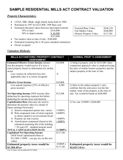


© Copyright 2026