
interdepartmental site plan review committee
Planning Board Member Information ______________________________________________________________________________ DATES TO REMEMBER: March 12, 2015 - 4:30 P.M. Public Hearing March 23, 2015 - 2:15 P.M. Sign Check March 26, 2015 - 4:30 P.M. Work Session April 9, 2015 - 4:30 P.M. Public Hearing April 23, 2015 - 4:30 P.M. Work Session April 27, 2015 - 1:15 P.M. Sign Check MEETING CONTACT INFORMATION: 100 E. First Street- (336) 747-7069 INFORMATION EMAIL: mailto:[email protected] Rules and Procedures • Persons supporting the zoning request have up to 12 minutes total. • Persons opposing the rezoning request have up to 12 minutes total. • There are no rebuttals. • During the work session, no one is permitted to speak unless the Planning Board asks them a specific question. • For general use zoning requests, the Planning Board must consider the full range of uses allowed in the zoning district being requested. The petitioner may not refer to a specific intended use of the property. • For special use district zoning requests, the petitioner must identify the intended use or uses of the site and give specific details on how the site will be developed. • Most requests listed under agenda item “B” require final action by an elected body (the City Council for cases within the City of Winston-Salem zoning jurisdiction and the Board of Commissioners for cases within Forsyth County zoning jurisdiction). As such, votes taken by the Planning Board concerning these items are recommendations which are considered by the elected bodies during their review of the requests. Please Turn Off All Cell Phones and Two-Way Communication Devices. This agenda is available in alternative media forms for people with disabilities. Individuals with disabilities who require assistance or special arrangements to participate in programs and activities of the Planning Department are encouraged to contact the Department at least 72 hours in advance so that proper accommodations can be arranged. For information, call 336-747-7069 (727-8319 TTY). AGENDA CITY-COUNTY PLANNING BOARD MARCH 12, 2015 4:30 P.M. FIFTH FLOOR BRYCE STUART MUNICIPAL BUILDING CALL TO ORDER PLEDGE OF ALLEGIANCE A. ACTION ON MINUTES • February 12, 2015 Public Hearing • February 23, 2015 Sign Check B. PUBLIC HEARING ITEMS 1. Zoning petition of Rural Hall, NC, FD, LLC from RS9 to LB-S (Retail Store): property is located on the southeast corner of Bethania-Rural Hall Road and Angus Street (Zoning Docket F-1550). CONTINUANCE HISTORY: February 12, 2015 to March 12, 2015 a. b. 2. Zoning petition of Brookberry Farm, LLC from RS9 and MU-S to MU-S (Residential Building, Single Family; and Planned Residential Development) and Site Plan Amendment: property is located at the southern terminus of Summer Hill Lane, west of Meadowlark Drive (Zoning Docket W-3246). a. b. c. 3. Zoning Recommendation. Site Plan Recommendation. Zoning Recommendation. Site Plan Recommendation. Site Plan Amendment Recommendation. Zoning petition of Mid Huf Ventures, Inc. from RS9 and HB to HB-L (Offices; Retail Store; and Services A): property is located on the southeast corner of South Main Street and Cassell Street (Zoning Docket W-3251). a. Zoning Recommendation. 4. Zoning petition of H Mack Charter School Consulting, LLC from LO to PB-L [Adult Day Care Home; Arts and Crafts Studio; Banking and Financial Services; Bed and Breakfast; Child Care, Drop-In; Child Day Care, Small Home; Church or Religious Institution, Neighborhood; Club or Lodge; College or University; Combined Use; Food or Drug Store; Fraternity or Sorority; Furniture and Home Furnishings Store; Government Offices, Neighborhood Organization, or Post Office; Museum or Art Gallery; Nursing Care Institution; Offices; Parking, Commercial; Police or Fire Station; Recreation Services, Indoor; Recreation Services, Outdoor; Residential Building, Duplex; Residential Building, Single Family; Residential Building, Twin Home; Restaurant (without drive-through service); Retail Store; School, Vocational or Professional; Services A; Services B; Testing and Research Lab; Theater, Indoor; Utilities; Adult Day Care Center; Child Care, Sick Children; Child Day Care Center; Life Care Community; Residential Building, Multifamily; Residential Building, Townhouse; and School, Private]: property is located on the west side of North Laura Wall Boulevard, south of Fifth Street (Zoning Docket W-3252). a. 5. Zoning petition of Art Taylor for property owned by Janice Spainhour and Joyce Bentubo from RS9 to LO-L (Veterinary Services; Offices; Residential Building, Single Family; Residential Building, Duplex; and Residential Building, Twin Home): property is located on the northwest side of Reidsville Road/U.S. 158, across from Grover Street (Zoning Docket W-3253). a. 6. Zoning Recommendation. Zoning Recommendation. Zoning petition of Anchor Associates, LLC and the Allan Anthony Trust from GBS (Car Wash) to GB-S (Arts and Crafts Studio; Banking and Financial Services; Building Contractors, General; Building Material Supply; Child Care, Drop-In; Church or Religious Institution, Community; Church or Religious Institution, Neighborhood; Club or Lodge; College or University; Convenience Store; Food or Drug Store; Fuel Dealer; Funeral Home; Furniture and Home Furnishings Store; Government Offices, Neighborhood Organization, or Post Office; Hospital or Health Center; Hotel or Motel; Institutional Vocational Training Facility; Library, Public; Motorcycle Dealer; Nursery, Lawn and Garden Supply Store, Retail; Nursing Care Institution; Offices; Park and Shuttle Lot; Parking, Commercial; Police or Fire Station; Recreation Facility, Public; Recreation Services, Indoor; Recreation Services, Outdoor; Restaurant (with drive-through service); Restaurant (without drive-through service); Retail Store; School, Vocational or Professional; Services A; Services B; Shopping Center; Shopping Center, Small; Stadium, Coliseum, or Exhibition Building; Storage Services, Retail; Testing and Research Lab; Theater, Indoor; Utilities; Veterinary Services; Adult Day Care Center; Child Care Institution; Child Care, Sick Children; Child Day Care Center; Life Care Community; Residential Building, Multifamily; Residential Building, Townhouse; School, Private; and School, Public): property is located on the southwest corner of Hanes Mall Boulevard and Stratford Road (Zoning Docket W-3254). a. b. 7. Zoning petition of Habitat for Humanity of Forsyth County, Inc. from LB-S (Services A; and Residential Building, Multifamily) and RM18 to RM18: property is located on the southwest corner of Cherry Street and Fourteenth Street (Zoning Docket W-3255). a. 8. Zoning Recommendation. Site Plan Recommendation. Zoning Recommendation. Zoning petition of Cleveland Avenue Christian Church from IP to LO-S (Funeral Home; Offices; Adult Day Care Center; Child Care, Sick Children; Child Day Care Center; Church or Religious Institution, Neighborhood; Government Offices, Neighborhood Organization, or Post Office; Hospice and Palliative Care; Museum or Art Gallery; Police or Fire Station; and Shelter for the Homeless): property is located on the south side of Tenth Street between Cleveland Avenue and Mount Zion Place (Zoning Docket W-3256). This is automatically continued to April 9, 2015 per the applicant's request and as per Planning Board's By-Laws. 9. Zoning petition of The City of Winston-Salem for property owned by others from County RS9 and MU-S to City RS9 and MU-S: property is located on the north and south sides of Heron Ridge Road, west of Meadowlark Drive (Zoning Docket W3257). a. b. 10. Zoning petition of The City of Winston-Salem for property owned by Kastania, LLC from Davidson County HC to City LB: property is located on the southwest corner of Old Salisbury Road and Friedburg Church Road (Zoning Docket W3258). a. 11. Zoning Recommendation. Site Plan Recommendation. Zoning Recommendation. A UDO Text Amendment proposed by City-County Planning and Development Services staff to amend Chapters A and B of the Unified Development Ordinances to create regulations for urban agriculture (UDO-257). a. Text Amendment Recommendation. C. PRELIMINARY SUBDIVISION APPROVAL 1. 2015004; Dipak Soin Family, LLC; east side of Meadowlark Drive, north of Ashlyn Drive; 10 lot Single Family Subdivision in RS9 zoning; City; 6.58 acres. CONTINUANCE HISTORY: February 12, 2015 to March 12, 2015 D. PLANNING BOARD REVIEWS 1. PBR 2015-03; Mt. Tabor Methodist Church; northeast side of Robinhood Road, across from Norman Road; Church, Community in IP zoning district; Section 25.21; City; 7.95 acres. 2. PBR 2015-04; BSC Holdings, Inc. for property owned by E. V. Ferrell, Jr. and Douglas Dillard; off the south side of Creekshire Way, south of Hanes Mall Boulevard; Residential Building, Multifamily in RM18 zoning; Section 2-5.64; City; 14.81 acres. E. COMMITTEE REPORTS F. STAFF REPORT G. FOR THE GOOD OF THE ORDER RESULTS OF CITY COUNCIL AND BOARD OF COMMISSIONERS HEARINGS REGARDING PLANNING MATTERS The City Council and the Board of Commissioners made the following decisions on Planning Board matters: WINSTON-SALEM CITY COUNCIL 1. Zoning Text Amendment proposed by the Community Development/Housing/General Government Committee to amend Chapter B of the Unified Development Ordinances to amend transmission tower regulations in residential zoning districts (UDO-254). APPROVED. Planning Board and staff recommended approval of the amendment. 2. Zoning petition of Robert E. Pike and White Oak Vista, LLC from LB, LB-S, and RS9 to LB-L (Arts and Crafts Studio; Food or Drug Store; Furniture and Home Furnishings Store; Restaurant (without drive-through service); Retail Store; Banking and Financial Services; Offices; Services A; Recreational Services, Indoor; Child Care, Drop-In; Church or Religious Institution, Community; Church or Religious Institution, Neighborhood; Government Offices, Neighborhood Organization, or Post Office; Limited Campus Uses; Museum or Art Gallery; and Access Easement, Private Off-Site): property is located on the north side of Country Club Road, east of Gordon Drive (Zoning Docket W-3248). APPROVED. Planning Board and staff recommended approval of the amendment including staff recommended conditions. 3. Zoning petition of LeRoy T. and Carole E. Boviall for property owned by Robert S. and Cynthia M. McNeely from LB-S to LB-L (Services A; Offices; and Retail Store): property is located on the southwest side of Reynolda Road, southeast of Yadkinville Road (Zoning Docket W-3249). APPROVED with request from Council Member to initiate new rezoning to include former uses. Planning Board and staff recommended approval of the amendment including staff recommended conditions Results March 12, 2015 -1- 4. Zoning petition of David and Ernestine Cooper from RS9 to PB-L (Residential Building, Single Family; Services A; Offices; and Retail Store): property is located on the southwest corner of Waughtown Street and Cline Street (Zoning Docket W-3250). APPROVED. Planning Board and staff recommended approval of the amendment including staff recommended conditions. FORSYTH COUNTY BOARD OF COMMISSIONERS 1. A UDO Text Amendment proposed by Friendly People That Care to amend Table B.2-6 of the Unified Development Ordinances to allow the uses “Habilitation Facility A, B, and C” in additional zoning districts (UDO-255). APPROVED. Planning Board and staff recommended approval of the amendment. Results March 12, 2015 -2- A MINUTES CITY-COUNTY PLANNING BOARD FEBRUARY 12, 2015 4:30 P.M. FIFTH FLOOR BRYCE STUART MUNICIPAL BUILDING MEMBERS PRESENT: MEMBERS ABSENT: PRESIDING: Melynda Dunigan, Arnold King, Clarence Lambe, Darryl Little, Paul Mullican, Brenda Smith, Allan Younger Tommy Hicks Arnold King CALL TO ORDER PLEDGE OF ALLEGIANCE GREAT PLACES IN NORTH CAROLINA Paul Norby presented information about an initiative by the North Carolina Chapter of the American Planning Association called “Great Places In North Carolina”. Last year our own Fourth Street in downtown Winston-Salem won the Great Main Street in North Carolina. This year the theme is Great Historic Rehabilitation and the Wake Forest Innovation Corridor is one of six finalists. Although a panel of judges selected the six finalists the winner will now be chosen through a “people’s choice voting.” Anyone can go online to greatplacesnc.org were you can vote and you are encouraged to do so. A. ACTION ON MINUTES • January 8, 2015 Public Hearing • January 26, 2015 Sign Check • January 22, 2015 Work Session MOTION: Paul Mullican moved approval of the minutes. SECOND: Clarence Lambe VOTE: FOR: Melynda Dunigan, Arnold King, Clarence Lambe, Darryl Little, Paul Mullican, Brenda Smith, Allan Younger AGAINST: None EXCUSED: None B. PUBLIC HEARING ITEMS The actual order of cases considered by the Planning Board on February 12, 2015 is determined procedurally by taking consent agenda cases first, then cases for which there was a public hearing. Accordingly, the order of cases on February 12, 2015 was: B.1., B.2., B.3., B.4., B.5., D.1., D.2., B.7., and B.8. 1. Zoning petition of Arthur L. and Diane J. Kibler from RS40 to GI: property is located on the west side of Belews Lake Drive, south of NC 65 (Zoning Docket F1549). PUBLIC HEARING FOR: None AGAINST: None WORK SESSION MOTION: Clarence Lambe moved approval of the zoning petition. SECOND: Paul Mullican VOTE: FOR: Melynda Dunigan, Arnold King, Clarence Lambe, Darryl Little, Paul Mullican, Brenda Smith, Allan Younger AGAINST: None EXCUSED: None 2. Zoning petition of Robert E. Pike and White Oak Vista, LLC from LB, LB-S, and RS9 to LB-L (Arts and Crafts Studio; Food or Drug Store; Furniture and Home Furnishings Store; Restaurant (without drive-through service); Retail Store; Banking and Financial Services; Offices; Services A; Recreational Services, Indoor; Child Care, Drop-In; Church or Religious Institution, Community; Church or Religious Institution, Neighborhood; Government Offices, Neighborhood Organization, or Post Office; Limited Campus Uses; Museum or Art Gallery; and Access Easement, Private Off-Site): property is located on the north side of Country Club Road, east of Gordon Drive (Zoning Docket W-3248). PUBLIC HEARING FOR: None AGAINST: None WORK SESSION MOTION: Clarence Lambe moved approval of the zoning petition. SECOND: Paul Mullican VOTE: FOR: Melynda Dunigan, Arnold King, Clarence Lambe, Darryl Little, Paul Mullican, Brenda Smith, Allan Younger AGAINST: None EXCUSED: None 3. Final Development Plan of Eve Jean Taylor and Francesco Parascandolo for a MUS TWO PHASE zoned site for the use of Restaurant (without drive-through service): property is located on the southeast corner of Hanes Mill Road and Brassfield Drive (Zoning Docket W-2667). PUBLIC HEARING FOR: None AGAINST: None WORK SESSION MOTION: Clarence Lambe moved approval of the zoning petition. SECOND: Paul Mullican VOTE: FOR: Melynda Dunigan, Arnold King, Clarence Lambe, Darryl Little, Paul Mullican, Brenda Smith, Allan Younger AGAINST: None EXCUSED: None 4. Zoning petition of LeRoy T. and Carole E. Boviall for property owned by Robert S. and Cynthia M. McNeely from LB-S to LB-L (Services A; Offices; and Retail Store): property is located on the southwest side of Reynolda Road, southeast of Yadkinville Road (Zoning Docket W-3249). PUBLIC HEARING FOR: None AGAINST: None WORK SESSION MOTION: Clarence Lambe moved approval of the zoning petition. SECOND: Paul Mullican VOTE: FOR: Melynda Dunigan, Arnold King, Clarence Lambe, Darryl Little, Paul Mullican, Brenda Smith, Allan Younger AGAINST: None EXCUSED: None 5. Zoning petition of David and Ernestine Cooper from RS9 to PB-L (Residential Building, Single Family; Services A; Offices; and Retail Store): property is located on the southwest corner of Waughtown Street and Cline Street (Zoning Docket W3250). PUBLIC HEARING FOR: None AGAINST: None WORK SESSION During discussion by the Planning Board the following comments were made: Melynda Dunigan: This is a very small lot with very little parking. The adjacent home is very close and there does not seem to be room for a buffer. I appreciate the intent to keep the historic property. Limited zoning seems too open-ended. Retail could be too intense for this. I would like to see a special use district request with a site plan so we could know what is being proposed. MOTION: Clarence Lambe moved approval of the zoning petition. SECOND: Paul Mullican VOTE: FOR: Arnold King, Clarence Lambe, Darryl Little, Paul Mullican, Brenda Smith, Allan Younger AGAINST: Melynda Dunigan EXCUSED: None 6. Zoning petition of Rural Hall, NC, FD, LLC from RS9 to LB-S (Retail Store): property is located on the southeast corner of Bethania-Rural Hall Road and Angus Street (Zoning Docket F-1550). This was automatically continued to March 12, 2015 per the applicant's request and as per Planning Board's By-Laws. 7. A UDO Text Amendment proposed by City-County Planning and Development Services staff to amend Chapter D of the Unified Development Ordinances to revise the regulations pertaining to Minor Subdivision Exceptions (UDO-256). PUBLIC HEARING FOR: None AGAINST: None WORK SESSION MOTION: Clarence Lambe moved approval of the zoning petition. SECOND: Paul Mullican VOTE: FOR: Melynda Dunigan, Arnold King, Clarence Lambe, Darryl Little, Paul Mullican, Brenda Smith, Allan Younger AGAINST: None EXCUSED: None 8. Public hearing on North Central Winston-Salem Area Plan Update. The plan area is bounded on the north by Reynolds Boulevard and Akron Drive; on the east by US 52; on the south by Martin Luther King Jr. Drive, Eighth Street, and the Southern Railway; and on the west by the Old Town Country Club. Kelly Bennett presented the staff report. PUBLIC HEARING FOR: Jeff MacIntosh, 129 Woodbriar Road, Winston-Salem, NC 27106 • I’m curious as to the Whitaker Park announcement and what is going to be happening there. Would we go back again and look at that some more? That could potentially have a huge impact on land use around it. Staff explained that Whitaker Park was mostly covered by the North Suburban Winston-Salem Area Plan Update. However a portion of the area is within the North Central Winston-Salem Area Plan Update boundaries. The recommendation here is for offices and industrial. Chairman King noted that as best we can tell it fits with what this plan proposes. AGAINST: None WORK SESSION During discussion by the Planning Board the following points were made: In light of the recent developments regarding two schools located within the boundaries of this area plan and on land which could be contaminated, Paul Norby said that staff has developed some additional language which could be incorporated into a couple places in the area plan if the Board wished to address the concerns regarding potentially hazardous sites. The Planning Board discussed the issue in depth. Among the points made by various Board members were: Arnold King: Each area plan covers a large section of the City/County. Beginning to single out specific brownfield sites to indicate issues which may exist will set a precedent that realistically can’t be done. It goes beyond the intent of what area plans are designed to do. Melynda Dunigan: My concern is the cumulative impact of a concentration of sites and whether there should be a public policy to remedy that. We won’t know to do that if we don’t do a wider examination. Clarence Lambe: You don’t discover the nature of the remediation requirement until you do phase one or phase two. Some brownfield sites require a less extensive clean-up while others may require millions of dollars. If you aren’t careful, you can stigmatize entire neighborhoods with a site requiring only small remediation. Brenda Smith: There are public agencies which deal with this and that information is publically available. It is inappropriate to go to that much detail within our process. Recognizing the historical uses is as much as would be appropriate to put in our planning process. There is concern that people reading the area plan might think what they see there is all there is to be considered. They need to go to the specific groups that manage these issues to get the information. The Board then decided to review the additional language staff developed for their consideration. Various opinions were expressed, and the final consensus is noted in the motion below. Board members noted their wish that the City Council be made aware that they have concern about the Hanes/Lowrance situation but many do not feel the area plans are the appropriate place to address the details of issues on specific sites. The Board supports efforts by responsible parties to identify ways to remedy this and similar situations in the future. However, most Board members feel that area plans should be limited to general references about potential contamination and the places where interested parties can obtain more information about specific sites. Ms. Dunigan noted that she would be voting against adoption of the area plan because she feels that reference to potentially contaminated sites such as the Hanes/Lowrance site should be addressed in more detail in area plans. However, she supports the rest of the plan. MOTION: Clarence Lambe moved approval of the area plan with edits and clarifications as recommended by staff and with the following changes: 1) Under the Existing Conditions section, “The Environment”, add a subsection “Contaminated Sites” with the following: Some sites in the planning area may have environmental contamination due to the presence of a hazardous substance, pollutant, or other contaminant. Contamination is often found on or near sites that were previously used for heavy industrial, dry cleaning, or fuel sales uses. Often, contamination issues only surface as properties are more closely examined as they are being developed or redeveloped. For more specific and upto-date information on contaminated sites, contact the North Carolina Department of Environment and Natural Resources (NCDENR). 2) Under the Recommendations section, “Environmental Recommendations”, subsection “General Recommendations” add the following: • Carefully evaluate potential sites for development and redevelopment that may have been affected by environmental contamination in the planning area. This would be especially appropriate for residential, institutional, and public gathering uses on sites near current and former heavy industrial operations with documented environmental hazards. 3) In addition, a sentence will be added after the “Contaminated Sites” paragraph which directs people to the agencies where the appropriate information is provided. SECOND: Allan Younger VOTE: FOR: Arnold King, Clarence Lambe, Darryl Little, Paul Mullican, Brenda Smith, Allan Younger AGAINST: Melynda Dunigan EXCUSED: None C. PRELIMINARY SUBDIVISION APPROVALS 1. 2015004; Dipak Soin Family, LLC; east side of Meadowlark Drive, north of Ashlyn Drive; 10 lot Single Family Subdivision in RS9 zoning; City; 6.58 acres. This was automatically continued to March 12, 2015 per the applicant's request and as per Planning Board's By-Laws. D. PLANNING BOARD REVIEWS 1. PBR 2015-01; Moravian Home Incorporated; northwest corner of Indiana Avenue and University Parkway; Life Care Community in RM18 zoning; Section 2-5.44; City; 14.66 acres. MOTION: Clarence Lambe moved approval of the Planning Board Review. SECOND: Paul Mullican VOTE: FOR: Melynda Dunigan, Arnold King, Clarence Lambe, Darryl Little, Paul Mullican, Brenda Smith, Allan Younger AGAINST: None EXCUSED: None 2. PBR 2015-02; Germanton Solar, LLC for property owned by JD and Louise Goldston; southeast side of Rural Hall-Germanton Road, southwest of Abshire Road; Utility in AG zoning; Section 2-5.80; County; 65.59 acres. MOTION: Clarence Lambe moved approval of the Planning Board Review. SECOND: Paul Mullican VOTE: FOR: Melynda Dunigan, Arnold King, Clarence Lambe, Darryl Little, Paul Mullican, Brenda Smith, Allan Younger AGAINST: None EXCUSED: None E. COMMITTEE REPORTS There are no committee reports. F. STAFF REPORT Paul Norby presented the staff report: For the March meeting there will be 10 zoning cases. Nine of those are new. There will also be one text amendment, the continued Preliminary Subdivision Approval, and two Planning Board Reviews. George Bryan has been appointed to the Planning Board by the City Council and is awaiting confirmation by the County Commissioners. We hope to have him on board by our March 12th meeting. Clarence Lambe has been reappointed by the County Commissioners and is awaiting confirmation by the City Council. We have a new GIS planner, Kevin Edwards. He will be introduced at your February 26th work session. We have created a Development Dashboard which will be posted on the web site on a quarterly basis. It provides a summary of various types of development across Forsyth County and indicates patterns of development. G. FOR THE GOOD OF THE ORDER MINUTES CITY-COUNTY PLANNING BOARD SIGN CHECK FEBRUARY 23, 2015 8:15 A. M. PLANNING BOARD OFFICES BRYCE STUART MUNICIPAL BUILDING Members Present: Melynda Dunigan Melynda Dunigan, met with Planning staff at the Planning Board Offices at the Bryce Stuart Municipal Building and then visited each of the sites scheduled for public hearing at the March 12, 2015 Planning Board meeting. No action taken. KING TOBACCOVILLE RURAL HALL FORSYTH COUNTY F1550 WALKERTOWN BETHANIA W3257 WINSTON-SALEM LEWISVILLE W3253 W3255 KERNERSVILLE W3256 W3246 W3252 W3254 W3251 CLEMMONS City-County Planning Board Public Hearing March 12, 2015 W3258 HIGH POINT B 1 LI-S RUNNINGBROOK LN PROPOSED ZONING: LB-S RS9 EXISTING ZONING: RS9 IA-RU R AL HA LL RD SOMMERDALE CT PETITIONER: Rural Hall, NC, FD, LLC (Family Dollar) GI-S BETH AN RS9 CLEARBROOK DR DR OKE CRO UN R D HALLMARK DR S 243' S Property included in zoning request ANGUS ST 500' mail notification radius. Property not in zoning request 198' 203' 200' GB GI FORUM PW UN IN CO DOCKET #: F1550 (Continued from 2/12/2015) NORVASA ST Printed: 2/24/2015 S WIN LEM -SA TON RT HE AS TW AR D LI HB LY RD SUPP RU RA RP L O HA RA LL TE PR D FO OP RS OS ED YT H BE CO LT WA UN Y TY SCALE: 1'' represents 400' STAFF: Roberts GMA: 3 ACRES: 1.02 NEAREST BLDG: 10' east MAP(S): 6819.02 re a Pl an Pl an Rural Hall Y DR HLE AS W WALL ST OMAR DR PETR E E FAR M L N Unincorporated G IN CR ANIA-RURAL BETH ALL RD H BIT T HAL L Unincorporated BITTIN G HALL D R Tobaccoville CANYON DR Unincorporated Rural Hall MA RIONS COUN TRY LN RUNNINGBROOK LN Tobaccoville Area Plan North Suburban Area Plan SOMMERDALE CT all lH ted ra ra Ru po or inc Un m ale -S ton ins W CLEARBROOK DR l ra rt h Ha bu ea H US 52/ Bethania-Rural ASA ST HallNORV Road BR N C A RD AURORA GLEN DR HO FF M Commercial / Industrial *n WY Mixed-Use Development PW LT BE Commercial UM NORTHSTAR DR Industrial MONTROYAL RD SKYE Institutional ABBEY LNPark / Open Space Commercial Recreation Special Land-use Condition Area JAMMIE CT SHORE R D OR 0 Feet FL 500 MIZ PAH 250 CHUR CH RD E AV N CE Mixed-use Opportunity Area Printed: 2/17/2015 500 VESTAL R D Rural Hall * Unincorporated Utilities Activity Center SUNSET DR O LD Office / Low-Intensity Commercial LY R D ST AN Office / Moderate-Density Residential FO R K RE E Manufactured Housing Park SUPP E SID RN BU Intermediate-Density WEATHEREND D RResidential C SSY Moderate-Density Residential G RA an Pl Urban Residential Office OPAL DR lan Ar aP Low-Density Residential HALLMARK DR re an rb Agriculture / Large-Lot Residential ll A Su Proposed Land Use ANGUS ST Ru No (Proposed land uses shown are generalized. See area plan for specific recommendtations.) Case F1550 BE TH AN HA IA-R U LL RD RAL Rural Hall Area Plan, 2011 CROO K RUN R E D D BALMORAL HILL RD re a CT A PINE TAG al lA BUC KHAVEN le H BANNOCKBURN RD al *r CITY-COUNTY PLANNING BOARD DRAFT STAFF REPORT PETITION INFORMATION Docket # Staff Petitioner(s) Owner(s) Subject Property Address Type of Request Proposal Continuance History Neighborhood Contact/Meeting Zoning District Purpose Statement Applicable Rezoning Consideration from Chapter B, Article VI, Section 6-2.1(R) F-1550 March 2015 F-1550 Gary Roberts, Jr. AICP Rural Hall, NC, FD, LLC Same PIN #s 6819-69-3740 (Formerly 6819-69-3635, 3755, and 4657) 949 Bethania-Rural Hall Road Special use rezoning from RS9 to LB-S The petitioner is requesting to amend the Official Zoning Maps for the subject property from RS9 (Residential, Single Family; 9,000 sf minimum lot size) to LB-S (Limited Business- special use zoning). The petitioner is requesting the following use: • Retail Store The request was continued (at the request of the petitioner) from the February 12, 2015 Planning Board meeting to the March 12 meeting. The Town of Rural Hall sponsored a drop-in session to receive public comment at the Rural Hall Town Hall on Thursday, January 22, 2015 from 6-8pm. Also, the following was included in an email received from the petitioner’s legal representative, Don Nielson, on March 3, 2015: “ Last night (Monday March 2) Joe Strickland and I had a second community meeting about case F1550 at the Rural Hall Town Hall from 5 to 6:30. We shared the revised site plan as well as drawings of the proposed building (all previously submitted to you). 17 people signed in—there could have been a few who came and didn’t sign in but I don’t know that. Discussion focused primarily on traffic and the propriety of a retail store in this location and we shared information we had from the February staff report and the Rural Hall Area Plan.” The LB District is primarily intended to accommodate moderately intense neighborhood shopping and service centers close to residential areas. The district is established to provide locations for businesses which serve nearby neighborhoods, including smaller business locations up to ten (10) acres in size in rural areas. The district is typically located near the intersection of a collector street or thoroughfare in areas which are otherwise developed with residences. Standards are designed so that this district, in some instances, may serve as a transition between residential districts and other commercial districts. This district is intended for application in GMAs 2, 3, 4, and 5. (R)(1) - Is the proposal consistent with the purpose statement(s) of the requested zoning district(s)? Yes, the request is for a retail store on a relatively small corner lot situated between a residential area and an intensely developed commercial area within the Suburban Neighborhoods GMA. 1 Location Jurisdiction Site Acreage Current Land Use Surrounding Property Zoning and Use Applicable Rezoning Consideration from Chapter B, Article VI, Section 6-2.1(R) GENERAL SITE INFORMATION Southeast corner of Bethania-Rural Hall Road and Angus Street Forsyth County ± 1.02 acres Currently a single family home is located on the property. Direction Zoning District Use North RS9 Single family homes East RS9 Single family home South GB Rite Aid West RS9 Single family homes (R)(2) - Is/are the use(s) permitted under the proposed classification/request compatible with uses permitted on other properties in the vicinity? The proposed use of Retail Store is compatible with the uses permitted on the adjacent GB zoned property and less compatible with the low density, residential uses permitted on the adjacent RS9 zoned properties. The proposed building is located within close proximity to an adjacent home to the east. The site has a gentle slope downward to the west. Physical Characteristics Public water and sewer are available to the site. Proximity to Water and Sewer The site plan depicts a stormwater management area in the southeastern Stormwater/ portion of the site. Drainage The site is not located within a water supply watershed. Watershed and Overlay Districts The site appears to possess no development constraints such as steep Analysis of slopes, floodplains, or watersheds. General Site Information SITE ACCESS AND TRANSPORTATION INFORMATION Capacity/LOS D Street Name Classification Frontage ADT Count Bethania-Rural Major 203’ 9,300 15,800 Hall Road Thoroughfare Angus Street Local Street 200’ N/A N/A The proposed site plan includes an off-site, shared access with the Proposed Access adjacent Rite Aid Pharmacy located directly south. Rite Aid has direct Point(s) access onto Bethania-Rural Hall Road. A second access is also proposed onto Angus Street. The Comprehensive Transportation Plan recommends a three lane crossPlanned Road section with wide outside lanes, curb and gutter, and sidewalks for this Improvements section of Bethania-Rural Hall Road. F-1550 March 2015 2 Trip Generation Existing/Proposed Existing Zoning: RS9 1.02 x 43,560 / 9,000 = 4 units x 9.57 (SFR Trip Rate) = 38 Trips per Day Sidewalks Transit Connectivity Proposed Zoning: LB-S 8,320 / 1,000 x 53.13 (Free-Standing Discount Store Trip Rate) = 442 Trips per Day Sidewalks are recommended along both street frontages. Transit is not available. The site will have an internal connection to the adjacent Rite Aid Pharmacy site to the south which has access onto Bethania-Rural Hall Road. A TIS is not required. Traffic Impact Study (TIS) Analysis of Site Access and Transportation Information Because the proposed retail building would not generate more than 150 vehicular trips during the peak hour, a Traffic Impact Study is not required. While the proposed use would generate approximately 442 trips per day, it appears that the three-lane, Bethania-Rural Hall Road, has excess capacity. The proposed site plan shows two points of access to the site. The first would be an off-site shared access onto Bethania-Rural Hall Road with the existing access for the adjacent Rite Aid Pharmacy to the south. The second access point would be onto Angus Street. To minimize the visual impact onto this otherwise residential portion of Angus Street, and to help calm the traffic which would use this driveway, staff recommends reducing the width of the proposed driveway which is currently proposed for 40 feet. CONFORMITY TO PLANS AND PLANNING ISSUES Growth Management Area 3 - Suburban Neighborhoods Legacy GMA Relevant Legacy Increase density at activity centers and growth corridors at planned Recommendations locations Construct additional sidewalks Rural Hall Area Plan (2011) Relevant Area Plan(s) Specific recommendation for the subject property: Area Plan Recommendations Office and low-intensity commercial land use are recommended for the subject property. Properties within the US 52/Bethania-Rural Hall Activity Center: Create a pedestrian-friendly character through the development/redevelopment of properties by ensuring buildings and streets are designed for pedestrian comfort. Locate new buildings and redevelop existing ones to be closer to the street to create an interesting and inviting public/private streetscape and locate parking to the side or rear of structures to de-emphasize vehicles. F-1550 March 2015 3 Site Located Along Growth Corridor? Site Located within Activity Center? Other Applicable Plans and Planning Issues Addressing Applicable Rezoning Consideration from Chapter B, Article VI, Section 6-2.1(R) Analysis of Conformity to Plans and Planning Issues General area plan recommendations: Protect residential areas from inappropriate residential, commercial, institutional and industrial encroachment. Concentrate commercial services in designated areas and not allow them to take the form of strip development along major roads in the Planning Area. Facilitate walking, biking, use of public transportation, and rail, with new development and redevelopment in the Planning Area. Commercial areas should be compact with limited access directly onto major thoroughfares. The site is not located along a growth corridor. The site is located within the northern portion of the US 52/BethaniaRural Hall Road activity center (see area plan recommendations above). The subject property is located within the corporate limits of the Town of Rural Hall. As noted in the attached letter dated February 2, 2015 (Attachment B) the Town does not support the proposed rezoning. The address assignment for this new building is 975 Bethania-Rural Hall Road. (R)(3) - Have changing conditions substantially affected the area in the petition? No (R)(4) - Is the requested action in conformance with Legacy? Yes The subject request for LB-S zoning would permit the construction of an 8,320 square foot retail building. The site is currently zoned RS9 and contains a single family residence. The Rural Hall Area Plan recommends office and low-intensity commercial use for the subject property which is located within the US 52/Bethania-Rural Hall Road activity center. Although from a land use standpoint the subject request is reasonably consistent with the area plan recommendation, Planning staff emphasizes that the site forms the northern edge of said activity center and it is adjacent to single family homes on three sides. These unique characteristics of the site make the design of the proposed development important, since a design which is insensitive to the adjacent residential could have a negative effect on the neighborhood. In order to achieve a more sensitive transition to the surrounding low density residential areas, Planning staff recommends several conditions. The proposed LB district allows for a thirty-five (35) foot tall sign with a maximum copy area of seventy-five (75) square feet. Planning staff recommends a maximum sign height of eight (8) feet and a maximum F-1550 March 2015 4 copy area of fifty (50) square feet. To reduce the lighting impacts on said adjacent properties and for motorists on the adjacent streets, staff recommends a lighting condition. Additional recommended conditions include: the provision of sidewalks along both street frontages; and providing an opaque fence along the eastern property line. The developer has agreed to these recommended conditions. Staff also recommends the dumpster be relocated from the highly visible frontage along Angus Street, to the south side of the building, and that the driveway width of the proposed entrance onto Angus Street be reduced as noted previously. The petitioner has volunteered the attached building elevations. RELEVANT ZONING HISTORIES There are no recent zoning histories in the vicinity of the subject property. SITE PLAN COMPLIANCE WITH UDO REQUIREMENTS Building Square Footage Placement on Site Square Footage 8,320 Southeastern corner Parking Required Proposed Layout 28 spaces 28 spaces In front of the building Building Height Maximum Proposed 40’ 35’ Impervious Maximum Proposed Coverage 75% 62% UDO Sections Chapter B, Article II, Section 2-1.3 (G) Limited Business District Relevant to Subject Request (A) Legacy policies: Yes Complies with Chapter B, (B) Environmental Ord. N/A Article VII, (C) Subdivision Regulations N/A Section 7-5.3 The proposed site plan is for a 8,320 square foot retail store and Analysis of Site Plan Compliance associated parking. A stormwater management area is located in the northeastern portion of the site and a 15’ Type III bufferyard is shown with UDO along the eastern property line adjacent to RS9 zoned property. Requirements CONCLUSIONS TO ASSIST WITH RECOMMENDATION Positive Aspects of Proposal Negative Aspects of Proposal The request is consistent with the Rural The request extends commercial zoning deeper Hall Area Plan in regard to the proposed into a single family residential area. retail store use. The site is adjacent to GB zoning to the The proposed new retail store will increase traffic south. in the area. The Town of Rural Hall does not support the request. SITE-SPECIFIC RECOMMENDED CONDITIONS OF APPROVAL The following proposed conditions are from interdepartmental review comments and are proposed in order to meet codes or established standards, or to reduce negative off-site impacts. • PRIOR TO THE ISSUANCE OF BUILDING PERMITS: a. Developer shall obtain a Land Disturbing Permit. F-1550 March 2015 5 b. An engineered lighting plan shall be submitted to the Inspections Division for the proposed lighting demonstrating the use of full-cut off fixtures, light height of 25' or less and no more than 0.5 foot-candle along all property lines. c. Developer shall dedicate 40’ of right-of-way from the centerline of Bethania-Rural Hall Road. d. The proposed building plans shall be in substantial conformance with the submitted elevations as shown on “Exhibit A” as verified by Planning staff. • PRIOR TO THE ISSUANCE OF OCCUPANCY PERMITS: a. Lighting shall be installed per approved lighting plan and certified by an engineer. b. Developer shall install sidewalks (minimum five feet (5’) in width) along both street frontages. c. Developer shall install an opaque fence along the entire length of the eastern property line as shown on the site plan. d. Building shall be constructed in substantial conformance with the approved building elevations approved by Planning staff. • OTHER REQUIREMENTS: a. Freestanding signage shall be limited to one sign with a maximum height of eight (8) feet and a maximum copy area of fifty (50) square feet. STAFF RECOMMENDATION: Approval NOTE: These are staff comments only; final recommendations on projects are made by the City-County Planning Board, with final decisions being made by the appropriate Elected Body, who may approve, deny, table or request modification for any project. THE APPLICANT OR REPRESENTATIVE IS STRONGLY ENCOURAGED TO ATTEND THE PUBLIC HEARINGS WHERE THE CASE WILL BE CONSIDERED BY THE PLANNING BOARD AND THE ELECTED BODY. F-1550 March 2015 6 F-1550 ATTACHMENT A EXISTING RS9 USES ALLOWED Forsyth County Jurisdiction Only USES ALLOWED WITH A PERMIT FROM THE ZONING OFFICER (Z) Adult Day Care Home Agricultural Production, Crops Agricultural Production, Livestock Child Day Care, Small Home Church or Religious Institution, Neighborhood Family Group Home A Police or Fire Station Recreation Facility, Public Residential Building, Single Family Swimming Pool, Private Transmission Tower (see UDO) USES ALLOWED WITH REVIEW BY THE PLANNING BOARD (P) Church or Religious Institution, Community Golf Course Library, Public Limited Campus Uses Planned Residential Development School, Private School, Public Utilities USES ALLOWED WITH SPECIAL USE PERMIT FROM ZONING BOARD OF ADJUSTMENT (A) Bed and Breakfast Child Day Care, Large Home Habilitation Facility A Landfill, Land Clearing/Inert Debris, 2 acres or less Manufactured Home, Class A Park and Shuttle Lot Transmission Tower USES ALLOWED WITH SPECIAL USE PERMIT FROM ELECTED BODY (E) Access Easement, Private Off-Site Parking, Off-Site, for Multifamily or Institutional Uses Uses Allowed in RS9 Revised 4/28/2014 INTERDEPARTMENTAL SITE PLAN REVIEW COMMITTEE Project Case Number: F-1550 PRELIMINARY COMMENTS AND/OR RECOMMENDED CONDITIONS Note: City-County Planning staff is responsible for coordinating the Interdepartmental Review of Special Use Rezoning Requests; please contact the appropriate Department at the phone # indicated below if you have any questions about the comments or recommendations lists. Further, please note that additional information may be forthcoming from Departments that indicate "See Emailed Comments" or other similar phrase. A list of recommended conditions from this Interdepartmental Review will be sent to you via e-mail generally by the end of the business day on Friday the week prior to the Planning Board Public Hearing. PROJECT CASE NUMBER: F-1550 PROJECT TITLE: Family Dollar DATE: January 28, 2015 PROJECT DESCRIPTION: Southeast corner of Bethania-Road and Angus Street NCDOT- Phone # - 336.747.7900 Email: [email protected] No Comments WSDOT- Phone # - 336.747.6872 Email: [email protected] Bethania Rural Hall Road is a major thoroughfare with a future cross-section of 3-B with sidewalk and bike accommodations. Dedicate right-of-way 40’ from center. Why is the drive aisle 40’? Connection to shared drive should not have a left turn movement as this would flow against the Rite Aid drive thru circulation. Dumpster angle will be difficult to service. City Engineer- Phone # - 336.747.6846 Email: [email protected] 1. No comments Inspections (Zoning)- Phone # - 336.747.7455 Email: [email protected] -Need copy of recorded shared access easement or reference book and page number -Show interior Motor Vehicle Surface Area (MVSA) plantings -Change Angus St on left side of plan to Hallmark Drive -Label dumpster enclosure height/type -Air handling machinery/condenser must be 50’ from residentially zone property -Remove density calculations -Show turning template for dumper and loading space Erosion Control - Phone # - 336.747.7453 Email: [email protected] An Environmental Grading and Erosion Control Permit will be required if more than 10,000 square feet is to be disturbed during any potential construction. An Erosion and Sedimentation Control plan must be submitted and approved before the permit can be issued. Please submit this plan at least 30 days prior to the intended start date of construction. Stormwater Division- Phone # - 336.747.6961 Email: [email protected] No comment INTERDEPARTMENTAL SITE PLAN REVIEW COMMITTEE Project Case Number: F-1550 Fire (County)- Phone # - 336.703-2550 Email: [email protected] No comments needed at this time based from the site plan provided. Utilities- Phone # - 336.747.7309 Email: [email protected] Any existing water and/or sewer connections will require evaluation for compliance with backflow preventer requirements, connection serviceability, and/or termination at the main. Sanitation- Phone # - 336.748.3080 Email: [email protected] No comments Planning- Phone # - 336.747.7043/747.7068 Email: [email protected] Staff recommends a sign condition of 8’ in height/50sf of copy area; staff recommends sidewalk on BRH Road and Angus; recommend reducing the driveway width onto Angus; can the dumpster be moved to the south side of the building? Recommend opaque fence along boundary with residential zoning; recommend a lighting condition. Street Names/Addresses -336.747.7048 Email: [email protected] The address assignment for this new building is 975 Bethania-Rural Hall Rd. RD RIDGE TO NWE S A L ST EM FO WA ZO RS RD NIN YT G H CO UN TY ZO NIN G NS R ID G E WI BROO KBER RY L LN PA RK L HI LN LN FR ES H 0 23 ' 118' FARM 293' EL FI MU-S EXISTING ZONING: RS9 and MU-S ER GA RD EN ASHL YN DR RD PETITIONER: Brookberry Farm LLC (Brookberry Farms Phase V) MEA DOW LA R KD R RD PROPOSED ZONING: MU-S and Site Plan Amendment M IE R AL ND O SP R EY FE RN HI LL R D HER ON LN RID G ER D DOCKET #: W3246 M SU WI BE RR YH IL L BR OO KB ER RY FA RM CR Y OSPRE 535 ' N 567' DL 190 ' ' 43 644' 330' 208 ' 73' 60' 150' ' 77 ' 160 S 300' 78' 40 ' 13 6 ' ' 43 TOM AHA WK CRE EK ' WES T WARD Property included in zoning request FORSYTH COUNTY ZONING 5 68 616 ' DS 500' mail notification radius. Property not in zoning request RS9 W NG NI HUNTERS KNOLL RD ZO FOX GATE CR TY N DL W IN SE RO BRIDGEGATE DR MEADOWLARK GLEN LN ROO K D UN NG NI CO WOODSPRING DR EB PA IG TH Printed: 2/24/2015 BROOKDALE RIDGE DR DR UN YR BR ASH ZO EM AL D -S AR ON W ST T ES SY PARK LN WALLRID G E DR IN W R FO UT WALN R SCALE: 1'' represents 600' STAFF: King GMA: 3 ACRES: 25.12 NEAREST BLDG: 10' east MAP(S): 5896.03, 5896.04 C P DY MAPLE L N S HA Y RE N E DS OL K E CR FR FIE ES LD D BR Case W3246 RE EK MU DD OW LA ER B R O OK B D R M FA R MEA D RY R ID LE CT SPU YC RK D R HE RID R H N L West Suburban Area Plan, 2012 BEVLON CT JANSU LN W IN D BE AL IE R LN RR YH IL L LN CR ASHL YN D R *j (Proposed land uses shown are generalized. See area plan for specific recommendtations.) POPLAR GROVE RD RY B ROO KBER R FA R M C SUM HILL MER LN N O ER G Proposed Land Use H I LLY CR E EK LN GN WO O Printed: 2/17/2015 AR DR L D 0 Feet 500 BE AU C RD HA M P HUNDLEY RD DARWOOD ESTATE LN RL CT E AF MEADOWLAR K GLEN LN DECK E HUNTERS KNOLL RD BRIDGEGATE DR R KD OO 250 OK EK CRE 500 BRO VER CT SIL REYNOL DS Special Land Use Condition Area WOODSPRING D R PAIG E B R lem Sa ed t nra to ins orpo W inc Un * T WALNU N PARK L WIND R O SE AL OWER RD FL D IN W R WA LLRID G E D CR F OX GAT E FO X GAT E AL Industrial Institutional Moderate-Density Residential / Institutional Park Commercial Recreation Utilities Activity Centers LN UT TN N ES CH ILL L H G PA ARD RK E LN N Low-Density Residential Urban Residential Moderate-Density Residential Intermediate-Density Residential High-Density Residential Manufactured Housing Park Office / High-Density Residential Office Office / Low-Intensity Commercial Commercial Mixed-Use Development Intermediate-Density Residential / Industrial W W IL D O OD G EY OSPR E RD RIDG DO LD S CR EEK TIMOTHY LN O REYN Y R TU LN EN S C AK O Northern B eltway (W HTON AS LACE CR alem Winston-S orat ed Unincorp est) TURY EN KS CT A O AS H R U BRY N DR CITY-COUNTY PLANNING BOARD DRAFT STAFF REPORT PETITION INFORMATION Docket # Staff Petitioner(s) Owner(s) Subject Property Address Type of Request Proposal W-3246 Aaron King Brookberry Farm, LLC Same PIN#s 5896-50-4386, 5896-60-1534, 5896-61-2054, and 5896-61-3322 No existing addresses for the subject property Special use rezoning and site plan amendment The petitioner is requesting a site plan amendment to reconfigure the lotting pattern on the existing MU-S zoned land and to amend the Official Zoning Maps for the subject property from RS9 (Residential Single Family; 9,000sf lot size) to MU-S (Mixed Use – Special use zoning). The petitioner is requesting the following uses: Residential Building, Single Family; and Planned Residential Development Neighborhood Contact/Meeting Zoning District Purpose Statement Applicable Rezoning Consideration from Chapter B, Article VI, Section 6-2.1(R) Location Jurisdiction Ward(s) Site Acreage Current Land Use Surrounding W-3246 March 2015 NOTE: General, special use limited, and special use district zoning were discussed with the petitioner(s) who decided to pursue the rezoning as presented. The petitioner has reached out to the residents of Brookberry Farm and the adjacent property owners. See attached documents for additional details. The MU-S District is intended to accommodate a comprehensively planned, pedestrian oriented mix of three (3) or more distinct land uses. This district has applications in a broad range of urban to suburban locations. The size and intensity of MU-S developments may vary based on their physical context and location. The MU-S District provides greater development flexibility in exchange for certain planning and design considerations. (R)(1) - Is the proposal consistent with the purpose statement(s) of the requested zoning district(s)? Yes, the site is partially zoned MU-S and is part of the larger Brookberry Farm development. GENERAL SITE INFORMATION Southern terminus of Summer Hill Lane, west of Meadowlark Drive City of Winston-Salem West ± 25.12 acres Undeveloped land Direction Zoning District 1 Use Property Zoning and Use Applicable Rezoning Consideration from Chapter B, Article VI, Section 6-2.1(R) Physical Characteristics Proximity to Water and Sewer Stormwater/ Drainage Watershed and Overlay Districts Analysis of General Site Information North MU-S Single family homes East RS9 Single family homes South RS9 Single family homes West MU-S Single family homes (R)(2) - Is/are the use(s) permitted under the proposed classification/request compatible with uses permitted on other properties in the vicinity? Yes, the proposed uses are residential in nature and would be consistent with the surrounding development pattern. The site contains a varying topography with a small creek located on the western edge of the site. The site has access to public water and sewer. A stormwater study will be required. The site is not located within a water supply watershed. The subject property contains 25.12 acres and is located along the eastern edge of the Brookberry Farm development. The proposed site plan depicts a continuation of the single family development in this area. The site appears suitable for the proposed improvements. SITE ACCESS AND TRANSPORTATION INFORMATION Capacity/LOS D Street Name Classification Frontage ADT Count Summer Hill Lane Local Street 50’ NA NA The site would have one access point onto the existing stub street of Proposed Access Summer Hill Lane. The site also provides a stub connection to the south Point(s) that could lead to a future connection with Wallridge Drive. In November of 2014, Winston-Salem voters approved a bond package to Planned Road fund numerous projects throughout the City. One of those projects is to Improvements widen Meadowlark Drive to a three lane section with pedestrian and bicycle facilities. The City Engineering Department is currently in the process of hiring a Transportation consultant to design this widening project. The tentative timeline has construction starting in the summer of 2016. Trip Generation - Existing Zoning: RS9 Portion Existing/Proposed 14.30 acres @ 9,000sf lots = 69 lots x 9.57 (SFR Trip Rate) = 660 Trips per day Sidewalks Transit Connectivity W-3246 March 2015 Proposed Zoning: Total Site 39 lots x 9.57 = 373 Trips per day Sidewalks are required on one side of the proposed streets. No routes available in this area. The proposed site plan has a connectivity index of 1.5 which exceeds the minimum UDO requirement of 1.2 2 Traffic Impact Study (TIS) Analysis of Site Access and Transportation Information No TIS required for this request. The proposed site plan indicates that the 39 lots in this portion of the Brookberry Farm development would gain access via an extension of Summer Hill Lane. The site plan also includes a stub street to the south that lines up with Wallridge Drive. Overall, this portion of the site has good connectivity and would appear to produce nearly 300 less trips per day than what could be developed under existing zoning conditions. CONFORMITY TO PLANS AND PLANNING ISSUES GMA 3 (Suburban Neighborhoods) Legacy GMA Relevant Legacy The mix, type, density and design of development should facilitate Recommendations walking, bicycling, and the use of transit, where available. Neighborhoods should be protected from inappropriate residential, commercial, industrial, and institutional encroachment. Clustering of residential development is recommended for large undeveloped parcels identified for residential use to protect natural features, natural vegetation, and historic resources and open space. West Suburban Area Plan (2012) Relevant Area Plan(s) The West Suburban Area Plan (2012) identified the area that includes the Area Plan Recommendations subject property as having potential to be a mixed-use area for singlefamily, multifamily, office, and commercial uses. The subject property is located within a Special Land Use Area (SLUCA) of varied uses between the Robinhood Village Community Activity Center to the north and the Country Club Road/ Shallowford Road Metro Activity Center to the south. Low-density residential is recommended for this central portion of the SLUCA. The site plan of this new phase of the development is provided, as required of the SLUCA in the area plan. The site plan is consistent with the area plan’s land use recommendations. No Site Located Along Growth Corridor? No Site Located within Activity Center? Applicable (R)(3) - Have changing conditions substantially affected the area in Rezoning the petition? Consideration No from Chapter B, (R)(4) - Is the requested action in conformance with Legacy? Article VI, Yes Section 6-2.1(R) The subject request includes 25.12 acres zoned both RS9 and MU-S. The Analysis of MU-S portion of the site was approved and included in the original Conformity to Brookberry Farm rezoning in 2003. The site plan at that time showed the Plans and MU-S portion of this request as open space. The subject request would Planning Issues combine the 14.30 acres of RS9 zoned land with the existing MU-S W-3246 March 2015 3 portion of Brookberry to create 39 single family residential lots. The request continues the same general development pattern that is seen in the adjacent portion of Brookberry. Staff is supportive of this rezoning and site plan amendment request. RELEVANT ZONING HISTORIES Case Request Decision & Direction Acreage Recommendation Date from Site Staff CCPB F-1392 RS9 & RS9-S Approved Includes 795 Approval Approval to MU-S 11/10/03 portion of the site SITE PLAN COMPLIANCE WITH UDO REQUIREMENTS 39 single family lots at an overall density of 1.55 dwelling units per acre Units (by type) and Density UDO Sections Section 2-1.5 (C) MU-S District Relevant to Subject Request (A) Legacy policies: Yes Complies with Chapter B, (B) Environmental Ord. Yes Article VII, (C) Subdivision Regulations Yes Section 7-5.3 The proposed site plan depicts a subdivision layout with lots ranging in Analysis of Site Plan Compliance size from around 10,000sf to 55,000sf. The site plan meets UDO requirements. with UDO Requirements CONCLUSIONS TO ASSIST WITH RECOMMENDATION Positive Aspects of Proposal Negative Aspects of Proposal The site is adjacent to existing MU-S The request would remove some common open zoning. space shown on the original master plan. The request appears to generate less traffic than what could be developed under existing zoning. The request is consistent with the development pattern within the existing portion of Brookberry Farm. Even with the loss of some open space associated with this request, there is still a substantial amount located within the existing Brookberry Farm development. The request is consistent with the recommendations of Legacy and the West Suburban Area Plan. SITE-SPECIFIC RECOMMENDED CONDITIONS OF APPROVAL The following proposed conditions are from interdepartmental review comments and are proposed in order to meet codes or established standards, or to reduce negative off-site impacts. • PRIOR TO ISSUANCE OF GRADING PERMITS: a. Developer shall have a stormwater management study submitted for review by the W-3246 March 2015 4 Public Works Department of the City of Winston-Salem. If required, an engineered stormwater management plan shall be submitted and approved by the Public Works Department. Plan may include the establishment of a Homeowners Association and a funded escrow account for maintenance and repair of stormwater controls. Relocation or installation of any stormwater treatment device into any buffer areas, vegetation designated to remain, or close proximity to adjacent residentially zoned land shall require a Staff Change approval at minimum, and may require a Site Plan Amendment. b. Existing trees to remain shall be cordoned off as shown on the site plan. c. No trees shall be cut prior to erosion control devices being installed and approved. Limits of creek disturbance shall not exceed 150 linear feet. If disturbance exceeds 150 linear feet, a state water quality permit will be required. • PRIOR TO ISSUANCE OF BUILDING PERMITS: a. A maximum of ten percent (10%) of the residential units shall have garages which open toward the front yard street. No more than half of those may protrude in front of the front façade of the unit. • OTHER REQUIREMENTS: a. The subject property shall be considered part of Land Bay I as shown on the original master plan (F-1392). STAFF RECOMMENDATION: Approval NOTE: These are staff comments only; final recommendations on projects are made by the City-County Planning Board, with final decisions being made by the appropriate Elected Body, who may approve, deny, table or request modification for any project. THE APPLICANT OR REPRESENTATIVE IS STRONGLY ENCOURAGED TO ATTEND THE PUBLIC HEARINGS WHERE THE CASE WILL BE CONSIDERED BY THE PLANNING BOARD AND THE ELECTED BODY. W-3246 March 2015 5 W-3246 ATTACHMENT A EXISTING RS9 USES ALLOWED Winston-Salem Jurisdiction Only USES ALLOWED WITH A PERMIT FROM THE ZONING OFFICER (Z) Adult Day Care Home Child Day Care, Small Home Church or Religious Institution, Neighborhood Family Group Home A Police or Fire Station Recreation Facility, Public Residential Building, Single Family Swimming Pool, Private USES ALLOWED WITH REVIEW BY THE PLANNING BOARD (P) Church or Religious Institution, Community Golf Course Library, Public Limited Campus Uses Planned Residential Development School, Private School, Public Utilities USES ALLOWED WITH SPECIAL USE PERMIT FROM ZONING BOARD OF ADJUSTMENT (A) Bed and Breakfast Child Day Care, Large Home Habilitation Facility A Landfill, Land Clearing/Inert Debris Manufactured Home, Class A Park and Shuttle Lot USES ALLOWED WITH SPECIAL USE PERMIT FROM ELECTED BODY (E) Access Easement, Private Off-Site Parking, Off-Site, for Multifamily or Institutional Uses Transmission Tower Uses Allowed in RS9 Revised 4/28/2014 INTERDEPARTMENTAL SITE PLAN REVIEW COMMITTEE Project Case Number: W-3246 PRELIMINARY COMMENTS AND/OR RECOMMENDED CONDITIONS Note: City-County Planning staff is responsible for coordinating the Interdepartmental Review of Special Use Rezoning Requests; please contact the appropriate Department at the phone # indicated below if you have any questions about the comments or recommendations lists. Further, please note that additional information may be forthcoming from Departments that indicate "See Emailed Comments" or other similar phrase. A list of recommended conditions from this Interdepartmental Review will be sent to you via e-mail generally by the end of the business day on Friday the week prior to the Planning Board Public Hearing. PROJECT CASE NUMBER: W-3246 PROJECT TITLE: Brookberry Farms Phase V DATE: February 25, 2015 PROJECT DESCRIPTION: Southern terminus of Summer Hill Lane, west of Meadowlark Drive NCDOT- Phone # - 336.747.7900 Email: [email protected] No comments WSDOT- Phone # - 336.747.6872 Email: [email protected] Sidewalk around the cul-de-sac. How are lots affected if property to the west is acquired? Show how the connection between Summer Hill Way and Wallridge Drive can be made with the existing topography. City Engineer- Phone # - 336.747.6846 Email: [email protected] 1. Roadway design to be approved by City Engineering. 2. Sidewalk shall extend to the back of the cul-de-sac. Inspections (Zoning)- Phone # - 336.747.7455 Email: [email protected] Show and label tree protection fencing and provide a detail Remove setback lines, density calculations, and lot requirements Include connectivity ratio Erosion Control - Phone # - 336.747.7453 Email: [email protected] An Environmental Grading and Erosion Control Permit will be required if more than 10,000 square feet is to be disturbed during any potential construction. An Erosion and Sedimentation Control plan must be submitted and approved before the permit can be issued. Please submit this plan at least 30 days prior to the intended start date of construction. Stormwater Division- Phone # - 336.747.6961 Email: [email protected] Stormwater Study Required Fire (City)- Phone # - 336. 734.1290 Email: [email protected] Hydrants are required within 700’ measure the way in which the Fire Apparatus Travels. INTERDEPARTMENTAL SITE PLAN REVIEW COMMITTEE Project Case Number: W-3246 Utilities- Phone # - 336.747.7309 Email: [email protected] Submit water and sewer extension plans to Utilities Plan Review for permitting and approval Sanitation- Phone # - 336.748.3080 Email: [email protected] Planning- Phone # - 336.747.7043/747.7068 Email: [email protected] Include connectivity ratio on site plan. Street Names/Addresses -336.747.7048 Email: [email protected] No addressing or street naming concerns. 3 DOCKET #: W3251 RM12-S LB T CHAMPLAIN ST HB SM AIN ST I M HE STOCKTON ST KONNOAK DR ST ' L 4 31 ' Printed: 2/24/2015 SOUTHEAST WARD RS9 Property included in zoning request L SE HB S YS WA G N T 500' mail notification radius. Property not in zoning request LI SOUTH WARD ANDERSON DR HAVERHILL ST PETITIONER: Mid Huf Ventures Inc. ' 2 25 SUNDOWN ST EXISTING ZONING: RS9 and HB S CA S 4 39 250' LUTHER ST EMERSON ST LOMOND ST S ON KT OC ST ST LB PATRIA ST S RD WA ED BARBER ST RMU-S WEISNER ST PROPOSED ZONING: HB-L RS9 T BORG RD ST ION UN S GH LEI OD WO RS9 SCALE: 1'' represents 400' STAFF: Roberts GMA: 2 ACRES: 2.13 NEAREST BLDG: 7' southwest MAP(S): 6834.03 NTRA L STRICKLAND AV PALMER LN D UTICA ST N O M M C LE ER ILL SV MINEOLA ST O TH ROCK ST E POTOMAC ST 500 E RHYN E AV R L ROSEMONT AV DP ELMWOOD DR E HARSON ST HARMON RD W RHYNE AV pages 42 - 46) Special Land Use Condition Areas (see text page 47) STOCKTON ST RENON Utilities Activity Center FOXWOO (see text and maps CASSELL ST OLD N RD GTO Industrial W HARSON ST BARNEY AV LEXIN Mixed-Use (see text page 42) RD KONNOAK DR MER RELL DR Office/Low-Intensity Commercial (see text page 41) Commercial Printed: 2/20/2015 DACIA N ST ra lA re Ar a Pl ea an Pl an Ce nt th DR Case W3251 ST AR LIG HT OOD CT W Office BRI C K Office/Moderate-Density Residential (see text page 41) 0 ut So u WAY S T I NG M OFT S T CH S M AI N ST ST ANDERSON D L EL SS R LUTHER ST Commercial Recreation Feet So EMERSON ST LOMOND ST STOCKTON ST G RD BOR CA CR HE HAVERHILL ST Park/Open Space 250 as t S MAIN ST T CRAVEN ST ATLANTIC ST HS PATRIA ST TRENT ST COCKERHAM ST EIG DL PLAIN AM ST Institutional 500 DR RIGHT E WRIGHT W WST ST O WO MCLEAN AV Manufactured Housing Park * n MIDDLETON ST T SS T ST C SE WI Low-Density Residential Moderate-Density Residential up to 8 du/ac (see text page 40) Intermediate-Density Residential 8-12 du/ac (see text page 40) High-Density Residential 12+ du/ac (see text page 40) ETHEL DR re a Pla BARBER ST N MARMIO RUSSELL WAY LN Proposed Land Use rba n A STARLIGHT WO O D WEISNER ST (Proposed land uses shown are generalized. See area plan for specific recommendtations.) Subu OLD D TON R RD WA ED DR BUCHANAN ST AK South V A LE D R South Suburban Area Plan, 2011 AUR E OL ST E LEXING O NN AV BE E LEMLY ST W LEMLY ST BETH AV FLEET ST EDG EW OOD V I EW L N KO ELLER ANNE AV HARTMAN ST OO D DR EDGE W ER LY CT CL OI ST CLOISTER OAKS CR BUCHANAN CT CR UBUR BAN he H CE TH S L EM SOUT SOU CITY-COUNTY PLANNING BOARD DRAFT STAFF REPORT PETITION INFORMATION Docket # Staff Petitioner(s) Owner(s) Subject Property Address Type of Request Proposal Neighborhood Contact/Meeting Zoning District Purpose Statement Applicable Rezoning Consideration from Chapter B, Article VI, Section 6-2.1(R) Location Jurisdiction Ward(s) Site Acreage Current Land Use W-3251 March 2015 W-3251 Gary Roberts, Jr. AICP Mid Huf Ventures, Inc. Same PIN #6834-31-9704 There is no address assignment for the subject property which is undeveloped. Special use limited rezoning from RS9 and HB to HB-L The petitioner is requesting to amend the Official Zoning Maps for the subject property from RS9 (Residential, Single Family district – 9,000 sf minimum lot size) and HB (Highway Business district) to HB-L (Highway Business - special use limited zoning). The petitioner is requesting the following uses: • Offices; Retail Store; and Services A NOTE: General, special use limited, and special use district zoning were discussed with the petitioner(s) who decided to pursue the rezoning as presented. In coordination with Council Member James Taylor for the Southeast Ward, a neighborhood meeting has been scheduled for Tuesday, March 24, 2015. The time and location are being finalized. The HB District is primarily intended to accommodate retail service and distributive uses. The district is established to provide locations for establishments which require high visibility and good road access, or which cater primarily to passing motorists. However, the district is not intended to encourage or accommodate strip commercial development. Developments in this district generally have substantial front setbacks. This district is intended for application in GMAs 2, 3 and 4. (R)(1) - Is the proposal consistent with the purpose statement(s) of the requested zoning district(s)? Yes, the western portion of the site is already zoned HB. The site is also adjacent to other commercially zoned properties, located within GMA 3, and has frontage on two minor thoroughfares. GENERAL SITE INFORMATION Southeast corner of South Main Street and Cassell Street City of Winston-Salem Southeast ± 2.13 acres The site is currently undeveloped. 1 Surrounding Property Zoning and Use Applicable Rezoning Consideration from Chapter B, Article VI, Section 6-2.1(R) Physical Characteristics Proximity to Water and Sewer Stormwater/ Drainage Watershed and Overlay Districts Analysis of General Site Information Direction North Zoning District LB & RS9 Use Unoccupied commercial building and a single family home East RS9 Single family homes South RS9 Single family homes West HB Dixon Animal Hospital (R)(2) - Is/are the use(s) permitted under the proposed classification/request compatible with uses permitted on other properties in the vicinity? The three requested uses within the proposed HB-L district are compatible with the uses permitted on the adjacent HB and LB zoned properties. These uses are potentially less compatible with the low density residential uses permitted on the adjacent RS9 zoned properties. The partially wooded site has a gentle to steep slope downward toward a stream that traverses the center of the site. Public water and sewer are available to the site. A public sewer line runs generally parallel with the above mentioned stream through the site. No known issues. The site is not located within a water supply watershed. The entire depth of the site is traversed by a small stream and a sanitary sewer line. There is a steep slope along either side of said stream. The southwestern portion of the lot has been cleared and appears to be readily suitable for development. Staff notes that as per the water quality section of the Winston-Salem Stormwater Management Ordinance, if more than one acre of the site is disturbed in preparation for development, a 30 foot stream buffer is required on each side of said stream as measured from the top of the bank. SITE ACCESS AND TRANSPORTATION INFORMATION Capacity/LOS D Street Name Classification Frontage ADT Count Main Street Minor 250’ 8,400 13,800 Thoroughfare Cassell Street Minor 394’ 3,400 13,800 Thoroughfare Because this is a special use limited request with no site plan, the exact Proposed Access location of access points is unknown. The site is currently accessed from Point(s) Main Street. The Comprehensive Transportation Plan recommends a two-lane cross Planned Road section for Main Street with bike lanes and sidewalks. Improvements Trip Generation - No trip generation is available for the existing general use or the proposed Existing/Proposed special use limited zoning districts which have no site plan. Sidewalks are located along Cassell Street. The construction of any Sidewalks buildings on this site will likely require the installation of sidewalk along the frontage of Main Street. W-3251 March 2015 2 Route 14 runs along Main Street. The site has frontage along two minor thoroughfares; however, the current driveway entrance into the site is from Main Street. The area is served by transit and sidewalks. Staff does not foresee any transportation related issues associated with this request. CONFORMITY TO PLANS AND PLANNING ISSUES Growth Management Area 2 - Urban Neighborhoods Legacy GMA Relevant Legacy Increase quality infill development in the serviceable land area. Recommendations Neighborhood-serving retail and community services should be encouraged near where people live and work. Promote a system of vegetative buffers along streams. South Suburban Area Plan (2011) Relevant Area Plan(s) Area Plan The recommended land use for the subject property is commercial. Recommendations New commercial opportunities and the improvement of existing commercial areas should blend with existing development and not infringe on nearby neighborhoods. The reuse of vacant buildings and the redevelopment of existing vacant and underutilized sites are recommended. The site is not located along a growth corridor. Site Located Along Growth Corridor? The site is not located within an activity center. Site Located within Activity Center? There are no addressing or street naming issues. Addressing Applicable (R)(3) - Have changing conditions substantially affected the area in Rezoning the petition? Consideration No from Chapter B, (R)(4) - Is the requested action in conformance with Legacy? Article VI, Yes Section 6-2.1(R) The subject property has HB zoning on the majority of the site and RS9 Analysis of zoning on the remaining portion. The South Suburban Area Plan Conformity to recommends commercial land use for the entire 2.13 acre site. The Plans and proposed HB-L district would permit only the uses of Retail Store; Planning Issues Offices; and Services A. The more impactful land uses (currently permitted on the HB zoned portion of the site) are not included in the current request. In order to minimize the potential impact to the single family homes located directly north and east of the site, the petitioner has agreed to a condition whereby no buildings could be built on the north side of the stream which runs through the site. Planning staff supports the request which is consistent with the adopted area plan, would result in a single zoning classification for the site, and significantly limits the potential land uses. Transit Analysis of Site Access and Transportation Information W-3251 March 2015 3 RELEVANT ZONING HISTORIES Case Request Decision & Direction Acreage Recommendation Date from Site Staff CCPB W-2850 RS9 & LB to Approved 300’ north 3.26 Approval Approval RMU-S 5-1-06 CONCLUSIONS TO ASSIST WITH RECOMMENDATION Positive Aspects of Proposal Negative Aspects of Proposal The request is consistent with the The request would extend commercial zoning commercial land use recommendation of deeper into a single family neighborhood. the area plan. The request does not include the more intense uses permitted within the HB district. The request would place a single zoning district on the subject property which now has dual zoning. The request is consistent with the HB purpose statement. No buildings could be built on the north side of the stream. The site is adjacent to HB and LB zoned land. SITE-SPECIFIC RECOMMENDED CONDITIONS OF APPROVAL The following proposed conditions are from interdepartmental review comments and are proposed in order to meet codes or established standards, or to reduce negative off-site impacts. • OTHER REQUIREMENTS: a. No buildings shall be constructed on the north side of the stream which traverses the subject property. STAFF RECOMMENDATION: Approval NOTE: These are staff comments only; final recommendations on projects are made by the City-County Planning Board, with final decisions being made by the appropriate Elected Body, who may approve, deny, table or request modification for any project. THE APPLICANT OR REPRESENTATIVE IS STRONGLY ENCOURAGED TO ATTEND THE PUBLIC HEARINGS WHERE THE CASE WILL BE CONSIDERED BY THE PLANNING BOARD AND THE ELECTED BODY. W-3251 March 2015 4 W-3251 ATTACHMENT A EXISTING RS9 and HB USES ALLOWED City of Winston-Salem Jurisdiction Only RS9 Uses: USES ALLOWED WITH A PERMIT FROM THE ZONING OFFICER (Z) Adult Day Care Home Child Day Care, Small Home Church or Religious Institution, Neighborhood Family Group Home A Police or Fire Station Recreation Facility, Public Residential Building, Single Family Swimming Pool, Private USES ALLOWED WITH REVIEW BY THE PLANNING BOARD (P) Church or Religious Institution, Community Golf Course Library, Public Limited Campus Uses Planned Residential Development School, Private School, Public Utilities USES ALLOWED WITH SPECIAL USE PERMIT FROM ZONING BOARD OF ADJUSTMENT (A) Bed and Breakfast Child Day Care, Large Home Habilitation Facility A Landfill, Land Clearing/Inert Debris Manufactured Home, Class A Park and Shuttle Lot USES ALLOWED WITH SPECIAL USE PERMIT FROM ELECTED BODY (E) Access Easement, Private Off-Site Parking, Off-Site, for Multifamily or Institutional Uses Transmission Tower HB Uses: USES ALLOWED WITH A PERMIT FROM THE ZONING OFFICER (Z) Academic Biomedical Research Facility Academic Medical Center Animal Shelter, Public Arts and Crafts Studio Banking and Financial Services Bed and Breakfast Boarding or Rooming House Building Contractors, General Building Materials Supply Car Wash Cemetery Child Care, Drop-In Church or Religious Institution, Community Church or Religious Institution, Neighborhood Club or Lodge College or University Convenience Store Correctional Institution Electronic Sweepstakes Operation Food or Drug Store Fuel Dealer Funeral Home Furniture and Home Furnishings Store Golf Course Government Offices, Neighborhood Organization, or Post Office Habilitation Facility A Habilitation Facility B Habilitation Facility C Hospital or Health Center Hotel or Motel Institutional Vocational Training Facility Kennel, Indoor Library, Public Motor Vehicle, Body or Paint Shop Motor Vehicle, Rental and Leasing Motor Vehicle, Repair and Maintenance Motor Vehicle, Storage Yard Motorcycle Dealer Museum or Art Gallery Nursery, Lawn and Garden Supply Store, Retail Offices Outdoor Display Retail Park and Shuttle Lot HB Uses Continued: Parking, Commercial Police or Fire Station Recreation Facility, Public Recreation Services, Indoor Recreation Services, Outdoor Recreational Vehicle Park Restaurant (with drive-through service) Restaurant (without drive-through service) Retail Store School, Vocational or Professional Services A Services B Shopping Center Shopping Center, Small Signs, Off-Premises Stadium, Coliseum, or Exhibition Building Storage and Salvage Yard Storage Services, Retail Terminal, Bus or Taxi Testing and Research Lab Theater, Drive-In Theater, Indoor Transmission Tower Utilities Veterinary Services Warehousing USES ALLOWED WITH REVIEW BY THE PLANNING BOARD (P) Adult Day Care Center Child Care, Sick Children Child Day Care Center Landfill, Construction and Demolition Landfill, Land Clearing/Inert Debris School, Private School, Public USES ALLOWED WITH SPECIAL USE PERMIT FROM ZONING BOARD OF ADJUSTMENT (A) Borrow Site Dirt Storage Helistop USES ALLOWED WITH SPECIAL USE PERMIT FROM ELECTED BODY (E) Access Easement, Private Off-Site Chris Frye From: Sent: To: Cc: Subject: [email protected] Tuesday, March 03, 2015 9:42 AM Chris Frye [email protected] Re-zoning To Whom this may concern: So...when does it end --the devaluating of our property values?? It seems when decisions are made at your level, the homeowner loses more value in their property, more safety in community, gain more negative changes in environment. First, the Clemmonsville Rd devastation of trees, and property, causing visual beauty, and natural settings with squirrels/birds and floral and yards to be replaced with concrete---and the end results have not made an improvement was not necessary and instead has increased hazards by replacing stoplight with "yield" that most often ignored and traffic has decreased making it less necessary ...and an increase in questionable foot traffic now this rezoning... We OPPOSE STRONGLY to re-zoning for the purpose of changing our neighborhood from one of residential and scenic beauty in community setting where we go to church and have playgrounds relatively safe for our children, and we can take walks, walk our pets have our children wait on school bus in a somewhat safe environment, enjoy our yards : In exchange for a busy and noisy commercial setting with traffic woes, more danger in just crossing the street, putting out trash, walking pets or riding our bikes -- hazardous, more opportunity for criminal activity, increase in noise, less safe and an invitation to decrease the quality of life we have worked for, most have retired to enjoy-- Where the word "neighborhood" had real meaning! PLEASE hear the hearts cry of citizens who are tax payers and are the substance on which clean and wholesome living is based. Businesses like this zone affords, often change and many vacate leaving ugly scars on our streets that we must pass everyday and often replaced with even less desirable establishments. VOTE NO ON W3251 Respectfully, Paul & Patricia Slaga Konnoak Drive W-S 1 Chris Frye From: Sent: To: Cc: Subject: Merle Lambeth <[email protected]> Wednesday, March 04, 2015 1:39 PM Chris Frye; James Taylor Jr; molly l carolyn h Re-Zoning Case To Whom It May Concern: Concerning the possibility of rezoning the area around the Nitty Gritty property, at the corner of Cassell Street and S. Main Street: Many of the residents in, and around, the SE Ward feel the same as I do ~ that this community is ready for a facelift! The Konnoak area and surrounding areas, such as Cassell Street, Main Street toward Clemmonsville Road, west toward Buchannan Street, then north toward Parkway Plaza Shopping Center, was a thriving residential area with some of the nicest houses in Winston‐Salem. I, personally, have lived in this general area for 64 years and have watched this once‐blue‐ribbon area suffer at the hands of poor city planning and greed of those that have no interest, other than financial gain. Do you, the planners and architects of the Winston‐Salem Planning Board, really and truly feel that adding possible rezonings to bring into a mostly‐residential area, businesses that may include alcohol, gambling, tattoo parlors, night clubs, and anything else that may "fester" and one day erupt in violence or worse is good for our area? I don't know who Mid‐Huf Ventures, Inc. are, but I dare say they wouldn't be in the Buena Vista area or some other prominent area of our city. I think it is shameless that you pick areas that have the least financial "clout" and inject it with the poison of business that only exploit for financial and personal gain. If you feel that I am not worth listening to, pretend you live beside me; and then tell me how you would feel! DO NOT REZONE for HB‐L. All of us vote, and we have good memories at election time! Edward "Max" Lambeth 2925 Trent Street / 785‐9676 Co‐Chair of Trent St. NW Group #344 /2900 Block Captain 1 Good morning Carolyn, Attached is the location map for the site you are referring to on Main Street. They are only asking for the uses of Retail Store, Services A, and Offices. Bob Middleton is the petitioner and he also agreed to a condition that no buildings be built north of the creek toward Cassell Street. Our staff report will be posted this Friday afternoon. His phone number is 345‐4761. I hope this helps, Gary From: Carolyn A. Highsmith [mailto:[email protected]] Sent: Tuesday, March 03, 2015 12:40 AM To: Gary Roberts Cc: Chris Murphy; [email protected]; James Taylor Jr; Molly Leight; Paul Norby Subject: RE: W3251 Zoning Case??? Clarification: In the Email below when I referred to Limited Business Zoning for the former Nitty Gritty site at 3003 S. Main St., I meant "Limited Business Zoning with restrictions" (since this site is already zoned as Limited Business). Thanks, Carolyn A. Highsmith President, Konnoak Hills Community Association, [email protected] Vice President, New South Community Coalition, [email protected] 336‐788‐9461; [email protected] From: [email protected] To: [email protected] CC: [email protected]; [email protected]; [email protected]; [email protected]; [email protected] Subject: W3251 Zoning Case??? Date: Tue, 3 Mar 2015 00:09:42 ‐0500 Dear Gary: I didn't think I'd be emailing you so soon again. But on my way to tonight's City Council Meeting (3/2/15), I saw a RED ZONING SIGN at the corner of Cassell St. and S. Main St in South Winston‐Salem that's popped up for Zoning Case W3251 where the Petitioner‐‐Mid‐Huff Ventures, Inc. wants to rezone this corner lot to HB‐L including a large section on Cassell St. that's RS‐9 and a section bordering S. Main St. that's HB. I'm writing to ask if you know anything about Mid‐Huff Ventures, Inc. and has this business entity given you any idea why they want to re‐zone this vacant property and what they want to build? Also, since I haven't been notified about this Zoning Case‐‐Has a neighborhood meeting been held yet? Such a meeting would need to include not only Cassell St. residents but also residents on S. Main St. and Anderson Dr., because this property is located at the beginning of the Konnoak Hills Community area at the intersection of S. Main St. and Anderson Drive. The Konnoak Hills Community Association has a major issue with this zoning case and will definitely be opposing it at the March 12th City‐County Planning Board. Why? Because any type of HB zoning is out of character for the neighborhood area after everything we've had to endure with the former Nitty Gritty establishment at 3003 S. Main St. directly across from this establishment. We need neighborhood friendly zoning that will prohibit another night club, tattoo parlor, massage parlor, strip club, etc.‐‐any such business that would sell alcohol and promote further crime. I'm also hypothesizing that the former Nitty Gritty site is not being considered because this site lost its ABC permit and has been flagged by the ABC Board as a potential problem. Therefore, the proposed site across the street without any prior history would be eligible for such an ABC permit. The Konnoak Hills Community Association had just recently met in February 2015 and discussed consulting with SE Ward Council Member James Taylor and South Ward Council Member Molly Leight about seeing if we could get the site of the former Nitty Gritty re‐zoned to a more appropriate Limited Business District or at most a Neighborhood Business District Zoning with restrictions or something comparable or even designated for Special Use Permit zoning. And, now we see we have a zoning case across the street that wants to continue this inappropriate HB zoning. This neighborhood area is not a high traffic highway since Hwy 52 cannot be accessed at Cassell St. So, any information that you can provide about this new zoning case will be appreciated. And, when your W3251 Staff Report is completed, I would so appreciate receiving a copy via Email. Sincerely yours, Carolyn A. Highsmith President, Konnoak Hills Community Association, [email protected] Vice President, New South Community Coalition, [email protected] 336‐788‐9461; [email protected] 4 DOCKET #: W3252 GO PB-S MLKO ND AV EXISTING ZONING: LO HB MLKO LO-S RMU 50' S RS7 MLKO LO RS7 N LAURA WALL BV WOODLAND AV E FOURTH ST RM18 RS7 E THIRD ST LO RM5 RM18 MLKO E FIFTH ST 50' 129' 130' PETITIONER: H Mack Charter School Consulting LLC N MARTIN LUTHER KING JR DR N CLE VELA RM12 PROPOSED ZONING: PB-L HB-S HB-S MLKO Property included in zoning request 500' mail notification radius. Property not in zoning request RS7 SCALE: 1'' represents 200' STAFF: Roberts GMA: 2 ACRES: 0.15 NEAREST BLDG: 5' south MAP(S): Printed: 2/26/2015 6835.02 Case W3247 Retail/Residential Mixed-Use PROGRESSIVE Area *a H ST Case W3252 ST N LAURA WALL BV *d VIRGINIA NEWELL LN WOODLAND AV VIRGINIA NEWELL LN MAPLE ST E EXC 250 0 500 ra nt lA Feet S CLEVELAND AV Ce 500 h ut So Vacant ST ER KING JR DR OR LSI Mixed-Use Development Industrial N Institutional RESEARCH PW S Park / Open Space R ESEAR C H PW Utility ERY Low-Density Residential Urban Residential Moderate-Density Residential Intermediate Density Residential ST re t-No rthe ast Sou Are the aP ast lan Are CR aP OM lan ART IE ST S JACKSON AV S LAURA WALL BV Proposed Land Use Changes S Eas N LAURA WALL BV GA OM E N CAMERON AV LOW E FIRS T ST DR AY Residential Opportunity Areas GR (See text page 30) C E Low Density (up to 5 du/ac) Urban (Single-Family to Quadraplex) Moderate Density (up to 8 du/ac) Intermediate Density (up to 12 du/ac) Union Station Mixed-Use Area Office Office / Low-Intensity Commercial (See text pages 40-41) Commercial Mixed Use Opportunity Areas (See text page 60) Special Land Use Condition Areas (See text page 36) Activity Center (AC) (See text page 40) REIndustrial SEAR C H P Institutional W Open Space / Park 500 250 0 Feet 500 LOW ERY S CAMERON AV Commercial (Proposed land uses shown are generalized. See area plan for specific recommendtations.) S GRAHAM AV Office LUTH RTIN Multifamily Residential *c East/Northeast Winston-Salem Area Plan, 2008 MARYLAND AV S CAMERON AV DR S GRAHAM AV RAY S MA Triplex/Quadraplex Residential N DUNLEITH AV E FIRS T ST G CE Single-Family/Duplex Residential E SECOND ST CT S JACKSON AV S CLEVELAND AV S LAURA WALL BV Existing Land Uses WHEELER ST GA OM E LAWRENCE ST East/Northeast Winston-Salem Area Plan, 2008 (Existing land uses shown are generalized. See area plan for specific recommendtations.) E THIRD ST N DUNLEITH AV N CLEVE WOODLAND AV METROPOLITAN DR E FOURTH E THIRD ST GREYHOUND CT *b E FIFTH ST UNIVERSITY CT E SECOND ST CT NEW WALKERTOWN RD N CAMERON AV E SEVEN T LOCUST AV GRAY AV GRAHAM CT Case W3252 E FIFTH ST E FOURTH ST MOUNT ZION PL WHEELER ST LAND AV NEW WALKERTOWN RD East Winston MAC E NINTH ST N GRAHAM AV ST LE FI GRAHAM CT H ST E TENTH ST N JACKSON AV GRAY AV N GRAHAM AV MOUNT ZION PL E EIGHTH ST HIGHLAND AV N JACKSON AV ST FI LE HIGHLAND AV Downtoan Plan CARL RUSSELL AV E NINTH ST Martin Luther KIng Jr Dr/ Cleaveland Ave / New Hope Ln Mixed-Use Area East-Northeast Area Plan Downtown Plan E EIGHTH ST E SEVEN T MAPLE ST E TENTH ST V TA M ON NN MARTIN LUTHER KING JR DR RESEARCH PW Y RT North Central Area Plan E CLAR East-Nort heast Area Plan North Central Area Plan HIGHLAND CT N E ELEVENTH ST BE Adopted Plan: Proposed Land Use Changes LI ST LN Adopted Plan: Existing Land UsesE ELEVENTH ST CARL RUSSELL AV Y LINDEN STN RT BE LI ST ST *e Eas t-No rthe ast Sou Are the aP ast lan CR Are OM aP ART l an IE ST a an Pl CITY-COUNTY PLANNING BOARD DRAFT STAFF REPORT PETITION INFORMATION Docket # Staff Petitioner(s) Owner(s) Subject Property Address Type of Request Proposal Neighborhood Contact/Meeting Zoning District Purpose Statement W-3252 March 2015 W-3252 Gary Roberts, AICP H Mack Charter School Consulting, LLC Same PIN #6835-67-4597 414 North Laura Wall Boulevard Special use limited rezoning from LO to PB-L The petitioner is requesting to amend the Official Zoning Maps for the subject property from LO (Limited Office district) to PB-L (Pedestrian Business – special use limited zoning). The petitioner is requesting the following uses: • Adult Day Care Home; Arts and Crafts Studio; Banking and Financial Services; Bed and Breakfast; Child Care, Drop-In; Child Day Care, Small Home; Church or Religious Institution, Neighborhood; Club or Lodge; College or University; Combined Use; Food or Drug Store; Fraternity or Sorority; Furniture and Home Furnishings Store; Government Offices, Neighborhood Organization, or Post Office; Museum or Art Gallery; Nursing Care Institution; Offices; Parking, Commercial; Police or Fire Station; Recreation Services, Indoor; Recreation Services, Outdoor; Residential Building, Duplex; Residential Building, Single Family; Residential Building, Twin Home; Restaurant (without drive-through service); Retail Store; School, Vocational or Professional; Services A; Services B; Testing and Research Lab; Theater, Indoor; Utilities; Adult Day Care Center; Child Care, Sick Children; Child Day Care Center; Life Care Community; Residential Building, Multifamily; Residential Building, Townhouse; and School, Private NOTE: General, special use limited, and special use district zoning were discussed with the petitioner(s) who decided to pursue the rezoning as presented. The application indicates that no neighborhood meeting has been held. The PB District is primarily intended to accommodate office, retail, service, institutional and high density residential uses which customarily serve community and convenience business needs of smaller communities and urban nodes in the city and county. The district is intended to encourage the development of attractive, identifiable small towns, and to accommodate the pattern of building in the business concentrations surrounding the central core of Winston-Salem, and the central core of other municipalities in the County. The district should demonstrate pedestrian oriented design through elements such as buildings pulled up to the street, on-street parking, street trees, covered arcades, awnings, storefront display windows, public/private outdoor spaces, wide 1 Applicable Rezoning Consideration from Chapter B, Article VI, Section 6-2.1(R) Location Jurisdiction Ward(s) Site Acreage Current Land Use Surrounding Property Zoning and Use Applicable Rezoning Consideration from Chapter B, Article VI, Section 6-2.1(R) Physical Characteristics Proximity to Water and Sewer Stormwater/ Drainage Watershed and Overlay Districts Analysis of General Site Information sidewalks, and building entrances facing the street. This district is intended for application in GMAs 1, 2 and 3. (R)(1) - Is the proposal consistent with the purpose statement(s) of the requested zoning district(s)? Yes, the subject property is located within GMA 2 and within an activity center which is pedestrian oriented. Sidewalks and transit are available in the area. GENERAL SITE INFORMATION West side of North Laura Wall Boulevard, south of Fifth Street City of Winston-Salem East ± .15 acre Currently, a 1,394 square foot structure is located on the subject property. The structure was originally constructed as a single family residence but was most recently used as an office. It is currently vacant. Direction Zoning District Use North LO Undeveloped property East LO-S Bank of America South LO Single family home West LO Medical office (R)(2) - Is/are the use(s) permitted under the proposed classification/request compatible with uses permitted on other properties in the vicinity? Yes, the proposed office, service, and commercial uses are generally compatible with the permitted uses on the adjacent LO-S and LO zoned properties. The developed site has a gentle slope downward toward the southwest. Public water and sewer are available to the site. No known issues. The site is not located within a water supply watershed. The site appears to possess no development constraints such as steep slopes, floodplains, or watersheds. Due to the relatively small size of the lot and the placement of the structure thereon, it does not appear to accommodate any off-street parking. SITE ACCESS AND TRANSPORTATION INFORMATION Capacity/LOS D Street Name Classification Frontage ADT Count North Laura Wall Local Street 50’ N/A N/A Boulevard Because this is a special use limited request with no site plan, the exact Proposed Access location of access points is unknown. The site is currently accessed from Point(s) North Laura Wall Boulevard. W-3252 March 2015 2 Trip Generation Existing/Proposed Sidewalks Transit Analysis of Site Access and Transportation Information No trip generation is available for the existing general use or the proposed special use limited zoning districts which have no site plan. Sidewalks are located along both sides of all the streets in the general area. Route 17 runs along Highland Avenue approximately 970’ to the west. Staff does not anticipate any transportation related issues associated with this request. The general area is characterized by an urban network of well-connected streets with sidewalks. Transit is located nearby. CONFORMITY TO PLANS AND PLANNING ISSUES Growth Management Area 2 - Urban Neighborhoods Legacy GMA Relevant Legacy Encourage quality infill development, neighborhood businesses, and Recommendations community services. Historic preservation, rehabilitation, and the reuse of existing structures should be encouraged. East-Northeast Area Plan (2008) Relevant Area Plan(s) Area Plan The East-Northeast Area Plan recommends office/low-intensity Recommendations commercial for the subject property. The reuse of vacant buildings and the redevelopment of existing vacant and underutilized sites are recommended as an alternative to rezoning land for additional commercial development. The Plan recommends the consolidation of commercial and office uses in designated activity areas, such as the East Winston #2 Activity Center where the subject property is located within. The conversion and retention of existing single-family structures to office use is recommended for those residential structures located next to commercial uses or along major thoroughfares impacted by high traffic volumes. The site is not located along a growth corridor. Site Located Along Growth Corridor? The site is located within the East Winston #2 Activity Center. Site Located within Activity Center? There are no addressing or street naming issues. Addressing Applicable (R)(3) - Have changing conditions substantially affected the area in Rezoning the petition? Consideration No from Chapter B, (R)(4) - Is the requested action in conformance with Legacy? Article VI, Yes Section 6-2.1(R) The subject request is to rezone a modest size property from LO to PB – Analysis of L. The structure on the site was originally developed as a single family Conformity to home and most recently has been used as an office. The site is adjacent to Plans and LO and LO-S zoned properties on all sides. Planning Issues The East-Northeast Area Plan identifies the site as being with the East W-3252 March 2015 3 Winston #2 Activity Center and the recommended land uses are office and low-intensity commercial. The latter category excludes auto-related uses and Convenience Stores. The petitioner has agreed to remove these uses along with several other PB district uses which either would not be feasible on this site or would have negative impacts on the adjacent properties. Planning staff supports the request. RELEVANT ZONING HISTORIES Case Request Decision & Direction Acreage Recommendation Date from Site Staff CCPB W-2155 RS7 to LO Approved Included .58 Approval Approval 6-2-97 current site W-1963 LO-S to LO-S Approved Directly .91 Approval Approval 6-5-95 east CONCLUSIONS TO ASSIST WITH RECOMMENDATION Positive Aspects of Proposal Negative Aspects of Proposal The request may facilitate the re-use of this There is no other PB zoning adjacent to the site. site. The request is consistent with the recommendations of the area plan for office/low-intensity commercial use. The site is located within an activity center which is pedestrian oriented. The request is consistent with the PB purpose statement. STAFF RECOMMENDATION: Approval NOTE: These are staff comments only; final recommendations on projects are made by the City-County Planning Board, with final decisions being made by the appropriate Elected Body, who may approve, deny, table or request modification for any project. THE APPLICANT OR REPRESENTATIVE IS STRONGLY ENCOURAGED TO ATTEND THE PUBLIC HEARINGS WHERE THE CASE WILL BE CONSIDERED BY THE PLANNING BOARD AND THE ELECTED BODY. W-3252 March 2015 4 W-3252 ATTACHMENT A EXISTING LO USES ALLOWED Winston-Salem Jurisdiction Only USES ALLOWED WITH A PERMIT FROM THE ZONING OFFICER (Z) Banking and Financial Services Bed and Breakfast Church or Religious Institution, Neighborhood Combined Use Family Group Home A Family Group Home B Funeral Home Government Offices, Neighborhood Organization, or Post Office Hospice and Palliative Care Library, Public Limited Campus Uses Museum or Art Gallery Offices Park and Shuttle Lot Police or Fire Station Recreation Facility, Public Residential Building, Duplex Residential Building, Single Family Residential Building, Twin Home Swimming Pool, Private Transmission Tower (see UDO) Utilities USES ALLOWED WITH REVIEW BY THE PLANNING BOARD (P) Adult Day Care Center Child Care, Sick Children Child Day Care Center Group Care Facility A Landfill, Land Clearing/Inert Debris Residential Building, Multifamily Residential Building, Townhouse USES ALLOWED WITH SPECIAL USE PERMIT FROM ZONING BOARD OF ADJUSTMENT (A) Transmission Tower (see UDO) Veterinary Services USES ALLOWED WITH SPECIAL USE PERMIT FROM ELECTED BODY (E) Access Easement, Private Off-Site Kennel, Indoor Shelter for Homeless Uses Allowed in LO Revised 4/28/2014 5 RS9 TURRET CT Printed: 2/24/2015 WS CR RD Property included in zoning request ST R G RO VE ' 22 5 DR S VI LL E ' RE ID S 32 7 A ST N RA G BY ST D G AR NIN W T ZO M AS HE ALE RT -S NO TON S IN W MU-S EXISTING ZONING: RS9 ' 28 7 ' IP LD HI NO-L PROPOSED ZONING: LO-L PETITIONER: Art Taylor AV CH UR CH LA ND DOCKET #: W3253 9 32 D AN EL K LA ELE CT RS9 OL DB GLA SM ERE GAUNTLET DR R TD R MOAT D NE SIG SIGNET DR RS9 500' mail notification radius. Property not in zoning request RS9 SCALE: 1'' represents 400' STAFF: Roberts GMA: 3 ACRES: 1.94 NEAREST BLDG: 0' southwest MAP(S): 6856.03 SILVER CHALICE DR ER AIZ FR K R D E E CR STIL ST ILL M CT ER E GLA SM E CT R E KITTERING LN ID S Winston-Salem RD DR R RD DONNA AV HUBBARD RD SHAFTESBURY LN TURRET CT Case W3253 Northeast Suburban Area Plan, 2011 (Proposed land uses shown are generalized. See area plan for specific recommendtations.) K LA Proposed Land Use AN EL D CH AV UR CH DR T CR E EK Low-Density Residential Moderate-Density FResidential RA up to 8 du/ac (see textZpage I E R 48) Intermediate-Density Residential 8-12 du/ac (see text page 48) GR OV ST E R LA ND Unincorporated TAMRA LN PARRISH RD GAITH E R MOAT D CHELMSFO SIG NET DR RICKARD DR VI LL E LME RE DR CRUSA DE DR GAUNTLET DR SELKIRK DR *h ROBERTSON DR N ESO BE ES RD R AC OL D CR BELE EE K R WS D RD FOLIAGE DR RE ANDREA LN Old Belews Creek US 158 A CH UT AS UM E N DR NE F O S TO DR R EST ST O CREEKMOORE DR KE SD AL E AV MORNING RIDGE LN High-Density Residential 12+ du/ac (see text page 48) 250 0 Feet Printed: 2/17/2015 A IL D H M IL LC R ER Y W LO n Pl a rea re a nA LIFE DR ubu rba st S ubu st S W hea ort RD Pla n nA 500 RE E IDS V ast-N RD ILNLE orthea RE EN OL SB D OR O *h G 500 EEK AV rba Park/Open Space Commercial Recreation Utilities Activity Centers (see text and maps page 31) TONUse Conditions WINSLand Special RK 34) (see textPA page DR S LEM SA ING DR ND * EDREM BY LA Institutional / Moderate-Density Residential (see text page 54) Industrial G AN R Y JO Y W R Mixed-Use (see text page 29) Institutional FE LICITY LN Commercial ST SD IE FR Office/Low-Density Commercial (see text page 49) ST DR BLAINE Office HARVE Manufactured Housing Park ST EARL ST IL D Unincorpora ted Winston-Sale m OLD GREENSBORO RD CITY-COUNTY PLANNING BOARD DRAFT STAFF REPORT PETITION INFORMATION Docket # Staff Petitioner(s) Owner(s) Subject Property Address Type of Request Proposal Neighborhood Contact/Meeting Zoning District Purpose Statement Applicable Rezoning Consideration from Chapter B, Article VI, Section 6-2.1(R) Location Jurisdiction Ward(s) Site Acreage Current Land Use Surrounding Property Zoning and Use W-3253 March 2015 W-3253 Gary Roberts, Jr. AICP Art Taylor Janice Spainhour and Joyce Bentubo PIN #6856-04-2389 4103 Reidsville Road Special use limited rezoning from RS9 to LO-L The petitioner is requesting to amend the Official Zoning Maps for the subject property from RS9 (Residential, Single Family district – 9,000 sf minimum lot size) to LO-L (Limited Office – special use limited zoning). The petitioner is requesting the following uses: • Veterinary Services; Offices; Residential Building, Single Family; Residential Building, Duplex; and Residential Building, Twin Home NOTE: General, special use limited, and special use district zoning were discussed with the petitioner(s) who decided to pursue the rezoning as presented. See Attachment B letter dated March 2, 2015 from the petitioner along with a petition of support from the neighbors. The LO District is primarily intended to accommodate moderately intense medical, professional, administrative, and government office uses on small to mid-sized sites, in a suburban setting. The district is typically located near the intersection of a collector street or thoroughfare in areas which are otherwise developed with residences. Standards are designed so this district may serve as a transition between residential districts and commercial districts. This district is intended for application in GMAs 2 and 3. (R)(1) - Is the proposal consistent with the purpose statement(s) of the requested zoning district(s)? The site is located within GMA 3, along an expressway and it serves as a transitional area between IP and RS9 zoning. GENERAL SITE INFORMATION Northwest side of Reidsville Road/U.S. 158, across from Grover Street City of Winston-Salem Northeast ± 1.94 acres A single family home is currently located on the site. Direction North Zoning District IP & RS9 1 Use Edgewood Baptist Church and undeveloped property East Applicable Rezoning Consideration from Chapter B, Article VI, Section 6-2.1(R) Physical Characteristics Proximity to Water and Sewer RS9 Single family homes across Reidsville Road South IP & RS9 Edgewood Baptist Church and single family homes West IP Edgewood Baptist Church (R)(2) - Is/are the use(s) permitted under the proposed classification/request compatible with uses permitted on other properties in the vicinity? Yes, considering the modest scale of the site and the surrounding development pattern, the proposed uses should be compatible with the adjacent land uses. The partially developed site has a gentle to steep slope downward toward the northeast. Several mature trees are located on the site. Public water is available to the site. The closest public sewer manhole is located approximately 150’ southwest of the site within the right-of-way of Reidsville Road/U.S. 158. No known issues. Stormwater/ Drainage The site is not located within a water supply watershed. Watershed and Overlay Districts A single family home is currently located on the site along with several Analysis of mature oak trees. The northeastern edge of the site slopes downward General Site towards an off-site stream. Information SITE ACCESS AND TRANSPORTATION INFORMATION Capacity/LOS D Street Name Classification Frontage ADT Count Reidsville Expressway 225’ 19,000 23,600 Road/U.S. 158 Because this is a special use limited request with no site plan, the exact Proposed Access location of access points is unknown. The site is currently accessed from Point(s) Reidsville Road and from the adjacent church. The Comprehensive Transportation Plan recommends a four-lane median Planned Road divided facility for Reidsville Road. Improvements Trip Generation - Existing Zoning: RS9 Existing/Proposed 1.94 x 43,560 / 9,000 = 9 dwelling units x 9.57 (SFR Trip Rate) 86 Trips per Day Sidewalks Transit Connectivity W-3253 March 2015 Proposed Zoning: LO-L 2,649 sf / 1,000 x 11.57 (Single Tenant Office Trip Rate) = 31 Trips per Day There are no sidewalks located in the general area. Route 25 runs along Old Greensboro Road located approximately 1,100’ to the south. Staff recommends a condition for cross access to be provided to the adjacent property to the south owned by Edgewood Baptist Church. 2 Because of the modest size of the subject property and the low intensity of the requested uses, the proposed rezoning should have a minimal impact on the traffic levels in the general area. However, because Reidsville Road is a busy highway, a cross access easement to the adjacent church site is recommended. The church parking lot and the rear yard parking area of the subject property are already connected with asphalt paving. A Winston-Salem DOT and NCDOT driveway permit will be required due to the proposed change of use. CONFORMITY TO PLANS AND PLANNING ISSUES Growth Management Area 3 - Suburban Neighborhoods Legacy GMA Relevant Legacy It is recommended that new commercial opportunities and the Recommendations improvement of existing commercial areas shall blend with existing development. Commercial development should have limited access onto major thoroughfares and strip development should not be promoted. Northeast Suburban Area Plan (2011) Relevant Area Plan(s) Area Plan The Northeast Suburban Area Plan recommends low-density Recommendations residential for the subject property. The Plan recommends directing new commercial services to activity centers. The Old Belews Creek/ US 158 activity center is located further up Reidsville Road to the northeast of the subject area. This activity center includes a mixture of single-family residential and nonresidential service uses catering to the nearby neighborhoods. The site is not located along a growth corridor. Site Located Along Growth Corridor? The site is not located within an activity center. Site Located within Activity Center? There are no addressing or street naming concerns. Addressing Applicable (R)(3) - Have changing conditions substantially affected the area in Rezoning the petition? Consideration No from Chapter B, (R)(4) - Is the requested action in conformance with Legacy? Article VI, See comments below Section 6-2.1(R) Analysis of Site Access and Transportation Information Analysis of Conformity to Plans and Planning Issues The subject request is to rezone a 1.94 acre site which fronts on Reidsville Road/US 158 from RS9 to LO-L. In addition to Offices and low-density residential uses, the petitioner is requesting the use of Veterinary Services. The Northeast Suburban Area Plan does not recommend a change in zoning for the subject property. However, the site is unique because it is adjacent to a larger IP zoned site on two sides. Along the northeastern side, there is a considerable ravine with a small stream which separates this site from the adjacent single family home located on the same side of W-3253 March 2015 3 Reidsville Road. In addition to including a very limited number of proposed uses (none of which are commercial in nature) the request includes the following additional conditions: that any new structure constructed on the site be residential in character; that the four willow oak trees in the front yard be retained; that the parking shall be located to the side or rear; and a cross access easement to the adjacent church site be provided. Case W-3245 W-3003 While Planning staff would be less likely to support commercial zoning at this general location, the subject request would permit an adaptive reuse of the existing residential structure on the site for veterinarian use. Particularly in light of the above mentioned conditions, the request should have little impact on the development pattern of the surrounding area. RELEVANT ZONING HISTORIES Request Decision & Direction Acreage Recommendation Date from Site Staff CCPB RS9 to NO-L Approved 1,100’ 1.25 Approval Approval 1-20-15 southwest RS9 and MUS to MU-S Denied 1-5-09 1,400’ southwest 16.75 Approval Approval CONCLUSIONS TO ASSIST WITH RECOMMENDATION Positive Aspects of Proposal Negative Aspects of Proposal The site is adjacent to IP zoning on two The area plan recommends low density sides and is adjacent to a wooded ravine residential use for the subject property. with a stream on the third side. The request includes a limited number of The request may establish a precedent for other uses. office rezonings in the area. The principal structure on site will be residential in character. The oak trees in the front yard will be retained. Trip generation should be low. SITE-SPECIFIC RECOMMENDED CONDITIONS OF APPROVAL The following proposed conditions are from interdepartmental review comments and are proposed in order to meet codes or established standards, or to reduce negative off-site impacts. • PRIOR TO ISSUANCE OF ANY PERMITS: a. The developer shall obtain a driveway permit (due to the change of use) from the City of Winston-Salem Public Works Department and NCDOT. • PRIOR TO ISSUANCE OF OCCUPANCY PERMITS: a. Developer shall install all the improvements of the driveway permit. b. Developer shall record a reciprocal cross access easement to allow ingress/egress to PIN# 6856-04-1246. W-3253 March 2015 4 • OTHER REQUIREMENTS: a. Any new construction on the subject property shall be residential in character and shall have at a minimum the following design elements: front door and windows facing Reidsville Road, pitched roof, and shall not contain metal siding. b. The four oak trees in the front yard shall be retained. c. All parking (with the exception of any handicapped parking) shall be located to the side or rear of the principal structure. STAFF RECOMMENDATION: Approval NOTE: These are staff comments only; final recommendations on projects are made by the City-County Planning Board, with final decisions being made by the appropriate Elected Body, who may approve, deny, table or request modification for any project. THE APPLICANT OR REPRESENTATIVE IS STRONGLY ENCOURAGED TO ATTEND THE PUBLIC HEARINGS WHERE THE CASE WILL BE CONSIDERED BY THE PLANNING BOARD AND THE ELECTED BODY. W-3253 March 2015 5 W-3253 ATTACHMENT A EXISTING RS9 USES ALLOWED Winston-Salem Jurisdiction Only USES ALLOWED WITH A PERMIT FROM THE ZONING OFFICER (Z) Adult Day Care Home Child Day Care, Small Home Church or Religious Institution, Neighborhood Family Group Home A Police or Fire Station Recreation Facility, Public Residential Building, Single Family Swimming Pool, Private USES ALLOWED WITH REVIEW BY THE PLANNING BOARD (P) Church or Religious Institution, Community Golf Course Library, Public Limited Campus Uses Planned Residential Development School, Private School, Public Utilities USES ALLOWED WITH SPECIAL USE PERMIT FROM ZONING BOARD OF ADJUSTMENT (A) Bed and Breakfast Child Day Care, Large Home Habilitation Facility A Landfill, Land Clearing/Inert Debris Manufactured Home, Class A Park and Shuttle Lot USES ALLOWED WITH SPECIAL USE PERMIT FROM ELECTED BODY (E) Access Easement, Private Off-Site Parking, Off-Site, for Multifamily or Institutional Uses Transmission Tower Uses Allowed in RS9 Revised 4/28/2014 6 DR TE R TG AT E CE N GB-S RS9 PROPOSED ZONING: GB-S W ES GB-S GB-S GB-S Printed: 2/24/2015 FREDERICK DR . .R SO U TH ER N R T W AR D OR D RA TF ST S ' GB-S FRO N TI S ST LB-S VAN BUREN ST LO-S NO-S RS9 500' mail notification radius. Property not in zoning request GB S PB-S PB-S GRIFFITH RD LASHMIT DR SUMMERLIN ST Property included in zoning request GRIFFITH RD 6' 10 5 GB-S 170 ' GB -S 13 76' 192 ' S PETITIONER: Anchor Associates LLC and the Allan Anthony Trust (Proposed Retail Store) RD GB-S GB-S UT H GB-S SO BV U TH W ES GB-S MA LL SO GB-S EXISTING ZONING: GB-S W A R D GB-S HA NE S DOCKET #: W3254 SCALE: 1'' represents 300' STAFF: King GMA: 3 ACRES: 0.66 NEAREST BLDG: 142' north MAP(S): 6814.03 T RA TF O RD R D NIA SS TG R WE S T E CEN GE AT E CR HANN AFOR D DR RD WESTBROOK DR ase 3204 M HA AL N L C ES R HA NE S S FARMBROOK RD *r Feet 500 WES ST HE U A D R KE O WS R D 0 IL E STEAD L S DR HOMESTEAD HILLS CR MI LL T UT RD WALNUT FOREST C T WALNU T VIEW C T W WA N L F OR S E RD D KIMEL PARK DR KI M RE EL ST DR FO M HO H BU RK E HOMESTEAD RIDGE DR D R D ST R AT FO R E AG NT VA Y AD WA BU WINFIELD RIDGE DR GRIFFITH RD LASHMIT DR BROO HILLS VAN BUREN ST EDDYSTONE LN ATWOOD RD *l Activity Centers Special Land Use Conditions (see text page 41) 250 EEK BURKE CR WINTERLIN FALLS SUMME RIDG *l N TI S FRO Z A B V P LA HOMESTE A CLUB D R WONDERWOOD DR NAVAJO AV SPRINGHAVEN DR FREDERICK DR IE KV V OO LS B BR HIL *i B ME Printed: 2/17/2015 KVIEW CT BV DD EA GLE CRE E K DR 500 SUMMERLIN ST SMITH LAKE RD MA P L E N RID G E L * PIT CA L DGIN G O CT L ATFORD STR EN LN GRE Agriculture / Large-Lot Residential Low-Density Residential Moderate-Density Residential up to 8 du/ac (see text page 30) BRIDGEPORTIntermediate-Density Residential DR 8-12 du/ac (see text page 31) High-Density Residential 12+ du/ac (see text page 31) Institutional Park/Open Space Commercial Recreation Office Office/Low-Density Commercial (see text page 33) Office/High-Density Residential (see text page 33) Commercial BURLWOOD DR Mixed-Use (see text page 34) Industrial Utilities Case W3254 IN RL DR E AUTU VALL M N EY DR HAMPT INN ON CT AND HIGHL R D O AK S CARROLLWOOD DR D KWOO CREE (Proposed land uses shown are generalized. DR See area plan for specific recommendtations.) MA LL BV O BECKWOOD DR LAGUNA AV Suburban Area Plan, 2008 Southwest BV ER NT CE AT E W ES HAN SQUAR E HA NE S Proposed Land Use INCA LN South Stratford Road MAC TG ES CR M CR ARR I OTT O SS IN G WY SCIOTO ST A S LL MA LL R D C C O ST R M T FO AT ON S M DR OLD ENGLISH CT C R EEKSHIRE CT CREEKSHI R E WY SM N E ES H A A CC WE S TB PL A ROOK ZA DR OXFORD STATION WY FORD TRAT SS A S LL Hanes Mall Boulevard HA NE S H HA SQU A MA LL B AMPTO NN C N T I C M AR RO RI SS O T T ING W Y BV South Stratford Road M HA N AL L C ES R HA NE S MA LL R D C C O ST R M W C E ES NT T G ER AT D E R E T FO AT ON S M NES R E CR CREE K SH I R WY C R EEKSHIRE CT SM N E ES H A A CC W ESTBRO OK P LAZA DR HANES MALL BV RD GE N IA DR HANNAF AT E CR ORD R D WESTBROOK DR TG R WE S T E CEN OLD ENGLISH CT V DR AUTU VALL M N EY DR Low-Density Attached Residential (0-8 DU/Ac) SPRINGHAVEN DR Intermediate-Density Residential (8.1-18 DU/Ac) Large-Lot/Rural Residential 0 Feet 500 WES ST HE Hillcrest U A D R KE O WS R IL E STEAD L S DR HOMESTEAD HILLS CR MI LL T UT RD WALNUT FOREST C T BROO HILLS GRIFFITH RD R D R D B ME Printed: 2/16/2015 250 BU BV DD EA GLE R CRE EK D Hillcrest 500 M HO H Commercial/Office/Multifamily with Suburban Form *c RK E WA N L F OR S E RD D KIMEL PARK DR KI M RE EL ST DR FO Urban/Suburban Single-Family Residential Commercial/Office/Multifamily with Urban Form FARMBROOK RD D Growth Corridors E AG NT VA Y AD WA BU HOMESTE A CLUB D R * Special Land Use Condition Area AT FO BURLWOOD DR MA P L E N RID G E L Activity Center ATWOOD RD ST R Utilities S Commercial Recreation ATFORD STR EN LN GRE WONDERWOOD DR Open space W WALNU T VIEW C T Park N TI S FRO Z A B V P LA WINFIELD RIDGE DR Institutional *c LASHMIT DR Industrial FREDERICK DR HOMESTEAD RIDGE DR EDDYSTONE LN Mixed-Use Development KVIEW CT IE KV V OO LS B BR HIL Commercial BRIDGEPOOffice/Low-Intensity RT DR Commercial SUMMERLIN ST SMITH LAKE RD High-Density Residential (over 18 DU/Ac) Office PIT CA L DGIN G O CT L AND HIGHL R D O AK S CARROLLWOOD DR Single-Family Residential (0-8 Du/Ac) INCA LN IN RL DR E VAN BUREN ST Large-Lot Residential (overKWOO 5 Ac) D CREE Case W3254 SUMME RIDG Proposed LAGU NA AVLand Use WINTERLIN FALLS (ProposedSCIO land TO uses shown are generalized. See area plan STfor specific recommendtations.) O BECKWOOD DR Southwest Suburban Area Plan, DRAFT NAVAJO AV ase 3204 2015 Draft Recommendations CITY-COUNTY PLANNING BOARD DRAFT STAFF REPORT PETITION INFORMATION Docket # Staff Petitioner(s) Owner(s) Subject Property Address Type of Request Proposal W-3254 Aaron King Anchor Associates, LLC and the Allan Anthony Trust Same PIN# 6814-24-4527 No existing address Special use rezoning The petitioner is requesting to amend the Official Zoning Maps for the subject property from GB-S (General Business – Special use zoning: Car Wash) to GB-S (General Business – Special use zoning). The petitioner is requesting the following uses: Arts and Crafts Studio; Banking and Financial Services; Building Contractors, General; Building Material Supply; Child Care, Drop-In; Church or Religious Institution, Community; Church or Religious Institution, Neighborhood; Club or Lodge; College or University; Convenience Store; Food or Drug Store; Fuel Dealer; Funeral Home; Furniture and Home Furnishings Store; Government Offices, Neighborhood Organization, or Post Office; Hospital or Health Center; Hotel or Motel; Institutional Vocational Training Facility; Library, Public; Motorcycle Dealer; Nursery, Lawn and Garden Supply Store, Retail; Nursing Care Institution; Offices; Park and Shuttle Lot; Parking, Commercial; Police or Fire Station; Recreation Facility, Public; Recreation Services, Indoor; Recreation Services, Outdoor; Restaurant (with drive-through service); Restaurant (without drive-through service); Retail Store; School, Vocational or Professional; Services A; Services B; Shopping Center; Shopping Center, Small; Stadium, Coliseum, or Exhibition Building; Storage Services, Retail; Testing and Research Lab; Theater, Indoor; Utilities; Veterinary Services; Adult Day Care Center; Child Care Institution; Child Care, Sick Children; Child Day Care Center; Life Care Community; Residential Building, Multifamily; Residential Building, Townhouse; School, Private; and School, Public Neighborhood Contact/Meeting Zoning District Purpose Statement W-3254 March 2015 NOTE: General, special use limited, and special use district zoning were discussed with the petitioner(s) who decided to pursue the rezoning as presented. The application did not indicate that a neighborhood meeting had been held. The GB District is primarily intended to accommodate a wide range of retail, service, and office uses located along thoroughfares in areas which have developed with minimal front setbacks. However, the district is not intended to encourage or accommodate strip commercial development. The district would accommodate destination retail and service uses, characterized by either a larger single business use or the consolidation of 1 Applicable Rezoning Consideration from Chapter B, Article VI, Section 6-2.1(R) Location Jurisdiction Ward(s) Site Acreage Current Land Use Surrounding Property Zoning and Use Applicable Rezoning Consideration from Chapter B, Article VI, Section 6-2.1(R) Physical Characteristics Proximity to Water and Sewer Stormwater/ Drainage Watershed and Overlay Districts Analysis of General Site Information numerous uses in a building or planned development, with consolidated access. This district is intended for application in GMAs 1, 2 and 3 and Metro Activity Centers. (R)(1) - Is the proposal consistent with the purpose statement(s) of the requested zoning district(s)? Yes, the site is already zoned GB-S and located within a commercial corridor. GENERAL SITE INFORMATION Southwest corner of Hanes Mall Boulevard and Stratford Road City of Winston-Salem Southwest ± 0.66 acres Vacant land Direction North Zoning District Use Verizon Store and Jared Jewelers East Stratford Road and Village GB-S Tavern South Lowe’s West Lowe’s (R)(2) - Is/are the use(s) permitted under the proposed classification/request compatible with uses permitted on other properties in the vicinity? Yes, the site is located within the Hanes Mall Boulevard commercial corridor. The subject property sits well below the road grade for Hanes Mall Boulevard and Stratford Road. The site has access to public water and sewer. No known issues The site is not located within a water supply watershed. The subject property is located at the corner of Hanes Mall Boulevard and Stratford Road. Due to the existing topography of the site, the proposed building would sit approximately 15-20’ below the average road grade of Hanes Mall Boulevard and Stratford Road. The site is also located in close proximity to a Duke Power (overheard electric) transmission tower. The site plan submitted with this request appears to function in light of the challenging topography and Duke Power easement. SITE ACCESS AND TRANSPORTATION INFORMATION Capacity/LOS D Street Name Classification Frontage ADT Count W-3254 March 2015 2 Hanes Mall Boulevard Stratford Road Proposed Access Point(s) Planned Road Improvements Trip Generation Existing/Proposed Boulevard 136’ 28,000 65,300 Boulevard 105’ 26,000 43,500 The site will have access via an easement through the adjacent Lowe’s property. No access onto Hanes Mall Boulevard or Stratford Road is permitted. The Comprehensive Transportation Plan recommends a four lane, median-divided cross section with sidewalks and bike lanes for Hanes Mall Boulevard and Stratford Road. Existing Zoning: GB-S No trip generation numbers available for Car Wash. Proposed Zoning: GB-S 4,512 / 1,000 x 5.06 (Furniture Store Trip Rate) = 22 Trips per day Sidewalks Transit Traffic Impact Study (TIS) Analysis of Site Access and Transportation Information Sidewalks currently exist along the frontage of Hanes Mall Boulevard but not along this portion of Stratford Road. Routes 43 and 19 run adjacent to the subject property. Not required Due to the site’s existing topography, there will be no direct access onto Hanes Mall Boulevard or Stratford Road. In lieu of constructing the required sidewalk along the frontage of Stratford Road, WSDOT has requested that the developer construct the sidewalk along the Lowe’s driveway into the subject property. Staff does not anticipate any negative transportation impacts from this request. CONFORMITY TO PLANS AND PLANNING ISSUES GMA 3 (Suburban Neighborhoods) Legacy GMA Relevant Legacy Promote compact, mixed-use development along major roads and Recommendations corridors. Encourage appropriate infill development and redevelopment in areas where there is existing infrastructure. Southwest Suburban Area Plan (2009) Relevant Area Plan(s) The Southwest Suburban Area Plan identified the subject property as Area Plan Recommendations appropriate for Mixed-Use development. The property is located within the Hanes Mall Retail/Residential Mixed-Use Area. The area currently consists primarily of big-box commercial development, strip centers and outparcel development. The plan recommends redeveloping surface parking lots and incorporating vertically-oriented, mixed-use developments. Pedestrian-scaled architectural detailing should be incorporated to allow for a visual connection between the public realm and activity inside buildings. Yes, Stratford Road. Site Located Along Growth Corridor? No Site Located W-3254 March 2015 3 within Activity Center? Addressing Applicable Rezoning Consideration from Chapter B, Article VI, Section 6-2.1(R) Analysis of Conformity to Plans and Planning Issues The address assignment for the proposed building shown on this site plan is 911 Hanes Mall Blvd. (R)(3) - Have changing conditions substantially affected the area in the petition? No (R)(4) - Is the requested action in conformance with Legacy? Yes The proposed request would allow a wider range of commercial uses for the subject property than the existing zoning which only allows a car wash. Given that the subject property is located at such a heavily traveled intersection, staff is supportive of placing a retail building here rather than a car wash. Staff views the subject request as being consistent with the recommendations of Legacy and the Southwest Suburban Area Plan. RELEVANT ZONING HISTORIES Case Request Decision & Direction Acreage Recommendation Date from Site Staff CCPB W-2742 GB-S to GB-S Approved Subject 0.66 Approval Approval 1/3/05 property SITE PLAN COMPLIANCE WITH UDO REQUIREMENTS Building Square Footage Placement on Site Square Footage 4,512 sf Northern half Parking Required Proposed 14 spaces 22 spaces Building Height Maximum Proposed Unlimited 22’ 4” Impervious Maximum Proposed Coverage 100% 52.2% UDO Sections Section 2-1.3(J) GB District Relevant to Subject Request (A) Legacy policies: Yes Complies with Chapter B, (B) Environmental Ord. Yes Article VII, (C) Subdivision Regulations NA Section 7-5.3 Analysis of Site Plan Compliance with UDO Requirements W-3254 March 2015 The proposed site plan depicts a 4,512sf building located on the northern half of the site with parking located in front of the building. Staff does have a concern about rooftop HVAC equipment being visible from the adjacent public roads. Staff recommends that rooftop HVAC equipment be adequately screened from view along Hanes Mall Boulevard and Stratford Road or that all HVAC equipment be located on the ground. The petitioner has submitted building elevations and parapet wall details for the roof, however this information does not demonstrate whether or not rooftop HVAC equipment will be visible from the adjacent roadways. As of this writing, the petitioner has also failed to resubmit a site plan that 4 has addressed the comments provided at the Interdepartmental Meeting. CONCLUSIONS TO ASSIST WITH RECOMMENDATION Positive Aspects of Proposal Negative Aspects of Proposal The subject property is already zoned GB- The proposed building will likely not have any S. presence on Hanes Mall Boulevard or Stratford Road. This request would allow a retail building at this location rather than a car wash. The request is consistent with the recommendations of Legacy and the Southwest Suburban Area Plan. The request is consistent with the GB purpose statement. SITE-SPECIFIC RECOMMENDED CONDITIONS OF APPROVAL The following proposed conditions are from interdepartmental review comments and are proposed in order to meet codes or established standards, or to reduce negative off-site impacts. • PRIOR TO ISSUANCE OF GRADING PERMITS: a. Developer shall obtain an encroachment agreement for any site work within the Duke Power easement/ROW. • PRIOR TO ISSUANCE OF BUILDING PERMITS: a. All HVAC equipment located on the subject property shall: (1) be completely screened from view along Hanes Mall Boulevard and Stratford Road; or (2) be entirely ground mounted. b. The proposed building plans shall be in substantial conformance with the submitted elevations as shown on “Exhibit A” as verified by Planning staff. • PRIOR TO ISSUANCE OF OCCUPANCY PERMITS: a. Developer shall construct a minimum five foot (5’) wide sidewalk along the Lowe’s driveway located on PIN# 6814-24-2488. b. Building shall be constructed in substantial conformance with the approved building elevations as approved by Planning staff. • OTHER REQUIREMENTS: a. Freestanding signage shall be limited to one (1) monument sign with a maximum height of six feet (6’) and a maximum copy area of thirty-six (36) square feet. STAFF RECOMMENDATION: Approval if the petitioner demonstrates rooftop HVAC equipment will be screened from view and a revised site plan is submitted that addresses all Interdepartmental comments NOTE: These are staff comments only; final recommendations on projects are made by the City-County Planning Board, with final decisions being made by the appropriate Elected Body, who may approve, deny, table or request modification for any project. THE APPLICANT OR REPRESENTATIVE IS STRONGLY ENCOURAGED TO ATTEND THE PUBLIC W-3254 March 2015 5 HEARINGS WHERE THE CASE WILL BE CONSIDERED BY THE PLANNING BOARD AND THE ELECTED BODY. W-3254 March 2015 6 INTERDEPARTMENTAL SITE PLAN REVIEW COMMITTEE Project Case Number: W-3254 PRELIMINARY COMMENTS AND/OR RECOMMENDED CONDITIONS Note: City-County Planning staff is responsible for coordinating the Interdepartmental Review of Special Use Rezoning Requests; please contact the appropriate Department at the phone # indicated below if you have any questions about the comments or recommendations lists. Further, please note that additional information may be forthcoming from Departments that indicate "See Emailed Comments" or other similar phrase. A list of recommended conditions from this Interdepartmental Review will be sent to you via e-mail generally by the end of the business day on Friday the week prior to the Planning Board Public Hearing. PROJECT CASE NUMBER: W-3254 PROJECT TITLE: Proposed Retail Store DATE: February 25, 2015 PROJECT DESCRIPTION: Southwest corner of Hanes Mall Boulevard and Stratford Road NCDOT- Phone # - 336.747.7900 Email: [email protected] No comments WSDOT- Phone # - 336.747.6872 Email: [email protected] In lieu of required sidewalk along Stratford Road, requesting the construction of sidewalk along Lowes driveway into the property. City Engineer- Phone # - 336.747.6846 Email: [email protected] No comments Inspections (Zoning)- Phone # - 336.747.7455 Email: [email protected] Label dumpster screening type and height Show required MVSA plantings, demonstrating compliance with size, distance, and planting area requirements Tree save area summary and calculations are required List of proposed uses should use UDO terminology Obtain an encroachment agreement from Duke Energy to build in the right-of-way Proposed sign height shown at 6” If existing, reference (book and page) the cross-access easement across the Lowes property Show and label the required streetyard along Stratford Road NOTE: The proposed site plan does not include enough parking to accommodate the use with the highest minimum parking standards Erosion Control - Phone # - 336.747.7453 Email: [email protected] An Environmental Grading and Erosion Control Permit will be required if more than 10,000 square feet is to be disturbed during any potential construction. An Erosion and Sedimentation Control plan must be submitted and approved before the permit can be issued. Please submit this plan at least 30 days prior to the intended start date of construction. INTERDEPARTMENTAL SITE PLAN REVIEW COMMITTEE Project Case Number: W-3254 Stormwater Division- Phone # - 336.747.6961 Email: [email protected] No comments Fire (City)- Phone # - 336. 734.1290 Email: [email protected] Approved Turnaround is required. Show hydrants within 500’ of the most remote section of the building measured the way in which the Fire Apparatus Travels. Utilities- Phone # - 336.747.7309 Email: [email protected] NCDOT Encroachment Agreement will be required for water connection. Water Meter placed at right-ofway. Water connection will require a backflow preventer. Make sure you are showing the 12” water main on your plans and not the 30” transmission main. 6” sanitary sewer clean-out placed at edge of easement and will connect into invert of manhole. Traffic rated sewer clean-out required. Sanitation- Phone # - 336.748.3080 Email: [email protected] Planning- Phone # - 336.747.7043/747.7068 Email: [email protected] Staff recommends providing elevations/roof detail and cross sections to demonstrate the view of rooftop HVAC equipment from HMB; sign condition of 6’/36sf; Duke Power consent prior to grading permits. Street Names/Addresses -336.747.7048 Email: [email protected] The address assignment for the proposed building shown on this site plan is 911 Hanes Mall Blvd. 7 T PB-L W FOURTEENTH ST Property included in zoning request ' 139 TY 261' S RM8 RM18 ND A PETITIONER: Habitat for Humanity of Forsyth County Inc. LB-S 140' RS7 216' RS9 EXISTING ZONING: LB-S and RM18 GARFIELD AV HB-S S PROPOSED ZONING: RM18 KIMBERLY RD GARFIELD CT PW HARRISON AV MCDANIEL ST RSQ S RY RM18 AV MH-S HER NC RSITY UNIVE HUMANITY DR PITTSB UR G PITTSBURG CT LINCOLN AV DOCKET #: W3255 RM5 TH S T C SCALE: 1'' represents 300' STAFF: King GMA: 2 ACRES: 0.77 NEAREST BLDG: 30' south R K W TWELF RUNDELL ST W THIRTEENTH ST W THIRTEENTH ST AR NP THURMOND ST KNOX ST BOHANN O Printed: 2/26/2015 ST WOODRUFF GLEN DR LL 500' mail notification radius. Property not in zoning request HB MAP(S): 6826.04 RTH TWE N TY-FOU ST F AND O N E-HAL Urban Residential Infill LS W THIRTEENTH ST Office/Low-Intensity Commercial HAY Residential Opportunity Area, Low-Density Attached E ND AV N N PATTERSON AV AR L IS CT ST RY ER C H L ST N HAL RS RD No rt S o h Ce uth nt C e ra l A r n tr al A e a P l a n re a Pl a n EN N CHESTNUT ST Ivy Ave/ E Tenth Street EN ET W TENTH ST MA RT AM Feet 500 NO H AT Printed: 2/16/2015 0 S W O AD N BR ST NE RD C RNE T T HO S 250 E FF LI LL N RU Urban/Suburban Residential Commercial/Office/Multifamily with Urban Form Commercial/Office/Multifamily with Suburban Form 500 ON *e D CH N HAWTHOR BUENA Growth RD VISTACorridors O WO E ELEVENTH ST N CHESTNUT ST Industrial Opportunity Area BUXTON ST Special Land Use Condition Area BV * ES T RO W ST Activity Center E V EN TH ST HW Utilities T T Commercial Recreation EL ST Open space *a *c HA N N PA RK CR W TWELFT H ST THURMOND ST SHRUB ST Park *d W RD Institutional MANLY ST Industrial BO Mixed-Use Development TOIR S W EIGHTH ST T OAK ST DA OL YN RE ABAT Commercial N PATTERSON AV ON LN High-Density Residential (over 18 DU/Ac) Office T ROSE AV GREENWAY AV E CT T Intermediate-Density Residential (8.1-18 DU/Ac) OAK ST Case W3255 TYNDA L Low-Density Attached Residential (0-8 DU/Ac) JAZER Single-Family Residential (0-8 Du/Ac) PEAC HOLL Y CT DERRY ST T PW W FOURTEENTH ST WILSON TR S RY HER Y RS IT Proposed Land Use UNDERWOOD AV NC U NIVE Northwest Area Plan North Central Area Plan North Central Area Plan, DRAFT (Proposed land uses shown are generalized. See area plan for specific recommendtations.) Patterson/ Glenn CHARITY LN CLARK AV GILLETE ST L M N TO N S THO R S GLE NN AV PITTSBURG CT HARRISON AV TAFT ST GARFIELD AV D LINCOLN AV R Y DR UR D ER G N TRADE ST ROOSEVELT ST GRANT G ATE AV S SB KE AL T L ES P W RD TH FO W CO SUSANN A WESLEY D R SM CAESAR DR CANNON AV THURMOND ST N CR OR A CT N N MAIN ST SWANSON CT AV URT K CO E CR Y ST ON BUR T A RD R ICH N LN A LLE R BAY B ER LE IO OR W TWENTY-THIRD ST PITTSBURG AV UNTAIN FO L RD HIL DORGAN DR Y FR A ASB NCIS U RY DR A AV LIN KA 2015 Draft A H DR Recommendations ORT PW W TWENTY-FOURTH ST O RD R RBO W W TWENTY-FIFTH ST R ARBO CE CT PLA EN INT HS *b North Central Area Plan Downtown Plan N MARTIN LUTHER KING JR DR ST TH Warehouse/Lo Mixed-Use Ar BV ST ARLIS CT Ce ntr al A250 rea Wins 0 Pla ton -S n Feet alem AM 500 500 ST RY ER CH N L ST AL rth H AT RD em Sports / Entertainment al -S n o em st al in n -S W la n l P o ra a st n t re in n Ce A l W Pla h a r a rt nt re No Ce A h t u So BUXTON ST OAK ST W ES T H RS MA BV N W ES T BURTON ST ELEVENTH ST Residential Opportunity Areas (See text page 36)W TE NT Low Density (up toS5Tdu/ac) H Urban Residential Urban (Single-Family to Quadraplex) Moderate-Density Residential Moderate Density (up to 8 du/ac) Intermediate Density Residential Intermediate Density (upL to L 12 du/ac) ST OD (over HAYWOHigh Office 12 du/ac) DE UN Office / Low-Intensity Commercial R Mixed Use Opportunity Areas (See text pages 39) (See text page 42) H Commercial Special Land Use Condition Areas RT Industrial NO (See text page 50) W Institutional Activity Center (AC) (See text page 45) No Open Space / Park MANLY ST ST HOLLY CT UNDERWOOD AV PA R N NO N North Central Area Plan, 2007 OAD N BR ST W EIGHTH ST OAK ST WILSON TR CLARK AV LINCOLN AV HARRISON AV N CHERRY ST K CR ABAT TOI R ST W EIGHTH ST A OAK ST SHRUB ST SM CAESAR DR THURMOND ST HOLLY CT UNDERWOOD AV K CR PA R GARFIELD AV OAK ST WILSON TR CLARK AV GARFIELD AV N CHERRY ST LINCOLN AV HARRISON AV GRANT A GRANT A SHRUB ST H MANLY ST P PITTSBURG CT BO A CH ST RY ER CH N L ST AL BUXTON ST Ce ntr a 500 Are l Win a P sto lan n-S ale m RD Feet ARLIS CT H RT AM 0 NO H AT m le on Sa st n n i la on st tW aP in n e s re a W A w l h al P rt tr ea en r C A h ut 250 ST L CH 500 OAD N BR ST m le Sa L AL EL ND RU W No rth PW ST Utility No Access W THIRTEENTH ST Proposed Land Use Changes Commercial Recreation Vacant Case W3255 TYN D ST ROWLow-Density Residential H RS MA Park / Open Space MCDANIEL ST KIMBERLY RD (Proposed land use changes shown are generalized. See area plan for specific recommendtations.) N HAYWO OD SIT Y U NIVE R H Institutional L W FOURTEENTH ST W TWELFT H ST W E WT E ST NTH Entertainment/Sports Complex W OODR U FF GLEN DR BO ABAT Children's The TOI R ST Home Mixed Use Area Multifamily Residential Industrial D *a *i Duplex/Triplex/Quadraplex Residential Mixed Use GILLETE ST *a Single-Family Residential Commercial Northwest Area Plan ST N NO N North Central Area Plan L AL A ST (Existing land uses shown are generalized. See area plan for specific recommendtations.) W Existing Land Uses ELEVENTH ST RD P PW W OODR U FF GLEN DR W THIRTEENTH ST North Central Winston-Salem W TWELFT Area Plan, 2007 H FO RD MCDANIEL ST Case W3255 TYN D W RA FO L C W RA ROOSEVELT ST TAFT ST KIMBERLY RD NORTHW ES T V W FOURTEENTH ST Office CANNON AV W TWENTIETH ST C SIT Y U NIVE R Northwest Area Plan North Central Area Plan PITTSBURG CT TAFT ST RO W S T K COURT A V SM CAESAR DR THURMOND ST NORTHW ES T V A PITTSBURG AV CANNON AV W TWENTY-THIRD ST YS DA V TO AN A OM W W TWENTIETH ST ROOSEVELT ST O N E -H A PITTSBURG AV YS DA V TO AN A OM W K COURT A V W TWENTY-THIRD ST AN D TH T WE W TWENTY-FOURTH ST OUR ST Proposed Land Use N T Y-FPlan: Adopted Changes LF BURTON ST O N E -H A COLLINS ST COLLINS ST AN D TH T WE W TWENTY-FOURTH ST OUR ST Existing Land Uses N T Y-FPlan: Adopted LF CITY-COUNTY PLANNING BOARD DRAFT STAFF REPORT PETITION INFORMATION Docket # Staff Petitioner(s) Owner(s) Subject Property Address Type of Request Proposal Neighborhood Contact/Meeting Zoning District Purpose Statement Applicable Rezoning Consideration from Chapter B, Article VI, Section 6-2.1(R) Location Jurisdiction Ward(s) Site Acreage Current Land Use Surrounding Property Zoning and Use W-3255 March 2015 W-3255 Aaron King Habitat for Humanity of Forsyth County, Inc. Same PIN# 6826-92-4143 1006 14th Street General use rezoning The petitioner is requesting to amend the Official Zoning Maps for the subject property from RM18 (Residential Multifamily; 18 units/acre) and LB-S (Limited Business – Special use zoning: Services A; and Residential Building, Multifamily) to RM18 (Residential Multifamily; 18 units/acre). NOTE: General, special use limited, and special use district zoning were discussed with the petitioner(s) who decided to pursue the rezoning as presented. With a General use, all uses in the District must be considered. The petitioner has indicated that they intend to meet with the Boston Thurmond Neighborhood Association on March 9th. The RM18 District is primarily intended to accommodate multifamily uses at a maximum overall density of eighteen (18) units per acre. This district is appropriate for GMAs 1 and 2 and may be suitable for GMA 3 and Metro Activity Centers where public facilities, including public water and sewer, public roads, parks, and other governmental support services, are available and the site has direct access to a minor or major thoroughfare. (R)(1) - Is the proposal consistent with the purpose statement(s) of the requested zoning district(s)? Yes, the site is located within GMA 2 and is currently partially zoned RM18. GENERAL SITE INFORMATION Southwest corner of Cherry Street and Fourteenth Street City of Winston-Salem North ± 0.77 acres Vacant land Direction North Zoning District PB-L East RM18 1 Use Neighborhood scale commercial building Multifamily residential Applicable Rezoning Consideration from Chapter B, Article VI, Section 6-2.1(R) Physical Characteristics Proximity to Water and Sewer Stormwater/ Drainage Watershed and Overlay Districts Analysis of General Site Information development South RM18 Multifamily residential development/Gateway Commons Park West RM18 Gateway Commons Park (R)(2) - Is/are the use(s) permitted under the proposed classification/request compatible with uses permitted on other properties in the vicinity? Yes, the site is adjacent to a significant amount of existing RM18 zoning. The site slopes down gently from Fourteenth Street. The site has access to public water and sewer. No known issues. The site is not located within a water supply watershed. The subject property consists of 0.77 acres of undeveloped land. The site previously contained a multifamily residential building and a single family home; however, both structures have been demolished. The site appears suitable for development under the proposed RM18 zoning district. SITE ACCESS AND TRANSPORTATION INFORMATION Capacity/LOS D Street Name Classification Frontage ADT Count Fourteenth Street Local Street 216’ NA NA Cherry Street Local Street 139’ NA NA Since this is a general use request, the exact location of access points is Proposed Access unknown. The site does have frontage on two public streets. Point(s) Trip Generation - No trip generation is available for the proposed general use zoning. Existing/Proposed Sidewalks exist along both street frontages. Sidewalks Route 5 runs along Cherry Street adjacent to the subject property. Transit Although staff cannot provide accurate trip generation estimates for a Analysis of Site general use request, it is unlikely (given the small size of the site) that this Access and request would generate any negative transportation issues. The site is Transportation located in an area with adequate pedestrian accommodations including, Information sidewalks, transit, and a nearby greenway. CONFORMITY TO PLANS AND PLANNING ISSUES GMA 2 (Urban Neighborhoods) Legacy GMA Relevant Legacy Encourage quality infill development in the serviceable land area. Recommendations Smaller lots, houses set close to the street, sidewalks, interconnected streets and the mixture of residential, commercial and institutional uses promotes an urban feel. Consider more flexible conditions for locating accessory W-3255 March 2015 2 apartments and other varied housing within residential neighborhoods. North Central Area Plan Update (2015) Relevant Area Plan(s) Area Plan The North Central Area Plan Update recommends low-density Recommendations attached residential use for the subject property. The mix/ type and design of development should facilitate walking and bicycling where feasible. Neighborhoods should be protected from inappropriate residential, commercial, industrial and institutional encroachment. No Site Located Along Growth Corridor? No Site Located within Activity Center? Gateway Commons greenway is adjacent to the subject property. Greenway Plan Information Applicable (R)(3) - Have changing conditions substantially affected the area in Rezoning the petition? Consideration No from Chapter B, (R)(4) - Is the requested action in conformance with Legacy? Article VI, Yes Section 6-2.1(R) The subject request would consolidate the existing RM18 and LB-S Analysis of zoning classifications on the site into one singular RM18 designation. Conformity to The site is located on the south side of Fourteenth Street which consists Plans and primarily of multifamily residential development zoned RM18. Although Planning Issues the area plan recommends low density attached residential for the subject property, staff is supportive of RM18 zoning at this location. RELEVANT ZONING HISTORIES Case Request Decision & Direction Acreage Recommendation Date from Site Staff CCPB W-982 R2 to B2-S Approved Portion of 0.45 Denial Approval 1/3/83 subject property W-3226 RS7, RM18, Approved North 2.5 Approval Approval RSQ, & HB-S 7/21/14 to HB-S SITE PLAN COMPLIANCE WITH UDO REQUIREMENTS UDO Sections Section 2-1.2 (N) RM18 District Relevant to Subject Request (A) Legacy policies: Yes Complies with Chapter B, (B) Environmental Ord. NA Article VII, (C) Subdivision Regulations NA Section 7-5.3 W-3255 March 2015 3 CONCLUSIONS TO ASSIST WITH RECOMMENDATION Positive Aspects of Proposal Negative Aspects of Proposal The site is already partially zoned RM18. The area plan recommends low density residential. RM18 zoning surrounds the site on three sides. The request will consolidate the two existing zoning designations on the site. The request may facilitate the redevelopment of the property. The request is consistent with the RM18 district purpose statement. STAFF RECOMMENDATION: Approval NOTE: These are staff comments only; final recommendations on projects are made by the City-County Planning Board, with final decisions being made by the appropriate Elected Body, who may approve, deny, table or request modification for any project. THE APPLICANT OR REPRESENTATIVE IS STRONGLY ENCOURAGED TO ATTEND THE PUBLIC HEARINGS WHERE THE CASE WILL BE CONSIDERED BY THE PLANNING BOARD AND THE ELECTED BODY. W-3255 March 2015 4 W-3255 ATTACHMENT A EXISTING & PROPOSED RM18 USES ALLOWED Winston-Salem Jurisdiction Only USES ALLOWED WITH A PERMIT FROM THE ZONING OFFICER (Z) Adult Day Care Home Bed and Breakfast Boarding or Rooming House Child Day Care, Small Home Church or Religious Institution, Neighborhood Family Group Home A Habilitation Facility A (W) Habilitation Facility B (W) Library, Public Nursing Care Institution Police or Fire Station Recreation Facility, Public Residential Building, Duplex Residential Building, Single Family Residential Building, Twin Home Swimming Pool, Private USES ALLOWED WITH REVIEW BY THE PLANNING BOARD (P) Child Day Care, Large Home Church or Religious Institution, Community Family Group Home B Family Group Home C Fraternity or Sorority Golf Course Life Care Community Limited Campus Uses Planned Residential Development Residential Building, Multifamily Residential Building, Townhouse School, Private School, Public Utilities USES ALLOWED WITH SPECIAL USE PERMIT FROM ZONING BOARD OF ADJUSTMENT (A) Adult Day Care Center Child Care, Sick Children Child Day Care Center Group Care Facility A Habilitation Facility C Uses Allowed in LO Revised 4/28/2014 W-3255 ATTACHMENT A EXISTING & PROPOSED RM18 USES ALLOWED Winston-Salem Jurisdiction Only Landfill, Land Clearing/Inert Debris (W) Park and Shuttle Lot USES ALLOWED WITH SPECIAL USE PERMIT FROM ELECTED BODY (E) Access Easement, Private Off-Site Parking, Off-Site, for Multifamily or Institutional Uses Transmission Tower (W) Uses Allowed in LO Revised 4/28/2014 8 DOCKET #: W3256 PROPOSED ZONING: LO-S WE ET HS LFT RM18 GO-L T EXISTING ZONING: IP IP 144' 137' S 56' 260' S CLAREMONT AV E TENTH ST Property included in zoning request 500' mail notification radius. Property not in zoning request FI LE GO E EIGHTH ST RM18 N M AR TI N RSQ E TENTH ST ST GO 40' 28 ' RS9 MOUNT ZION PL 35' RM18 80' IP HIGHLAND AV HIGHLAND CT RMU-L IP RMU LU TH ER KI N G JR PETITIONER: Cleveland Avenue Christian Church (Salvation Army) 238' JOHNSON CR E ELEVENTH ST DR IP MLKO SCALE: 1'' represents 300' STAFF: Roberts GMA: 2 ACRES: 1.11 NEAREST BLDG: 8' northwest MAP(S): Printed: 3/4/2015 HB MLKO HB-S 6835.02 E SECOND ST N JACKSON AV HATTIE AV LOCUST AV N DUNLEITH AV GEORGE BLACK LN DUBLIN DR HIGHLAND AV BYRON ST Open Space / Park *d 500 HIGHLAND AV GREYHOUND CT 250 0 Feet OMEGA CT GRAY AV LOCUST AV Mixed Use Opportunity Areas (See text page 60) Special Land Use Condition Areas (See text page 36) Activity Center (AC) (See text page 40) UNIVERSITY CT E THIRD ST 500 *c WHEELER ST E SECOND ST N JACKSON AV N CAMERON AV LAN D AV N CLEVE E FOURTH ST N GRAHAM AV N JACKSON AV ST FI LE Industrial Institutional *b VIRGINIA NEWELL LN GRAY AV N GRAHAM AV N JACKSON AV ST FI LE ST METROPOLITAN DR MAPLE ST Office Office / Low-Intensity Commercial (See text pages 40-41) Commercial E NINTH ST NEW WALKERTOWN RD N DUNLEITH AV Feet E THIRD ST 500 E ELEVENTH ST GRAHA M CT *a N LAURA WALL BV 0 N CAMERON AV E FOURTH ST Vacant N DUNLEITH AV VIRGINIA NEWELL LN Park / Open Space N LAURA WALL BV WOODLAND AV Institutional 250 CT AV N CLE V ELAND CT CARL RUSS ELL AV METROPOLITAN DR MAPLE ST Industrial PROGRESSIVE QUINCY LN CALDWELL CR M OUNT ZION PL Residential Opportunity Areas (See text page 30) Low Density (up to 5 du/ac) Urban (Single-Family to Quadraplex) Moderate Density (up to 8 du/ac) Intermediate Density (up to 12 du/ac) E FIFTH ST E FIFTH ST Mixed-Use Development E TWELFTH AND ONE-HALF ST AV Office Commercial CT E TENTH ST East Winston MAC Low-Density Residential Urban Residential Moderate-Density Residential Intermediate Density Residential Multifamily Residential 500 E EIGHTH ST Proposed Land Use Changes Triplex/Quadraplex Residential Utility Case W3256 (Proposed land uses shown are generalized. ST E SEV E N TH See area plan for specific recommendtations.) Single-Family/Duplex Residential LIUS East/Northeast Winston-Salem Area Plan, 2008 NEW WALKERTOWN RD Existing Land Uses ANDORA ST NT GRAHA M CT (Existing land uses shown are generalized. See area plan for specific recommendtations.) ST E SEVE N T H NE CLEVELAND CT CAMDEN STATION CAMDEN WY STATION LN CLAR EM O M OUNT ZION PL East/Northeast Winston-Salem Area Plan, 2008 E THIRTEENTH AND ONE-HALF ST N MARTIN LUTHER KING JR DR Downtoan Plan E EIGH TH ST DUBLIN CT HIGHLAN D East-Northeast Area Plan AV Case W3256 E NINTH ST E FIFTEENTH ST Martin Luther KIng Jr Dr/ Cleaveland Ave / New Hope Ln Mixed-Use Area Y RT BE LI LINDENNST North Central Area Plan E TENTH ST NT Downtown Plan East-Nort heast Area Plan CLAR EM O North Central Area Plan HIGHLAND AV E ELEVENTH ST HIGHLAN D WOODLAND AV EDM E HATTIE AV E THIRTEENTH ST GEORGE BLACK LN DUBLIN DR N DUNLEITH AV LOCUST AV EDM BYRON ST ST Retail/Residential Mixed-Use Area Y RT BE BV E TWELFTH AND ONE-HALF ST E TWELFTH ST Case W3247 GOLDEN LAMB CT E FOURTEEN TH ST N CLEVELAND AV *i CT DR R R N LIUS N SIXTEENTH AND ONE-HALF ST CLAREMONT AV CO CO NE E TWELFTH ST LI Liberty BV T Street ES OLD W NAC TH NORTHWEST OR AN CT TH ST CT E BV IN BL HW E FOURTEEN DU RT NO T ES F E FIFTEENTH ST AN CT E FIFTEENTH ST E FIFTEENTH ST WOODLAND AV WILLIE DAVIS DR Adopted *j Plan: Proposed Land Use Changes WILLIE DAVIS CARL RUSSELL AV Adopted Plan: Existing Land Uses MAPLE ST E ENTH ST *d E SIXT N JACKSON AV E SIXTEENTH ST E FOURTH ST DRAFT ZONING STAFF REPORT DOCKET: STAFF: W-3256 Gary Roberts, Jr. AICP Petitioner(s): Cleveland Avenue Christian Church Ownership: Same REQUEST From: To: IP LO-S Acreage: ± 1.11 LOCATION: Street: Jurisdiction: South side of Tenth Street between Cleveland Avenue and Mount Zion Place City of Winston-Salem CONTINUANCE REQUEST: The petitioner requests a one month continuance in order to have more neighborhood contact. STAFF RECOMMENDATION: Continuance as requested. Because this is the petitioner’s first continuance request and it was submitted to Planning staff prior to March 9, 2015, CCPB will automatically continue this request to the April 9, 2015, Planning Board meeting. W-3256 March 2015 -1- INTERDEPARTMENTAL SITE PLAN REVIEW COMMITTEE Project Case Number: W-3256 PRELIMINARY COMMENTS AND/OR RECOMMENDED CONDITIONS Note: City-County Planning staff is responsible for coordinating the Interdepartmental Review of Special Use Rezoning Requests; please contact the appropriate Department at the phone # indicated below if you have any questions about the comments or recommendations lists. Further, please note that additional information may be forthcoming from Departments that indicate "See Emailed Comments" or other similar phrase. A list of recommended conditions from this Interdepartmental Review will be sent to you via e-mail generally by the end of the business day on Friday the week prior to the Planning Board Public Hearing. PROJECT CASE NUMBER: W-3256 PROJECT TITLE: Salvation Army DATE: February 25, 2015 PROJECT DESCRIPTION: South side of Tenth Street between Cleveland Avenue and Mount Zion Place NCDOT- Phone # - 336.747.7900 Email: [email protected] No comments WSDOT- Phone # - 336.747.6872 Email: [email protected] Explain vehicle circulation. Minimum commercial drive aisle is 20’. City Engineer- Phone # - 336.747.6846 Email: [email protected] 1. Driveway permits req’d. 2. Concrete aprons req’d. 3. Sight triangles on both sides of both drives. 4. Sidewalk easement may be req’d along Mt Zion Pl. and Cleveland Ave. Inspections (Zoning)- Phone # - 336.747.7455 Email: [email protected] Include the number of residents at a proposed shelter for the homeless Erosion Control - Phone # - 336.747.7453 Email: [email protected] An Environmental Grading and Erosion Control Permit will be required if more than 10,000 square feet is to be disturbed during any potential construction. An Erosion and Sedimentation Control plan must be submitted and approved before the permit can be issued. Please submit this plan at least 30 days prior to the intended start date of construction. Stormwater Division- Phone # - 336.747.6961 Email: [email protected] No comments INTERDEPARTMENTAL SITE PLAN REVIEW COMMITTEE Project Case Number: W-3256 Fire (City)- Phone # - 336. 734.1290 Email: [email protected] Show Fire Hydrant within 500’ of the most remote section of the building measured the way in which the Fire Apparatus travels. Fire sprinkler system will be required. Show FDC within 100’ of a public hydrant. Utilities- Phone # - 336.747.7309 Email: [email protected] Any existing water and/or sewer connections will require evaluation for compliance with backflow preventer requirements, connection serviceability, and/or termination at the main. Sanitation- Phone # - 336.748.3080 Email: [email protected] Planning- Phone # - 336.747.7043/747.7068 Email: [email protected] Staff recommends keeping the existing large trees on site and providing a lateral sidewalk connection; any opportunity for the barbed-wire to be removed from the fence? Street Names/Addresses -336.747.7048 Email: [email protected] No addressing or street naming concerns. 9 ET IV OL CH UR CH RD IP INH OO DR D LB-S RS9 LB-S DO W LA RK EXISTING ZONING: County MU-S and RS9 DR T ES W RS9 D R A W 783' 462' 8 80 LYNNDALE DR ' 203' ' 55 0 ' 4 38 G NIN 659' S 855' EY PR OS GE R RID D 348' S 146' WI NS TO NFO SA RS LE 18 YT M 0' ZO HC NI OU NG NT YZ ON ING RID GE RD ON HE R LN ILL RR YH 220' 460' ' BE CENTURY 500' mail notification radius. Property not in zoning request OAKS LN 243' 6 11 Printed: 2/26/2015 Property included in zoning request SHADY MAPLE LN D WEST WAR R LN LIE WINDA DR PETITIONER: The City of Winston-Salem Y UR T NT C CE AKS O ' CT CEDA RMER E MU-S RM8-S RS9 203' MU-S 433 EK SB 845' E CR S MO N KL AN 410' W DO ' ' 235 237' 21 7 PROPOSED ZONING: City MU-S and RS9 ROBINHO OD R D M EA RS9 RS9 N NA L VIEN FORSYTH COUNTY ZONING LB-L DOCKET #: W3257 MU-S WINSTON-SALEM ZONING RO B 253' RS9 RS9 SCALE: 1'' represents 600' STAFF: King GMA: 3 ACRES: 64.49 NEAREST BLDG: 10' southeast MAP(S): 5896.03, 5896.04 DR FLEETWOOD CR NN IE D R ROBINHOOD RD KN HAV IGHT EN C S M EA T CE DR PO TI N ILL M CT ND PO R FA TOMBE R M RD E LN D N AI L M ON ty I M un R HA Co MA m G le th y s Sa or nF o T t NO s N EE NE LN RI CAT QU HE RK MILL ND D W LA PL A DO HOOTSDALE DR Northern Bel RO DR R LE D DA R OD GO tway (West) VI L I LL A GE N K RD Robinhood Village LY N N ALL D ROBINHOOD VILLAGE DR CA STL E O U CH L RC IV E H T RD AT TA NOOK RD ROBINHOOD RD THORNBUR Y RIDGE RD HA RDWOOD VIR DA GIN IA RE LN CR HILL TO DR P LO M AL RY W in LA S N TOW G LE N D EN R C P LN ASHL YN D BROOKBE R FARM RY RD FR FIEL ES D N RD O E G R JANSU LN G PA ARD RK E LN N Case W3246 YC DD MU MEA D 500 RE EK R KD OW LAR HE RID R LN TIMOTHY LN IN DA LI ER SUM HILL MER LN W RR YH ILL LN CR BE W W IL O D OD UT TN ES L N H C I LL H BEVLON CT Y RE N E *j Feet Printed: 2/17/2015 DY MAPLE L N G EY OSPR E RD RIDG DO 0 S HA POPLAR GROVE RD 250 N ASHTO LACE CR RY TU LN EN S C AK O 500 Winston-Salem ale m H N L * Special Land Use Condition Area ton -S DS OL K E CR RY B R OO KBER R FA R M C Industrial Institutional Moderate-Density Residential / Institutional Park Commercial Recreation Utilities Activity Centers ty Case W3257 AC C OA E K unty Low-Density Residential RE Urban YN Residential O Moderate-Density L DS CREEResidential K Intermediate-Density Residential High-Density Residential Manufactured Housing Park Office / High-Density Residential Office Office / Low-Intensity Commercial Commercial Mixed-Use Development Intermediate-Density Residential / Industrial Cou n Sale m Wins Winston- Fo rsy th Proposed Land Use Fo rsyth Co (Proposed land uses shown are generalized. See area plan for specific recommendtations.) Forsyth County West Suburban Area Plan, 2012 LN Y UR NT S CT K AN ING WN CT DO EEK CR MO B SS ON HT A S E DR PL LYNNDALE CT BR O ND OKS ING DR CITY-COUNTY PLANNING BOARD DRAFT STAFF REPORT PETITION INFORMATION Docket # Staff Petitioner(s) Owner(s) Subject Property Type of Request Proposal Location Ward(s) Site Acreage Analysis of General Site Information W-3257 Aaron King City of Winston-Salem Multiple property owners Entire portion of Brookberry Farm Phase 4 Map 2 (plat book 63 page 16) that is not already inside the City limits and PIN #s 5896-63-7613, 589654-4115, 5896-64-6233, and the entire portion of 5896-53-5820 that is not already inside the City limits as shown on the Forsyth County Tax Maps Zoning jurisdiction conversion The petitioner is requesting to amend the Official Zoning Maps for the subject property from County RS9 (Residential Single Family; 9,000sf lot size) and County MU-S (Mixed Use – Special use zoning) to City RS9 (Residential Single Family; 9,000sf lot size) and City MU-S (Mixed Use – Special use zoning). GENERAL SITE INFORMATION North and south sides of Heron Ridge Road, west of Meadowlark Drive Closest to West ward ± 64.49 acres The review for this case focuses on the zoning conversion from County zoning jurisdiction to Winston-Salem zoning jurisdiction triggered by the pending annexation of the subject property. The Planning Board’s role in reviewing this petition pertains only to the zoning jurisdiction. The decision to annex the property is pending approval by the Winston-Salem City Council with agreement by the property owners. This proposal will not change the permitted uses of the subject property, but will reclassify the pending incorporated property from its Forsyth County zoning classification to the equivalent City of Winston-Salem zoning classification. STAFF RECOMMENDATION: Approval NOTE: These are staff comments only; final recommendations on projects are made by the City-County Planning Board, with final decisions being made by the appropriate Elected Body, who may approve, deny, table or request modification for any project. THE APPLICANT OR REPRESENTATIVE IS STRONGLY ENCOURAGED TO ATTEND THE PUBLIC HEARINGS WHERE THE CASE WILL BE CONSIDERED BY THE PLANNING BOARD AND THE ELECTED BODY. W-3257 March 2015 1 10 RS30 E DB IE R F LB DAVIDSON COUNTY ZONING 500' mail notification radius. Property not in zoning request LI U LISB PD-H D RY R HC Printed: 2/24/2015 S SA OLD 411' LI Property included in zoning request HB-L 332' PD-HC PETITIONER: The City of Winston-Salem 326' RA-3 324' DAVIDSON COUNTY GB-L PW CU-RC FRIEDBERG CHURCH RD EXISTING ZONING: Davidson County HC HB-S EK FORSYTH COUNTY GB PROPOSED ZONING: City LB HB-S ER SC RE WINSTON-SALEM ZONING RD RS9 RS9 HB-S PE T SOUTH WARD RG CH UR CH FORSYTH COUNTY ZONING SOUTH WARD WINSTON-SALEM ZONING RS9 DOCKET #: W3258 RA-3 SCALE: 1'' represents 300' STAFF: King GMA: 3 ACRES: 2.20 NEAREST BLDG: 38' east MAP(S): HI CK OR Y TR EE RD South of 6822.03 Winston -Salem Unincor porated O U SE R D GREENH CRE EK P E RS PET E R G S DR OL I O VE CR SSIN RS G CR O LI V IN CROSS ted ra m po or Sale inc Un ston in W SAL OLD ISBU RY W RD RID G EM EADOW DR HA RS D R VE H A AR K P M FISHEL RD ROCKWOOD CROSSING DR JUNE LN JUDY LN OL STA T I IV O N ER LN Unincorporated Winston-Salem South Suburban Area Plan, 2011 (Proposed land uses shown are generalized. See area plan for specific recommendtations.) Proposed Land Use LENORA DR Low-Density Residential Moderate-Density Residential up to 8 du/ac (see text page 40) Intermediate-Density Residential 8-12 du/ac (see text page 40) High-Density Residential 12+ du/ac (see text page 40) Manufactured Housing Park IEDBERG FR RCH RD U H C FORSYTH COUNTY South Suburban Area Plan DAVIDSON COUNTY Institutional Park/Open Space Commercial Recreation Office Office/Moderate-Density Residential (see text page 41) Office/Low-Intensity Commercial (see text page 41) Commercial Mixed-Use (see text page 42) Industrial * Utilities Activity Center (see text and maps pages 42 - 46) Special Land Use Condition Areas (see text page 47) 500 250 0 Feet Printed: 2/17/2015 HART M PLAZ AN AD R 500 Case W3258 Winston -Salem Unincorpo rated O U SE R D GREENH W CRE EK P E RS PET S R OL I O VE CR SSIN RS G CR O ER C R LI V N G D O SS I ted ra m po or ale -S inc Un ston in W SAL OLD ISBU RY RD RID G EM EADOW DR HA RS D R VE H A AR K P M Oliver's Crossing CAC FISHE L R ROCKWOOD CROSSING DR JUNE LN JUDY LN OL STA T I IO VER N LN Unincorporated Winston-Salem South Suburban Area Plan, 2011 (Proposed land uses shown are generalized. See area plan for specific recommendtations.) Proposed Land Use LENORA DR Low-Density Residential Moderate-Density Residential up to 8 du/ac (see text page 40) Intermediate-Density Residential 8-12 du/ac (see text page 40) High-Density Residential 12+ du/ac (see text page 40) Manufactured Housing Park HART M PLAZ AN AD R FORSYTH COUNTY South Suburban Area Plan DAVIDSON COUNTY Institutional Park/Open Space Commercial Recreation Office Office/Moderate-Density Residential (see text page 41) Office/Low-Intensity Commercial (see text page 41) Commercial FRIEDBERG CHURCH R D Mixed-Use (see text page 42) Industrial * Utilities Activity Center (see text and maps pages 42 - 46) Special Land Use Condition Areas (see text page 47) 500 250 0 Feet Printed: 2/17/2015 500 Case W3258 HIC KORY TREE RD D CITY-COUNTY PLANNING BOARD DRAFT STAFF REPORT PETITION INFORMATION Docket # Staff Petitioner(s) Owner(s) Subject Property Type of Request Proposal Location Ward(s) Site Acreage Analysis of General Site Information W-3258 Aaron King City of Winston-Salem Kastania, LLC PIN# 6821-01-49-4877 as shown on the Davidson County tax records Zoning jurisdiction conversion The petitioner is requesting to amend the Official Zoning Maps for the subject property from Davidson County HC (Highway Commercial) to City of Winston-Salem LB (Limited Business). GENERAL SITE INFORMATION Southwest corner of Old Salisbury Road and Friedburg Church Road Closest to South ward ± 2.20 acres The review for this case focuses on the zoning conversion from Davidson County zoning jurisdiction to Winston-Salem zoning jurisdiction triggered by the pending annexation of the subject property. The Planning Board’s role in reviewing this petition pertains only to the zoning jurisdiction. The decision to annex the property is pending approval by the Winston-Salem City Council with agreement by the property owners. This proposal will establish the initial zoning within the City of WinstonSalem as Limited Business (LB). There is one item worth noting regarding the existing freestanding sign located on the subject property. The LB district allows for a maximum sign height of eight feet (8’) and a maximum copy area of fifty (50) square feet. Since the existing sign was not permitted through the City-County Inspections Division, the size of the sign is unknown. If the sign exceeds either the height or copy area requirements, the sign will become legally nonconforming through the annexation process. If the sign becomes nonconforming it will then follow the amortization schedule currently in place for the City of Winston-Salem. STAFF RECOMMENDATION: Approval NOTE: These are staff comments only; final recommendations on projects are made by the City-County Planning Board, with final decisions being made by the appropriate Elected Body, who may approve, deny, table or request modification for any project. THE APPLICANT OR REPRESENTATIVE IS STRONGLY ENCOURAGED TO ATTEND THE PUBLIC HEARINGS WHERE THE CASE WILL BE CONSIDERED BY THE PLANNING BOARD AND THE ELECTED BODY. W-3258 March 2015 1 11 STAFF REPORT DOCKET # UDO-257 STAFF: Kirk Ericson REQUEST This text amendment is proposed by Planning and Development Services staff to amend chapters A and B of the Unified Development Ordinances (UDO) to create regulations for urban agriculture in Winston-Salem. BACKGROUND In recent years, there has been increased interest in allowing urban agriculture in the City of Winston-Salem. This need has been identified by members of the Forsyth County Local Foods Consortium as well as others interested in being able to grow food in urban and suburban areas. The need for urban agriculture was also highlighted in Legacy 2030. Legacy recommends encouraging healthy food production in urban as well as rural areas. It also calls for removing barriers to using urban land and buildings for various forms of urban agriculture production. Currently, agriculture as a stand-alone use (the use “Agricultural Production, Crop”) is only allowed in Winston-Salem in large-lot residential zoning districts (YR, AG, RS-40, RS-30, RS20 and RS-15), and only with Board of Adjustment (BOA) approval. However, very few lots in Winston-Salem have large-lot zoning (most are zoned RS-9 or RS-12). A minimum of three acres in agricultural production is also required for stand-alone agriculture (smaller, stand-alone agriculture is not currently allowed at all). As a result, stand-alone agriculture is effectively prohibited from most residential areas of the City. Smaller-scale agriculture can only be accommodated as an accessory use currently. Agriculture is considered an accessory use if it is in association with a principal residence, institution or business on the same zoning lot. ANALYSIS In addition to the currently allowed small accessory gardens (which would continue to be allowed as they currently are) and larger, commercially-oriented agricultural crop production uses, the proposed ordinance will also allow the smaller, stand-alone agricultural uses which are currently prohibited in neighborhoods. The potential impacts of agriculture in residential areas should be minimized through the proposed ordinance standards. The proposed ordinance deletes the use “Agricultural Production, Crop” and replaces it with a new use “Urban Agriculture”. The ordinance defines urban agriculture as “the growing, processing, and distribution of food and other agricultural products through plant cultivation. It may include plant cultivation and the growing of non-food crops such as herbs and ornamentals. The use may include accessory structures and buildings used for agriculture-related storage or field packing”. NOTE: Items to be deleted are indicated with a strikeout; items to be added are indicated with an underscore. UDO-257 March 2015 -1- The amendment proposes allowing Urban Agriculture in all single family and multifamily zoning districts through the BOA special use permit process (Urban Agriculture in the AG district would be allowed with a staff-issued zoning permit). Holding a public hearing where citizens could speak regarding the proposed agricultural use and meeting findings of fact would be required as part of the BOA review process. Agricultural cultivation is also proposed to be set back at least 5’ from adjoining property. Unlike the current “Agricultural Production, Crop” use, no minimum acreage requirements are proposed. This will allow agriculture to be located within neighborhoods on smaller lots. While no formalized parking requirements are proposed by the ordinance, parking areas would be required on a case-by-case basis as determined through the BOA review process. In addition to residential districts, the ordinance would also allow outdoor urban agriculture with a zoning permit issued by staff in several non-residential zoning districts (LB, PB, HB, GB, LI, GI, IP, C, and MU-S). One parking space per 20,000 square feet of lot area would be required for all nonresidential urban agriculture operations. Additionally, indoor agricultural uses such as hydroponics (growing plants in water) and food processing would be allowed in “Manufacturing A” and “Manufacturing B” uses, which are allowed in industrial zoning districts and certain commercial districts which permit light manufacturing (GB, CPO, E, MU-S). Staff is proposing a unique Special Use Permit review fee for urban agriculture requiring a SUP from the Board of Adjustment. The current permit fee for all uses requiring BOA review is $100. However, during the ordinance development process, several citizens were concerned that a fee that high may unfairly burden low-income individuals and limit their access to urban agriculture. To address this concern, staff is recommending a BOA permit fee of $25 for review of urban agriculture. No changes are proposed to existing City Code provisions for the keeping of chickens and other animals, which were recently modified by City Council in response to increased interest in keeping backyard livestock (backyard chickens are allowed with a $25 zoning permit from staff). Overall, staff believes the proposed ordinance will help facilitate urban agriculture as desired by citizens and supported in Legacy 2030, while protecting the residential character of urban and suburban neighborhoods, and providing concerned citizens an opportunity to voice their opinions on proposed urban agriculture sites. RECOMMENDATION APPROVAL NOTE: Items to be deleted are indicated with a strikeout; items to be added are indicated with an underscore. UDO-257 March 2015 -2- UDO-257 AN ORDINANCE REVISING CHAPTERS A AND B OF THE UNIFIED DEVELOPMENT ORDINANCES TO CREATE REGULATIONS FOR URBAN AGRICULTURE. Be it ordained by the ______________________, North Carolina, that the Unified Development Ordinances is hereby amended as follows: Section 1. Chapter A, Article II of the UDO is amended as follows: Chapter A - Definitions Ordinance Article II – Definitions AGRICULTURAL PRODUCTION, CROP (W). The use of land for the primary purpose of raising and harvesting row, field, or tree crops on a commercial basis on a tract of land consisting of a minimum of three (3) acres. The growing and sale of agricultural crops on the premises shall not constitute agricultural crop production. MANUFACTURING A. A manufacturing establishment engaged in the fabrication or assembly of products from prestructured materials or components whose operations, including storage of materials; indoor agriculture; processing, fabrication or assembly of products; and loading and unloading of new materials and finished products occurs completely within an enclosed building. Because of the nature of its operations and products, Manufacturing A produces little or no noise, odor, vibration, glare, and/or air and water pollution, and, therefore, has minimal impact on surrounding properties. Not- withstanding the previous requirements, NAICS groups only permitted in Manufacturing C shall not be permitted in Manufacturing A. MANUFACTURING B. A manufacturing establishment whose operations, including storage of materials; indoor agriculture; processing, fabrication or assembly of products; and loading and unloading of new materials and finished products occurs completely within an enclosed building. Noise, odor, dust, or vibration from the manufacturing process may result in only minor impacts on adjacent proper- ties. Notwithstanding the previous requirements, NAICS groups only permitted in Manufacturing C shall not be permitted in Manufacturing B. URBAN AGRICULTURE (W). The growing, processing, and distribution of food and other agricultural products through plant cultivation. It may include plant cultivation and the growing of non-food crops such as herbs and ornamentals. This use may include accessory structures and buildings used for agriculture-related storage or field packing. Urban Agriculture as defined here does not include the accessory cultivation of plants on residential lots solely for the use and/or consumption of the occupants of said lots, or on-site accessory sales as authorized in Section B 2-6.5(B) of the UDO. NOTE: Items to be deleted are indicated with a strikeout; items to be added are indicated with an underscore. UDO-257 March 2015 -1- Section 2. Chapter B – Zoning Ordinance, Article II – Zoning Districts, Official Zoning Maps and Uses is amended as follows: Chapter B – Zoning Ordinance Article II – Zoning Districts, Official Zoning Maps and Uses 2-4 PERMITTED USES MU-S A A A A A A Z A A A A A A A A A A A A A A Z = Permit From Zoning Officer P = Planning Board Review Z Z Z Z Z Z A = Board of Adjustment Special Use Permit E= Elected Body Special Use Permit 1 See Section B.2-1.3(E)(3) See Section B.21.3(G)(3) 3 See Section B.2-5.67 4 Per Section B.2-1.3(L), Major Retail & Business District (MRB-S) 5 SUP not required if requirements of Section B.2-5.2(A) are met 6 See Section B.2-5.65. 2 The number in the CONDS column references the subsection of Section B.2-5 (i.e., 23 refers to Section B.2-5.23) This Table should be used in conjunction with Sections B.2-4.1 through B.2-4.6. NOTE: Items to be deleted are indicated with a strikeout; items to be added are indicated with an underscore. UDO-257 March 2015 -2- Z Z Z CONDS C IP CI LI GI E CB MRB-S4 (W) GB HB NSB PB LB NB GO CPO LO NO MH RMU RM18 RM8 RM12 RM5 RS7 RSQ RS9 RS12 RS15 RS20 RS30 RS40 YR Agricultural Production, Crops (W)(Lo) Urban Agriculture (W) (Lo) AG AGRICULTURAL USES 3-1 DIMENSIONAL REQUIREMENTS 3-1.2 SUPPLEMENTARY DIMENSIONAL REQUIREMENTS The following supplementary dimensional requirements shall apply to all buildings and structures not subject to the general dimensional requirements of Section B.3-1.1. (X) Urban Agriculture Land being used for agricultural cultivation shall be set back a minimum of five (5) feet from all adjoining parcels or rights-of-way. 3-3 PARKING, STACKING, AND LOADING AREAS 3-3.2 OFF-STREET PARKING REQUIREMENTS (A) Number of Spaces Table B.3.8 contains the parking requirements for motor vehicles. Special requirements, including maximum allowed spaces applicable to new uses constructed after the effective date of this Ordinance, are provided under the Notes column where appropriate. Table B.3.8 PARKING REQUIREMENTS PRINCIPAL USE MINIMUM REQUIREMENTS NOTES AGRICULTURAL USES Agricultural Production, Crops (W) None Urban Agriculture (W) 1 space per 20,000 square feet of lot area for sites in nonresidential districts Parking requirements shall be determined on a case-by-case basis for sites in residential districts through the Board of Adjustment Special Use Permit process Section 3. A new Special Use Permit fee for Urban Agriculture for the Zoning Board of Adjustment shall be set at $25 and added to the adopted fee schedule. Section 4. This ordinance shall be effective upon adoption. NOTE: Items to be deleted are indicated with a strikeout; items to be added are indicated with an underscore. UDO-257 March 2015 -3- C 1 RM8-S RM8-S RS9 UN IN FO COR RS YTH PORA CO TED UN TY W EST WIN WA STO R N-S ALE D M MU-S MAJOR SUBDIVISION APPROVAL (Continued from 2/12/2015) CASE: 2015004 PIN: 5896-72-4532 and 5896-72-4830 SCALE: 1'' represents 600' STAFF: Reed GMA: 3 ACRES: 6.58 MAP(S): 5896.04 N PLACE CR HTO AS SHADY MAPLE LN WIL MEADOWLARK DR DD N CE O TU GW O RY WI NS T WE ONUN SA ST INC WA LEM OR RD PO RA TE DF OR SY TH CO UN TY LN RS20 CR EE K TIMOTHY LN LN D BEVLON CT ASHLYN DR RS9 Printed: 2/12/2015 ST N U T HILL JANSU LN D R E G ID R RE Y SP O LL HI FARM R LN ER M BERRY LN S RS9 BROOK D AK O HE C M SU MU-S O MU DD Y MU-S RM8-S RM8-S RS9 UN IN FO COR RS YTH PORA CO TED UN TY W EST WIN WA STO R N-S ALE D M MU-S MAJOR SUBDIVISION APPROVAL (Continued from 2/12/2015) CASE: 2015004 PIN: 5896-72-4532 and 5896-72-4830 SCALE: 1'' represents 600' STAFF: Reed GMA: 3 ACRES: 6.58 MAP(S): 5896.04 N PLACE CR HTO AS SHADY MAPLE LN WIL MEADOWLARK DR DD N CE O TU GW O RY WI NS T WE ONUN SA ST INC WA LEM OR RD PO RA TE DF OR SY TH CO UN TY LN RS20 CR EE K TIMOTHY LN LN D BEVLON CT ASHLYN DR RS9 Printed: 2/12/2015 ST N U T HILL JANSU LN D R E G ID R RE Y SP O LL HI FARM R LN ER M BERRY LN S RS9 BROOK D AK O HE C M SU MU-S O MU DD Y MU-S SITE PLAN REVIEW RECORD March 12, 2015, Planning Board Meeting 1) SITE PLAN TITLE AND NUMBER: Meadowlark Estate (2015004) 2) TYPE OF DEVELOPMENT: Major Subdivision – Single Family 3) ACREAGE: 6.582 Acres 4) ZONING: Existing: RS-9 5) # UNITS/LOTS: 10 Lots 6) DENSITY, IF RESIDENTIAL: 1.519 Lots/Acre 7) LOCATION OF DEVELOPMENT: East side of Meadowlark Drive, north of Ashlyn Drive 8) SITE PLAN PREPARER: Kale Engineering/Randall G. Kale 3550 Vest Mill Road Winston-Salem, NC 27103 PHONE: 336.768.0250 FAX: 336.768.0251 E-MAIL: [email protected] 9) OWNER AND/OR AGENT: Dipak Soin Family, LLC/Mr. Dipak Soin 4220 Willow Knoll Lane Winston-Salem, NC 27106 PHONE: 336.924.6674 FAX: N/A E-MAIL: [email protected] 10) CONDITIONS: (These conditions are additional requirements for development. All other city or county code regulations still apply.) Proposed: N/A • PRIOR TO ISSUANCE OF GRADING PERMITS: a. An Environmental Grading and Erosion Control Permit will be required if more than 10,000 square feet is to be disturbed during construction. An Erosion and Sedimentation Control plan must be submitted and approved before the permit can be issued. b. Obtain a NCDOT driveway permit. Dedicate 40 feet from cemterline on Meadowlark Drive and provide a 100 foot right slip lane. c. Developer shall have a stormwater management study submitted for review by the Public Works Department of the City of Winston-Salem. If required, an engineered stormwater management plan shall be submitted and approved by the Public Works Department. • PRIOR TO THE SIGNING OF FINAL PLATS: a. Developer shall build public streets to UDO street standards. b. Developer shall install all requirements of the driveway permit. • PRIOR TO THE ISSUANCE OF BUILDING PERMITS: a. Developer shall record a final plat in the Office of the Register of Deeds. INTERDEPARTMENTAL SITE PLAN REVIEW COMMITTEE Project Case Number: 2015004 PRELIMINARY COMMENTS AND/OR RECOMMENDED CONDITIONS Note: City-County Planning staff is responsible for coordinating the Interdepartmental Review of Special Use Rezoning Requests; please contact the appropriate Department at the phone # indicated below if you have any questions about the comments or recommendations lists. Further, please note that additional information may be forthcoming from Departments that indicate "See Emailed Comments" or other similar phrase. A list of recommended conditions from this Interdepartmental Review will be sent to you via e-mail generally by the end of the business day on Friday the week prior to the Planning Board Public Hearing. PROJECT CASE NUMBER: 2015004 PROJECT TITLE: Meadowlark Estate DATE: January 28, 2015 PROJECT DESCRIPTION: East side of Meadowlark Drive, north of Ashlyn Drive NCDOT- Phone # - 336.747.7900 Email: [email protected] 100 ft. right slip -Match active construction project with their widening WSDOT- Phone # - 336.747.6872 Email: [email protected] Dedicate right-of-way 40’ from centerline or as needed by city bond project, negative access easement on lots 1 and 10, fee in lieu of sidewalk construction along Meadowlark Drive, extend sidewalk half way around culde-sac. City Engineer- Phone # - 336.747.6846 Email: [email protected] 1. NCDOT driveway permit req’d. (thru City). 2. Extend sidewalk on site to rear of cul-de-sac and to R/W line. 3. City Engineering to review/approve road design. 4. Provide R=10’ fillets on Soin Dr. R/W at Meadowlark Dr. 5. Show 10 X 70 sight triangles on plans. 6. Look at 860 contours on Lot 4 and correct as needed. 7. Correct typical Section for b-b dimension lines and grass dimension. Are you using std. C&G? Inspections (Zoning)- Phone # - 336.747.7455 Email: [email protected] -Tree Save Legend is wrong; only one side @ the top needs to be filled out; 12% required for Tree Save, not 10% -Clearly identify the Tree Save Area limitations -Lots must be 65’ wide at building setback line -Show/label proposed ground sign and sight triangles Erosion Control - Phone # - 336.747.7453 Email: [email protected] An Environmental Grading and Erosion Control Permit will be required if more than 10,000 square feet is to be disturbed during any potential construction. An Erosion and Sedimentation Control plan must be submitted and approved before the permit can be issued. Please submit this plan at least 30 days prior to the intended start date of construction. Stormwater Division- Phone # - 336.747.6961 Email: [email protected] Stormwater Study Required INTERDEPARTMENTAL SITE PLAN REVIEW COMMITTEE Project Case Number: 2015004 Fire (City)- Phone # - 336. 734.1290 Email: [email protected] No Comments Utilities- Phone # - 336.747.7309 Email: [email protected] Submit Water & Sewer extension plans to Utilities Plan review for approval/permitting. A NCDOT Encroachment Agreement will be required. Sanitation- Phone # - 336.748.3080 Email: [email protected] This is a 10 lot single family residential unit project that is eligible for curbside cart collection services Planning- Phone # - 336.747.7043/747.7068 Email: [email protected] Place a note on the site plan explaining why the connectivity index cannot be met. How will the stormwater pond be accessed and will it be on a separate lot or easement? Planning staff recommends the sidewalk on the internal street be placed at the back of the right-of-way. Forsyth County Health Department - 336.703-3110 Email: [email protected] Vegetation Management -336.748.3020 Email: [email protected] Street Names/Addresses -336.747.7048 Email: [email protected] Although Soin Dr was approved in the past, the street name reservation expired, and when resubmitted, E911 did not approve Soin as the street name for this subdivision. A new street name must be submitted for approval. D 1 B NH O O RD D CASE: PBR 2015-03 PIN: RS9 6806-95-7709, 6806-95-9565 CV E E N LN ER Church, Community, in IP Zoning Y WILLOWLAKE RD NO-S RD W ES RS9 SALLY KIRK RD EY HL C EN W TING R HUN VANDAR DR ROBIN AV HERCHEL LN PLANNING BOARD REVIEW RM18 RD CORAVAN DR DO N -L NO O-S N RO NO TALLISON DR DR RM18 ROCKAWAY LN RS9 DR PET REE CRE EK RS7 AN RM Printed: 2/12/2015 EAM ALL SH ELT BI BR AN CH OD ST R COLTRANE SMITH CT NO RT HW ES TW AR WE D ST WA RD RS9-S IN G FOX H WO PH EA SA NT AB BR I AR PA TC HL N WOODVIEW DR RM12 IP GO-S LO PO RD LB-L HB LE E TG ST RM12 AT E CR HB-S HB-S HB-S HB STAFF: Reed GMA: 3 ACRES: 7.95 MAP(S): 6806.02, 6816.01 SITE PLAN REVIEW RECORD March 12, 2015, Planning Board Meeting 1) SITE PLAN TITLE AND NUMBER: PBR 2015-03 Mt. Tabor United Methodist Church 2) TYPE OF DEVELOPMENT: Expansion of an existing Church or Religious Institution, Community in an IP zoning district 3) ACREAGE: 7.95 4) ZONING: Existing: IP 5) # UNITS/LOTS: N/A 6) DENSITY, IF RESIDENTIAL: N/A 7) LOCATION OF DEVELOPMENT: Northeast side of Robinhood Road, across from Norman Road 8) SITE PLAN PREPARER: Landmark Builders 3520 Triad Court Winston-Salem, NC 27101 PHONE: 336-784-2000 FAX: 336-784-2014 E-MAIL: [email protected] 9) OWNER AND/OR AGENT: Mt. Tabor United Methodist Church 3543 Robinhood Road Winston-Salem, NC 27106 PHONE: 336-286-4257 FAX: 336-768-4300 E-MAIL: [email protected] 10) CONDITIONS: (These conditions are additional requirements for development. All other city or county code regulations still apply.) Proposed: N/A • PRIOR TO ISSUANCE OF GRADING PERMITS: a. An Environmental Grading and Erosion Control Permit will be required if more than 10,000 square feet is to be disturbed during construction. An Erosion and Sedimentation Control plan must be submitted and approved before the permit can be issued. b. An engineered stormwater management plan shall be submitted and approved by the Public Works Department. • PRIOR TO ISSUANCE OF OCCUPANCY PERMITS: a. Developer shall install sidewalk along Robinhood Road from the eastern property line to the driveway located across from Norman Road. Developer shall also dedicate right-of-way on Robinhood Road in accordance with City DOT requirements. INTERDEPARTMENTAL SITE PLAN REVIEW COMMITTEE Project Case Number: PBR 2015-03 PRELIMINARY COMMENTS AND/OR RECOMMENDED CONDITIONS Note: City-County Planning staff is responsible for coordinating the Interdepartmental Review of Special Use Rezoning Requests; please contact the appropriate Department at the phone # indicated below if you have any questions about the comments or recommendations lists. Further, please note that additional information may be forthcoming from Departments that indicate "See Emailed Comments" or other similar phrase. A list of recommended conditions from this Interdepartmental Review will be sent to you via e-mail generally by the end of the business day on Friday the week prior to the Planning Board Public Hearing. PROJECT CASE NUMBER: PBR 2015-03 PROJECT TITLE: Mt. Tabor United Methodist Church DATE: February 25, 2015 PROJECT DESCRIPTION: Northeast side of Robinhood Road, across from Norman Road NCDOT- Phone # - 336.747.7900 Email: [email protected] No comments WSDOT- Phone # - 336.747.6872 Email: [email protected] Sidewalk along Robinhood Road from eastern property line to end of curb and gutter. Dedicate 55’ of ROW from centerline of Robinhood Road. Parking is currently shown in the streetyard. Explain traffic circulation on the west side of the proposed education building. City Engineer- Phone # - 336.747.6846 Email: [email protected] No comments Inspections (Zoning)- Phone # - 336.747.7455 Email: [email protected] Show and label tree protection fencing and provide a detail Use UDO terminology for the proposed use Include adjacent property information to the west Show new required MVSA plantings, including the streetyard along Robinhood Road How will the current sanctuary be used after construction? Parking calculations will need to reflect two (2) sanctuaries, unless they will not be used at the same time for the same purpose Erosion Control - Phone # - 336.747.7453 Email: [email protected] An Environmental Grading and Erosion Control Permit will be required if more than 10,000 square feet is to be disturbed during any potential construction. An Erosion and Sedimentation Control plan must be submitted and approved before the permit can be issued. Please submit this plan at least 30 days prior to the intended start date of construction. Stormwater Division- Phone # - 336.747.6961 Email: [email protected] Stormwater Study Required INTERDEPARTMENTAL SITE PLAN REVIEW COMMITTEE Project Case Number: PBR 2015-03 Fire (City)- Phone # - 336. 734.1290 Email: [email protected] Show Fire Hydrants within 500’ of the most remote section of the building measured the way in which the Fire Apparatus travels. Approved FD turnaround is required on the right side of the building. FD Access to within 150’ of all portions of the building is required. This is measured from the FD Access Road. Utilities- Phone # - 336.747.7309 Email: [email protected] Any existing water and/or sewer connections will require evaluation for compliance with backflow preventer requirements, connection serviceability, and/or termination at the main. Sanitation- Phone # - 336.748.3080 Email: [email protected] Planning- Phone # - 336.747.7043/747.7068 Email: [email protected] Label Norman Road on the site plan. Wherever parking spaces abut sidewalks, provide either wheel stops or seven foot wide sidewalks. Street Names/Addresses -336.747.7048 Email: [email protected] No addressing or street naming concerns. 2 GB RS9 LI PLANNING BOARD REVIEW Residential Building, Mulitifamily, in RM18 Zoning CASE: PBR 2015-04 HB-S GB-S GB-S PIN: GB-S 6804-85-4247 GB-S FOX TROT CT HANES MALL BV GB-S CREEKSHIRE WY GB-S GB-S RM18 LAGUNA AV SPRINGHAVEN DR BRIDGEPORT DR INCA LN CARROLLWOOD DR AZTEC CT CREEKWOOD DR NAVAJO AV RS9 Printed: 2/12/2015 BECKWOOD DR SCIOTO ST RM18-S HONDO DR LIT TLE CRE EK GB-S SCALE: 1'' represents 600' STAFF: Reed GMA: 3 ACRES: 14.81 MAP(S): 6804.02 SITE PLAN REVIEW RECORD March 12, 2015, Planning Board Meeting 1) SITE PLAN TITLE AND NUMBER: PBR 2015-04 Hillside at Little Creek 2) TYPE OF DEVELOPMENT: 170 unit Multifamily Residential development in an RM18 zoning district 3) ACREAGE: 14.81 4) ZONING: Existing: RM18 5) # UNITS/LOTS: 170 units 6) DENSITY, IF RESIDENTIAL: 11.5 units per acre 7) LOCATION OF DEVELOPMENT: Off the south side of Creekshire Way, south of Hanes Mall Boulevard 8) SITE PLAN PREPARER: CPT Engineering and Surveying, Inc. 4400 Tyning Street High Point, NC 27265 PHONE: 336-812-8800 FAX: 336-812-8780 E-MAIL: [email protected] 9) OWNER AND/OR AGENT: BSC Holdings, Inc. P.O. Box 8306 Greensboro, NC 27419 PHONE: 336-292-9010 FAX: 336-632-0207 E-MAIL: [email protected] 10) CONDITIONS: (These conditions are additional requirements for development. All other city or county code regulations still apply.) • Proposed: N/A PRIOR TO ISSUANCE OF GRADING PERMITS: a. An Environmental Grading and Erosion Control Permit will be required if more than 10,000 square feet is to be disturbed during construction. An Erosion and Sedimentation Control plan must be submitted and approved before the permit can be issued. b. An engineered stormwater management plan shall be submitted and approved by the Public Works Department. c. Submit water extension plans to Utilities Plan Review for permitting and approval. Master meter and backflow required. • PRIOR TO ISSUANCE OF BUILDING PERMITS: a. The proposed building plans shall be in substantial conformance with the submitted elevations as shown on “Exhibit A” as verified by Planning staff. • PRIOR TO ISSUANCE OF OCCUPANCY PERMITS: a. Building shall be constructed in substantial conformance with the approved building elevations approved by Planning staff. b. All required fire hydrants shall be installed in accordance with the City Fire Department. INTERDEPARTMENTAL SITE PLAN REVIEW COMMITTEE Project Case Number: PBR 2015-04 PRELIMINARY COMMENTS AND/OR RECOMMENDED CONDITIONS Note: City-County Planning staff is responsible for coordinating the Interdepartmental Review of Special Use Rezoning Requests; please contact the appropriate Department at the phone # indicated below if you have any questions about the comments or recommendations lists. Further, please note that additional information may be forthcoming from Departments that indicate "See Emailed Comments" or other similar phrase. A list of recommended conditions from this Interdepartmental Review will be sent to you via e-mail generally by the end of the business day on Friday the week prior to the Planning Board Public Hearing. PROJECT CASE NUMBER: PBR 2015-04 PROJECT TITLE: Hillside at Little Creek DATE: February 25, 2015 PROJECT DESCRIPTION: Off the south side of Creekshire Way, south of Hanes Mall Boulevard NCDOT- Phone # - 336.747.7900 Email: [email protected] No comments WSDOT- Phone # - 336.747.6872 Email: [email protected] Continue sidewalk north along Vista View Drive around utility box and tie into existing sidewalk to provide a continuous connection to the Little Creek Greenway. Strongly recommend another access point considering the number of units proposed. City Engineer- Phone # - 336.747.6846 Email: [email protected] 1. Private roadway design to be reviewed/approved by City Engineering. Inspections (Zoning)- Phone # - 336.747.7455 Email: [email protected] Label recreation and courtyard square footage Show and label proposed site fencing Label tree planting areas for required MVSA trees Show tree protection fencing at Tree Save Areas 1 and 2, including details Label retaining wall heights Where bufferyards include any part of a cut slope geater than ten (10) feet in length, grading for such cut slope cannot be closer than ten (10) feet to the property line Provide building heights in feet, as well as stories Use UDO terminology for the proposed use Erosion Control - Phone # - 336.747.7453 Email: [email protected] An Environmental Grading and Erosion Control Permit will be required if more than 10,000 square feet is to be disturbed during any potential construction. An Erosion and Sedimentation Control plan must be submitted and approved before the permit can be issued. Please submit this plan at least 30 days prior to the intended start date of construction. INTERDEPARTMENTAL SITE PLAN REVIEW COMMITTEE Project Case Number: PBR 2015-04 Stormwater Division- Phone # - 336.747.6961 Email: [email protected] Stormwater Study Required Fire (City)- Phone # - 336. 734.1290 Email: [email protected] Show fire hydrants within 500’ of the most remote section of the building. This is measured the way in which the Fire Apparatus travels. FDC shall be within 100’ of a public hydrant. Need approved turnaround. Utilities- Phone # - 336.747.7309 Email: [email protected] Submit water extension plans to Utilities Plan Review for permitting and approval. Master meter and backflow required. Sanitation- Phone # - 336.748.3080 Email: [email protected] A bulk container(s) or dumpster is required for this project. The container(s) shall be located so as to provide easy ingress and egress by a container tender truck to render trash removal service. The location of the container shall be free from any overhanging wires or other obstructions which have less than 35 feet of vertical clearance and 40 feet linear clearance of overhead obstruction in the dumping area. All screens or enclosures shall be open on one side for easy access and provide a three-foot clearance on all sides from the bulk container. Please consider a Commercial Recycling Program, especially for corrugated cardboard as recycling in Winston-Salem is voluntary. Planning- Phone # - 336.747.7043/747.7068 Email: [email protected] Planning staff will recommend a condition of approval that the final building design will substantially comply with the elevations submitted with the application. Provide a crosswalk from the 82 unit building to the west side of Vista View Drive. Show how pedestrians will access other sidewalks after leaving the site. Street Names/Addresses -336.747.7048 Email: [email protected] The street names, Vista View Dr and Ln were approved by E911, however the labels are in the wrong locations on the site plan.
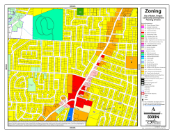


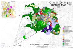
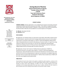
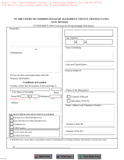


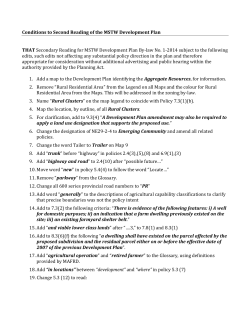
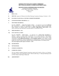
© Copyright 2026