
Sovran Drainage & Access Easement
Prepared by:
Kara Johnson
Escambia County Public Works Department
3363 West Park Place
Pensacola, Florida 32505
Crescent Lake Dam Project
Uncle Bob's Storage
A Portion of44-lS-30-3001-000-000
STATE OF FLORIDA
COUNTY OF ESCAMBIA
DRAINAGE AND ACCESS EASEMENT
THIS DRAINAGE AND ACCESS EASEMENT made this£%fr>day of /tfrf/
2015, by and between SOVRAN ACQUISITION LIMITED PARTNERSHIP, a limited partnership organized
under the laws of the State of Delaware, whose mailing address is 6467 Main Street, Buffalo, New York 14221
("Grantor") and ESCAMBIA COUNTY, FLORIDA, a political subdivision of the State of Florida, acting by
and through its duly authorized Board of County Commissioners, whose mailing address is 221 Palafox Place,
Pensacola, Florida 32502 ("Grantee").
(Wherever used, the terms "Grantor" and "Grantee" shall include the singular and plural, masculine
and feminine successors and assigns)
WITNESSETH
WHEREAS, Grantor is the owner of real property commonly known as 2295 West Michigan Avenue,
Pensacola, Florida, being more particularly described in the deed into Grantor a copy of which is attached
hereto as Exhibit A (the "Property"); and
WHEREAS, Grantor wishes to grant to Grantee, and Grantee wishes to receive from Grantor, a
permanent, non-exclusive drainage and access easement over and across portions of the Property identified in
the attached Exhibit B (the "Easement Area") for the purpose of repairing and maintaining a drainage pipe,
dam and flow control equipment and structures as constructed and installed as a part ofthe Crescent Lake Dam
Restoration Project undertaken by Grantee, together with the right of ingress and egress over and across the
Easement Area.
NOW, THEREFORE, in consideration ofOne Dollar ($ 1.00), the promises contained herein and other
good and valuable consideration, the parties agree as follows:
I.
Grantor does hereby grant to Grantee a permanent, non-exclusive drainage and access
easement over and across the Easement Area, together with the right of ingress and egress, for the purpose of
repairing and maintaining a drainage pipe, dam and Howcontrol equipment and structures, which repair and
maintenance Grantee shall perform, at Grantee's expense, as necessary to keep the same in good condition and
working order.
I
2.
Grantor also hereby grants to Grantee the right to clear, keep clear, and remove from the
Easement Area, all trees, undergrowth and other obstructions that may interfere with the location, excavation,
operation or maintenance of the drainage pipe or any related structures installed thereon by Grantee.
Notwithstanding the issuance of any permit to construct or erect any structure in the Easement Area, Grantor
agrees not to build, construct or create or permit others to build, construct or create any building or other
structure in the drainageeasement that may interfere with the location,excavation, operation or maintenanceof
the drainage pipe or any relatedstructuresinstalledthereon. Easilyremovable improvements, such as fences,
may be constructed with the priorconsent ofGrantee,not to be unreasonably withheld, conditionedordelayed.
3.
Any damage caused by Grantee, its agents, contractors,or employees, in connection with its,
its agents', contractors' or employees', use of the Easement Area shall be promptly repaired by Grantee at
Grantee's sole cost and expense.
4.
Grantee shall not use the Easement Area in a manner that interferes with or disturbs Grantor's
use of the Property, including Grantor's business operations.
5.
Grantor hereby waives any rightto compensation forGrantee's useofthe Easement Areaand
an appraisal of the Easement Area.
IN WITNESS WHEREOF, Grantor has hereunto set its hand and seal the date first above written.
SIGNED IN THE PRESENCE OF:
GRANTOR:
Sovran Acquisition Limited Partnership
By: Sovran Holding its general partner
Witness CJ^J^mji <sOL&Cs
Print Name ^Ar.shnc (^cf-'>
Witness
Print Name tftljfo^^cV^WxVAfU.X'
By
: TlZLA
Clffr'O fto^ia-Lj cgO
STATE OF NEW YORK
COUNTY OF ERIE
The foregoing instrument was acknowledged before me this \7ff\ day of tf\C\\\
nrX\jir^ r\0<\QXS
as
CtfO
, 2015, by
of Sovran Holdings, Inc.', the General Partner of
Sovran Acquisition Limited Partnership. He (£) 's personally known to me, or (_) produced current
as identification.
-AUjgxA^SP-^2 3
Signature of NotarytHlibiic
MELISSA R. ZIZZO
-Na-WZ(63H454
Printed Name of Notary PuWtary Public. State ofNew York
(Notary' Seal)
£S'?
^ 2H,nty
IS
% Commission
Expires Sept. 15, 20JQ.
ACCEPTANCE
This Drainage and Access Easement was accepted by Escambia County, Florida, on the
day of
, 2015, as authorized by the Board of County Commissioners of Escambia
County, Florida at its meeting held on the
day of
, 20
,
BOARD OF COUNTY COMMISSIONERS
ESCAMBIA COUNTY, FLORIDA
ATTEST:
PAM CH1LDERS
Steven Barry, Chairman
Clerk of the Court
Deputy Clerk
Doc #01-2860833.3
SAgi
This document approved as to form
and legat^yt/ictency.
Title id-i. fc^ly/fthti*
Date May m.Za.i
f-
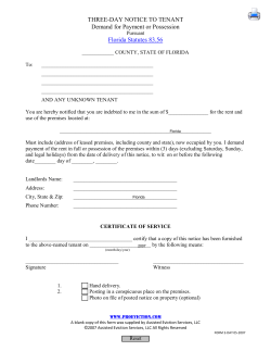
EXHIBIT A
II- 8-88 ; 17:08 ;
Spff BY:
^7
H1IU.IPS.Lm*-
f)
7lo6»16fl0i«B
INSTRUMENT 004400
ate"^,
Data' . • June22.1995
,•
Orailon
,1' '
;;: ;
'
:; ' .
•>••
' '
COLONIAL EASTOVER, aNorth Carolina General Partnership
• •
Gfrntbfs Mailing Addresst
;!• • . i ,
••!,
\ • :r
i*j
1500 North Norwood
Building C, Suite 308
- j-..i
Hurst, Texas 76054
Cranteei
| 3- g
ok mm P90220
V
Warranty n a m
j!;
,
' | :j ''
SOVRAN ACQUISITION LIMITED PARTNERSHIP,
a Delaware Limited Partnership
Mi
r
Grantee's MaPlne Address*
•i!
• }' *
.
i fl
IMtl.W
00 3S PD
POiMti.t*
-IS
ittmn.Smtma
«•
Cansideratloni
TENAND NO/100 DOLLARS (SIO.0O), and other good and valuable
consideration paid by Grantee to Grantor herein, the receipt and
sufficiency of which is hereby acknowledged by Grantor.
I •
-'•[
$i••:•• ' | :
Property (Including and with aoy and all Improvements, tenements, hereditaments and
appurtenance* thereto belooglng or In any wise appertaining)!
',! •
•)
;
!*T«t certain tract or parcel o( real property more particularly situated in
Section 44. Township I South, Range 30 West, Escambia County, Florida
• •; being more particularly described Exhibit "A" which is attached hereto and
incorporated herein for all purpose*.
.';
! .1
IT
/ * jO Reservations ftpm and Exception! to Conveyance and Warranty:
r '
<v
'•
'.
• - .
1.
Alltaxes, charges, assessments whkh are levied orassessed againtt the
subject Property tor tax year 1995 and subsequent years, which are not
!
yet due and payable, the paymentof which GRANTEE assumes.
&
2.
g
§
Wte •" '
1§S3'
••* s'5
•]\
$
:;!
I
a
future affect the subject Property. .
Those nutters as shown on Survey dated April 20.1995, made by Gary G.
Allen Registered Land Surveyor, int. hearing Job Number 95-276:
^ia« "J '..
'•
'_' gj * £ 2
-2E§2 ;
It.
.• *j •!ES s
!:•;
All (anduse toning andtub-division lows andordinances whichnow or Inthe
j
Encroachment or Sanitary Lift Station on the Southerly
""^ Wel,er|y boundary lines of adjoining property.
Encroachment of Island on Easterly boundary line.
WABRANTV DEED fJAWMMTLUSJJEAST-Wn)
«
PtploO
if
li
U- 8-B8 i
JETfTSY:
PHILLIPS
17:09
.LYTI^
7166331880 i«0
221
vssm
220040
:
lii.
1
1 '<•
Fence on Westerly lot line encroaches adjoining
property.
iv.
Concrete wall encroaches onto adjoining property on
Westerly and Southerly lot lines.
Grantor, for the consideration and subject to the reservationsIron and exceptionsto
conveyance and warranty, grants, bargains, sells, aliens, noises, releases, conveys and
confirmsthe Propertyto Grantee,Grantee'sheirs,executors,administrators,successors, or
assigns] rower. Grantor, (object to aad except tor thereservations from aid exceptions
to conveyance and warrants;, Is lawfully seised of said Property hi (be simple; thai the
Grantor has good right lad lawful authority to sell and convey the Property, aad hereby
warrant* the title to the Propertyand will dtfend the same againstthe lawfulclaims of all
persons, except as to the reservations from and exceptions to conveyance and warranty.
When the context requires,singular nouns and pronouns Include the plural.
r
\
wrmsssKS:
COLONIAL EASTOVER, a Korea Caroline
Qenoral Plrtaorahlp
• I
I ••»
1 ,1
STATE OF TEXAS
{
COUNTY OP TARRANT
I
5
i '
•Tjuj Irjtninteni was acknowledged before me on the (fU, day olJJjl/ytJ
EASTOVER,
"*' WILLIAM BRYAN CHANDLER.
~
19<2fby
General""artrterntOOLONIAXEASTC
Partner
.
\y
4 forth Cmrolln* Conacal Pactoaxihlp,
*mcv 0. lunn
NWoy Puttis
CUWof ttm
i of Texas
Votary.
Notary's Name Printed:
CflnvnMon bo. «-ssm
My corrMafon expires;
WAlWAMTf DEBD <t\*iWnAtZXttiAST.WD}
fr - A^^fa
Vtpltfl
.;. II.
SENT BY:
11-5-98;
li- 5-98 ; 17:03;
17:03 ;
PHILLIPS. LYTI
l^
PHILLIPS.
LYTI*»
7166331860;M1
or mm P50222
INSTftUMCNT 00820040
I
n.i
a^?iV!Ut^
*bt of«, uB.0,MehUM kmm m
39 Vest. Escambia countv K.V ,1fibor* prlr,« swtion 44, Tovnetip l South tW
B«t
.!«» „,„ .tortnorg'riJbTor";ay lin'. S M" " dwae» «^t« « ,,eS.
feet to q point of eurvitVre of . ™JL- t.of-Hlcb,flM amua *«* • (tame* of 111 li
Southeastern along said oSrveiJ SKS. %Tlng 0"«»" of 3679.37 feet? thence Jo
fcenUal aegla - «| dewew l? S»n?2» fS dl,t,2C0 °"-« ««* to point of SftnlsM
***** ' *•"" ?deg u I
aeeooda East for adlat.nco of 788*S iffi .S""* 5° *ortn M^»« « •StS 36
«*»<«• es ..eonda Baa?! chpJd ?"aftJL??8Hto' ^
Of Keet Shore Drivei thence «i ia,iS «i «V.t0 tb^ »'0«»aid BaaterX? tight of v4y 11™
aeconda Cast for « distance of 229 ?s/AV.; »lh,nce B0 *wth " «•«"« Mnlauies 01
wends rut for a distance Vt « ik JLitV tJ,enca «° Sout" « «ogrees 89 nlMtw a«
Second. »Mt for adi, nn« « j^g {?! j *••*• W«<»»"> 33 km « MntM 24
»«on4a
East for adl.taace Vt J7l a lal'e to^f.8° l™01." de'r,aa Sl •*"«" M
Misting mean; thence go South ss^il k°Jlie cant,c "«• «* the «»t Easterly
thence on K^4! MC0Ba3 »Mt 'S wid oen"mBi7r" '"t; «••«• WSouth 54
dKri
" •*»•*••
East /l0B?
1?»2.«»«•«
of 3i.si for
<„„a
owtance of^,19,^6*9
of 31.71 £eet; thence
go south«?41weenda
*««..«
,aid centarllno
»«id centerllne for a distance of• «a ai r-A. ^™M " "*w»lo« 19 seconds Vest ai™.«
d^H^
,l0a' 36•«"Iaeconds
SffrlWf2
degrees,™ mini.too
Vmc Jam .M«J.i^J^|*!i*."
«»</«„»'. V, M:39 fMtfdegree.
"»««Walnut
9» 5o«hI'd'
25
thence go South 95 degrees 21 L.it«9i«id C80fw^« *<* a distance of «.«2 f.-?.
; i
distance of 44.56 feetV t"enol S^L «^,S!£.%t ««"» "" ctBtirMa. £\
alt cea.c.erlln» for a dlatancr«r*« m . \ ^'l**** " aitrotea 42 seconds Vest ViL,„
IS
«?;nL'.aAvenue,
:t0*-»P>int
lntoreoetioa
v«iw,.tl>"
*f"f
forof««»ta»Ce
of
•Michigan
Bttid of
oofnt
beinn *w^» vithThJT
~T 5 "»r««ly
eurved
right
way lia- Zr
'
90(central'
HprthMeererly
81mb «& «& nAt^T* ft,wB« ara"°« of «•»-» ««?i t.2,5'
angle - 99 deoraM es I?J f*'. wf vay llM for a« «rc distance of s 76 i«f
«io«tea
32 Uad,
.Jg^Jf £££%
"VST &r,Wk««rin«13 "SS
dJirtl 564'
seconds wast
,9r , dmnnCCB0™
"•"«onord
«• ^th
degree. »?44 oilutll
!m
..
MJ^ii1 Hchi9M *»•""» »«vi», I Va4,u^ of «7« iV **••'?««•" curved righl 0?
T.Br,^^iaV5^
:. 1
; i
liS
m&cvft*
1
.
'•
V:
tOW
awr*'
r.A.IS.
wi***-
tsvntf shm
ni r**<rr>*rli|i4
??SfTSA* Co""t"-
WRIHIX "A1*
S,;;... .:!
i .•
•?
«
!
I
•
-
!"•:
U- 5-S8 i
SENT BY:.
t
RECEIPT
CASH
17:10 :
>
'< :\
—
Ml
•. lis am, wuiwl
il
71156331660 i«2
miLLirs.Lrnp-'
ESCAMBIA COUfJTY
II
i
P.O. BOX IIII
: PENSACOLA. Fi. 32595
• ! \.
!
1!
I
00002 miam
!
• I
.00
MOriT
.00
tNTA
.00 DM6
i
.
.00 PHOT
.00 NOT
.oo sncH
INSTRUMENT 00220040
(Wglitnr
.tt?;00. fill0
1
111
.00 OOCL
.00 DEP
• 'j
•;.'t
.00 MICR
.00 GLflK
• 1
.00 MI8C
BOOK 3780
PAQE 0220
FOR
4 PAOE(t)
8.TB0.00 TOTAL FHES
1
:.l
':
111
Instrument 0022QO<
BK3T99 Pg0220 P<}0221
Bk3700 Pg0222
/
i;
i '
:;
;
3 i
• I: «
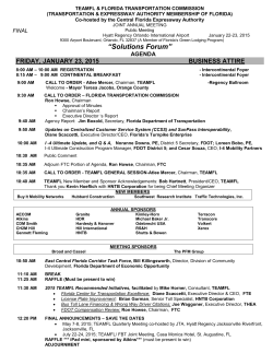
EXHIBIT B
(Follows on next 2 pages)
10
fkc«j.
pHTMAN,
Se
*r«LAZBAND^F
LAND SUKVBVOM
jwjw. MvntscumY, wrn)
RNJA£01A,fl.nSB
Rbm(BDO«S61
ro«oo«w
INC
A LE<SAL DESCRIPTION AND
SKETCH OF A PORTION OF
SECTION 44, T-l-S, R-30-W
sum i. m
i
1/ WIWIIWCJS) >
»«7~ "—-f^
-I
N
MV* UW0*. Btt Ms JBT
I20.I9»~
S OTSIBo" E
TOtl
LH<SEK17,
R/W
P.OB.
Right Of H6U,
Pont or beginning
P<?.c.
Point of commencement
P.T.
Point of tcngsnci)
SURVEYOR'S NOTES.
1.Subject to setbacks, easements aid reotrtcttoha of record.
2. This sketch is subject to any facte thdfc nVeJJ be dlsoloeecT btj a full
and accurate title March. Mo title rtork performed by this firm.
9. This sketch data not reflect or dotermtno ertierordp.
LEGAL DESCRIPTION.
CoimKmco at the eovthneet «rnar or Lot I, Block A, Unit 01
Crescent Lake Wool, a wfedMeton or a portion of Section 44tTc«rahlp I
South, Rang* 90 KH*=ot. Escambia County, Florida a* recorded M Plat
Book 7 at poo* 90 of tho public rocords or said County end bohg on
the easterlyright of way the of West Shoro Drive (OO'R/rU said point
being on a cirailar curve concave to the southeast, hotting a radius of
14&32 foot anddelta angle of 0) degrees 3eWi thence
Seuthrcosterlu (this course and the next course along sdld easterly right
or nay llrioj for an arc distance of 3O0O foot (chord distance of
30.00 feet end chord bearing of South 09 degree* B9M0rK«eU to tho
peht of kanaencui thsnes Seu&i 02 degraos SOBO'rXest for a dbtdhce
of IO.OO feet to the south line of Bnoratd eddst UHllhj Autherltai L»t
Station Site described ki Official Record Book. KM at page 73b of
tha public records of »aid county for tho point of beginning.
Thence continue South 02 degree* 9096'Kest for a distance of
2O.O0 featj thanca South 67 degrees SI90*Baot for a distance of
130.19 feet< thence North 03 degrees 3eT0'BaOt for a distance of
30.00 foot to lha south line of Croocenti Lakd Dam Site descrtbed in
Off tola) Record Book 2943 at page 967 of the pubitcrocerd» of sold
County, thence North 61 degree* StBCHest along said south lino end
tha south ttxe of sold Lift Station Site for a distance of 120.00 feat to
the peM of beginning.
All njtng and bofcg tn Section 44, Terauhtp I South, Range SO Nest.
Eacotribta County. Florida. Containing oat acr—. rroro or' toss.
PUBLIC RECORDS* TAX MAPS, RECORDBP PLAT! UNIT I CJ*59«cWr..LAte
Source ollnlormotlon: r«ST rtPB. 1,P. 9»>
/ ' j'V'.
Msoauremenls mods In occordonce to United Slates Standards.
I hereby certify that this survey was made under
Ml. M» A44»T1 «,«(- I'-SO1^. jSotwuo USlXSS
my responsible charge end meets the Stondorda Jot) Mo^SfeflSfedS
of Practice as eel forth by tho Florida Board of FB
P0.
' " "'
"^ SWKISS»'jSC*L
Professional Surveyors It Mappers In Chapter
-P0_
SJ-17.050. 3J-17.051 and 5J-17.052. pursuant Ordcrtd By RflBIM LAMBBtT
to Section 472.027 Florida Stalutoo.
'•
.1 v;Sfo&fa.lWM>
Bearing p«««»».— mqrth basbp-om-i
MB*
fATgW-WB
COORPIHATg SY8TPM WRiP IKWrMl
Encroochmenls-
David D, Olaza
Waltsr j. Glaze
Q PSM #5605
•
PSM #5190
Oate of Survey_____ .Qevouoo Reference.
PMJ
Oate ol Plot_£blfc321S. -Drown By.
Date of Revision.
—
.Qhsolwd By.
HJfr
'\)\6L<n^<L<L
LANDSUKVBWBB
4*
AND
rroKDAVBiBcnwAr.sumii
A LEGAL DESCRIPTION AND
rcxucau.n.nM)
rajMfJSBOMMI
SKETCH OF A PORTION OF
Gwft p|dEm|tfbsA9Kikiil
SECTION 44, T-l-S, R-30-W
_._
L SuSIMI la —legate, aoaaaanla and rMMstum af raoard.
a. 1*6 afcatch b a*Jn*l to n
fa*U the*ncu ba daotoaadta a M aid acaraU UU»
aaarch. Ha Mto HsS parronwd by, Ida flrnv
9.1M> iVatdi sen not raftact or MaM
'mapOvat son r. mat »>
LMOOi
Ml
PMrtof m
••OO.
•At of bajfentag
».T.
PaVdol bxajancy
Paint at acaaanar
•fcOf!
'*<
issm. eescRPno*
»*,
»^w
0£
j*?"
That atrttan of.
I****-
comma at Bo aoiOnaat t«nw ef Lot I Math r\ US
•I eroawnt LeVa rmi. a ttbeMMn of a aorttaa ol bmum<H
rwrahp I Sou*. Ranaa SO Haat, Euorcu carlo, nxtta oa rwcrdad
ti o« Book i at paja s» »l Ma n«M rater* «• aaM Cant*and
pang «n DM aaatortarg* af mj ha of Kul aura DnVa(BO'IM*
accdbcM ban as a trtalar arvs tcnum to Be Mriraatt, tanta a
radtt o) HAO laat and data aaa» a) 01 i<aara»i as«n tttnta
SnUMilarl) fU&'uferta and(aViastoana ougacttacaarb
rtds af nab
oabW
swt)
far an aw dMa«o ol SOOOteaiidaird ejtoMa al
baarttg at So» OS danaa S**?r1atl
S»40*r1attf la
WOO rati
»l and dure
UWDOBl af Maaanta OaaaaBada ca daara al SOWWaat Mr
ef 10^ M
la Vw aoribbw afCrauaal lata dan a
daacrSod h CHUM Raacrd Baak 94a d aast SSI al In* atMa
raurda a)toldCoatjidama
•Op damaBod.
Bank SI
Mdaaroaa erSCBad Ob
I aajd aaufbtha ef (rwrl
Lata den ate) far a dbbma at Ml* laab mane*Sorts SO
carta aid Via tmi tar catraaa
daarao MTTBaal lor a dMonM or SIS4 tatb than* Soda 14
davaaa USS'tlaM far a oatenta of SlOO Mai, nana* SHOi IS
c»gra*» 4CB*esat far o dktonca si 344*6 fart for Ika pot* ef
bajnttia
of BOM locbvtaita Soda It aww OWItot for o ctMoKa
al 43SJH loal U «•* nartharta r&Mal pa *» *• rOtnUni nnxu
«<U«ftood«SO^IVMvoruU»WporfB«*9a5 0 4firtar
c«rv»«o»i<»to&r»nWiU>o^orotilao»te3M1t««l
»»ddaeo angtaof 01 daa/aaa ajjlaii Sadhoiurli Km
aoaraa andVia Mitbw<aa^aaolonaaMrt|r*afHa)Haaf
MdXooi Amaja) lor on am dBtaaja of SSJO laat (tfurd
dUanoa of SSiM fart and chard baarfrdol SooUi cs dto/Mt
4CSTrW«UlBanMeoitiiO»dko^aatl*Vtalnradt&nLaor.
♦oco
Un to apew awa «*<«&• <arv» aanaowa la twnortMrt,
hoMa a rodka af 2S1S91 f»a» and dasa anda af OS da.
omthaMaflaa«iaaitfor«and^ahwad«Mai*(l
<C*re#<*«Mr**0!*<*»rdb»a^oloa4»M<»>gra..44«sr
HhiA^CkMMHarnndaanaaaOTiO'EiuiraraaUianMail
BaMa north H eaaraaa OHO'Bltt for o cbtanM al WMI
faat •»
•> txa Hd at Bigiisia.
M
Afl Mm and battfli BJcBaa 4*.1DkmM> I Soda, Pan*,
•*t,6»aitfeCa^Flarlda. C*tai*ijUaetn*.*ott
SOnaat,
ot pooa 330 of Sm)fMbOa racordi of ratoidrti Coats narlds.
NOWnCU ll/Vv.
ort"-w-2j
PUBLIC RECORDS,TAX MAPS, RBCORPEP PLAT. UNIT I CRESCENT tAKe
Sourcs of Informotlcn: rNE9T (PB. 7. P. S6)
Meosurementa made ti accordance to Untied States Standards.
I hereby certify that this' survey was mode under Me No rVHtfr.Sools l'°|0gj.
my responsible charge ond meets the Standards Job No 9l»28ft-IM
UBttss'
of Practice as sat forth by the Florida Board ol Ft?
JPO.
Professional Surveyors it Mappers in Chapter FBJ>0_
5J-17.050. SJ-t 7.061 and SJ-17.0S2, pursuant Ordered By RgBlrlL/HBgRT
to Section 472.027 Florida Statutes.
Bearing ReferenceJMSTH BASEP.
IKUkTB SYSIB4 ffiRlP
Encroachments.
David D. daze
Q PSM #5605
Wattar J. Gtaze
PSM JS19.0
Oeto of Survey.
^Iflvollcn Refercnce.
Ooto of Plat
.Drawn By—
iCnetked By.
I Dots of Rovblon-
mi
"LtS


© Copyright 2026