
Fontmell & Melbury Downs
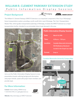
Wildlife walks… 1, 1.4 & 2.3 miles
t THE NATIONAL TRUST
Fontmell & Melbury Downs, Dorset
These Downs were bought in memory of English novelist and poet Thomas Hardy,
to protect the landscape in which his novels of the Blackmore Vale are set. Here you
will discover an open expanse of flowery downland, excellent butterfly populations
and breathtaking views.
Start: Car park – grid ref: ST886187 – maps: OS Explorer 118 or Landranger 183
How to get here & local facilities…
By bike: the North Dorset Cycle Way passes through Shaftesbury and runs just south of
the estate, passing through the village of Fontmell Magna
By bus: from Shaftesbury take the Wilts & Dorset service 182 to Compton Abbas and
Fontmell Magna
By car: from Shaftesbury head south on B3081 and follow signs to Melbury Abbas. There
is a car park on the right at the top of Spread Eagle Hill, just before the left turn to
Compton Abbas Airfield
Pub in Fontmell Magna and a restaurant at Compton Abbas Airfield. A great place for a
picnic, but please help us to keep this area special by taking your rubbish home with you.
Enjoy the far reaching views
across the Blackmore Vale and
out towards North Dorset as
Hardy once did.
NT / Clive Whitbourn
One of the best displays of
glow worms can be seen, if the
weather is good, during June
and July. There is also a
wealth of butterflies, such as
the Adonis blue (pictured
here), chalkhill blue and
marbled white.
© NT / Lucy Evershed
Things to look out for…
t Stunning views
Savour the wonderful views which stretch for miles across the Blackmore Vale, with
superb views to the north of the Saxon town of Shaftesbury.
t Melbury Beacon
At 863 feet (263 metres) above sea level, Melbury Beacon is thought to have been
one of the sites used for a warning beacon. It was also used to form part of a chain of
beacons across Dorset to celebrate the Queen’s Golden Jubilee.
t Grazing
Sheep and cattle graze the Downs to prevent grasses becoming dominant, allowing a
variety of flowers to grow. Without management, beech or ash woodland would
probably dominate the landscape. We work closely with our tenant farmers and
volunteer groups to create the right environment for the plants and animals that thrive
here.
Join a guided walk to find out
more about the natural and
cultural history which can be
explored here. Contact us on
01672 539167 for more
information.
© NT/ Clive Whitbourn
‘Marvel at the far reaching views, high on the chalk
downs, while you explore a truly ancient landscape.’
Clive Whitbourn, National Trust Warden
© Reproduced by permission
of Ordnance Survey.
All rights reserved.
Licence no. AL 100018591
Terrain and accessibility
Choice of 1ml (1.4km), 1.4ml (2.3km) & 2.3ml (3.7km) walks. Open access, so you can
explore the whole area. Well used paths and tracks include steep slopes, with uneven
surfaces which become muddy and slippery after wet weather. Dogs welcome under
close control, as livestock graze the downs. Please dispose of dog mess responsibly.
Contact us: 01672 539167 / [email protected]
Routes and directions
All three routes start from the car park at the top of Spread Eagle Hill.
Red route… easy 1 mile (1.4km)
1. From the car park walk straight out across Fontmell Down
2. Cross over the cross dyke (a bank and ditch)
3. Once over the dyke, turn left and walk through the gate. Head left, back up the down, in a
direction towards the main Shaftesbury/Blandford road
4. Finally you will come to a small wooden gate on your left. Go through the pedestrian gate
and follow the path along the road which will bring you back to the car park
Blue route… moderate 1.4 miles (2.3km)
1. Turn left out of the car park and follow the road north to Shaftesbury for about 300m
2. Go through the pedestrian gate and continue straight on heading towards the Beacon.
3. As you drop down into ‘the Saddle’ turn left through the pedestrian gate
4. Head along the top of Compton Down in a southerly direction, with the fence on your left
5. Step over a stile (secluded within the thick hedge) and step down onto the track.
6. Turn left up the track in a westerly direction which will bring you back to the car park
Orange route… moderate 2.3 miles (3.7km)
1. Turn left out of the car park and follow the road north to Shaftesbury for about 300m
2. Walk through the gate and continue straight on, following the fence line towards Melbury
Beacon. Drop down into the saddle and continue straight on up Melbury Hill.
3. Once on the Beacon take in the stunning 360o view of the Blackmore Vale, Vale of
Wardour and Shaftesbury
4. From the Beacon head left over the stile, taking a more southerly route along the fence
until you join the path back to the main road and to the car park where you originally started.
National Trust places to visit nearby:
Win Green Hill, Stourhead Estate, Dinton Park, Hod Hill,
Turnworth Down
As a charity, independent of government, the National Trust relies on the generosity of its supporters to continue caring for our countryside and wildlife,
so that everyone can enjoy the beauty of the outdoors for generations to come.
Find out more at www.nationaltrust.org.uk


© Copyright 2026