
View/Open - Cardinal Scholar
A BROWNFIELD REDEVELOPMENT IN INDIANAPOLIS A CREATIVE PROJECT SUBMITTED TO THE GRADUATE SCHOOL IN PARTIAL FULFILLMENT OF THE REQUIREMENTS FOR THE DEGREE MASTER OF LANDSCAPE ARCHITECTURE BY YUANFAN GU MALCOLM CAIRNS-ADVISOR BALL STATE UNIVERSITY MUNCIE, INDIANA MAY 2015 ACKNOWLEDGEMENTS I would like to express my deepest appreciation to the three committee members of my creative project—Mr. Malcolm Cairns, Dr. Bo Zhang and Mr. Michel Mounayar—for their support, patience, and guidance. Especially Mr. Malcolm Cairns, my committee chair, encouraged and guided me to develop this creative project. I would also like to express my gratitude to the faculty of the College of Architecture and Planning from whom I learned so much. Finally, special thanks to my parents, my girlfriend and friends for their love and encouragement during such a long process. The project would not have been completed without all your help. Table of Contents Chapter One: Introduction ............................................................................................................................ 1 1.1 Project Statement ............................................................................................................................... 1 1.2 Sub-problems ...................................................................................................................................... 2 1.3 The hypotheses ................................................................................................................................... 2 1.4 Research Methodology ....................................................................................................................... 3 1.5 Assumptions ........................................................................................................................................ 3 1.6 Delimitations ....................................................................................................................................... 4 1.7 Definition of Terms ............................................................................................................................. 4 1.8 Significance ......................................................................................................................................... 4 Chapter Two: Literature Review ................................................................................................................... 6 2.1 Brownfields in the USA ....................................................................................................................... 6 2.11 Brownfield Definition .................................................................................................................... 7 2.12 The Reasons of Brownfield Exist ................................................................................................... 7 2.13 Brownfield Impact......................................................................................................................... 8 2.14 Conclusion ................................................................................................................................... 10 2.2 Brownfield Redevelopment: ............................................................................................................. 10 2.21 Introduction ................................................................................................................................ 11 2.22 Brownfields Redevelopment Approaches .................................................................................. 12 2.23 The current situation of Brownfield Redevelopment ................................................................. 14 2.24 Conclusion: .................................................................................................................................. 16 2.3 Environmental Reclamation and Enhancement ............................................................................... 16 2.31 Water Purification ....................................................................................................................... 17 2.32 Storm Water Management ......................................................................................................... 19 2.33 Phytoremediation ....................................................................................................................... 20 2.34 Conclusion ................................................................................................................................... 22 2.4 Redeveloped Parks............................................................................................................................ 23 2.5 Conclusion ......................................................................................................................................... 24 Chapter Three: Case Study.......................................................................................................................... 26 3.1 Redevelopment of Ford Motor Company Site .................................................................................. 26 3.2 Stapleton Redevelopment ................................................................................................................ 32 3.3 Menomonee Valley Redevelopment and Community Park ............................................................. 35 3.4 Conclusion ......................................................................................................................................... 38 Chapter Four: Inventory and Analysis......................................................................................................... 39 4.1 Basic Information .............................................................................................................................. 39 4.2 Site Selection ..................................................................................................................................... 41 4.3 Site History ........................................................................................................................................ 42 4.4 Site Condition .................................................................................................................................... 43 4.41 Site Zoning................................................................................................................................... 43 4.42 Demolition and Remediation ...................................................................................................... 45 4.43 Nature Resource ......................................................................................................................... 48 4.5 Site Context ....................................................................................................................................... 49 4.51 Transportation Network and Destinations ................................................................................. 49 4.52 Land Uses .................................................................................................................................... 52 4.53 Neighborhood Analysis ............................................................................................................... 54 4.6 Site Status in the Indianapolis Urban Planning ................................................................................. 55 4.61 From the Parks and Boulevard Plan to Pleasant Run Parkways ................................................. 55 4.62 From Indy Greenways to Pleasant Run Trail ............................................................................... 57 4.7 Conclusion ......................................................................................................................................... 60 Chapter Five: Site Design ............................................................................................................................ 62 5.2 Design Concept ................................................................................................................................. 63 5.3 Master Plan ....................................................................................................................................... 64 5.31 Land Uses .................................................................................................................................... 66 5.32 Circulation ................................................................................................................................... 69 5.4 Main Components............................................................................................................................. 72 5.41 Green Core .................................................................................................................................. 72 5.42 Residential Area .......................................................................................................................... 77 5.43 Industrial Area ............................................................................................................................. 79 5.44 Office Area .................................................................................................................................. 80 5.45 Commercial Area......................................................................................................................... 81 5.5 Conclusion ......................................................................................................................................... 82 Chapter Six: Conclusion .............................................................................................................................. 84 Works Cited ................................................................................................................................................. 86 Chapter One: Introduction 1.1 Project Statement As defined by different environmental laws, the word brownfields is used to describe all abandoned, underused sites, or real property where redevelopment or reuse is complicated by the actual or perceived presence of contamination. Brownfields are mainly produced by the deindustrialization and suburbanization starting from the mid-twentieth century (APA). Today, according to the US Environmental Protection Agency (2010a), there are between 500,000 and 1 million brownfields in the USA. Brownfields come in all shapes and sizes. They include various on environmental conditions and community context as well. However, almost all brownfields share one thing in common which is having impacts on the neighborhood or city. Usually, brownfields bring natural and social environmental problems by negatively influencing the local soil, and water conditions. What is more, on account of the social problems, such as lost jobs, diminished tax base and decreased property values, the local economic is also impacted by the brownfield (EPA, “Revitalizing”). To reduce the impacts of brownfields, redevelopment programs were created and applied. In the early 1990s, brownfield redevelopment became a national priority supported by government departments and social organizations. Today, in the United States, investigation and cleanup of brownfield sites is largely regulated by state environmental agencies in cooperation with the Environmental Protection Agency (EPA). According to the EPA, its brownfields program has leveraged more than $12 billion in cleanup and redevelopment funding from the private and public sectors and created about 50,000 new jobs (EPA, “Brownfields”). 1 The site for this creative project is located in Indianapolis, Indiana, which is a typical industrial city in the rust belt. “The rust belt refers to the economic region in the NE quadrant of the United States, focused on the Midwestern states. This region was once involved in steel production or manufacturing, and then became noted for the abandonment of factories, unemployment, outmigration, the loss of electoral votes, and overall decline after mid-twentieth century, due to the decline of industry” (The Columbia Electronic Encyclopedia). From this point of view, the selected site in Indianapolis is able to extensively represent a lot of brownfields in the Midwestern states. This project will demonstrate how to reduce the negative influences of a brownfield by the way of redevelopment. 1.2 Sub-problems ● How to reduce the negative economic impacts caused by the site? ● How can the redevelopment motivate economic values for its neighborhood? ● How to minimize the negative environmental impacts caused by the site? ● How can the redevelopment benefit the environment in a large scale and for a long period? 1.3 The hypotheses Through the redevelopment, the site will offer a better living condition to the neighborhood, better management to the natural environment, and attract more people to move here to live or work. Finally, it will contribute to regional improvement of economic and environment. 2 1.4 Research Methodology The research methods include the literature review, the case study, and the field study. The literature review explores background information of brownfield redevelopment and mixeduse development. The case study specifically focuses on stream preservation and the transforming from heavy industry land use to mixed land use. It can build a comprehensive understanding of brownfield redevelopment and offers related experience, and then further supports the planning and design concepts. The field study includes site inventory and analysis and observations. The site inventory maps and records the environmental conditions, circulation, green space, existing housing conditions, and fundamental facilities, which shows the physical and cultural contexts. The site analysis explores existing strengths, problems, and potential opportunities. Part of conclusions from it can be translated into design elements and integrated into the final plan. Observation focuses on the residents’ behaviors and environmental conditions, which helps to define people’s needs and priority of different components in the site. 1.5 Assumptions ● The project assumes the site has finished the clean-up process based on the Proposed Remediation Work Plan offered by Citizens Gas and the Certificate of Completion offered by IDEM. ● The project assumes the neighborhood plan reflects the needs and expectations of most residents. ● The project assumes there will be government support for the redesign of local circulation and the redesign of the shape of the water body. 3 1.6 Delimitations ● The study does not involve the discussion of funding sources. ● The study does not involve the discussion of participants to carry out this project. ● The study does not offer maintenance program and evaluation methods. 1.7 Definition of Terms EPA: Environmental Protection Agency APA: American Planning Association IDEM: Indiana Department of Environmental Management RWP: Remediation Work Plan, a set of comprehensive program guidelines, methods or requiems that focus on removing pollution or contaminants from environmental media. VRP: Voluntary Remediation Program, providing a process for property owners, operators, potential purchasers, and third parties to voluntarily property that is or that may be contaminated. CDCs: Community Development Corporations, allows neighborhood residents to play a stronger role in the project for the community development and neighborhood revitalization 1.8 Significance This creative project has significance mainly on three aspects: enhance the environment; improve the economy; and rationalize the city plan and beautify the city image. 4 First, even after the remediation, the brownfield site still has the potential threats to environmental and public health. Therefore, the further ecological restoration and protection are significant. This creative project can improve the natural environment quality, and consequently protect the public health and nature habitat with the methods of wetland development, water purification, soil remediation and storm water management. Second, the local economy can be effectively promoted by the site redevelopment. The expected redevelopment will include a mixed-use community that offers jobs and generates tax revenue. In addition, the redevelopment will reduce the negative effects on surrounding properties so that the neighborhood’s value will be enhanced. Additionally, this creative project also contributes to some large scale and comprehensive impacts, For example, the expected increasing of the local population will effectively encourage the neighborhoods’ vitality. The beautification involved in the redevelopment process is conducive to the city’s image. Moreover, the refined circulation removes a disconnection and of the parks and trails system, helping Indianapolis to complete its urban planning. 5 Chapter Two: Literature Review This chapter mainly explores four aspects: brownfields introduction, brownfields redevelopment, environmental reclamation and enhancement, and industrial parks. Exploration about brownfield introduction includes the definition; the reason brownfields exist, and the social and environmental impacts, following the brownfields redevelopment situation and approaches in the current United States. After introducing the basic theoretical background, environmental reclamation and enhancement are elaborated on water and soil aspects. Finally, several brownfield precedents for the industrial park are selected to supply further references for the design strategies. With the help from these theoretical explorations, this creative project can address vision, goals, conceptual and master plan solutions. 2.1 Brownfields in the USA With more and more concerns about the environmental health and urban development in the modern society, brownfield—as an important concept—gets sufficient attention by the public and the government. As the foundation of this creative project, the background information of brownfield such as: how the brownfield developed, what its scope is, and how to reuse the brownfield etc., is extremely important. 6 2.11 Brownfield Definition According to the U.S. EPA through the new federal brownfields law (known as the Small Business Liability Relief and Brownfields Revitalization Act), brownfields are “real property, the expansion, redevelopment, or reuse of which may be complicated by the presence or potential presence of a hazardous substance, pollutant, or contaminant” (“Revitalizing Southeastern”). This means brownfields can be any abandoned or underused lands with environmental issues, no matter what size, shape, location or land use. “According to the US Environmental Protection Agency (2010a), there are between 500,000 and 1 million brownfields in the USA, which are mostly present in industrial and commercial sites that are abandoned or underutilized and have contamination, either real or perceived” (Solitare, & Lorie 462). EPA states that this number only includes sites for which the EPA has studied. The actual number of brownfields might be many times greater. 2.12 The Reasons of Brownfield Exist American Planning Association (APA) stated that deindustrialization and suburbanization in the mid-twentieth century are the primary two reasons that led to the large scale generation of brownfields. “Deindustrialization is a process of social and economic change caused by the removal or reduction of industrial capacity or activity in a region, especially heavy industry or manufacturing industry” (“Creating”). From the mid-late era of the twentieth century with the national economic transforming, traditional industries changed into larger modern industries. In this process, most manufacturing in the Midwestern and Northeastern United States had been reformed and centralized for a more efficient production system. However, this transformation 7 also resulted in a significant shrinking of industries and further leaded to a series of social problems like local economic decline, population loss, and urban decay in a large region. This large area in the Northeast and Midwest of United States is informally called “the Rust Belt” (Engerman & Gallman). In the belt, amounts of traditional manufacturing industries shrank, vacated, and turned to brownfields. Another reason results in the appearance of brownfields is suburbanization that occurred nearly the same time as deindustrialization. “As early as the 1920s, but mainly throughout 1950s and 1960s, the population of the urban core began to relocate in the areas surrounding many of the Nation’s cities” (Williams, “A case study”). Due to housing and commercial development, the outward migration was moving rapidly farther and farther from the urban center. “As these population shifts accelerated in the 1970s and 1980s, many cities were left with obsolete or surplus institutional and commercial properties” (Williams). Over many decades, this outward migration has left many abandoned sites, which resulted in amounts of brownfields in the urban center. 2.13 Brownfield Impact APA stated that brownfield impacts are based on the property’s size, location, and level of contamination. For instance, brownfields in a dense urban community usually have long-term environmental impact and significant economic effects for the neighborhood; isolated brownfields have less social impact but more environmental one (APA, “Creating”). 8 “Major aspects impacted by brownfields include pollution, public health, economic, safety and blight” (APA, “Creating”). Pollution: air, soil, and water can all be polluted by the brownfield contamination. Harmful substances might be left by the past industrial or commercial activities, migrating through the air and groundwater across sites (APA). Public health: soil, air, and water exposed in the contaminated sites may produce serious negative effects on the health of nearby residents or workers (APA). Economic: “abandoned sites generate no tax revenue, and vacant buildings and lots can have negative effects on surrounding property values.” Particularly for the low-income communities, “the threat of costs associated with required environmental assessments and cleanup deter private investors” (APA). Safety: abandoned buildings and lots may produce safety threats to the surrounding neighborhood. “These neglected spaces are often the site of illegal and dangerous activities receiving unwanted attention from drug dealers, unauthorized salvagers, arsonists, and illegal trash dumpers” (APA). Blight: when the brownfield sites are abandoned by the owners without maintenance, they would “deteriorate and often become eyesores.” The boarded-up construction and overgrown, trash-strewn lots give negative impressions for other well-maintained neighborhood (APA). 9 2.14 Conclusion Brownfields negatively influence the natural and social environment with pollution impacts through soil, air, groundwater or surface water. Issues posed by brownfields have impacts on the local condition, but also for the surrounding neighborhood. Besides the health and environmental risks, brownfields are usually associated with “abandoned and unsafe buildings, lost jobs and diminished tax base, decreased property values, vandalism and criminal activity, and other signs of blight” (EPA, “Revitalizing Southeastern”). On the other hand, a brownfield can also be considered as an opportunity if it is cleaned up, redeveloped and reused with functions. Brownfield redevelopment helps to take environmental pressure off, enhance the life quality, and probably increase the job opportunities. The following sections explore the current situation of brownfield redevelopment in the United States. 2.2 Brownfield Redevelopment: As EPA estimated, there are between 500,000 and 1 million brownfields in the USA. How to redevelop brownfields is important, especially for those in the community and urban center. In Solitare and Lorie’s article, they supply an estimated survey conducted by the US Conference of Mayors in 2008: among “24,896 brownfield sites in 188 responding cities, approximately 1578 sites (in 150 cities) have been redeveloped, with another 1235 in process (in 168 cities)” (463). 10 2.21 Introduction “Brownfield redevelopment became a national priority in the early 1990s supported by federal initiatives such as the Brownfields Economic Redevelopment Initiative (1993) and the Brownfields Action Program (1995)” (Williams, “A case study”). “In January 2002, the Small Business Liability Relief and Brownfields Revitalization Act were passed, reaffirming a national level commitment to cleanup, redevelop, and reuse brownfields around the country.” After that, several states developed legislation to promote brownfields development, including Minnesota, Pennsylvania, and Alabama. Several municipalities and counties received grants from the U.S. Environmental Protection Agency (USEPA) to deal with brownfields cleanup and redevelopment (Williams). Right now, in the United States, “investigation and cleanup of brownfield sites is largely regulated by state environmental agencies in cooperation with the Environmental Protection Agency” (EPA). Together with local and national government, the EPA can provide technical help and grants for site cleanup, environmental assessment, and job training activities. In addition, this brownfields program also “seeks to strengthen the marketplace and encourages stakeholders to leverage the resources needed to clean up and redevelop brownfields.” According to the EPA, this program has “leveraged more than 12 billion dollars in cleanup and redevelopment funding from the private and public sectors and created about 500,000 new jobs” (Williams). 11 2.22 Brownfields Redevelopment Approaches Conventional approaches of brownfield redevelopment have been applied for years. Except the introduction of the traditional way, this section explores a new community-based redevelopment—community development corporations (CDCs). 2.221 Conventional approach Most brownfields have been redeveloped in the conventional approach “in which the redevelopment had been handled similarly to a standard land development”, except that the brownfield had to deal with some environmental contamination, considering public protection and environmental health (Solitare, & Lorie 463). In conventional approach, to redevelop the brownfield, typically an effector stakeholder is in charge of the process. This means “the effector identifies sites for redevelopment, priorities, uses, and makes the key decisions regarding remediation and reuse, without much involvement of the affected stakeholders” (Solitare, & Lorie 463). All the important project decisions include actors might make goals and objectives outside of the brownfield vicinities. To examine how effective the brownfield redevelopment is, one concept is mentioned— environmental justice. Solitare and Lorie states that environmental justice “encompasses the need to increase economic opportunities, decrease environmental risks, empower, and improve the quality of place for minority and low-income residents of neighborhoods characterized as having an unfair share of locally unwanted land uses (LULUs)” (Solitare, & Lorie 461). Brownfields are underused and abandoned, which are one of LULUs. The conventional approaches to redeveloping brownfields have shortcomings. They are difficult to achieve environmental justice, 12 lack of positive neighborhood impact, and have less community participation. In this case, new approaches are promoted to solve these problems. One of them is community development corporations (CDCs), which is suitable to solve diverse issues in this creative project site. 2.222 Community-based brownfield redevelopment Evaluations for the brownfield redevelopment typically address on several aspects: economic impact, public health improvement, public participation, and market transactions. Solitare and Lorie state in their article that environmental justice is not the only judgment for an improved brownfield redevelopment, the four above aspects are all important to evaluate the approach. Three characteristics of the community-based brownfield redevelopment are described in their article, considering these judge aspects. First, different from the conventional approach, community development corporations (CDCs) “typically perform services in the community, and usually have local residents as either board members or advisors in some capacity.” This means neighborhood residents may play a stronger role in the project and bring more benefits to the community. Second, “meaningful participation can change the balance of power between stakeholders, and the resulting community empowerment can be an agent for environmental justice.” Third, the main purpose of a community-based redevelopment are “community development and neighborhood revitalization,” not only for the direct economic benefits, but also the community assets such as “reduced blight, health improvements, walkability, aesthetics, and service to local residents” (Solitare, & Lorie 466). With these characteristics, if CDCs partly address job-trainings during the process, the likelihood of new jobs would increase for local residents. 13 Although a CDC is not perfect for the brownfield redevelopment, it at least supplies more opportunities through diverse aspects, such as an economic impact, public health improvement, and public participation. As Solitare and Lorie stated in their article, “a CDC may be best suited, and most interested, to raise awareness about brownfields, educate residents, engage other stakeholders, and plan for and promote the redevelopment of sites” (467). Meaningful examples in the USA are offered. “Dorchester Bay Economic Development Corporation (Boston, MA), Bethel New life (Chicago, IL), and Avenue Community Development Corporation (Houston, TX) have redeveloped brownfield sites and built housing or commercial facilities that have brought jobs, economic activity, and new affordable housing to weak market areas” (Solitare, & Lorie 467). 2.23 The current situation of Brownfield Redevelopment Abstracted from a previous estimation, United States has about “24,896 brownfield sites in 188 responding cities, and approximately 1578 sites (in 150 cities) have been redeveloped, with another 1235 in process (in 168 cities)” (Solitare, & Lorie 463). For decades before the twenty-first century, many contaminated brownfields stayed unused because the cost of cleaning up to safe standards is more than the benefit from the redeveloped land (Williams). Right now, with the technology development, brownfields redevelopment has become more common for the environmental enhancement. More federal and state programs supply funding to support brownfield cleanup and restoration. However, the estimated data still shows a serious problem: large amounts of brownfields are still abandoned and unused. From APA, “the strict liability provisions of the first federal cleanup laws for contaminated properties” help to explain why so 14 many brownfields still remain today. “In the1970s and 1980s, the federal government passed a number of important pieces of legislation to address contamination at former industrial sites.” Two of those acts are mentioned as important discussions: the Resource Conservation and Recovery Act (RCRA, Pub. L. 94-580) in 1976, and the Comprehensive Environmental Response Compensation and Liability Act (CERCLA) in 1980 (APA). These laws made past, present and future owners potentially liable for cleanup, causing many owners to abandon properties or declare bankruptcy to avoid taking on the costs of site remediation. On the other hand, cleanup standards require sites to be restored to pre-development levels of contamination, which magnifies the hesitant of new investors and the risk of investment (APA). To encourage owners to remediate brownfields, “47 states have created state Voluntary Cleanup Programs (VCPs).” These programs usually provide a streamlined support including cleanup process and cap future liability to attract redevelopment. Additionally, “the USEPA, through memoranda of agreement with individual states, has given states primacy over brownfields cleanup” (APA). Although diverse programs try to encourage brownfields redevelopment, the truth is that there are still amounts of brownfields remaining vacant. In this situation, creating a lively redeveloped land with multiple uses in brownfield site becomes extremely significant. This creative project aims to redevelop the current brownfield site into a vivid presence with residential, commercial, and industrial functions, addressing the importance of the green buffers and ecological approaches. 15 2.24 Conclusion: The brownfields redevelopment has become a national priority for decades, and a series of policies and programs has been enacted to support it. Benefits of brownfield redevelopment keep getting higher than the costs; that drives more and more governments and investors setting their sight on this area. Under this promising environment, the creative project about the redevelopment of a brownfield in Indianapolis is reasonably in prospect of success. About the approach, compared with the conventional approach, the CDC addresses more benefits for the community and neighborhoods. In consequence, documents those can represent people’s willing, like community survey, neighborhood plan or best-highest analyzes, are worthy to be concerned. 2.3 Environmental Reclamation and Enhancement For brownfield redevelopment, environmental reclamation is critical. This section mainly introduces three approaches for enhancing the environment quality: water purification, storm water management, and phytoremediation. Water purification and storm water management are both focus on water quality while phytoremediation treatment is more about the soil quality enhancement. Usually, the clean-up process of a brownfield goes ahead of the redevelopment, and the water and soil conditions will be remediated into an acceptable level. However, for a better environmental condition, some further treatments are needed and can only be applied in the redevelopment process. All the three treatments mentioned in this section are long-term reclamation and were applied in this creative project. 16 2.31 Water Purification Water Purification is a useful way for environmental enhancement if brownfields have water body onsite such as wetlands, creeks, or drainage depressions. It is a long-term process to purify the polluted water, helping to create a regenerative living condition. For better representation of how water purification works, this section explores Shanghai Houtan Park as an example. It was completed in 2010, and once was industrial brownfield. After the successful redevelopment, Houtan Park “cleans up to 634,000 gallons of polluted river water daily, improving the water’s quality from Grade V (unsuitable for human contact) to Grade II (suitable for landscape irrigation) using only biological processes” (Rottle). Figure 2.1 Shanghai Houtan Park Concept (ASLA) 17 Figure 2.2 Water Purification of Houtan Park (ASLA) Houtan Park was designed as a regenerative living system that “treats polluted river water, mitigates urban flooding and increases habitat and biodiversity” (Rottle). Learning from Houtan Park, how to form a rich living purification system is imperative. Process includes sedimentation, aeration and oxygen, purification of soil, plants and microorganism. “Cascades and terraces are used to oxygenate the nutrient rich water, remove and retain nutrients and reduce suspended sediments while creating pleasant water features.” “Different species of wetland plants were selected and designed to absorb different pollutants from the water” (ASLA). Doctor Yu summarized that designed cascades and terraces with diverse plants slow the flowing water to 18 remove pollutants, nutrients, and sediment gradually. Repeatedly, the polluted water is purified with the natural system (Yu, “Ecosystem Design”). To reduce the cost and maintenance, the design can use a large number of native species, sometimes even local crops, for water purification and biological production. For this creative project, water purification will be applied in the design through selecting specific plants and topography formations along the onsite creek. Water from upstream will be purified through the design system and finally flow out the site. In a city-scale view, this kind of system enhances the environment of the brownfield, but also benefit to the city water system in a sustainable way. 2.32 Storm Water Management Storm Water Management (SWM) has changed over the decades. Randolph (247) listed all the SWM changes about objectives, control measures, design methods, and program ordinances and financing through four phases: before 1970, 1970s-1980s, 1990s-2000s, 2010present. As Randolph summarized, “control measures have evolved from centralized structures to more distributed and onsite practices; methods have also changed bring structural (pipes, drains, and gutters) to more biological (native grasses, rain gardens, natural infiltration); practice of stormwater have moved from taking water away from an area to keeping it in the initial area for natural infiltration and drainage” (248). In modern society, sustainable stormwater management is highly encouraged, usually integrated with “flood damage mitigation, water quality, stream restoration, and sustainable and livable community design” (Randolph 247). 19 1972 Clean Water Act addressed “goals of fishable and swimmable waters and pollutant discharge elimination” and stated “foundation of the program was water quality standards.” “Nearly all communities with stormwater systems must obtain permit,” and “develop a stormwater management plan that meets EPA criteria (addresses outreach, education, construction projects, post-construction operations, illicit discharges, and pollution prevention).” “In 2007 the Government Accountability Office issued a report on the impact of EPA permit program stating its inefficiency” (Randolph 249). For restoring streams and watersheds in urban, the report stated that the project “cannot fix the problem only by treating the stream; it must fix the land use” (Randolph 250). A creek flows through the site of this creative project and divides the land into several parts with different land uses. Specific principles of land use design and stormwater management will be abstracted to guide the design strategies through the following aspects: neighborhood design, onsite infiltration, sustainable treatments etc. The design part will present all the details. 2.33 Phytoremediation Treatments must be done at brownfields, no matter for water or soil. This section introduces a type of soil environmental reclamation which is called “phytoremediation.” Boguski, Leven, and Martin state that “Phytoremediation is the use of plants to reduce environmental risks due to contaminants in soil, sediment, surface water, and groundwater.” “The plants may remove, transfer, stabilize or destroy contaminants depending on the nature of the plants and contaminants.” It successfully works to “moderate environmental impacts by removing organics and salts in surface soils; stabilizing metals, other contaminants, and soil, and controlling and 20 removing contaminants in surface and groundwater.” Figure 2.3 shows the basic principles of phytoremediation. Figure 2.3 Diagram of Phytoremediation (Boguski, Leven, and Martin) Typically, phytoremediation has different mechanisms, such as the phytoextraction, rhizosphere biodegradation, phytostabilization, and hydraulic control of groundwater. Basically, they all use specific plants to remove or break down contaminants with diverse ways. Thus, specific plants will be selected for the creative project design. Like phytoextraction, it is “the use of plants to remove contaminants from soil, sediment, or water into the above-ground plants tissue.” Suitable plants for phytoextraction could be barley, hydrangea, rapeseed, sunflower, tall fescue etc. (Boguski, Leven, and Martin). “Rhizosphere Biodegradation is the process whereby contaminants break down in soil or ground water surrounding the plant roots.” This means that these plant-produced chemicals can “serve as nutrients for soil microbes that live near the roots of the plant.” Phytostabilization mainly involves with heavy metals. Hydraulic control of 21 groundwater is achieved by trees which transpire significant water vapor. “Hybrid poplar trees especially successful at controlling shallow ground water plumes” (Boguski, Leven, and Martin). Consequently, vegetation buffers and bioretention cells are significant and important in brownfield redevelopment. They can help to enhance the environmental reclamation in a sustainable way. Phytoremediation is very useful in a sustainable view, but it also has many limitations, considering the cost, toxicity, leaching, contamination depth or type, land use size, shape, redevelopment timing etc. In this creative project, these limitations will not be considered. Specific plantings will be selected for the design, especially in the central green buffer strip which separates the industrial and residential area. 2.34 Conclusion In this creative project, environmental problems mainly focus on the quality of the water body, management of storm water, and further reclamation of soils. For water purification, designed topography and selected species will be applied to the creek in the site. All the water will be purified through the system, including the water flowing into the site and harvested water onsite. Through this process, the project is able to achieve a significant goal, which is to benefit the larger scale environment. For storm water management, both structural and biological methods will be applied to the site. In this way, the stormwater can be efficiently harvested, partly retained on the site, and gradually infiltrating into the watershed. This leads to the improvement of the environmental quality, but also reduces the pressure of the Indianapolis drainage system. For phytoremediation, diverse vegetation will be selected especially to centralize, absorb, and break down the contaminants in the soil. This is a further reclamation 22 process after the Remediation Work Plan (RWP). For the long-term consideration, redeveloping a brownfield with the phytoremediation will contribute to a much better environmental quality than a typical reclamation process. Through the selected three reclamation methods, this creative project can serve a better environmental reclamation involved with the landscape design, demonstrating a good brownfield redevelopment in Indianapolis. 2.4 Redeveloped Parks This section evaluates possibility of developing a brownfield into a park and use cases to explain different types redeveloped parks. Based on this study, the creative project could select a suitable direction to plan the green space on the site. The site of this creative project was once the Indianapolis Coke, right now is an abandoned brownfield with industrial history. “Redevelopment of such sites takes place between two extremes.” “One is clearing the land, using it for completely new development without reference to its industrial past; the other is preserving the total facility as a public using facility” (Hardy 32). Amounts of diverse land uses can be applied between these two situations, such as “housing, retail stores, offices, and entertainment venues.” This creative project tries to redevelop varies of lively land uses; bring healthy back to the site, at the same time retaining much of the original industrial background. Hardy introduces a few representative examples of brownfield redevelopment as the park. Like Sloss Furnaces in Birmingham of Alabama, it is “the only twentieth-century blast furnace in the U.S. being preserved and interpreted as a historic industrial site.” In 1980, the Sloss Furnaces was redeveloped as “A Museum of Modern Times,” presenting the site as a home for 23 “educational, cultural and recreational programs.” “The two four-hundred-ton blast furnaces and forty other buildings” offer an art celebration for the community. Some old machines are used to make metal sculptures, which forms a metal arts program to offer “workshops, open studios, exhibitions and conferences on metal sculpture.” During the process, residences and visitors can participate in the walking tours and feel the site history (Hardy 33). Another famous redeveloped park is the Chelsea High Line in New York City. It is “an artifact of the railroad era, an elevated steel viaduct that threads its way down one and a half miles of lower Manhattan’s for West Side” (Hardy 35). The High Line supplies an enjoyable platform for the river and city view. Once was an elevated freight railroad, it is successfully redeveloped to a comfortable landscape park, combining “old and new, built and bucolic, commercial and cultural” in the profoundly urban environment. The site of this creative project is a heavy industrial area with significant nature resource inside. Based on the above precedents, this creative project has the opportunity to create a redeveloped park combining the Coke Plant’s stories with restored natural resources. 2.5 Conclusion Literature review contributes to the whole process of the creative project generating. Through exploring the theoretical information, the general concept is addressed as well as goals and objectives, and the direction of the project development. At the same time, experience, design methods, and problem solutions are abstracted for the design process. In this chapter, brownfield background and redevelopment sections supply sufficient basic knowledge, becoming the foundation of the whole creative project. The sections of environmental 24 reclamation and enhancement and industrial park explore two major components of the creative project. Consequently, these theoretical explorations effectively support the development of this creative project. 25 Chapter Three: Case Study This Chapter offers three case studies that have bearing on the creative project: Redevelopment of Ford Motor Company Site, Stapleton Redevelopment, Menomonee Valley Redevelopment and Community Park. Redevelopment of Ford Motor Company Site is a typical brownfield redevelopment project, which transforms an abandoned heavy industry area into a multi-functional community. Stapleton Redevelopment develops a large residential area on an abandoned airport, and a significant distinction in this case is the steam reclamation and preservation. Menomonee Valley Redevelopment and Community Park is a brownfield project that focuses on “Green Renewal” which is mainly about environmental remediation and sustainable design. These three cases supply useful references on diverse aspects, which give the creative project an expanded view of how brownfield redevelopment can benefit the site and its neighborhood. 3.1 Redevelopment of Ford Motor Company Site Redevelopment of Ford Motor Company Site transforms a 122 acres abandoned automobile manufacturing site in Saint Paul, MN into a multi-functional community. This project comprehensively demonstrates the principles, process and methods for brownfield redevelopment. Its experience is able to guide the developing process of the creative project, because from background, site statement, vision and goals to analysis, concept generation and master plan development, each step can be used as the reference in brownfield redevelopment. The following paragraphs are cited or summarized from the report of Redevelopment of Ford Motor Company Site: Ford Motor Company Planning Study: Phase 1 Final Report, showing the process and experiences of this project. 26 The Ford Motor Company site is located within the Highland Park neighborhood and adjacent to the Mississippi River in southwestern Saint Paul, Minnesota. Started in 1924, the Ford Motor Company had been operated as the assembly plant for over 80 years, till 2008. After acknowledging the great responsibility and opportunity of redeveloping the Ford site, Saint Paul launched its process to work with Ford Motor Company, local neighborhood groups and citizens to shape a vision and a range of planning options for redevelop the Ford Site. The vision describes the redeveloped Ford Site that “it will balance economic, social and environmental sustainability in a way that conserves and improves the qualities and characteristics of the unique Highland Park neighborhood and Mississippi River Valley Corridor, in which it sits, while advancing the City’s economic wealth and community goals, resulting in a forward-thinking 21st Century development” (EDAW). Following the vision for the project, a series of site analyses was completed by different agencies to identify some of the key physical constraints and opportunities that influenced the character of the existing site and the neighborhood context. These included Elevation Analysis, Current Land Use, Current Site Zoning, Mississippi River Critical Area Overlay, and Surrounding Neighborhood Architectural Assessment. 27 28 Ford Motor Company Site (EDAW) Figure 3.1 Site Analysis of The last step before the scenario generating is to determine the development potential. In the report, the project team using the data from the market study respectively raises a series of development potentials on aspects of the industry, office, retail, and residential. Figure 3.2 Development Program of Ford Site Redevelopment (EDAW) The final Ford Motor Company Planning Study offers five optional scenarios. One of them is called Flex Tech. “This scenario provides a higher percentage of land for an urban campus within a mixed use setting. Such uses could be educational and learning, research and development, and/or traditional office. The campus will be organized around a central green which also serves as recreational space for the residential community. Onsite water retention/detention and best management practices would be employed. All building on this Site would be required to achieve LEED Certification. New retail will be accommodated along Ford Parkway and along the first block of Cretin south of Ford Parkway. The ball fields will be moved 29 from their current location to the Canadian Pacific rail yard, which will be incorporated into a larger park” (EDAW). 30 Figure 3.3 Master Plan and Analysis of Ford Site Redevelopment (EDAW) 31 3.2 Stapleton Redevelopment This project transforms a 4,500-acre brownfield site, formerly Denver's airport, into mixed-use community. The vast majority of space provides for residential uses which is expected to offer living units for near 30,000 residents. Stapleton Redevelopment has promoted a community vision that combines a sustainable design philosophy with an urban extension of the City's historic development patterns (AECOM). Figure 3.4 Before and After of Stapleton Community (Roberts) 32 Figure 3.5 Land Use Map of Stapleton Community (Forest City Stapleton, Inc.) Westerly Creek Park is a part of the Stapleton Redevelopment focusing on environment remediation and sustainable urban planning. The creek was buried for nearly 40 years, 30 feet below Stapleton International Airport’s East-West runway until the Stapleton Redevelopment daylights it. Figure 3.6 Representational Cross-section Depicting Project Before and After Conditions (LAF) 33 Figure3.7 Process of Westerly Creek Development (Jessica Canfield) Westerly Creek Park is regarded as a successful ecological restoration project because it improved the site’s water conveyance capacity, increased stormwater infiltration in subwatershed, improved water quality of downstream fluvial systems by increasing dissolved oxygen and decreased suspended sediment and covering by native prairie vegetation. It sequestered much more carbon than if hard pavement had been used (“Westerly Creek”). Figure 3.8 Before and After of Westerly Creek (LAF) 34 As a case study of brownfield redevelopment, Stapleton Redevelopment not only demonstrates how to apply community planning and urban design into brownfield redevelopment, but also inspires people how can the brownfield redevelopment contribute to ecological restoration. 3.3 Menomonee Valley Redevelopment and Community Park In early 20th Century, on the strength of an expanding railway system, the Menomonee Valley attracted substantial manufacturing and industrial activities. However, the importance of railroads began to decline and finally led to the bankruptcy of Milwaukee Road in 1985. The abandoned property with serious environmental issues had not been redeveloped until 1998 when “renewing the valley” program was launched by the city of Milwaukee (“Menomonee Valley— Storm Water”) Figure 3.9 Historic Photographs of Menomonee Valley (“Menomonee Valley Industrial Center”) 35 The redevelopment plan addressed a 140-acre light industrial redevelopment with a public park and shared stormwater treatment area as the centerpiece. “The park creates over 60 acres of recreational space with revitalized landscape and habitat along the Menomonee River. The shared stormwater facility results in a higher development yield for individual property owners, allowing the City to remain extremely competitive when attracting businesses to the Valley” (“ Menomonee Valley Redevelopment”). Figure 3.10 Menomonee Valley Redevelopment and Community Park (LAF) The central green space plays a significant role in the project. It not only appears as a remedial solution, after removing more than 80% of total suspended polluted solids, but also organizes the entire development as one singular stormwater management system, which can handle days of extreme rainfall without dumping overflow into the river (“Menomonee Valley— Stormwater”). 36 Figure 3.11 Before and After of Menomonee Valley (LAF) Besides, functioning as a remedial solution and a stormwater management system, the park has livelier side as well. The center Chimney Park within twin chimney stacks, recalls the Valley’s industrial past. The main lawn of the park is flanked on the north by soccer fields. What’s more, basketball courts, athletic fields, picnic areas and river access make it a pleasant spot for employees to relax and families to play. Public art is incorporated throughout (“Menomonee Valley—Stormwater”). Figure 3.12 The Center Chimney Park (“Menomonee Valley Industrial Center”) 37 In this project, the central green space becomes the key element, supported by all other systems such as: circulation, sustainable design, zoning organizing etc. From this point of view, this case proves the feasibility of taking a green space as the core of the brownfield redevelopment. Moreover, this case demonstrates how to arrange different land functionally around the central green space. 3.4 Conclusion From different views, the three case studies in this chapter offer practical references for this creative project. The redevelopment of Ford Motor Company Site ultimately displays the process of brownfields redevelopment and presents a typical example of multi-function community development. Stapleton Redevelopment shares significant experiences of ecological restoration and protection, inspiring the design of water system for this creative project. Menomonee Valley Redevelopment and community Park helps the creative project to form the concept, developing the green space as the core of the site. Consequently, the precedents, from general to specific, provide comprehensive support for the development of this creative project. 38 Chapter Four: Inventory and Analysis 4.1 Basic Information The site is located on the southeast side of Indianapolis. It was the main component of Indianapolis Coke Site owned by the Citizen Energy Group. The approximate 111-acre site includes two adjacent sections: Main Plant and Twin Aire, an abandoned drive in movie site. A creek named Pleasant Run goes across the Main Plant from northeast to southwest with the limited green buffer along it. The site is surrounded by a mixed-use area which primarily contains residential and commercial lands. “The Site has Interstate access from both I-65 and I70 within 1.5 miles to the west of the property and I-465 accesses from approximately three miles to the east of the property” (“Proposed Reuse Vision.”). 39 Figure 4.1 Site Location 40 4.2 Site Selection The selected site is located in Indianapolis which is a city like many others in the Midwest whose decline of industry includes it in the rust belt. From this point of view, finding an appropriate solution for this project will supply a positive reference for the other brownfields in the rust belt. As mentioned in the second chapter, “In mid-late of the twentieth century with the national economic depression, traditional industries changed to larger modern industries. Most manufacturers in the Midwestern and Northeastern United States had been centralized, forming a larger zone called the rust belt.” (“Creating”). Some major cities within this zone, like Chicago, Indianapolis, Baltimore, Pittsburgh, Buffalo, Cleveland, and Detroit witnessed the shrinking of industry at that time. Some social problems, such as city shrinking, economic decline, population loss, and urban decay, still remain long-term impacts to their cities (Figure 4.2). Brownfields are one of the products from these impacts. The brownfields in Indianapolis share a series of problems and characteristics with other brownfields in the rust belt. Consequently, selecting and redeveloping a brownfield in Indianapolis may demonstrate an approach of reusing the brownfields for others in the rust belt. 41 Figure 4.2 Change in Total Number of Manufacturing Jobs in Metropolitan Areas, 1954-2002 (“Rust”) 4.3 Site History The site is part of Indianapolis Coke Site. Indianapolis Coke is the Manufacturing division of Citizens Energy Group. Its primary product is coke with manufactured gas and various chemicals. “Coke is a solid carbon material that is used as a fuel primarily by steel mills and foundries” (“ Plant History”). In1907, the Gas Trust originally bought the 22-acre land outside of the city to build the coke ovens. After that, this coke plant had been serving Indianapolis with energy sources for almost one century until it closed in July 2007. 42 1909 Indianapolis Coke started to operate and produce coke and gas for heating and other purposes in the following decades. 1950s Coke oven started to be phased out of the gas distribution operation due to the introduction of natural gas transported to Indianapolis via interstate pipelines. 1998 As the price of coal escalated, Indianapolis Coke completely phased the coke oven gas out of the gas distribution system. 2006 During the last full year of production, the facility produced well over one-half million tons of coke for use in the steel and foundry industries. 2007 Indianapolis Coke ceased operations after nearly 99 years of service to the Indianapolis community. Table 4.1 History of Indianapolis Coke (“Proposed reuse vision”) Figure 4.3 Constructing the First Permanent Battery in1909 (Citizens Energy Group) 4.4 Site Condition 4.41 Site Zoning 43 The site consists of Twin Aire and Main Plant. These two sections with different land uses are separated by the Pleasant Run Parkway. “Twin Aire” is an abandoned 28-acre drive-in theater. Since ceased operation in 1993, this property has been well fenced and secured. It is basically a green open space with some remaining paved areas near the east entrance. The only structure, viewing screen, was removed, and now it is an entirely vacant property ready for the reuse (“Proposed”). “Main Plant” is an 82.5-acre site for former industrial coke manufacturing facility. In the center of this section, the main body of the coke plant was structured here. “Processes conducted in this area are consisted of industrial coke manufacturing and by-products recovery and storage” (“Proposed”). The space near the east corner used to be the coal storage, and coke transfer and loading area. The space near the west corner, between the Pleasant Run and Pleasant Run Parkway, was used for gas supply operations. It contains several gas storage facilities, one gas plant, and a large train station. Along the north and south boundaries, there are two belts of office spaces, containing a storage warehouse, administrative offices, and a few parking lots. The whole section is almost level, except for the three to five feet elevation changing along the stream banks. “Pleasant Run Creek” is basically an urban ditch through the site. This segment is a "missing" link in the City’s Park and Boulevard System, designed by George Kessler in 1908. To the Southwest Pleasant Run Parkway connects to Garfield Park and to the northeast connects to Ellenberger Park. Site Zoning contributes to a better understanding of the site by providing more detailed information and space distribution. What is more important is that fundamentally, the former 44 usages of each space determine its environmental quality which further affects the redevelopment program. Figure 4.4 Site Zoning Diagram 4.42 Demolition and Remediation The remaining structures can be divided into four parcels: coke manufacturing facilities, gas supply facilities, wastewater treatment facilities, and office buildings. According to the Demolition Plan, published by Citizens Gas 2007, all the structures on the site will be demolished. For supporting the coming site redevelopment, demolition of facility structures was planned to be completed by 2012. However the demolition was still in process in 2014. The 45 creative project assumes that the demolition follows the schedule, and the site is ready to redevelop. In the Main Plant site, the coke plant consistently operated on coke manufacturing for 99 years. Along with this operation, this heavy industry never stopped impacting the environment. To address the environmental issues, Citizens Gas has participated in the Indiana Department of Environmental Management’s (IDEM) Voluntary Remediation Program (VRP) to direct cleanup efforts at the Main Plant property. A Remediation Work Plan (RWP) is developed to guide the remediation process (“Proposed”). The expected outcome is reclaiming the environment quality to the standard level, where the redevelopment or reusing is allowed by the environmental policies. The creative project assumes that these remedial efforts will make this site ready for the redevelopment, and the remediation work will complete on time. The Main Plant site is divided into four parcels: Main Plant, Southeastern, Gas Supply, and Coal Storage. The main solution for remediation work is “the plan proposes to replace limited areas of contaminated surface soil to a depth of 1 foot below ground surface with clean soil and to perform groundwater monitoring. Existing surface soils that meet industrial clean-up criteria will remain” (“ Prospect Remediation”). The following paragraphs are analysis and recommendations (Figure 4.5) based on the report of Remediation Work Plan (RWP). Main Plant: this parcel is located in the center of the site between the Pleasant Run and railway on the southeast boundary. The main facilities of coke manufacturing are constructed here. This is the place where the coke manufacturing operation takes place. The land in this parcel has the most serious environmental issues. Even after the remediation, it might still have the healthy threat. Thus, this parcel is recommended to be redeveloped into 46 the industry land use. Coal Storage: this parcel is located on the northeast corner of the plant. Investigation has been conducted and still continues. The situation here is similar as the Main Plant. The storage of slag and coal heavily impacted the environment. After remediation, redeveloping this parcel into industry area will be the best choice. Gas Supply: it is located on the west side of the plant and borders the Pleasant Run Creek. This parcel was used for gas supplying, and the most area was covered by a large train station. That means the soil here is less polluted compared to the Main Plant. However, since the land use was heavy industry before, this parcel is recommended to be reused as industry as well. Southeastern: This parcel is located on the north side of the plant and is bordered by Southeastern Avenue and Pleasant Run Parkway. This site is used for waste water treatment and office building. These two kinds of land uses generate the least pollution among the four parcels. It is not suitable for residential development, but its environmental quality is good enough for open spaces and commercial development after remediation. 47 Figure 4.5 Environmental Quality Diagram 4.43 Nature Resource The most remarkable natural resource in the creative project site is the Pleasant Run and its green buffer. Starting at the Shadeland Avenue, the Pleasant Run flows into the site from the northeast and out to the southwest, finally into the White River. The Pleasant Run Creek and its green buffer on both sides form the Pleasant Run green corridor, which is one important part of both the 1908 Kessler’s Park and Boulevard Plan and 2012 City’s Indy Greenways Plan. It connects multiple green spaces, forming a park system. As 48 the Pleasant Run green corridor run through the site of this creative project, green spaces are limited by the existing industrial lands. Only a green buffer with approximate 150 feet width is left along the Pleasant Run. This creative project expands the Pleasant Run green corridor and enhances its current condition. This will improve the life quality of surrounding neighborhood and preserve the environment, but also promote the whole Indianapolis park system. Figure 4.6 Pleasant Run Green Corridor near the Site 4.5 Site Context 4.51 Transportation Network and Destinations The site of this creative project is located in Indianapolis urban area, surrounded by multiple traffic corridors including main streets, railroads, Greenway trail, and parkways. North of the site are two main streets—Southeastern Avenue and English Ave— connecting the urban center and eastern part of Indianapolis. The traffic on the two streets is 49 heavy. A retail center is located in their crossing area, as well as the north corner of the site. The transportation of this area is convenient and suitable for the commercial development. The southern boundary of the site is Prospect Street, which is a broad street with large traffic flow. To the west, Prospect Street leads to the downtown of Indianapolis; to the east, it connects with the highway I-465. Lots of industrial land uses are located along Prospect Street. In this creative project, two main entrances are designed in this street. On the east and west of the site, there are two separate north-south city streets, north connecting to the highway I-70, which is a significant access to eastern cities entering Indianapolis. Besides those main city streets, the site specially involves with Greenway trail, parkways, and railroads. The Greenway belongs to a city-scale pedestrian system, connecting diverse green spaces separated in Indianapolis. The section of Greenway trail in the site is proposed to run along the Pleasant Run. However, the site has long been a private property. The greenway in this section has to go around the site, instead of following the creek (Figure 4.7). This issue provides an opportunity for the creative project to rearrange the Greenway trail in this section. Pleasant Run Parkway is a kind of unique road near public green spaces, usually arranged on the both sides of green corridors as the boundaries of that green space. For this creative project, the Parkway along the Pleasant Run is blocked by the site. Two dead ends of Parkway appear in the northeast and southwest of the site (Figure 4.7). The design connects the two dead ends, making the parkway running through the site. This will integrate the parkway system in Indianapolis. 50 51 Figure 4.7 Transportation Network and Destinations 4.52 Land Uses The site is located in a mixed-used area, which includes the residential area, industrial area and separated commercial centers. To the southeast and southwest of the site, the area adjoining the site is all industrial, and the boundaries of these two directions are all defined by railroads. Thus, the site interior spaces, to the east, west and south, are more suitable for industrial or office development. Meanwhile to the north, the site is surrounded by residential in the northwest and commercial in the northeast. The residential area in the northwest is part of the Southeast Neighborhood, which is a residential community with high density and high occupancy rate. The Southeast Neighborhood only connects with the site at the northwest corner. However, this community covers a large area to the west of the site, and it is the only neighborhood connecting to the site. Consequently, the residents of the Southeast Neighborhood are very likely the main users of the site. Their interests and needs for the site are important. As mentioned in the road network, to the north of the site, there is a retail center, which is surrounded by both the site and the Southeast Neighborhood. The two main streets—English Avenue and Southeastern Avenue—are crossed here. Additionally, Pleasant Run is also adjacent to the retail center, offering the potential to combine the commercial with the natural resource. All these provide plenty of commercial opportunities for the north of the site. Consequently, the existing commercial area (Figure 4.8) can be extended into the site. The green space in the context concentrates around the Pleasant Run. As mentioned in the section 4.43 Nature Resource, the Pleasant Run is a stream, flowing into the site at the northeast corner, and out at the southwest corner. Green buffers with average 70 feet wide are located separately along both sides of Pleasant Run. This forms an approximate 150 feet green 52 belt in the context, parallel to its trail and parkway. All these form a distinctive green corridor crossing the site, which supplies a good opportunity for the design of this creative project. Suitable design studies for Pleasant Run could better integrate the site redevelopment with the context, increase the land value, and help to create a unique scenario for this creative project. Figure 4.8 Land Use of Context 53 4.53 Neighborhood Analysis The site of this creative project is located on the east boundary of the Southeast Neighborhood—the only neighborhood which has a close relation with the site. Southeast Neighborhood provides information including common data, investigation reports, and a latest neighborhood plan called “the Quality of the Life Plan.” This plan is created based on investigation and research of the local citizens. It informs three directions of development: housing units, beautification, and safety. Besides these, the Southeast Neighborhood also provides some context analysis, such as road condition analysis, land use plan, and residents’ income survey (“Southeast Indianapolis”). All these elements contribute to the inventory and analysis of this creative project, and the further design process. Based on the credible documents, especially the neighborhood plan offered by Southeast Neighborhood, the proposal for the community design related to the site redevelopment is summarized into the following five aspects: Rental Housing: provide affordable living units to meet the growing demand. Public Space: create new public spaces to improve the life quality. Economic: market new businesses and attract investors; match residents to existing and future jobs. Infrastructure: “make improvements throughout the Southeast on sidewalks, entryways, sewers, side streets, alleys, lighting, utilities, brownfields, traffic flow and overall visual image.” Land Use: “residents developed specific land use goals related to Housing, Public Space, Economic Development, and Infrastructure (Figure 4.9). These recommendations will act as 54 the base for more technical land use planning to be performed by City of Indianapolis planning staff” (“ Southeast Indianapolis”). Figure 4.9 Proposed Land Use of Southeast Neighborhood (“Southeast Indianapolis”) 4.6 Site Status in the Indianapolis Urban Planning 4.61 From the Parks and Boulevard Plan to Pleasant Run Parkways George E. Kessler is a well-known German-American pioneer in the major of urban planning and landscape architecture. In 1909, Kessler presented his Indianapolis Park and Boulevard Plan after his one-year research about Indianapolis’s parks, waterways, and transportation system. The plan shows that a network of parkways was designed along six identified waterways to link parks with green spaces (Figure 4.10). For the most situations, the 55 Parkway is located along both sides of the creek; parallel flanking the green corridor (Figure 4.10). This system has multiple functions, including preserving the environment, providing flood control, creating additional accesses between destinations, and helping guide urban growth (“George Edward Kessler”). The Pleasant Run Parkway is part of George Kessler’s Park and Boulevard Plan. This Parkway is developed from the original creek corridor. According to the basic concept and method of Park and Boulevard Plan, the Pleasant Run Parkway was expected to flank both sides of the whole creek. However, in the section between English Avenue and Prospect Street, the Pleasant Run Parkway is discontinuous because of the right-of-way restrictions from the Coke Plant site. Right now, the Parkway meets the terminations at the northeast and southwest corner of the site. To achieve the original goals of the Kessler’s plan, this creative project will connect the discontinuous parkways along the Pleasant Run by redeveloping the circulation in the site. 56 Figure 4.10 Parks and Boulevard Plan and Existing Parkways (“George Edward Kessler”) 4.62 From Indy Greenways to Pleasant Run Trail The Indianapolis Greenways Plan—known as the Indy Greenways—connects park components to form a cohesive park, recreation, and open space system. Inheriting the idea of 57 the Park and Boulevard Plan, it addresses the community’s vision for a network of linear open spaces. As one important element of Indy Greenways, the greenway trails play a crucial role in connecting neighborhoods, offering recreation and fitness, and promoting transportation and conservation. The Pleasant Run Trail is one of the green trails that have a close relation with the creative project site. It was designed to follow the Pleasant Run and serve the neighborhood with the above functions. Unfortunately, the section of the Pleasant Run Trail between English Avenue and Prospect Street is facing the same situation with the Pleasant Run Parkway, which is that the public traffic is forbidden in the property of the Coke Plant site. Thus, the existing Pleasant Run Trail has to go around the Coke Plant site, far away from the creek. In the creative project, a new route of Pleasant Run Trail will be created to restore the idea of Indy Greenways. Beyond moving the existing trail towards Pleasant Run, the proposed new trail will connect more destinations and provide more functions. 58 59 Figure 4.11 Indy Greenways Master Plan (City of Indianapolis) 4.7 Conclusion A. Strength: The site is surrounded by diverse traffic corridors. The surrounding transportation makes the site accessible. The site is surrounded by diverse active areas. Their needs and requirements bring the potential value to the site. The green corridor running through the site supplies a unique natural resource. B. Problem: Served as a heavy industry area for long time, the site has serious environmental issues. This limits the distribution of land uses. As the southeast and southwest boundaries, the railways partly separate the site and the context. This weakens the interaction between the site and its surrounding area. C. Opportunity: Southeast Neighborhood has the potential requirements of more living units based on the growing demands. This provides an opportunity to develop a residential area in the site. The area with heavy pollution in the site is only allowed to be developed for industrial use. This supplies an opportunity to develop more industrial land uses. With the suitable traffic and environmental condition on the north side of the site, there is an opportunity to allow the existing commercial area to expand into the site. The existing green corridor, parkways, and trails are not well developed due to the right-of60 way restrictions. This offers an opportunity to integrate all the three elements in the site, contributing to the whole park system in Indianapolis. 61 Chapter Five: Site Design Based on the knowledge and evidences from Case Studies and Literature Review, and supported by the Inventory and Analysis, this creative project develops an urban design mater plan for redeveloping the selected site. This chapter introduces ideas of this master plan, shows the design process and explains its elements. 5.1 Goals, Objectives and Program The goal for this project is to create an urban design master plan which will: Enhance the environment by restoring the Pleasant Run green corridor, creating green spaces, developing natural remediation projects, and applying sustainable design. Improve the economy by attracting more residents, offering more working and investment opportunities, and motivating local activeness. Integrate the city plan and beautify the city image by redeveloping the traffic network, redesigning the streetscape, and developing communities. The program goals for the development include: Redevelop the circulation Restore the Pleasant Run and its green buffers. Create green space and sports area Develop industry and office area Improve the exciting commercial center Increase the affordable living space 62 5.2 Design Concept It is proposed to use the urban design to restore and emphasize the Pleasant Run green corridor and redeveloping it as the green core of the site; then organizing the surrounding spaces with suitable functions based on the neighborhood and land owner’s demands. Meanwhile, ecological restoration, sustainable design, community design, and traffic network planning are applied to the design process. Thereby, the site is redeveloped into a functional, active, attractive, and environmental friendly mixed-use community. Figure 5.0 Concept Plan 63 Figure 5.1 Master Plan 5.3 Master Plan 64 65 Figure 5.2 Bird’s Eye View of the Site 5.31 Land Uses The redevelopment of land uses is in consideration of demands of the neighborhood and the vision of the land owner. It meets the requirements of goals and objectives, but also supports the design concept of this creative project. The land use plan is developed based on the soil condition analysis, and in the context of land use analyses. The center of the site is developed into a large green space. The Pleasant Run with its green buffer is the most valuable resource on the site. It benefits both environment and economy of the region after redevelopment. Creating a green space based on the Pleasant Run green corridor is an appropriate way to protect, promote, enhance, and appreciate this natural resource. The land on the southeast side of the Pleasant Run is developed into a light industrial area. This is mainly because the soil condition here is considered as heavily polluted, which means it may have potential threats to the public health even after remediation. The industrial use is the best option for redevelopment. In addition, the land adjoins to the railroad and also is far away from the residential area. These two conditions support to develop the land into the industrial area. The north corner of the site is developed into a commercial area. Three reasons are described. First, this part of site is surrounded by the existing retail centers. The newly proposed commercial area enhances the function of this area and meets the growing needs of nearby communities. Second, this corner is encircled by roads and the green corridor, which makes this 66 corner well accessible and prominent. Third, the soil condition of this land is classified as less polluted, which is technologically suitable for commercial development. The Twin Aire Site in the northwest corner, where the drive-in theater was located, is developed into a residential area. The three strong reasons are stated. First, the Twin Aire is the only land that has no environmental issue in the site, so this land is the most suitable for residential development. Second, the Twin Aire is directly connected to the existing residential area which supplies opportunities to extend the existing community into the site as a new part of the Southeastern Neighborhood. Third, this land is close to the existing and proposed retail centers. Developing the residential area can supply more shopping activities for residents. The land in the southwest corner is developed into the office area. The soil condition is classified as less polluted, which means that it is suitable for industrial using. What is more, it is the transition zone between residential and industrial areas. Office use is an appropriate option to separate residential and industrial area. 67 Figure 5.3 Land Use Plan 68 5.32 Circulation The redevelopment of circulation is created based on the analysis of context and the understanding of the Indianapolis park system. The proposed circulation is the most significant part of the redevelopment project, strongly supporting the concept of this creative project. The main concept for this proposed circulation is to integrate the Pleasant Run green corridor by connecting the parkways and Indy Greenway trail, and to reduce the blocking effect by extending context’s pattern into the site. On the southeast side of the Pleasant Run, a new section of parkway will be developed along the Pleasant Run, connecting the existing discontinuous parkways. The new Parkway segment primarily supplies four functions: First, it allows the traffic in the Pleasant Run parkway to cross through the site; Second, it connects three main streets: English Avenue, Southeastern Avenue, and Prospect Street, creating a moving accessible circulation in this region; Third, it defines the boundary of the Pleasant Run green corridor which protects the green spaces. Last, it offers the opportunity to create more accesses in the properties between the Pleasant Run and roadway. On the northwest side of the Pleasant Run, the existing disconnected roads will be extended into road grids (Figure 5.4), creating three more blocks in the site. In this way, the context’s pattern is extended. Consequently, the site and the context will merge together. In a larger scale view, this design contributes to a clearer city-scale transportation system. 69 Figure 5.4 Circulation Redesign 70 Figure 5.5 Circulations 71 5.4 Main Components 5.41 Green Core Figure 5.6 Green Core Perspectives The existing Pleasant Run green corridor, including the Pleasant Run and its green buffer, is the remarkable resource on the site. However, the section of the green corridor in the site is limited by the surrounding industrial land uses. The design of this creative project expands the green corridor into the surrounding area, creating an attractive green core. Around this expanded green center, the surrounding land uses are arranged based on the design strategies. 72 A wetland is created where the Pleasant Run flows through the site. It helps to restore the site habitat, but also contributes on water purification. In addition, the wetland connects two bioswales near the industrial area. It is an important element for storm water management. The green buffer along the southeast side of the Pleasant Run is protected by the parkway. It expands to the parking lots of the industrial area, creating “parking gardens” as a transition zone between natural habitat and industrial area. In addition, along the designed bio-swales, the buffer expands into the industrial area. In the northeast side of the Pleasant Run, the green buffer is enhanced into groves, with the function of Phytoremediation. The wetland, graves, and green open spaces in the site center corporately form the green core. It expands west into the residential area, forming a green axis of this community. In the north, the green core integrates with the sports field, forming a community sports park. Toward the further north, the area is developed into an urban agriculture field, conjunct with commercial uses. 73 Figure 5.7 Types of Green Space Figure 5.8 Privacy of Green Space 74 Finally, the Green Core plays a significant role in environmental remediation. As mentioned, phytoremediation can be applied to the redevelopment as a long-term treatment for the environmental issues. The main body of the Green Core is a large open space to the northwest side of the creek, which was the main plant of Indianapolis Coke and heavily polluted. This creative project redevelops this part of the site into a public park, so that some particular plants can be reasonably planted here. These plants along with some associated microorganisms are able to stabilize or reduce contamination in soils. In this way, the project can keep curing the site while providing communities a green public open space. The list (Table 5.1) is cited from “Sampling of Plant Species Studies for Phytoremediation, LID” showing some examples of suitable phytoremediation plant for the site. 75 Table 5.1 Sampling of Plant Species Studies for Phytoremediation (LID) 76 5.42 Residential Area Figure 5.9 Residential Area Perspectives The creative project site belongs to the Southeast Neighborhood. Based on its Neighborhood Plan, nearby residents have needs for developing more affordable living units. Thus, the design develops the Twin Aire—the only uncontaminated land near to the neighborhood—as the residential area. The circulation design keeps the pattern of the context, expanding three surrounding main alleys into the community. In the community center, the design creates a traffic loop, making the transportation accessible. Cooperating with the housing types, the circulation design helps to make the spatial distribution clearer and more dynamic. The design emphasizes the east entrance of the community, making this entrance becoming the gateway of the whole eastern Southeast Neighborhood. 77 Four housing types are designed in this creative project: single unit house, duplexes, apartments, and mixed-used buildings. Single houses are mainly located in the north and central area. Single houses near the north margin of the Twin Aire keep the same orientation and patterns with the surroundings, which makes the community better fitting in the Southeast Neighborhood. Central single houses enjoy the most comfortable environment and the most convenient transportation, which forms the core of the community. Apartments are located centrally in the south and west margin, which are the transition between residential and industrial land uses, and also define the community boundary. These apartments offer amount of affordable living units, satisfying the needs of the Southeast Neighborhood. Between apartment area and single unit house area, a small number of duplexes are built to supply more choices for potential residents. They are the transition between apartments and single unit houses. Mixed-use building will be built in the east of the community, near to the central green space and commercial area. Symmetrical orientation emphasizes the central green axis of the community, and meanwhile supporting the concept of the “Southeast Neighborhood Gate Way.” As the extension from the commercial area, these building with the mixed functions well connect the residential and commercial area to the site, making the creative project more integrated. 78 Figure 5.10 Housing Type Analyses 5.43 Industrial Area The industrial area is developed on the land where the location of main coke plan and coal storage was. This matches the land uses of redevelopment with the environmental conditions. In addition, this industrial area adjoins the railroad which provides the transportation opportunities in the future 79 development. The industrial area is divided into three pairs and totally six units. The orientation of these units maximizes the spatial utilization, but also contributes a bio-swale development. Each unit contains five basic elements: main structure, loading area, shared storage area, parking garden, and backyard. All elements above make the industrial units meeting the requirements of a mid to heavy industry using. The two bio-swales between industrial units allow the green buffer of the Pleasant Run to extend into the industrial area, positively influencing the environment here. Furthermore, combined with the parking gardens, the bio-swales seamlessly blend storm water management and beautification into this industrial area. 5.44 Office Area Located between the residential and industrial areas, the offices function as a transition zone. The circulation design keeps the pattern of the residential area, which integrates the transportation system of the whole site, but also making the site accessible. The courtyard form of buildings maximizes the spatial usages of this unique triangle land and matches the building’ form in the residential area as well. 80 5.45 Commercial Area The commercial area is located in the north corner of the site. Several traffic corridors are crossing here, which guarantees this place the strong accessibility and identification. The existing retail centers have already formed a commercial destination for the nearby neighborhood. Expanding this existing commercial area meets the growing demand of nearby residents. This proposed commercial area is a combination of an entertainment center and an urban agriculture complex. The entertainment center is expected to own the function of retails, indoor sports, food supplying and recreational facilities. A large plaza is created between the entertainment center and the Pleasant Run. It is able to hold large events as an amphitheater, but also relates to the green corridor. The other part of this proposed commercial area is the urban agriculture field. It acts as the transition zone between the commercial land and the green core, and it serves the nearby community with more activities, environmental friendly education, and commercial opportunity for raising organic food. The Indy Greenway trail goes through this proposed commercial area, linking the community sports area, urban agriculture field, the entertainment center, and the Pleasant Run together. 81 Figure 5.11 Commercial Area Analyses Figure 5.12 Event Plaza Section 5.5 Conclusion This redevelopment plan is designed for reducing the brownfield’s negative impacts on the environment and local economy, and for enhancing the benefits from natural resource restoration and improving the economy. This plan demonstrates how landscape design and urban planning can be involved in a brownfield redevelopment process. The methods applied in the plan can be used for reference 82 for those brownfields with similar environmental and social issues. Those methods can be summarized as: refining the traffic network, restoring the water body, creating public green space, applying the phytoremediation, creating remediation programs, applying storm water management, developing affordable living space, creating job opportunities and improve existing communities and historic education etc. 83 Chapter Six: Conclusion This creative project redevelops a brownfield in urban Indianapolis. The selected siteIndianapolis Coke- is a typical heavy industry brownfield in the rust belt. The research and design are conducted based on the understanding of the brownfield phenomenon. As deindustrialization and suburbanization are the main reasons that results in the appearance of brownfields, the appearance of brownfield has its inevitability and causality. This project involves the background of brownfields, but focuses more on the negative impacts of them and tries to give the solutions from the view of landscape architecture and urban planning. The primary goals for the project were oriented toward decreasing the negative impacts of brownfield and redeveloping brownfield into a viable activity, and a valuable and sustainable place. If given further research opportunities, the following aspects would need to be addressed: Although the proposed land using and new functions of the site are developed based on the demands of nearby communities, the redevelopment could be supported by larger amount of, and more scientific and official data. Then the redeveloping plan could have more persuasions and be more responsible. This project gives the directions for the redevelopment of a brownfield and demonstrates some general redeveloping methods. However, additional work could add to detailed development. Researches on the aspects of plants, materials and artistic design could be addressed for a more integrated project. 84 In summary, this creative project demonstrates how to redevelop a brownfield by enhancing the environment in order to facilitate economic development. 85 Works Cited AECOM. “Stapleton Redevelopment.” AECOM. April 2014. <http://www.aecom.com/What+We+Do/Architecture/Practice+Areas/Master+Planning/_projects List/Stapleton+Redevelopment>. APA. “Creating community-based brownfield redevelopment strategies.” American Planning Association. March 2014. <https://www.planning.org/research/brownfields/pdf/brownfieldsguide.pdf>. ASLA. Shanghai Houtan Park: Landscape as a Living System. 2010 ASLA Professional Award. May 2014. <http://www.asla.org/2010awards/006.html>. Boguski, Terrie K., Blasé A. Leven, & Sabine Martin. “Phytoremediation at Brownfields.” Environmental Science and Technology Briefs for Citizens. April 2009. The Columbia Electronic Encyclopedia. 2012. May 2014. < http://www.britannica.com/>. Dull, Matthew, & Kris Wernstedt. “Land Recycling, Community Revitalization, and Distributive Politics: An Analysis of EPA Brownfields Program Support.” The Policy Studies Journal. 2010, Vol. 38 Issue 1, p119-141. EDAW. “Redevlopment of the Ford Motor Company Site.” EDAW. Oct. 2007. April 2014. <http://www.stpaul.gov/DocumentCenter/Home/View/3162>. Engerman, Stanley L., and Robert E. Gallman. The Cambridge Economic History of the United States: The Twentieth Century. New York: Cambridge University Press, 2000. 86 EPA. “Brownfields and Land Revitalization.” Environmental Protection Agency.April 2014. <http://www.epa.gov/brownfields/index.html>. EPA. “Revitalizing Southeastern Communities: A Brownfield Toolkit.” Environmental Protection Agency. Dec 2012. March 2014. <http://www.epa.gov/region04/brownfieldstoolkit/>. Hardy, Hugh. “The romance of abandonment: industrial parks.” Places, 2005, v.17, n.3, p.32-37. LAF. “Menomonee Valley Redevelopment and Community Park.” Landscape Architecture Foundation. April 2014. <http://www.lafoundation.org/research/landscape-performanceseries/case-studies/case-study/135/>. LAF. “Westerly Creek at Stapleton.” Landscape Architecture Foundation. April 2014. <http://lafoundation.org/research/landscape-performance-series/case-studies/case-study/357/> “Menomonee Valley Industrial Center (MVIC) and Community Park.” 2009. April 2014. <http://www.thesigmagroup.com/media/MVIC_BP_Handout.pdf>. “Menomonee Valley—Storm Water Park.” Jan. 2009. April 2014. <http://dnr.wi.gov/files/PDF/pubs/rr/RR827.pdf>. Randolph, John. Environmental Land Use Planning and Management. Creating Sustainable Communities, Watersheds, and Ecosystem, 2004. Roberts, Carol. “Front Porch 10th Anniversary Issue: A Stapleton Retrospective.” April 2010. Rottle, Nancy. “Shanghai Houtan Park.” Landscape Architecture Foundation. Dec 2011. 87 Solitare, Laura, & Karen Lowrie. “Increasing the capacity of community development corporations for brownfield redevelopment: an inside-out approach.” Local Environment. Apr 2012, Vol. 17 Issue 4, p461-479. Williams, Ashley. “A case study of brownfield redevelopment in Wellston, MO” Kansas State University. 2009. March 2014. <http://krex.k-state.edu/dspace/handle/2097/1340>. Yu, Kongjian. “Ecosystem Design of Waterfront Regeneration: Shanghai Houtan Park.” International Council on Ecopolis Development. May 2014. <http://intecopolis.org/bencandy.php?fid=42&id=1058>. 88
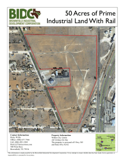
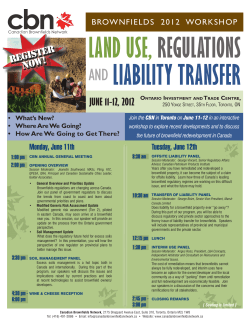


© Copyright 2026