
Frequently Asked Questions (FAQ) METEOROLOGY 6
Frequently Asked Questions (FAQ) 6 METEOROLOGY METEOROLOGY SYNOPTIC METEOROLOGY DYNAMIC METEOROLOGY PHYSICAL METEOROLOGY AGRICULTURE METEOROLOGY APPLIED METEOROLOGY CLIMATOLOGY W HAT IS THE DIFFERENCE BETWEEN WEATHER AND CLIMATE? HOW FAR AHEAD CAN WE PREDICT THE WEATHER AND CLIMATE THESE DAYS? 6 6 6 6 7 7 7 7 7 8 FORECASTING TERMS W HAT IS FORECASTING? W HAT IS NOW CASTING? W HAT IS SHORT RANGE WEATHER FORECASTING? W HAT ARE MEDIUM RANGE FORECASTS? W HAT IS LONG RANGE FORECAST? 8 8 8 8 8 8 SEASONS W HAT ARE THE SEASONS DEFINED BY THE INDIA METEOROLOGICAL DEPARTMENT? W HAT IS MONSOON? W HAT IS NORTHEAST MONSOON? W HAT IS SOUTHWEST MONSOON? W HAT ARE THE DIFFERENT METHODS USED FOR LONG RANGE FORECASTING? W HAT IS THE BASIC PREMISE OF LRF? W HAT ARE EL NIÑO AND LA NIÑA? W HAT IS SO, EL NINO, LA NINA AND ENSO? W HAT IS THE RELATIONSHIP BETWEEN MONSOON AND ENSO? W HETHER SKILLFUL QUANTITATIVE LONG RANGE FORECASTS CAN BE ISSUED FOR SMALLER SPATIAL (FOR DISTRICTS, STATES ETC.) AND TEMPORAL (MONTHLY, BIMONTHLY ETC.) SCALES USING STATISTICAL MODELS? HOW DO THE INDIAN METEOROLOGISTS DESCRIBE MONSOON ACTIVITY? W HAT IS ONSET & ADVANCE OF MONSOON? 8 9 9 9 9 10 10 10 11 11 11 12 14 DROUGHT W HAT IS DROUGHT? W HAT ARE THE DIFFERENT TYPES OF DROUGHT? DEFINING AND MONITORING METEOROLOGICAL DROUGHT W HAT IS HYDROLOGICAL DROUGHT? W HAT IS AGRICULTURAL DROUGHT? HOW SOCIO-ECONOMIC DROUGHT IS DEFINED? HOW INDIA METEOROLOGICAL DEPARTMENT DECLARES A YEAR AS A DROUGHT YEAR? W HAT ARE THE ENVIRONMENTAL IMPACTS OF DROUGHT? W HAT ARE THE SOCIETAL IMPACTS OF DROUGHT? FACTORS AGGRAVATING DROUGHT IMPACTS HOW INDIA METEOROLOGICAL DEPARTMENT MONITORS AGRICULTURAL DROUGHT? 1 14 14 15 15 15 15 15 15 15 16 16 16 WEATHER PHENOMENA W HAT IS DEW? W HAT IS A NOR'WESTER? W HAT IS THUNDERSTORM? W HAT IS A DUST STORM? W HAT IS SQUALL? W HAT IS TORNADO? HOW LONG IS A TORNADO USUALLY ON THE GROUND? W HAT ARE W ALL CLOUDS? DO TORNADOES ALWAYS COME FROM A WALL CLOUD? SCALE TO MEASURE THE INTENSITY OF TORNADO? W HAT IS AVERAGE SPEED OF MOVEMENT OF TORNADO? W HAT DOES A TORNADO SOUND LIKE? DIFFERENCE BETWEEN TORNADOES AND FUNNEL CLOUDS W HICH IS STRONGER, A HURRICANE OR TORNADO? W HAT ARE COLD AIR FUNNEL CLOUDS? W HAT ARE LANDSPOUTS? W HAT ARE W ATERSPOUTS? W HAT ARE GUSTNADOES? W HAT ARE STRAIGHT LINE WINDS? W HAT ARE DUST DEVILS? W HAT IS HAIL? W HAT IS GRAUPEL ? DIFFERENCE BETWEEN GRAUPEL AND HAIL W HAT IS BLIZZARD? W HAT IS HEAT WAVE? W HAT IS COLD WAVE? W HAT IS HOT DAY? W HAT IS EASTERLY WAVE? W HAT IS FOG? W HAT IS THUNDER? W HAT CAUSES THUNDER? W HY ARE SEVERE THUNDERSTORMS SO DANGEROUS? DO ALL THUNDERSTORMS HAVE HAIL? W HAT IS LOW PRESSURE AREA? W HAT IS A TROPICAL CYCLONE? W HY DO 'TROPICAL CYCLONES' WINDS ROTATE COUNTER-CLOCKWISE (CLOCKWISE) IN THE NORTHERN (SOUTHERN) HEMISPHERE? W HAT DOES "MAXIMUM SUSTAINED WIND" MEAN? HOW DOES IT RELATE TO GUSTS IN TROPICAL CYCLONES? W HAT IS THE WIND STRUCTURE IN A CYCLONE? W HICH ARE THE LARGEST AND SMALLEST TROPICAL CYCLONES ON RECORD? W HAT IS DVORAK TECHNIQUE? W HAT DO MEAN BY T NUMBER OF CYCLONIC STORM. W HAT IS TERMINOLOGY USED IN THE CYCLONE WARNING BULLETINS FOR SEA CONDITION? W HO IS RESPONSIBLE FOR ISSUING OPERATIONAL LONG RANGE FORECAST IN INDIA? W HAT METHOD IS USED FOR THE PURPOSE? W HICH ARE THE COUNTRIES THAT USE EMPIRICAL MODELS FOR LONG RANGE FORECASTS? W HAT ARE THE LONG RANGE FORECASTS PREPARED BY IMD AND WHEN ARE THEY ISSUED. W HAT IS THE ACCURACY OF THE LONG RANGE FORECAST FOR MONSOON RAINFALL ISSUED BY IMD? W HAT IS THE NEED OF LONG RANGE FORECAST OF SOUTHWEST MONSOON RAINFALL? W HO ARE THE MAIN USERS OF THE LONG RANGE FORECASTS? W HAT ARE THE COLD WAVE CONDITIONS FOR COASTAL STATIONS? 2 16 17 17 17 17 17 18 18 18 18 18 18 18 19 19 19 19 20 20 20 21 21 21 21 21 22 22 23 23 23 23 23 24 24 24 24 25 25 25 26 26 26 27 27 27 27 28 28 29 W HAT IS THE CRITERIA FOR DESCRIBING COLD DAY FOR COASTAL STATIONS? 29 29 THERMODYNAMIC PARAMETERS W HAT IS TEMPERATURE? W HAT IS THE DEW POINT? W HAT IS FREEZING LEVEL? W HAT IS ADIABATIC LAPSE RATE? W HAT IS PSEUDO LAPSE RATE? W HAT IS CONDENSATION? W HAT IS CONVECTION? W HAT IS LATENT HEAT? HOW IS IT IMPORTANT IN METEOROLOGY? W HAT IS POTENTIAL TEMPERATURE? W HAT IS LIFTED CONDENSATION LEVEL (LCL)? 29 29 30 30 30 30 30 30 30 31 32 ATMOSPHERIC ELECTRICITY W HAT IS LIGHTNING W HAT TYPE OF ELECTRICITY IS LIGHTNING? HOW MANY VOLTS AND WATTS ARE IN LIGHTNING? HOW HOT CAN LIGHTNING MAKE THE AIR? 32 33 33 33 TYPES OF PRECIPITATION, CHARACTERISTIC AND THEIR MEASUREMENT HOW DO WE EXPRESS THE QUANTITY OF RAINFALL? HOW IS RAIN MEASURED? HOW DO WE EXPRESS THE QUANTITY OF RAINFALL? HOW IS SNOW MEASURED? W HAT IS SHOWER? HOW DO YOU CALCULATE THE WATER EQUIVALENT OF SNOW? W HAT IS WIND CHILL? W HAT IS THE WIND CHILL INDEX? W HAT IS THE "RELATIVE HUMIDITY"? W HAT IS THE "HUMIDEX"? HOW IS THE HUMIDEX CALCULATED? 33 33 33 33 34 34 34 34 35 35 35 36 ATMOSPHERE W HAT IS ATMOSPHERE OF EARTH ? HOW IS EARTH ATMOSPHERE DIVIDED? W HAT IS ENVIRONMENTAL SCIENCE? W HAT IS MEANT BY TROPOSPHERE? W HICH LEVELS OF THE ATMOSPHERE ARE DENOTED BY LOWER, MIDDLE AND UPPER TROPOSPHERIC LEVELS? W HAT IS OZONE? W HERE IS OZONE FOUND? HOW IS STRATOSPHERIC OZONE FORMED? W HY IS THE OZONE LAYER IMPORTANT? IS THE OZONE LAYER EVENLY DISTRIBUTED AROUND THE EARTH? W HAT IS ULTRAVIOLET RADIATION? HOW HARMFUL IS UV? W HAT IS THE ULTRA VIOLET (UV) INDEX? W HERE CAN I FIND INFORMATION ON IT? DO FACTORS OTHER THAN STRATOSPHERIC OZONE AFFECT THE AMOUNT OF UV RADIATION THAT REACHES THE EARTH? W HAT IS OZONE DEPLETION? HOW LONG HAS OZONE DEPLETION BEEN OCCURRING? HOW MUCH OF THE OZONE LAYER HAS BEEN DEPLETED AROUND THE WORLD? 3 36 36 37 37 37 37 38 38 38 38 38 39 39 40 40 40 41 W HAT HUMAN ACTIVITIES CAUSE OZONE DEPLETION? W HY ARE INDUSTRIAL HALOCARBONS SO EFFECTIVE AT DESTROYING OZONE? W HO BROKE THE CRITICAL STRUCTURE OF OZONE ? W HAT IS THE OZONE HOLE? W HAT ARE THE MOST WIDELY USED OZONE-DEPLETING HALOCARBONS? W HAT TYPE OF DAMAGE CAN THEY DO? 41 41 41 41 41 42 43 MISCELLANEOUS W HAT ARE CLOUDS AND HOW THEY ARE CLASSIFIED? HOW DO WE DESCRIBE THE SKY CONDITIONS ON PARTICULAR DAY/TIME? HOW BIG CAN SNOWFLAKES GET? W HY IS SNOW WHITE? W HAT CAUSES THE BLUE COLOR THAT SOMETIMES APPEARS IN SNOW AND ICE? IS IT EVER TOO COLD TO SNOW? W HEN IS IT TOO WARM TO SNOW? HOW DOES SNOW FORM IF THE GROUND TEMPERATURE IS ABOVE FREEZING? W HY CAN SNOW FALL WHEN TEMPERATURES ARE ABOVE FREEZING? DOES SNOW ALWAYS GET FLUFFIER AS TEMPERATURES GET COLDER? IS IT TRUE THAT THERE IS ONE INCH OF WATER IN EVERY TEN INCHES OF SNOW THAT FALLS? W HY IS SNOW A GOOD INSULATOR? IS SNOW EDIBLE? W HY IS SNOW COLDER IN DEEPER SPOTS? W HY IS SNOW DEEP IN SPOTS AND NOT OTHERS? W HY DO MORE ICICLES FORM ON THE SOUTH SIDES OF BUILDINGS? W HY DO WEATHER FORECASTERS SEEM TO HAVE SO MUCH TROUBLE FORECASTING SNOW? IS SNOW A MINERAL? W HAT IS LAKE EFFECT SNOW? W HAT IS THE PROBABILITY OF PRECIPITATION OR POP? W HAT IS THE DIFFERENCE BETWEEN UTC AND GMT? W HAT CAUSES LIGHTNING TO BE COLOURED RATHER THAN THE USUAL WHITE OR BLUE? W HAT ARE CLOUD FLASHES? HOW DOES THE EARTH BENEFIT FROM LIGHTNING? W HAT HAPPENS TO THE GROUND WHEN LIGHTNING STRIKES IT? CAN LIGHTNING STRIKE THE SAME PLACE TWICE? W HAT IS A "STEPPED LEADER?" IS IT POSSIBLE TO HAVE LIGHTNING WITHOUT THUNDER? W HAT IS IT CALLED WHEN LIGHTNING STRIKES SAND AND MELTS IT, FORMING A TUBE? IS LIGHTNING ALWAYS PRODUCED BY A THUNDERSTORM? DOES LIGHTNING ALWAYS STRIKE THE TALLEST OBJECT? W HY ARE WEATHER FORECASTS SOMETIMES INACCURATE? W HAT IS THE DIFFERENCE BETWEEN CLIMATE CHANGE AND CLIMATE VARIABILITY? HOW IS CLIMATE CHANGE LIKELY TO AFFECT THE AVAILABILITY OF WATER RESOURCES? W HAT IS A SATELLITE? W HAT IS SATELLITE METEOROLOGY? W HAT IS SATELLITE ORBIT ? GEOSTATIONARY ORBIT ? W HAT IS POLAR ORBITING SATELLITE? W HAT DO IR AND VIS MEAN? W HAT DO WE SEE ON IR AND VIS IMAGES? W HAT IS A RADAR? W HAT IS THE WORKING PRINCIPLE OF RADARS? W HAT IS DOPPLER PRINCIPLE? HOW DO DOPPLER RADARS MEASURE TARGET VELOCITY? 4 43 43 43 43 44 44 44 44 45 45 45 45 45 45 46 46 46 46 46 47 47 47 47 48 48 48 48 48 48 49 49 49 49 50 50 50 50 50 51 51 51 51 52 HOW MANY DIFFERENT TYPES OF RADAR ARE BEING OPERATED CURRENTLY IN IMD‘S RADAR NETWORK? W HAT IS MAXIMUM TEMPERATURE? W HAT IS MINIMUM TEMPERATURE? W HAT IS ATMOSPHERIC PRESSURE? W HAT IS THE PRESSURE TENDENCY? WIND W HAT IS A SHEAR LINE? W HAT IS A RIDGE? W HAT IS MEANT BY A HIGH/HIGH PRESSURE AREA? W HAT IS A WIND DISCONTINUITY? W HAT IS A GCM - GENERAL CIRCULATION MODEL? HOW ONE CAN DIFFERENTIATE BETWEEN GALES, SQUALL WINDS AND GUST WINDS? HOW THE AIR MOVES? W HY IS WIND CHILL NOT ALWAYS INDICATED IN THE CURRENT CONDITIONS OR IN THE FORECAST? W HAT IS JET STREAM? I'M FAMILIAR WITH MILLIBARS (MBAR). W HAT'S AN HPA (HECTOPASCAL)? W HAT'S A KPA (KILOPASCAL)? I HAVE AN OLD BAROMETER THAT GIVES READINGS THAT RANGE FROM APPROXIMATELY 28 TO 31. ARE THESE INCHES OF MERCURY (HG)? W HAT IS THE FACTOR TO CONVERT KILOPASCALS (KPA) OR HECTOPASCALS (HPA) INTO INCHES OF HG? W HAT DOES THE TERM "KNOT" WHICH IS USED IN MARINE WEATHER FORECASTS MEAN AND HOW DOES IT RELATE TO WIND? W HAT DO YOU MEAN BY THE TERMS LIKE ‗WIDESPREAD‘, ‗ISOLATED‘ ETC, WHILE DESCRIBING THE RAINFALL DISTRIBUTION OVER A REGION? W HAT ARE THE VARIOUS CLASSIFICATIONS OF RAINFALL INTENSITY? HOW DO WE DESCRIBE THE DAY-TO-DAY TEMPERATURE ABERRATIONS, IN METEOROLOGICAL PARLANCE? W HAT IS VISIBILITY? W HAT IS RUNWAY VISUAL RANGE (RVR)? W HAT IS A CYCLONIC CIRCULATION? W HAT IS AN ANTICYCLONE? W HAT ARE THE METEOROLOGICAL TERMINOLOGIES USED TO DESCRIBE LOW PRESSURE W HAT IS MEANT BY A LOCAL FORECAST? W HAT DO YOU MEAN BY TERMS LIKE ONE OR TWO SPELLS, A FEW SPELLS ETC, IN YOUR FORECASTS? W HAT DO VARIOUS TERMS LIKE DRIZZLE, RAIN, SHOWER ETC, MEAN? HOW THESE ARE DIFFERENTIATED? HOW DO WE DIFFERENTIATE BETWEEN MIST, DEW, FOG, FROST , HAZE ETC, BECAUSE ALL ARE RELATED TO WATER DROPLETS, IN VARIOUS MANIFESTATIONS? W HAT DO YOU MEAN BY SQUALLY WEATHER? W HAT ARE TIDAL WAVES? W HAT IS A STORM SURGE? W HAT ARE SWELL WAVES? W HAT ARE THE VARIOUS ISO TERMS IN METEOROLOGY VIZ., ISOBAR, ISOHYET ETC MEAN? W HAT ARE LAND AND SEA BREEZES? I WOULD LIKE TO KNOW WHY DO HIGH PRESSURE SYSTEMS MOVE FASTER THAN LOW PRESSURE SYSTEMS? CAN TORNADOES BE PREDICTED? W HAT IS BATHYMETRY? NOMENCLATURE FOR DIFFERENT PARTS OF THE DAY ? W HAT IS W EEKLY/SEASONAL RAINFALL DISTRIBUTION ON REGIONAL SCALE ? W HAT IS RAINFALL DISTRIBUTION ON ALL INDIA SCALE? W HAT IS SQUALLY WEATHER? W HAT IS FLOOD? W HAT IS FLASH FLOOD? W HAT DO TERMS SUCH AS "NORMAL" OR "ABOVE NORMAL‖ OR ―BELOW NORMAL" MEAN? 5 52 52 52 53 53 53 53 53 53 53 54 54 54 55 55 55 55 56 56 56 57 57 57 57 57 58 59 59 59 60 60 60 60 61 61 61 61 62 62 62 62 63 63 63 64 64 METEOROLOGY Meteorology Meteorology is the science of weather. It is essentially an inter-disciplinary science because the atmosphere, land and ocean constitute an integrated system. The three basic aspects of meteorology are observation, understanding and prediction of weather. There are many kinds of routine meteorological observations. Some of them are made with simple instruments like the thermometer for measuring temperature or the anemometer for recording wind speed. The observing techniques have become increasingly complex in recent years and satellites have now made it possible to monitor the weather globally. Countries around the world exchange the weather observations through fast telecommunications channels. These are plotted on weather charts and analysed by professional meteorologists at forecasting centres. Weather forecasts are then made with the help of modern computers and supercomputers. Weather information and forecasts are of vital importance to many activities like agriculture, aviation, shipping, fisheries, tourism, defence, industrial projects, water management and disaster mitigation. Recent advances in satellite and computer technology have led to significant progress in meteorology. Our knowledge of the weather is, however, still incomplete. Synoptic Meteorology Weather observations, taken on the ground or on ships, and in the upper atmosphere with the help of balloon soundings, represent the state of the atmosphere at a given time. When the data are plotted on a weather map, we get a synoptic view of the world‘s weather. Hence day-to-day analysis and forecasting of weather has come to be known as synoptic meteorology. It is the study of the movement of low pressure areas, air masses, fronts, and other weather systems like depressions and tropical cyclones Dynamic Meteorology This particular branch of meteorology attempts to describe the atmospheric processes through mathematical equations which together are called a numerical model. After defining the initial state of the atmosphere and ocean, the equations are solved to derive a final state, thus enabling a weather prediction to be made. Dynamic meteorology deals with a wide range of hydrodynamical equations from a global scale to small turbulent eddies. The process of solving the equations is very complicated and requires powerful computers to accomplish. Physical Meteorology In physical meteorology we study the physical processes of the atmosphere, such as solar radiation, its absorption and scattering in the earth-atmosphere system, the radiation back to space and the transformation of solar energy into kinetic energy of air. Cloud physics and the study of rain processes are a part of physical meteorology. 6 Agriculture Meteorology In simple terms, agricultural meteorology is the application of meteorological information and data for the enhancement of crop yields and reduction of crop losses because of adverse weather. This has linkages with forestry, horticulture and animal husbandry. The agrometeorologist requires not only a sound knowledge of meteorology, but also of agronomy, plant physiology and plant and animal pathology, in addition to common agricultural practices. This branch of meteorology is of particular relevance to India because of the high dependence of our agriculture on monsoon rainfall which has its own vagaries. Applied Meteorology Like agriculture, there are many human activities which are affected by weather and for which meteorologists can provide valuable inputs. Applied meteorologists use weather information and adopt the findings of theoretical research to suit a specific application; for example, design of aircraft, control of air pollution, architectural design, urban planning, exploitation of solar and wind energy, air-conditioning, development of tourism, etc. Climatology Climatology is a study of the climate of a place or region on the basis of weather records accumulated over long periods of time. The average values of meteorological parameters derived from a data base that extends over several decades are called climatological normals. Different regions of the world have different characteristic climates. However, it is now recognized that climate is not static and issues such as climate change and global warming are receiving increasing attention. What is the difference between weather and climate? Climate, in a narrow sense, can be defined as the average weather conditions for a particular location and period of time. In a wider sense, it is the state of the climate system . Climate can be described in terms of statistical descriptions of the central tendencies and variability of relevant elements such as temperature, precipitation, atmospheric pressure, humidity and winds or through combinations of elements, such as weather types and phenomena that are typical to a location, region or the world for any period of time. How far ahead can we predict the weather and climate these days? Five-day weather forecast today is generally as reliable as a three-day forecast two decades ago. Outlooks of up to a week, especially in temperate mid-latitude regions are becoming increasingly reliable. Information can be disseminated around the world from one location to another within three hours, while recently understood phenomena such as El Niño Southern Oscillation (ENSO) (El Niño, La Niña and neutral phases) can be forecast up to a year in advance. Seasonal climate predictions can be forecast up to a month, three months or six months ahead 7 although these climate predictions are probabilistic in nature. Such forecasts, often from advanced centres, are made available globally to all nations. FORECASTING TERMS What is Forecasting? A. In science, the forecasting means the process of estimation of the value of some variable at some future time. One of the primary functions of the national Weather services is forecast of weather parameters such as rainfall, temperature, wind, humidity etc. over a region averaged over a particular time period. For example forecast of daily rainfall (rainfall averaged over a day). What is now casting? A weather forecast in which the details about the current weather and forecasts up to a few hours ahead (but less than 24 hours) are given. What is short range weather forecasting? Short range weather forecasts are weather forecasts valid up to 72 hours ahead. This forecast range is mainly concerned with the eather systems observed in the latest weather charts and also by considering the generation of new systems within the time period. What are medium range forecasts? These are weather forecasts valid for a period of 4 to 10 days. In this, the average weather conditions and the weather on each day will be prescribed with progressively lesser details and accuracy than that of the short range forecasts. What is long range forecast? As per the World Meteorological Organization (WMO) definition, long range forecast is defined as the forecast from 30 days‘ up to one season‘s description of averaged weather parameters. The monthly and seasonal forecast comes under long range forecast. SEASONS What are the seasons defined by the India Meteorological Department? Meteorological seasons over India are: Winter Season: January – February Pre Monsoon Season: March – May Southwest Monsoon Season: June - September Post Monsoon Season: October - December 8 What is monsoon? The seasonal reversal of winds and the associated rainfall is called monsoon. This word is derived from the Arabic word “Mausim”. The annual oscillation in the apparent position of the Sun between the Tropics of Cancer and Capricorn causes the annual oscillation in the position of the thermal equator (region of maximum heating) on the Earth‘s surface. This is associated with the annual oscillation of temperature, pressure, wind, cloudiness, rain etc. This is the cause of the monsoons. What is northeast monsoon? Northeast monsoon season (post monsoon season). The large indentation made by the Bay of Bengal into India's eastern coast means that the flows are humidified before reaching Cape Comorin and rest of Tamil Nadu, meaning that the state, and also some parts of Kerala, experience significant precipitation in the post-monsoon and winter periods. However, parts of West Bengal, Orissa, Andhra Pradesh, Karnataka and North-East India also receive minor precipitation from the northeast monsoon What is southwest monsoon? The annual oscillation in the apparent position of the Sun between the Tropics of Cancer and Capricorn causes the annual oscillation in the position of the thermal equator (region of maximum heating) on the Earth‘s surface. This is associated with the annual oscillation of temperature, pressure, wind, cloudiness, rain etc. This is the cause of the monsoons. On the Earth‘s surface, there are asymmetries of land and Ocean. The differential heating of land and Ocean cause variations in the intensity of the annual oscillation of the thermal equator and hence regional variations in the intensity of monsoon. The southwesterly wind flow occurring over most parts of India and Indian Seas gives rise to southwest monsoon over India from June to September What are the different methods used for long range forecasting? In general, three approaches are used. These are (i) statistical method (ii) numerical weather prediction or dynamical method and (iii) dynamical cum statistical method. From the beginning, the main approach towards the long range prediction has been based on statistical methods. IMD‘s operational forecasts for the monsoon rainfall are based on this technique. The statistical method involves identification of predictive signals (predictors) that having significant and stable historical relationship with the predict and predicting the value of predict and at future time. For this purpose, it is assumed that the observed predict and-predictor relationship persists in the future also and that the predictor values corresponding to the future predict and value to be forecasted are known. 9 An alternate approach towards the prediction of International School of Management & Research (ISMR) is based on numerical models or so called General Circulation Models (GCM) for the simulation of atmospheric and oceanic conditions. Though the numerical prediction models have the potential for providing predictions over smaller spatial and temporal scales as per the user demands, they have not so far shown required skill for simulating the salient features of the mean monsoon rainfall and its inter-annual variability. For improved rainfall simulations, GCM models should be able to account for local sub grid features and sub-seasonal variability of the climatic fields. The third approach of dynamical cum statistical method is based on the fact that GCMs have better skill in simulating large scale atmospheric circulation features and that there exits a semi empirical relation between rainfall over a region and prevailing large scale circulation features over both global and regional scales. Therefore, it is possible to derive recalibration equations between the rainfall and circulation features simulated by GCM models and assuming that these relationships will hold good in the future, regional rainfall can be predicted. The dynamical cum statistical method is a recent development in the long range prediction. What is the Basic Premise of LRF? The predictability of day-to-day weather patterns in the tropics is restricted to 2-3 days. The seasonal mean monsoon circulation in the tropics, on the other hand, is potentially more predictable. This is because the low frequency component of monsoon variability is primarily forced by slowly varying conditions like sea surface temperature, snow cover, soil moisture etc. Therefore, it is possible to develop models for the long range forecasts of monsoon seasonal rainfall over the country as a whole. However, there is some limit in the seasonal predictability as the mean monsoon circulation is also influenced by the internal dynamics/variability. What are El Niño and La Niña? El Niño, Spanish for "boy child" (because of the tendency of the phenomenon to arrive around Christmas), is an abnormal warming of water in the Equatorial Pacific Ocean every three to five years and can last up to 18 months. Severe cases of El Niño, as in 1997/98, are responsible for drought, flooding, as well as areas of formation for tropical cyclones and severe winter storms. The 1997/98 El Niño and its associated impacts have been blamed for the deaths of hundreds of people and caused billions of dollars of damage in an estimated 15 countries especially in the Panama Canal region but also as far away as the east coast of Africa. La Niña means ―the little girl‖, the opposite of El Niño, and refers to the abnormal cooling of the ocean temperatures in the same Pacific region. What is SO, El Nino, La Nina and ENSO? Southern Oscillation or ―SO‖ is a "see-saw" in the surface air pressure between eastern and western tropical Pacific. It is characterized by simultaneously opposite sea level pressure anomalies at Tahiti, in the eastern tropical Pacific and Darwin, on the northwest coast of Australia. The SO was discovered by Sir Gilbert Walker in the early 1920's. Later, the three-dimensional east-west circulation related to the SO was 10 discovered and named the Walker Circulation. The SO has periodicity of about 2-5 years. A most common index of SO is computed as the difference between standardized sea level pressure anomalies at Tahiti and Darwin (Tahiti – Darwin). El Nino and La Nina are oceanic manifestation of opposite phases of SO, which is an atmospheric phenomena. El Nino is characterized by the warming of the sea surface temperatures in the central and eastern equatorial Pacific Ocean, beginning at about Christmas time (hence the name "El Nino", which is a reference to the Christ child). This is called the warm phase of the SO. The cold phase of the SO, called "La Nina" is characterized by high pressure in the eastern equatorial Pacific, low in the west, and by anomalously cold SST in the central and eastern Pacific. ENSO (El Nino Southern Oscillation) is an acronym designed to stress the fact that the El Nino and SO are components of the same global Ocean-Atmosphere coupled phenomena. What is the relationship between Monsoon and ENSO? Both monsoon and ENSO are ocean-atmosphere couple phenomena. There is a general inverse relationship between monsoon and ENSO. The warm phase of ENSO is generally associated with weaker than normal Monsoon and vice versa. During the period 1885-2007 there were 36 years of warm ENSO (El Nino) and 25 years of cold ENSO (La Nina). During the 15 of the 35 El Nina years (42%), Indian summer monsoon rainfall (ISMR) was below normal and 9 of the 25 La Nina years (36%), ISMR was above normal. This shows that there is no one to one correspondence between ENSO and ISMR. Whether skillful quantitative long range forecasts can be issued for smaller spatial (for districts, states etc.) and temporal (monthly, bimonthly etc.) scales using statistical models? The monsoon system is a planetary scale system, and it has large variability at different spatial and temporal scales. The long range forecasting is mainly used to predict the inter-annual variability of the monsoon rainfall over large region. In addition to the influence of various global and regional factors over the monsoon circulation, the monsoon rainfall over a region depends on the local factors such as geography of the area. As a result, smaller the area we consider, the larger will be the variability of the rainfall over the region. Therefore, it may not be easy to model such a large variability of rainfall with the help of predictors. That is why even during the recent series of successive normal monsoons (1988-2001) over the country as whole drought conditions were prevailing over many parts of the country. How do the Indian Meteorologists describe monsoon activity? Southwest monsoon activity is described using the following terminology, viz., Weak/subdued Monsoon Normal Monsoon Rainfall less than half the normal (over the land area) Wind speed upto 12 knots (over the Sea) Rainfall half to less than 1½ times the normal (over the land area) 11 Active Monsoon Vigorous Monsoon Break Monsoon Wind speed is between13 to 22 knots(over the Sea) i) Rainfall 1 ½ to 4 times the normal. ii) The rainfall in at least two stations should be 5 cm, if that sub-division is along the west coast and 3 cm, if it is else where. iii) Rainfall in that sub-division should be fairly widespread to widespread. (over the land area) Wind speed is between 23 to 32 knots(over the Sea) i) Rainfall more than 4 times the normal. ii) The rainfall in at least two stations should be 8 cm if the sub-division is along the west coast and 5 cm if it is elsewhere. iii) Rainfall in that sub-division should be fairly widespread or widespread. Wind speed is 33 knots and above(over the Sea) Monsoon trough shifts northwards and runs close to foot hills of Himalayas, resulting in drastic reduction in rainfall over the country outside the foot hills and southernmost Peninsula. The northeast monsoon is described using the following terminologies. Weak Monsoon : Normal Monsoon : Active Monsoon : Vigorous Monsoon : Rainfall leRainfall less than half the normal. Rainfall hRainfall is half to less than one and a half (1½) times the normal. i) Rainfall 1½ to 4 times the normal. ii) Rainfall in atleast two stations should be 3 cm in coastal Tamil Nadu and south coastal Andhra Pradesh and 2 cm elsewhere. iii) Rainfall in that sub-division should be fairly widespread or widespread. i) Rainfall exceeding 4 times the normal. ii) Rainfall in atleast two stations should be 5 cm in coastal Tamil Nadu and south coastal Andhra Pradesh and 3 cm elsewhere. iii) Rainfall in that sub-division should be fairly widespread or widespread. What is Onset & Advance of Monsoon? The onset of the broad-scale monsoon occurs in many stages and represents a significant transition in the large-scale atmospheric and ocean circulations in the Indo-Pacific region. As the rainfall continuously occurs at a place is called that monsoon has advanced upto that place. The guidelines to be followed for declaring the onset of monsoon over Kerala and its further advance over the country are enlisted below: 12 a) Rainfall If after 10th May, 60% of the available 14 stations enlisted*, viz. Minicoy, Amini,Thiruvananthapuram, Punalur, Kollam, Allapuzha, Kottayam, Kochi, Thrissur, Kozhikode, Thalassery,Kannur, Kasargode and Mangalore report rainfall of 2.5 mm or more for two consecutive days, the onset over Kerala be declared on the 2nd day, provided the following criteria are also in concurrence. b) Wind field Depth of westerlies should be maintained upto 600 hPa, in the box equator to Lat. 10ºN and Long. 55ºE to 80ºE. The zonal wind speed over the area bounded by Lat. 5-10ºN, Long. 70-80ºE should be of the order of 15 – 20 Kts. at 925 hPa. The source of data can be RSMC wind analysis/satellite derived winds. c). Outgoing Longwave Radiation (OLR) INSAT derived OLR value should be below 200 wm -2 in the box confined by Lat. 510ºN and Long. 70-75ºE. Further Advance of Monsoon over the Country a) Further advance be declared based on the occurrence of rainfall over parts/sectors of the sub-divisions and maintaining the spatial continuity of the northern limit of monsoon, further advance be declared. The following auxiliary features may also be looked into: b) Along the west coast, position of maximum cloud zone, as inferred from the satellite imageries may be taken into account. c) The satellite water vapour imageries may be monitored to assess the extent of moisture incursion. Northern Limit of Monsoon (NLM) Southwest monsoon normally sets in over Kerala around 1 st June. It advances northwards, usually in surges, and covers the entire country around 15 th July. The NLM is the northern most limit of monsoon upto which it has advanced on any given day. Withdrawal of SW Monsoon a) Withdrawal from extreme north-western parts of the country should not be attempted before 1st September. b) After 1st September: The following major synoptic features should be considered for the first withdrawal from the western parts of NW India. 13 i) Cessation of rainfall activity over the area for continuous 5 days. ii) Establishment of anticyclone in the lower troposphere (850 hPa and below) iii) Considerable reduction in moisture content as inferred from satellite water vapour imageries and tephigrams. Further Withdrawal from the Country i) Further withdrawal from the country may be declared, keeping the spatial continuity, reduction in moisture as seen in the water vapour imageries and prevalence of dry weather for 5 days. ii) SW monsoon should be withdrawn from the southern peninsula and hence from the entire country only after 1st October, when the circulation pattern indicates a change over from the southwesterly wind regime. Commencement of NE monsoon rains i) Withdrawal of SW monsoon upto Lat. 15ºN. ii) Onset of persistent surface easterlies over Tamil Nadu coast. iii) Depth of easterlies upto 850 hPa over Tamil Nadu coast. iv) Fairly widespread rainfall over coastal Tamil Nadu, south coastal Andhra Pradesh and adjoining areas. Criteria for Declaring Onset of Northeast Monsoon For declaring onset of Northeast Monsoon following criteria may be considered: (1) Withdrawal of south west Monsoon upto 15º N. (2) Onset of persistent surface easterlies over Tamil Nadu coast. (3) Depth of easterlies upto 850 hPa over Tamil Nadu coast. (4) Fairly widespread rainfall over the coastal Tamil Nadu and adjoining areas. (5) Onset is not to be declared before 10th October even, if the conditions described above exist. DROUGHT What is Drought? Drought is the consequence of a natural reduction in the amount of precipitation over an extended period of time, usually a season or more in length, often associated with other climatic factors (viz. high temperatures, high winds and low relative humidity) that can aggravate the severity of the drought event. What are the different types of drought? Meteorological Drought Hydrological Drought Agricultural Drought Socio-Economic Drought 14 Defining and monitoring Meteorological Drought In India, according to India Meteorological Department, meteorological drought over an area is defined as a situation when the seasonal rainfall received over the area is less than75% of its long term average value. It is further classified as "moderate drought" if the rainfall deficit is between 26-50% and "severe drought" when the deficit exceeds 50% of the normal. What is Hydrological Drought? Hydrological Drought can be defined as a period during which the stream flows are inadequate to supply established use of water under a given water management system. What is Agricultural Drought? It occurs when available soil moisture is inadequate for healthy crop growth and cause extreme stress and wilting. How Socio-Economic Drought is defined? Abnormal water shortage affects all aspects of established economy of a region. This in turn adversely affects the social fabric of the society creating unemployment, migration, discontent and various other problems in the society. Thus, meteorological, hydrological and agricultural drought often lead to what is termed as ‗Socio-economic drought‘. How India Meteorological Department declares a year as a Drought Year? In our country, a year is considered to be a Drought Year in case the area affected by moderate and severe drought, either individually or together, is 20-40% of the total area of the country and seasonal rainfall deficiency during south-west monsoon season for the country as a whole is at least 10% or more. When the spatial coverage of drought is more than 40% it will be called as All India Severe Drought Year. What are the Environmental Impacts of Drought? 1. 2. 3. 4. Moisture Stress Drinking Water Shortage Damage To Natural Vegetation and Various Ecosystems Increased Air And Water Pollution What are the Societal Impacts of Drought? 1. 2. 3. Malnutrition Poor Hygiene Ill Health 15 4. 5. 6. Migration Increased Stress and Morbidity Social Strife Factors Aggravating Drought Impacts Aridity of the Area: Lower Soil Moisture Retention. shortage of farm inputs lack of resources including credit on reasonable terms non-availability of alternate seeds short supply of electric power and diesel oil for ground water pumpsets poor or non-existent medical help for the needy. Programmes to ameliorate drought distress measures to maintain food and fodder supply price support systems employment generation programmes responsive pds for food items and other essential goods safe water and health programmes cheap credit programmes alternate crop programmes fodder banks cattle shelters diet supplement programme for children and expectant and lactating mothers How India Meteorological Department monitors Agricultural Drought? IMD has developed aridity indices to monitor agricultural drought scenario in the country based on rainfall, potential evapotranspiration and actual evapotranspiration using water budgeting method. Agricultural droughts have been classified into mild, moderate and severe based on aridity anomaly index values. Mild (Aridity anomaly 1 – 25%), Moderate (Aridity anomaly 26 – 50%) and Severe (Aridity anomalies more than 50%) WEATHER PHENOMENA What is Dew? The best way to understand the dew point notion is to visualise how dew is formed on a clear fall morning, for example. Dew occurs as a result of the air gradually cooling overnight. In the late afternoon, the air holds a certain quantity of water vapour (humidity). During a clear night, however, the earth's surface loses radiational heat rapidly and cools; consequently, air in contact with the earth's surface is forced to cool while the atmospheric pressure remains the same. After a certain period of 16 cooling off, the air reaches its saturation point and if it cools any further, we witness an excess of humidity that condenses and forms dew. The temperature at which condensation starts occurring is dew point temperature What is a Nor'wester? Nor‘westers are special type of thunderstorms of Gangetic plains of India which are locally known as ―Kalbaisakhi‖. These storms most frequently (move west to east in genera) lcome from the west or north-west towards Kolkata city of West Bengal state of India and hence are called ‗nor‘westers‘. The formation of nor‘westers is attributed to a warm, moist, southerly low-level flow from the Bay of Bengal and an upper-level dry, cool, westerly or north-westerly flow giving rise to an atmosphere with high latent instability. Nor‘westers generally originates over Bihar and Jharkhand state of India and strike West Bengal and Orissa from the north-west. These storms are very severe in nature and cause extensive damage to Public life and properties. What is thunderstorm? A thunderstorm is defined as a meteorological phenomenon in which one or more sudden electrical discharges manifested by a flash of light (Lightning) and a sharp rumbling sound (thunder) occurs from a cloud of vertical development. What is a Dust storm? Duststorm is an ensemble of particles of dust or sand energetically lifted to great heights by a strong and turbulent wind. Often the surface visibility is reduced to low limits; the qualification for a synoptic report is visibility below 1000 m. What is Squall? A squall is a strong, sudden wind which generally lasts a few minutes then quickly decreases in speed. What is tornado? The typical tornado first appears as a rotation in a huge thunder cloud, behind a shroud of heavy rain or hail. The sky usually turns green, yellow or black. The tornado descends as a violently rotating funnel cloud and sounds like the rumble of a freight train or a jet and can be quite deafening. Tornadoes typically snake erratically from southwest to northeast, toppling buildings, scattering debris and tossing cars as though they were toys. A tornado can last just a few minutes or a few hours and usually leaves a wake of destruction. The averages are also deceiving because the majority of twisters do little more than bend TV antennae, break windows, uproot trees, or damage weak structures such as barns and sheds. With wind speeds of less than 160 km/h, and a path 100 m wide by 2 km long, these small tornadoes cause less than three percent of all deaths. 17 The more violent tornadoes are the most devastating storms on earth. With winds approaching 500 km/h, they can level even the most solid structures. The path of destruction can reach over 100 km long and over 1 km wide.. How long is a tornado usually on the ground? Detailed statistics about the time a tornado is on the ground are not available. This time can range from an instant to several hours. The average is about five minutes. What are Wall Clouds? A wall cloud is a portion of a thunderstorm cloud that appears to hang underneath the main cloud base. It is associated with the main updraft of the storm. If the wall cloud persists for more than a few minutes and appears to rotate, it is a sign of a possible tornado, although only about 10-15% of rotating wall clouds generate tornadoes. Do tornadoes always come from a wall cloud? A wall cloud is not always present. It is possible, though, that you cannot see a wall cloud because of your viewing angle. Scale to measure the intensity of Tornado? The Fujita scale measures tornado strength. F0 is the least intense; F5 the most intense. The scale is named for Dr. T. Fujita, a pioneer in tornado research at the University of Chicago. What is average speed of movement of Tornado? A tornado moves over the ground at speeds between 20 and 90 km/h. The path is usually southwest to northeast. The path of a tornado can be erratic and may suddenly change direction. If you see a tornado and it does not appear to be moving, it is either moving straight away or straight toward you. What does a tornado sound like? People who have been in a tornado say it sounds like a jet engine or a freight train and is very loud. They said it hurt their ears but they were more worried about what might happen to them than they were about the pain in their ears. Difference between Tornadoes and Funnel Clouds A tornado is a tightly spinning column of air in contact with the ground beneath a thunderstorm cloud. The rotating column is physically connected to the cloud base or wall cloud and is often visible as a cloud-filled "condensation funnel". If the air is dry enough, the tornado may only appear as a swirl of dirt on the ground without a visible connection to the cloud above. 18 In contrast, a funnel cloud spins in mid-air without touching the ground. To tell the difference between a funnel cloud and a tornado, look for swirling dust or debris near the ground under the funnel. If present, then a tornado is occurring. Most tornadoes and funnel clouds are preceded by and form approximately in the middle of an accompanying rotating wall cloud. The Fujita scale (F0 to F5) is used to rate the severity of tornadoes after they occur by the extent of the damage they cause. The parent storms often are observed by Doppler radar and can be forecasted. Which is stronger, a hurricane or tornado? The winds from a strong tornado (F4 or F5 - 207 mph or higher) are significantly stronger than the highest category of hurricane (Saffir-Simpson Scale Category 4 or 5 - 131 mph and higher). However, hurricanes tend to cause much more destruction than tornadoes because they cover a much larger area, last longer, and have a variety of destructive forces (the eyewall, storm surge, flooding, and sustained strong winds). Tornadoes, in contrast, tend to be a mile or smaller in diameter, last for minutes and primarily cause damage from their extreme winds. What are Cold Air Funnel Clouds? These funnel clouds are spawned by large cumulus clouds or weak thunderstorms. Typically, the days when they occur are a bit cooler than normal with large puffy cumulus clouds, showers or weak thunderstorms developing in the late morning or early afternoon. Since the storms are not very strong or well organized, cold air funnels are usually short-lived and normally do not have the energy to reach the ground. However, a small percentage may touch down briefly and can become destructive over a very small area. In general, they are less violent than most other types of tornadoes. These funnel clouds will normally appear with little or no warning. Meteorologists can predict the days when cold air funnels are likely to occur over a general area. When they are predicted or sighted, a special tornado watch will be issued that outlines the need for caution but recognizes their weak and short-lived nature. What are Landspouts? Landspouts are a form of tornado, it usually have a narrow, rope-like condensation funnel extending from the cloud base to the ground, and are seen under small storms or large, growing cumulus clouds. They are similar to a cold-air funnel that has touched down, and while usually weak and short-lived, they can be potentially dangerous. Like their cold air cousin, landspouts can form from rather nondescript developing cumulus clouds or thunderstorms, often before precipitation is visible on radar. Specific tornado warnings are issued when landspouts are predicted or reported. What are Waterspouts? The waterspout looks like a cylinder tornado but occurs only over water, or the nearby shore, in the same conditions that bring cold-air funnels or landspouts. Cool, unstable air masses passing over warmer waters allow vigorous updrafts to form, which can tighten into a spinning column when captured by a passing 19 thundershower. Waterspouts are just as dangerous on water and shoreline areas as landspouts are on land, but often collapse after moving a few hundred metres inland, away from the warm water. A true waterspout forms over the water and is not accompanied by a strong storm. If conditions are cool and cloudy, with showers but no organized storms, then the appearance of a tornado-like funnel over water can be identified as a waterspout. If a severe storm with a tornado happens to pass over a stretch of water, the tornado is sometimes called a tornadic waterspout and would be just as dangerous as a tornado is over land. What are Gustnadoes? "Gustnadoes" typically appear as a swirl of dust or debris along the "gust front" of a thunderstorm. They are not directly linked with rotation in the thunderstorm itself and can form a considerable distance away from the parent storm. There is no condensation funnel or other visible connection to the cloud base. Gustnadoes account for a large number of the weakest tornado reports each year. Their localized impact and damaging effects have allowed them to be counted as tornadoes but most are probably not "true" tornadoes. The strong, straight line winds that can follow behind the gustnadoes are likely to cause more damage than the gustnadoes themselves. Gustnadoes are not visible on Doppler radar. Meteorologists do not forecast gustnadoes, but can issue Severe Thunderstorm Warnings for the gust fronts of stronger storms that are detectable on Doppler radar. What are Straight Line Winds? A "plough" wind is a strong, straight-line wind associated with downdrafts that spread out ahead of isolated thunderstorms or small clusters of thunderstorms. These winds push across the ground like a blade in front of a snowplow or bulldozer, damaging susceptible objects and scattering the debris. The damage caused is often mistakenly attributed to a tornado. The wind may roar as it passes by. Damage can be heavy and confined to narrow zones like that caused by tornadoes. Plough winds (and the damage they cause) are all in one general direction, rather than rotating as in a tornado. A plough wind is termed "severe" if it exceeds 90 km/h. "Derechos" are areas of greater wind damage associated with clusters of intense thunderstorms or lines of closely-spaced thunderstorms. They are longer-lived and more intense than plough winds. What are Dust Devils? On sunny, dry days, heated air near the ground can rise in small, spinning columns. If these columns occur over dusty ground, a dust devil may be observable. The stronger ones become visible when loose grass, hay or dust gathers into the whirl and rises up the column. These dust devils can look like a weak tornado at the bottom but rarely extend higher than 100 metres. They are only seen in fair weather sometimes without a cloud in the sky. Larger dust devils can extend hundreds of metres high, toss lawn furniture and lift objects weighing a hundred kilograms, but are generally not a threat otherwise. Dust devils near a highway deserve caution as vehicles passing through them can be difficult to control. Like other weak circulations, meteorologists can tell which days and general areas are most likely to 20 have dust devils, but they cannot be forecast and are not observable on Doppler radar. Severe Weather Warnings are not usually issued for dust devils. What is Hail? It is solid precipitation in the form of balls or pieces of ice (hailstones) with diameters ranging from 5 to 50 mm or even more. Hail can be extremely dangerous and can cause extensive damage in only a few minutes. To avoid or minimize personal injury or property damage: Move vulnerable items such as cars, equipment and machinery to shelter when a storm threatens, provided such action does not pose a personal risk. If caught outside, reduce chances of injury to yourself by crouching down and protecting your head and neck as much as possible. Protect pets & livestock. Many are injured each year by hail. Ensure that they have shelter available. While hail may or may not precede a tornado, large hail often appears near the area within a thunderstorm where tornadoes are most likely to form. Once large hail starts to fall, it is safer to assume that a tornado could be nearby and to seek appropriate shelter. Once the hail has stopped, remain in a protected area until the storm has passed, usually 15 to 30 minutes after the hail stops. What is Graupel ? Graupel forms when snow in the atmosphere encounters supercooled water. In a process known as accretion, ice crystals form instantly on the outside of the snow and accumulate until the original snowflake is no longer visible or distinguishable. The coating of these ice crystals on the outside of the snow is called a rime coating. The size of graupel is typically under 5 millimeters, but some graupel can be the size of a quarter (coin). Difference between graupel and hail Difference between graupel and hail, touch a graupel ball. Graupel pellets typically fall apart when touched or when they hit the ground. Hail is formed when layers of ice accumulate and are very hard as a result. What is blizzard? A blizzard is a severe storm condition characterized by low temperatures, strong winds, and heavy snow. The difference between blizzard and a snowstorm is the strength of the wind. Ground blizzards are a variation on the traditional blizzard, in that ground blizzards require high winds to stir up snow that has already fallen, rather than fresh snowfall. Regardless of the variety of blizzard, they can bring nearwhiteout conditions, which restrict visibility to near zero. Blizzards have a negative impact on local economies and for days at a time can paralyze regions where snowfall is unusual or rare. What is heat wave? A. continuous spell of abnormally hot weather 21 Heat wave need not be considered till maximum temperature of a station reaches at least 40º C for Plains and at least 30º C for Hilly regions. a) When normal maximum temperature of a station is less than or equal to 40º C Heat Wave Departure from normal is 5º C to 6º C Severe Heat Wave Departure from normal is 7º C or more b) When normal maximum temperature of a station is more than 40º C Heat Wave Departure from normal is 4º C to 5º C Severe Heat Wave Departure from normal is 6º C or more c) When actual maximum temperature remains 45ºC or more irrespective of normal maximum temperature, heat wave should be declared. What is cold wave? A rapid fall in temperature within 24 hours to a level requiring substantially increased protection to agriculture, industry, commerce, and social activities. a) When normal minimum temperature is equal to 10°C or more. Cold Wave Departure from normal is -5°C to -6°C. Severe Cold Wave Departure from normal is -7°C or less b) When normal minimum temperature is less than 10°C. Cold Wave Departure from normal is -4°C to -5°C. Severe Cold Wave Departure from normal is -6°C or less. When WCTn is 0°C or less, Cold Wave should be declared irrespective of normal minimum temperature of the station. However, this criteria is not applicable for those stations whose normal minimum temperature is below 0°C. What is hot day? In the northern plains of the country, dust in suspension occurs in many years for several days, bringing minimum temperature much higher than normal and keeping the maximum temperature around or slightly above normal. Sometimes increase in humidity also adds to this discomfort. Nights do not get cooled and become uncomfortable. To cover this situation, hot day concept has been introduced as given below: Whenever, the maximum temperature remains 40ºC or more and minimum temperature is 5º C or more above normal 22 What is easterly wave? A shallow trough disturbance in the easterly current of the tropics, more in evidence in the upper level winds than in surface pressure, whose passage westwards is followed by a marked intensification of cloudy, showery weather. The southern peninsular region is affected by easterly waves. What is fog? Fog is a phenomenon of small droplets suspended in air and the horizontal visibility is one kilometer or less. What is thunder? Thunder is the noise caused by the explosive expansion of air due to the heat generated by a lightning discharge. Thunder may have a sharp cracking sound when lightning is close by, compared to a rumbling noise produced by more distant strokes. Because light travels at a faster speed than sound, you can see a lightning bolt before the sound of thunder reaches you. To judge how close lightning is, count the seconds between the flash and the thunder clap. Each second represents about 300 metres. If you can count less than 30 seconds between the lightning strike and the thunder, the storm is less than 10 km away and there is an 80 percent chance the next strike will happen within that 10 km. If you count less than 30 seconds, take shelter, preferably in a house or allmetal automobile (not a convertible top) or in a low-lying area. Lightning may strike several kilometres away from the parent cloud and precautions should be taken even if the thunderstorm is not directly overhead. What causes thunder? Thunder is caused by lightning. The bright light of the lightning flash caused by the return stroke mentioned above represents a great deal of energy. This energy heats the air in the channel to above 50,000 degrees F in only a few millionths of a second! The air that is now heated to such a high temperature had no time to expand, so it is now at a very high pressure. The high pressure air then expands outward into the surrounding air compressing it and causing a disturbance that propagates in all directions away from the stroke. The disturbance is a shock wave for the first 10 yards, after which it becomes an ordinary sound wave, or thunder. Thunder can seem like it goes on and on because each point along the channel produces a shock wave and sound wave Why are severe thunderstorms so dangerous? Many hazardous weather events are associated with thunderstorms. Fortunately, the area affected by any one of them is fairly small and, most of the time, the damage is fairly light. Lightning is responsible for many fires around the world each year, as well 23 as causing deaths when people are struck. Under the right conditions, rainfall from thunderstorms causes flash flooding, which can change small creeks into dangerous raging water in a matter of minutes, washing away large boulders and most manmade structures. Hail up to the size of softballs damages cars and windows, and kills wildlife caught out in the open. Strong (up to more than 120 mph) straight-line winds associated with thunderstorms knock down trees and power lines. Tornadoes (with winds up to about 300 mph) can destroy all but the best-built man-made structures. Do all thunderstorms have hail? Most thunderstorms have hail, but not all thunderstorms produce hail at the ground. Temperatures at the upper levels of a thunderstorm are well below freezing level, allowing for the development of hail, but sometimes it melts before reaching the surface of the earth. What is low pressure area? Area in the atmosphere in which the pressures are lower than those of the surrounding region at the same level and is represented on a synoptic chart by a system of one closed isobar (wind speed on the surface < 17 Knots (Kts) when the system is at sea or one closed isobar in the radius of 3 Deg. from the centre over land). What is a tropical cyclone? A tropical cyclone is a rotational low pressure system in tropics when the central pressure falls by 5 to 6 hPa from the surrounding and maximum sustained wind speed reaches 34 knots (about 62 kmph). It is a vast violent whirl of 150 to 800 km, spiraling around a centre and progressing along the surface of the sea at a rate of 300 to 500 km a day. The word cyclone has been derived from Greek word ‗cyclos‘ which means ‗coiling of a snake‘. The word cyclone was coined by Heary Piddington who worked as a Rapporteur in Kolkata during British rule. The terms "hurricane" and "typhoon" are region specific names for a strong "tropical cyclone". Tropical cyclones are called ―Hurricanes‖ over the Atlantic Ocean and ―Typhoons‖ over the Pacific Ocean. Why do 'tropical cyclones' winds rotate counter-clockwise (clockwise) in the Northern (Southern) Hemisphere? As the earth's rotation sets up an apparent force (called the Coriolis force) that pulls the winds to the right in the Northern Hemisphere (and to the left in the Southern Hemisphere). So, when a low pressure starts to form over north of the equator, the surface winds will flow inward trying to fill in the low and will be deflected to the right and a counter-clockwise rotation will be initiated. The opposite (a deflection to the left and a clockwise rotation) will occur south of the equator. This Coriolis force is too tiny to effect rotation in, for example, water that is going down the drains of sinks and toilets. The rotation in those will be determined 24 by the geometry of the container and the original motion of the water. Thus, one can find both clockwise and counter-clockwise flowing drains no matter what hemisphere you are located. If you don't believe this, test it out for yourself. What does "maximum sustained wind" mean? How does it relate to gusts in tropical cyclones? India Meteorological Department (IMD) uses a 3 minutes averaging for the sustained wind. The maximum sustained wind mentioned in the bulletins used by IMD is the highest 3 minutes surface wind occurring within the circulation of the system. These surface winds are observed (or, more often, estimated) at the standard meteorological height of 10 m (33 ft) in an unobstructed exposure (i.e., not blocked by buildings or trees). The National Hurricane Centre uses a 1 minute averaging time for reporting the sustained wind. Some countries also use 10 minutes averaging time for this purpose. While one can utilize a simple ratio to convert from peak 10 minute wind to peak 1 minute wind or 3 minute wind, such systematic differences to make interbasin comparison of tropical cyclones around the world is problematic. However there is no significant difference between the maximum sustained wind reported in different basis with different averaging method. What is the wind structure in a cyclone? The ideal wind and cloud distribution in a cyclone is shown in the following figure. The band of maximum winds may vary between 10 and 150 Km. In this belt, speed decreases rapidly towards the eye of the cyclone. But it decreases slowly and in an irregular fashion outward from the eye wall. Which are the largest and smallest tropical cyclones on record? Typhoon Tip had gale force winds 34 knots (17 m/s), which extended out for 1100 km in radius in the Northwest Pacific on 12 October, 1979. Tropical Cyclone Tracy had gale force winds that only extended 50 km radius when it struck Darwin, Australia, on 24 December, 1974. Considering north Indian Ocean, Orissa super cyclone of October, 1999 and the cyclone, ‗Ogni‘ were the largest and smallest cyclones during 1891-2007. 25 What is Dvorak Technique? The Dvorak technique is a method using enhanced Infrared and/or visible satellite imagery to quantitatively estimate the intensity of a tropical system. Cloud patterns in satellite imagery normally show an indication of cyclogenesis before the storm reaches tropical storm intensity. Indications of continued development and/or weakening can also be found in the cloud features. Using these features, the pattern formed by the clouds of a tropical cyclone, expected systematic development, and a series of rules, an intensity analysis and forecast can be made. This information is then standardized into an intensity code. What do mean by T number of cyclonic storm. T. Number / C.I. Number T1.0 T1.5 T2.0 T2.5 T3.0 T3.5 T4.0 T4.5 T5.0 T5.5 T6.0 T6.5 Classification of cyclonic disturbance L D DD CS SCS VSCS SuCS T7.0 T7.5 T8.0 p Wind speed in knots Wind speed in kmph 25 30 35 45 55 65 77 90 102 115 127 46.3 55.6 64.9 83.4 101.9 120.5 142.7 166.8 189.0 213.1 235.4 4.5 6.1 10.0 15.0 20.9 29.4 40.2 51.6 65.6 80.0 140 155 170 259.5 287.3 315.1 97.2 119.1 143.3 Wind criteria in knots 17 17-27 28-33 34-47 Wind criteria in kmph 31 31-49 50-61 62-88 48-63 64-119 89-117 119-221 120 and above 222 and above What is terminology used in the cyclone warning bulletins for sea condition? Descriptive term Calm ( glassy) Calm (rippled) Smooth (waveless) Slight Moderate Rough Very rough High Very high Height in Metres Wind speed in knots (Kmph) Beaufort scale 0 0 - 0.1 0.1 - 0.5 0.5 - 1.25 1.25 - 2.5 2.5 - 4.0 4.0 - 6.0 6.0 - 9.0 9.0 - 14.0 0 1 - 3 ( 2 - 6) 4 - 10 ( 7 - 19 ) 11 - 16 (20 - 30 ) 17 - 21 ( 31 - 39) 22 - 27 (41 - 50) 28 - 33 (52 - 61) 34 - 40 (63 - 74) 41 - 63 (76 - 117) 0 1 2-3 4 5 6 7 8 9 - 11 26 Phenomenal Over 14 64 or above (119 or above) 12 Who is responsible for issuing operational long range forecast in India? What method is used for the purpose? India Meteorological Department is solely responsible for issuing operational long range forecast for India. The forecasts are prepared at the National Climate Center of IMD located at Pune. At present, empirical (statistical) methods are used for the preparation of operational long range forecasts. Which are the countries that use empirical models for long range forecasts? In addition to India, there are several other countries like United States, United Kingdom, Australia, South Africa, Brazil etc., which use empirical methods extensively for long range forecasting. For example, for the long range forecasting of ENSO, many international climate centers use empirical models. What are the long range forecasts prepared by IMD and when are they issued. IMD issues operational long range forecast for the rainfall during SW Monsoon Season (June- September). These forecasts are issued in two stages. The first stage forecast is issued in mid-April and consists of quantitative forecast for the season (June to September) rainfall over India as a whole. The second stage forecasts issued by the end of June consist of update for the forecast issued in April, a forecast for July rainfall over the country as whole and forecasts for seasonal rainfall over broad rainfall homogeneous regions of India. IMD also prepares forecasts for winter (Jan- March) precipitation (issued in the end of December) over Northwest India and northeast monsoon (OctoberDecember) rainfall over Southern Peninsula (issued in October). However, these forecasts are issued only to the government. Looking at the potential of numerical models, IMD has also established an experimental prediction system based on General Circulation Model (GCM) in addition to its existing operational forecasting system based on statistical models. For this purpose, IMD uses the seasonal forecasting model (SFM) developed at the Experimental Climate Prediction Center (ECPC), Scripps Institute of Oceanography, USA. The skill of the numerical model based forecasting system is to be validated for some more years before the same can be used for operational purpose. What is the accuracy of the long range forecast for monsoon rainfall issued by IMD? The monsoon prediction in our country is being done with reasonable accuracy. The success rate of IMD forecasts since 1988 has been high. During the last21 years (1988-2008), IMD forecasts were qualitatively correct in 19 years (i.e. 90% of years). The exception was during years 2002 and 2004 both of which were drought years. However, in some years (1994, 1997, 1999, 2002, 2004 and 2007) the forecast error 27 (difference between actual rainfall and forecast rainfall) was more than 10%. The 2002 drought was due to exceptionally low rainfall during the month of July (46% of long term period) caused by unexpected sudden warming of sea surface over equatorial central Pacific that started in the month of June. It may be mentioned that the exceptionally deficient rainfall of July, 2002 was not predicted by any prediction group in India or abroad. It is not possible to have 100% success for forecasts based on statistical models. The problems with statistical models are inherent in this approach and are being faced by forecaster world wide. What is the need of long range forecast of southwest monsoon rainfall? The long-range forecast of monsoon rainfall is very crucial as the inter-annual variation of monsoon rainfall has many social and economic impacts. The total monsoon rainfall during the season has a statistically significant relationship with the crop yield, generation of power, irrigation schedule etc. over the country. In general, a weak monsoon year with significantly low rainfall can cause a low crop yield. On the other hand, a strong monsoon is favorable for abundant crop yield, although sometimes too much rainfall may cause devastating floods. There is in phase variation of the rice production in India with the all India summer monsoon rainfall. Over India, the monsoon rainfall accounts for about 75-80% of the total annual rainfall; in large areas of central and northwest India, the monsoon contribution to the annual rainfall is 90% or more. Thus there is a pressing need to understand the Indian monsoon and forecast its interannual variability on long range scale. What is the Basic Premise of LRF? The predictability of day-to-day weather patterns in the tropics is restricted to 2-3 days. The seasonal mean monsoon circulation in the tropics, on the other hand, is potentially more predictable. This is because the low frequency component of monsoon variability is primarily forced by slowly varying conditions like sea surface temperature, snow cover, soil moisture etc. Therefore, it is possible to develop models for the long range forecasts of monsoon seasonal rainfall over the country as a whole. However, there is some limit in the seasonal predictability as the mean monsoon circulation is also influenced by the internal dynamics/variability. Who are the main users of the long range forecasts? Governments and industries, to whom the knowledge about the future weather patterns will help in making decision such as determination of how much food material have to be procured and stored each year, when and how much fertilizers or seeds have to transported to each part of the country, which of the areas has to be prepared for natural calamities such as floods, droughts etc. Long range forecast are also useful for farmers who are looking to get the most yield out of their arable land and crop insurance companies in deciding area based premium of their weather related insurance policies. 28 What are the cold wave conditions for coastal stations? For coastal stations the threshold value of minimum temperature of 10ºC is rarely reached. However, the local people feel discomfort due to wind chill factor which reduces the minimum temperature by a few degrees depending upon the wind speed. The ―Cold Day‖ concept may be used following the criteria given below: What is the criteria for describing cold day for coastal stations? i) ii) iii) iv) v) Actual minimum temperature of a station be reduced to WCTn. This WCTn should be used to declare ―Cold Wave‖ or ―Cold Day‖. When minimum temperature departure is -5ºC or less over a station, ―Cold Day‖ may be described irrespective of threshold value of 10ºC However, when a threshold of 10ºC is reached ―Cold Wave‖ be declared. When a station satisfies both the Cold Wave and Cold Day criteria, then Cold Wave has a higher priority and has to be declared. Heat wave/ Cold Wave and hot Day/ Cold Day are area specific phenomena. Therefore they may be described for a Met. Sub-division or a part thereof, when at least two stations satisfy the criteria THERMODYNAMIC PARAMETERS What is temperature? ‗It is the measure of hotness or coldness of a body‘. The terms hot and cold which anyone feels are terms used to denote a comparison between a higher or lower temperature. Since temperature can be high or low, we use instruments (thermometers) to measure at what point they are at at any given point. We use thermometers to help us put temperature in perspective. Thermometers give us a scale in which to compare higher or lower temperature. Generally the two types of thermometers are used Celsius and Fahrenheit thermometer or scale and the thermometer or scale. The high point for both scales (point at which water boils and steam condenses) is 212 degrees on the Fahrenheit scale and 100 degrees on the Celsius scale. The low point for both scales (points at which water freezes and ice melts) is 32 degrees on the Fahrenheit scale and 0 degrees on the Celsius scale. Note: Due to atmospheric pressures causing these conditions to change under different pressures. The above noted temperatures happen at standard atmospheric pressures, or atmospheric pressure at sea level. What is the dew point? The dew point is a measure of the humidity content in the air. Dew point is short for dew point temperature. It indicates the amount of moisture in the air. It is the temperature to which the air must be cooled, keeping pressure constant, to become saturated. When the difference between the air temperature and the dew point temperature is large, the air is dry and the relative humidity is low. As the air 29 temperature is cooled to the dew point the relative humidity increases and reaches 100% when the two temperatures coincide What is freezing level? The lowest altitude in the atmosphere over a given location, at which the air temperature is 0°C; the height of the 0°C constant-temperature surface. What is adiabatic lapse rate? The rate of decrease of temperature in the atmosphere with height What is pseudo lapse rate? It is the rate of change of temperature with height when a moist air parcel rises and the condensation of water vapour generates latent heat there by curtail the rate of decrease of temperature when it is a dry process What is condensation? Condensation is the process of formation of a liquid from its vapour; in meteorology, the formation of liquid water from water vapour What is convection? Convection is a mode of heat transfer within a fluid, involving the movement of substantial volumes of the substance concerned. The convection process frequently operates in the atmosphere and is of fundamental importance in effecting vertical exchange of heat and other air-mass properties (water vapour, momentum etc.) throughout the troposphere. What is latent heat? How is it important in meteorology? Latent heat is the quantity of heat absorbed or emitted, without change of temperature, during a change of state of unit mass of a material. The dimensions are L2 T 2 In meteorology, the energy transformations associated with changes of state of water are very important; heat is absorbed in the changes from ice to water to water vapour and is released in changes which are in the opposite sense. What is Potential Temperature? The potential temperature of a parcel of fluid at pressure P is the temperature that the parcel would acquire if adiabatically brought to a standard reference pressure P0, usually 1000 millibars. The potential temperature is denoted θ and, for air, is often given by , 30 where T is the current absolute temperature (in K) of the parcel, R is the gas constant of air, and cp is the specific heat capacity at a constant pressure. This equation is often known as Poisson's equation. What is Lifted condensation level (LCL)? The lifted condensation level or lifting condensation level (LCL), represents the height at which an air parcel being lifted dry adiabatically will become saturated because of adiabatic cooling (caused by expansion) and condense into cloud. It approximates the height of cloud base when there is mechanical forcing. Thermodynamic diagram showing the procedure to find the LCL Method of finding Meteorologists determine the LCL on thermodynamic diagrams, such as a Skew-T log-P diagram or the Tephigram, as follows: 1. Start at the initial temperature (T) and pressure of the parcel and follow upward the dry adiabatic lapse rate line if the air is not saturated. Otherwise, the parcel is already at or above LCL. 2. From the dew point temperature (Td) of the parcel, follow upward the mixing ratio line at that point. 3. At the intersection of the two lines is the LCL. While the potential temperature of the parcel remains the same, as it is done adiabatically (no exchange of heat with the environment), the volume expands due to a lower outside pressure. This leads to a lowering of the parcel temperature to compensate (ideal gas law). Since the air parcel does not lose matter either, the mixing ratio of water vapor to dry air remain the same until the temperature has reached the saturation. Then condensation occurs, and if the lift continues the parcel will form cloud. More simply, as an air parcel rises, its temperature decreases while its moisture content remains constant, eventually reaching the point of saturation. It is the point where the temperature and dew point are equivalent, where relative humidity is 100%. 31 The LCL is the level where a parcel rising dry adiabatically from the surface (the mixed layer and boundary layer) intersects the saturation mixing ratio line from the surface dew point. A lesser dew point depression (T-Td) results in a lower LCL. High low-level moisture content and low cloud bases are conducive to tornado genesis. One can approximate the LCL without a sounding, using surface data, with the following formula: hLCL = 120 (T - Td) where h is pressure height of LCL, T is temperature in degrees Fahrenheit, Td is dew point temperature in degrees Fahrenheit. Relation with CCL Without mechanical lift, cloud will form at the convective condensation level (CCL) resultant from surface heating causing buoyant lifting spontaneously to the point of saturation when the convective temperature is reached. The CCL is always higher than the LCL, unless the convective temperature is reached, then the heights are the same. This assumes idealized conditions using parcel theory, in nature, the actual cloud base is usually initially somewhere between the LCL and the CCL. This is partly because often both processes are at work lifting a parcel. As a thunderstorm grows and matures, processes (increased saturation at lower levels from precipitation and lower pressure) usually lead to a lowering of the cloud base. A lower difference between the LCL and LFC (LCL-LFC) is conducive to thunderstorms and tornadoes. One reason for this is that a parcel requires less work and time to pass through the layer of convective inhibition (CIN) to reach its level of free convection (LFC), where after, deep, moist convection (DMC) ensues and a parcel buoyantly rises in the positive area of the sounding consisting of convective available potential energy (CAPE) until reaching the equilibrium level (EL). A lower LCL-LFC difference also means thunderstorms can initiate sooner, requiring less left, since they'll reach their LFC more quickly and easily. ATMOSPHERIC ELECTRICITY What is Lightning Lightning is an electrical discharge caused when static electricity builds up between thunderclouds, or thunderclouds and the ground. Lightning strokes carry up to 100 million volts of electricity and leap from cloud to cloud, or cloud to ground and vice 32 versa. Lightning tends to strike higher ground and prominent objects, especially good conductors of electricity such as metal. What type of electricity is lightning? Lightning is an electrostatic discharge accompanied by the emission of visible light and other forms of electromagnetic radiation. How many volts and watts are in lightning? Lightning can have 100 million to 1 billion volts, and contains billions of watts. How hot can lightning make the air? Energy from lightning heats the air anywhere from 9822.2 °C (18,000°F) to up to 33315.6 °C (60,000° F) . TYPES OF PRECIPITATION, MEASUREMENT CHARACTERISTIC AND THEIR How do we express the quantity of rainfall? Liquid rainfall is expressed as the depth to which it would cover a horizontal projection of the earth‘s surface, if there is no loss by evaporation, run–off or infiltration. It is expressed in terms of mm or cm. It is assumed that the amount of precipitation collected in the gauge is representative of a certain area around the point where the measurement is made. The choice of the instrument and the site itself, the form and exposure of the measuring gauge, the prevention of loss of precipitation by evaporation and the effects of wind and splashing are some of the important points to be considered in the correct measurement of precipitation. How is rain measured? Rain, drizzle, freezing rain, freezing drizzle and hail are usually measured using the standard rain gauge, a cylindrical container 40 cm high and 11.3 cm in diameter. The precipitation is funnelled into a plastic graduate which serves as the measuring device. The liquid precipitation is normally measured in millimetres. Self recording rain gauges are also used for the measurement of rain. How do we express the quantity of rainfall? Liquid rainfall is expressed as the depth to which it would cover a horizontal projection of the earth‘s surface, if there is no loss by evaporation, run–off or infiltration. It is expressed in terms of mm or cm. It is assumed that the amount of precipitation collected in the gauge is representative of a certain area around the point where the measurement is made. The choice of the instrument and the site itself, the form and exposure of the measuring gauge, the 33 prevention of loss of precipitation by evaporation and the effects of wind and splashing are some of the important points to be considered in the correct measurement of precipitation. How is snow measured? Usually, the snow amount or the depth of accumulated snow is measured using a snow ruler. The measurements are made at several points which appear representative of the immediate area, and then averaged. Snow is normally measured in "centimetres". What is shower? Solid or liquid precipitation from a vertically developed cloud is designated a shower and is distinguished from the precipitation, intermittent or continuous, from layer clouds. Showers are often characterized by short duration and rapid fluctuations of intensity (by convention, with radius of water drops more than 2500 µm). How do you calculate the water equivalent of snow? To calculate the water equivalent of snow, we melt the snow captured in snow gauges like the Nipher snow gauge. This Nipher gauge is designed to diminish the turbulence around the opening of the gauge and positioned high enough above ground to prevent most of the blowing snow from entering the gauge. In many snow events a ratio of 10 to 1 can be applied to the amount of snow to determine its water equivalent. In other words, 1 centimetre of snow is equivalent to about 1 millimetre of water once the snow is melted. However, this 10 to 1 snow to liquid ratio is not exact. Exceptions include very fluffy snow (snow that has less water once melted) where the snow to liquid ratio could be 15 to 1 or higher (i.e. 1.5 centimetres of snow would melt to provide 1 millimetre of water). At the other extreme, the snow can be heavy and wet resulting in a snow to liquid ratio of around 5 to 1 (i.e. 0.5 cm of snow would melt to provide 1 mm of water). What is wind chill? What is the wind chill index? Wind chill is the cooling effect of the wind in combination with low temperatures. When it is windy, we feel colder because our skin temperature is lower. This sensation of cold is what the wind chill index quantifies: as such, the index is not a real temperature and is expressed without units, even though it is calibrated according to the Celsius temperature. In general ―the feeling of minimum temperature much below the actual due to winds called wind chill‖. 34 What is the "relative humidity"? The percentage of humidity or relative humidity is the quantity of water vapour the air contains compared to the maximum amount it can hold at that particular temperature. It is expressed as a fraction of the maximum moisture the air can hold, at the same pressure and temperature, before water droplets start forming clouds or dew (if close to the ground). For example, a relative humidity of 60% means that the air contains 60% of the maximum moisture it could contain at the present temperature. Note that the warmer the air, the more moisture the air can hold. A relative humidity of 60% feels comfortable when it is 20 oC, but a lot less comfortable when the temperature reaches 30 oC. Because the air can contain a lot more moisture in 30-degree weather than in 20-degree weather, we feel the effect of humidity a lot more when the temperature reads 30 degrees even though the relative humidity (percentage) is the same. What is the "Humidex"? The humidex is an index (a computed value as opposed to something measured) devised to describe how hot or humid weather feels to the average person. The humidex combines the temperature and humidity into one number to reflect the perceived temperature. It takes into account these two important factors that affect summer comfort. It is therefore a better measure of how stifling the air feels than either temperature or humidity alone. A humidex of 40 with, for example, a temperature of 30 degrees means that the sensation of heat when it is 30 degrees and the air is humid is more or less the same as when it is 40 degrees and the air is dry. We must be careful not to depend on this interpretation alone: it is a mere indication of physiological reactions, not an absolute measure How is the humidex calculated? The Humidex formula is based on the work of J.M. Masterton and F.A. Richardson at the Atmospheric Environment Service (now MSC) of Environment Canada in 1979. It is a standard for Canada, but variations are used around the world. The dew point temperature should be given in kelvins (temperature in K = temperature in °C + 273.16) for the formula to work. The magic number 5417.7530 is a rounded constant; it's based on the molecular weight of water, latent heat of evaporation, and the universal gas constant. e = vapour pressure in hPa (mbar), given by: e = 6.11 * exp [5417.7530 * ( (1/273.16) - (1/dewpoint) ) ] h = (0.5555)*(e - 10.0); humidex = (air temperature) + h Note that the values associated with the discomfort of the humidex are generally for the outdoors. 35 ATMOSPHERE What is atmosphere of earth ? The atmosphere of Earth is a layer of gases surrounding the planet Earth that is retained by Earth's gravity. The atmosphere protects life on Earth by absorbing ultraviolet solar radiation, warming the surface through heat retention (greenhouse effect), and reducing temperature extremes between day and night. Dry air contains roughly (by volume) 78% nitrogen, 21% oxygen, 0.93% argon, 0.038% carbon dioxide, and small amounts of other gases. Air also contains a variable amount of water vapor, on average around 1%. How is Earth Atmosphere divided? Earth's atmosphere can be divided into five main layers. These layers are mainly determined by whether temperature increases or decrease with altitude. From highest to lowest, these layers are: Exosphere The outermost layer of Earth's atmosphere extends from the exobase upward. Here the particles are so far apart that they can travel hundreds of km without colliding with one another. Since the particles rarely collide, the atmosphere no longer behaves like a fluid. These free-moving particles follow ballistic trajectories and may migrate into and out of the magnetosphere or the solar wind. The exosphere is mainly composed of hydrogen and helium Thermosphere Temperature increases with height in the thermosphere from the mesopause up to the thermopause, then is constant with height. The temperature of this layer can rise to 1,500 °C (2,730 °F), though the gas molecules are so far apart that temperature in the usual sense is not well defined. The International Space Station orbits in this layer, between 320 and 380 km (200 and 240 mi). The top of the thermosphere is the bottom of the exosphere, called the exobase. Its height varies with solar activity and ranges from about 350– 800 km (220–500 mi; 1,100,000–2,600,000 ft). Mesosphere The mesosphere extends from the stratopause to 80–85 km (50–53 mi; 260,000–280,000 ft). It is the layer where most meteors burn up upon entering the atmosphere. Temperature decreases with height in the mesosphere. The mesopause, the temperature minimum that marks the top of the mesosphere, is the coldest place on Earth and has an average temperature around −100 °C (−148.0 °F; 173.1 K) 36 Stratosphere The stratosphere extends from the tropopause to about 51 km (32 mi; 170,000 ft). Temperature increases with height, which restricts turbulence and mixing. The stratopause, which is the boundary between the stratosphere and mesosphere, typically is at 50 to 55 km (31 to 34 mi; 160,000 to 180,000 ft). The pressure here is 1/1000th sea level. Troposphere The troposphere begins at the surface and extends to between 7 km (23,000 ft) at the poles and 17 km (56,000 ft) at the equator, with some variation due to weather. The troposphere is mostly heated by transfer of energy from the surface, so on average the lowest part of the troposphere is warmest and temperature decreases with altitude. This promotes vertical mixing (hence the origin of its name in the Greek word "τροπή", trope, meaning turn or overturn). The troposphere contains roughly 80% of the mass of the atmosphere. The troposphere is the boundary between the troposphere and stratosphere. What is Environmental science? Environmental science is an interdisciplinary academic field that integrates physical and biological sciences (including physics, chemistry, biology, soil science, geology, and geography) to the study of the environment, and the solution of environmental problems. Environmental science provides an integrated, quantitative, and interdisciplinary approach to the study of environmental systems. What is meant by troposphere? An atmospheric layer in which all significant weather phenomena occur. The troposphere is characterized by decreasing temperature with height. Which levels of the atmosphere are denoted by lower, middle and upper tropospheric levels? Levels of atmosphere is given below: Lower tropospheric Part of the troposphere upto 2.1 km a.s.l level Mid tropospheric level Part of the troposphere from 2.1 km a.s.l. but below 7.6 km a.s.l Upper tropospheric Part of the troposphere from 7.6 km a.s.l to a height upto level which temperature decreases with height. What is ozone? Ozone is a form of oxygen. The oxygen we breathe is in the form of oxygen molecules (O2) - two atoms of oxygen bound together. Ozone, on the other hand, consists of three atoms of oxygen bound together (O3). Most of the atmosphere's ozone occurs in the stratosphere. Ozone is colourless and has a very harsh odour. 37 Where is ozone found? Approximately 90 per cent of all ozone is produced naturally in the stratosphere. While ozone can be found through the entire atmosphere, the greatest concentration occurs at an altitude of about 25 km. This band of ozone-rich air is known as the "ozone layer". Ozone also occurs in very small amounts at ground level. It is produced at ground level through a reaction between sunlight and volatile organic compounds (VOCs) and nitrogen oxides (NOx), some of which are produced by human activities. Ground-level ozone is a component of urban smog - a serious air pollutant. Even though both types of ozone are exactly the same molecule, their presence in different parts of the atmosphere has very different consequences. Stratospheric ozone blocks harmful solar radiation - all life on Earth has adapted to this filtered solar radiation. Ground-level ozone, in contrast, is simply a pollutant. It will absorb some incoming solar radiation, but it cannot make up for stratospheric ozone loss. How is stratospheric ozone formed? Ozone is created in the stratosphere when highly energetic solar rays strike molecules of oxygen (O2) and cause the two oxygen atoms to split apart. If a freed atom bumps into another O2, it joins up, forming ozone (O3). Ozone is also naturally broken down in the stratosphere by sunlight and by a chemical reaction with various compounds containing nitrogen, hydrogen and chlorine. These chemicals all occur naturally in the atmosphere in very small amounts. In an unpolluted atmosphere there is a balance between the amount of ozone being produced and the amount of ozone being destroyed. As a result, the total concentration of ozone in the stratosphere remains relatively constant. Why is the ozone layer important? Ozone's unique physical properties allow the ozone layer to act as our planet's sunscreen, providing an invisible filter to help protect all life forms from the sun's damaging ultraviolet (UV) rays. Most incoming UV radiation is absorbed by ozone and prevented from reaching the Earth's surface. Without the protective effect of ozone, life on Earth would not have evolved the way it has. Is the ozone layer evenly distributed around the Earth? No. The amount of ozone above a location on the Earth varies with latitude, season, and from day-to-day. Under normal circumstances, the ozone layer is thickest over the poles and thinnest around the equator. What is ultraviolet radiation? Ultraviolet radiation is one form of radiant energy coming from the sun. The various forms of energy, or radiation, are classified according to wavelength, measured in nanometres (one nm is a millionth of a millimetre). The shorter the wavelength, the more energetic the radiation. In order of decreasing energy, the principal forms of 38 radiation are gamma rays, X rays, UV (ultraviolet radiation), visible light, infrared radiation, microwaves, and radio waves. There are three categories of UV radiation as per wavelength: UV-A, between 320 and 400 nm UV-B, between 280 and 320 nm UV-C, between 200 and 280 nm How harmful is UV? A. Generally, the shorter the wavelength, the more biologically damaging UV radiation can be if it reaches the Earth in sufficient quantity. UV-A, although it is the least energetic form of UV radiation, reaches the Earth in greatest quantity. Most UV-A rays pass right through the ozone layer. UV-B radiation is potentially very harmful. Fortunately, most of the sun's UV-B radiation is absorbed by ozone in the stratosphere. UV-C radiation is potentially the most damaging because it is very energetic. Fortunately, all UV-C is absorbed by oxygen and ozone in the stratosphere and never reaches the Earth's surface. What is the Ultra Violet (UV) Index? Where can I find information on it? The UV Index gives information about the level of UV rays (or ultraviolet radiation) that reach the surface. UV rays are those sun rays that can cause sunburns. Longterm exposure to UV rays has also been associated with skin cancer, cataracts and some other diseases. The forecast UV Index is the maximum level of UV radiation that can be expected to reach the surface on a given day (today or, in afternoon forecasts, tomorrow). The UV Index is included in the text of the public forecast whenever it is expected to be 3 or more, i.e. when the index can reach the "moderate" category. UV Index Category Sun Protection Actions 0-2 Low 3-5 6-7 8 - 10 11+ Minimal protection needed if outside for less than one hour. Wear sunglasses on bright days. Cover up, wear a hat, sunglasses and sunscreen if outside for 30 Moderate minutes or more. Protection required. Reduce time in the sun between 11 a.m. and High 4 p.m. and seek shade, cover up, wear a hat, sunglasses and sunscreen. Very Take full precautions (see "high" category) and avoid the sun High between 11 a.m. and 4 p.m. Take full precautions and avoid the sun between 11 a.m. and 4 Extreme p.m. Unprotected skin will be damaged and can burn in minutes. 39 Do factors other than stratospheric ozone affect the amount of UV radiation that reaches the earth? Yes. Although the ozone layer is the one constant defence against UV penetration, several other factors can have an effect: Latitude. Since the sun's rays impact the Earth's surface at the most direct angle over the equator they are the most intense at this latitude. Season. During winter months, the sun's rays strike at a more oblique angle than they do in the summer. This means that all solar radiation travels a longer path through the atmosphere to reach the Earth, and is therefore less intense. Time of Daily changes in the angle of the sun influence the amount of UV day. radiation that passes through the atmosphere. When the sun is low in the sky, its rays must travel a greater distance through the atmosphere and may be scattered and absorbed by water vapour and other atmospheric components. The greatest amount of UV reaches the Earth around midday when the sun is at its highest point. Altitude. The air is thinner and cleaner on a mountaintop - more UV reaches there than at lower elevations. Cloud Clouds can have a marked impact on the amount of UV radiation that cover. reaches the Earth's surface; generally, thick clouds block more UV than thin cloud cover. Rain. Rainy conditions reduce the amount of UV transmission. Air Much as clouds shield the Earth's surface from UV radiation, urban smog pollution. can reduce the amount of UV radiation reaching the Earth. Land Incoming UV radiation is reflected from most surfaces. Snow reflects up Cover. to 85 per cent; dry sand and concrete can reflect up to 12 per cent. Water reflects only five per cent. Reflected UV can damage people, plants, and animals just as direct UV does. What is ozone depletion? Ozone depletion occurs when the natural balance between the production and destruction of stratospheric ozone is tipped in favour of destruction. Observations of an antarctic ozone "hole" and atmospheric records indicating seasonal declines in global ozone levels provide strong evidence that global ozone depletion is occurring. Although natural phenomena can cause temporary ozone loss, chlorine and bromine released from synthetic compounds are now accepted as the main cause of this depletion. How long has ozone depletion been occurring? Based on data collected since the 1950's, scientists have determined that ozone levels were relatively stable until the late 1970's. Severe depletion over the Antarctic has been occurring since 1979 and a general downturn in global ozone levels has been observed since the early 1980's. 40 How much of the ozone layer has been depleted around the world? Global ozone levels declined an average of about 3 per cent between 1979 and 1991. This rate of decline is about three times faster than that recorded in the 1970's. In addition to Antarctica, ozone depletion now affects almost all of North America, Europe, Russia, Australia, New Zealand, and a sizable part of South America. Short term losses of ozone can be much greater than the long term average. In Canada, ozone depletion is usually greatest in the late winter and early spring. In 1993, for example, average ozone values over Canada were 14% below normal from January to April. What human activities cause ozone depletion? Emissions of chlorine and bromine containing synthetic compounds known as industrial halocarbons are the cause of stratospheric ozone depletion. Why are industrial halocarbons so effective at destroying ozone? Industrial halocarbons are effective ozone-depleters for two reasons. The first is that they are not reactive, which means they survive long enough in the atmosphere to drift up into the stratosphere. The second is that they help the natural reactions that destroy ozone. Unlike most chemicals released into the atmosphere at the Earth's surface, industrial halocarbons are not "washed" back to Earth by rain or destroyed in reactions with other chemicals. They simply do not break down in the lower atmosphere and they can remain in the atmosphere from 20 to 120 years or more. Who broke the critical structure of Ozone ? Once they reach the stratosphere, UV-C radiation breaks up these molecules into chlorine (from CFCs, methyl chloroform, carbon tetrachloride) or bromine (from halons, methyl bromide) which, in turn, break up ozone (O3). Both chlorine and bromine activate and speed up the ozone destruction reactions without being altered or destroyed themselves. Thus, a single chlorine atom can destroy up to 100,000 ozone molecules before it finally forms a stable compound and diffuses out of the stratosphere. What is the ozone hole? The term ozone "hole" refers to a large and rapid decrease in the abundance of ozone molecules, not the complete absence of them. The Antarctic ozone "hole" occurs during the southern spring between September and November. What are the most widely used ozone-depleting halocarbons? Chlorofluorocarbons (CFCs) are widely used as coolants in refrigeration and air conditioners, as solvents in degreasers and cleaners, and as a blowing agent in the production of foam. Emissions of CFCs account for roughly 80 percent of total 41 stratospheric depletion. HCFCs (Hydrochlorofluorocarbons) contain chlorine but, unlike CFCs, they also contain hydrogen (the H) which causes them to break down in the lower atmosphere. They are called transition chemicals because they are considered an interim step between strong ozone-depleters and replacement chemicals that are entirely ozone-friendly. Carbon tetrachloride is used as an industrial solvent, an agricultural fumigant, and in many other industrial processes including petrochemical refining. It accounts for less than 8 per cent of total ozone depletion. Methyl chloroform is a versatile, all-purpose industrial solvent used primarily to clean metal and electronic parts. Methyl chloroform accounts for roughly 5 per cent of total ozone depletion. Halons are used primarily as fire suppressants. Halons account for only about 5 per cent of global ozone depletion, but the atmospheric concentration of these potent, long-lived ozone destroyers is rising by an estimated 11 - 15 per cent annually. Methyl bromide has been used as a pesticide since the 1960's. Today, scientists estimate that human sources of methyl bromide are responsible for approximately 5 to 10 per cent of global ozone depletion. What type of damage can they do? The damage from tornadoes comes from the strong winds they contain. It is generally believed that tornadic wind speeds can be as high as 300 mph in the most violent tornadoes. Wind speeds that high can cause automobiles to become airborne, rip ordinary homes to shreds, and turn broken glass and other debris into lethal missiles. The biggest threat to living creatures (including humans) from tornadoes is from flying debris and from being tossed about in the wind. 42 MISCELLANEOUS What are clouds and how they are classified? Clouds are aggregate of very small water droplets, ice crystals, or a mixture of both, with its base above the earth‘s surface. A classification is made in level – high, medium, or low – at which the various cloud genera are usually encountered. In temperate regions the approximate limits are high, 5-13 km (16500 – 45000 ft); medium, 2-7 km (6500 – 23000 ft); low, 0-2 km (0 – 6500 ft). The high clouds are Cirrus (Ci), Cirrocumulus (Cc), Cirrostratus (Cs). The medium clouds are Altocumulus (Ac), Altostratus (As) (the latter often extending higher) and Nimbostratus (Ns) (usually extending both higher and lower); The low clouds are Stratocumulus (Sc), Stratus (St), Cumulus (Cu), and Cumulonimbus (Cb). How do we describe the sky conditions on particular day/time? Sky Conditions are described in terms of Octa wherein the sky is divided into 8 equal parts 0 octa 1-2 octa of sky covered 3-4 octa of sky covered 5-7 octa of sky covered > 7 octa of sky covered Clear sky Mainly clear Partly cloudy Generally cloudy Cloudy How big can snowflakes get? Snowflakes are agglomerates of many snow crystals. Most snowflakes are less than one-half inch across. Under certain conditions, usually requiring near-freezing temperatures, light winds, and unstable, convective atmospheric conditions, much larger and irregular flakes close to two inches across in the longest dimension can form. Why is snow white? Visible sunlight is white. Most natural materials absorb some sunlight which gives them their color. Snow, however, reflects most of the sunlight. The complex structure of snow crystals results in countless tiny surfaces from which visible light is efficiently reflected in different directions. Little sunlight is absorbed; as a result the wavelengths of visible light thus giving snow its white appearance. 43 What causes the blue color that sometimes appears in snow and ice? Generally, snow and ice present us with a uniformly white face. This is because most all of the visible light striking the snow or ice surface is reflected back without any particular preference for a single color within the visible spectrum. The situation is different for that portion of the light which is not reflected but penetrates or is transmitted into the snow. As this light travels into the snow or ice, the ice grains scatter a large amount of light. If the light is to travel over any distance it must survive many such scattering events, that is it must keep scattering and not be absorbed. The observer sees the light coming back from the near surface layers (mm to cm) after it has been scattered or bounced off other snow grains only a few times and it still appears white. However, the absorption is preferential. More red light is absorbed compared to blue. Not much more, but enough that over a considerable distance, say a meter or more, photons emerging from the snow layer tend to be made up of more blue light than red light. Typical examples are poking a hole in the snow and looking down into the hole to see blue light or the blue color associated with the depths of crevasses in glaciers. In each case the blue light is the product of a relatively long travel path through the snow or ice. So the spectral selection is related to absorption, and not reflection as is sometimes thought. In simplest of terms, think of the ice or snow layer as a filter. If it is only a centimeter thick, all the light makes it through, but if it is a meter thick, mostly blue light makes it through. Is it ever too cold to snow? No, it can snow even at incredibly cold temperatures as long as there is some source of moisture and some way to lift or cool the air. It is true, however, that most heavy snowfalls occur with relatively warm air temperatures near the ground—typically -9o C (15o F) or warmer—since air can hold more water vapour at warmer temperatures. When is it too warm to snow? How does snow form if the ground temperature is above freezing? Snow forms when the atmospheric temperature is at or below freezing (0o C or 32oF) and there is a minimum amount of moisture in the air. If the ground temperature is at or below freezing, of course the snow will reach the ground. However, the snow can still reach the ground when the ground temperature is above freezing if the conditions are just right. In this case, snowflakes will begin to melt as they reach this warmer temperature layer; the melting creates evaporative cooling which cools the air immediately around the snow flake.This cooling retards melting. As a general rule, though, snow will not form if the ground temperature is 5 oC (41oF). Why can snow fall when temperatures are above freezing? Answer: Snow forms in the atmosphere, not at the surface. So snow can fall when surface temperatures are above freezing as long as atmospheric temperatures are 44 below freezing and the air contains a minimum moisture level (the exact level varies according to temperature). Does snow always get fluffier as temperatures get colder? No. Studies in the Rocky Mountains have shown that the fluffiest, lowest density, or water-to-snow ratio (0.01 - 0.05) snows typically fall with light winds and temperatures near -9 o C(15 o F). At colder temperatures, the crystal structure and size change. At very cold temperatures (near and below -18 o C or 0 o F) crystals tend to be smaller so that they pack more closely together as they accumulate, producing snow that may have a density of 0.10 or more. Is it true that there is one inch of water in every ten inches of snow that falls? Answer: The water content of snow is more variable than most people realize. While many snows that fall at temperatures close to 0oC (32 o F) and snows accompanied by strong winds do contain approximately one inch of water per ten inches of snowfall, the ratio is not generally accurate. Ten inches of fresh snow can contain as little as 0.10 inches of water and as much as 4 inches of water, depending on crystal structure, wind speed, temperature, and other factors. Why is snow a good insulator? Fresh, undisturbed snow is composed of a high percentage of air trapped among the lattice structure of the accumulated snow crystals. Since the air can barely move, heat transfer is greatly reduced. Fresh, uncompacted snow trapped air. upto 9095%. Is snow edible? Clean snow is certainly edible. Snow in urban areas may contain pollutants that one should not eat but they would probably be in such low concentrations that it might not matter. Still, eating snow should be restricted to wilderness areas. Sometimes snow contains algae which gives it a red or grey colour except white. Why is snow colder in deeper spots? Snow is not necessarily colder in deeper spots. The temperature at the surface of the snow is controlled by the air temperature. The colder the air above, the colder the snow layers near the surface will be, especially within the top 12 to 18 inches. Snow near the ground in deeper snow packs is warmer because it is close to the warm ground. The ground is warm because the heat stored in the ground over the summer is slow to leave the ground because snow is a good "insulator," just like the insulation in the ceiling of a house, and thus slows the flow of heat from the warm ground to the cold air above. Why is snow deep in spots and not others? At the local scale, for example from your backyard to the size of your neighbourhood or town, variations in snow depth are caused primarily by wind during and after the 45 storm and melting after the storm. At the larger scale, say across the state of Minnesota, it would also depend on the storm track—were you in the middle of the storm track or at the edges where less snow fell. Why do more icicles form on the south sides of buildings? Icicles form as the result of cycles of melting and freezing. Typically this cycle will occur more often on the south sides of buildings, melting in the day and freezing at night, whereas on the north sides, without the benefit of the warmth of the sun, melting does not occur as often. Why do weather forecasters seem to have so much trouble forecasting snow? Snow forecasts are better than they used to be and they continue to improve, but snow forecasting remains one of the more difficult challenges for meteorologists. One reason is that for many of the more intense snows, the heaviest snow amounts fall in surprisingly narrow bands that are on a smaller scale than observing networks and forecast zones. Also, extremely small temperature differences that define the boundary line between rain and snow make night-and-day differences in snow forecasts. Is snow a mineral? Snow is made up of crystals of frozen water, i.e., ice. The definition of a mineral is this: A mineral is a naturally occurring homogeneous substance, inorganically formed, with a definite chemical composition and an ordered atomic arrangement. Based on that definition, It can determine that ice is a mineral. Ice has a definite chemical composition (H20). It is naturally occurring given a temperature below 0 o C. It is homogeneous (of one material), formed inorganically, and has an ordered atomic structure (hydrogen and oxygen atoms bonding in a specific manner). What is lake effect snow? Lake effect snow is "snow showers that are created when cold dry air passes over a large warmer lake, such as one of the Great Lakes, and picks up moisture and heat. What is the Probability of Precipitation or POP? The probability of precipitation (POP) is the chance that measurable precipitation (0.2 mm of rain or 0.2 cm of snow) will fall on any point of the forecast region during the forecast period. For example, a 30% probability of precipitation means that the chance of getting rain (or snow in winter) is 3 in 10. In other words, there is a 30% chance that rain or snow will fall. Therefore, 70% chance that it won't. It must also be noted that a low POP does not mean a sunny day: it only means a day where the chance of rain or snow is low. 46 What is the difference between UTC and GMT? GMT is a historic term which is now obsolete. It is today called Coordinated Universal Time (UTC). Universal time is the local time on the zero meridian ( 0 o Longitude) which passes through the old observatory in Greenwich, London, UK. If you are interested in knowing time more precisely than 1 second, then you have to make a difference between the following versions of universal time: UT0 is the precise sidereal local time on the zero meridian. UT1 is UT0 corrected by a number of periodic effects (UT0 has different "speeds" at different times of the year). UTC is a time defined not by the movement of the earth, but by a collection of atomic clocks all over the world. When UTC and UT1 drift apart for more than 0.9 s, a leap-second is inserted into UTC to correct this. The C in UTC stands for "Coordinated". UT2 is an even better corrected version of UT0 which is used in astronomy. GMT is a term that was used before time was defined internationally by an atomic time reference in the late 1950s. People who talk today about GMT really mean UTC. What causes lightning to be coloured rather than the usual white or blue? Lightning can appear to be many different colours depending on what the light travels through to get to your eyes. In snowstorms, where is somewhat rare, pink and green are often described as colours of lightning. Haze, dust, moisture, raindrops and any other particles in the atmosphere will affect the colour by absorbing or diffracting a portion of the white light of lightning. What are cloud flashes? A cloud flash is lightning that occurs inside the cloud, travels from one part of a cloud to another, or from the cloud to the air. How does the Earth benefit from lightning? The earth benefits from lightning in several ways. First, lightning helps the Earth maintain electrical balance. The Earth is recharged by thunderstorms. The Earth's surface and the atmosphere conduct electricity easily. The Earth is charged negatively and the atmosphere, positively. There is always a steady current of electrons flowing upwards from the entire surface of the Earth. Thunderstorms help transfer the negative charges back to Earth (lightning is generally negatively charged). Without thunderstorms and the earth-atmosphere electrical balance would disappear in 5 minutes. Lightning helps plants. The air contains a gas called nitrogen. Plants need nitrogen to grow, but they can't absorb it through their leaves – they absorb it through their roots. Lightning helps dissolve the nitrogen into the water to create a natural fertilizer. Lightning also produces ozone, a gas that helps protect the Earth from the dangerous rays of the sun. 47 What happens to the ground when lightning strikes it? What tends to happen when lightning strikes ground is that it fuses dirt and clays in to silicas. The result is often a black, glassy rock (called a fulgarite) in the shape of a convoluted tube. The shape in the ground is the shape of the path the lightning current followed in the ground. There is often damage to grasses along this path too. Lightning traveling down a tree trunk turns water to steam. If it gets under the bark into the surface moisture of the wood, the rapidly expanding steam can blast pieces of bark from the tree, and the wood along the path is often killed. Can lightning strike the same place twice? Lightning does hit the same spot (or almost the same spot) more than once, contrary to folk wisdom. It could be simply a statistical fluke (i.e., with all the lightning that occurs, eventually lightning will strike somewhere near a previous lightning strike within a short period of time). It could also be that something about the site makes it somewhat more likely to be struck. Typically, when lightning strikes something on the ground, the object that is struck sends a faint channel upward that joins the downward developing flash and creates the connection to the ground. Taller objects are more likely than shorter objects to produce the upward channel. But it is also possible that something that locally affects the ability of the ground to conduct electricity (such as the salt or moisture content of the ground at the time, the presence or absence of rock, standing water, pipes or other metal objects in the ground), the terrain shape, the shape of leaves or twigs, or something else might make a particular location more likely than another nearby location to be struck. What is a "stepped leader?" A stepped leader is a stream of weakly charged particles that flows from the cloud – it moves towards the ground, starting and stopping, and sometimes branching, trying to find the path of least resistance. Is it possible to have lightning without thunder? No, it is not possible to have lightning without thunder. Thunder is a direct result of lightning. However, it is possible that you could not hear the thunder because it was too far away. Sometimes it is called ―heat lightning‖ because it occurs most often in the summer. What is it called when lightning strikes sand and melts it, forming a tube? Fulgarite. Fulgarite has been found all over the world, but is relatively rare. The color depends on the minerals in the sand that was struck. Is lightning always produced by a thunderstorm? Yes, lightning is always produced by a thunderstorm. Lightning causes thunder, a thunderstorm can occur without thunder. Thunderstorms are the only weather condition strong enough to carry water droplets to the upper parts of the atmosphere 48 where they will freeze and become charged – because thunderstorms have an updraft. Does lightning always strike the tallest object? Never say always! Lightning usually strikes the tallest object. It makes sense that the tallest object is most attractive, because it is the easiest path for the lightning to take. Why are weather forecasts sometimes inaccurate? Air pressure, temperature, mountain ranges, ocean currents and many other factors combine to produce an enormous quantity of interacting variables all of which can alter the weather to a greater or lesser extent. However, greater understanding of the science, plus the use of powerful computer models, continue to improve our ability to make more accurate predictions with longer lead times. What is the difference between climate change and climate variability? Climate variability is the term used to describe a range of weather conditions that, averaged together, describe the ―climate‖ of a region. In some parts of the world, or in any region for certain time periods or parts of the year, this variability can be weak, i.e. there is not much difference in the conditions within that time period. However, in other places or time periods, conditions can swing across a large range, from freezing to very warm, or from very wet to very dry, thereby exhibiting strong variability. A certain amount of this is understood and accepted by the region‘s inhabitants. Occasionally, an event or sequence of events occurs that has never been witnessed or recorded before, such as the exceptional hurricane season in the Atlantic in 2005 (though even that could be part of natural climate variability). If such a season does not recur within say, the next 30 years, we would look back and call it an exceptional year, but not a harbinger of change. For the scientific community to recognize a change in climate, a shift has to occur, and persist for quite a long time. The Intergovernmental Panel on Climate Change (IPCC) is conducting considerable efforts in trying to determine, for various hydrometeorological hazards (e.g. tropical cyclones and tornadoes) and for related events (e.g. flash floods), whether their occurrence is affected by human-induced climate change. The IPCC Fourth Assessment Report provides evidence that climate change affects the frequency and (or) intensity of some of those events, but further work is under way to refine those findings and prepare a more comprehensive assessment as part of a Special Report to be published in 2011. How is climate change likely to affect the availability of water resources? Rising temperatures will accelerate the hydrological cycle, changing the temporal and spatial distribution of freshwater, though total planetary water availability is likely to remain constant. The shrinkage of glaciers will probably result in reduced flows to areas which rely on such supplies in lean seasons. Should sea levels rise, coastal aquifers could suffer reductions in water quality. Demand from human consumption, agriculture and natural vegetation are expected to alter as well. All these factors are likely to have an impact on our water management practices. 49 What is a Satellite? Circling the earth, high above our heads, satellites are messengers and observers in the sky. They relay telephones calls, watch the weather, guide ships and aircrafts and carry out tasks that are impossible on the ground. What is Satellite Meteorology? Satellite Meteorology refers to the study of earth's atmosphere and oceans using data obtained from remote sensing devices flown onboard satellites orbiting the earth. Satellite make measurements indirectly by sensing electromagnetic radiations coming from the surfaces below. What is Satellite Orbit ? A satellite's orbit is the curved path it follows around earth. The pull of gravity is stronger closer to the earth, so a satellite in a low orbit must travel faster than one in a geostationary orbit. Geostationary orbit ? Satellite in a circular orbit about 36000 km above the equator move in time with earth. Satellites in this orbit are called geostationary because they are stationary with respect to the earth and appear to be fixed in sky. What is Polar Orbiting satellite? Due to the rotation of the Earth, it is possible to combine the advantages of lowaltitude orbits with global coverage, using near-polar orbiting satellites, which have an orbital plane crossing the poles. These satellites are launched into orbits at high inclinations to the Earth's rotation (at low angles with longitude lines), such that they pass across high latitudes near the poles. Which satellites are being used to monitor the weather of Indian region ? Kalpana-1 located at Longitude 74° E and Insat-3A located at 93.5° E both geostationary satellites are being used to monitor the weather of Indian region. For meteorological observation, INSAT-3A carries a three channel Very High Resolution Radiometer (VHRR) with 2 km resolution in the visible band and 8 km resolution in thermal infrared and water vapour bands. In addition, INSAT-3A 2 carries a Charge Coupled Device (CCD) camera which operates in the visible, near infra Red and short wave infrared bands providing a spatial resolution of 1 km. A Data Relay Transponder (DRT) operating in UHF band is incorporated for real-time hydro meteorological data collection from unattended platforms located on land and river basins. The data is then relayed in extended C-band to a central location. Kalpana -1 Satellite has a 3- Channel VHRR and DRT similar to INSAT -3A Satellite. 50 What do IR and VIS mean? What do we see on IR and VIS images? IR stands for infrared. On an image, IR is usually followed by a wavelength in micrometers (e.g. 10.7). In the IR spectrum, clouds at different heights show up very well as differences in radiances (quantity of light energy detected) from ground level (radiances vary with cloud height). Radiances can then be converted into temperatures with some calculation. So what we see on an IR image is the distribution of temperatures as detected by the satellite's sensor, and the temperature in the legend corresponds to the temperature of whatever the satellite sensor "sees" (clouds at different heights, sea surface, and earth surface). VIS stands for visible. A VIS satellite image (taken in the visible spectrum) is a picture of the earth from space, just as you would see it if you were looking out the window from a spacecraft in orbit. During night time the picture is dark. What is a radar? Radar is acronym for Radio Detection and Ranging. It uses electro-magnetic waves in microwave region to detect location (range & direction), height (altitude), intensity (in case of weather systems) and movement of moving and non-moving targets. What is the working principle of radars? Radars are used for detection of aircrafts, ships, weather systems and a variety of other applications. Our discussion is restricted to weather radars only. Radar transmitter transmits electro-magnetic waves through a directional antenna in any given direction in a focused manner. A part of the transmitted energy is absorbed by the atmosphere. Some of the energy travels further through the atmosphere and a fraction of it is scattered backward by the targets and is received by the radar receiver. The amount of received power depends upon radar parameters like transmitted power, radar wavelength, horizontal and vertical beam widths, scattering cross section of the target atmospheric characteristics etc., In case of weather echoes like clouds it depends also on physical state (raindrops, snow, hail etc.) and drop size distribution hydro meteors. The amount of return power provides information about the intensity of weather systems and azimuth & elevation of the antenna gives the location and height of the cloud systems. The time taken in to and fro journey of the electromagnet waves gives the range (or distance from radar) of the targets. Modern day radars, viz., Doppler Weather Radars, employ Doppler principle to provide information about the speed and direction of the moving targets. What is Doppler Principle? When the source for signals and the observer are in relative motion, there is change in frequency (wavelength) observed by the observer. In case the source and observer are moving closer, frequency increases and vice versa. The principle was first discovered by Austrian physicist Christian Doppler, hence named after him as Doppler Principle. 51 How do Doppler Radars measure target velocity? Doppler Radars compares the frequency of transmitted and received signals and compute the difference in frequency. The (positive or negative) Change in frequency is directly proportional to the velocity of the target towards or away from the radar. Thus target velocity is calculated from the change in frequency observed by the Doppler radars. How many different types of radar are being operated currently in IMD‟s Radar network? IMD is currently operating a network of 40 radars. These can be classified on the basis of their use as follows : (a) Cyclone Detection Radars (CDRs) –S-band (10 cms. Wave length) Eleven numbers of S – Band high power radars are located along east and west coasts of India and are used primarily for detection of cyclones approaching the Indian Coast. 5 of these radars are sate of art DWRs 4 of which were procured from M/s Gematronik, Germany and are installed at Chennai, Kolkata, Machilipatnam and Visakhapatnam. One DWR installed at Sriharikota, Andhra Pradesh has been developed under ISRO- IMD collaboration. During periods other than cyclone season, some of these radars are also used for detection of storms and other severe weather phenomenon for use in local forecasting. The effective range of these radars is 400 Km. as shown in Fig.1. What is maximum temperature? It is the highest temperature attained during a day. It often occurs during the afternoon hours. What is minimum temperature? It is the lowest temperature recorded which usually occurs during the early morning hours. 52 What is atmospheric pressure? The pressure of the atmosphere at any point is the weight of the air column which stands vertically above unit area with the point as its centre. For meteorological purposes, atmospheric pressure is usually measured by means of a mercury barometer where the height of the mercury column represents the atmospheric pressure. The pressure is expressed in hPa (Hecta Pascal) which is defined as equal to 106 Newton/sq. m. What is the pressure tendency? Atmospheric pressure tendency is defined as the characteristic and the amount of the change in station pressure (pressure measured at the altitude level of a given reporting observing station by opposition to the pressure measured at the sea level) in the three hours preceding the observation. The pressure tendency is usually included in weather reports every three (3) hours. The characteristic is the nature of the pressure change and can be coded according to eight (8) possible trends (such as: increasing steadily, steady, falling rapidly, etc.). The pressure amount is the net change of pressure over a period of three (3) hours and is determined in hectopascals (hPa) to the nearest tenth. To know how much the pressure has changed (or the amount) one needs to go to "Past 24 hour pressure" and make the determination by subtracting the hourly pressure values for the desired period. Wind In meteorology, the wind is always given with the direction it is blowing from, using geographic cardinal points. A north wind is therefore a wind blowing from the geographic north. What is a shear line? It is a line or narrow zone across which there is an abrupt change in the horizontal wind component; a line of maximum horizontal wind shear. What is a ridge? It is an elongated area of relatively high atmospheric pressure, almost always associated with and most clearly identified as an area of maximum anticyclonic curvature of wind flow. What is meant by a High/High pressure area? Area in the atmosphere in which the pressures are higher than those of the surrounding region at the same level and are represented on a synoptic chart by a system of, at least, one closed isobar. What is a wind discontinuity? It is a line across which there is an abrupt change in wind direction. 53 What is a GCM - general circulation model? A computer model with mathematical equations that describe the physical process of the atmosphere. How one can differentiate between Gales, squall winds and Gust winds? These are defined as follows Gales Squall Gust A gale is a very strong wind (34 to 47 knots). A sudden increase of wind speed by at least 3 stages on the Beaufort Scale, the speed rising to force 6 or more, and lasting for at least one minute is called a squall. A rapid increase in the strength of the wind relative to the mean strength at the time. How the air moves? Movement of air is caused by temperature or pressure differences and is eperienced as wind. Where there are differences of pressure between two places, a pressure gradient exists, across which air moves: from the high-pressure region to the lowpressure region. This movement of air however, does not follow the quickest straight-line path. In fact, the air moving from high to low pressure follows a spiralling route, outwards from high pressure and inwards towards low pressure. This is due to the rotation of the Earth beneath the moving air, which causes an apparent deflection of the wind to the right in the Northern Hemisphere, and to the left in the Southern Hemisphere. The deflection of air is caused by the Coriolis force. Consequently, air blows anticlockwise around a low-pressure centre (depression) and clockwise around a high-pressure centre (anticyclone) in the Northern Hemisphere. This situation is reversed in the Southern Hemisphere. Wind caused by differences in temperature is known as convection or advection. In the atmosphere, convection and advection transfer heat energy from warmer regions to colder regions, either at the Earth surface or higher up in the atmosphere. Smallscale air movement of this nature is observed during the formation of sea and land breezes, due to temperature differences between seawater and land. At a much larger scale, temperature differences across the Earth generate the development of the major wind belts. Such wind belts, to some degree, define the climate zones of the world. Air temperature is generally higher at ground level due to heating by the Sun, and decreases with increasing altitude. This vertical temperature difference creates a significant uplift of air, since warmer air nearer the surface is lighter than colder air above it. This vertical uplift of air can generate clouds and rain. Sometimes air from warmer regions of the world collides with air from colder regions. This air mass convergence occurs in the mid-latitudes, where the warm air is forced to rise above the colder air, generating fronts and depressions 54 Why is wind chill not always indicated in the current conditions or in the forecast? Wind chill is indicated in current conditions only when the temperature is 0°C or lower, with a wind speed of 2 km/h or more. In general, wind chill is mentioned in a forecast only if it is expected to be significant, that is to say, if wind chill is expected to be -25 or colder, with a forecast wind speed greater than 10 km/h. What is Jet stream? Jet stream, narrow, swift currents or tubes of air found at heights ranging from 7 to 8 mi (11.3–12.9 km) above the surface of the earth. They are caused by great temperature differences between adjacent air masses. There are four major jet streams. Although discontinuous at some points, they circle the globe at middle and polar latitudes, both in each hemisphere. The mean position of the stream in the Northern Hemisphere is between lat. 20 and 50 degrees N; the polar stream is between lat 30 and 70 degrees N. Wind speeds average 35 mi (56.3 km) per hr in summer and 75 mi (120.7 km) per hr in winter, although speeds as high as 200 mi (321.9 km) per hr have been recorded. Instead of moving along a straight line, the jet stream flows in a wavelike fashion; the waves propagate eastward (in the Northern Hemisphere) at speeds considerably slower than the wind speed itself. Since the progress of an airplane is aided or impeded depending on whether tail winds or head winds are encountered, in the Northern Hemisphere the jet stream is sought by eastbound aircraft, in order to gain speed and save fuel, and avoided by westbound aircraft. Any of several long, narrow, high-speed air currents that flow eastward in a generally horizontal zone in the stratosphere or upper troposphere. Jet streams are characterized by wind motions that generate strong vertical shearing action, considered largely responsible for the clear-air turbulence experienced by aircraft. They also have an effect on weather patterns. Jet streams circle the Earth in meandering paths, shifting position as well as speed with the seasons. In the winter they are nearer the Equator and their speeds are higher than in the summer. There are often two, sometimes three, jet-stream systems in each hemisphere. I'm familiar with millibars (mbar). What's an hPa (hectopascal)? What's a kPa (kilopascal)? 1 hPa = 1 mbar = 0.1 kPa. Hence, 1013.25 mbar = 1013.25 hPa = 101.325 kPa I have an old barometer that gives readings that range from approximately 28 to 31. Are these inches of mercury (Hg)? What is the factor to convert kilopascals (kPa) or hectopascals (hpa) into inches of Hg? The barometer indeed reports pressure in inches of mercury (Hg). The conversion factor is approximately 33.9 hPa, or 3.39 kPa, per inch of Hg. So divide the pressure 55 in kPa by 3.39 to get it in inches of Hg, or multiply the value in inches of Hg by 3.39 to convert it into kPa. What does the term "knot" which is used in marine weather forecasts mean and how does it relate to wind? The "knot" is the unit used to describe the speed of the wind in Canadian marine forecasts. It is a measure of the wind speed in nautical miles per hour. One nautical mile is equal in distance to 1.852 kilometres. The nautical mile is the traditional unit of marine navigation derived from the 360 degrees of latitude comprising the circumference of the earth, measured around the poles. There are 60 minutes of arc in one degree of latitude, and the nautical mile is defined as a distance equal to one minute of latitude, or one sixtieth of a degree, on the earth's surface. Thus one degree of latitude equals 60 nautical miles. It then follows that the earth's circumference in nautical miles is 360 degrees X 60 nautical miles, or approximately 21,600 nautical miles. (1 knot = 1.852 km/h, 1 km/h = 0.54 knot) What do you mean by the terms like „widespread‟, „isolated‟ etc, while describing the rainfall distribution over a region? Widespread (Most places) 75 % or more number of stations of a region (usually a meteorological sub-division) reporting at least 2.5 mm rainfall. Fairly widespread (Many 51% to 74 % number of stations of a region (usually a places) meteorological sub-division); reporting at least 2.5 mm rainfall. Scattered (at a few 26 % to 50% number of stations of a region (usually a places) meteorological sub-division) reporting at least 2.5 mm rainfall. Isolated (At isolated 25% or less number of stations of a region (usually a places) meteorological sub-division) reporting at least 2.5 mm rainfall Mainly dry No station of a region reported rainfall What are the various classifications of rainfall intensity? No rain Trace Very light rain Light rain Moderate Rain Rather Heavy Heavy rain Very Heavy rain Rainfall amount realised in a day is 0.0 mm Rainfall amount realised in a day is between 0.01 to 0.04 mm Rainfall amount realised in a day is between 0.1 to 2.4 mm Rainfall amount realised in a day is between 2.5 to 7.5 mm Rainfall amount realised in a day is between 7.6 to 35.5 mm Rainfall amount realised in a day is between 35.6 to 64.4 mm Rainfall amount realised in a day is between 64.5 to 124.4 mm Rainfall amount realised in a day is between 124.5 to 244.4 mm 56 Extremely Heavy rain Rainfall amount realised in a day is more than or equal to 244.5 mm Exceptionally Heavy This term is used when the amount realised in a day is a Rainfall value near about the highest recorded rainfall at or near the station for the month or season. However, this term will be used only when the actual rainfall amount exceeds 12 cm. Rainy Day Rainfall amount realised in a day is 2.5 mm or more. How do we describe the day-to-day temperature aberrations, in meteorological parlance? Normal Departure of minimum/maximum temperature from normal is + 1oC to -1oC Above normal Departure of minimum/maximum temperature from normal is + 2oC Appreciably above Departure of minimum/maximum temperature from normal is normal +3o C to +4o C. The normal maximum temperature should be 40o C or less Markedly above Departure of minimum/ maximum temperature from normal is normal from + 5oC to+ 6oC. The normal maximum temperature should be 40o C or less What is visibility? It is defined as the greatest distance at which it is possible with the un-aided eye to recognise a prominent dark object against the horizon sky. At night it is defined as the greatest distance at which a moderately intense, unfocussed light source can be seen on the horizon. What is Runway Visual Range (RVR)? It is the range over which the pilot of an aircraft on the centre line of a runway can see the runway surface markings or the runway lights. What is a cyclonic circulation? Atmospheric wind flow in upper levels associated with any low pressure system. The wind flow is counterclockwise in the Northern Hemisphere and clockwise in the Southern Hemisphere. What is an anticyclone? Atmospheric wind flow in upper levels associated with any high pressure system. The wind flow is clockwise in the Northern Hemisphere and counterclockwise in the Southern Hemisphere. 57 What are the meteorological terminologies used to describe low pressure regions on the earth‟s surface? Meteorological terminologies are given below: Low pressure Area Area in the atmosphere in which the pressures are lower (lopar)/well marked than those of the surrounding region at the same level and lopar is represented on a synoptic chart by a system of one closed isobar (wind speed on the surface < 17 Kts when the system is at sea or one closed isobar in the radius of 3 Deg. from the centre over land) Depression Intense low pressure system represented on a synoptic chart by two or three closed isobars at 2 hPa interval and wind speed from 17 to 27 Kts at sea and two closed isobars in the radius of 3 Deg. from the centre over land. Deep Depression Intense low pressure system represented on a synoptic chart by two or three closed isobars at 2 hPa interval and wind speed from 28 to 33 Kts at sea and three to four closed isobars in the radius of 3 Deg. from the centre over land Cyclonic Storm Intense low pressure system represented on a synoptic chart by more than four closed isobars at 2 hPa interval and in which the wind speed on surface level is in between 34 – 47 Kts. Severe Cyclonic Intense low pressure system represented on a synoptic Strom chart by more than four closed isobars at 2 hPa interval and in which the wind speed on surface level is in between 48 – 63 Kts. Very Severe Cyclonic Intense low pressure system represented on a synoptic Storm chart by more than four closed isobars at 2 hPa interval and in which the wind speed on surface level is in between 64 – 119 Kts. Super cyclonic storm Intense low pressure system represented on a synoptic chart by more than four closed isobars at 2 hPa interval and in which the wind speed on surface level is 120 Kts. and above Western Disturbance Weather disturbances noticed as cyclonic circulation/trough in the mid and lower tropospheric levels or as a low pressure area on the surface, which occur in middle latitude westerlies and originate over the Mediterranean Sea, Caspian Sea and Black Sea and move eastwards across north India. Western Depression Weather system which originate over the Mediterranean Sea, Caspian Sea and Black Sea and approach northwest India and is defined by two or more closed isobars on the surface. Induced low Under the influence of the western disturbance, sometimes a low is developed to the south of the system 58 called as induced low cyclonic Under the influence of the western disturbance, sometimes a cyclonic circulation is developed to the south of the system called as induced cyclonic circulation Trough A line or curve along which the atmospheric pressure is minimum. Pressure increases on both sides of the line or curve. Trough in westerlies A moving wave perturbation in mid latitude regions which are present throughout the year which move from west to east and entire globe. These systems generally affect the northern parts of India. Trough in easterlies A moving wave perturbation in the equatorial easterly wave, moving from east to west. Easterly Waves A shallow trough disturbance in the easterly current of the tropics, more in evidence in the upper level winds than in surface pressure, whose passage westwards is followed by a marked intensification of cloudy, showery weather. The southern peninsular region is affected by easterly waves. Induced circulation What is meant by a local forecast? It is a location specific forecast valid for a radius of 50 km around the station. In local forecast, whenever any weather phenomenon is expected, its intensity, frequency and time of occurrence is indicated. In the absence of a weather phenomenon, the local forecast describes anticipated sky conditions. The other parameters for which the local forecast issued include maximum temperature and/or minimum temperature, rainfall, wind and special phenomenon. These are being issued by all meteorological offices including meteorological centers and are updated 4 times in a day. What do you mean by terms like one or two spells, a few spells etc, in your forecasts? One or two spells of In a 24 hrs time, rainfall occurring with a frequency of 1-2 rain spells. A few spells of rain In a 24 hrs time, rainfall occurring with a frequency of more than 2 spells but with well defined dry spells in between. Intermittent rain: In a 24 hrs time, rainfall occurring with a frequency more than that defined in ―A Few Spells‖ but is discontinuous and without presenting the character of a shower What do various terms like Drizzle, rain, shower etc, mean? How these are differentiated? Drizzle Liquid precipitation in the form of water drops of very small size (by convention, with radius of water drops between 59 about 100 and 500 µm). Liquid precipitation in the form of water drops of radius between about 500 and 2500 µm. Solid or liquid precipitation from a vertically developed cloud is designated a shower and is distinguished from the precipitation, intermittent or continuous, from layer clouds. Showers are often characterized by short duration and rapid fluctuations of intensity.(by convention, with radius of water drops more than 2500 µm. Rain Shower How do we differentiate between mist, dew, fog, frost , haze etc, because all are related to water droplets, in various manifestations? The following are the definitions for each phenomena. Mist Dew Fog Frost Haze Smog Mist is a phenomenon of small droplets suspended in air Condensation of water vapour on a surface whose temperature is reduced by radiational cooling to below the DEW-POINT of the air in contact with it Fog is a phenomenon of small droplets suspended in air and the visibility is one kilometer or less Frost occurs when the temperature of the air in contact with the ground, or at thermometer-screen level, is below the freezingpoint of water (‗ground frost‘ or ‗air frost‘, respectively). The term is also used of the icy deposits which may form on the ground and on objects in such temperature conditions (glaze, hoar-frost). Haze is traditionally an atmospheric phenomenon where dust, smoke and other dry particles obscure the clarity of the sky. Smoke and fog together reduce the visibility. What do you mean by Squally weather? Squally weather is meant to cover occasional or frequent squalls with rain or persistent type of strong gusty winds (mean wind speed not less than 20 knot) accompanied by rain. Such conditions are associated with low pressure systems or onset and strengthening of monsoon. What are tidal waves? Tides are the rising and falling of Earth's ocean surface caused by the tidal forces of the Moon and the Sun acting on the oceans. Tidal phenomena can occur in any object that is subjected to a gravitational field that varies in time and space, such as the Earth's land masses. What is a storm surge? Storm surge or tidal surge is an offshore rise of water associated with a low pressure weather system, typically a tropical cyclone. Storm surge is caused primarily by high 60 winds pushing on the ocean's surface. The wind causes the water to pile up higher than the ordinary sea level. What are swell waves? Swell is waves are the oceanic waves caused by a disturbance which may be at some distance away. The swell may persist after the originating cause of the wave motion has ceased or passed away. If often continues for a considerable time with unchanged direction, as long as the waves travel in deep water. The height of the waves rapidly diminishes but the length and velocity remain the same, so that the long, low, regular undulations characteristic of swell are formed. What are the various iso terms in meteorology viz., isobar, isohyet etc mean? Terms are given below: Isobar Isohyet A line of constant (atmospheric) pressure. A line of constant rainfall amount. Isotach Isogon Isotherm Streamline A line of constant wind speed A line of constant wind direction A line of constant temperature A line which is parallel to instantaneous direction of the wind vector at all points along it. What are land and sea breezes? Land and Sea Breezes are local winds caused by the unequal diurnal heating and cooling of adjacent land and water surfaces; under the influence of solar radiation by day and radiation to the sky at night, a gradient of pressure near the coast is produced. During the day, the land is warmer than the sea and a breeze, the Sea Breeze, blows onshore; at night and in the early morning the land is cooler than the sea and the land breeze blows off shore. I would like to know why do high pressure systems move faster than low pressure systems? Movement of weather systems at the surface is a function of how the upper atmosphere is behaving. High level winds known as the Jet Stream steer surface high and low pressure systems and affect their speed and direction of movement. Sometimes the Jet Stream is very fast and strong with winds of over 200 miles per hour which will move surface systems very quickly. Other times the Jet Stream is only around 50 miles per hour which results in slower movement. Also, bends in the flow of the Jet Stream will affect how surface systems are moved or whether they remain stationary. Both high and low pressure systems can move at a wide range of speeds. I would not say that one normally moves faster than the other. High pressure areas can sometimes be very persistent; they can stay around for a very long time. These are often called blocking highs because they prevent or slow the movement of trailing low pressure areas. A good example of this is the "Bermuda high", which takes hold over the western Atlantic Ocean in the summertime, centered 61 on or near Bermuda. It can persist for weeks at a time, causing the buildup of air pollutants to unacceptable levels and cause record high temperatures in the western half of the high. Can tornadoes be predicted? Yes, for a shorter period of lead time, say, a matter of few hours.‘. Although the process by which tornadoes form is not completely understood, scientific research has revealed that tornadoes usually form under certain types of atmospheric conditions. When forecasters see those conditions, they can predict that tornadoes are likely to occur. However, it is not yet possible to predict in advance exactly when and where they will develop, how strong they will be, or precisely what path they will follow. There are some "surprises" every year, when tornadoes form in situations that do not look like the right conditions in advance, but these are becoming less frequent. Once a tornado is formed and has been detected, warnings can be issued based on the path of the storm producing the tornado, but even these cannot be perfectly precise about who will or will not be struck What is bathymetry? The science of measuring ocean depths in order to determine the sea floor topography. Nomenclature for different parts of the day ? 0000 – 0400 hrs, IST 0400 – 0600 hrs. IST 0400 – 0800 hrs. IST 0800 – 1200 hrs. IST 1100 – 1300 hrs. IST 1200 – 1600 hrs. IST 1600 – 2000 hrs. IST 2000 – 2400 hrs. IST Early hours of (date) Early morning Morning Forenoon Around noon Afternoon Evening Night What is Weekly/Seasonal Rainfall Distribution on regional scale ? Excess Normal Deficient Scanty No rain Percentage departure of realised rainfall from normal rainfall is + 20% or more. Percentage departure of realised rainfall from normal rainfall is between - 19 % to + 19 %. Percentage departure of realised rainfall from normal rainfall is between – 20 % to - 59 %. Percentage departure of realised rainfall from normal rainfall is between – 60 % to - 99 %. Percentage departure of realised rainfall from normal rainfall is– 100 % 62 What is Rainfall distribution on All India scale? Normal percentage departure of realised rainfall is within ± 10 % of the Long Period Average Below Normal percentage departure of realised rainfall is < 10% of the Long Period Average Above Normal percentage departure of realised rainfall is > 10% of the Long Period Average All India Drought Year When the rainfall deficiency is more than 10% and when 20 to 40% of the country is under drought conditions, then the year is termed as All India Drought Year All India Severe When the rainfall deficiency is more than 10% and when the Drought Year spatial coverage of drought is more than 40% it is called as All India Severe Drought Year How the change terms are defined for maximum temperature? (a) When the normal maximum temperature of a station is 40º C or below. Little change Rise Appreciable rise Marked rise Large rise -1º C to 1º C 2º C 3º C to 4º C 5º C to 6º C 7º C or more (b) When the normal maximum temperature of a station is more than 40º C. Little change Rise Marked rise Large rise -1 C to 1 C 2º C 3º C to 4º C 5º C or more What is squally weather? Squally weather is meant to cover occasional or frequent squalls with rain or persistent type of strong gusty winds (mean wind speed not less than 20 knot) accompanied by rain. Such conditions are associated with low pressure systems or onset and strengthening of monsoon. What is flood? A great flow of water, especially, a body of water rise in, swelling and over flowing land usually thus covered. Generally flood occurs due to heavy rainfall in the catchment area but some time it occurs due to upstream discharge/ dam failure. 63 What is flash flood? A flood that occurs in a short time (Usually less than six hours) of heavy or excessive rainfall, dam or levee failure. What do terms such as "normal" or "above normal” or “below normal" mean? A time series of any variable has got a mean and a standard deviation. In general when the value of a variable is within the 1 standard deviation of either sides of its mean value, we can say that of the variable is within the normal range or simply ―normal‖. When the value of the variable is 1 standard deviation above (below) its value, we say the value is ―above (below) normal‖. In case of monsoon season (June to September) rainfall over India as a whole, the mean value (generally mentioned as long term average) is 89 cm and standard deviation is 9cm (about 10% of mean value). Therefore, when the rainfall is within ±10% of its long term average, the rainfall is said to be ―normal‖ and when the rainfall is 10% more (less) than its long term average, the rainfall is said to be ―above (below) normal‖. Prepared & Edited by: Shri. S.K. Arora, AM-II, NHAC Ms. Bharti Jha, SA, DGM Sectt. 64
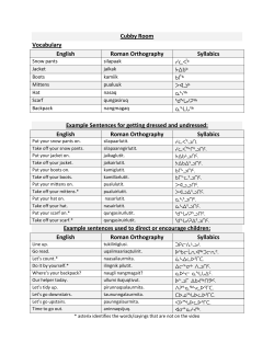


© Copyright 2026