
MEDSTEAD & FOUR MARKS NEIGHBOURHOOD PLAN 2015 â 2028
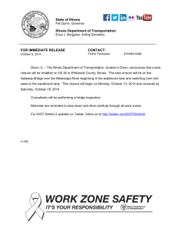
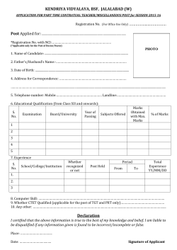
MEDSTEAD & FOUR MARKS NEIGHBOURHOOD PLAN 2015 – 2028 Green Routes Study April 2015 1 Green Routes Study Introduction As part of the Medstead & Four Marks Neighbourhood Plan a proposal was made for a Green Infrastructure network within Medstead & Four Marks which resulted in the development of Policy 9. Policy 9: Medstead & Four Marks Green Infrastructure Network The Neighbourhood Plan proposes the establishment of the Medstead & Four Marks Green Infrastructure Network around and within Four Marks/South Medstead and Medstead Village. The Network comprises a variety of green infrastructure assets, including Local Green Spaces and Open Spaces, as identified in Policy 6, playing fields, landscaped noise attenuation buffers, assets of biodiversity value and children’s play areas. It also includes heritage routes, cycleways, footpaths and bridleways and links with the Medstead Village Wild Flower Walk of Policy 8. Development proposals on land that lie within the broad location of the Network will be required to align their public open space and other amenity requirements with its objectives, so that they may contribute to its successful formation and maintenance . This policy proposes the creation of the Medstead & Four Marks Green Infrastructure Network in and around the villages as a network of existing and new assets, including the existing network of footpaths, heritage routes, bridleways, cycleways, public open spaces and other outdoor recreational and leisure assets within which to contain site allocations and improve connectivity. The network will be delivered and maintained over the plan period and beyond. As such it accords with the NPPF (Para 114) and Policy CP20, CP21 and CP28 of the JCS on green infrastructure. The scale of development in recent years around the settlements of Four Marks and South Medstead has meant that the need for a green infrastructure network has become more important to the community. The existing public network will be the basis of the Green Infrastructure network and further routes will be established to improve the movement between the villages, the Wild Flower Walk in Medstead, the Railway Station Hub between South Medstead and Four Marks and the surrounding landscape. It will importantly join up most of the Local Green Spaces in the MFMNP area to maximise the enjoyment and recreational use of these. The aim is to significantly improve ecological connectivity around and through the villages and beyond through a variety of measures. Therefore the policy requires all development proposals in the vicinity of the Network to demonstrate how they will contribute to its successful formation and maintenance. Importantly, the policy also resists the loss of Network features unless the development proposals can show that the Network can be reconnected effectively. 2 Proposed Green Infrastructure Network 3 The following routes have been identified by the MFMNP working groups: The Medstead route Eastern Route • Existing - there is a track known as Stoney Lane that runs north from Station Approach opposite the level crossing gates all the way to Five Ash Road. A public footpath continues north opposite the end of Stoney Lane and continues to the bend in Roe Downs Road. • Proposal – to form a new footpath on the inside of the hedge line continuing north until it reaches the Bowls Club. There are ongoing discussions about the pavement that runs from the football field to the entrance to the tennis club to see if it could be extended to the southern boundary of the bowls club. This would then give a safe pedestrian walk from the Four Marks centre to the Medstead village centre. Western Route • Existing – the pavement ends at Station Approach when travelling north, however Hampshire Highways are believed to be about to start on the construction of a footpath running from the A31 to Five Ash crossroads on the western side of Lymington Bottom Road. There are public footpaths that run from just north of Five Ash crossroads to Greenstile although a little muddy at times. • Proposal – continue the style of Hampshire Highways new footpath the few yards north of Five Ash crossroads until it meets the entrance to The Knapp. Cut back vegetation to give a slightly wider access and upgrade the surface of the existing footpaths all the way to Greenstile. This would then give a safe pedestrian walk from the Four Marks centre to the Medstead village centre avoiding the very dangerous Southtown Road. A route slightly shorter than keeping to the road. The Four Marks route Existing - Clockwise- From the Railway Station, the route heads south, crossing the A31 at Oak Green Parade. It turns east and follows the road to a footpath on the right, towards Badger Close. It then crosses Blackberry Lane and continues on the footpath to Alton Lane. St Swithun’s Way, Four Marks 4 Crossing the road at the Garden Centre and then turning right onto St Swithun’s Way the route arrives at Kitwood Lane close to its junction with Kitwood Road. Turning NW the path then traverses a large field and into the centre of Old Down Wood where two options are available: i. At the junction the route turns east back through open fields, passing the proposed Wildflower Meadow and then follows northwest at Gradwell Lane to the junction with The Pilgrims Way at Brislands Lane. or ii. Continuing straight through Old Down Wood and turning east onto Brislands Lane (Pilgrims Way)the route then meets with the junction with Gradwell Lane. Pilgrims Way, Four Marks Following the public by-way, opposite the end of Gradwell Lane, the route heads toward Barn Lane. Upon reaching the open fields it turns east, joining the recreation ground and returns to the village centre, south via Uplands Lane and northeast on the Pilgrims Way, then via Yarnhams Close and using the footpath leading to the shopping parade. Proposal - There is an aspiration to create a footpath from the recreation ground to Lymington bottom opposite the junction with Lymington Rise. From here the route could return to the Oak Green Parade via the footpath from Read’s Fields or could turn north on Lymington Bottom, meeting with the Medstead route at the junction with the A31. Existing anti-clockwise - The route travels southeast along Barn Lane, taking the left fork at the wooded area, then either; i. Turning east along Brislands Lane where it joins the Pilgrims Way. or 5 ii. Continue along Gradwell lane to Five Ways, south on Kitwood Road then northwest at the top of the road picking up St Swithun’s Way to Old Down Wood at the junction in the centre of the Wood it turns east, following the path through open fields towards Gradwell Lane (passing the proposed Wildflower Meadow and turns northwest at Gradwell Lane meeting with the Pilgrims Way at Brislands Lane. Following Brislands Lane, past the recreation ground and crossing the junction to Blackberry Lane (remaining on Pilgrims Way). The route then turns north at Yarnhams Close, towards Read’s Fields and then northeast along the footpath toward the back of the shopping parade. It then crosses the main road and continues along Station Approach, toward the Railway Station. 6


© Copyright 2026