
DEVELOPMENT CONTROL COMMITTEE THURSDAY 19 MARCH
DEVELOPMENT CONTROL COMMITTEE
THURSDAY 19 MARCH 2015
REPORT BY
HEAD OF PLANNING & TRANSPORT
PLANNING APPLICATIONS
INDEX
ITEM
NO
REGISTER
NO
A1
14/10306
A2
14/13278
A3
14/15023
Report 339807
ADDRESS
DESCRIPTION
RECOMMENDATION
Tolworth Girls School And Hybrid application for erection of 2 x 3 PERMIT
Tolworth Rec, Fullers Way storey buildings (Use Class D1) to
North, Surbiton, KT6 7LQ
facilitate extensions and remodelling of
existing school, highway works, sports
provision and landscaping under full
permission and outline consent for
erection of up to 106 residential units
(access and layout to be considered)
(For full details of proposed works - refer
to application form).
Town
House
Kingston Demolition of the existing Town House PERMIT
University,
Kingston
upon building and erection of a new teaching
Thames, KT1 2EE
building (9,320 sqm GIA) for Kingston
University, along with associated
access, parking and landscaping works.
Kingston Hospital NHS Trust, Alterations to facade and layout of PERMIT
Kingston Hospital Galsworthy existing car park with addition of 1 extra
Road, Kingston upon Thames, storey to increase capacity from 275 to
Surrey, KT2 7QB
405 parking spaces.
PAGE
NO
A3
A51
A80
DEVELOPMENT CONTROL COMMITTEE
19TH MARCH 2015
REPORT BY THE
Head of Planning & Transport
PLANNING APPLICATIONS
All recommendations for planning permission in this section are automatically subject
to the condition limiting the duration of the permission required by Sections 91 and 92
of the Town and Country Planning Act (as amended) 1990 unless permission is to be
granted for a limited period or unless there is a specific recommendation that the
period for such duration be other than the period referred to in the standard
condition. All background papers are incorporated into Planning Application Reports.
The policies listed are those from the Royal Borough of Kingston upon Thames the
Local Development Framework Core Strategy, Adopted April 2012.
Development Control Committee
Date of Meeting: 19/03/2015
A1
Register No:
14/10306/FUL
Address:
TOLWORTH GIRLS SCHOOL AND TOLWORTH
REC, FULLERS WAY NORTH, SURBITON, KT6
7LQ
(c) Crown Copyright. All right reserved. Royal Borough of Kingston 2007. Licence number
100019285.
[Please note that this plan is intended to assist in locating the development it is not the site
plan of the proposed development which may have different boundaries. Please refer to the
application documents for the proposed site boundaries.]
Ward:
Description of Proposal:
Plan Type:
Expiry Date:
Tolworth and Hook Rise
Hybrid application for erection of 2 x 3 storey
buildings (Use Class D1) to facilitate extensions and
remodelling of existing school, highway works, sports
provision and landscaping under full permission and
outline consent for erection of up to 106 residential
units (access and layout to be considered).
Full Application
01/12/2014
Applicant's Plan Nos:
1430_100 P5 - Existing Location Plan
Received
01/09/2014
1430_101 P4 - Existing Block Plan
Received
01/09/2014
1430_102 P3 - Topographical Survey
Received
01/09/2014
1430_103 P9 - Site Areas
Received
01/09/2014
1430_110 P3 - Existing Ground Floor Plan
Received
01/09/2014
1430_115 P3 - Existing First Floor Plan
Received
01/09/2014
1430_120 P3 - Existing Roof Plan
Received
01/09/2014
1430_130 P3 - Existing Elevations
Received
01/09/2014
1430_131 P3 - Proposed Buildings
Demolished (1 of 2)
Received
01/09/2014
1430_132 P3 - Proposed Buildings
Demolished (2 of 2)
Received
01/09/2014
1430_140 P7 - Proposed Location Plan
Received
01/09/2014
1430_141 P7 - Proposed Block Plan
Received
01/09/2014
1430_142 P6 - Outline and Full Planning
Application Areas
Received
01/09/2014
1430_150 P6 - Proposed Ground Floor
Plan
Received
01/09/2014
1430_151 P6 - Proposed Ground Floor
Plan (1 of 2)
Received
01/09/2014
1430_152 P6 - Proposed Ground Floor
Plan (2 of 2)
Received
01/09/2014
1430_155 P5 - Proposed First Floor Plan
Received
01/09/2014
1430_156 P5 - Proposed First Floor Plan (1
of 2)
Received
01/09/2014
1430_157 P5 - Proposed First Floor Plan (2
of 2)
Received
01/09/2014
1430_160 P5 - Proposed Second Floor
Plan
Received
01/09/2014
1430_165 P5 - Proposed Roof Plan
Received
01/09/2014
1430_166 P5 - Proposed Roof Plan (1 of 2)
Received
01/09/2014
1430_167 P5 - Proposed Roof Plan (2 of 2)
Received
01/09/2014
1430_175 P5 - Proposed Sections (1 of 2)
Received
01/09/2014
1430_176 P6 - Proposed Sections (2 of 2)
Received
01/09/2014
1430_180 P5 - Proposed Elevations Key
and Dimensions
Received
01/09/2014
1430_181 P5 - Proposed Elevations (1 of 6) Received
01/09/2014
1430_182 P5 - Proposed Elevations (2 of 6) Received
01/09/2014
1430_183 P5 - Proposed Elevations (3 of 6) Received
01/09/2014
1430_184 P5 - Proposed Elevations (4 of 6) Received
01/09/2014
1430_185 P5 - Proposed Elevations (5 of 6) Received
01/09/2014
1430_186 P5 - Proposed Elevations (6 of 6) Received
01/09/2014
1430_190 P4 - Existing Site Constraints
Received
01/09/2014
1430_191 P4 - Proposed Development
Phase 1
Received
01/09/2014
1430_192 P5 - Proposed Development
Phase 2
Received
01/09/2014
1430_193 P5 - Proposed Development
Phase 3
Received
01/09/2014
1430_194 P5 - Completed Development
Phases
Received
01/09/2014
1430_195 P3 - Existing Ground Floor
Faculty Plan
Received
01/09/2014
1430_196 P3 - Existing First Floor Faculty
Plan
Received
01/09/2014
1430_197 P5 - Proposed Ground Floor
Faculty Plan - Indicative
Received
01/09/2014
1430_198 P5 - Proposed First Floor Faculty
Plan - Indicative
Received
01/09/2014
1430_199 P5 - Proposed Second Floor
Faculty Plan - Indicative
Received
01/09/2014
1430_210 Rev A - Illustrative Residential
Masterplan
Received
01/09/2014
1430_A P2 - Proposed Perspective A Pupil
Entrance
Received
01/09/2014
1430_B P2 - Proposed Perspective B
Performance Courtyard
Received
01/09/2014
1430_C P2 - Proposed Perspective C
Dining Courtyard
Received
01/09/2014
1430_D P3 - Proposed Perspective C Aerial Received
View
01/09/2014
Appendices to Transport Assessment
Received
01/09/2014
Arboricultural Impact Assessment
(Residential Site)
Received
01/09/2014
Arboricultural Impact Assessment (School
Site)
Received
01/09/2014
Arboricultural Method Statement
(Residential Site)
Received
01/09/2014
Arboricultural Method Statement (School
Site)
Received
01/09/2014
Arboricultural Report
Received
01/09/2014
Biodiversity Enhancement Plan
Received
01/09/2014
Community & Stateholder Consultation
Received
01/09/2014
Cultural Heritage Desk Based Assessment
Received
01/09/2014
Design & Access Statement
Received
01/09/2014
Design code for Proposed Residential
Development
Received
01/09/2014
Extended Phase 1 Habitat Survey
Received
01/09/2014
Flood Risk Assessment & Surface Water
Drainage Strategy
Received
01/09/2014
Floodlight Strategy
Received
01/09/2014
Framework Residential Travel Plan
Received
01/09/2014
GLEE 18693 10C - Landscape Masterplan
Received
01/09/2014
GLEE18693-11A (Sheet 1 of 5)
Received
01/09/2014
GLEE18693-11A (Sheet 2 of 5)
Received
01/09/2014
GLEE18693-11A (Sheet 3 of 5)
Received
01/09/2014
GLEE18693-11A (Sheet 4 of 5)
Received
01/09/2014
GLEE18693-11A (Sheet 5 of 5)
Received
01/09/2014
GLEE18693-12A (Sheet 1 of 5)
Received
01/09/2014
GLEE18693-12A (Sheet 2 of 5)
Received
01/09/2014
GLEE18693-12A (Sheet 3 of 5)
Received
01/09/2014
GLEE18693-12A (Sheet 4 of 5)
Received
01/09/2014
GLEE18693-12A (Sheet 5 of 5)
Received
01/09/2014
Health Impact Assessment (August 2014)
Received
01/09/2014
Internal and External Bat Survey
Received
01/09/2014
Landscape Design Statement (Residential
Site)
Received
01/09/2014
Landscape Design Statement (School Site)
Received
01/09/2014
Noise, Air Quality and Odour Assessment
Received
01/09/2014
Phase 1 - Geo-Environmental Desk Study
Received
01/09/2014
Planning Statement (August 2014)
Received
01/09/2014
Reptile Presence/Likely Absence Survey
Received
01/09/2014
School Travel Plan 2013/2014
Received
01/09/2014
Soft Landscape Specification (School Site)
Received
01/09/2014
Statement of Educational Need
Received
01/09/2014
Sustainable Design & Construction
Statement
Received
01/09/2014
Transport Assessment
Received
01/09/2014
Tree Protection Plan (Residential Site)
Received
01/09/2014
Tree Protection Plan (School Site)
Received
01/09/2014
Tree Reference Plan
Received
01/09/2014
BASIC INFORMATION
National Planning Policy Framework (NPPF) 2012
Development Plan:
London Plan July 2011
LDF Core Strategy Adopted April 2012
Policies
T1
LP 2.6
LP 2.7
LP 2.8
LP 3.10
LP 3.11
LP 3.12
LP 3.13
LP 3.18
LP 3.19
LP 3.3
LP 3.4
LP 3.5
LP 3.6
LP 3.7
LP 3.8
LP 4.7
LP 5.1
LP 5.10
LP 5.11
LP 5.12
LP 5.13
LP 5.18
UNITARY DEVELOPMENT PLAN
Transport Safety
LONDON PLAN JULY 2012
Outer London: vision and strategy
Outer London: economy
Outer London: transport
Definition of affordable housing
Affordable housing targets
Negotiating affordable housing on indivi
Affordable housing thresholds
Education facilities
Sports facilities
Increasing housing supply
Optimising housing potential
Quality and design of housing developmen
Children and young people’s play and inf
Large residential developments
Housing choice
Retail and town centre development
Climate change mitigation
Urban greening
Green roofs and development site environ
Flood risk management
Sustainable drainage
Construction, excavation and demolition
LP 5.2
LP 5.21
LP 5.3
LP 5.6
LP 5.7
LP 6.11
LP 6.12
LP 6.13
LP 6.2
LP 6.3
LP 6.4
LP 6.7
LP 6.9
LP 7.14
LP 7.19
LP 7.2
LP 7.3
LP 7.4
LP 7.6
LP 8.2
LP 8.3
CS 01
CS 02
CS 03
CS 05
CS 06
CS 07
CS 08
CS 09
CS 10
CS 15
CS 16
DM01
DM02
DM03
DM04
DM05
DM06
DM08
DM09
DM10
DM11
DM13
DM17
DM19
DM23
Minimising carbon dioxide emissions
Contaminated land
Sustainable design and construction
Decentralised energy in development prop
Renewable energy
Smoothing traffic flow and tackling cong
Road network capacity
Parking
Providing public transport capacity and
Assessing effects of development on tran
Enhancing London’s transport connectivit
Better streets and surface transport
Cycling
Improving air quality
Biodiversity and access to nature
An Inclusive environment
Designing out crime
Local character
Architecture
Planning obligations
Community infrastructure levy
LDF CORE STRATEGY CORE POLICIES
Climate Change Mitigation
Climate Change Adaptation
The Natural and Green Environment
Reducing the Need to Travel
Sustainable Travel
Managing Vehicle Use
Character, Heritage and Design
Waste Reduction and Management
Housing Delivery
Future Needs of Kingston University, Kin
Community Facilities
LDF CORE STRATEGY DEVELOPMENT MANAGEMENT
Sustainable Design and Construction Stan
Low Carbon Development
Designing for Changing Climate
Water Management and Flood Risk
Green Belt, Metropolitan Open Land (MOL)
Biodiversity
Sustainable Transport for new Developmen
Managing Vehicle Use for New Development
Design Requirements for New Developments
Design Approach
Housing Quality and Mix
Protecting Existing Employment Land and
Protecting Existing Retail Uses
Schools
Previous Relevant History
05/10329/FUL
Erection of 2 storey vocational
Permit with expiry
condition + condition
education block
08/12/2005
06/10040/FUL
Formation of new parking area
adjacent to Tolworth Gym Club
Permit with expiry
condition + condition
04/05/2006
07/10097/FUL
Erection of 2 x 20 unit cycle shelters
Permit with expiry
condition + condition
25/05/2007
08/10145/FUL
Retention of two temporary
buildings within the
quadrangle/playground providing
two temporary classrooms and
study areas, (relaxation of Condition
2 of planning permission
03/10157/FUL).
Permit Conditions
24/07/2008
08/10166/FUL
Erection of cold store and walk in
freezer room to canteen block
including associated elevational
alterations
Permit with
conditions
10/12/2008
09/10095/FUL
Retrospective permission for the
erection of a modular building to the
rear of the main building and west of
the playground
Permit with
conditions
25/02/2010
09/10157/FUL
Erection of single storey extension
to gymnasium
Permit with
conditions
25/02/2010
10/10035/FUL
Installation of Roof Safety System
comprising of 338 Metres of Free
Standing Guard Rail System with 4
No. Access Ladders and Standing
Guard Rail around 12 No. Existing
Roof Lights
Permit with
conditions
15/06/2010
12/10082/FUL
Installation of protective railings to
flat roof
Permit with
conditions
08/06/2012
14/10013/PRE
Development of 144 units
comprising a mixture of three storey
flats and houses with associated car
parking areas, a new pedestrian link
to Chaffinch Close and possible
emergency access to the A3
Response Sent
02/05/2014
Consultations
1. Neighbouring Occupiers: 1213 notification letters have been sent, and the
proposal has been advertised in the local press and by way of site notices.
A total of 36 representations have been received (25 responses in
objection and 11 responses in support) of the scheme. An additional
petition has also been submitted with 128 signatories against the
development proposal. The objections can be summarised as follows:
- Parking problems would increase given the proposed increase in
residential units and also as a result of the proposed school
expansion;
- Proposal would lead to increase pollution for surrounding residents
and the potential occupiers of the school and residential elements as
proposed;
- Amenity Space is substandard;
- Loss of Open Space and development on school sports pitches is
unacceptable
- Inappropriate layout and design given that one long access road is
proposed with no clear or useable pedestrian routes;
- Poor design of streets and layout given that the housing element
would be segregated from the surrounding area;
- Poor linkages and permeability
- Pedestrian and vehicle conflict and highways safety matters raised
including the potential increased pressure on the junction between
Fullers Way North and the A3 given the increased pupil numbers and
residential users on top of the existing users of this junction, which
also include lorries accessing the neighbouring business park.
- Environmental issues including pollution and noise and disturbance
for the neighbouring residential properties as a result of the increased
residents and school users and also during the construction period
relating to the size of the scheme.
- Drainage and surface run-off and through-flow concerns given the
proposed quantum of new hard-standing on an otherwise open area;
- Contamination matters will compromise the health and safety of
prospective residential occupiers;
- Implications of the residential element on services and local
infrastructure;
2. Kingston upon Thames Society: Recognise that there is a shortage of
school places in Kingston and encourage such educational expansion,
although there remain concerns in relation to the proposed residential
development that would fund the school expansion, including the lack of
secondary access routes (Selbourne Avenue could be considered);
3. English Heritage (Archaeology Officer):
No objections subject to
conditions.
4. Transport for London: Raise concerns including; (a) robust improvement is
recommended to the turning between Fullers Way North and the A3 given
existing and forecast traffic volumes and safeguarding of Tolworth
Recreational Land should be implemented to help achieve such
measures. The proposed development will generate additional demand on
bus services. Even a small increase in passenger numbers would push
the K1 route over capacity. TFL are therefore seeking a contribution to
fund an additional school journey for the K1 route for 3 years. At £70,000
per year the contribution sought is £210,000. This should be secured
through the s106 agreement. TFL still require the provision of the bus
turning facility. Having a dedicated school bus for Tolworth Girls would
release some pressure of the K1 and other routes - a turning facility at this
location would allow the school route to turn as well as giving direct
access into and out of the school. Without the tuning point, the only other
turning point would be on the A3 - which is not advisable. However, TFL
recommends that the turning point is reversed - this would allow the bus
stop on the opposite side thus improve access into and out of the site. The
current arrangement would prove difficult for buses turning left into the
facility to pull level to the kerb at the proposed stop. TFL recommends that
the proposed re-profiling of the kerb line of the Fullers Way North / A3
junction is not undertaken.
TFL have developed a scheme for
improvements to this junction and therefore seek a 15% contribution
towards this scheme which equates to £224,500. This should be secured
through the s106 agreement. Subject to the above, the proposal as it
stands would not result in an unacceptable impact to the Transport for
London Road Network (TLRN).
5. Neighbourhood Traffic Engineer: Raise concerns in-line with TFL
objections.
6. Sustainability Officer: No objections subject to conditions.
7. Tree and Landscape Officer: No objection, subject to submission of
detailed landscape plan. The tree protection details are acceptable.
8. Environmental Health Officer: No objection in principle, subject to
conditions.
9. Environment Agency: No objections, subject to conditions to secure the
submitted drainage schemes.
10. Sport England: Raise objections based on loss of playing pitches, the
scheme fails to meet the 'exceptions' tests.
11. Should the planning committee resolve to grant planning permission then
the application would be referable to the Secretary of State.
12. MET Police Crime Prevention Officer: Recommend that security measures
to be incorporated where possible.
Site and Surroundings
13. The application site relates to an existing secondary school (Tolworth Girls
School & Sixth Form) and the associated fields (5.96 hectares in area).
The site is accessed off the eastern side of Fullers Way North. The
application site is bounded to the south by the A3 and Tolworth Recreation
Centre and to the north by the Red Lion Road industrial estate. To the east
and the west of the application site are large, low density residential
neighbourhoods, along with a traveller's settlement that is located to the
south-east (Swallow Park).
14. The existing school comprises a mix of one and two storey buildings with
car parking to the west and playing fields to the east. A number of the
existing single storey buildings are temporary buildings that are in a
dilapidated condition.
15. The application site is located within the Tolworth Key Area of Change
policy designation. The land to the east of the school buildings is
designated as School Open Space and the industrial site on Red Lion
Road is a Locally Significant Industrial Site. The entrance to the site off
Fullers Way North is also designated as an area of Archaeological
Significance.
16. The existing Tolworth Girls School and Sixth Form has been an
educational provider within the Borough since 1932. The current school
and associated sixth form operates with a 7-form entry system, with a total
of 1,350 pupils on the school roll, of which 300 of the pupil numbers are
sixth form students.
Proposal
17. Planning permission is sought by way of a hybrid application relating to the
proposed erection of 2 x 3 storey buildings (Use Class D1) to facilitate
extensions and remodelling of existing school, highway works, sports
provision and landscaping under full permission and outline consent for
erection of up to 106 residential units.The matters reserved include
landscaping, appearance and scale, whilst access and layout are for
determination at this stage in the context of the outline application
element. The proposal, although linked comprises the 'enabling' residential
development (within the north-east part of the site) that would facilitate the
proposed educational development of the school. The outline residential
part of the application comprises a total site area of 2.07 hectares, which
includes the contaminated land (1.82 hectares), together with an area of
playing fields to the south for use as a pedestrian/cycle/emergency access
road (0.28 hectares). The detailed element of the scheme subject to the
full planning element comprises a total site area of 4.2 hectares, including
the former school buildings and land to the east. In this respect, the
proposed new school buildings would be constructed on previously
developed school land and the replacement sports provision would
comprise former motor cycle testing land and school sports land.
Assessment
The main considerations material to the determination of this application are:
•
•
•
•
•
•
•
•
Principle of Proposed Development
Impact on Character of Area
Impact on Neighbour’s Residential Amenity
Highways and Parking
Trees
Legal Agreements
Sustainability
Other Material Considerations
Principle of Proposed Development
18. Policy CS15 (Future Needs of Kingston University, Kingston College
and Schools) states that the Council will facilitate improvements to the
school estate and make provision for a permanent increase in the
number of school places to meet increasing demand through the
expansion of existing schools and the provision of new schools.
Potential for shared and community use will be provided for.
19. Policy DM23 (Schools) states that the Council will:
(a) designate and protect open space on school sites as shown on
the Proposals Map and seek to ensure that school expansion
proposals retain open space and that all options to reorganise/expand schools within the existing built footprint are
explored, with a presumption against a net reduction in open
space.
(b) assess proposals for new schools and school expansion
against the following criteria:
i. the size of the site, its location and suitability to
accommodate a new school or school expansion taking
account of compatibility with surrounding uses, and
existing planning policy designations (e.g. Conservation
Areas, MOL, Green Belt)
ii. the impact on green open space, games pitches,
outdoor play and amenity space, taking account of the
character of the area, whether the site is within an area
of open space deficiency and whether the school has
sufficient outdoor space for play and games
iii. the location and accessibility of the site in relation to:
- the intended catchments area of the school
- public transport
- the local highway network and its ability to
accommodate new or additional school trips
without adverse impact on highway safety
- safe and convenient walking and cycling routes to
schools
iv. the extent to which the building design contributes
towards the government target that schools and colleges
should be zero carbon from 2016.
20. Policy CS3 (The Natural and Green Environment) states that the
Council will protect and improve Kingston's valued natural and green
environment by:
- (c) protecting Kingston's open space network from
inappropriate development through its open spaces
designations; Green Belt, Metropolitan Open Land (MOL),
Thames Policy Area, Sites of Importance for Nature
Conservation (SINCs), Local Nature Reserves, Local Open
Space, School Open Spaces, Green Corridors, Green
Chains and Allotments, as shown on the Proposals Map.
- (d) incorporating appropriate elements of public open space
into new developments and/or making a financial
contribution to improving existing open spaces, with
additional facilities and better management to Green Flag
standards.
- (e) promoting the management of biodiversity in light of the
threats arising from climate change and future development
growth, by working in partnership with a range of
organisations on projects to protect and enhance
Kingston's Open Space Network. This will not only provide
increased wildlife habitats, but will also link wider parts of
Kingston, allowing easier movement and reducing isolation
of habitats.
-
(f) protecting and enhancing Kingston's playing fields and
ensuring that opportunities for the extension of existing
provision or new recreation, children's play and sports
facilities are encouraged; especially those that meet
identified needs.
21. Policy DM5 (Green Belt, Metropolitan Open Land (MOL) and Open
Space Needs) states that the Council will:
- (g) ensure new development contributes to the provision
and improvement of the quality, quantity, variety and
accessibility of public open space, play and sports facilities,
to meet the needs it generates in accordance with the local
provision and accessibility standards set out in Annex 3 and
the Planning Obligations SPD, or Community Infrastructure
Levy charge.
- (h) ensure that development proposals do not result in the
whole or partial loss of public open space, outdoor
recreation facilities or allotments unless a replacement site
or facility provides a net benefit to the local community and
visitors in terms of the quality, availability and accessibility
of open space or recreational opportunities.
- ensure that development proposals do not harm open
spaces which:
i. contribute to the character, appearance and
heritage value of the Borough's open space
network
ii. create focal points and valuable amenity space
within the built up area
iii. form part of an area of value for wildlife, sport or
recreation
- (j) ensure all new provision of sports and play meet
qualitative standards and optimise accessibility to all users,
including the local community and visitors.
22. London Plan Policy 3.18 - Education Facilities, states that
development proposals which enhance education and skills provision
will be supported, including new build, expansion of existing facilities
or change of use to educational purposes. Loss of Open Space
23. The application would result in the loss of School Open Space as
identified on the Council's LDF Proposals Map. Policies CS3 and
DM5 of the Council's LDF Core Strategy therefore apply. It has been
stated by the applicant that permission to release this land for
development has been obtained by the Department for Education
(DfE). During this process the School was able to demonstrate that
the loss of this land is acceptable, subject to conditions. In this
respect, the outline and detailed planning boundaries have been
dictated by the area that the Secretary of State for Education formally
approved for release on 1st July 2014.
24. Furthermore, the main part of the site that would be lost by
development relates to the north-eastern plot of the application site,
which has been identified as contaminated land measuring 2.01
hectares in area. This area has not been used as sports playing
pitches for more than 5 years prior to the submission of the
application as a result of the contaminants that have been identified
during previous analysis and also the general condition of the land.
The low grade school land that would be lost for the residential
element and the north-to-south access road (for cycling/pedestrians
and emergencies) would facilitate the 'enabling' residential
development that would fund the 'phased' development of the school.
25. The proposals seek a comprehensive development to facilitate
improvements and upgrading of the existing school facilities and the
potential to expand from a seven form to an eight form entry (and
increase on the current annual intake of 201 to 240 pupils by
September 2015) and an increase in the total 6th form intake from
300 to 400 pupils. The total number of new school places that would
be provided by the phased school expansion would equate to 250
places.
Educational Element
26. The phased development elements of the Tolworth Girls School
expansion would comprise:
Phase 1:
27. Proposed 3-storey teaching/dining and sixth form centre to provide:
- Dining facilities and kitchen;
- Replacement food technology classroom;
- Additional IT facilities;
- Additional science laboratories;
- Business studies classrooms
28. This element of the phased development comprises a new building
that would be located on the site in order to allow construction to be
completely separated from pupils and built with limited impact. The
refurbishment and rationalisation of existing, science technology and
maths blocks would be carried out during a summer holiday period.
Phase 2:
29. Comprises the demolition of the existing accommodation:
- Dining music and classroom block;
- Exam hut;
- ICT hut;
- Hairdressing and Beauty hut;
- Health & social care hut;
- Maths hut;
- Finance House
30. This phase would also incorporate:
- Construction of a new road;
- Construction of the proposed Multi Use Games Area
(MUGA)
Phase 3:
31. Proposed erection of a 3-storey building for use as a teaching, music
& arts hall and library building to provide:
- New student and staff entrances;
- Multi purpose performance hall / lecture theatre with
retractable seating;
- Improved drama and dance facilities;
- Replacement and expanded English department;
- Replacement and expanded music department;
- New media studies suite;
- Inclusion zone for pupils;
- Ancillary staff rooms.
Phase 4:
32. Demolition of the following modular buildings:
- Learning support huts;
- Sixth form modular building.
33. The scheme would also include the proposed refurbishment and
restructuring the remainder of the existing buildings to include
grouped faculty and subject areas, improved changing facilities and
expanded support and staff areas to allow for the above school
expansion plans.
34. Furthermore, whilst the overall area of open land that would be lost is
2.07 hectares, of this just 0.17 hectares is classified as open space,
with the remaining quantum of land comprising the contaminated and
unmaintained land. Policies CS3 and DM5 seek to protect against the
loss of open space and designated School Open Land, but recognise
that exceptions can be factored into the decision making process. It is
considered that the re-provision and upgrade of the existing sports
facilities and land can therefore out-weigh the loss of open space. In
this case, 2.01 hectares of land will be used to provide enhanced
sports facilities that can be used by the expanded school and the
wider community.
35. Furthermore, the use of facilities that can be used all year round in
comparison to land that is often waterlogged and unplayable for large
parts of the year, and can therefore provide social and education gain
to off-set the reduction in the open land. It should be observed that
the Secretary of State (SoS) for Education's decision to release the
land for development recognised that some of the land was
contaminated and had not been used for PE or recreation, and
furthermore that the school could still deliver adequate physical
education curriculum on land that would remain following its disposal.
36. The NPPF is clear with regards to the future houses and school place
needs. Paragraph 72 of the NPPF states that 'The Government
attaches great importance to ensuring that a sufficient choice of
school places is available to meet the needs of existing and new
communities. Local planning authorities should take a proactive,
positive and collaborative approach to meeting this requirement, and
to development that will widen choice in education. They should:
- Give great weight to the need to create, expand or alter
schools; and
- Work with schools promoters to identify and resolve key
planning issues before applications are submitted.
37. Additionally, London Plan Policy 3.18 (Education facilities) seeks to
ensure that development proposals which enhance education and
skills provision will be supported; including new build, expansion of
existing facilities or change of use to educational purposes and
development proposals which maximise the extended or multiple use
of educational facilities for community or recreational use should be
encouraged.
38. The applicants have submitted a Statement of Educational need
which is based on evidence based approach. Since 2002, the birthrate has risen in the Borough by 30% and is forecast to increase
further. This is derived from the Council's report (School Place
Planning Strategy, 2013-2020), and for 2015 admissions the
admissions of Tolworth Girls is projected to increase from 210 to 240.
39. The proposed school expansion would deliver its strategic objectives
and meet the current curriculum shortfalls, whilst replacing substandard teaching accommodation in the following manner;
- Provision of a new sixth form centre;
- Extended library;
- Additional toilets and changing rooms;
- New music suite;
- New performing arts suite;
- Canteen and Performing Arts suite.
- Residential Provision.
- The provision of enhanced additional facilities is therefore
welcomed.
Residential Element
40. Outline consent is sought in respect to access and layout for 106
residential units that are proposed to fund the educational
development proposal to Tolworth Girls School. It should be noted
that landscaping, appearance and scale are matters that are reserved
for subsequent approval. With regards to housing need, it is
recognised that the NPPF places great importance on the delivery of
new homes. This is emphasised in the London Plan whereby
Kingston Council is set a minimum 10 year delivery target of 3,750
dwellings or 375 per year. It is also recognised that the Further
Alterations to the London Plan (FALP) seek to increase the target
number of dwellings to be delivered by Kingston Council.
41. The proposed residential development indicate an indicative housing
mix comprising:
- 19 x 1-bed units;
- 49 x 2-bed flats;
- 6 x 3 bed duplex flats;
- 32 x 3 bed houses
42. The proposed residential element would comprise 106 residential
units, equating to a density of 60 units per hectare, which is within the
London Plan density range, despite the poor PTAL rating of the site
(1a). The design (layout) and access matters will be explored below
within the urban design and highways sections respectively. It should
be noted that Sport England have maintained their objections to the
development (letter dated 10th February 2015) given that they raise
concerns that it has not been satisfactory demonstrated that the
housing site (i.e. the 'enabling' residential element) that is subject to
the 'outline' element of the current hybrid application is incapable of
forming a pitch or part of a pitch and raise concerns that the loss of
playing field is thereby acceptable against the criteria set out in
paragraph 74 of the NPPF. Sport England have stated that:
43. 'In light of the above, the development is not considered to meet
exception E3 which states: E3 - The proposed development affects
only land incapable of forming, or forming part of, a playing pitch, and
does not result in the loss of, or inability to make use of any playing
pitch (including the maintenance of adequate safety margins), a
reduction in the size of the playing area of any playing pitch or the
loss of any other sporting/ancillary facility on the site'
44. The applicants had provided additional Ground Investigation & Remediation strategy. In this respect, a ground investigation and
remediation strategy report has been prepared by BRD
Environmental Ltd following initial site investigations undertaken in
October 2013, the findings of which being updated following gas
monitoring testing completed in April 2014.
45. These investigation works identified that over the disused field area
there was a distinct topsoil layer which varied in thickness between 50
mm and 400 mm, although this was more typically between 100 mm
and 300 mm in depth;
46. Beneath the capping layer there was a deeper accumulation of
backfill material which had been used to fill in the original clay pits.
This was found to vary in thickness between 600 mm and 9.3 m and
the total depth of infill has been recorded up to 12.6 m below ground
level;
47. The investigation works also included laboratory testing of samples
collected from the site in order to assess any soil contamination risk
to human health. These concluded that within the topsoil layer that
there was no significant chemical contamination present apart from
one sample which indicated slightly raised lead levels, but the soil
was considered not to present any contamination risk. Within the
underlying capping layer, elevated levels of lead were found, these
being above the human health threshold in some of the samples
tested. In addition, elevated concentrations of Polycyclic Aromatic
Hydrocarbons (PAHs) were recorded together with high levels of
asbestos in places and therefore this layer was considered to have
significant levels of contamination present.
48. Furthermore, the applicants also commissioned environmental
surface consultancy STRI to produce a report (dated 4th February
2015) in relation to the proposed redevelopment of land adjoining
Tolworth Girls' School, Surbiton. The report concluded that the costs
of developing the area of land for use as playing pitches would
amount to £304,700. The report stated that the overall costs involved
would be substantially greater than a typical playing field development
owing to the need to import the additional quantities of topsoil and
taking measures to prevent any contamination to the users of the
facilities and surrounding environment. In addition, on the matter of
the proposed 'enabling' housing site, it should also be noted that the
applicants have stated that land in question to the north east of the
site has never been used as a playing field. This understanding is
based on discussions held with the Head Teacher, who confirmed this
in writing through the submission of a signed Statutory Declaration
(dated 26th September 2014). It is therefore considered that owing to
existing budget constraints, and the fact that this land has not been
recently used for sports provision, it is unrealistic to bring this land
back into use for sports purposes as playing pitches.
49. It should be noted that Sport England has also referred to the final
Kingston Playing Pitch Strategy (PPS) document, dated 30th January
2015 in the context of their final consultation response (10th February
2015). Specifically, that the PPS indicates a shortfall in a number of
pitch types and a need to identify sites to accommodate this shortfall.
Tolworth Girls School is one of the referred sites. Sport England
considers that there is a strategic need to this site to be retained and
to be brought back into use. However, this Playing Pitch Strategy
report has not been formally adopted by the council and is currently in
draft format and does not carry any weight in the decision making
process at this time. In any event, as referred above, it is not feasible
for the reuse of this land to be brought back into use.
50. It is also considered that the use of this part of the development site
for the 'enabling' resident development will facilitate many more wider
'net' benefits for both the schools pupils and the local community
through the provision of sports surfaces and facilities that would be
able to be used more intensively and all year round. In this respect,
the applicants have produced a supporting 'Assessment of Sporting
Benefits” report to accompany the application which highlights (Inter
Alia) the wider net benefits of the proposal and also the rationale
behind the proposed facilities. The report states that:
51. 'At the moment, the schools outdoor playing facilities are woefully
inadequate and of very poor quality. Whilst they extend to some 1.82
hectares, they are badly drained and waterlogged during the winter
months. The playing pitches are currently only used for 7 months of
the year between April and October, during which the school has
many weeks of set holidays for its pupils'. The paper also sets out the
'net' benefits of the application that include
52. Multi Use Games Area (MUGA) / Grassed Sports Areas
53. The Multi-Use Games Area (MUGA) the School is proposing has
external dimensions of 78m x 53.5m (including fencing), whilst the
dimensions of the actual pitch within the MUGA (not including the
areas between the lines and the fencing) are 72m x 45m. In terms of
the surface treatment, a durable multi-sport 'Polymeric' surface that
would provide a highly durable surface for all year round sports
provision. The range of sports that would be able to be played would
include the following:- Football (9-a-side);
- Basketball;
- Hockey;
- Tennis;
- Netball
54. Furthermore, a long jump pit would also be provided, and the wider
proposal on the grassed surface areas also includes the provision for:
- Rounders' pitches;
- A multi-use throwing area (for javelin, discuss and shotput);
- A 100m running track;
- Multi Stage fitness areas.
55. The application has also be amended since the original submission to
include the provision of a marked-out grass football pitch, which
would measure 60 x 36m, therefore the proposed football pitch could
accommodate 7 v 7 in size (with allocated run-off). The proposed
layout with the grassed football pitch (located to the south-west of the
proposed MUGA) has been tabled in the form of Master Plan drawing:
GLEE 18693 10D. The proposed pitch would be available for
community use outside school hours, and, as it will be floodlit, this will
include in the evenings. Car parking would also be provided to serve
community use of the MUGA. Furthermore, it should be noted that the
school currently operates 16 'outreach' schemes with local primary
schools in the area which the MUGA would also be made available
for as wells as the proposed grassed pitches and facilities in this case
at certain times during the academic year.
56. Notwithstanding the benefits of the scheme to the school and
community, there would also be benefits for the Tolworth Recreation
Centre (TRC) and Tolworth Gymnastics Club that are also on site. In
this respect, it should be noted that the poor condition of the existing
playing field (primarily in terms of drainage) means that it cannot be
made available for the local community for use outside of school
hours (as in the case of the TRCs indoor facilities). The layout and
specification of the proposed sports facilities (including the MUGA)
have been designed in conjunction with the TRC. In particular, the
size and surface treatment of the proposed MUGA has been agreed,
along with the proposed site layout that includes independent access
(without having to go through the school), and car parking. The
applicants have confirmed that the out-of-hours community use of the
facilities would be managed by TRC, and the school (TGS) would
enter into a Community Use Agreement with the TRC and RB
Kingston to this effect in order to ensure the longer term community
usage of these new facilities.
57. Furthermore, Tolworth Gymnastics Club currently has a lease of the
existing premises that is located to the north of the application site on
the school campus. The applicants have confirmed in writing that the
Secretary of States approval to the school for it to sell off the land that
it does not need, includes the sale of the freehold of the premises to
the TGC. This would secure its medium and long term future, thereby
providing a more stable platform for the clubs further development.
58. Overall, it is considered that the existing outdoor space contributes
very little to the sport and recreation needs of the school and local
community, especially given the limited range of sports and also the
restricted months of use owing to the ground conditions. The
proposed sports facilities at the school would provide a significant
community benefit, which will be secured through the proposed
section 106 agreement and conditions. It is also considered that the
land scheduled for residential development cannot reasonably be
brought back into use as sports pitches, certainly not in the
parameters of current school budgets. Furthermore, given the fact
that this land has not been used historically for sports provision and is
isolated, overgrown and not practical for such purposes. It is therefore
considered that Sport England's objections can be mitigated in these
circumstances. As such, the proposal would be in accordance with
London Plan Policy 3.18 and Policies CS3, CS15, DM5 and DM23 of
the Council's LDF Core Strategy 2012.
59. Due to the maintained Sport England objections (as referred to
above), should members resolve to grant planning permission
(subject to a s106 agreement and conditions), then in accordance
with The Town and Country Planning (Consultation) (England)
Direction 2009 and National Planning Policy Guidance the application
will be referred to the Department for Communities and Local
Government.
Impact on Character of Area
Policies and General Principles
60. Policies CS8 and DM10 of the LDF Core Strategy advise that
proposals should relate well to their surroundings and be of a high
standard of design to achieve a more attractive, sustainable and
accessible environment.
61. The residential areas of Tolworth are generally characterised by
interwar two storey semi-detached dwelling houses. Whilst it is
recognised that this is a very distinctive character of the wider area,
the development of this site should not be made to strictly conform to
this historic development.
Residential Element (Outline)
62. The applicants have indicated that there is no development partner
yet and so this element of the scheme is in outline form with (a)
landscaping, (b) scale and (c) appearance reserved for determination
at a later date. The matters for consideration at this stage relate solely
to (d) access and (e) layout. The proposed 'enabling' residential
element proposes 106 dwellings at a density of 60 units per hectare,
or 191 habitable rooms per hectare, and the site is suburban in
character with a PTAL of 1a. The quantum of development would
therefore sit comfortably in the mid-high range allowed by the London
Plan (2011), Policy 3.4.
63. A standalone Design Code document has also been produced.
Indicative scales provided indicate that the heights of the proposed
buildings would range from 2 - 4 storeys. The two/three storey
elements would be at the edges of the development site and the
buildings would step up to four storeys in the centre of the site,
addressing the proposed public open space. Overall, these scales are
considered to be appropriate and would not harm the character of the
wider surrounding area.
64. On the matter of access, it is considered that despite the fact that a
single access road would serve Tolworth Gym, the school and the
residential element of the scheme, the permeability and layout of the
proposed residential development is considered acceptable given the
physical constraints of the site (owing to the fact that there are no
access opportunities through the industrial site to the west or through
the surrounding residential streets to the north and east due to land
ownership and land use issues), and the overall design and
appearance of the proposed residential dwellings is considered to be
well thought out. Separate footpaths are also proposed, and would
continue within the site adjacent with the school redevelopment. On
both sides of the proposed new access road, the pedestrian footpaths
would then lead into the proposed central open space, that would be
flanked either side by the proposed Boulevard landscape. Finally, a
pedestrian and cycle path link is also proposed in order to provide the
residential development with connectivity with the surrounding
residential area, adjacent to the A3.
65. With regard to layout, the street hierarchy within this scheme would
provide adequate legibility, by virtue of shared surfaces, pedestrian
walkways and a north to south access road from the A3 that would
facilitate cycle and pedestrian access to the residential element only,
whilst also taking into account the requirement for emergency
vehicles and a secondary point of access (the main point being the
access road from Fullers Way North) to the south-east of the site. The
highway layout involves a number of street deflections which will
naturally also slow vehicles.
66. The layout of the scheme would also include continuous pedestrian
footways throughout and a variety in street widths which is important
to the character of the street, movement fluidity and way-finding.
Furthermore, the proposed pattern of development allows for a good
standard of daylight/sunlight, outlook and privacy (this is discussed in
more detail below). As such, the proposal in terms of the proposed
layout and access details would lead to a satisfactory development
bin respect of these areas of assessment and would thereby be in
accordance with Policies CS8, DM5 and DM10 of the LDF Core
Strategy.
Tolworth Girls School (Detailed)
67. The proposed extensions to the school involve two separate buildings
that would be located along the northern side of the existing buildings,
replacing a number of temporary buildings which are in a poor state of
repair. The buildings would be three storeys in height with a flat roof
and would be located up to the back edge of the new road.
68. The first phase development is a proposed 3 storey building to the
east of the existing science wing. The building will provide:
- New dining hall and kitchen sufficient for expanded school
of 1600 pupils.
- Replacement food technology classroom.
- Additional IT teaching rooms.
- Additional science laboratories.
- Replacement and upgraded sixth form provision including
new open plan study area, small group study rooms, games
room and sixth form snack bar.
- Business studies classrooms.
69. The proposed extensions would be located adjacent to the new
access road, whilst the performing arts building has been set back.
The existing school buildings are predominantly two storeys in height
although there are a variety of roof forms. At three storeys in height
the proposed extension would be of a greater height and mass than
the existing buildings but this is not considered to be harmful.
70. The Phase 2 building has been designed at the front of the site, to
enhance and extend the main school building and connect parts of
the existing campus together to create a strong built edge to the
school along the boundary with the new road.
71. With regard to the facades, the north east facade of the Phase 1
building will form the boundary between the school and the new
public road. A strong brick facade, with the same rhythm of full height
windows and coloured panels, provides continuity with Phase 2.
Where the new Phase 1 building meets the end of the existing design
technology and science wing, the facade of the new block is broken
down with a stepped, open wall which creates a sense of enclosure
while allowing views through to the courtyard space and the covered
ways which link the two new buildings together and to the existing
school. The covered links take the form of an extension to the cloister
at the lower levels, with brick piers extending up to support a
lightweight aluminium roof.
72. The main route through which pupils, staff and residents of the
surrounding area travel on foot, bicycle and by car would comprise
the west to east access road off Fullers Way North and also provides
access to the proposed enabling residential development. The road
would be designed as a broad avenue with a single line of structure
tree planting, following the line of the proposed road as it wraps
around the proposed corner school building to provide a vista of the
extended Tolworth Girls' School frontage. As the Boulevard continues
around the proposed building line, it would become enclosed to form
a double aspect boulevard along the northern side of the school
buildings. This opens up views through to Tolworth Gymnastics Club
and the pupil bicycle entrance, continuing through to the community
facility parking area and beyond through to the proposed adjacent
residential housing site.
73. The proposed 'phased' expansion of Tolworth Girls School would
include the demolition of a series of 6 temporary classrooms (of
varying age and condition), the 1960s's dining and music block which
is also of a sub-standard condition and the modular sixth form block.
74. The phase 1 development would comprise the 3 storey building east
of the existing science wing to (comprising sixth room centre, dining
hall, laboratories and IT suites). The north-eastern façade of the
building would form the boundary between the extended school and
the new access road. The building would be constructed in brick with
full height windows and coloured panelling.
75. The phase 1 block would be designed to ensure that it would respect
both the existing built fabric and also the architectural design of the
proposed phase 2 developments which will be assessed further
below. In terms of the detailed design, the façade of the phase 1
building would be broken down with a 'stepped' open wall,
immediately adjacent to the phase 2 component, in order to create a
sense of enclosure whilst also allowing views through to the courtyard
space and the covered ways which would link the two respective new
buildings together.
76. The covered links would take the form of an extension to the cloister
at the lower levels with brick piers that extend up to support a
lightweight aluminium roof. As the building would turn into the site
with the curvature of the proposed access road, the materials and
form would change, with the projecting element defined by a cubeform and a change in cladding on the external (cedar panelling). This
element serving the proposed sixth form centre would have a terrace
opening out to provide views across the remodelling playing surfaces
of the school.
77. The phase 2 building would be positioned at the end of the main
block, providing a bookend to the existing façade and turning the
corner along the new access road frontage. A new dual pupil and staff
entrance would be proposed at the junction at the junction between
the existing and proposed buildings, which would take the form of a
fully glazed, triple height space, set back from the façade to create a
sense of punctuation. This element of the scheme would also
comprise the new performance hall. This element would also
comprise brick cloisters which would wraparound the building on two
floors facing the courtyard. The surface treatments would comprise
lightweight cedar cladding and projecting aluminium box windows in
order to soften this building element whilst adding further visual
interest. The stair-core element would be predominantly glazed which
would allow for views of pupil movements within. Similar to the phase
1 block, a strong brick element is proposed, punctuated by a rhythm
of full height windows and coloured panels. It is considered that
bother the vertical and horizontal elements would be clearly defined,
and would be constructed in an appropriate palate of materials whilst
also ensuring that the school design is both dynamic and also
sensitive to the surrounding built form.
78. With regard to the external changes within the sports grounds, it is
proposed that the Multi Use Games Area (MUGA) is enclosed by 3m
high sports multi mesh fence with rebound panels at either end, with
lockable gates. The surface of the MUGA, has been specifically
selected (in coordination with Tolworth Girls' School & Sixth Form) to
provide a durable surface that provides a year round playable
surface. Permanent surface line markings depict the different sporting
activities, with different coloured lines coordinating with the different
sports. The floodlighting arrangements for the MUGA are specified in
the standalone Lighting Statement. However, it is considered that the
proposed playing pitches would be sufficiently separated from
surrounding residential properties so as not to have an adverse
impact.
79. The area at the front of the site that currently comprises an informal
grassed area which is currently intermittently used by rear 7 pupils will
be removed to make way for the 'gateway element' comprising the
'looped' access point off Fullers Way North to accommodate school
bus drop-offs and pick-ups, to ensure that any queuing of larger
vehicles such as buses off the Fullers Way North is mitigated. It is
considered that the proposed access, layout and environment
provided would ensure that this part of the frontage is of high visual
amenity quality. It should be observed that small elements of softlandscaping would be maintained in order to soften up this
environment and thereby provide some relief in the hard-landscaped
environment at this point.
80. In summary, it is considered that the proposal would not cause harm
to the character and appearance of the site and the surrounding area
and would be in accordance with policies CS8 and DM10 of the
Council's adopted LDF Core Strategy April 2012.
Impact on Neighbours’ Residential Amenity
81. Policy DM10 of the LDF Core Strategy seeks to safeguard residential
amenities in terms of privacy, outlook, sunlight/daylight, avoidance of
visual intrusion and noise and disturbance.
82. The closest affected residential properties are those immediately
surrounding the application site. In the case of the proposed
residential element, the properties to the north comprise the
neighbouring Selbourne Road, which would be over 29m away from
the northern element of the residential element (which would
comprise two storey dwellings). It is considered that owing to the
large separation distance and restricted scale and height at this point
of the application site would ensure that the surrounding residential
properties would not be compromised in terms of loss of amenity.
83. In the case of the proposed school expansion, the closest residential
properties would be located more than 40m away from those
dwellings to the east. Such separation distances, would ensure that
the development proposals (the new school buildings) would not have
a detrimental impact upon the amenities of these properties in terms
of loss of daylight, sunlight, privacy and outlook.
84. Overall, it is considered that the proposed development (both the
outline and full elements) would not harm the amenities of the
neighbouring residential properties. The proposal therefore accords
with Policy DM10 (k) of the Council's LDF Core Strategy. The noise
and disturbance matters pursuant to the scheme will be explored
further below.
Highways & Parking
85. Paragraph 32 of the NPPF states that all developments that generate
significant amounts of movement should be supported by a Transport
Statement or Transport Assessment. Plans and decisions should take
account of whether:
- the opportunities for sustainable transport modes have
been taken up depending on the nature and location of the
site, to reduce the need for major transport infrastructure;
- safe and suitable access to the site can be achieved for all
people; and
- improvements can be undertaken within the transport
network that cost effectively limits the significant impacts of
the development. Development should only be prevented or
refused on transport grounds where the residual cumulative
impacts of development are severe.
- Paragraph 34 of the NPPF goes on to add that planning
decisions should ensure developments that generate
significant movement are located where the need to travel
will be minimised and the use of sustainable transport
modes can be maximised. However this needs to take
account of policies set out elsewhere in this Framework.
Furthermore, Paragraph 35 of the NPPF states that
developments should be located and designed where
practical to:
- accommodate the efficient delivery of goods and supplies;
- give priority to pedestrian and cycle movements, and have
access to high quality public transport facilities;
- create safe and secure layouts which minimise conflicts
between traffic and cyclists or pedestrians, avoiding street
clutter and where appropriate establishing home zones;
- incorporate facilities for charging plug-in and other ultra-low
emission vehicles; and
- consider the needs of people with disabilities by all modes
of transport.
86. Policy 6.3 (Assessing effects of development on transport capacity) of
the London Plan states that:
- Development proposals should ensure that impacts on
transport capacity and the transport network, at both a
corridor and local level, are fully assessed. Development
should not adversely affect safety on the transport network.
- Where existing transport capacity is insufficient to allow for
the travel generated by proposed developments, and no
firm plans exist for an increase in capacity to cater for this,
boroughs should ensure that development proposals are
phased until it is known these requirements can be met,
otherwise they may be refused. The cumulative impacts of
development on transport requirements must be taken into
account.
- Transport assessments will be required in accordance with
TfL's Transport Assessment Best Practice Guidance for
major planning applications. Workplace and/or residential
travel plans should be provided for planning applications
exceeding the thresholds in, and produced in accordance
with, the relevant TfL guidance. Construction logistics plans
and delivery and servicing plans should be secured in line
with the London Freight Plan and should be co-ordinated
with travel plans.
87. Policy 6.12 (Road network capacity) of the London Plan states that in
assessing proposals for increasing road capacity, including new
roads, the following criteria should be taken into account:
- the contribution to London's sustainable development and
regeneration including improved connectivity
- the extent of any additional traffic and any effects it may
have on the locality, and the extent to which congestion is
reduced
- how net benefit to London's environment can be provided
- how conditions for pedestrians, cyclists, public transport
users, freight and local residents can be improved
- how safety for all is improved.
88. Policy 6.12 then goes on to add that proposals should show, overall,
a net benefit across these criteria when taken as a whole. All
proposals must show how any dis-benefits will be mitigated.
89. Policy CS5 (Reducing the Need to Travel) of the Council's LDF Core
Strategy states that to reduce the need to travel, particularly by car
the Council will locate major trip generating development in
accessible locations well served by public transport including
Surbiton, New Malden, Tolworth and Kingston Town Centres. Sites
that have poor levels of accessibility by sustainable modes will not
usually be considered suitable for development that could generate
high numbers of trips.
90. Policy CS6 (Sustainable Travel) states that to support and encourage
the use of public transport, cycling and walking the Council will:
- provide infrastructure, including cycle lanes and crossing
facilities, to overcome specific barriers to the safety and
convenience of cycling and walking trips, such as the A3,
busy roads/ junctions, rail lines and the Hogsmill River.
- work with and lobby partners to improve existing train
services including increased capacities, frequencies and
late night services, improved station facilities and fairer
pricing.
- work with and lobby Transport for London to improve the
Borough's network of local bus services particularly in
areas of low public transport accessibility such as the south
of the Borough.
- improve integration between transport modes particularly to
provide improved accessibility to train stations.
91. Policy CS7 (Managing Vehicle Use) of the LDF Core Strategy states
that to manage car use to ensure sustainability, road safety and
reduce congestion the Council will:
- support and promote the use of car share and car club
schemes including expanding the network of on-street car
club bays
- support the use of low emission vehicles including the
provision of electric vehicle charging points.
- implement traffic management measures to ensure
highway safety, improve residential amenity and smooth
traffic flow.
- manage on and off-street parking provision to promote
sustainability and residential amenity, whilst maintaining the
economic vitality of the town centres.
92. Policy DM8 (Sustainable Transport for New Development) states that
to support and promote the use of sustainable modes of travel to
development sites the Council will:
- require all significant new development, including schools,
workplaces and residential developments to develop and
implement a robust and effective Travel Plan.
- prioritise the access needs of pedestrians and cyclists in
the design of new developments and protect and enhance
pedestrian and cycle access routes to, and where possible,
through development sites, including the protection or
enhancement of the strategic cycling and walking networks,
as shown on the Proposals Map.
- require new development to provide facilities on-site for
cyclists as appropriate, including showers, lockers and
secure, convenient cycle parking, in accordance with
minimum standards.
- require development to make a financial contribution
towards sustainable transport improvements and initiatives
in line with the Planning Obligations SPD/CIL.
93. Policy DM9 (Managing Vehicle Use for New Development) of the LDF
Core Strategy states that to ensure that new development does not
contribute to congestion or compromise highway safety the Council
will:
- require all major developments to submit a Transport
Assessment based on TfL's Best Practice Guidance.
- require new development to comply with car parking
standards and implement parking management schemes.
- require new development to provide car club and electric
vehicle infrastructure where appropriate in accordance with
minimum standards.
94. Lastly, Policy DM10 (Design Requirements for New Developments)
states that development proposals should have regard to local traffic
conditions and highway safety and ensure they are not adversely
affected
95. The site has a poor public transport accessibility level (1a). The site is
bound by Fullers Way North to the west, the Red Lion Business
Centre industrial estate to the north, existing residential properties to
the east and the A3 Kingston Bypass and Tolworth Recreation Centre
to the south. The Tolworth Gymnastics Club (TGC) is situated within
the site but excluded from the application site. The A3 Kingston
Bypass forms part of the Transport for London Road Network (TLRN).
TfL is the highway authority for the TLRN, and is therefore concerned
about any proposal which may affect the performance and/or safety of
the TLRN. The nearest section of the Strategic Road Network (SRN)
is Hook Road, 670m west of the site. Ewell Road also forms part of
the SRN. The site is indirectly served by one bus route, the K1,
serving the bus stop on Red Lion Road which continues along Fullers
Way North. Further bus stops are available on Hook Road. The
location of the proposed residential units would sit beyond an
acceptable walking distance to this bus stop and rail stations and
therefore has no PTAL rating.
96. The redevelopment of the school will enable the rationalisation of four
existing access points to three. The proposed vehicular access will
comprise a combined access/ egress onto Fullers Way North for staff
and visitor parking for the school and the proposed residential units.
This access will also serve the Tolworth Gymnastics Club. The
proposed access is approximately 120m from the A3 Kingston
Bypass. The main vehicular access of the site will be shared by
cyclists and vehicles.
97. The existing Tolworth Recreation Centre (TRC) access will be
retained with pedestrian improvements. In addition a bus turning
facility is proposed to be accessed off the existing access and looped
back into the new access road.
98. With regard to parking, the proposed car parking provision for the
school is 105 spaces, which represents an increase of 10 spaces (of
these 10% will have active Electric Vehicle Charging Point (EVCP)
provision. However, there is no fixed standard for Education Use and
each case is therefore assessed on its merits and having regard to
the Transport Assessment which accompanies the planning
submission for the development, it should also be observed that there
will be an increase of up to 7 full time staff and a corresponding
increase in overall parking provision within the School site from 135 to
142 spaces (including those for the Gymnastics Club).
99. It should also be observed that the parking provision for the school
includes 39 spaces within the site of the Tolworth Recreation Centre.
It is also stated that parents are allowed to use the Tolworth
Recreation Centre car park to drop off and pick up pupils.
100.
With regard to cycle parking, the cycle parking provision for the
school is 90 spaces, which represents an increase in 26 spaces. The
emerging standards in the draft Further Alterations to the London
Plan January 2014 (FALP) specify 1 space per 8 staff/students and 1
space per 100 students for visitors. The car parking provision for the
residential element of the development is 125 spaces, equivalent to a
ratio of 1.18 spaces per unit. The London Plan maximum standard for
1 and 2 bed units is less than 1 space per unit. However given the
sites' outer London location and existing accessibility, a more flexible
approach to car parking is considered to be appropriate.
101.
With regard to the Fullers Way North / A3 junction, given that
68% of school traffic will use this junction and the fact that the junction
currently experiences safety and operational problems due to poor
layout, it has been raised (by Transport for London and the Council's
Highways section) that with an increase in traffic volume associated
with the development the scheme would potentially worsen these
issues (including queuing). Therefore, the applicants have been in
discussion with TFL and the Council to incorporate further operational
changes to the network for pedestrians and cyclists that would form
part of further s106 matters and s278 works, in order to ensure that
the safety and convenience of pedestrians, cyclists and motorists are
not compromised.
102. The proposed development will generate additional demand on bus
services. In order to accommodate increased demand TfL requests a
contribution of £220,000 towards the cost of one bus. With a further
£70,000 per annum for 3 years for an additional school journey for the
K1 bus. This will be secured through the Section 106 agreement.
103. TFL have provided comment stating that applicant should consider
widening the footpath along all the frontage of the site to the A3
where it connects with the proposed north-south pedestrian/vehicle
access route to improve cycling and pedestrian provision in the area,
and would also improve the links with the A3. TFL also recommends
that the proposed re-profiling of the kerb line of the Fullers Way North
/ A3 junction is not undertaken. TFL have developed a scheme for
improvements to this junction and therefore seek a 15% contribution
towards this scheme which equates to £224,500. This should be
secured through the s106 agreement. In the event where the required
financial contributions are secured through the s106 and 278 remit
then no objections would be raised. Subject to a legal agreement and
conditions securing cycle parking details; servicing details; a
preclusion from obtaining on-street parking permits; and the effective
implementation of the student management plan, it is considered that
the proposal complies with Policies 6.9 and 6.13 of the London Plan
(July 2011) and Policies CS5, CS7, DM8 & DM9 of the Council's LDF
Core Strategy (April 2012).
Trees
104. Policy DM10 of the LDF Core Strategy states that the Council will
expect new development to ensure that trees that are important to the
character of the area or covered by Tree Preservation Orders are not
adversely affected. An Arboriculture Impact Assessment has been
submitted with this application. The removal of all trees bar one from
the current school frontage is considered to be acceptable following
review by the Council's arboriculture officer, given the various states
of health that these trees are in. A detailed landscaping plan has also
been submitted which is again considered to be acceptable. Subject
to conditions securing tree additional landscaping detailing, the
proposal is considered to be in accordance with Policy DM10 of the
LDF Core Strategy.
Legal Agreements
105. The school element of the proposal is exempted from CIL liability.
Policy 8.2 of the London Plan relating to Planning Obligations
recognises the relevance of planning conditions and S106
contributions to mitigate against any residual impacts that may exist
as a result of the proposed development.
106. Core Strategy Policy IMP3 (Delivering Infrastructure) and the
Council's Planning Obligations Supplementary Planning Document
(September 2011) are consistent with the London Plan. The latter
identifies a raft of matters that could be covered by planning
obligations in differing circumstances. It also sets out the basis on
which certain financial contributions will be calculated and recognises
that viability issues are a relevant consideration.
107. The applicants have detailed in the Viability and Affordable Housing
Statement, the ability of the application proposals to fund affordable
housing financial contributions is constrained given the required
funding for the school new build and renovation works, especially
given the lack of other educational grant funding.
108. At this stage, the S106 negotiations are on-going. However, likely
contributions and clauses sought will relate to:
- TFL seek a contribution of £224,500 towards a proposed
(not yet developed) scheme for junction improvements
between the A3 and Fullers Way North
- TFL are seeking a contribution to fund an additional school
journey for the K1 route for 3 years. At £70,000 per year the
contribution sought is £210,000.
- Phasing of the development and safeguarding for school
development funding.
- Highways works in the immediate area;
- Environmental Improvements.
- Design Codes (submission and approval);
- £100,000 towards off-site affordable housing;
- 10% of the proposed residential units to be designated for
the Help to Buy scheme.
- Restriction on car parking permits;
- Section 278 agreement to cover relocation of bus stop,
pedestrian crossings, relaying of footways, including
provision and closing of pavement crossovers;
- Community usage strategy.
109. In relation to the affordable housing provision it should also be noted
that the applicants have stated that they will:
- Run the project on an 'open book basis' with all cost and
value data shared with the Council;
- The school will confirm to the Council the amount received
through the sale of the residential land;
- Design and Build contract information will be shared with
the Council
- Any surplus land between land sale receipt and school
works build cost will be shared with the Council to support
affordable housing provision and s106 obligations;
- 'Value up-lift' mechanism to be built into the final s106 to
ensure that changing variables can be captured;
110. The applicant has confirmed that they are willing to provide such
contributions, with the Council in the process of securing the above
through the Section 106 Legal Agreement.
Sustainability
111. Policies 5.1 and 5.2 of the London Plan seek to achieve an overall
reduction in London's carbon dioxide emissions through a range of
measures including using less energy, supplying energy efficiently
and using renewable energy, improving on Building Regulations
targets by 25% in the period 2010-2013.
112. Additionally, Policy CS1 (Climate Change Mitigation) of the LDF
Core Strategy states that the Council will:
(a) direct new development, including housing, employment,
services and leisure to previously developed sites in
accessible locations such as Kingston Town Centre,
Surbiton, Tolworth and New Malden to reduce greenhouse
gas emissions and energy used by transport.
(b) ensure that all development (including extensions,
refurbishments and conversions) is designed and built to
make the most efficient use of resources, reduce its
lifecycle impact on the environment and contribute to
climate change mitigation and adaptation by:
- reducing CO2 emissions during construction and
throughout the lifetime of the development
- building to the highest sustainable design and
construction standards
- minimising water consumption;
- using sustainable materials;
- reducing levels of pollution; air, water, noise and light;
- planning for increased flood risk.
113. Furthermore, Policy DM1 (Sustainable Design and Construction
Standards) states that where appropriate, other new build
developments over 500m² are encouraged to achieve higher levels of
the appropriate BREEAM standard in accordance with the following
timeline:
- until 2013: BREEAM 'Excellent'
- from 2013 onwards: BREEAM 'Outstanding'
114. The proposed school extension is designed to a BREEAM Very
Good rating owing to the constraints of the development, including the
school budget. However, it is proposed to condition the school
building element of the development to ensure that prior to occupancy
of the development, and within 6 months of the completion of the
development, a Building Regulations Part L Output Document
demonstrating that the development has achieved an overall
minimum 25% CO2 emissions reduction compared to the Building
Regulations Part L 2010 baseline, shall be submitted to and approved
by the Local Planning Authority in writing. The Council's sustainability
officer has also reviewed the submitted data and raises no objections
to the scheme subject to the imposition of conditions. In the event of
securing the Part L document, officers are therefore satisfied that the
proposed school development would be sustainable against the wider
provisions of policies 5.1 and 5.2 of the London Plan (2011).
Other Material Considerations
Archaeology:
115. Paragraph 128 of the NPPF states that in determining applications,
local planning authorities should require an applicant to describe the
significance of any heritage assets affected, including any contribution
made by their setting. The level of detail should be proportionate to
the assets' importance and no more than is sufficient to understand
the potential impact of the proposal on their significance. The site is
within an area of archaeological significance. An archaeological deskbased assessment has been submitted with this application. The
archaeological potential of the site is considered to lie within an area
of generally Low - Moderate archaeological potential, with a High
potential for post-medieval period for deposits specifically related to
the early 19th century school buildings.
116. It is further concluded that if there were any pre-19th century
archaeological deposits on the site then the majority of these would
have been destroyed by the construction of the school and college
buildings. Small areas of undisturbed pre-19th century deposits may
survive, as may some features and structures relating to the
development of the school during the 19th century. The report has
been agreed by the English Heritage (Archaeology) advisor, who has
recommended an appropriate condition to secure a programme of
archaeological work. It is considered that with the imposition of this
condition to secure investigative works, the scheme would adhere
with the provisions of Section 12 of the NPPF,
Environmental Considerations:
117. An Environmental Impact Assessment (EIA) Screening application
(ref: 14/10011/EIA) was submitted to the Council on 14th January
2014. This application concluded that an EIA is not required for the
development. Paragraph 109 of the NPPF states that the planning
system should contribute to and enhance the natural and local
environment by preventing both new and existing development from
contributing to or being put at unacceptable risk from, or being
adversely affected by unacceptable levels of soil, air, water or noise
pollution.
118. Paragraph 123 of the NPPF goes on to add that planning policies
and decisions should aim to:
- avoid noise giving rise to significant adverse impacts on
health and quality of life as a result of new development;
- mitigate and reduce to a minimum other adverse impacts
on health and quality of life arising from noise from new
development, including through the use of conditions; and
- recognise that development will often create some noise
and existing businesses wanting to develop in continuance
of their business should not have unreasonable restrictions
put on them because of changes in nearby land uses since
they were established.
119. Policy DM10 (Design Requirements for New Developments) of the
Council's LDF Core Strategy states development proposals should
have regard to the amenities of occupants and neighbours, including
in terms of noise and disturbance. The amenity considerations as
such have been explored above within this report. The findings
illustrate that the proposal therefore accords with Policy DM10 (k) of
the Council's LDF Core Strategy.
Noise
120. To the south of the application site is the A3, a 6 lane major dual
carriageway running from central London to the south coast. To the
west of the application site is the Red Lion Road industrial site. The
application site is therefore within an area that experiences high
levels of noise. The application is accompanied with an acoustic
report which has been reviewed by the Councils Environmental
Health section, with no objections raised. The submitted Noise
Assessment had concluded that normal thermal double glazing will be
more than sufficient to enable the LAeq noise standard to be satisfied.
In fact, the level of noise reduction would also enable the good noise
standard to be satisfied.
121. It should also be observed that the submitted survey noted that in
relation to neighbouring amenity, for gardens used for amenity
purposes, worst case unscreened outdoor noise levels of
approximately 67 dB LAeq from children playing close to the site
boundary would exceed the WHO criterion of 55 dB, but only during
the brief periods of noise exposure associated with outdoor school
activities, and only when such activities are close to the site
boundary. Nevertheless, the use of the proposed close-boarded
timber fencing along garden boundaries backing on to the school
playing fields would provide additional screening capable of mitigating
noise from such short-term worst case exposures. In this respect, the
assessment does not identify any potential noise and disturbance
concerns for neighbouring residential properties from the
development. The findings illustrate that the proposal therefore
accords with Policy DM10 (k) of the Council's LDF Core Strategy.
Contamination:
122. Paragraph 120 of the NPPF states that to prevent unacceptable
risks from pollution and land instability, planning policies and
decisions should ensure that new development is appropriate for its
location. The effects (including cumulative effects) of pollution on
health, the natural environment or general amenity, and the potential
sensitivity of the area or proposed development to adverse effects
from pollution, should be taken into account. Where a site is affected
by contamination or land stability issues, responsibility for securing a
safe development rests with the developer and/or landowner.
123. Nevertheless, Paragraph 121 goes on to add that planning policies
and decisions should also ensure that:
- the site is suitable for its new use taking account of ground
conditions and land instability, including from natural
hazards or former activities such as mining, pollution arising
from previous uses and any proposals for mitigation
including land remediation or impacts on the natural
environment arising from that remediation;
- after remediation, as a minimum, land should not be
capable of being determined as contaminated land under
Part IIA of the Environmental Protection Act 1990; and
adequate site investigation information, prepared by a
competent person, is presented.
124. The northern most and eastern parts of the site were historically part
of 'Tolworth Works', which was a brick and tile factory. Two large clay
extraction pits historically covered these areas of the site. The pits
were excavated at the end of the 19th Century and early part of the
20th Century. These pits were subsequently backfilled by the 1950s.
In later years these areas of the site have been occupied by playing
fields, temporary school buildings and a more modern gymnasium.
The Council's Environmental Health department have reviewed the
application and the associated contamination report and have not
raised any objections to the findings and conclusions of the report
which identifies the site as contaminated.
125. In this respect it should be observed that consultancy BRD has
undertaken several phases of investigation across this field and the
majority of the area was historically part of 'Tolworth Works', which
included a large brick pit/quarry extending across the site. The ground
conditions across the field compromise deep land-filled material
following the backfilling of the pits by the 1950s. The investigation
reports produced to date and the assessments therein have been
based around the proposed development scheme with residential
housing on the field and new facilities around the existing school and
grounds. A contamination summary report was produced in
connection with the recent planning application (ref. BRD251458OR5-A, dated 10th February 2014). The surface soils across the field
area have been found to be contaminated. the residential
development will provide a mechanism to generate the money to pay
for this remediation and in return provide the requisite finance for the
proposed school upgrade 9refurbishment works) and expansion.
126. Nevertheless, planning conditions would be added in order to
ensure that investigative work is undertaken prior to commencement
of development in order to ensure that risks from the identified land
contamination to the future users of the land and neighbouring land
are minimised, together with those to controlled waters, property and
ecological systems, and to ensure that the development can be
carried out safely without unacceptable risks to workers, neighbours
and other offsite receptors in accordance with Policy DM10 (Design
Requirements for New Developments including House Extensions) of
the LDF Core Strategy Adopted April 2012.
Ecology:
127. Policy 7.19 (Biodiversity and access to nature) of the London Plan
states that development proposals should wherever possible, make a
positive contribution to the protection, enhancement, creation and
management of biodiversity.
128. Furthermore, Policy DM6 (Biodiversity) states that the Council will:
(a) ensure new developments protect and promote biodiversity
as part of sustainable design, through the inclusion of
sustainable drainage, tree planting, soft landscaping,
habitat enhancement and/or improvement, green roofs and
new or improved semi-natural habitats, where appropriate
(b) require an ecological assessment on major development
proposals, or where a site contains or is next to significant
areas of habitat or wildlife potential.
(c) ensure that new development does not result in a net loss
of biodiversity and, where appropriate, should include new
or improved habitats and provision for natural and semi-
natural public green space, as set out in the Planning
Obligations SPD or Community Infrastructure Levy charge.
129. The application site contains large areas of open grass land that has
ecological benefits. A Phase 1 Habitat and Ecological Survey has
been submitted.
130. An Extended Phase 1 Habitat Survey has been submitted with this
application. As the site is predominantly hard standing and buildings,
few habitats have been identified in the form of scattered trees and
shrubs, which are commonplace in the UK. Block 200 was identified
as having a potential for roosting bats due to missing roof and ridge
tiles. A visual internal and external inspection found no evidence of
bats, although the potential for roosting on an occasional basis is
noted and the report recommends that block 200 is demolished in a
sensitive manner, as detailed in the report. The report goes on to
recommend the installation of bird boxes on retained trees. The
Greater London Biodiversity Unit were consulted on the proposals
and have not raised any objection. As such, it is considered that the
proposed development would be in accordance with Policy 7.19
(Biodiversity and access to nature) of the London Plan (2011).
Air Quality
131. London Plan Policy 7.14 (Improving Air Quality) states that
'Development proposals should:
132.
'Minimise increased exposure to existing poor air quality and
make provision to address local problems of air quality (particularly
within Air Quality Management Areas and where development is likely
to be used by large numbers of those particularly vulnerable to poor
air quality, such as children or older people) such as by design
solutions, buffer zones or steps to promote greater use of sustainable
transport modes through travel plans'
133. The whole of The Royal Borough of Kingston upon Thames has
been declared an Air Quality Management Area for nitrogen dioxide
and particulate matter. As highlighted above, the application site sits
alongside the A3 in an area where air pollution levels are known to be
high. As such, an Air Quality Impact Assessment has been submitted.
134. The air quality assessment predicts that for a baseline situation in
2013, worst case receptors adjacent to the A3 have values below the
current annual mean air quality objectives for NO2 and PM10. Annual
mean concentrations on the site would lie more than 5% below the
national objective, which means that the development site would lie
within Air Pollution Exposure Category APEC-A for which the
guidance is that there is no air quality grounds for refusal. Therefore,
since the DMRB screening assessment indicates that current air
quality objectives will be met at the most exposed receptor locations,
it can be concluded that local traffic will not have any adverse impacts
on ambient air quality for either the proposed dwellings, or for existing
dwellings in the vicinity of the development. Therefore, no further
detailed dispersion modelling is warranted since similar impacts
would be predicted.
135. The findings of the report are considered to demonstrate that the
prospective occupiers would not be compromised as a result of
negative health conditions, particularly given the set-back of the
development site (particularly the residential element) from the A3 to
the south. On this matter it should also be observed that the Councils
Environmental Health officer has not raised objections in relation to
the submitted evidence.
Health Impact Assessment:
136. Policy CS 13 includes reference to the following local health
priorities:
(i) Doctors' premises to meet NHS standards regarding patient list
sizes, giving priority to areas with health inequalities, underprovision or where existing premises are unable to meet
increased demand resulting from new housing development;
(ii) The development and upgrading of Kingston Hospital;
(iii) The redevelopment of Surbiton Hospital;
(iv) Mental health services at Tolworth Hospital and within more
community based settings; and Dentistry practices. Completion
of a Health Impact Assessment (HIA) is a requirement of local
planning policy DM 21 (Health Impacts) within the Royal
Borough of Kingston upon Thames' (RBK) Core Strategy
Development Plan Document (adopted April 2012). The
Assessment also meets the objectives of the National Planning
Policy Framework (adopted March 2012) to improve access for
all to health and community facilities and to promote health and
well-being. The Council's LDF Core Strategy identifies Tolworth
as an area where GP's need to expand, which the introduction
of 106 additional residential dwellings would add further
pressure to.
137. The HIA submitted with the hybrid application outlines the health
profile of the Borough and the existing situation regarding access to
healthcare within a 1.5 mile radius to the application site. With regard
to existing health care provision, a total of twenty GP surgeries within
this radius of the site has been identified. Furthermore, it should be
observed that with the exception of one practice, all of the surgeries
are currently accepting new patients. The HIA has also identified that
a total of eleven dental surgeries (and seventeen pharmacies) within
its radius of the site (1.5 mile). Seven of these dental practices are
accepting new patients, with data unavailable for the other four
practices. Furthermore, NHS Choices have also identified eight
opticians within this radius of the site. Finally, on this matter it should
be noted that the proposed new MUGA and sports facilities would not
only provide a wider choice of year-round sports and recreational
activities for Tolworth Girls School and the wider local community as a
variable for consideration.
Recommendation:
Approve subject to referral to the secretary of state and completion of an agreement
under Section 106 of the Town and Country Planning Act 1990 (as amended), as
specified in the above legal agreements section, and subject to the following
condition(s):
1
The development hereby permitted shall be commenced within 3
years from the date of this decision.
Reason: In order to comply with Section 91 of the Town and
Country Planning Act, 1990. (As amended)
2
Before any works commence on-site, the following details shall be
submitted to and agreed in writing by the local planning authority
before the development commences. The building shall then be
constructed and retained in accordance with these agreed details,
and shall thereafter be retained as such, unless otherwise agreed
in writing by the local planning authority: (a) Samples of all external
materials comprising roof cladding, mortar colour, window glass,
door and window frames, decorative features, signs/building
names, rainwater goods and paving, shop front glazing (b)
Elevation drawings, plans, roof plans, and sections at 1:10 scale of
all the buildings' key junctions including sample elevations and
sections at 1:20/10 scale of screens, windows and doors and
parapets, canopies, over-sailing soffits, free edges, head and
cill/ground sections, verges/ridges/eaves, window reveal depth etc
(c) Drawings at 1:10/1:20 scale of sectional profiles of the window
and doors and frames in situ, upper floor screening devices (d)
Details of green/ sedum roofs
Reason: To ensure a satisfactory appearance on completion of the
development in accordance with Policies DM10 (Design
Requirements for New Developments) and DM11 (Design
Approach) of the LDF Core Strategy Adopted April 2012.
3
No flues or pipe-work shall be fixed to the elevations other than
those shown on the drawings hereby approved or in accordance
with details which shall have first been submitted to and approved
in writing by the Local Planning Authority.
Reason: In the interests of the visual amenities of the area in
accordance with Policy DM10 (Design Requirements for New
Developments including House Extensions) of the LDF Core
Strategy Adopted April 2012.
4
No fans, louvres, ducts or other external plant other than those
shown on the drawings hereby approved shall be installed without
the prior written approval of the Local Planning Authority.
Reason: To safeguard the amenities of the occupiers of the
neighbouring properties and the visual amenities of the area in
accordance with Policy DM10 (Design Requirements for New
Developments including House Extensions) of the LDF Core
Strategy Adopted April 2012.
5
Prior to commencement of any development on site, a Construction
Management Plan shall be submitted to the planning authority for
written agreement. The development shall only be implemented in
accordance with the details and measures approved as part of the
construction management plan, which shall be maintained
throughout the entire construction period. The plan shall include,
but not be limited to the following: a) Where materials will be (un)
loaded into the site; b) The route to and away from site for muck
away and vehicles with materials; c) Whether any reversing
manoeuvres are required onto or off the public highway into the
site, and whether a banks man will be provided; d) Protocol for
managing deliveries to one vehicle at a time on sites with restricted
access or space; e) Protocol for managing vehicles that need to
wait for access to the site; and f) Whether it is anticipated that
statutory undertaker connections will be required into the site.
Reason: In order to safeguard the amenities of the surrounding
residential occupiers and to safeguard highway safety and the free
flow of traffic in accordance with Policy DM10 (Design
Requirements for New Developments including House Extensions)
of the LDF Core Strategy Adopted April 2012.
6
All works on site shall take place in accordance with the following
details which shall have previously been submitted to and
approved in writing by the Local Planning Authority prior to the
commencement of work:
(a) Provision for loading/unloading materials.
(b) Storage of plant, materials and operatives vehicles.
(c) Temporary site access.
(d) Signing system for works traffic.
(e) Measures for the laying of dust, suppression of noise and
abatement of other nuisance arising from development works.
(f) Location of all ancillary site buildings.
(g) Measures to protect any tree, shrubbery and other landscape
features to be retained on the site during the course of
development.
(h) Means of enclosure of the site.
(i) Wheel washing equipment.
(j) The parking of vehicles of the site operatives and visitors
(k) The erection and maintenance of security hoarding.
(l) A scheme for recycling/disposing of waste resulting from
demolition and construction works.
Reason: In order to safeguard the amenities of the surrounding
residential occupiers and to safeguard highway safety and the free
flow of traffic in accordance with Policy DM10 (Design
Requirements for New Developments including House Extensions)
of the LDF Core Strategy Adopted April 2012.
7
The site and building works required to implement the development
shall be only carried out between the hours of 08.00 and 18.00
Mondays to Fridays and between 08.00 and 13.00 on Saturdays
and not at all on Bank Holidays and Sundays.
Reason: To safeguard the amenities of the adjoining residential
occupiers in accordance with Policy DM10 (Design Requirements
for New Developments including House Extensions) of the LDF
Core Strategy Adopted April 2012.
8
The hard landscaping/paving areas shown upon the approved
drawings shall be provided with a hard bound dust free permeable
surface, adequately drained before the development to which it
relates is occupied and thereafter it shall be kept free from
obstruction at all times for use by the occupier of the development
and shall not thereafter be used for any purposes other than the
parking of vehicles for the occupiers of the development and
visitors to it.
Reason: To ensure the provision of adequate off-street parking
accommodation and to avoid the congestion of surrounding roads
by parked vehicles in accordance with Policy DM10 (Design
Requirements for New Developments including House Extensions)
of the LDF Core Strategy Adopted April 2012.
9
The levels of buildings, roads, parking areas and pathways within
the site shall only be in accordance with details which shall have
previously been submitted to and approved in writing by the Local
Planning Authority before development is commenced.
Reason: To ensure that the appearance and functioning of the
development is satisfactory and to safeguard the amenities of
adjoining occupiers in accordance with Policy DM10 (Design
Requirements for New Developments including House Extensions)
of the LDF Core Strategy Adopted April 2012 and comply with
Supplementary Planning Document 'Access for All' (July 2005).
10
The rating level of the noise determined by the cumulative sound
emissions of the plant hereby permitted shall be at least 5dBA
lower than the existing background noise level at any given time of
operation. The noise levels shall be determined 1m externally to
any window at the nearest residential façade. Measurements and
assessment shall be carried out in accordance with British
Standard 4142:1997
Reason: To safeguard the amenities of the occupiers of the
neighbouring properties in accordance with Policy DM10 (Design
Requirements for New Developments including House Extensions).
11
No development shall take place until details of the
implementation, adoption, maintenance and management of a
sustainable drainage system have been submitted to and approved
in writing by the local planning authority. The system shall be
implemented and thereafter managed and maintained in
accordance with the approved details. Those details shall include a
timetable for its implementation and a management and
maintenance plan for the lifetime of the development which shall
include the arrangements for adoption by any public body or
statutory undertaker, or any other arrangements to secure the
effective operation of the sustainable drainage system throughout
its lifetime.
Reason: To prevent the increased risk of flooding in accordance
with Policy CS1 (Climate Change Mitigation) of the LDF Core
Strategy Adopted April 2012.
12
A travel plan for the accommodation, which conforms to the
Tolworth Girls School Travel Plan, shall be implemented upon the
development being brought into first use, and in accordance with
details to be submitted to, and approved by the Local Planning
Authority prior to the commencement of development. The Travel
Plan shall include a package of measures for reducing the number
of single occupancy car trips by students, an action plan with
timescales for the implementation of the proposed measures and
details of an ongoing programme of monitoring and review and
targets for reduction in car use. Monitoring and review shall include
the submission of annual travel plan update report for the approval
of the Local Planning Authority which demonstrates progress
towards meeting targets.
Reason: To ensure that sustainable transport methods are
encouraged and implemented in accordance with Policies CS5
(Reducing the Need to Travel) and CS6 (Sustainable Travel) of the
LDF Core Strategy Adopted April 2012.
13
Full details of the secure covered cycle parking hereby approved
shall be submitted to and approved in writing by the local planning
authority prior to the occupation of the development. Such facilities
shall thereafter be permanently maintained and kept available for
cycle parking purposes only and free from obstruction at all times.
Reason: To ensure the provision of satisfactory cycling storage
facilities and in the interests of highway safety in accordance with
Policy DM10 (Design Requirements for New Developments
(including House Extensions) of the LDF Core Strategy, Adopted
April 2012.
14
Full details of the refuse and recycling facilities shall be submitted
to and approved in writing by the local planning authority prior to
the occupation of the development. Such facilities shall thereafter
be permanently maintained and kept available
Reason: To ensure the provision of refuse facilities to the
satisfaction of the Council in accordance with Policy DM10 (Design
Requirements for New Developments including House Extensions)
of the LDF Core Strategy Adopted April 2012.
15
No development shall commence until a hard and soft landscaping
scheme including where applicable the retention of the existing
trees shall have been submitted to and approved in writing by the
Local Planning Authority. The approved scheme shall be
implemented within the first planting season following completion of
the development and the tree planting and landscaping shall
thereafter be maintained for five years to the satisfaction of the
Local Planning Authority. Any trees or shrubs which die during this
period shall be replaced in the first available planting season, and
the area shown to be landscaped shall be permanently retained for
that purpose only.
Reason: In the interests of visual amenity and also that the Local
Planning Authority shall be satisfied as to the details of the
development in accordance with Policy DM10 (Design
Requirements for New Developments including House Extensions)
of the LDF Core Strategy Adopted April 2012.
16
Fences, walls or other means of enclosure shall be erected along
the boundaries of the site prior to the occupation of the
development in accordance with details which shall have been
submitted to and approved in writing by the Local Planning
Authority and shall thereafter be permanently retained.
Reason: In order to ensure the privacy of adjoining occupiers and
visual amenity of the area is retained in accordance with Policy
DM10 (Design Requirements for New Developments including
House Extensions) of the LDF Core Strategy Adopted April 2012.
17
Before the end of the planting season immediately following
completion of the development trees and hedges shall be planted
within the curtilage of the site in accordance with details previously
agreed in writing by the Local Planning Authority. If within a period
of 5 years from the completion of the development the tree or
hedge dies, is removed or becomes seriously damaged or
diseased, it shall be replaced in the next planting season with
another of similar size and species, unless the Local Planning
Authority gives written consent to any variation.
Reason: In the interests of visual amenities and so that the Local
Planning Authority shall be satisfied as to the details of the
development in accordance with Policy DM10 (Design
Requirements for New Developments including House Extensions)
of the LDF Core Strategy Adopted April 2012.
18
The building shall not be occupied until all works relating to
highway works required in connection with the proposed bus layby, including any relocation of services and pedestrian crossings
have been carried out in accordance with details approved by the
Local Planning Authority or by the Council as Highway Authority
pursuant to Section 278 of the Highways Act 1980. Such details
shall include the agreement of levels and construction details. All
works are to be to the Council's adoptable highway standards and
shall include any associated drainage works, lighting
improvements, landscaping, street furniture, road markings,
signage, traffic orders, and any necessary alterations to statutory
undertakers equipment. Any widening to the public footways shall
be retained permanently available for pedestrian circulation and the
widened areas dedicated as highway pursuant to the Highways Act
1980.
Reason: In the interests of amenity, the free flow of traffic on the
highway and road safety in accordance with Policy DM10 (Design
Requirements for New Developments (including House Extensions)
of the Local Development Framework Core Strategy, Adopted April
2012.
19
No development shall take place until full details of external lighting
have been submitted to and approved in writing by the Local
Planning Authority. The external lighting shall be installed in
accordance with the approved details and thereby retained as such
unless a variation is subsequently submitted to and approved in
writing by the Local Planning Authority. The scheme shall take into
account all of the lighting needs associated with the development
during operational hours and shall be the minimum required to
perform the relevant lighting task. It shall be specifically designed
to minimise the risk of light spillage beyond the development site
boundary and into the sky and to avoid dazzle or distract drivers on
nearby roads. The scheme shall include: A statement setting out
the objectives of the lighting scheme. A report, prepared by a
lighting engineer, setting out the technical details of the luminaires
and columns, including their location, type, shape, dimensions and,
expected luminance output and specifically explaining what design
attributes have been chosen to minimise light pollution. A plan
illustrating illuminance levels across the development site and at
the boundary of the site. The level of ilIuminance should be
appropriate to the character of the surrounding area as a whole A
plan illustrating illuminance levels beyond the boundary of the site,
together with the downward light output ratio of the lights. A
statement which demonstrates how the lighting scheme will be
viewed against the wider landscape and, where appropriate, the
potential role of landscaping in minimizing the day and night-time
visual impact of the installation. U An operational statement, the
purpose of which is to ensure that the developer and the lighting
designer have considered operational regimes that can provide
energy savings. Details of the proposed hours of operation (Unless
explicitly agreed in writing, all external lighting luminaries shall be
turned off during daylight hours and when not actively required).
Once approved in writing, the lighting scheme shall be operated in
accordance with the approved details. The council reserves the
right to require periodic testing to be conducted on the lighting
installations and if it is confirmed that approved levels are being
exceeded the operator of the lighting scheme will be required to
implement the necessary works to bring it back within compliance
within a specified time period.
Reason: In order that the lighting shall not cause nuisance to
nearby occupiers, ecology or be a source of danger to road users
in accordance with Policies DM10 (Design Requirements for New
Developments including House Extensions) and DM6 (Biodiversity)
of the LDF Core Strategy Adopted April 2012.
20
With the exception of the terraced areas as indicated, the roofs of
the buildings hereby permitted shall not be converted or used as
balconies or a sitting out areas, and no access shall be gained
except for maintenance purposes.
Reason: To protect the amenities and privacy of the adjoining
residential properties in accordance with Policy DM10 (Design
Requirements for New Developments including House Extensions)
of the LDF Core Strategy Adopted April 2012.
21
Prior to the commencement of development a surface water
drainage scheme shall be submitted in accordance with the
principles set out within the approved Flood Risk Assessment
(Prepared by Odyssey Markides, dated August 2014 - 11-021-04).
Further detail should be provided for the permeable paving design,
in order to demonstrate that peak discharge rate is limited to 23.4
l/s. The approved scheme shall be fully implemented prior to first
occupation.
Reason: To prevent the increased risk of flooding in accordance
with Policy CS1 (Climate Change Mitigation) of the Local
Development Framework Core Strategy Adopted April 2012.
22
Prior to the commencement of development a surface water
drainage scheme shall be submitted in accordance with the
principles set out within the approved Flood Risk Assessment
(Prepared by Odyssey Markides, dated August 2014 - 11-021-04).
Further detail should be provided for the permeable paving design,
in order to demonstrate that surface water can be managed
adequately. The approved scheme shall be fully implemented prior
to first occupation.
Reason: To prevent the increased risk of flooding in accordance
with Policy CS1 (Climate Change Mitigation) of the Local
Development Framework Core Strategy Adopted April 2012.
23
Development shall not begin until a surface water drainage
scheme, based on sustainable drainage principles and an
assessment of the hydrological hydro geological context of the
development, has been submitted to and approved in writing by the
Environment Agency and the Local Planning Authority. The
scheme shall be subsequently be implemented in accordance with
the approved details before the development is completed
Reason: To prevent the increased risk of flooding in accordance
with Policy CS1 (Climate Change Mitigation) of the Local
Development Framework Core Strategy Adopted April 2012.
24
Prior to construction of the development a BREEAM 'Very Good'
interim design-stage assessment certificate, covering the student
accommodation, shall be submitted to and approved by the Local
Planning Authority in writing.
Reason: In order to confirm the targeted rating as set out in the
pre-assessment report can be achieved and in the interests of
sustainability and energy conservation in accordance with Policies
5.2 (Minimising Carbon Dioxide Emissions) and 5.3 (Sustainable
Design & Construction) of the London Plan (July 2011) and Policy
DM1 (Sustainable Design and Construction Standards) of the LDF
Core Strategy Adopted April 2012.
25
Prior to occupancy of the development, and within 6 months of the
completion of the development, a final BREEAM 'Very Good' postconstruction report shall be submitted to and approved by the Local
Planning Authority in writing. The development shall thereafter be
retained in accordance with the approved report.
Reason: In order to confirm the targeted rating as set out in the
pre-assessment report can be achieved and in the interests of
sustainability and energy conservation in accordance with Policies
5.2 (Minimising Carbon Dioxide Emissions) and 5.3 (Sustainable
Design & Construction) of the London Plan (July 2011) and Policy
DM1 (Sustainable Design and Construction Standards) of the LDF
Core Strategy Adopted April 2012.
26
Prior to occupancy of the development, and within 6 months of the
completion of the development, a Building Regulations Part L
Output Document demonstrating that the development has
achieved an overall minimum 25% CO2 emissions reduction
compared to the Building Regulations Part L 2010 baseline, shall
be submitted to and approved by the Local Planning Authority in
writing. The development shall thereafter be retained in
accordance with the approved report.
Reason: In order to confirm the targeted rating as set out in the
pre-assessment report can be achieved and in the interests of
sustainability and energy conservation in accordance with Policies
5.2 (Minimising Carbon Dioxide Emissions) and 5.3 (Sustainable
Design & Construction) of the London Plan (July 2011) and Policy
DM1 (Sustainable Design and Construction Standards) of the LDF
Core Strategy Adopted April 2012.
27
No development approved by this planning permission shall take
place until a scheme that includes the following components to
deal with the risks associated with contamination of the site shall
each be submitted to and approved, in writing, by the local
planning authority: (a) A site investigation scheme, based on the
preliminary Contamination Risk Assessment prepared by CSG
Consulting Engineers of August 2014 (submitted with the planning
application) to provide information for a detailed assessment of the
risk to all receptors that may be affected, including those off site.
(b) The results of the site investigation and detailed risk
assessment referred to in (a) and, based on these, an options
appraisal and remediation strategy giving full details of the
remediation measures required and how they are to be
undertaken. (c) A verification plan providing details of the data that
will be collected in order to demonstrate that the works set out in
the remediation strategy in (b) are complete and identifying any
requirements for longer-term monitoring of pollutant linkages,
maintenance and arrangements for contingency action. Any
changes to these components require the express written consent
of the local planning authority. The scheme shall be implemented
as approved.
Reason: To ensure that risks from land contamination to the future
users of the land and neighbouring land are minimised, together
with those to controlled waters, property and ecological systems,
and to ensure that the development can be carried out safely
without unacceptable risks to workers, neighbours and other offsite receptors, and in accordance with Policy DM10 (Design
Requirements for New Developments including House Extensions)
of the LDF Core Strategy Adopted April 2012
28
No occupation shall take place until a verification report
demonstrating completion of works set out in the approved
remediation strategy and the effectiveness of the remediation shall
be submitted to and approved, in writing, by the local planning
authority. The report shall include results of sampling and
monitoring carried out in accordance with the approved verification
plan to demonstrate that the site remediation criteria have been
met. It shall also include any plan (a "long-term monitoring and
maintenance plan") for longer-term monitoring of pollutant linkages,
maintenance and arrangements for contingency action, as
identified in the verification plan. The long-term monitoring and
maintenance plan shall be implemented as approved.
Reason: The site overlies sands and gravels, which are water
bearing and may be in continuity with nearby surface water
courses. To ensure that risks from land contamination to the future
users of the land and neighbouring land are minimised, together
with those to controlled waters, property and ecological systems,
and to ensure that the development can be carried out safely
without unacceptable risks to workers, neighbours and other offsite receptors, and in accordance with Policy DM10 (Design
Requirements for New Developments including House Extensions)
of the LDF Core Strategy Adopted April 2012.
29
If, during development, contamination not previously identified is
found to be present at the site then no further development (unless
otherwise agreed in writing with the local planning authority) shall
be carried out until the developer has submitted a remediation
strategy to the local planning authority detailing how this
unsuspected contamination shall be dealt with and obtained written
approval from the local planning authority. The remediation
strategy shall be implemented as approved.
Reason: The site overlies sands and gravels, which are water
bearing and may be in continuity with nearby surface water
courses. To ensure that risks from land contamination to the future
users of the land and neighbouring land are minimised, together
with those to controlled waters, property and ecological systems,
and to ensure that the development can be carried out safely
without unacceptable risks to workers, neighbours and other offsite receptors, and in accordance with Policy DM10 (Design
Requirements for New Developments including House Extensions)
of the LDF Core Strategy Adopted April 2012.
30
Piling or any other foundation designs using penetrative methods
shall not be permitted other than with the express written consent
of the Local Planning Authority, which may be given for those parts
of the site where it has been demonstrated that there is no
resultant unacceptable risk to groundwater. The development shall
be carried out in accordance with the approved details.
Reason: The site overlies sands and gravels, which are water
bearing and may be in continuity with nearby surface water
courses. To ensure that risks from land contamination to the future
users of the land and neighbouring land are minimised, together
with those to controlled waters, property and ecological systems,
and to ensure that the development can be carried out safely
without unacceptable risks to workers, neighbours and other offsite receptors, and in accordance with Policy DM10 (Design
Requirements for New Developments including House Extensions)
of the LDF Core Strategy Adopted April 2012.
31
No development other than demolition to existing ground level shall
take place until (A) the applicant (or their heirs and successors in
title) has secured the implementation of a programme of
archaeological evaluation in accordance with a written scheme
which has been submitted by the applicant and approved by the
local planning authority in writing and a report on that evaluation
has been submitted to the local planning authority. (B) If heritage
assets of archaeological interest are identified by the evaluation
under Part A, then before development, other than demolition to
existing ground level, commences the applicant (or their heirs and
successors in title) shall secured the implementation of a
programme of archaeological investigation in accordance with a
Written Scheme of Investigation which has been submitted by the
applicant and approved by the local planning authority in writing. C)
No development or demolition shall take place other that in
accordance with the Written Scheme of Investigation approved
under Part (B). D) The development shall not be occupied until the
site investigation and post investigation assessment has been
completed in accordance with the programme set out in the Written
Scheme of Investigation approved under Part (B), and the
provision for analysis, publication and dissemination of the results
and archive deposition has been secured.
Reason: Heritage assets of archaeological interest may survive on
the site. The planning authority wishes to secure the provision of
appropriate archaeological investigation, including the publication
of results, in accordance with Section 12 of the NPPF.
32
The development hereby permitted shall incorporate measures to
minimise the risk of crime. The construction phase of the
development shall not take place until details of such measures,
according to the principles and physical security requirements of
Secured by Design have been submitted to and approved in writing
by the Local Planning Authority. The approved measures shall be
implemented before the development is occupied and thereafter
retained, unless otherwise agreed in writing with the Authority.
Reason: In the interest of security and crime prevention and to
accord with Policy DM10 of the Royal Borough of Kingston Upon
Thames Core Strategy (April 2012).
33
Applications for approval of the matters hereby reserved must be
made within three years from the date of this decision. The
development to which the permission relates must begin not later
than whichever is the later of the following dates:i)
The expiration of five years from the date of this decision;
or
ii)
The expiration of two years from the final approval of the
reserved matters or, in the case of approval on different
dates, the final approval of the last such matter to be
approved.
Reason: In order to comply with Section 92 of the Town and
Country Planning Act, 1990. (As amended)
34
The following matters shall be reserved for the approval of the
Local Planning Authority in accordance with the provisions of
Article 3 (1) of the Town and Country Planning (General
Development Procedure) Order 1995 (or any Order revoking or reenacting this Order):
(a)
Access
(b)
Layout
(c)
Landscaping
(d)
Appearance
Reason: As the application is submitted in outline form only and in
order that the Local Planning Authority may be satisfied as to the
details of the proposal.
Informative(s)
1
In dealing with the application the Council has implemented the
requirement in the National Planning Policy Framework to work
with the applicant in a positive and proactive way. We have made
available detailed advice in the form or our statutory policies in the
Core Strategy, Supplementary Planning Documents, Planning
Briefs and other informal written guidance, as well as offering a full
pre-application advice service.
2
Your attention is drawn to the need to comply with the relevant
provisions of the Building Regulations, the Building Acts and other
related legislation. These cover such works as - the demolition of
existing buildings, the erection of a new building or structure, the
extension or alteration to a building, change of use of buildings,
installation of services, underpinning works, and fire safety/means
of escape works. Notice of intention to demolish existing buildings
must be given to the Council's Building Control Service at least 6
weeks before work starts. A completed application form together
with detailed plans must be submitted for approval before any
building work is commenced.
3
4
When undertaking demolition and/or building work, please be considerate to
your neighbours and do not undertake work before 8am or after 6pm Monday
to Friday, before 8am or after 1pm on a Saturday or at any time on Sundays
or Bank Holidays. Furthermore, please ensure that all vehicles associated
with the construction of the development hereby approved are properly
washed and cleaned to prevent the passage of mud and dirt onto the
adjoining highway. You are advised that the Council does have formal powers
to control noise and nuisance under The Control of Pollution Act 1974, the
Clean Air Acts and other relevant legislation. For further information and
advice, please contact - Environmental Health Department Pollution Section.
The Party Wall Act 1996 requires a building owner to notify, and
obtain formal agreement from, any adjoining owner, where the
building owner proposes to:
-
carry out work to an existing party wall;
-
build on the boundary with a neighbouring property;
-
in some circumstances, carry out groundwork's within 6
metres of an adjoining building.
5
Notification and agreements under this Act are the responsibility of
the building owner and are quite separate from Building
Regulations, or Planning Controls. The Building Control Service
will assume that an applicant has obtained any necessary
agreements with the adjoining owner, and nothing said or implied
by the Council should be taken as removing the necessity for the
building owner to comply fully with the Party Wall Act. Further
information and advice is to be found in "The Party Walls etc. Act
1996 - Explanatory Booklet".
6
The applicant is advised that the relocating/removal of street
furniture, parking machines, amendments to the Traffic
Management Order, signs and road markings would be at a cost
to the applicant.
7
Design standards for the layout and construction of access roads
and junctions, including the provision of visibility zones, shall be in
accordance with the requirements of the County Highways
Authority, the adopted SPD and the Design Code.
8
In respect of the ground contamination conditions, the site
investigation should include relevant soil, gas, surface and
groundwater sampling, carried out by a suitably qualified and
accredited consultant or contractor in accordance with a Quality
Assured sampling and analysis methodology. An investigation
report shall be produced in accordance with BS 5930:1999 (Code
of Practice for Site Investigations & BS10175: 2001 Code of
Practice Investigation of Potentially Contaminated Sites) detailing
all investigative works and sampling on site, together with the
results of analysis, risk assessment to any receptors and a
proposed remediation strategy. The remediation works
undertaken in compliance with the ground contamination
conditions above shall be of such a nature so as to render
harmless the identified contamination given the proposed end-use
of the site and surrounding environment, including any controlled
waters.
9
The proposals may lead to disruption to users of the highway
network in the Borough. As a result the applicant should contact
the Boroughs Street Works Team (0208 547 5002. This must take
place at least one month prior to works commencing, and is
required under the New Roads and Street Works Act 1991, and
the Traffic Management Act 2004, in order to satisfy the licensing
requirements of the Highways Act 1980. This is to ensure the
amenities of the surrounding residential occupiers and to
safeguard highway safety and the free flow of traffic.
10
11
An archaeological field evaluation involves exploratory fieldwork to
determine if significant remains are present on a site and if so to
define their character, extent, quality and preservation. Field
evaluation may involve one or more techniques depending on the
nature of the site and its archaeological potential. It will normally
include excavation of trial trenches. A field evaluation report will
usually be used to inform a planning decision (pre-determination
evaluation) but can also be required by condition to refine a
mitigation strategy after permission has been granted.
Contaminated soil and water that is, or must be disposed of, is
waste. Therefore, its handling, transport, treatment and disposal is
subject to waste management legislation, which includes the
following:
-
Duty of Care Regulations 1991;
-
Hazardous Waste (England and Wales) Regulations 2005;
-
Environmental Permitting (England and Wales) Regulations
2010;
-
The Waste (England and Wales) Regulations 2011
12
Developers should ensure that all contaminated materials are
adequately characterised both chemically and physically in line
with the British Standards BS EN 14899:2005 ' Characterisation of
Waste - Sampling of Waste Materials - Framework for the
Preparation and Application of a Sampling Plan' and that the
permitting status of any proposed treatment or disposal activity is
clear. If in doubt, the Environment Agency should be contacted for
advice at an early stage to avoid delays.
13
If the total quantity of waste material to be produced at or taken off
site is hazardous waste and is 500kg or greater in any 12 month
period the developer will need to register with the Environment
Agency as a hazardous waste producer. Refer to:
<https://www.gov.uk/environmental-management/waste> for more
information.
14
All street lighting must comply with British Standard BS 5489:2013
and Council requirements. Bollard lighting and up lighting do not
project sufficient light at the correct height to aid facial recognition
and reduce fear of crime and so are not acceptable. The colour
and quality of lamps should achieve a minimum of 60Ra on the
Colour Rendering Index and incorporate minimisation of light
pollution.
Development Control Committee
Date of Meeting: 19/03/2015
A2
Register No:
14/13278/FUL
Address:
TOWN HOUSE KINGSTON UNIVERSITY,
KINGSTON UPON THAMES, KT1 2EE
(c) Crown Copyright. All right reserved. Royal Borough of Kingston 2007. Licence number
100019285.
[Please note that this plan is intended to assist in locating the development it is not the site
plan of the proposed development which may have different boundaries. Please refer to the
application documents for the proposed site boundaries.]
Ward:
Description of Proposal:
Plan Type:
Expiry Date:
Grove
Demolition of the existing Town House building and
erection of a new teaching building (9,320 sqm GIA)
for Kingston University, along with associated
access, parking and landscaping works.
Full Application
20/03/2015
Applicant's Plan Nos:
10305_33 Air Quality Assessment
Received 16/12/2014
10305_33 Archaeology Assessment 12.12.14
Received 16/12/2014
10305_33 BREEAM Pre-Assessment 10.12.14
Received 16/12/2014
10305_33 Covering Letter (KU Town House) - 16.12.14
Received 16/12/2014
10305_33 Daylight & Sunlight report
Received 16/12/2014
10305_33 Design and Access Statement
Received 16/12/2014
10305_33 Ecological Appraisal
Received 16/12/2014
10305_33 Energy Statement - Kingston University 10.12.14
Received 16/12/2014
10305_33 Ground Investigation Report
Received 16/12/2014
10305_33 Heritage Impact Assessment
Received 16/12/2014
10305_33 Noise Assessment Planning Support Report - Received 16/12/2014
Revision B 9.12.14
10305_33 Planning Statement 15.12.14
Received 16/12/2014
10305_33 Sustainability Statement - Kingston University Received 16/12/2014
10.12.14
10305_33 Town House Heritage Impact Assessment 15-12- Received 16/12/2014
14
10305_33 Townscape & Visual Impact Assessment
Received 16/12/2014
10305_33 Travel Plan
Received 16/12/2014
141204 Drainage Report
Received 16/12/2014
141204 Flood Risk Assessment
Received 16/12/2014
141210 KU - New Town House Outline Construction Received 16/12/2014
Method Statement V2
3429 SK_1606214-1 Demolition Plan
Received 16/12/2014
Air Quality Assessment 12.12.14
Received 16/12/2014
Arboricultural Report
Received 16/12/2014
Daylight Sunlight Report - 10.12.14
Received 16/12/2014
Design and Access Statement
Received 16/12/2014
Ecological Appraisal 16.12.14
Received 16/12/2014
Ki.11_201 Proposed Landscape Plan
Received 16/12/2014
Ki.11_202 Proposed Landscape Plan with Mini Hollands Received 16/12/2014
route
Ki.11_203 Proposed Landscape Plan Upper Levels FINAL Received 16/12/2014
2014 12 11
Ki.11_230 Tree Retention Removal
Received 16/12/2014
Ki.11_240 Landscape Sections
Received 16/12/2014
Ki.11_250 Proposed Landscape Details
Received 16/12/2014
Ki.11_270 Proposed Landscape Materials
Received 16/12/2014
KU-P-100 Site Location Map
Received 16/12/2014
KU-P-101 Block Plan
Received 16/12/2014
KU-P-102 Ground Floor Context Plan
Received 16/12/2014
KU-P-200 Proposed Plan Level 0
Received 16/12/2014
KU-P-201 Proposed Plan Level 1
Received 16/12/2014
KU-P-202 Proposed Plan Level 2
Received 16/12/2014
KU-P-203 Proposed Plan Level 3
Received 16/12/2014
KU-P-204 Proposed Plan Level 4
Received 16/12/2014
KU-P-205 Proposed Plan Level 5
Received 16/12/2014
KU-P-206 Proposed Roof Plan
Received 16/12/2014
KU-P-300 Proposed Section A-A
Received 16/12/2014
KU-P-301 Proposed Secion B-B
Received 16/12/2014
KU-P-302 Proposed Section C-C
Received 16/12/2014
KU-P-303 Proposed Section D-D
Received 16/12/2014
KU-P-304 Proposed Context Sections (AA and BB)
Received 16/12/2014
KU-P-305 Proposed Context Sections (CC and DD)
Received 16/12/2014
KU-P-400 Proposed West Elevation
Received 16/12/2014
KU-P-401 Proposed South Elevation
Received 16/12/2014
KU-P-402 Proposed North Elevation
Received 16/12/2014
KU-P-403 Proposed East Elevation
Received 16/12/2014
KU-P-404 Proposed Context Elevations
Received 16/12/2014
KU-P-405 Proposed Context Elevations
Received 16/12/2014
KU-P-500 Detail Section
Received 16/12/2014
KU-P-600 Existing Site Plan
Received 16/12/2014
KU-P-601 Existing Ground Floor Plan
Received 16/12/2014
KU-P-602 Existing First Floor Plan
Received 16/12/2014
KU-P-603 Existing Second Floor Plan
Received 16/12/2014
KU-P-604 Existing Roof Plan
Received 16/12/2014
KU-P-605 Existing_ Section_AA
Received 16/12/2014
KU-P-606 Existing_ Section_BB
Received 16/12/2014
KU-P-607 Existing_Elevations_NS
Received 16/12/2014
KU-P-608 Existing_ Elevations_EW
Received 16/12/2014
Statement of Community Involvement 15.12.14
Received 16/12/2014
Transport Statement 12.12.14
Received 16/12/2014
BASIC INFORMATION
National Planning Policy Framework (NPPF) 2012
Development Plan:
London Plan July 2011
LDF Core Strategy Adopted April 2012
Policies
LP 3.18
LP 5.1
LP 5.10
LP 5.11
LP 5.12
LP 5.13
LP 5.15
LP 5.18
LP 5.2
LP 5.21
LP 5.3
LP 5.5
LP 5.6
LP 5.7
LP 5.9
LP 6.10
LP 6.13
LP 6.9
LP 7.14
LP 7.2
LP 7.21
LP 7.3
LP 7.4
LP 7.5
LP 7.6
LP 7.8
LP 8.2
LP 8.3
CS 01
CS 02
LONDON PLAN JULY 2012
Education facilities
Climate change mitigation
Urban greening
Green roofs and development site environ
Flood risk management
Sustainable drainage
Water use and supplies
Construction, excavation and demolition
Minimising carbon dioxide emissions
Contaminated land
Sustainable design and construction
Decentralised energy networks
Decentralised energy in development prop
Renewable energy
Overheating and cooling
Walking
Parking
Cycling
Improving air quality
An Inclusive environment
Trees and woodlands
Designing out crime
Local character
Public realm
Architecture
Heritage assets and archaeology
Planning obligations
Community infrastructure levy
LDF CORE STRATEGY CORE POLICIES
Climate Change Mitigation
Climate Change Adaptation
CS 03
CS 05
CS 06
CS 07
CS 08
CS 09
CS 14
CS 15
CS 16
DM01
DM02
DM03
DM04
DM06
DM08
DM09
DM10
DM11
DM12
DM22
DM23
DM24
K+ K08
K+ P16
The Natural and Green Environment
Reducing the Need to Travel
Sustainable Travel
Managing Vehicle Use
Character, Heritage and Design
Waste Reduction and Management
Safer Communities
Future Needs of Kingston University, Kin
Community Facilities
LDF CORE STRATEGY DEVELOPMENT MANAGEMENT
Sustainable Design and Construction Stan
Low Carbon Development
Designing for Changing Climate
Water Management and Flood Risk
Biodiversity
Sustainable Transport for new Development
Managing Vehicle Use for New Development
Design Requirements for New Developments
Design Approach
Development in Conservation Areas and Af
Design for Safety
Schools
Protection and Provision of Community Fa
K+20 AREA ACTION PLAN
Higher and Further Education
Kingston University
Previous Relevant History
14/12488/EIA
Environmental Screening
opinion in respect of proposed
Town House redevelopment
NOT REQUIRED
25/06/2014
95/3004/FUL
Variation of Condition 2 of
Permit Conditions
permission R29305 to allow for
09/05/1995
the Retention of Town House
building and its continued use for
education purposes for a further
period of 15 years.
29305
Erection of temporary buildings
for educational purposes
Deemed consent to
31.1.1995 28/01/1985
Consultations
1. Neighbour Notification - Site and press notices have been displayed
and 695 neighbours have been notified - 6 objections have been
received raising the following concerns:
• overbearing scale and visual impact / building will dwarf adjacent
development / excessive height / out of character / building should
be set back from Penrhyn Road / building should be reduced in
height and scale / adjacent tower block is an eyesore and is not a
justification for the height of the building / harm to character of the
2.
3.
4.
5.
6.
Groves Conservation Area
• loss of privacy / overlooking / serious overlooking of front of No. 19
Grove Crescent and neighbouring dwellings as well as side access
paths and rear gardens
• reflective glare from windows on east elevation
• application documents should consider visual impact and
daylight/sunlight impact on dwellings near the south east corner of
the development site, Grove Court and even numbered houses on
Grove Crescent / daylight/sunlight assessment does not accurately
test impact on Nos. 17, 19, 19A and 21 Grove Crescent
• Townscape and Visual Impact Assessment (TVIA) includes views
from afar but does not include any views from the nearby houses
on Grove Crescent which are significantly affected by the proposal /
visual impact of rooftop structures has not been assessed
• loss of 119 car parking spaces will exacerbate major parking
problem / car journeys are unlikely to be displaced onto public
transport / increased vehicular activity, congestion and air pollution
from drivers searching for free or cheap parking / increased
pressure on public transport
• noise from rooftop plant and Combined Heat and Power (CHP) unit
should be addressed / background noise survey should have been
carried out in ‘second half’ of Grove Crescent rather than within the
development site / noise report does not consider noise in the
31.5Hz octave band / noise report does not consider practicalities
of meeting noise limits / ‘noise tunnel’ effect will result from close
proximity of building to main University building
• night time light pollution
• existing Town House is a poor quality building and should be
replaced
• construction activity should be managed to maintain highway safety
and the amenities of neighbouring residents.
One neighbour representation was received commenting that the
scheme represents a good opportunity to widen the pavement in
Penrhyn Road at the front of the campus near the corner with Grove
Crescent where waiting bus passengers obstruct pedestrians due to
lack of space.
Kingston Town Planning Sub-Committee – Expressed support for the
proposed replacement of a building which now has a negative impact
on the local area in terms of its outmoded design. The proposal would
improve this gateway into the town centre. The design of the new
building was distinctive and prominent and Members noted that the
Kingston upon Thames Society supported the proposal.
Kingston Town Neighbourhood Conservation Areas Advisory
Committee support the proposal.
Riverside Residents Association - warm and enthusiastic support for
proposal. This is more than just another building and will contribute
something more significant and welcome to our community and to
Kingston as befitting the growing stature of the University as an
important and significant educational institution in the UK.
Transport for London - welcomes the reduction of 119 car parking
spaces and suggests that the applicant considers a further reduction in
spaces. It is recommended that a Car Parking Management Plan
(CPMP) is implemented to allocate, manage and monitor the car
parking spaces. The provision of Blue Badge car parking is welcomed
and the CPMP should monitor the demand for Blue Badge spaces and
provide additional spaces if required. TfL would encourage the
provision of electric vehicle charging points. Cycle parking should be
accessible, well lit, secure areas. Considering Kingston was successful
in the Mini Holland bid, additional cycle parking above London Plan
standards is suggested. The provision of shower and changing
facilities is welcomed. Travel Plan including commitment to a site
specific Travel Plan is welcomed. TfL confirm that the trips will not
have a negative impact on the public transport, in particular buses. TfL
recommends that a Delivery and Servicing Plan and a Construction and
Logistics Plan (CLP) is secured by condition.
7. Neighbourhood Traffic Engineer – the site is located within Kingston
town centre and benefits from excellent transport links. The Transport
Statement demonstrates that the impact of the proposal on the
highways network is minimal.
8. Sustainable Transport Officer - Travel Plan is acceptable. There is
existing high demand for cycle parking across the campus. Two tier
cycle racks can be acceptable if space is limited but they can be more
awkward to use. Shower facilities and a cycle drying/ locker facility on
the ground floor of the proposed building is welcomed and will support
cycling.
9. Kingston Mini Holland Team - the council requires a strip of land to
realise its aspirations for a cycle lane along this part of Penrhyn Road.
10. English Heritage (Archaeology) - no objections, subject to conditions.
11. English Heritage (Historic Buildings) - no response received to date,
any comments received will be reported at the meeting.
12. Tree and Landscape Officer - no objections, subject to conditions.
13. Environment Agency - no comments.
14. Thames Water - no objections.
15. Carbon Reduction and Sustainability Officer - The Energy Statement
addresses the requirements of the London Plan and the Council's Core
Strategy. A target emissions reduction rate of 35% below Building
Regulations Part L 2013 will be achieved through a Combined Heat
and Power (CHP) system, solar photovoltaic panels and air source heat
pumps alongside an efficient building envelope. BREEAM Excellent
rating is satisfactory for this development and overall a high level of
sustainability will be realised by the development
16. Metropolitan Police Designing Out Crime Officer – A consultation
response was received from the Metropolitan Police Designing Out
Crime Officer raising a number of queries.
A meeting was
subsequently held between the applicant’s security consultants and the
Designing Out Crime Officer and the matters raised were discussed.
The meeting was followed by the submission of a confidential Secured
by Design Outline document. Any comments in response to this
document will be reported at the meeting.
17. Kingston Upon Thames Society - The Society welcomes this
application from the University to provide a building of some distinction
on this most prominent site, opposite County Hall. Whilst the reduction
in height which followed the public consultation process is welcomed
(although the building will remain very prominent when viewed along
Penrhyn Road) the loss of floorspace for new 'projects' is regrettable.
However, this has resulted in a better use of the space internally and a
reduction of the over generous circulation space in the original design.
It is noted that no financial contributions are proposed in relation to
community use of the building and therefore public access and
regulated community use of the building should be secured.
18. Environmental Health – No objections to the proposal in terms of noise,
air quality and ground pollution subject to conditions requiring the
following:
• An application to the Council for Prior Consent under Section 61 of
Control of Pollution Act 1974 to address demolition noise
• Restriction on hours of site and building works during development
to 0800 to 1800 hours Monday to Friday and 0800 to 1300 hours on
Saturdays
• Restriction on use of the outdoor amenity areas to the north of the
café and the roof terraces to 0800 to 2200 hours
• Restriction on cumulative plant noise levels
• Any combined heat and power plant should be gas powered
• A Construction Environment Management Plan outlining the
controls to be implemented to minimise release of dust entering the
atmosphere or being deposited on nearby receptors
• Gas protection measures to ensure that the ingress of potentially
harmful gasses, particularly into enclosed spaces and voids, is
adequately controlled
• Investigation, risk assessment and any necessary remediation
works in the event of the discovery of any ground contamination.
Site and Surroundings
19. The Town House site is located within the north of Kingston
University's Penrhyn Road campus. The existing Town House (2,987
sqm GIA) is a pre-fabricated part 2/3 storey building comprising two
blocks linked by a cross-passage. The building is currently used for
teaching and academic support and accommodates the student union
and shop.
20. Kingston University's Penrhyn Road campus covers approximately
3.38 hectares and comprises a range of buildings which occupy the
majority of the site. These include a four-storey Main Building to the
south, which accommodates restaurants, teaching facilities, offices and
a library; the 10 storey Tower block located to the east of the main
building, and four villas housing University support facilities. The
six/seven storey John Galsworthy Building and the Sopwith Building,
which both provide teaching facilities, are located at the south of the
Campus.
21. The Grove Crescent Conservation Area lies to the north and east of
the development site and is predominantly characterised by large,
semi-detached residential villas and includes the converted villas
accommodating the University support facilities. Six of the villas are
locally listed as Buildings of Townscape Merit. The site fronts onto
Penrhyn Road which is one of the main arterial routes into Kingston.
The site forms part of the setting of the Grade II Listed County Hall
building opposite. To the north, the College Roundabout (junction of
Penrhyn Road, Kingston Hall Road and Wheatfield Way) is identified in
the Town Centre AAP as a Gateway location (Gateway 4) where the
Council seeks to improve the gateway approach to the town centre
along Penrhyn Road to achieve a sense of arrival and identity.
22. The development site is also covered by a number of other
designations including as an Area of Archaeological Significance and a
Key Area of Change. It lies within the Kingston Town Centre Area
Action Plan boundary where it is located within the Civic and Education
Quarter where it is identified as a Landmark site. The site is within
Flood Zone 1, where there is low probability of flooding occurring.
23. The site has a Public Transport Accessibility Level (PTAL) rating of 4.
24. A number of trees within the site are covered by Tree Preservation
Orders (TPO).
Proposal
25. It is proposed to demolish the existing Town House building and erect a
new building (9,320 sqm GIA) with associated access, parking and
landscaping works. The building would be set back from the mature
trees to the north of the site and would step up in height towards the
south, ranging in height from approximately 15m to 28m (between two
and six storeys) with smaller floorplates at higher levels.
26. Externally the building will comprise a series of colonnades, balconies
and terraces which are intended to break up the mass of the building
and form key design features. The main elevations would feature reconstituted stone colonnades and vertical ribs with glass or brick in-fills.
The application states that the colonnades have been designed to
establish a civic presence and create a relationship with the stone
frontages of the dominant County Hall opposite. The proposed
materials palette is intended to assume its own identity whilst making
reference to the local vernacular (including the Town Centre and
Hampton Court Palace) in its use of brick with large window openings.
It is also intended to make reference to the nearby listed Surrey County
Hall and Market Square building in its form and light masonry tone.
27. The Student Union facilities currently located in the Town House
building will be closed and the shop relocated elsewhere on campus.
The building will provide the following facilities:
• double height auditorium space (available for public use) at ground
floor level
• ground floor reception, entrance hall, café (open to the public),
teaching/performance space and back of house storage
• first floor performance, dance and teaching space, changing
facilities, and publicly accessible Learning Resource Centre (LRC
or library)
• second floor flexible spaces for learning and group work as well as
teaching and part of the LRC
• remainder of the LRC and flexible study spaces on the third to fifth
floors.
28. A new ground level public realm is proposed along the length of the
Penrhyn Road frontage featuring a surface treatment to match the
existing pavement thereby providing a continuous surface and giving
the impression of a widened pavement. The building would feature
brown roofs (which provide a habitat for the development of a natural
ecosystem) on the upper roof levels of the eastern elevation of the
building and planters for climbing plants at the upper levels of the
western elevations. Roof garden courtyards are proposed within the
building along with enclosed green spaces at ground floor level to the
north of the building.
29. The proposal represents a substantial part of an £80 million programme
of investment by the University in its estate over the next five years.
The scheme is intended to ensure that the University's provides high
quality education facilities and continues to attract students to Kingston.
30. The proposal involves a 119 space reduction in on-site car-parking
which is currently provided around the Town House and along Penrhyn
Road. This is intended to improve the pedestrian and physical
environment and the permeability of the campus. Two disabled parking
spaces and two visitor car parking spaces will remain.
219 cycle
parking spaces will be provided (representing a net gain of 139 spaces)
in the form of double stacker stands adjacent to the north east and
south east corners of the building and Sheffield stands along the
Penrhyn Road frontage.
31. It is proposed to remove two pay-and-display parking bays from the
north side of the site access to facilitate emergency vehicle access to
Grove Crescent. The re-provision of these spaces is currently the
subject of ongoing discussion between the applicant and the Council’s
Neighbourhood Traffic Engineer.
32. There have been ongoing discussions between the University and the
Council in relation to the Mini-Holland cycle scheme proposals for
Penrhyn Road. The Mini-Holland scheme is currently at an early
design stage and the proposal therefore features an assigned area for
a cycle lane within an indicative landscape design to provide flexibility
to agree a detailed landscaping scheme with the Council at a later date.
Assessment
The main considerations material to the determination of this application are:
•
•
•
•
•
•
•
Principle of Proposed Development
Impact on Character of Area
Impact on Neighbour’s Residential Amenity
Highways and Parking
Trees
Sustainability
Other Material Considerations
Principle of Proposed Development
33. The K+20 Kingston Town Centre Area Action Plan (KTCAAP) states at
para. 3.13 that Kingston University plays an important role in the local
economy providing education, training, employment, plus a range of
facilities and events. Policy K8 of the KTCAAP states that 'the Council
will work with Kingston University and will support in principle the
provision of improved facilities on the University's Penrhyn Road
campus (Proposal Site P16)'. It further states that 'proposals should be
of a high standard of design, relate well to their surroundings and
safeguard visual and residential amenity.'
34. Policy K9 of the KTCAAP is concerned with Design Quality in the Town
Centre and identifies the application site as suitable for a new landmark
building to reinforce identity and improve legibility. Policy P16 of the
KTCAAP states that Council will work with the University to secure:
• High quality redevelopment of outmoded buildings to accommodate
University expansion and enhance its facilities, including landmark
development of the Town House on the Penrhyn Road frontage
• Upgrading through landscaping and environmental improvements,
in particular, along the Penrhyn Road approach to the town centre
• Secure cycle parking provision
• Improved pedestrian routes across the site.
35. The policy further states that 'development should safeguard the
amenity of adjoining residential areas and the setting of the Grove
Crescent Conservation Area'.
36. Policy K10 of the KTCAAP is concerned with improving the town centre
public realm and seeks the creation of an attractive ‘gateway’ approach
to the town centre along Penrhyn Road.
37. Policy CS15 of the Core Strategy (April 2012) is concerned with the
Future Needs of Kingston University, Kingston College and Schools
and recognises the importance of Kingston University in the local
economy. The Policy states that the Council will continue to work in
partnership with the University to meet their needs for new and
upgraded facilities and for smarter travel initiatives, including travel
planning.
38. The proposed development would involve the demolition of an existing
Class D1 building in higher education use to be replaced with a new
building which would be larger and would incorporate Class D1 as well
as other ancillary uses. The principle of the use for higher education
purposes is considered to be acceptable and the intensification of use
on this part of the site is also acceptable given it is within the existing
university campus and close to other university facilities, with good
public transport links. The principle of the proposed redevelopment in
therefore considered acceptable subject to fulfilling the aspirations for
the site envisaged within the KTCAAP and complying with relevant
policies in the London Plan (2011) and LDF Core Strategy (2012), and
any other material planning considerations raised.
Impact on Character of Area
39. The National Planning Policy Framework (NPPF) attaches great
importance to the design of the built environment, stating that good
design is a key aspect of sustainable development and is indivisible
from good planning. Paragraph 58 of the NPPF states that planning
policies and decisions should aim to ensure that developments [inter
alia]: 'respond to local character and history, and reflect the identity of
local surroundings...while not preventing or discouraging appropriate
innovation'.
40. Policies CS8 and DM10 of the LDF Core Strategy advise that proposals
should relate well to their surroundings and be of a high standard of
design to achieve a more attractive, sustainable and accessible
environment.
41. The proposal involves the demolition of a building which is considered
to have a negative impact in character terms, including on the setting of
the adjacent conservation area and County Hall.
42. The new Town House building would be 28 metres high which
represents an approximately 15.5 metre increase in height compared to
the existing Town House building. It will be seen in the context of the
existing Tower Block (which is approximately 34.5 metres in height)
and the civic scale of the Surrey County Council building. The building
form steps down from Penrhyn Road towards Grove Crescent so that
the scale of the building adjusts to the more domestic scale of
properties on Grove Crescent.
43. The proposal seeks to address the Council’s aspirations to improve the
‘gateway’ approach into the town centre by removing the existing
boundary wall and extending the pavement into the site for the full
frontage of the University site and removing all frontage surface car
parking and introducing new landscaping.
44. The application states that the outer layer of the façade is intended to
establish the civic presence of the building whilst being open and
transparent at lower levels to address the public realm through
walkways, terraces and gardens.
45. The application is accompanied by a Townscape and Visual Impact
Assessment (TVIA) which considers the impacts of the proposals on
local townscape and visual amenity and is based on a series of visual
representations. The assessment concludes that:
•
•
•
•
•
•
•
the proposed development is consistent with the overall scale and
character of the larger buildings found across the Kingston Town
Centre Character Area, and enhances this character through the
quality of design and materials
proposal will considerably improve the pedestrian experience
through a new public realm that will enhance the vitality of this part
of Penrhyn Road
proposal will have a minor effect on the surrounding townscape
character, which is of low sensitivity, being mixed in terms of period,
style, and typology, and because the scheme is largely obscured
from view within the urban landscape
the development would have a moderate effect on the local night
time townscape character which is of medium sensitivity
within views from Penrhyn Road the scheme introduces a
prominent but high quality new element which responds
appropriately to the surrounding sensitivities (County Hall and
Grove Crescent Conservation area). It provides an attractive new
neighbour to Surrey County Hall, that will have a beneficial visual
effect
changes to longer distance views will be minor beneficial due to the
cluster of taller educational and civic buildings which surround the
application site.
the building's materials and articulation responds sensitively to
surrounding elements of cultural and townscape value.
46. The TVIA concludes overall that the proposed development will
enhance the character of the local townscape and its immediate
surroundings, in particular, by replacing the current poor quality Town
House with a very high quality building with active frontages, and high
quality new and vibrant public space.
47. The application is accompanied by a Heritage Impact Assessment
which identifies the heritage assets in the surrounding area and
concludes that the proposal results in an improvement in townscape
terms and would therefore maintain or enhance the significance of
these heritage assets. At the time of writing, English Heritage (Historic
Buildings) comments were awaited regarding the impact on the setting
of the Grade II listed County Hall opposite and any update will be
provided at the meeting.
48. The proposal involves the demolition of a functional, prefabricated
building of little architectural merit and the erection of a significantly
larger ‘landmark’ building. The building will appear dominant by reason
of its height and scale, and in particular its prominent siting forward of
the established building line along this part of Penrhyn Road. The
application site has been identified within the KTCAAP as suitable for a
new landmark building to reinforce identity and improve legibility. The
Design and Access statement accompanying the application
demonstrates that the design of the building and the palette of
materials have been carefully considered. Whilst the building would be
of significant scale its bulk will be significantly mitigated through its
design. The facade of the building features an outer layer within a
reconstituted stone frame accommodating walkways, terraces and
gardens with an inner layer featuring a glass and brick infill panels.
The outer layer of the facade will provide an open and transparent
appearance and this impression would be accentuated by the
proportion of glass panels within the inner facade, particularly on the
main front elevation. Accordingly, the bulk and massing of the building
would be significantly mitigated and it is considered that the building
would succeed in achieving a landmark and civic scale whilst ensuring
its acceptability in townscape and visual amenity terms.
49. The building has also been designed to step down in height to respect
the scale of buildings within the Grove Crescent Conservation Area. It
is considered that this design strategy ensures a satisfactory
relationship with surrounding development. Overall, it is considered
that the proposed building is of a high quality architecturally and would
meet the objectives of the KTCAAP in achieving a high standard of
design which reinforces identity and improves legibility. Furthermore,
the building is not considered to result in harm to the setting of the
Grove Crescent Conservation Area.
50. A reddish shade of London stock brick is proposed for the brick infill
panels. Officers have suggested to the applicants that a lighter shade
of stock brick could provide the building with a lighter appearance and
the applicant has expressed a willingness to consider an alternative
brick. Details of materials can be secured through a standard planning
condition.
Impact on Neighbours’ Residential Amenity
51. Policy DM10 states that development proposals should have regard to
the amenities of occupants and neighbours, including in terms of
privacy, outlook, sunlight/daylight, avoidance of visual intrusion and
noise and disturbance.
52. The application is accompanied by a Daylight and Sunlight Report
detailing an assessment of the proposed development on neighbouring
properties in accordance with BRE Report 209, Site Layout Planning
for Daylight and Sunlight: A guide to good practice (second edition,
2011). The report concludes that the daylight effects on the Grove
Crescent properties are very largely BRE adherent. It identifies a few
minor technical transgressions which are stated to result from
limitations arising from the design of the neighbouring buildings rather
than the design of the proposed development. The sunlight effects are
stated to satisfy the BRE recommendations. In accordance with the
BRE assessment methodology, the existing line of deciduous trees
along the site boundary was ignored. However, the report advises that
in reality the trees would obstruct light to the Grove Crescent properties
and the impact of the building will be less significant than the results
state.
53. An objection has been received from the occupants of No. 19 Grove
Crescent questioning the scope and accuracy of the Daylight and
Sunlight Assessment and suggesting that Nos. 17, 19, 19A and 21
Grove Crescent were not accurately tested. The applicant has
submitted a letter from the assessors advising that an accurate and
thorough assessment was carried out on these properties and
expanding on the methodology used to test the daylight distribution,
confirming that the assessment is in accordance with BRE guidance.
54. In response to comments received from the occupants of No. 30 Grove
Crescent the assessors have provided justification that further
assessment of this dwelling and properties further to the south is not
required and that the proposed development will not have an adverse
impact on the daylight and sunlight to these properties.
55. It is considered that the applicant has demonstrated that the proposal
will not result in undue harm to the residential amenities of the
occupants of nearby dwellings in terms of any loss of daylight and
sunlight to these properties.
56. The nearest residential dwelling will be located a minimum of
approximately 27m from the proposed building. In view of the degree
of separation and the design of the building which steps down to
respect the scale of the houses on Grove Crescent it is considered that
the proposal will not result in an unduly harmful visual impact when
viewed from nearby dwellings.
57. Whilst there will be views from windows on the north and west
elevations of the building towards the front elevations of the residential
dwellings on Grove Crescent, in view of the orientation of the building
and sight lines it will not afford views of any private areas within nearby
dwellings. It should also be noted that there will be a minimum 27m
separation between the proposed building and neighbouring properties
whilst the publicly accessible roof terraces are primarily located on the
western and southern elevations. It is considered that the proposal will
not give rise to any significant loss of privacy affecting neighbouring
residential dwellings.
58. The applicant has responded to concerns raised by the occupants of
No. 19 Grove Crescent regarding reflective glare from the glazing on
the east facing elevation. It is stated that 16% of this elevation will be
glazed, which is comparable to a traditional masonry wall type
construction and that lower reflectivity glass is proposed.
59. Roof garden courtyards provide external study spaces and the
application states that care has been taken to respect the amenity of
adjoining owners by providing these gardens inset within the building
thereby screened on three sides to provide acoustic and visual
protection.
60. The application is accompanied by an Environment Noise Assessment
which specifically addresses the potential noise impacts of the three
Dance Studios, Dance Performance Space and the Auditorium. An
assessment was also undertaken of the roof terrace areas and external
ground level amenity space outside the café (the closest point of which
is approximately 25 metres from the residential properties on Grove
Crescent).
61. The Dance Studios and Performance Space have been designed to
provide acoustically isolated “box-in-box” constructions and electronic
limiters will be used when the facilities are in operation. The
assessment considers the worst case maximum noise levels within the
dance facilities and concludes that noise levels will be inaudible from
properties at Grove Crescent. With respect to the external amenity
areas, a worst case assumption on occupancy of these spaces
identifies a negligible impact on noise levels.
62. The Noise Assessment sets total cumulative plant noise emission
criteria for the building to ensure that the proposals can comply with the
Council's standard planning conditions.
63. The application states that the University would be willing to accept
planning conditions limiting the use of the outdoor amenity areas to the
north of the café and the roof terraces to 08:00 to 22:00 hours.
64. The Council’s Environmental Health Officers have raised no objection
to the proposal in terms of noise subject to conditions addressing
demolition noise, hours of working, hours of use of the outdoor amenity
areas and plant noise. The proposal is not considered to result in any
unduly harmful impacts in terms of noise and disturbance.
Highways & Parking
65. Policy DM10 states that development proposals should have regard to
local traffic conditions and highway safety and ensure that they are not
adversely affected. Policy DM9 states that new development should not
contribute to congestion or compromise highway safety.
66. The application is accompanied by a Transport Statement which
concludes that the proposed development complies with all relevant
transport planning policy and will have a negligible impact on the
transport network.
67. TfL have raised no objections to the proposal and have suggested that
a Car Parking Management Plan (CPMP) is implemented. The
applicants have advised that the University operates an existing permit
system which controls and monitors car park allocation whilst Parking
Control Notices are issued where vehicles are not displaying a valid
permit or are in breach of on-site instructions. It is therefore considered
that existing controls already in operation are adequate and a CPMP is
not required.
68. The Council’s Neighbourhood Traffic Engineer notes that 123 parking
spaces including 6 disabled spaces will be removed and 4 off street
parking spaces will remain, including 2 spaces for disabled / mobility
impaired users. The site is located within Kingston town centre and
benefits from excellent transport links. The Transport Statement
demonstrates that the impact of the proposal on the highways network
is minimal. The proposal will result in the loss of two existing pay and
display/residents parking bays and the applicant has agreed to cover
the £1,500 costs relating to the amendment of the traffic order and this
will be secured through a Section 106 legal agreement. The applicant
has submitted information demonstrating that the loss of these bays will
not result in a detrimental impact on the availability resident’s car
parking in the area. The loss of the bays should be balanced against
the University’s willingness to donate a strip of land to the Council to
construct a cycle way and is therefore considered acceptable.
69. There have been ongoing discussions between the University and the
Council in relation to the Mini-Holland cycle way proposals for Penrhyn
Road. The University have indicated a willingness to donate a strip of
land to the Council to facilitate the construction of a cycle lane to the
campus frontage. The Mini-Holland scheme is currently at an early
design stage and at this point the specific land requirement is unclear.
In view of this uncertainty it has been agreed that the land will not be
secured through a grant of planning permission for the proposed
development. A suggested informative has been agreed between
Officers and the applicant that acknowledges the intention of the
University to work with the Council towards the delivery of a dedicated
cycle way on the Penrhyn Road campus frontage.
70. The Council’s Sustainable Transport Officer has raised concerns
regarding site wide demand for cycle parking whilst TfL have suggested
that additional cycle parking could be provided. The applicant has
advised that the proposal will result in a significant improvement in
cycling facilities within the application site and that demand for cycle
parking will be monitored through the Travel Plan and additional spaces
will be provided as necessary to meet future demand. The applicant
has also advised that the types of cycle rack to be provided will be
carefully considered. Details of cycle parking are proposed to be
secured through a planning condition.
71. The proposal is considered acceptable in terms of highways and in
terms of cycle parking and facilities.
Trees
72. The application is accompanied by an Arboricultural Report which
notes that the proposal requires the removal of a number of trees which
collectively make a moderate contribution in amenity terms. The
proposal involves a landscaping scheme which seeks to reconcile the
loss of trees through additional tree planting which it is stated will
enhance the overall arboricultural character of the site. The species of
replacement trees are intended to improve the diversity of species
currently represented on the site. The scheme has also sought to
accommodate and integrate the significant trees within the site.
73. The Council’s Mini-Hollands proposals may require the removal of
street trees to the front of the site. However, this matter will be dealt
with outside of the scope of this planning application as the MiniHollands proposals are advanced. A scheme of landscaping for the
application site would be secured through a condition.
74. The Council's Tree and Landscape Officer has raised no objections to
the application and the proposal is therefore considered acceptable in
terms of trees and landscaping.
Legal Agreements
75. A Section 106 legal agreement will be required to secure £1,500 to
cover the cost of the amendment to the traffic order that will be required
in relation to the removal of two car parking bays. The applicant is
preparing a unilateral undertaking.
Sustainability
76. The Energy Statement addresses the requirements of the London Plan
and the Council's Core Strategy. A target emissions reduction rate of
35% below Building Regulations Part L 2013 will be achieved through a
Combined Heat and Power (CHP) system, solar photovoltaic panels
and air source heat pumps alongside an efficient building envelope.
The Council's Carbon Reduction and Sustainability Officer has advised
that BREEAM Excellent rating is satisfactory for this development and
overall a high level of sustainability will be realised by the development.
The proposal is therefore considered acceptable in terms of
sustainability.
Other Material Considerations
77. The application is accompanied by an Ecological Appraisal which
identifies that the site is of low ecological importance as it comprises
predominantly hard standing and the existing Town House building.
The report details proposed mitigation measures in relation to the
timing of works to trees, timing for the demolition of the existing
building, an elevated tree inspection (required prior to pruning works for
one tree) and lighting mitigation. The report concludes that the
proposed soft landscaping scheme and inclusion of brown roofs is likely
to result in a net gain in biodiversity terms.
78. The application is accompanied by an Air Quality Assessment which
notes that the site is located within an Air Quality Management Area
(AQMA). The report concludes that, subject to implementing best
practice construction techniques, emissions from construction
equipment will have no significant impact on receptors within the
AQMA. Construction dust can also be controlled by implementing onsite mitigation measures. During operation, the number of vehicle trips
generated by the site is likely to decrease as a result of the reduction in
parking spaces and improvement in cycle parking and cycling facilities.
As such the effect of traffic emissions from the development is deemed
to be insignificant. A natural gas fired Combined Heat and Power
engine is proposed and this will meet London Plan minimum emission
targets and has been calculated to be “air quality neutral”. Overall, the
proposed development is considered not to have a significant effect on
local air quality. The Council’s Environmental Health Officer has raised
no objections to the proposal in terms of air quality and the proposal is
therefore considered acceptable in this regard.
79. The application is accompanied by a Ground Investigation Report
which advises that no ground contamination has been identified
following initial investigations. The Council’s Environmental Health
Officer has raised no objections to the proposal in terms of
contamination subject to a condition requiring appropriate remediation
measures should any contamination be identified.
80. The application is accompanied by an Archaeology Assessment which
advises that the site has a generally moderate to low potential for
archaeological survival, varying with the degree of ground disturbance
by past development and cultivation. Parts of the site not previously
built on have a higher potential for prehistoric and medieval remains;
there is considered to be a low potential for Roman remains. English
Heritage (Archaeology) have raised no objections to the proposal.
81. The application is accompanied by a Flood Risk Assessment which
notes that the site is located within Flood Zone 1 where there is a less
than 1 in 100 annual probability of flooding from fluvial or tidal sources
and concludes that the proposed development will not result in an
increased risk of flooding to the site or the surrounding area. The
Environment Agency indicated that they had no comments to make on
the application. The proposal is considered acceptable in Flood Risk
Terms.
Recommendation:
Approve subject to the prior completion of a legal agreement and subject to the
following conditions:
1
The development hereby permitted shall be commenced within 3 years
from the date of this decision.
Reason: In order to comply with Section 91 of the Town and Country
Planning Act, 1990. (As amended)
2
The development hereby permitted shall be carried out in accordance
with the following approved plans:
10305_33 Air Quality Assessment
Received 16/12/2014
10305_33 Archaeology Assessment
12.12.14
Received 16/12/2014
10305_33 BREEAM Pre-Assessment
10.12.14
Received 16/12/2014
10305_33 Covering Letter (KU Town
House) - 16.12.14
Received 16/12/2014
10305_33 Daylight & Sunlight report
Received 16/12/2014
10305_33 Design and Access
Statement
Received 16/12/2014
10305_33 Ecological Appraisal
Received 16/12/2014
10305_33 Energy Statement Kingston University 10.12.14
Received 16/12/2014
10305_33 Ground Investigation
Report
Received 16/12/2014
10305_33 Heritage Impact
Assessment
Received 16/12/2014
10305_33 Noise Assessment
Planning Support Report - Revision B
9.12.14
Received 16/12/2014
10305_33 Planning Statement
15.12.14
Received 16/12/2014
10305_33 Sustainability Statement Kingston University 10.12.14
Received 16/12/2014
10305_33 Town House Heritage
Impact Assessment 15-12-14
Received 16/12/2014
10305_33 Townscape & Visual
Impact Assessment
Received 16/12/2014
10305_33 Travel Plan
Received 16/12/2014
141204 Drainage Report
Received 16/12/2014
141204 Flood Risk Assessment
Received 16/12/2014
141210 KU - New Town House
Outline Construction Method
Statement V2
Received 16/12/2014
3429 SK_1606214-1 Demolition Plan
Received 16/12/2014
Air Quality Assessment 12.12.14
Received 16/12/2014
Arboricultural Report
Received 16/12/2014
Daylight Sunlight Report - 10.12.14
Received 16/12/2014
Design and Access Statement
Received 16/12/2014
Ecological Appraisal 16.12.14
Received 16/12/2014
Ki.11_201 Proposed Landscape Plan
Received 16/12/2014
Ki.11_202 Proposed Landscape Plan
with Mini Hollands route
Received 05/03/2015
Ki.11_203 Proposed Landscape Plan
Upper Levels FINAL 2014 12 11
Received 05/03/2015
Ki.11_230 Tree Retention Removal
Received 16/12/2014
Ki.11_240 Landscape Sections
Received 16/12/2014
Ki.11_250 Proposed Landscape
Details
Received 16/12/2014
Ki.11_270 Proposed Landscape
Materials
Received 16/12/2014
KU-P-100 Site Location Map
Received 16/12/2014
KU-P-101 Block Plan
Received 16/12/2014
KU-P-102 Ground Floor Context Plan
Received 16/12/2014
KU-P-200 Proposed Plan Level 0
Received 16/12/2014
KU-P-201 Proposed Plan Level 1
Received 16/12/2014
KU-P-202 Proposed Plan Level 2
Received 16/12/2014
KU-P-203 Proposed Plan Level 3
Received 16/12/2014
KU-P-204 Proposed Plan Level 4
Received 16/12/2014
KU-P-205 Proposed Plan Level 5
Received 16/12/2014
KU-P-206 Proposed Roof Plan
Received 16/12/2014
KU-P-300 Proposed Section A-A
Received 16/12/2014
KU-P-301 Proposed Secion B-B
Received 16/12/2014
KU-P-302 Proposed Section C-C
Received 16/12/2014
KU-P-303 Proposed Section D-D
Received 16/12/2014
KU-P-304 Proposed Context Sections Received 16/12/2014
(AA and BB)
KU-P-305 Proposed Context Sections Received 16/12/2014
(CC and DD)
KU-P-400 Proposed West Elevation
Received 16/12/2014
KU-P-401 Proposed South Elevation
Received 16/12/2014
KU-P-402 Proposed North Elevation
Received 16/12/2014
KU-P-403 Proposed East Elevation
Received 16/12/2014
KU-P-404 Proposed Context
Elevations
Received 16/12/2014
KU-P-405 Proposed Context
Elevations
Received 16/12/2014
KU-P-500 Detail Section
Received 16/12/2014
KU-P-600 Existing Site Plan
Received 16/12/2014
KU-P-601 Existing Ground Floor Plan
Received 16/12/2014
KU-P-602 Existing First Floor Plan
Received 16/12/2014
KU-P-603 Existing Second Floor Plan
Received 16/12/2014
KU-P-604 Existing Roof Plan
Received 16/12/2014
KU-P-605 Existing_ Section_AA
Received 16/12/2014
KU-P-606 Existing_ Section_BB
Received 16/12/2014
KU-P-607 Existing_Elevations_NS
Received 16/12/2014
KU-P-608 Existing_ Elevations_EW
Received 16/12/2014
Statement of Community Involvement
15.12.14
Received 16/12/2014
Transport Statement 12.12.14
Received 16/12/2014
Reason: For avoidance of doubt and in the interests of proper planning.
3
Full details of the materials, colour and texture of the external finish of
the building shall be submitted to and approved in writing by the Local
Planning Authority prior to installation and the development shall be
implemented in accordance with the approved finishes.
Reason: To ensure a satisfactory appearance on completion of the
development in accordance with Policy DM10 (Design Requirements for
New Developments including House Extensions) of the LDF Core
Strategy Adopted April 2012.
4
Refuse storage facilities and recycling facilities shall be provided prior to
the occupation of the development hereby permitted in accordance with
details which shall have been submitted to and approved in writing by
the Local Planning Authority prior to the construction of the building
hereby permitted, such facilities to be permanently retained at the site.
Reason: To ensure the provision of refuse facilities to the satisfaction of
the Council in accordance with Policy DM10 (Design Requirements for
New Developments including House Extensions) of the LDF Core
Strategy Adopted April 2012.
5
The construction of the building hereby permitted shall not be
commenced until details of secure cycle parking facilities for the
development hereby approved have been submitted to and approved in
writing by the Local Planning Authority. These facilities shall be fully
implemented and made available for use prior to the occupation of the
development hereby permitted and shall thereafter be retained for use at
all times.
Reason: To ensure the provision of satisfactory cycle storage facilities
and in the interests of highway safety in accordance with Policy DM8
(Sustainable Transport for New Developments) of the LDF Core
Strategy Adopted April 2012.
6
The Travel Plan for Penrhyn Road Campus (Dec 2014) shall be
implemented upon the development being brought into first use, and in
accordance with the approved details. Thereafter Monitoring and review
shall include the submission of a survey based travel plan update report
to the Council in years 1, 3 and 5 post opening which contains the
results of biennially repeated staff travel surveys and demonstrates
progress towards targets set out within the December 2014 Report.
Reason: To ensure that sustainable transport methods are encouraged
and implemented in accordance with Policies CS5 (Reducing the Need
to Travel) and CS6 (Sustainable Travel) of the LDF Core Strategy
Adopted April 2012.
7
A Delivery and Service Management Plan shall be submitted to and
approved in writing by the local planning authority before the
construction phase of the development commences. The development
shall be carried out in accordance with the approved details unless
otherwise agreed in writing by the Local Planning Authority.
Reason: In order to safeguard the amenities of the surrounding
residential occupiers and to safeguard highway safety and the free flow
of traffic in accordance with Policies DM9 (Managing Vehicle Use for
New Development) and Policy DM10 (Design Requirements for New
Developments including House Extensions) of the LDF Core Strategy
Adopted April 2012.
8
The site and building works required to implement the development shall
be only carried out between the hours of 08.00 and 18.00 Mondays to
Fridays and between 08.00 and 13.00 on Saturdays and not at all on
Bank Holidays and Sundays. Any variations to these working hours must
be agreed in writing with the local authority through the submission and
approval of a detailed construction plan setting out the nature of the
works proposed and why they must be undertaken outside the restricted
hours.
Reason: To safeguard the amenities of the adjoining residential
occupiers in accordance with Policy DM10 (Design Requirements for
New Developments including House Extensions) of the LDF Core
Strategy Adopted April 2012.
9
Within 9 months of completion, a final BREEAM Excellent Certificate
should be submitted to and approved by the local planning authority.
Reason: In the interests of sustainability and energy conservation as set
out in Policies 5.2 (Minimising Carbon Dioxide Emissions) and 5.3
(Sustainable Design & Construction) of the London Plan (July 2011) and
Policy DM1 (Sustainable Design and Construction Standards) of the
LDF Core Strategy Adopted April 2012.
10
Prior to commencement of any development on site, a Management
Plan for the demolition phase of the development shall be submitted to
the planning authority for written agreement. The demolition phase of
the development shall only be carried out in accordance with the details
and measures approved as part of the management plan, which shall be
maintained throughout the entire demolition period.
Reason: In order to safeguard the amenities of the surrounding
residential occupiers and to safeguard highway safety and the free flow
of traffic in accordance with Policy DM10 (Design Requirements for New
Developments including House Extensions) of the LDF Core Strategy
Adopted April 2012.
11
Prior to demolition and or site clearance an initial Tree Protection
Fencing Plan must be submitted to the local planning authority for
approval and the approved tree protection measures shall be
implemented as approved. If the proposed development is to be phased,
a Tree Protection Fencing Plan shall be submitted for approval and
implemented as approved prior to commencement of each phase.
Reason: In the interests of visual amenities and so that the Local
Planning Authority shall be satisfied as to the details of the development
in accordance with Policy DM10 (Design Requirements for New
Developments including House Extensions) of the LDF Core Strategy
Adopted April 2012.
12
All works on site shall take place in accordance with the following details
which shall have previously been submitted to and approved in writing
by the Local Planning Authority prior to the commencement of
construction:
(a)
Provision for loading/unloading materials.
(b)
Storage of plant, materials and operatives vehicles.
(c)
Temporary site access.
(d)
Signing system for works traffic.
(e)
Measures for the laying of dust, suppression of noise and
abatement of other nuisance arising from development works.
(f)
Location of all ancillary site buildings.
(g)
Measures to protect any tree, shrubbery and other landscape
features to be retained on the site during the course of
development.
(h)
Means of enclosure of the site.
(i)
Wheel washing equipment.
(j)
The parking of vehicles of the site operatives and visitors
(k)
The erection and maintenance of security hoarding.
(l)
A scheme for recycling/disposing of waste resulting from
demolition and construction works.
Reason: In order to safeguard the amenities of the surrounding
residential occupiers and to safeguard highway safety and the free flow
of traffic in accordance with Policy DM10 (Design Requirements for New
Developments including House Extensions) of the LDF Core Strategy
Adopted April 2012.
13
No impact piling shall take place until a piling method statement
(detailing the type of piling to be undertaken and the methodology by
which such piling will be carried out, including measures to prevent and
minimise the potential for damage to subsurface water or sewerage
infrastructure, and the programme for the works) has been submitted to
and approved in writing by the local planning authority in consultation
with the relevant water or sewerage undertaker. Any piling must be
undertaken in accordance with the terms of the approved piling method
statement unless otherwise agreed in writing by the Authority.
Reason: The proposed works will be in close proximity to underground
water and sewerage utility infrastructure and piling has the potential to
impact upon this infrastructure.
14
The development hereby permitted shall be carried out in accordance
with the general principles set out within the Secure By Design Outline
Document (February 2015, Issue C). A Secure by Design Certificate will
be obtained prior to the building being opened to the members of the
public.
Reason: In the interest of security and crime prevention and to accord
with Policy DM10 of the Royal Borough of Kingston Upon Thames Core
Strategy (April 2012).
15
The construction of the building hereby permitted shall not commence
until a scheme of hard and soft landscaping shall have been submitted
to and approved in writing by the Local Planning Authority. The
approved hard landscaping shall be implemented prior to first
occupation of the building and the approved soft landscaping shall be
implemented within the first planting season following completion of the
development. The tree planting and soft landscaping shall thereafter be
maintained for five years to the satisfaction of the Local Planning
Authority. Any trees or shrubs which die during this period shall be
replaced in the first available planting season, and the area shown to be
landscaped shall be permanently retained for that purpose only.
Reason: In the interests of visual amenity and also that the Local
Planning Authority shall be satisfied as to the details of the development
in accordance with Policy DM10 (Design Requirements for New
Developments including House Extensions) of the LDF Core Strategy
Adopted April 2012.
17
Unless otherwise agreed with the LPA, in the event that the Council
does not complete the Mini Holland scheme by 31 May 2017, the
applicant shall implement an alternative scheme of landscape works in
accordance with the details to be provided in accordance with Condition
15 [landscape details] of this permission. The alternative scheme of
landscape works shall be completed prior to the opening of the
development to the public and thereafter maintained in accordance with
the requirements of Condition 15 [landscape details].
Reason: In the interests of visual amenity and also that the Local
Planning Authority shall be satisfied as to the details of the development
in accordance with Policy DM10 (Design Requirements for New
Developments including House Extensions) of the LDF Core Strategy
Adopted April 2012.
18
All plant and machinery shall be enclosed and where appropriate
soundproofed in accordance with a scheme which shall have been
submitted to and approved in writing by the Local Planning Authority
prior to the commencement of the relevant part of the development. The
sound insulation scheme shall be provided as approved before the plant
and machinery is brought into use and thereafter permanently retained.
Reason: In order to secure a reduction in the noise emanating there
from and in the interests of the residential amenities of the area in
accordance with Policy DM10 (Design Requirements for New
Developments including House Extensions) of the LDF Core Strategy
Adopted April 2012.
19
Before the construction phase of the development is commenced, a
scheme shall be submitted to and approved in writing by the Local
Planning Authority for the acoustic insulation of the building. The
scheme shall be implemented before the building is first occupied and
thereafter permanently retained.
Reason: In order to control the noise emanating there from and in the
interests of the residential amenities of the area in accordance with
Policy DM10 (Design Requirements for New Developments including
House Extensions) of the LDF Core Strategy Adopted April 2012.
20
The outdoor amenity areas to the north of the café and the roof terraces
shall only be used between 0800 and 2200 hours.
Reason: In order to comply with Policy DM10 of the Royal Borough of
Kingston Upon Thames Core Strategy (April 2012) and in the interests
of the residential amenities of the occupants of nearby dwellings.
21
The rating level of the noise determined by the cumulative sound
emissions of the plant hereby permitted shall be at least 5dBA lower
than the existing background noise level at any given time of operation.
The noise levels shall be determined 1m externally to any window at the
nearest residential façade. Measurements and assessment shall be
carried out in accordance with British Standard 4142:1997
Reason: To safeguard the amenities of the occupiers of the
neighbouring properties in accordance with Policy DM10 (Design
Requirements for New Developments including House Extensions) of
the LDF Core Strategy Adopted April 2012.
22
A) No development other than demolition to existing ground level shall
take place until the applicant (or their heirs and successors in title) has
secured the implementation of a programme of archaeological
evaluation in accordance with a written scheme which has been
submitted by the applicant and approved by the local planning authority
in writing and a report on that evaluation has been submitted to the local
planning authority.
B) If heritage assets of archaeological interest are identified by the
evaluation under Part A, then before development, other than demolition
to existing ground level, commences the applicant (or their heirs and
successors in title) shall secured the implementation of a programme of
archaeological investigation in accordance with a Written Scheme of
Investigation which has been submitted by the applicant and approved
by the local planning authority in writing.
C) No development or demolition shall take place other that in
accordance with the Written Scheme of Investigation approved under
Part (B).
D) The development shall not be occupied until the site investigation and
post investigation assessment has been completed in accordance with
the programme set out in the Written Scheme of Investigation approved
under Part (B), and the provision for analysis, publication and
dissemination of the results and archive deposition has been secured.
Reason: Heritage assets of archaeological interest may survive on the
site. The planning authority wishes to secure the provision of appropriate
archaeological investigation, including the publication of results, in
accordance with Section 12 of the NPPF
23
The burning of any waste arising from works associated with the
development hereby approved is prohibited on site.
Reason: To safeguard the amenities of the occupiers of the
neighbouring properties and surrounding area in accordance with Policy
DM10 (Design Requirements for New Developments including House
Extensions) of the LDF Core Strategy Adopted April 2012.
24
Construction of the building hereby approved shall be in accordance
with the recommendations of the Energy Statement dated 8 December
2014. Any combined heat and power plant shall be gas fuelled.
Reason: In order to comply with Policy 7.14 of the London Plan and in
the interest of air quality in the surrounding area.
25
The construction of the development hereby permitted shall incorporate
gas protection measures to ensure that the ingress of potentially harmful
gases, particularly into enclosed spaces and voids, is adequately
controlled.
Reason: In the interests of the health and well being of future occupants
of the building.
26
In the event that any ground contamination not previously identified is
found to be present is identified when carrying out the approved
development it must be reported in writing immediately to the Local
Planning Authority. An investigation and risk assessment must be
undertaken in respect of this contamination and where remediation is
necessary a remediation scheme must be prepared and implemented
upon approval of the Local Planning Authority.
Reason: In order to comply with Policy 5.21 of the London Plan and in
the interest of the health and well being of future occupants of the
building.
Informative(s)
1
With regard to surface water drainage it is the responsibility of a
developer to make proper provision for drainage to ground, water
courses or a suitable sewer. In respect of surface water it is
recommended that the applicant should ensure that storm flows are
attenuated or regulated into the receiving public network through on or
off site storage. When it is proposed to connect to a combined public
sewer, the site drainage should be separate and combined at the final
manhole nearest the boundary. Connections are not permitted for the
removal of Ground Water. Where the developer proposes to discharge
to a public sewer, prior approval from Thames Water Developer
Services will be required. They can be contacted on 0800 009 3921.
Reason - to ensure that the surface water discharge from the site shall
not be detrimental to the existing sewerage system.
2
There are public sewers crossing or close to your development. In order
to protect public sewers and ensure that Thames Water can gain access
to those sewers for future repair and maintenance, approval should be
sought from Thames Water where the erection of a building or an
extension to a building or underpinning work would be over the line of, or
would come within 3 metres of, a public sewer. Thames Water will
usually refuse such approval in respect of the construction of new
buildings, but approval may be granted in some cases for extensions to
existing buildings. The applicant is advised to contact Thames Water
Developer Services on 0800 009 3921 to discuss the options available
at this site.
3
Thames Water will aim to provide customers with a minimum pressure
of 10m head (approx 1 bar) and a flow rate of 9 litres a minute at the
point where it leaves Thames Water's pipes. The developer should take
account of this minimum pressure in the design of the proposed
development.
4
There are easements and way leaves running through the north of the
proposal site which are Thames Water Assets. Thames Water advise
that they will seek assurances that these will not be affected by the
proposed development.
5
Prior to the commencement of demolition works the applicant shall
submit an application to the Council for prior consent under Section 61
of the Control of Pollution Act 1974. It is recommended that a draft
Section 61 application is made to the Local Authority in the first instance
at least one month before the intended submission date to facilitate
discussions. All communications for this should be made to the
Environmental Control Section of Environmental Health Service.
6
The applicant's attention is drawn to the attached guidelines from the
Borough Environmental Health Officer regarding possible environmental
nuisance caused by the development.
7
In order to achieve a BREEAM level, the development must be
assessed by a registered BREEAM Assessor. A list of BREEAM
assessors can be found at:
http://www.greenbooklive.com
In order to achieve the best score possible a BREEAM assessor should
be involved in the design process of the development at an early stage
to provide advice on the best sustainability measures to implement to
achieve the targeted BREEAM level.
For more information visit:
http://www.breeam.org/
8
Your attention is drawn to the guidance contained in
(i)
the Council's publication "Access for All"
(ii)
the requirements of Part M of Schedule 1 to the Building
Regulations 2000 and to the guidance contained in Approved
Document M (2004 edition) to the Regulations.
(iii)
Sections 7 and 8 of the Chronically Sick and Disabled Persons
Act 1970; and
9
In dealing with the application the Council has implemented the
requirement in the National Planning Policy Framework to work with the
applicant in a positive and proactive way. We have made available
detailed advice in the form or our statutory policies in the Core Strategy,
Supplementary Planning Documents, Planning Briefs and other informal
written guidance, as well as offering a full pre-application advice service,
in order to ensure that the applicant has been given every opportunity to
submit an application which is likely to be considered favourably.
10
Any vehicular crossing must be constructed and any redundant crossing
reinstated as footway in accordance with the provisions of the Highways
Act, 1980 by the Service Director (Planning & Transportation)
(Highways), Directorate of Environmental Services, Guildhall II, Kingston
upon Thames.
11
A Section 278 (Highways Act 1980) Agreement will be required in
relation to the provision of any land within the application site for the
construction of a cycle way.
12
The applicant has agreed that it will work with the Council towards the
delivery of a dedicated cycle way (mini Holland) on the Penrhyn Road
campus frontage. The parties have agreed to work together in good faith
in order to ensure that the objectives of the University in respect of the
Town House development subject of this application and the Council's
proposals for improved cycling and pedestrian infrastructure on Penrhyn
Road are achieved.
Development Control Committee
Date of Meeting: 19/03/2015
A3
Register No:
14/15023/FUL
Address:
KINGSTON HOSPITAL NHS TRUST, KINGSTON
HOSPITAL GALSWORTHY ROAD, KINGSTON
UPON THAMES, SURREY, KT2 7QB
(c) Crown Copyright. All right reserved. Royal Borough of Kingston 2007. Licence number
100019285.
[Please note that this plan is intended to assist in locating the development it is not the site
plan of the proposed development which may have different boundaries. Please refer to the
application documents for the proposed site boundaries.]
Ward:
Description of Proposal:
Plan Type:
Expiry Date:
Coombe Hill
Alterations to facade and layout of existing car park
with addition of 1 extra storey to increase capacity
from 275 to 405 parking spaces.
Full Application
08/01/2015
Applicant's Plan Nos:
14193-AIA-PB - Arboricultural Impact
Appraisal & Method Statement
14193-BT2 - Tree Protection Plan
2178-E-001 - Site Location Plan
2178-E-100 - Existing Car Park Ground
Floor Plan
2178-E-101 - Existing Car Park First
Floor Plan
2178-E-200 - Existing Car Park North &
South Elevations
2178-E-201 - Existing Car Park East &
West Elevations
2178-E-301 - Photos of Existing Car
Park
2178-E-400 - Existing Section A-A
2178-E-500 - Site Layout Existing
Parking Strategy
2178-E-600 - Existing Facade Details
2178-P-100 -A Proposed Car Park
Ground Floor Plan
2178-P-101 - A- Proposed Car Park
First Floor Plan
2178-P-102 -A -Proposed Car Park
Second Floor Plan
2178-P-200 -A Proposed Car Park
North & South Elevations
2178-P-201 - A - Proposed Car Park
East & West Elevations
2178-P-301 - Photos of Proposed Car
Park
2178-P-400 - Proposed Section A-A
2178-P-500 - Site Layout Proposed
Parking Strategy
2178-P-510- Pedestrian Circulation
Routes
2178-P-600 - Proposed Facade Details
A01058_HEALTHY_TRANSPORT_PLA
N
A01062_Car_Parking_Policy
Design & Access Statement
Technical Note TN15001
Transport Statement-Kingston Hospital
Received
02/10/2014
Received
Received
Received
25/02/2015
02/10/2014
02/10/2014
Received
02/10/2014
Received
02/10/2014
Received
02/10/2014
Received
09/10/2014
Received
Received
02/10/2014
02/10/2014
Received
Received
02/10/2014
04/12/2014
Received
04/12/2014
Received
04/12/2014
Received
04/12/2014
Received
04/12/2014
Received
02/10/2014
Received
Received
02/10/2014
02/10/2014
Received
28/11/2014
Received
Received
02/10/2014
02/10/2014
Received
Received
Received
Received
02/10/2014
09/10/2014
06/02/2015
02/10/2014
BASIC INFORMATION
National Planning Policy Framework (NPPF) 2012
Development Plan:
London Plan July 2011
LDF Core Strategy Adopted April 2012
Policies
LP 5.3
LP 6.13
LP 7.3
LP 7.19
LP 7.21
CS 05
CS 06
CS 07
CS 08
CS 15
DM01
DM08
DM12
DM22
DM24
LONDON PLAN JULY 2012
Sustainable design and construction
Parking
Designing out crime
Biodiversity and access to nature
Trees and woodlands
LDF CORE STRATEGY CORE POLICIES
Reducing the Need to Travel
Sustainable Travel
Managing Vehicle Use
Character, Heritage and Design
Future Needs of Kingston University, Kingston College and
Schools
LDF CORE STRATEGY DEVELOPMENT MANAGEMENT
Sustainable Design and Construction Standards
Sustainable Transport for new Development
Development in Conservation Areas and Affecting Heritage
Assets
Design for Safety
Protection and Provision of Community Facilities
Previous Relevant History
03/14759/FUL
The erection of a first floor deck
for 109 cars above existing
surface car park fronting
Kingston Hill with access off
Kingston Hill for a temporary
period of 5 years to compensate
for the loss of car parking in
connection with the Phase V
Permit Conditions
23/10/2003
03/14950/FUL
Variation of Condition 1-times &
use of car park & the signalising
of the junction & Condition 2
(increasing period of temporary
consent to 5 yrs) of ref 03/14759
for a 1st floor deck -109 cars
above existing surface car park
Permit 11/12/2003
04/14917/RE
Details of tree protection during
Approve Details with
M
construction of temporary
decked car park pursuant to
Condition 7 of 03/14759
Conditions 27/10/2004
04/15118/RE
M
Variation to condition 14 of
planning permission 03/14579 to
use metal cladding panels for
decked temporary car park
fronting Kingston Hill
Approve Details
02/02/2005
11/14351/FUL
Variation of Condition 2 of
planning permission 03/14759
(which increased the period of
the temporary permission
granted under application
03/14950 to 5 years) for a first
floor deck for 109 above existing
surface car park fronting
Kingston Hill to change the
temporary status of the car park
to permanent status.
Application Withdrawn
22/06/2011
11/14545/CO
ND
Variation of Condition 2 (car park Approve 19/10/2011
deck) relating to planning
permission 03/14759/FUL to
allow the retention of the
temporary car park for a further
2 years.
Consultations
1. 662 neighbouring properties have been consulted and the application
was advertised by a site notice and a press notice. Two
representations have been received; one in support and one objection.
2. One letter in support of the application stating:
• Any proposal that provides more parking is an improvement.
3. One letter of objection stating:
• Proposal is a 'ugly' design and cheap;
• More parking will increase congestion around the site;
• Light pollution from site is intrusive and occurs 24 hours a day;
and
• The loss of trees is not acceptable.
4. Designing out Crime Officer: The car park should be designed in
accordance with the Safer Parking New Build Guidelines.
5. RBK Green Spaces Officer: No response received.
6. RBK Neighbourhood Traffic Engineer: No objection.
7. RBK Tree Officer: No objection.
8. Transport for London (TfL) Buses: No objection.
Site and Surroundings
9. Kingston Hospital lies between Kingston Hill and Coombe Road to the
north west of the Town Centre. The part of the site to which this
application relates is the existing car park accessed off Kingston Hill
and opposite The Albert Public House which is a Building of
Townscape Merit.
10. The application site is surrounded on 3 sides by other buildings within
the Kingston Hospital site with the flats at Hawker Court and the Public
House opposite to the north. The area to the north is also designated
as a Conservation Area (Liverpool Road) and the entire Hospital site
lies with an area of Strategic Area of Special Character.
Proposal
11. The application is seeking planning permission to establish a
permanent use for the existing decked car park on the site which has
only previously had a temporary permission that has now expired. The
application is also seeking to extend the existing deck of the car park
and add an additional storey, which will then all be externally clad to
give the appearance of an enclosed structure. The car park itself will
be reorganised to create one entrance for ingress and egress and also
a better movement through the car park.
12. At present the car park provides 275 staff spaces over a ground and
first floor. The proposal is to increase the number of spaces in the car
park by extending and adding an additional floor and also opening the
car park up to visitors as well as staff. Under the proposal the car park
would provide 402 spaces of which 162 spaces would be visitor spaces
and 240 would be staff spaces. Further changes to parking spaces are
also proposed across the site, which would provide the following
breakdown of spaces by type:
Type
Visitor
Disabled
Staff
Red Permit
Other
Total
Existing
259
32
372
90
13
766
Proposed
365
12
366
93
37
899
13. The development would therefore result in an increase of 133 in total
across the site 106 of which would be new visitor spaces.
Assessment
The main considerations material to the determination of this application are:
•
Principle of Proposed Development
•
•
•
•
•
•
•
Impact on Character of Area
Impact on Neighbour’s Residential Amenity
Highways and Parking
Trees
Legal Agreements
Sustainability
Other Material Considerations
Principle of Proposed Development
14. As this developed proposes the extension of ancillary facilities to serve
a hospital on a hospital site and within the built up area of Kingston, the
principle of development is acceptable subject to conformity with
specific policies within the Council's adopted Core Strategy and any
other relevant policies or guidance.
Impact on Character of Area
15. The surrounding area is covered by a number of designations. The
Albert Public House opposite is a Building of Townscape Merit and lies
within a Conservation Area. The area to the north, east and south is
also a Strategic Area of Special Character. Polices CS08, DM10 and
DM12 of the Core Strategy require new development to have regard to
the historic environment and to protect distinctive local features and
character. In the determination of the application therefore regard
must be had towards views into and out of the Conservation Area and
how the developments will affect the character of the area.
16. The proposal would extend the existing covered area of car park
towards Kingston Hill which is currently surface car parking and then
enclose the entire area with a metal mesh cladding. Views at the traffic
lights as you travel up Kingston Hill would be of the exterior of the car
park rather than views of surface car park with open deck above.
17. The car park currently increases in height as you travel up Kingston Hill
due to the different gradients on the site. At present the car park is 5.1
metres high at its lowest point and 6.1 metres at its highest point. The
application proposes to add an additional storey on to the existing
structure and therefore the proposed car park would be 9.3 metres in
height at the lower end of the site and 8.9 metres at the higher end of
the site. The Albert Public House is 10 metres in height to the top of
the ridge, which means that the proposed additional storey would not
be taller than the building on the opposite side of the road.
18. The car park will be clad in four different colours of metal mesh to
frame the building and to add interest. The colours proposed are Grey,
Gold, Light Brown and Dark Brown. The applicant was asked to be
provided details of why the materials have been selected. Their
response states that because the development requires the existing
structure to support an extra deck of car parking, the cladding needs to
be light weight and therefore any solid facade cladding is unlikely to be
suitable. It is a requirement from Building Regulations that any façade
cladding is non combustible and therefore timber and plastic would be
unsuitable in addition the cladding also needs to allow for cross
ventilation to stop the build up of exhaust fumes. For these reasons it
is accepted that the metal mesh proposed provides the best material
that meets both the functional requirements of the building without
having a detrimental impact on the visual amenities of the area.
19. The extensions and cladding to the existing car park are not
considered to have an adverse impact on the visual amenities of the
area including views from the Conservation Area. The application is
therefore in accordance with Policies CS08, DM10 and DM12 of the
Kingston Core Strategy (Adopted April 2012).
Impact on Neighbours’ Residential Amenity
20. Policy DM10 of the Core Strategy seeks to protect the amenity of
neighbouring residential properties from new development in terms of
daylight/ sunlight, privacy and overbearing.
21. The application site is surrounded on 3 sides by other hospital
buildings on the Kingston Hospital site. The nearest residential
properties are located 35 metres away on the opposite side of Kingston
Hill. The proposals are not considered to give rise to any additional
impact on the neighbouring properties in terms of noise and
disturbance given that the car park is located on the opposite side of a
Kingston Hill which is a busy road and on the existing hospital site
which operates 24 hours a day, 7 days a week.
22. The additional storey is also not considered to have an adverse
overbearing effect as whilst it would result in an increase in height to a
maximum height of 9.3 metres given the distances from the nearest
residential property this height increase is not considered to be
detrimental to their residential amenity.
23. The development proposed is not considered to have an adverse affect
on the amenities of surrounding residential properties and is therefore
is in accordance with Policy DM10 of the Kingston Core Strategy
(Adopted April 2012).
Highways & Parking
24. Policies DM08 and DM09 of the Core Strategy seek to ensure that new
development has regard to local traffic conditions and does not
contribute to congestion or compromise highway safety.
25. At present the car park provides 275 staff spaces over a ground and
first floor. The proposal is to increase the number of spaces in the car
park by extending and adding an additional floor and also opening the
car park up to visitors as well as staff. Under the proposal the car park
would provide 402 spaces of which 162 spaces would be visitor spaces
and 240 would be staff. Other changes to parking spaces are also
proposed across the site which would provide the following breakdown
of spaces by type
Type
Visitor
Disabled
Staff
Red Permit
Other
Total
Existing
259
32
372
90
13
766
Proposed
365
12
366
93
37
899
26. The development would therefore result in an increase of 133 spaces
in total across the site 106 of which would be new visitor spaces.
27. The applicant has submitted a transport assessment together with a
LINSIG model to demonstrate that the increase in car parking spaces
and related additional traffic movements would not result in a
significant impact on the junction at Kingston Hill through increased
traffic flow or queue lengths. The outcome of the documents indicates
that there would be a minimum impact from the new development on
the network. The RBK Engineering Team have not stated an objection
to the scheme but have requested a Working Scheme and
Construction Management Plan condition.
28. The application is also accompanied by a Transport Statement, Car
Parking Policy and Healthy Transport Plan that states that whilst
Kingston Hospital Trust is committed to the use of sustainable
transport methods it is understood that in many cases it is not possible
or practical for hospital users to travel by foot, bike or public transport
and therefore parking for cars will continue to be required at the site.
29. The car park would not have a barrier operated system as this could
result in cars backing up as they wait to enter the car park. The car
park would instead be operated by a vehicle camera recognition
system which gives people the options of pay and display or pay on
exit by machine, text or online.
30. The pedestrian exit from the car park will link into the exiting pathways
that go up Kingston Hill and access the main hospital buildings
including outpatients and the main hospital entrance on Galsworthy
Road. Additional way finding routes have also been provided as part
of the application. It is therefore considered that the car park will be
used by visitors to the hospital as it will provide access to hospital
buildings and a second option to the existing car parking on
Galsworthy Road.
31. The development is considered to provide additional parking spaces
which will ease some of the congestion experienced at the Hospital
and surrounding roads which currently experience displacement
parking and therefore is in accordance with Policy DM08 and DM09 of
the Kingston Core Strategy (Adopted April 2012).
Trees
32. Policy DM10 of the Core Strategy seeks to ensure that new
development does not affect the existing trees on the site including
those covered by a Tree Preservation Order (TPO). In cases where
trees are lost as a result of the development they should be replaced
on a 2 for 1 basis.
33. The development would result in the loss of 11 trees including a
Cypress which is covered by a TPO. Of the 11 trees to be removed
one is rated a category A tree (high quality) 4 are rated B (moderate
quality) and the remainder category C (low quality). Two of the trees to
be removed are stated as being in such a poor condition that they are
being advised for removal in the interest of good management. It is
stated that this work is advisory and not a direct result of the proposal.
34. The applicant proposes to replace the trees which are to be lost with
17 heavy standard London Plane trees which will have a height at the
time of planting of 4 metres. Although the 17 replacement trees would
be below the 18 required by Policy DM10 for the replacement of the 9
trees directly affected by the proposal, it is considered that this level of
replacement would be acceptable in this instance. The 17 replacement
London Plane trees are to be planted which sufficient space for their
planting and long term growth. The Council's Tree Officer has
confirmed that there are no objections to the proposals and the
replacement tree planting is considered to accord with Policy DM10 of
the Kingston Core Strategy (Adopted April 2012).
Legal Agreements
35. There are no legal agreements associated with this application.
Sustainability
36. There are no considerations of sustainability which cannot be
adequately addressed under Building Regulations.
Other Material Considerations
37. Designing Out Crime
38. Concern had been raised by the Designing out Crime Officer regarding
the design of the car park. The existing car park has been accredited
with the Safer Park Mark from the British Parking Association and the
design of the extended car park will also be designed to comply with
the Park Mark design guidelines.
39. Kingston Hospital Master Plan
40. The Council in partnership with Kingston Hospital have an agreed a
Master plan for the site which was adopted in July 2010. This
document seeks to provide an overall strategy for the site to ensure
that piecemeal developments do not impact on the overall operation of
the site. The Master plan also looks at a strategy for car parking
including recommendations for where new visitor car parks should be
located, one of which is the car park off Kingston Hill which this
application seeks to extend and open to visitors. The application is
therefore considered to accord with the adopted Master Plan for the
site.
Recommendation:
Approve subject to the following conditions:
1
The development hereby permitted shall be commenced within 3 years
from the date of this decision.
Reason: In order to comply with Section 91 of the Town and Country
Planning Act, 1990. (As amended)
2
The development hereby permitted shall be carried out in accordance
with the following approved plans:
14193-AIA-PB - Arboricultural Impact Appraisal &
Method Statement
14193-BT2 - Tree Protection Plan
2178-E-001 - Site Location Plan
2178-E-100 - Existing Car Park Ground Floor Plan
2178-E-101 - Existing Car Park First Floor Plan
2178-E-200 - Existing Car Park North & South
Elevations
2178-E-201 - Existing Car Park East & West
Elevations
2178-E-400 - Existing Section A-A
2178-E-500 - Site Layout Existing Parking Strategy
2178-E-600 - Existing Facade Details
2178-P-301 - Photos of Proposed Car Park
2178-P-400 - Proposed Section A-A
2178-P-500 - Site Layout Proposed Parking
Strategy
2178-P-600 - Proposed Facade Details
A01058_HEALTHY_TRANSPORT_PLAN
A01062_Car_Parking_Policy
Transport Statement-Kingston Hospital
Design & Access Statement
2178-E-301 - Photos of Existing Car Park
2178-P-510- Pedestrian Circulation Routes
2178-P-200 -A Proposed Car Park North & South
02/10/2014
Received
02/10/2014
02/10/2014
02/10/2014
02/10/2014
02/10/2014
02/10/2014
02/10/2014
02/10/2014
02/10/2014
02/10/2014
02/10/2014
02/10/2014
02/10/2014
02/10/2014
02/10/2014
09/10/2014
09/10/2014
28/11/2014
04/12/2014
Elevations
2178-P-100 -A Proposed Car Park Ground Floor
Plan
2178-P-101 - A- Proposed Car Park First Floor Plan
2178-P-102 -A -Proposed Car Park Second Floor
Plan
2178-P-201 - A - Proposed Car Park East & West
Elevations
Technical Note TN15001
04/12/2014
04/12/2014
04/12/2014
04/12/2014
06/02/2015
Reason: For avoidance of doubt and in the interests of proper planning.
3
A sample of the facing materials to be utilised in the development
hereby permitted shall be submitted to and approved in writing by the
Local Planning Authority before any works on site are commenced. The
development shall then be built in accordance with these approved
samples.
Reason: To ensure a satisfactory appearance on completion of the
development in accordance with Policy DM10 (Design Requirements for
New Developments including House Extensions) of the LDF Core
Strategy Adopted April 2012.
4
No demolition, site clearance or building operations shall be commenced
until tree protection to the standards set out in BS5837: 2005 "Protection
of Trees on Construction Sites" (figures 4 and 5) has been erected
around the trees shown on the approved drawings as being retained on
the site. The fencing is to be not less than 1.5 metres in height and shall
enclose either:(a)
(b)
(c)
the area described by the limit set out in Table 1 or
a radius as set out in Figure 2 of BS 5837: 2005, or alternatively
such an area as may have previously been approved in writing
by the Local Planning Authority.
Such tree protection shall be maintained during the course of
development, and no storage, site structures, parking or any other
operation shall be permitted within the area thereby protected. Within
the protected area:
(a)
(b)
(c)
(d)
(e)
levels shall not be raised or lowered in relation to the existing
ground level,
no roots shall be cut, trenches dug, or soil removed or drains
and services laid,
no buildings, site huts, roads or other engineering operations
shall be constructed or carried out,
no vehicles shall be driven over the area,
no materials or equipment shall be stored.
and the destruction by burning of any materials shall not take place on
the site or adjoining land unless the fires are at a minimum distance from
the protected area of 6.00 metres.
Reason: To prevent unnecessary damage occurring to the trees during
building operations, thereby safeguarding the visual amenities of the site
in accordance with Policy DM10 (Design Requirements for New
Developments including House Extensions) of the LDF Core Strategy
Adopted April 2012.
5
Before the end of the planting season immediately following completion
of the development 17 Extra Heavy Standard, London Plane trees shall
be planted within the curtilage of the site in accordance with details
previously agreed in writing by the Local Planning Authority. If within a
period of 5 years from the completion of the development that tree dies,
is removed or becomes seriously damaged or diseased, it shall be
replaced in the next planting season with another of similar size and
species, unless the Local Planning Authority gives written consent to
any variation.
Reason: In the interests of visual amenities and so that the Local
Planning Authority shall be satisfied as to the details of the development
in accordance with Policy DM10 (Design Requirements for New
Developments including House Extensions) of the LDF Core Strategy
Adopted April 2012.
6
On completion of the works hereby approved the spaces in the
remodelled car park shall be allocated and laid out for the users
identified on plan no 2178-P500 unless otherwise agreed in writing and
shall remain accessible to the identified users in perpetuity.
Reason: To ensure that the car park remains accessible to the users
identified and to ensure that appropriate car parking facilities for all
users of Kingston Hospital are provided.
7
All works on site shall take place in accordance with the following details
which shall have previously been submitted to and approved in writing
by the Local Planning Authority prior to the commencement of work:
a)
b)
c)
d)
e)
f)
g)
h)
i)
Provision for loading/unloading materials;
Storage of plant, materials and operatives vehicles;
Temporary site access;
Signing system for works traffic;
Measures for the laying of dust, suppression of noise and
abatement of other nuisance arising from development
works;
Location of all ancillary site buildings;
Measures to protect any tree, shrubbery and other landscape
features to be retained on the site during the course of
development;
Means of enclosure of the site; and
Wheel washing equipment.
Reason: In order to safeguard the amenities of the surrounding
residential occupiers and to safeguard highway safety and the free flow
of traffic in accordance with Policy DM10 (Design Requirements for New
Developments including House Extensions) of the LDF Core Strategy
Adopted April 2012.
8
Prior to commencement of any development on site, a Construction
Management Plan shall be submitted to the planning authority for written
agreement. The development shall only be implemented in accordance
with the details and measures approved as part of the construction
management plan, which shall be maintained throughout the entire
construction period. The construction Management Plan should include
the following details:
a)
b)
c)
d)
e)
f)
g)
Where materials will be (un) loaded into the site;
The route to and away from site for muck away and vehicles
with materials;
Whether any reversing manoeuvres are required onto or off the
public highway into the site, and whether a banksman will be
provided;
Protocol for managing deliveries to one vehicle at a time on
sites with restricted access or space;
Protocol for managing vehicles that need to wait for access to
the site; and
Whether it is anticipated that statutory undertaker connections
will be required into the site.
where staff will be parking during the construction period
Reason: In order to safeguard the amenities of the surrounding
residential occupiers and to safeguard highway safety and the free flow
of traffic in accordance with Policy DM10 (Design Requirements for New
Developments including House Extensions) of the LDF Core Strategy
Adopted April 2012.
Informative(s)
1
Your attention is drawn to the need to comply with the relevant
provisions of the Building Regulations, the Building Acts and other
related legislation. These cover such works as - the demolition of
existing buildings, the erection of a new building or structure, the
extension or alteration to a building, change of use of buildings,
installation of services, underpinning works, and fire safety/means of
escape works. Notice of intention to demolish existing buildings must be
given to the Council’s Building Control Service at least 6 weeks before
work starts. A completed application form together with detailed plans
must be submitted for approval before any building work is commenced.


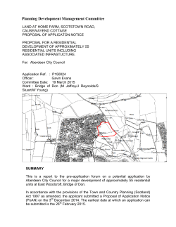


© Copyright 2026