
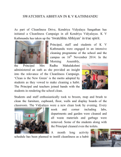
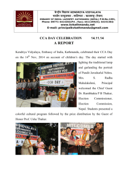
Open spaces
PREPAREDNESS / CONTINGENCY PLANNING
Planned Temporary Displacement Sites / Open Spaces
As a part of the CCCM cluster’s contingency plan, and in preparation for the upcoming
monsoon season, Site Planning has taken the lead on conducting land suitability assessment
in order to identify engineering measures/site preparations needed for developing safe
temporary displacement sites in accordance with universal minimum standards in life-saving
areas of humanitarian response.
The Ministry of Home Affairs (MOHA) has requested CCCM to be ready for any eventual
need for the management of future temporary displacements sites. CCCM considers this to
include the development of planned temporary displacement sites. A government decision
regarding the activation of any such sites is still pending.
Further to this and according to the National Human Rights Commission (NHRC) an
estimated number of 10,000 IDPs are expected to come to Kathmandu from surrounding
districts before the monsoon season. In order to facilitate for people to settle closer to their
place of origin and to avoid a population influx to Kathmandu, it is important to provide
alternatives for IDPs in the districts.
Situation in Kathmandu Valley
In Kathmandu Valley, 83 evacuation sites were selected as a part of the Open Space Concept,
initiated in 2009 following the Koshi Flood Response and the activation of the cluster
approach in Nepal.
These identified sites are yet to be assigned a humanitarian purpose following the disaster
event. Each open space has been allocated with suggested applications to accommodate for
the projected needs following a disastrous event in the Kathmandu Valley.
The Open Spaces were never designed to provide a full response/reception capability for all
displacement in the Kathmandu Valley following an earthquake. The Open Spaces are
designed to provide the initial response planning framework for the Government and partner
agencies to be able to have a starting point from which to provide life-saving assistance to
those in immediate need. Site Planning has focused on the 16 sites identified by the
government for immediate displacement after the earthquake of 25 April.
Note that these sites where initially meant as evacuation sites, and are not suitable as
temporary displacement sites unless engineering measures are taken – specified in reports
that will be published shortly.
1
SITUATION IN SINDHUPALCHOK
OKHALDHUGA / GORKHA
/
DOLAKHA
/
RAMECHHAP
/
In order to identify potential locations for temporary displacement sites, an initial mapping
was carried out by The Disaster Assistance Response Team (DART) of the Canadian
Military, and CCCM DTM and Site Planning, by using GIS and other mapping tools. The
identification of potential sites was based on the following criteria:
-
The site has less than 5 degrees of slope (landslide and flooding hazards)
Road access in close proximity (access to provision of services)
The site is close to one or more existing settlements
Minimum lot size 2000m2 (Sindhupalchowk) / 6000 m2 (other districts)
A minimum distance of 25m from streams ( flooding hazards)
670 sites where identified in these five districts. Land suitability assessments will be
conducted in up to five in each district. Partner are being identified.
IMPORTANT NOTE: The final selection of potential sites will be done after submerging
maps of identified locations with an overall environmental hazard mapping e.g.: landslides;
seasonal flooding. Data will be provided by The Nepal Risk Reduction Consortium (NRRC)
or other relevant partners.
Site Planning is currently calculating costs, manpower needed, CFW options and timeframe
for the locations that have already been assessed in Kathmandu Valley and Sindhupalchowk.
2


© Copyright 2026