
Go with the Flow: Curtis Prairie Self-Guided Walk
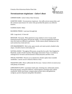
Prairie
G4
G1
Longenecker Gardens
J1
G2 G3
M3
A3
B3
ods
E8
F1
A6
C4
D8
Leopold
Pines
C6
Curtis B5
Pond B6
“Go with the flow:”
A self-guided walk
through Curtis Prairie
L8
L3
L4
L6
Pond 2
B2
A8
Stormwater
Management
Research
Facility
Curtis Prairie
Coyote
Pond
B7
A9
D5
West Beltline (Hwy 12/18)
Pedestrian Tunnel
0
Martin St. Lot
Southeast Marsh
F2
Teal Pond
Wetlands
A5
C1
B4
D7
A7
F5
Teal
Juniper
Pond
Knoll F3
B1
E2
E6
Lost City Forest
L5
Curtis Lot
C3
J2
F6
F4
A4
Arboretum Visitor Center
Main Parking Area
E5
F7
Native Plant
Garden
leaflet 24, February 2012
500
1000
1500
feet
Community types
Bike Route
Horticulture
Wheelchair Accessible
Coniferous forest
Boardwalk
Deciduous forest
Council Ring
Savanna
Parking
Prairie
Wetlands
Open water
Buffer zone
W
ater flows downhill, of course, and so does the main trail through the
“world’s oldest ecologically-restored prairie.” This guide describes the
path that water takes as it flows from an urban watershed of some 144 acres,
where rainfall that cannot soak into the ground runs off rooftops, sidewalks
and driveways--and collects in gutters that flow downhill toward Curtis
Prairie. When the water approaches the Beltline Highway, it goes through a
large culvert and into a broken, concrete flume, which carries the water and
the contaminants it has gathered into a stormwater retention pond, called
Curtis Pond. From there, the water flows onto the prairie through metal and
concrete structures, along an eroded creek, and across a sedge meadow, exiting
through the eastern culvert (Map A).
Our purpose in inviting visitors to walk this path is to explain how urban
runoff sustains wetland vegetation but also brings in contaminants; we also
explain how the wetland improves water quality by absorbing, denaturing
and removing contaminants. This reciprocal relationship complicates the
Arboretum’s need to follow rules about managing both runoff and prairie
vegetation.
Prior to urbanization, none of the watershed had streets, sidewalks, or
roofs (“hardscaping”), as rain and melting snow infiltrated into the soil well
upstream of Curtis Prairie. There was no pond and no creek in Curtis Prairie.
As runoff increased in quantity and decreased in quality, however, UW
responded by excavating “Curtis Pond” in ~1979. Now, the Department of
Natural Resources requires that UW “maintain” the pond. It is unclear how
best to do so. How can the Arboretum reap the benefit of stormwater (which
sustains wetlands in Curtis Prairie) while avoiding its hazards (unwanted
contaminants)? Arboretum conservationists hope to minimize the use of
engineered structures and maximize environmentally-friendly approaches.
Ma
1
Park at the Curtis Prairie lot and bring the beautiful Prairie Plants book,
which describes ~230 plants that live in Arboretum prairies. The book is
available at the Visitor Center. The map in this leaflet shows locations of posts.
call constructed impoundments “magnets for invasive species”, including
tiny aquatic animals.
hhStormwater regulators are asking UW to re-dredge Curtis Pond to ~7.5
feet, because it no longer has the capacity to accept sediments that might
accompany future storms. Conservationists at the Arboretum hope for
minimum disturbance because (1) every construction project has unintended
negative impacts (see Leaflet 23); (2) valuable nutrient-removal functions
are provided by the shallow water and the small cattail marsh that formed
where runoff enters the pond; (3) disturbance invites weeds to invade; and
(4) the proposed modifications emphasize water control, not facilitation of
processes that are critical to Curtis Prairie.
hhStormwater has altered Curtis Prairie by expanding wetland habitat. Now
that the prairie has a large wetland, it is neither necessary nor beneficial
to eliminate urban runoff. It is, however, a high priority to continue weed
control using approaches that conserve ecosystem services.
2
Walk across the road to the “Curtis Prairie rock” (post C1) and then turn
left and take the fire lane east until you see the intersection (post B4) with
a north-south fire lane. Turn right toward the Beltline on the fire lane. Note the
topography—you are heading downhill to the lowest point along the fire lane,
where you see a large box culvert pipe and water exiting Curtis Pond. The box
culvert was installed in 2010 after an earlier culvert washed out.
hhThe prairie’s 144-acre urban watershed discharges more water today than
when it was rural. Urban runoff is highly “pulsed” because of extensive
hardscaping.
3
Continue south upslope toward the Beltline until you see Curtis Pond just
inside a berm to the west. The pond was created by excavating sediments
from the prairie. The goal was to collect incoming sediments from stormwater,
which it did. Within 2-3 years, the new sediments had to be removed.
hhThe sediments were not trucked off-site but were piled in a long mound
southeast of the pond. Weeds established, and reed canary grass (Phalaris
arundinacea) crowded out native plants. Reed canary grass is Wisconsin’s
worst wetland weed, a distinction it earned by dominating ~500,000 acres
of historical wetlands. Invasion by weeds is a typical unintended negative
impact of construction projects (Leaflet 23).
hhAs you view the pond, make note of any birds or signs of wildlife.
Stormwater ponds do not attract many native species. Limnologists at UW
hhIn water sampling during 2011, we found higher concentrations of nutrients
in the water entering Curtis Pond than in its outflow.
4
Keep walking south along the chain-link fence that protects visitors from
falling onto the remains of a concrete flume designed to carry runoff into
Curtis Pond. When tree and shrub leaves are dense, the damaged flume is hard to
see. The flooding of 1996 broke up the concrete, eroded the channel, and created a
gully in, around, and under the concrete.
hhArboretum conservationists would like the flume to be replaced with a buried
pipe, with native vegetation planted over the pipe and with minimal damage
to the marsh at the south end of Curtis Pond.
hhCattails in shallow water have underground stems and roots that leak
oxygen into the soil, creating ideal conditions for “denitrifying” bacteria to
convert harmful nitrates to harmless nitrogen gas (air). Cattail marshes are
extremely effective at nitrogen removal, an ecosystem service that protects
downstream wetlands and waters.
hhMost stormwater treatment facilities are designed for sediment and
phosphorus removal; this makes sense when the resource to be protected is a
lake where adding phosphorus will cause algae to proliferate. But Curtis Pond
is 1.4 miles upstream from Lake Wingra and the needs of wetlands between
the Beltline and Lake Wingra should have priority for protection. If nitrogen
is not removed by Curtis Pond, more weeds can be expected downstream. A
priority for Curtis Pond should be to maintain its ability to remove nitrogen.
5
Make a U-turn and walk north again. Note that the berm supports native
plants and a few persistent weeds, such as leafy spurge. Conservationists
would make the pond edge more uneven, more able to remove nitrogen, and more
friendly to wildlife, with minimal impact and low risk of further weedy invasions.
Perhaps you have more ideas to share!
6
A side trip along a short loop trail (post B7) around the “limestone prairie”
offers a great view of Curtis Prairie toward the east. The land slopes
gently toward the center, with wetland where the topography is flatter. Over
centuries, sediments moved downslope, accumulating until the ground became
level and water slowed its flow and spread more broadly. The resulting habitat
favors wetland plants, which are highly productive, create microtopographic
depressions, and trap inflowing water.
hhThere is a positive feedback, with water facilitating wetland vegetation that
acts as a sponge for water.
will contain the reed canary grass, an effort that is less damaging than
structures such as a graded, bermed channel.
9
While standing on the boardwalk, look to the east for evidence of herbivory
on reed canary grass. If you see a patch of stubble, see if the grass stems
have been cut at a 45° angle. This is the “signature” of rabbits. Wouldn’t it be great
if native herbivores would help us control an invasive weed!
10
Return to the main trail and proceed downstream (east) to two more
boardwalk bridges. Note that Curtis Creek splits into two forks. A map of
reed canary grass shows that the infestation is limited to the edges of the forks,
offering encouragement that selective herbiciding could control this plant. A
graded channel, in contrast, would only create more habitat for weeds.
7
At post B5, take the trail east, downslope and parallel to Curtis Creek,
which formed after stormwater was trapped by the pond and its outflow was
restricted to a “point source discharge,”. Forcing the surface flow into a culvert
allowed the water to erode a creek that now extends half way through Curtis
Prairie.
8
Walk east on the trail and take a side trip to the left at post B2. You can
cross Curtis Creek on the boardwalk and look west to view the 2000-sqyard area that became dominated by reed canary grass in response to stormwater
ponding. Just why stormwater ponds there is a matter of debate, but scientists
hypothesize that excess water carrying road salts washed fine soil particles
through the surface soil and deposited a thin layer of clay at about 2.5 feet depth.
That clay layer impounds runoff.
hhInvasion by reed canary grass is an unintended negative impact of excess
water inflows. Confining stormwater to a point-source discharge also created
a creek with bare banks where this weedy grass could establish and spread.
hhThis same area supported important research on a control method for reed
canary grass. In a 3-year study, a herbicide temporarily stunted but did
not kill the invader. However, the stunting did allow several native species
seeded by researchers to establish and spread. Continued spot herbiciding
11
Continuing along the trail, you walk through a mixture of prairie grasses
and forbs until you approach a stand of sandbar willows (Salix exigua).
Just before you reach the willows, the trail comes very close to the wetland,
where our native Canada bluejoint grass (Calamagrostis canadensis) occurs just
south of the trail.
hhOur research shows that nutrient-rich wetlands are dominated by just a few
species, and we are working to determine why this is the case. Possibilities
are that a few species are “superplants” that outcompete others, or that only
a few seeds of native plants reach the site, or that herbivores or plant diseases
attack native seedlings.
12
Just north of the trail is a monitoring station where temperature and
carbon dioxide data help us track carbon storage in the soil. The restored
prairie is storing carbon but it has not yet caught up to the wetter prairie remnant
to the east. The eastern part of Curtis Prairie was never plowed, and its soil stores
carbon as undecomposed organic matter. In contrast, the rest of the prairie was
plowed, which exposed soil organic matter to the air, where it was easily oxidized
to carbon dioxide (a greenhouse gas).
15
hhAn important benefit of stormwater inflow is the increased area of wet soil
and Curtis Prairie’s increased capacity to store carbon.
hhThe nutrient content of flowing water at this point is low compared to that
upstream. Curtis Prairie cleans stormwater effectively, and any construction
projects that would alter this ecosystem service should undergo strong,
science-based evaluation.
As you walk next to the willows, note that there is little vegetation under them.
The willows produce dense shade, excluding grasses and forbs. The lack of grass
“fuel” in the understory explains why control burns do not carry well. As a
result, willows have expanded substantially over the past decade, and our field
staff needs to use herbicides to control them.
hhWoody invaders reduce grass cover, and grass cover reduces the ability of fire
to control woody invasions in a negative feedback relationship.
13
Cross the fire lane at post
A6 and continue walking
east at A5 through the unplowed
portion of Curtis Prairie. It is a true
privilege to experience a remnant
prairie of such high quality.
hhThe most species-rich vegetation
in all of Curtis Prairie occurs in
this unplowed remnant.
14
Turn right (south) when you reach the easternmost fire lane of Curtis
Prairie. Note the wet soil west of the fire lane. The raised fire lane
impounds water that would otherwise flow east. Willows grow well in standing
water. To the east, you also see cattails (Typha latifolia), Canada bluejoint and
tussock sedge (Carex stricta).
hhNative cattail allows native plants to co-exist, by being less dense than
invasive hybrid cattails. In this spot, it is likely that denitrification combats
eutrophication, so that cattails do not outgrow other species.
Just before the fire lane curves eastward, you encounter a culvert,
where stormwater exits Curtis Prairie. Compare the size of this small
culvert to the large box culvert upstream. Water that rushes out of Curtis Pond
is greatly modified both in quantity and quality by its trip through the prairie.
Some water infiltrates, some evaporates, and some is taken up by plants. Some of
the nutrients are taken up by plants, and some nitrogen is returned to the air as
harmless nitrogen gas.
16
If you continue south (toward post A8), you will find a path leading to
the Stormwater Management Research Facility discussed in Leaflet #23.
17
Alternatively, make a U-turn and walk from post A7 to F1 to F2 toward
Teal Pond (F3), a natural pond that receives inflows of water from the
entire Curtis Prairie watershed.
hhAlong your walk, you have seen where urban runoff sustains wetland
vegetation, and where water samples show that the resulting wetland
improves water quality. The potential mechanisms for “improvement”
include absorbing, denaturing and removing contaminants; these
mechanisms are yet to be determined.
Although it is difficult to manage both the runoff and the prairie, Arboretum
conservationists aim (1) to accommodate existing urban runoff so that the
wetlands can continue to improve the quality of through-flowing water and (2) to
manage Curtis Pond so that it can remove nitrogen and make it easer to control
reed canary grass.
References to research can be found at
uwarboretum.org
(see menu for “Scientific Papers”).
This Leaflet was compiled by Joy Zedler,
with help from Madeline Fisher, Roberto
Lindig-Cisneros, Joy Rifkin, Isabel Rojas
Viada, Bonnie Svarstad, James Doherty,
and Paul Zedler. Layout by Sarah Friedrich.


© Copyright 2026