
1344155 COVER SHEET FOR PROPOSAL TO THE NATIONAL SCIENCE FOUNDATION NSF 13-1
COVER SHEET FOR PROPOSAL TO THE NATIONAL SCIENCE FOUNDATION
PROGRAM ANNOUNCEMENT/SOLICITATION NO./CLOSING DATE/if not in response to a program announcement/solicitation enter NSF 13-1
FOR NSF USE ONLY
NSF PROPOSAL NUMBER
NSF 13-1
FOR CONSIDERATION BY NSF ORGANIZATION UNIT(S)
1344155
(Indicate the most specific unit known, i.e. program, division, etc.)
AGS - COMPUTING FACILITIES
DATE RECEIVED NUMBER OF COPIES DIVISION ASSIGNED FUND CODE DUNS#
05/28/2013
1
06020000 AGS
EMPLOYER IDENTIFICATION NUMBER (EIN) OR
TAXPAYER IDENTIFICATION NUMBER (TIN)
840412668
1520
FILE LOCATION
(Data Universal Numbering System)
078339587
05/28/2013 9:25pm
IS THIS PROPOSAL BEING SUBMITTED TO ANOTHER FEDERAL
AGENCY?
YES
NO
IF YES, LIST ACRONYM(S)
SHOW PREVIOUS AWARD NO. IF THIS IS
A RENEWAL
AN ACCOMPLISHMENT-BASED RENEWAL
0833450
NAME OF ORGANIZATION TO WHICH AWARD SHOULD BE MADE
ADDRESS OF AWARDEE ORGANIZATION, INCLUDING 9 DIGIT ZIP CODE
BOULDER, CO 803055602
US
University Corporation For Atmospheric Res
AWARDEE ORGANIZATION CODE (IF KNOWN)
4062600000
NAME OF PRIMARY PLACE OF PERF
ADDRESS OF PRIMARY PLACE OF PERF, INCLUDING 9 DIGIT ZIP CODE
University Corporation For Atmospheric Res
1850 Table Mesa Dr
Boulder ,CO ,803055602 ,US.
University Corporation For Atmospheric Res
IS AWARDEE ORGANIZATION (Check All That Apply)
(See GPG II.C For Definitions)
TITLE OF PROPOSED PROJECT
MINORITY BUSINESS
IF THIS IS A PRELIMINARY PROPOSAL
WOMAN-OWNED BUSINESS THEN CHECK HERE
Unidata 2018: Transforming Geoscience through Innovative Data
Services
REQUESTED AMOUNT
$
SMALL BUSINESS
FOR-PROFIT ORGANIZATION
PROPOSED DURATION (1-60 MONTHS)
24,438,924
60
REQUESTED STARTING DATE
12/01/13
months
SHOW RELATED PRELIMINARY PROPOSAL NO.
IF APPLICABLE
CHECK APPROPRIATE BOX(ES) IF THIS PROPOSAL INCLUDES ANY OF THE ITEMS LISTED BELOW
BEGINNING INVESTIGATOR (GPG I.G.2)
HUMAN SUBJECTS (GPG II.D.7) Human Subjects Assurance Number
DISCLOSURE OF LOBBYING ACTIVITIES (GPG II.C.1.e)
Exemption Subsection
PROPRIETARY & PRIVILEGED INFORMATION (GPG I.D, II.C.1.d)
INTERNATIONAL COOPERATIVE ACTIVITIES: COUNTRY/COUNTRIES INVOLVED
HISTORIC PLACES (GPG II.C.2.j)
(GPG II.C.2.j)
EAGER* (GPG II.D.2)
or IRB App. Date
RAPID** (GPG II.D.1)
VERTEBRATE ANIMALS (GPG II.D.6) IACUC App. Date
PHS Animal Welfare Assurance Number
PI/PD DEPARTMENT
PI/PD POSTAL ADDRESS
Unidata Program Center
P.O. Box 3000
Boulder, CO 80301
United States
UCAR Community Programs
PI/PD FAX NUMBER
303-497-8690
NAMES (TYPED)
High Degree
Yr of Degree
Telephone Number
PhD
1986
303-497-8661
Email Address
PI/PD NAME
Mohan K Ramamurthy
CO-PI/PD
CO-PI/PD
CO-PI/PD
CO-PI/PD
Page 1 of 3
[email protected]
CERTIFICATION PAGE
Certification for Authorized Organizational Representative (or Equivalent) or Individual Applicant
By electronically signing and submitting this proposal, the Authorized Organizational Representative (AOR) or Individual Applicant is: (1) certifying that statements made herein are true and
complete to the best of his/her knowledge; and (2) agreeing to accept the obligation to comply with NSF award terms and conditions if an award is made as a result of this application. Further,
the applicant is hereby providing certifications regarding conflict of interest (when applicable), drug-free workplace, debarment and suspension, lobbying activities (see below),
nondiscrimination, flood hazard insurance (when applicable), responsible conduct of research, organizational support, Federal tax obligations, unpaid Federal tax liability, and criminal
convictions as set forth in the NSF Proposal & Award Policies & Procedures Guide,Part I: the Grant Proposal Guide (GPG). Willful provision of false information in this application and its
supporting documents or in reports required under an ensuing award is a criminal offense (U.S. Code, Title 18, Section 1001).
Conflict of Interest Certification
When the proposing organization employs more than fifty persons, the Authorized Organizational Representative (or equivalent) is required to complete the following certification regarding
Conflict of Interest:
By electronically signing the Certification Pages, the Authorized Organizational Representative (or equivalent) is certifying that the organization has implemented a written and enforced
conflict of interest policy that is consistent with the provisions of the NSF Proposal & Award Policies & Procedures Guide, Part II, Award & Administration Guide (AAG) Section IV.A;
that to the best of his/her knowledge, all financial disclosures required by that conflict of interest policy have been made; and that all identified conflicts of interest will have been satisfactorily
managed, reduced or eliminated prior to the organization’s expenditure of any funds under the award, in accordance with the organization’s conflict of interest policy. Conflicts which cannot
be satisfactorily managed, reduced or eliminated must be disclosed to NSF.
Drug Free Work Place Certification
By electronically signing the Certification Pages, the Authorized Organizational Representative (or equivalent), is providing the Drug Free Work Place Certification contained in
Exhibit II-3 of the Grant Proposal Guide.
Debarment and Suspension Certification
(If answer "yes", please provide explanation.)
Is the organization or its principals presently debarred, suspended, proposed for debarment, declared ineligible, or voluntarily excluded
from covered transactions by any Federal department or agency?
Yes
No
By electronically signing the Certification Pages, the Authorized Organizational Representative (or equivalent) or Individual Applicant is providing the
Debarment and Suspension Certification contained in Exhibit II-4 of the Grant Proposal Guide.
Certification Regarding Lobbying
This certification is required for an award of a Federal contract, grant, or cooperative agreement exceeding $100,000 and for an award of a Federal loan or a commitment providing
for the United States to insure or guarantee a loan exceeding $150,000.
Certification for Contracts, Grants, Loans and Cooperative Agreements
The undersigned certifies, to the best of his or her knowledge and belief, that:
(1) No Federal appropriated funds have been paid or will be paid, by or on behalf of the undersigned, to any person for influencing or attempting to influence an officer or employee of any
agency, a Member of Congress, an officer or employee of Congress, or an employee of a Member of Congress in connection with the awarding of any Federal contract, the making of any
Federal grant, the making of any Federal loan, the entering into of any cooperative agreement, and the extension, continuation, renewal, amendment, or modification of any Federal
contract, grant, loan, or cooperative agreement.
(2) If any funds other than Federal appropriated funds have been paid or will be paid to any person for influencing or attempting to influence an officer or employee of any agency, a
Member of Congress, an officer or employee of Congress, or an employee of a Member of Congress in connection with this Federal contract, grant, loan, or cooperative agreement, the
undersigned shall complete and submit Standard Form-LLL, ‘‘Disclosure of Lobbying Activities,’’ in accordance with its instructions.
(3) The undersigned shall require that the language of this certification be included in the award documents for all subawards at all tiers including subcontracts, subgrants, and contracts
under grants, loans, and cooperative agreements and that all subrecipients shall certify and disclose accordingly.
This certification is a material representation of fact upon which reliance was placed when this transaction was made or entered into. Submission of this certification is a prerequisite for
making or entering into this transaction imposed by section 1352, Title 31, U.S. Code. Any person who fails to file the required certification shall be subject to a civil penalty of not less
than $10,000 and not more than $100,000 for each such failure.
Certification Regarding Nondiscrimination
By electronically signing the Certification Pages, the Authorized Organizational Representative (or equivalent) is providing the Certification Regarding
Nondiscrimination contained in Exhibit II-6 of the Grant Proposal Guide.
Certification Regarding Flood Hazard Insurance
Two sections of the National Flood Insurance Act of 1968 (42 USC §4012a and §4106) bar Federal agencies from giving financial assistance for acquisition or
construction purposes in any area identified by the Federal Emergency Management Agency (FEMA) as having special flood hazards unless the:
(1) community in which that area is located participates in the national flood insurance program; and
(2) building (and any related equipment) is covered by adequate flood insurance.
By electronically signing the Certification Pages, the Authorized Organizational Representative (or equivalent) or Individual Applicant located in FEMA-designated special flood hazard areas is
certifying that adequate flood insurance has been or will be obtained in the following situations:
(1) for NSF grants for the construction of a building or facility, regardless of the dollar amount of the grant; and
(2) for other NSF grants when more than $25,000 has been budgeted in the proposal for repair, alteration or improvement (construction) of a building or facility.
Certification Regarding Responsible Conduct of Research (RCR)
(This certification is not applicable to proposals for conferences, symposia, and workshops.)
By electronically signing the Certification Pages, the Authorized Organizational Representative is certifying that, in accordance with the NSF Proposal
& Award Policies & Procedures Guide, Part II, Award & Administration Guide (AAG) Chapter IV.B., the institution has a plan in place to provide appropriate training and oversight in the
responsible and ethical conduct of research to undergraduates, graduate students and postdoctoral researchers who will be supported by NSF to conduct research.
The AOR shall require that the language of this certification be included in any award documents for all subawards at all tiers.
Page 2 of 3
CERTIFICATION PAGE - CONTINUED
Certification Regarding Organizational Support
By electronically signing the Certification Pages, the Authorized Organizational Representative (or equivalent) is certifying that there is organizational support for the proposal as required by
Section 526 of the America COMPETES Reauthorization Act of 2010. This support extends to the portion of the proposal developed to satisfy the Broader Impacts Review Criterion as well as
the Intellectual Merit Review Criterion, and any additional review criteria specified in the solicitation. Organizational support will be made available, as described in the proposal, in order to
address the broader impacts and intellectual merit activities to be undertaken.
Certification Regarding Federal Tax Obligations
When the proposal exceeds $5,000,000, the Authorized Organizational Representative (or equivalent) is required to complete the following certification regarding Federal tax obligations.
By electronically signing the Certification pages, the Authorized Organizational Representative is certifying that, to the best of their knowledge and belief, the proposing organization:
(1) has filed all Federal tax returns required during the three years preceding this certification;
(2) has not been convicted of a criminal offense under the Internal Revenue Code of 1986; and
(3) has not, more than 90 days prior to this certification, been notified of any unpaid Federal tax assessment for which the liability remains unsatisfied, unless the assessment is the
subject of an installment agreement or offer in compromise that has been approved by the Internal Revenue Service and is not in default, or the assessment is the subject of a non-frivolous
administrative or judicial proceeding.
Certification Regarding Unpaid Federal Tax Liability
When the proposing organization is a corporation, the Authorized Organizational Representative (or equivalent) is required to complete the following certification regarding Federal Tax
Liability:
By electronically signing the Certification Pages, the Authorized Organizational Representative (or equivalent) is certifying that the corporation has no unpaid Federal tax liability that has
been assessed, for which all judicial and administrative remedies have been exhausted or lapsed, and that is not being paid in a timely manner pursuant to an agreement with the authority
responsible for collecting the tax liability.
Certification Regarding Criminal Convictions
When the proposing organization is a corporation, the Authorized Organizational Representative (or equivalent) is required to complete the following certification regarding Criminal
Convictions:
By electronically signing the Certification Pages, the Authorized Organizational Representative (or equivalent) is certifying that the corporation has not been convicted of a felony criminal
violation under any Federal law within the 24 months preceding the date on which the certification is signed.
AUTHORIZED ORGANIZATIONAL REPRESENTATIVE
SIGNATURE
DATE
NAME
Lori LaFon
TELEPHONE NUMBER
303-497-2143
Electronic Signature
EMAIL ADDRESS
May 28 2013 6:40PM
FAX NUMBER
[email protected]
fm1207rrs-07
* EAGER - EArly-concept Grants for Exploratory Research
** RAPID - Grants for Rapid Response Research
Page 3 of 3
PROJECT SUMMARY
Overview:
Unidata is a community data facility for the atmospheric and related sciences, established
in 1984 by U.S. universities with sponsorship from the National Science Foundation. While
its founding mission -- making atmospheric science data available to university departments
in near real time -- has remained central to Unidata’s activities, Unidata’s field of endeavor
has grown to encompass a wide range of cyberinfrastructure technologies that make geoscience
data more useful and easier for scientists and educators to access. Similarly, Unidata’s member
community has grown to include over 700 U.S. universities and colleges, forming a solid core
of the more than 3000 educational, government, and research institutions that rely on Unidata
technologies worldwide.
Intellectual Merit :
In this proposal, we have identified four strategic goals: enabling efficient access to geoscience
data, developing tools for effective use of geoscience data, providing community leadership
on geoscience cyberinfrastructure issues, and building and supporting a diverse geoscience
community. This plan extends the work Unidata has done, addressing emerging issues related
to ever-growing data volumes, complexity of data-centric scientific workflows, and IT resource
constraints at our member universities.
Our approach to address these issues leverages the advantages of the robust cloud-based computing
environments that have emerged in recent years. We plan to evolve and augment existing Unidata
technologies with the goals of:
* Reducing the amount of data that must be transferred over computer networks,
* Reducing the complexity of the hardware and software environments our community members
must maintain, while
* Increasing the flexibility of investigators to conduct science and extract knowledge from
the deluge of geoscience data.
Through these efforts, Unidata will empower its users to tackle multidisciplinary grand challenge
problems, develop the profession’s human capacity, and transform the conduct of science.
Broader Impacts :
Although Unidata’s core activities focus on serving scientists and educators in the atmospheric
and related sciences, virtually every project Unidata undertakes has a broader impact on the
geosciences community and society at large. Among the many examples:
* Unidata’s impact on research is evidenced by references to Unidata software and services
in more than 1100 scholarly articles in the past 5 years alone. Such impact is expected to
continue.
* In education, Unidata has worked to encourage participation by a diverse array of academic
institutions beyond its traditional constituency of universities granting degrees in the atmospheric
sciences. Over 100,000 students in U.S. colleges and universities from all 31 EPSCoR states
and numerous HACU and HBCU institutions are expected to use Unidata’s products and services.
* Unidata-developed cyberinfrastructure will continue to be in wide use among U.S. federal
agencies, private industry, and non-governmental and international organizations including
NOAA, NWS, NASA, USGS, DOE, DOD, ECMWF, EUMETSAT, CMA, and CPTEC.
* Unidata undertakes a variety of activities with the goal of building a vibrant community
in the geosciences and beyond, including mentoring undergraduate students at the Unidata Program
Center, holding community workshops and attending scientific meetings, and participating in
large-scale community projects such as OGC’s GALEON and NSF’s EarthCube. These collaborative
efforts will be sustained during the next five years.
Page A
TABLE OF CONTENTS
For font size and page formatting specifications, see GPG section II.B.2.
Total No. of
Pages
Page No.*
(Optional)*
Cover Sheet for Proposal to the National Science Foundation
Project Summary
(not to exceed 1 page)
1
Table of Contents
1
Project Description (Including Results from Prior
NSF Support) (not to exceed 15 pages) (Exceed only if allowed by a
specific program announcement/solicitation or if approved in
advance by the appropriate NSF Assistant Director or designee)
25
References Cited
1
Biographical Sketches
(Not to exceed 2 pages each)
Budget
7
15
(Plus up to 3 pages of budget justification)
Current and Pending Support
5
Facilities, Equipment and Other Resources
1
Special Information/Supplementary Documents
(Data Management Plan, Mentoring Plan
and Other Supplementary Documents)
28
Appendix (List below. )
(Include only if allowed by a specific program announcement/
solicitation or if approved in advance by the appropriate NSF
Assistant Director or designee)
Appendix Items:
*Proposers may select any numbering mechanism for the proposal. The entire proposal however, must be paginated.
Complete both columns only if the proposal is numbered consecutively.
Unidata 2018: Transforming Geoscience through
Innovative Data Services
Data are the lifeblood of the geosciences. Rapid advances in computing, communications, and
observational technologies — along with concomitant advances in high-resolution modeling, ensemble
and coupled-systems predictions of the Earth system — are revolutionizing nearly every aspect of our
field. The result is a dramatic proliferation of data from diverse sources; data that are consumed by an
evolving and ever-broadening community of users and that are becoming the principal engine for driving
scientific advances. Data-enabled research has emerged as a Fourth Paradigm of science, alongside
experiments, theoretical studies, and computer simulations (Hey et al., 2010).
For more than a quarter century, Unidata has worked in concert with the atmospheric science education
and research community to develop and provide innovative data systems, tools, techniques, and resources
to support data-enabled science to understand the Earth system. In doing so, Unidata has maintained a
close, synergistic relationship with the universities, engaging them in collaborative efforts to exploit data
and technologies, and removing roadblocks to data discovery, access, analysis, and effective use.
Unidata’s long experience helping geoscientists incorporate data-centric techniques into their scientific
workflows positions us perfectly to help our community take advantage of a rapidly changing scientific
landscape. Science is shifting in emphasis from pure disciplinary research to a more balanced mix that
advances disciplinary knowledge while looking to apply research results to interdisciplinary “grand
challenge” problems touching both science and society. Unidata is in an ideal position to adapt to and
capitalize on the rapid advances in information technology that will enable the community to incorporate
the dramatic explosion of data volumes into their research and education programs. This will ensure that
the next generation of students and young researchers in the Unidata community become leaders using
state-of-the-art tools, technologies, and techniques.
Unidata’s community expects it to both lead through innovation and follow the community’s direction by
being responsive to its changing needs. We welcome these challenges, viewing them as opportunities to
enhance our community’s ability to work together to create knowledge, while recognizing that our own
ability to adapt and change as new technologies emerge is crucial to our continued success.
To that end, this proposal charts a course for the next five years, laying out our plans for sustaining and
enhancing the Unidata program. While the goals and the action plan articulated here are consistent with
and in furtherance of the National Science Foundation’s vision and goals to transform the conduct of
science, it provides a specific vision in which community members are empowered to tackle emerging
data-related scientific and educational problems in more innovative, efficient, and productive ways.
Achieving the goals in this proposal will bring our community closer to the vision of geoscience at the
speed of thought articulated in our strategic plan, dramatically reversing today’s situation in which young
researchers spend 80 percent of their time performing data-related tasks and only 20 percent “doing
meaningful science.” Through the proposed activities and concrete steps described here, Unidata commits
to work toward enabling that transformation.
Who We Are and What We Do
Unidata (http://www.unidata.ucar.edu) is a community data facility for the atmospheric and related
sciences, established in 1984 by U.S. universities with sponsorship from the National Science Foundation
(NSF). The Unidata Program Center (UPC), the program office for Unidata and the nexus of activities
related to Unidata’s mission, is managed by the University Corporation for Atmospheric Research
(UCAR), a consortium of over 104 member universities and academic affiliates providing science in
service to society.
Unidata 2018
1
Unidata exists to engage and serve researchers and educators dedicated to advancing the frontiers of Earth
System science. The program’s aim is to help transform the conduct of research and education in
atmospheric and related sciences by providing well-integrated, end-to-end data services and tools that
address many aspects of the scientific data lifecycle, from locating and retrieving useful data, through the
process of analyzing and visualizing data either locally or remotely, to curating and sharing the results.
Specifically, the UPC:
x Acquires, distributes, and provides remote access to real-time meteorological data.
x Develops software for accessing, managing, analyzing, visualizing, and effectively using
geoscience data.
x Provides comprehensive training and support to users of its products and services.
x In partnership with others, facilitates the advancement of tools, standards and conventions.
x Provides leadership in cyberinfrastructure and fosters adoption of new tools and techniques.
x Assesses and responds to community needs, fostering community interaction and engagement to
promote sharing of data, tools, and ideas.
x Advocates on behalf of the community on data matters, negotiating data and software agreements.
x Grants equipment awards to universities to enable and enhance participation in Unidata.
Unidata is governed by its community. Representatives from universities populate standing and ad hoc
committees that set policies for the program, provide first-hand feedback from users of program software
and services, and offer guidance on individual projects. Non-voting representatives from government
agencies also provide valuable information and advice. Unidata’s governance structure ensures that the
program stays in tune with the community it serves, and allows it to quickly adjust program priorities as
the technological landscape and community needs change.
While Unidata’s primary mission of serving universities engaged in atmospheric science education and
research has remained unchanged through the years, the evolution and broad usefulness of its products and
services have greatly enlarged its initial user base. Today, the Unidata community includes users from all
sectors in over 200 countries, including nearly 2500 academic institutions and more than 80 research labs.
Simultaneously, Unidata’s activities and responsibilities have also grown as community needs have
evolved. Despite the growth in users and enhanced scope of its activities, according to a 2010 survey
conducted by the Unidata Users Committee, 97% of the respondents indicated that they were either
satisfied or highly satisfied with Unidata’s overall service to the community.
Last year, with community input and engagement of its governing committees, Unidata developed a
strategic plan (http://bit.ly/121cdE1), creating a roadmap and a vision for the future. The overarching goal
embodied in that plan is the creation of a scientific ecosystem in which “data friction” (Edwards, 2010) is
reduced and data transparency and ease-of-use are increased. In such an environment, scientists will
expend less effort locating, acquiring, and processing data and more time interpreting their data and
sharing knowledge.
To accomplish the goals set forth in our strategic plan, Unidata will continue to build and provide
infrastructure that makes it easy to discover, access, integrate and use data from disparate geoscience
disciplines, allowing investigators to perceive connections that today are obscured by incompatible data
formats or the mistaken impression that the data they need for their investigations do not exist. This
proposal serves as an implementation plan for accomplishing those goals, moving our community toward
the realization of our overarching vision.
Unidata 2018
2
Unidata Snapshot
The following tables provide a snapshot of the Unidata program in May 2013, with comparisons to
metrics from the previous NSF proposal (where available).
Table 1: Data Services
Institutions Participating in the IDD network1
Host machines on the IDD network1
Data streams in the IDD
Approximate volume of data ingested into the IDD
Volume of data pushed to IDD sites
Volume of data pulled via remote access protocols
Uptime of UPC data and support infrastructure
2008
170
460 (250 unique sites)
22
100 GB/day
2.7 TB/day
44.3 GB/day
Table 2: Software Package Downloads
GEMPAK
IDV
Local Data Manager
McIDAS
netCDF-C Libraries (includes FORTRAN, C++ support) 2
netCDF-Java Libraries (Common Data Model)
THREDDS Data Server
UDUNITS
Table 3: Workshops
Training Workshop Participants
Training Workshop Courses
Users Workshop Participants
Regional Workshop Participants
Table 4: Miscellaneous
Number of community members registered with Unidata
Number of countries where Unidata software and services are used
Number of academic institutions participating (U.S.)
Number of academic institutions participating (worldwide)
Number of organizations participating worldwide
Number of community electronic mail lists
User support e-mail transactions, 2008-2012
Number of Community Equipment Awards, 2008-2012
Average staff FTEs at the UPC, 2008-2012
2013
263
520 (232 unique sites)
34
315 GB/day
13 TB/day
659 GB/Day
99.96%
2008-2012
11,801
43,944
11,455
857
408,250
89,416
7,176
26,265
2003-2007
335
38
164
44
2008-2012
475
33
183
162
2013
44,231
214
743
2,495
3,032
58
21,388
30
25
1
These metrics are limited to sites of which Unidata is aware. Sites can use the LDM and participate in the IDD
without reporting statistics to the UPC; we suspect the number of unreported sites is large.
2
UPC source code downloads only. This number does not include downloads from repositories at the University of
Kyoto and on the Github site, or binary distributions available via package managers on UNIX-like systems.
Unidata 2018
3
Unidata Focus Activities
Unidata Program Center staff are involved in a wide variety of projects in support of the Unidata
community, including data distribution, software development, user support and training, and community
service and leadership activities. The activities undertaken by the UPC span years or decades and affect
thousands of users around the world. In a different context – without the unifying locus of the Unidata
program – one could imagine many of Unidata’s projects as candidates for NSF funding in their own
right. As it is, our projects are able to build on and leverage each other’s capabilities, advancing our
community’s goals more effectively as a result. The Plan of Action that follows describes how activities
in these areas will address Unidata’s strategic goals for the empowerment of its broad community.
Data Distribution
The UPC coordinates the Internet Data Distribution system (IDD), in which hundreds of universities
cooperate to disseminate near real-time earth observations via the Internet. While the “push” data services
provided by the IDD system are the backbone of Unidata’s data distribution services, the UPC also
provides on-demand “pull” data services via THREDDS, ADDE, and RAMADDA data servers.
The UPC’s data servers are not classified as “operational” resources, but they nonetheless have a 99.96%
uptime record and are used heavily by educational sites that lack the resources to store IDD-provided data
locally, or to operate their own data servers (see Table 1). UPC’s servers are housed in a UCAR colocation computer facility for reliability, and share UCAR’s Internet2/National Lambda Rail connectivity,
which provides access to ample bandwidth for Unidata’s needs.
Software Development
A variety of software packages are developed, maintained, and supported by the UPC:
NetCDF
Unidata’s netCDF (network Common Data Form) is a freely distributed collection of data access libraries
that provide a machine-independent data format that is self-describing, portable, scalable, appendable,
sharable, and archivable – all important qualities for those who wish to create, access, and share arrayoriented scientific data. NetCDF permits easy access to array-based, multi-dimensional datasets, a task
that can be difficult when using other common storage schemes. NetCDF has been adopted widely by the
atmospheric sciences community, and is especially popular among climate and ocean modelers. For
example, model output datasets for the Fifth Assessment Report of the Intergovernmental Panel on
Climate Change must be submitted in netCDF format, using the associated Climate and Forecast (CF)
metadata conventions. The resulting large base of netCDF users and data has led to support for the format
in more than 80 open source packages and many commercial applications including MATLAB and IDL.
Common Data Model & THREDDS Data Server
Unidata’s Common Data Model (CDM) provides an interface for reading and writing files in netCDF and
a variety of other scientific data formats. The CDM uses metadata to provide a high-level interface to
geoscience-specific features of datasets, including geolocation and data subsetting in coordinate space.
Unidata’s THREDDS Data Server (TDS) builds on the CDM to allow for browsing and accessing
collections of scientific data via electronic networks. Data published on a TDS are accessible through a
variety of remote data access protocols including OPeNDAP, OGC Web Map Service (WMS) and Web
Coverage Service (WCS), NetCDF Subset Service (NCSS), and HTTP.
The CDM and TDS are widely used in the United States (by NOAA, USGS, NASA, and the Earth
System Grid, for example) and internationally, and are part of the deep infrastructure on which next
generation capabilities are being built by other organizations. Additionally, many other tools build on the
Unidata 2018
4
CDM (NOAA’s ERDDAP, NASA’s Panoply, and CMAS’ VERDI, are examples) and on the TDS
(NOAA PMEL’s LAS and Ferret-TDS, for example).
Integrated Data Viewer
Unidata’s Integrated Data Viewer (IDV) is a 3D geoscience visualization and analysis tool that gives
users the ability to view and analyze a rich set of geoscience data in an integrated fashion. The IDV brings
together the ability to display and analyze satellite imagery, gridded data (such as numerical weather
prediction model output), surface observations (METARs), upper air soundings, NWS NEXRAD Level II
and Level III RADAR data, NOAA National Profiler Network data, and GIS data, all within a unified
interface. The IDV integrates tightly with common scientific data servers (including Unidata’s TDS) to
provide easy access to many real-time and archive datasets. It also provides collaborative features that
enable users to easily share their own data holdings and analysis products with others.
AWIPS II & GEMPAK
AWIPS II is a weather forecasting, display, and analysis package currently being developed by the NWS
and NCEP. Because many university meteorology programs are eager to use the same tools used by NWS
forecasters, Unidata community interest in AWIPS II is high. UPC staff have worked closely with NCEP
staff during AWIPS II development in order to devise a way to make it available to the university
community.
NCEP has stated that GEMPAK applications will be migrated from GEMPAK/NAWIPS into AWIPS II
for the National Centers. The UPC will likewise facilitate a migration from GEMPAK/NAWIPS to
AWIPS II for the university community.
Rosetta
The Rosetta project at the UPC is an effort to improve the quality and accessibility of observational data
sets collected via datalogging equipment. The initial goal of Rosetta is to transform unstructured ASCII
data files of the type commonly generated by datalogging equipment into the netCDF format, while
minimizing disruption to existing scientific workflows.
Local Data Manager
The Unidata Local Data Manager (LDM) system includes network client and server programs designed
for event-driven data distribution. It is the fundamental component of the IDD system. The LDM is used
by hundreds of sites worldwide, and is integrated into the National Weather Service’s AWIPS II package.
McIDAS
The Man-computer Interactive Data Access System (McIDAS) is a large, research-quality suite of
applications used for decoding, analyzing, and displaying meteorological data. The older McIDAS-X
system, developed by the University of Wisconsin’s Space Science Engineering Center and supported by
Unidata, is gradually being replaced by the IDV and by McIDAS-V (which is based on the IDV).
UDUNITS
Unidata’s UDUNITS supports conversion of unit specifications between formatted and binary forms,
arithmetic manipulation of units, and conversion of values between compatible scales of measurement.
RAMADDA
The Repository for Archiving, Managing and Accessing Diverse Data (RAMADDA) is a vibrant and
growing technology initially developed by Unidata and now managed and developed as an open source
project. Unidata integrates RAMADDA functionality into the IDV, provides training and support, and
contributes code to the project. In addition, Unidata makes extensive use of RAMADDA to support
Unidata 2018
5
community and collaborative projects, and actively facilitates its deployment in the university
community.
User Support and Training
Users of Unidata software and data rely on the UPC for comprehensive support services. UPC software
developers handle user support directly, together responding to an average of more than 250 technical
support questions each month. Developers also create product documentation, training materials, and
provide hands-on training workshops each year. The workshops, which have been attended by more than
450 participants from the university, government, and commercial spheres in the past five years, provide
UPC developers with an excellent opportunity to interact with software users face-to-face.
Cyberinfrastructure Leadership
Unidata community members look to the UPC not only for technological solutions, but for guidance on
emerging trends in cyberinfrastructure and to represent their interests in collaborations with standards
bodies and organizations that work across scientific disciplines. As standards-based solutions have
become increasingly important to the conduct of international science, Unidata has assumed a central role
in identifying and articulating standards, conventions, and data formats. Unidata’s standards efforts have
enabled ongoing collaboration with dozens of international organizations – especially those represented in
the OGC MetOceans, Earth System Science, and Hydrology Domain Working Groups.
Community Service Activities
The UPC undertakes a wide variety of activities aimed at fostering a shared vision for and community
ownership of the program and encouraging community input into its operation and direction. Bringing the
community and stakeholders together to share knowledge and address problems that are important to
them through meetings, workshops, conferences, and other venues is a key aspect of Unidata’s
community service mission, as are efforts to disseminate information of interest to community members.
Results of Prior Support Under NSF 0833450
A great majority of activities at the UPC are sponsored under the five-year core-funding award “Unidata
2013: A Transformative Community Facility for the Atmospheric and Related Sciences” (NSF 0833450).
The period of performance for that award is 1 December 2008 to 30 November 2013.
The core-funding proposal identified six thematic areas as the focus of Unidata’s efforts:
1. Broadening participation
2. Advancing data services
3. Developing and deploying useful tools
4. Enhancing user support services
5. Providing leadership in cyberinfrastructure
6. Promoting diversity
During the period of performance for the current award, Unidata met most of the goals described in that
proposal, accomplishing many of the stated objectives.
Unidata significantly increased the reliability, volume, and variety of data provided to the community,
extended the functionalities of its software, developed and deployed new tools and services, and actively
engaged its growing user community. The program’s contributions and accomplishments have had a
demonstrable and sustained impact on the geosciences community, empowering faculty, students, and
researchers to be more productive and enhancing their ability to advance science and learning.
Unidata 2018
6
Key Achievements 2008-2013
The following list highlights, in no particular order, Unidata’s most significant accomplishments during
the past five years.
x Data Delivery. The volume of data input to Unidata’s IDD cluster has more than tripled since 2008,
now averaging over 13 GB/hr; data output averages more than 540 GB/hr. Numerous new datasets
were added to the IDD system, including higher resolution WSR-88D products (February 2010),
Global Lightning Network (GLN) and North American Precision Lightning Network (NAPLN)
(April 2011), Fire Weather products (September 2011), and Rapid Refresh (RAP) grids (replacing
RUC grids April 2012).
x OGC Standards. In 2011, the netCDF Classic data model was accepted as an OGC core standard.
The binary encoding for the classic data model was established as the first extension to the netCDF
core standard, followed by the enhanced data model and the CF (Climate and Forecast) conventions
extension in 2012 and 2013. These advancements encourage broader international use and greater
interoperability among clients and servers interchanging data in netCDF format and will make the
large collections of environmental netCDF data more readily accessible and usable.
x NetCDF. Unidata released netCDF-4 in late 2008, incorporating an expanded data model,
compression, parallel I/O, multiple unlimited dimensions, user-defined data types, and other
features supported by the HDF5 format. The NOAA GOES-R project will make all L2 and L2+
products available in netCDF-4 format. NetCDF is also used in other disciplines, including
chromatography, neuro-imaging, molecular dynamics, and fusion research.
x Integrated Data Viewer. Among a wide variety of improvements to the IDV were support for
analysis and visualization of ensemble model output, improved handling of sub-minute data and
long range climate data, and addition of trajectory functionality. The IDV is now in use at more
than 180 US-based, degree granting universities, colleges and technical schools, and at over 200
academic institutions abroad.
x AWIPS II. The UPC has been actively collaborating with NCEP and the NWS Office of Science
and Technology to ensure that the AWIPS II software will be available to the academic community
soon after it is operational. To that end, the UPC has been working to implement AWIPS II software
on the types of computer systems that would typically be available in universities, and has
partnered with universities in a beta testing program. The UPC is preparing to release the software
more broadly to the university community by the end of 2013.
x EarthCube Activities. UPC staff have been active in NSF’s EarthCube initiative, contributing
several whitepapers, participating in the EarthCube charrettes and meetings, and being involved in
four EAGER-award projects that generated roadmaps for EarthCube’s further development. In
December 2012, the UPC organized and hosted an NSF-sponsored workshop titled “Shaping the
Development of EarthCube to Enable Advances in Data Assimilation and Ensemble Prediction.”
x Equipment awards. During 2009-2013, the UPC provided 30 equipment grants to 27 universities,
encouraging new members from diverse disciplinary backgrounds in the geosciences to join the
Unidata community and to allow existing members to continue and enhance their active
participation. The facilities developed with funding from these awards are transforming faculty
instruction and student learning at those universities in a demonstrable manner.
x Community Workshops. In addition to its annual training workshops, the UPC organized and
hosted triennial Users Workshops in 2009 and 2012, each of which brought nearly 100 community
members together to share tools, techniques, and educational strategies. UPC staff also helped
community universities organize and present regional workshops at California University of
Pennsylvania and San Jose State University.
Unidata 2018
7
x
x
x
x
Move to Open Source Development Methods. The UPC software team has adopted Open Source
development methods including community access to source code, issue tracking, and release
planning information to encourage community participation and contribution.
RAMADDA. RAMADDA was originally developed by Unidata and released during the award
period. RAMADDA is an information management and data repository framework for the
geosciences that provides a turnkey system enabling data providers and users to upload, manage,
and share data holdings.
GOES Data. The UPC continues to ingest GOES-East, West, and South America imager data for
injection into the IDD. GOES imagery remains one of the most-used data services in the Unidata
suite, serving over 3 TB of data per month, and providing support for major field campaigns.
THREDDS Data Server and Common Data Model. Unidata’s TDS and its underlying CDM
library have matured significantly and seen major enhancements in the last five years. As a result,
the TDS is now in use in a large number of universities, organizations, and data centers; many
third-party tools build on the CDM library.
Additional Highlights 2008-2013
In addition to the above-listed achievements, the following sections provide a snapshot of proposed
objectives from NSF 0833450 and a brief summary of achievements in each of the six thematic areas.
Broadening Participation and Expanding Community Services
Objective
Foster community ownership of
the program
Entrain community colleges into
the Unidata community
Bring community together through
workshops, meetings, conferences,
etc.
Develop global partnerships with
geoscience data providers
Accomplishments
Moved several Unidata software projects to the Open Source environment
Github. We are already seeing the fruits of this in the form of code
contributions from community members.
Unidata now has 44 community college members. Provided equipment
awards to Lyndon State College and Madison Area Technical College.
Hosted an NSF-sponsored EarthCube workshop focused on the
meteorological domain in December 2012. Hosted and participated in
several AccessData science education outreach workshops 2008-2010.
Hosted OGC Technical Committee Meeting September 2011.
Established working relationships with the British Atmospheric Data Center,
ESSI Labs (Italy), ECMWF, EUMETSAT, and CPTEC (Brazil).
Advancing Data Services
Objective
Develop and provide high-level
interfaces to geoscience data
Adopt, develop, and promote open
standards, conventions, and
protocols
Enable users with data holdings to
contribute and share their data
easily
Unidata 2018
Accomplishments
The Common Data Model (CDM) allows data servers to provide seamless
access to data in a wide variety of geoscience formats (netCDF, GRIB,
GEMPAK, etc.)
Worked closely with the OGC to establish netCDF as an international data
standard. Actively participated in efforts to standardize and implement the
Climate and Forecast (CF) conventions for metadata, which are used by the
IPCC and many others. Implemented OPeNDAP client access.
The TDS now makes it possible to publish a wide range of scientific data for
access by any client that implements the OPeNDAP protocol. RAMADDA
makes it easy to publish small to medium-sized datasets. Both servers
integrate tightly with the IDV.
8
Provide frameworks for creating
dynamic case study datasets
RAMADDA facilitates the creation of dynamic case study materials by
providing the ability to “federate” servers so that data from different
locations appears as part of a single dataset.
Developing and Deploying Useful Tools
Objective
Enhance the usefulness of the
Integrated Data Viewer (IDV)
Continue to package and support
GEMPAK for the university
community
Continue to support McIDAS-X
for the university community
Build expertise with the AWIPS II
system
Deploy RAMADDA
Develop new tools to make it
easier to access geoscience data
Accomplishments
Major releases spanning versions 2.6 to 4.0. The IDV can now access and
visualize every data stream provided by Unidata, including ensemble model
output, sub-minute data such as lightning flash data, and long-range climate
data. Collaborations with developers at other facilities have led to improved
graphics capabilities.
Major releases spanning versions 5.11 to 6.7. Began distributing GEMPAK
releases as source-code rather than binary form in 2009. GEMPAK usage
has remained strong, with downloads averaging more than 200 per month in
2012.
Unidata continues to support and release versions of McIDAS-X, which is
developed at the University of Wisconsin-Madison’s Space Science
Engineering Center.
AWIPS II has not yet been released to the Unidata community by NCEP.
UPC developers are actively collaborating with NCEP to refine the
AWIPS II package and prepare a version for release to universities. Five
universities are participating in a beta test program.
The RAMADDA scientific content management system was released to the
Unidata community. Ongoing development has been transitioned to the open
source community, and the UPC continues to provide support and training to
the university community.
Initial work on the Rosetta project began in 2011. Rosetta is a web-based
service that will provide the ability to read from and write to a wide variety
of scientific data formats.
Enhancing Support Services
Objective
Foster effective communication
among community members
Harness advances in online
collaboration technologies
Simplify download, installation,
and maintenance of supported
packages
Document available datasets,
datastreams, and services
Accomplishments
In addition to traditional electronic mailing lists, the UPC has begun using
blogs and social media channels communicate with community members.
Ninety technical articles are now available on the Unidata developers’ blog.
The UPC has adopted open source community tools like Github to foster
collaboration with software developers individually or in other organizations
around the world.
Made major improvements to the process of building and using netCDF in
the Microsoft Windows environment. Streamlining the process of installing
and configuring web-based services like the TDS, RAMADDA, and Rosetta.
Created a series of data flowcharts to clarify the relationship between
Unidata tools and different types of data provided via the IDD.
Providing Leadership in Cyberinfrastructure
Objective
Provide stewardship for standards,
data formats, conventions, and
protocols
Unidata 2018
Accomplishments
UPC staff have worked closely with the OGC to recognize netCDF as an
international standard and provided the C reference client for the OPeNDAP
protocol standard. Staff continue to work to extend the netCDF standard.
9
Take a leadership role in setting
future directions for geoscience
cyberinfrastructure
Help guide the evolution of
international data system standards
Serve as a testbed for deployment
of emerging technologies
UPC staff have been active in the NSF’s EarthCube initiative, hosting a
workshop in 2012. Staff have also worked with the OGC to define data
encoding standards, advocated for solutions to problems with the WMO’s
GRIB format, and worked to advance adoption of the Climate and Forecast
(CF) metadata conventions.
Outreach collaborations by Unidata staff include: Marine Metadata
Interoperability (MMI) Project Steering Team, IOOS DMAC Steering Team,
CUAHSI Standing Committee, UCAR-wide representative to OGC
Technical Committee, AGU ESSI Focus Group Board, ESIN Journal
Editorial Board, Liaison to OOI Cyberinfrastructure Project, several
collaborations with EarthCube teams, member of Steering Committee for
international Ocean Data Interoperability Platform (ODIP), Chair of
European Space Agency (ESA) Earth Observation Product Trees Project.
The UPC has worked closely with NCEP and Raytheon to test the AWIPS II
system in preparation for non-operational university deployment.
Promoting Diversity by Expanding Opportunities
Objective
Engage a highly diverse
population of educators and
researchers
Develop/promote specific
opportunities to broaden
participation from
underrepresented communities
Continue participation in the
UCAR-led SOARS program
Accomplishments
Unidata’s governing committees include educators and researchers from
large and small institutions across the U.S. UPC staff engage with a variety
of scientists worldwide through conferences, electronic communications,
and organizations such as the AMS, AGU, and OGC. In order to reach out to
students, the UPC has begun attending student conferences and career fairs,
and continues to have a student representative on its Users committee.
In partnership with UCAR’s Community Development Program, Unidata
staff made presentations to and worked with collaborators from Tribal
College and Alaska Native communities for establishing closer ties between
UCAR and those communities. Made equipment awards to HBCU and HSI
institutions.
UPC staff have participated actively as mentors for three SOARS protégés
over four of the past five years, and will continue in 2013.
Broader Impacts
Unidata’s predominant impetus is service to its community. As shown in Table 4 (page 3), Unidata’s
products and services are in use by over 3000 organizations including nearly 2500 academic institutions
in over 200 countries (see a map online at http://www.unidata.ucar.edu/about/usage/index.html#map).
Many dozens of research labs, national and international agencies, weather services around the world, and
projects large and small benefit from Unidata technologies. Unidata’s scientific software libraries are
routinely used by scientists and service providers in most geoscience disciplines; they are embedded in
more than 20 commercial and 100 open source software packages.
Although our core activities focus on serving scientists and educators in the atmospheric and related
sciences, virtually every project Unidata undertakes has a broader impact on the geosciences community
and society at large. This section touches on some of the ways Unidata enables research in the
geosciences, enhances education in universities and colleges, provides support to our collaborators and
users of our software, and strives to build a larger and more active community.
Unidata 2018
10
Impact on Research
The impact of Unidata’s data systems, software, and services on scientific research extends far beyond
our core atmospheric science community. The number and diversity of publications in peer-reviewed
journals that cite Unidata or its software is one compelling measure of the growing impact of Unidata’s
services on research.
For example, a survey of papers published between 2008 and 2012 in journals of the American
Meteorological Society shows 110 citations of Unidata software and data services. In the same period, an
additional 52 papers published in journals of the American Geophysical Union cited Unidata software and
data services. In both cases, papers published in the past five years account for nearly half the total
number of citations recorded over more than a quarter century of Unidata history – an indicator of the
growing reach of Unidata’s software and services.
A review of citations reported by the Google Scholar search engine revealed similar results. Between
2008 and 2012, Unidata software and data services were cited 1150 times in the full range of scholarly
literature encompassed by the search engine. Interestingly, Google Scholar returned an additional 3690
articles mentioning netCDF, but which did not include mention of its connection to Unidata. This
correlates with anecdotal evidence of widespread netCDF use beyond the communities traditionally
served by Unidata. Again, comparing the number of citations recorded in the past five years with a
complete history indicates that roughly half of the citations have come in since 2008.
In 2012, the UPC surveyed longstanding academic community members to find what types of research
Unidata software and data services are enabling today. Among the comments were:
x We use Unidata software/facilities quite extensively from getting global model analysis/forecast
fields in real time for high-resolution coupled model development and forecasting experiments,
getting satellite data for analysis, and to display our model results in IDV.
x Several Professors are involved with field programs that have intensive observing periods that
include aircraft, etc. Unidata-provided weather and model information is integral (anywhere from
minor to absolutely essential) to the field program and operational decisions. In addition, software
and real-time data provided by Unidata is part of the post-field program analysis.
Looking beyond the self-reported activities of Unidata community members, a survey of some recent
academic journal citations highlights the use of Unidata technologies in a wide range of contexts
including:
x The Gulf of Mexico Coastal Ocean Observing System (Simoniello et al., 2011)
x Algorithms for Detecting and Tracking Tropical Cloud Clusters (Hennon et al., 2011)
x Bridging the gap between Hydrologic and Atmospheric communities (Boldrini et al. 2012)
Impact on Education
As mentioned earlier, Unidata software and data services are in use at nearly 750 U.S. colleges and
universities and more than twice that many in other countries. Unidata reaches across geoscience
disciplines to provide data and tools to researchers, educators, and students in the atmospheric sciences,
hydrology, and oceanography fields, among others. From research universities to community colleges,
Unidata provides timely support and service to the academic organizations that are training the next
generation of geoscientists. In the process, it is estimated that more than 100,000 users are exposed to
products generated using Unidata software and systems, and more than three quarters of all graduate
students in the atmospheric and related sciences now use software provided by Unidata.
For example, Pennsylvania State University considers Unidata’s IDD feed, along with analysis/display
software packages including GEMPAK/NAWIPS and IDV, to be vital tools for research, instruction and
outreach. Unidata software allows students to explore current and past weather scenarios as part of upper-
Unidata 2018
11
level undergraduate meteorology courses, and is also used for the generation of graphics for the popular
and publicly-available Penn State electronic map wall.
Unidata strives to promote diversity in the geosciences by supporting use of its technologies in a wide
array of educational institutions. Unidata software and data services are used at universities in all 31
EPSCoR jurisdictions, including many institutions that have a large number of students from
underrepresented communities.
Community Equipment Awards
Each year, the UPC sets aside $100,000 to fund the Unidata Community Equipment Awards program.
The program provides funds to encourage new geoscience departments to join the Unidata community
and to allow existing members to continue and enhance their participation. During the past five years, 30
awards were made to a diverse group of institutions, from major U.S. research universities to community
colleges to educational institutions in Europe and Central America.
Projects funded in the past five years include:
x Madison Area Technical College used award funding to introduce modern weather software into
its meteorology curriculum, ingesting data from Unidata’s IDD for display using McIDAS and IDV.
x The Coastal Ocean Observation Lab at Rutgers University (RU-COOL) used award funding to
install Unidata and other open source technologies to collect, process, and make available a wide
range of ocean data for use by students and researchers.
x Iowa State University used award funding to establish THREDDS and RAMADDA servers that
provide access to the university’s weather data archive to students and the Unidata community.
A complete list of projects funded under the Community Equipment Awards program and the many
creative applications of Unidata software and systems by the recipient universities to advance education
and research is available online at http://www.unidata.ucar.edu/community/equipaward/.
Impact on Other Organizations and Projects
Unidata-developed cyberinfrastructure, in addition to being used widely in universities to advance
education and research, also provides a substrate for other stakeholders in federal agencies, the private
sector, and many non-governmental and international organizations. For instance, many data services in
NOAA, NWS, NASA, USGS, DOE, DOD, NCAR, ECMWF, EUMETSAT, CMA, and CPTEC are built
on the formats, software, and data systems that Unidata has developed. Unidata systems and technologies
are integral parts of numerous large-scale projects, including SuomiNet, THORPEX, GEON, EarthScope,
IPY, and others.
The letters of commitment to collaborate from some of Unidata’s partners, provided in Appendix A,
provide a view of how Unidata’s work is having a positive impact on those organizations.
Some additional examples not previously mentioned:
x ESRI has made support for netCDF and the Climate and Forecast metadata conventions an
important component of its ArcGIS software package.
x Numerous NASA EOSDIS Data Centers (PO.DAAC, ORNL DAAC, GES DISC etc.) are using the
THREDDS Data Server to make geoscience datasets available to researchers and the public.
x Weather Decision Technologies of Norman, OK uses Unidata’s LDM to retrieve weather data that
is fed to its family of iMap mobile and online weather applications.
x Over the course of NASA’s Space Shuttle program, the LDM was used to transport observational
and experimental data from a variety of sources. The UPC received a commendation from the
NWS’s Spaceflight Meteorology Group in 2011 for providing LDM software and technical support
for both the LDM and McIDAS packages. (Read more online at http://bit.ly/nl4e1o)
Unidata 2018
12
x
x
x
x
Unidata, in collaboration with sister UCAR entities and external institutions, participates in the
Google Africa Initiative Meningitis Project. Unidata technologies including LDM, IDV,
RAMADDA, THREDDS, and McIDAS ADDE are used in the collection and dissemination of data
relevant to the project. (Read more online at http://bit.ly/103dVls)
The US Integrated Ocean Observing System (IOOS) has deployed a total of 17 THREDDS Data
Servers at both academic and government institutions. At each location, NcML is used to deliver
model output via OPeNDAP as CF-compliant datasets.
Within days after the Fukushima earthquake and tsunami, the OceanNOMADS group at the
National Coastal Data Development Center deployed a THREDDS Data Server that made it
possible to deliver output from a US Navy model (predicting the transport of contaminated material
in the ocean) to ships in the region. The TDS let scientists retrieve just the data in the vicinity of
their ship, allowing them to predict where the water they sampled would be the following day.
The MyOcean project, a part of the European Commission’s Global Monitoring for Environment
and Security (GMES) program, uses THREDDS Data Servers to provide WMS, OPeNDAP, and
other data access and viewing capabilities for users of data collected by MyOcean provider sites.
(Read more online at http://bit.ly/Yerfqz)
Building Community
Unidata undertakes a variety of activities with the goal of building a vibrant community in the
geosciences and beyond. The following are a sampling of activities not previously mentioned:
x Scientific Society Meetings
Unidata staff are active in convening sessions and making presentations at AGU, AMS, and EGU
meetings as well as at other national and international conferences and workshops. UPC staff
members helped create AGU’s Earth and Space Science Informatics session in 2004; participation
in the AGU ESSI program has grown to over 400 abstracts for the 2012 Fall Meeting. The EGU
ESSI Division was formally launched in 2008 with the active involvement of UPC staff; it has
grown significantly, receiving over 300 papers at the 2013 EGU Geosciences Meeting.
x GALEON
Unidata has been a core participant in the Open Geospatial Consortium GALEON (Geo-interface
for Air, Land, Earth, Oceans NetCDF) Interoperability Experiment. GALEON aims to specify and
use standard interfaces to foster interoperability between data systems used by the traditional GIS
community and those in the atmospheric and oceanographic science or Fluid Earth Systems (FES)
communities. (Read more online at http://bit.ly/12WI75U)
x Helping Community Members Reach the Public
Unidata technologies help community members reach out to their own communities, facilitating the
provision of meteorological data and displays through dozens of popular web sites. For example,
the College of DuPage, Iowa State University, University of Wyoming, University of Oklahoma,
and University of Utah’s Mesowest all make extensive use of Unidata services in their outreach. In
addition, several museums (the Boston Museum of Science and San Francisco’s Exploratorium
among them) make use of either data or software provided by Unidata.
Synergistic Activities
For the benefit of the geoscience community, the UPC participates in projects and undertakes activities
that are funded through non-core awards. These projects are always consistent with Unidata’s mission,
and synergistic with ongoing core-funded activities. We believe that these collaborations are essential to
maintaining a healthy program, and that many benefits accrue to our community. In addition to the
intrinsic merit of the projects, non-core funding brings modest additional resources to the UPC
Unidata 2018
13
(contributing about 10% of overall funding), relieving some of the pressure on Unidata’s budget. Both the
Unidata Policy Committee and NSF have encouraged Unidata to participate in synergistic opportunities as
appropriate. The UPC undertakes non-core projects only after careful analysis of their merit and benefits
to our core community, and endorsement by the Policy Committee.
Historically, synergistic projects have created new capabilities, provided new datasets for the community,
and leveraged ongoing activities. Here are some examples of previous projects:
x The NWS provided funding for creation of COMET-Unidata case study data sets.
x Initial THREDDS development was funded by NSF/EHR under the NSDL initiative.
x The LEAD project motivated the development of uploading capabilities in RAMADDA.
x The integration of HDF5 into netCDF occurred as a result of a NASA-funded project.
Currently, Unidata is participating in the following two non-core projects:
OPULS: The OPeNDAP-Unidata Linked Servers project, funded by NOAA, reflects the intentions of the
two organizations to better align, link, and eventually integrate software that they independently offer as
open source. The union of the capabilities provided by the TDS and Hyrax software offerings has become
increasingly important as basic infrastructure for scientific data exchange.
ACADIS: The Advanced Cooperative Arctic Data and Information Service is a collaborative effort
between NSIDC, NCAR, and Unidata. It provides data management support and archival services for the
Arctic Observing, Arctic System Sciences, Arctic Natural Sciences, and the Arctic Social Sciences
Program. ACADIS is providing data ingest and access services to scientists, decision-makers, and other
Arctic stakeholders, as well as archival services to ensure data accessibility through the coming years and
decades. Unidata’s Rosetta project grew out of work for the ACADIS project.
Cyberinfrastructure in Context
Facilitating and advancing research and education in Earth System sciences in general – and atmospheric
sciences in particular – has been and will remain Unidata’s raison d’être. While our overarching mission
remains unchanged, Unidata must be cognizant of and responsive to current and future global science
priorities that shape the nature and scope of research; the changing technological landscape and resourceconstrained environment in which research and education are conducted; the backgrounds, skill sets, and
expectations of students entering the profession; and the educational goals of all stakeholders. In
proposing to both sustain and extend the Unidata Program as a cornerstone data facility for the
atmospheric and related sciences, we present here a brief scan of the environment that influences not only
our current activities, but also helps to shape the future direction and goals of the Program.
Science
Society is grappling with abrupt climate change and its effects, extreme weather and impacts, and water
cycle changes. In response to these “grand challenge” problems, the geoscience community is shifting its
emphasis from pure disciplinary research to a more balanced mix that advances disciplinary knowledge
while looking to apply research results to interdisciplinary questions touching both science and society.
In 2009, UCAR surveyed more than 15,000 members of the atmospheric and related sciences community.
Of the over 2000 responses, nearly 70% suggested increasing the emphasis on interdisciplinary research.
The top request for additional UCAR/NCAR services was for additional datastreams and datasets, ahead
of community models, educational materials, community workshops, and observing facilities.
Given the changing scientific landscape and emphasis, it is imperative that Unidata develop and support
cyberinfrastructure that not only enables researchers to advance the frontiers of science, but transcends
Unidata 2018
14
traditional disciplinary boundaries. The main challenge we see is providing easy access to the right data,
in the right format, to the right software applications.
Education
For decades, the research community has harnessed the power of data and computers to better understand
Earth System problems through complex models, visualizations, and analysis techniques. Educators are
increasingly integrating data-driven exploration into the learning environment, and easy access to data for
student exploration is crucial to making this transformation. Professors realize that authentic learning and
effective pedagogy focus on solving real-world problems that engage student interest and increase
understanding of phenomena and processes. Investigation, research, analysis, and discovery of natural
phenomena make the geosciences an ideal platform for integrating authentic learning activities into the
curriculum, and many atmospheric science programs have successfully done so.
Data-enabled learning encourages student projects to enhance the collection and analysis of data through
smart tools and sensors that automate the capture, recording, processing, and sharing of results. As an
example, the Android operating system now provides support for atmospheric sensors that can monitor a
variety of environmental properties. With these sensors and the geolocation facilities of their cell phones,
students can engage in micro field studies and data-collection activities. Intercomparison of the crowdsourced data gathered with such sensors is an ingenious way to advance data literacy and active learning.
It is critical to the health of our profession that future science and engineering leaders understand modern
cyberinfrastructure and be trained using state-of-the-art tools, technologies, and techniques. Fluency is
required not only in the geosciences and mathematical/statistical disciplines, but also in computational
and information technology areas. Twenty-first century scientists must be data literate through many
aspects of the data life cycle, including collection, management, analysis, and sharing of scientific data.
Data
Data-intensive science has emerged as the Fourth Paradigm of scientific discovery after empirical,
theoretical, and computational methods. This is particularly true in the geosciences, where data have
become increasingly important in scientific research. Modern data volumes from high-resolution
ensemble prediction/projection/simulation systems and next-generation remote-sensing systems like
hyper-spectral satellite sensors and phased-array radars are staggering. For example, CMIP5 alone will
generate more than ten petabytes of climate projection data for use in assessments of climate change.
NOAA’s National Climatic Data Center projects that it will archive over 350 petabytes by 2030.
For researchers and educators, this deluge and increasing complexity of data brings challenges along with
the opportunities for discovery and scientific breakthroughs. Retrieving relevant data in a usable format
from an archive should not be more time consuming and arduous than the scientific analysis and
investigation the data make possible. At the other end of the spectrum, the majority of agency-funded
research is conducted by scientists in relatively small projects with one lead researcher, typically a faculty
member with part-time commitment to the project, and one or two graduate students or part-time postdocs. While great care is frequently devoted to the collection, preservation, and reuse of data on large,
multi-investigator projects, relatively little attention is paid to curating and sharing data that is being
generated by these smaller projects (Heidorn, 2008), resulting in large amounts of “long tail” or “dark”
data. As a result, it is difficult to discover unpublished “dark data,” which might remain unshared,
underutilized, or in some cases even be lost. By some estimates, only 5% of the data generated by
individual PIs in the geosciences is shared with the broader community (Killeen, 2011).
Publication of research data presents unique challenges, sociological and technical, for the science
community. Society has begun to demand increased scientific transparency, but researchers face a lack of
incentives, inadequate resources, intellectual property issues, a culture of protectiveness, and the absence
of supporting cyberinfrastructure, tools, and data repositories for sharing data. In 2011, NSF issued a new
Unidata 2018
15
guideline requiring that every proposal submitted include a Data Management Plan describing how the
project will conform to NSF policy on the dissemination and sharing of research results. Recently, the
Office of Science and Technology Policy (OSTP) directed federal agencies to develop a plan to support
increased public access to the results of research funded by that agency (read online at
http://1.usa.gov/VBkFJv). Among other elements, such a plan must provide a strategy for improving the
public’s ability to locate and access data resulting from federally funded research.
Campus Information Technology Infrastructure
Educational enterprises are in a state of rapid transformation. Since the introduction of personal
computers in the 1980s and high-speed networking on college campuses in the 1990s, there has been a sea
change in the IT environment in which students and faculty operate. The World Wide Web and the
availability of ubiquitous wireless access, smartphones, tablets, and cloud-based services have accelerated
the shift. The expectations, modalities, and skills of students have dramatically changed. As Conford
(2008, http://bit.ly/18PahAH) argues, “in the past, universities and colleges were often the institutions that
provided students with their first experiences of networked information technology services such as email
and easy access to the web. Today, however, students arrive at universities and colleges with years of
experience of these technologies. As a result, the ways in which individuals use technologies, and their
expectations about how they are going to use those technologies, are already well established. Institutions
no longer introduce users to information technology; instead, information technology is often the main
context in which users are introduced to the institution.”
Increasingly, students are not only allowed but encouraged to bring their own devices and connect them
to campus networks. Students expect content and services to be delivered through their devices; they
won’t accept a step back in technology when they step onto campus. They expect to use interactive,
intuitive, and collaborative tools to learn and communicate just as they do in their off-campus lives.
The computing environment in departments and faculty research labs is also changing. Anecdotal
evidence suggests that reduced budgets mean diminished system administration and maintenance support
for many departments’ scientific computing infrastructure. University administrators are realizing that the
traditional model, in which discrete, dedicated computer systems perform specialized tasks, cannot be
sustained and that new ways of delivering information technology and data services are needed. Choices
driven by budget pressures include consolidation or centralization of IT systems, increased virtualization,
and the adoption of cloud computing technologies to deliver services.
EarthCube
EarthCube, a multi-year NSF CIF21 initiative that began in 2011, is described as “a collaboration
between the NSF and Earth, atmosphere, ocean, computer, information, and social scientists, educators,
data managers, and more.” The EarthCube vision is to transform the conduct of research through the
development of community-guided cyberinfrastructure to integrate information and data across the
geosciences. EarthCube is aiming to build a unified, adaptive, and scalable cyberinfrastructure framework
that integrates all Earth system and human dimensions data in an open, transparent, and inclusive manner.
UPC staff have been actively involved in EarthCube since its unveiling; contributing four white papers
(Domenico 2011, Miller et al. 2011, Ramamurthy 2011, Rew 2011), attending both EarthCube charrettes,
organizing a community workshop “Shaping the Development of EarthCube to Enable Advances in Data
Assimilation and Ensemble Prediction,” participating in four EarthCube EAGER projects that developed
corresponding roadmaps for Governance, Brokering, Service-based Integration, and Cross-domain
Interoperability. With a quarter-century’s experience providing data services to the atmospheric science
community, Unidata’s involvement in the EarthCube effort is both necessary and mutually beneficial.
Unidata 2018
16
Vision for the Future: Moving Unidata’s Services and
Software to “the Cloud”
We have identified some of the challenges universities are facing: shrinking budgets, rapidly evolving
information technologies, growing data volumes, multidisciplinary science requirements, and high student
expectations. Most faculty and researchers would prefer to focus on teaching and doing science rather
than setting up computer systems. These changes are upending traditional approaches to accessing and
using data and software; Unidata’s products and services must also evolve to support modern approaches
to research and education. In this section, we present a vision for Unidata’s future that will provide a
transformative community platform for collaborative development and an array of innovative data
services to our users.
After years of hype and ambiguity, cloud computing technologies have matured. Their promise is now
being realized in many areas of commerce, science, and education, bringing the benefits of virtualized and
elastic remote services to infrastructure, software, computation, and data. Cloud environments can reduce
the amount of time and money spent to procure, install, and maintain new hardware and software, reduce
costs through resource pooling and shared infrastructure, and provide greater security. Cloud services
aimed at providing any resource, at any time, from any place, using any device are increasingly being
embraced by all types of organizations. NOAA, NASA, and other federal science agencies are
establishing cloud computing services. Universities are no exception; the University of Washington,
University of Illinois, Cornell University, and George Washington University are some of the universities
that have already set up cloud services for scientific and academic computing.
Given this trend and the enormous potential of cloud-based services, we propose to gradually augment
Unidata’s products and services to align with the cloud-computing paradigm. Specifically, we will work
to establish a community-based development environment that supports the creation and use of software
services to build end-to-end data workflows. The design will encourage the creation of services that can
be broken into small, independent chunks that provide simple capabilities. Chunks could be used
individually to perform a task, or chained into simple or elaborate workflows. The services we envision
will be loosely coupled to meet user needs rather than tightly coupled into a monolithic system. The
services will be portable, allowing their use in researchers’ own cloud-based computing environments.
Unidata recognizes that its community is not monolithic. Our users have diverse needs and access to a
range of cloud-computing resources. Users will be able to implement these services in conjunction with
their own workflows in ways they want; for example, by leveraging the capabilities of Python, R, or other
workflow systems they use. This approach permits greater flexibility and interoperability. We envision
users being able to invoke and use the services from an array of computing devices, including laptops,
high-powered workstations, tablets, and even smartphones. The proposed vision is not about building a
system, but an environment with a collection of capabilities, using a standardized approach.
Categories of Services
Here we present a list of candidate cloud-based data services that can be enabled as extensions of
Unidata’s current activities. In no particular order:
x
x
x
x
x
Remote access to real-time data streamed via the IDD, as a cloud service (e.g., Unidata’s “thredds”
server in a cloud)
Data discovery, access, and extraction services (e.g., subsetting services, catalog search services)
Catalog and metadata generation services
Data manipulation and transformation services (e.g., Rosetta, decoders, Unit conversion)
Brokering services for data and metadata (e.g., ESSI labs)
Unidata 2018
17
x
x
x
x
Server-side data analysis and operations (e.g., netCDF+ operators, time-series generation, other
mathematical calculations)
Data-proximate display and visualization services that provide products to thin clients
Data publishing services allowing users to publish results, analyses, and visualizations
Subset subscription services, providing delivery of specified custom products
Community Collaboration
Unidata will not build all of the needed “chunks,” but provide a platform for creating a range of cloudenabled geoscience data services. Our objective is to harness the community’s vast scientific and
technical expertise in making this transformation. In partnership with the community and collaborators,
the UPC will define the broad directions and design the general architecture/framework for composable
services, provide a platform for developing services, establish a governance process for the envisioned
environment, and develop and add component services to the suite incrementally and systematically.
As always, Unidata will actively engage its community, providing encouragement to community
members to contribute applications and services to the collection. The UPC will provide help in
“wrapping” scientists’ applications into web-enabled, pluggable services. Unidata will also develop and
demonstrate end-to-end prototype data services and make them available to the community.
We recognize that the governance of this process is extremely important and will pose some challenges.
We have already put in place key elements to enable this transformation: by developing several web
services, moving to Open Source environments like Github and Redmine for collaborative development
of software, and providing remote data access for more than 15 years.
Managing Change for Our Community
Unidata and its community are at a crucial juncture in history. The IT landscape is changing dramatically
even as users face rapidly shrinking budgets; our supporting community is expecting Unidata to lead by
innovating and enabling new capabilities that let them do more with the resources they have. It is
imperative that Unidata present a bold vision in response to these needs. In doing so, Unidata assumes the
responsibility to help community members make the transition as their workflows and modus operandi
change. To maintain the trust of our community, we firmly believe we must follow the spirit of the
medical profession’s Hippocratic Oath: First, do no harm.
We propose that the UPC align its future activities around this vision, but take a measured and disciplined
approach that eases the community’s evolutionary transition to newer, more powerful ways of working.
Our long-term goal is to create rich, self-sustaining scientific research ecosystems in which data, services,
and tools are nurtured by an engaged geosciences community. The full realization of this vision will
likely take a decade or longer, but we expect to make demonstrable progress by the end of the proposal
period. We believe that the cyberinfrastructure environment that will arise from the steps we are
proposing has the potential to profoundly transform the conduct of research and education in the
geosciences and beyond.
Plan of Action
As described in the Results of Prior Support section, Unidata has made many continuing contributions
and initiated valuable new endeavors in the past five years. We propose to maintain those critical
programs while embarking on initiatives in response to the community needs described above.
A facility like Unidata, which has been providing reliable services for a quarter century, faces a healthy
tension between sustaining support for its successful legacy products, extending and enhancing products
Unidata 2018
18
that hold promise for the future, and innovating via new, forward-looking endeavors that capitalize on
advances in technology and respond to the evolving scientific landscape. Under tight budgets, it may be
tempting to sustain only ongoing services and delay undertaking new development or initiating new
endeavors. That approach risks products and services becoming obsolete or irrelevant. Allocating
resources across these three areas requires not only careful consideration of the community’s current
needs, but an ability to anticipate emergent needs, and an appreciation of the delicate balance of priorities
as the program fulfills its obligation to both lead and follow.
Unidata’s strategic plan defines the program’s mission, vision, and goals, and informs our decisions about
how to allocate our limited resources. This section describes Unidata’s strategic goals along with concrete
actions planned for the near term and activities envisioned to take place over a longer time span. (You can
read the Unidata strategic plan online at: http://bit.ly/121cdE1.) The descriptions below indicate whether
the activity supports an ongoing service (sustaining), adds new features to an existing package or service
(enhancing), or adds a new package or service to complement Unidata’s existing portfolio (innovating).
Strategic Goal: Enable widespread, efficient access to geoscience data
Seamless access to data is essential for advancing education and research. To ensure that the geoscience
research and education community gains access to the data it needs, Unidata will:
Distribute atmospheric and other geoscience data in real time
Distributing real-time meteorological data to the community is a foundational Unidata activity and
remains one of its highest priorities (sustaining, enhancing, innovating). Planned activities include:
x Continue to operate robust IDD system top-level nodes, inserting data from NOAAPORT,
CONDUIT, and GOES satellites (among others).
x Enhance the quality, quantity, and diversity of data available from UPC’s remote access servers.
Develop innovative cyberinfrastructure solutions to facilitate
dissemination of scientific data
Unidata’s vision of future data-centric scientific workflows requires us to move beyond the current
reliance on push technologies to deliver data (enhancing, innovating). Planned activities include:
x Work to make Unidata technologies function more effectively as server-side processing engines to
facilitate data-proximate computations and analyses.
x Find ways to reduce the amount of data that must be transmitted over electronic networks before
researchers can “do science,” for example through subsetting and progressive disclosure.
x Integrate changes made by NOAA’s AWIPS-II project into the Unidata LDM so that a single datadistribution system can be used in both contexts.
Work with data providers to make geoscience data freely available
Advocating for full and open access to scientific data for the university community has always been a
core activity for Unidata (enhancing). Planned activities include:
x Work with governing committees and data providers to negotiate for access to data and model
output deemed important for teaching and research.
x Provide easy mechanisms (e.g., RAMADDA and TDS) for investigators to share or publish their
data for use by colleagues.
Develop and maintain the computing and networking infrastructure necessary
to keep the growing volume of data flowing reliably and in a timely manner
While the UPC is not classified as an “operational” data center, we strive to provide reliable data service
to the Unidata community (sustaining). Planned activities include:
Unidata 2018
19
x
x
Continue operating UPC clusters and remote-access data servers, which have a 99.96% uptime
record.
Work with UCAR/NCAR information technology groups to ensure continued access to UCAR
hardware and networking resources.
Strategic Goal: Develop and provide open-source tools
for effective use of geoscience data
Faced with an abundance of scientific data, researchers and educators need well-integrated, state-of-theart tools to access, analyze, manage, and visualize the data. Because our experience shows us that robust
solutions arise from collaborative efforts, we will develop and support open-source software solutions to:
Analyze, integrate, and visualize geoscience data in two, three, and four dimensions
Unidata’s scientific visualization tools are designed to make it easier for researchers, educators, and
students to understand what heterogeneous geoscience data are telling them about the world (enhancing,
innovating). Planned activities include:
x Integrate existing McIDAS-V functionality into the IDV to better handle data from new observation
platforms such as the GOES-R satellite network. McIDAS-V excels at accessing and displaying
satellite imagery; this development will bring similar capabilities to IDV users.
x Create a library of user functions for use in the statistical analysis of ensemble output.
x Collaborate with the SSEC VisAD team to update the library’s 3D rendering API to incorporate a
more modern, flexible, and maintainable rendering engine for the benefit of VisAD-based software
including the IDV and McIDAS-V.
x Prepare for release the first publicly available version of AWIPS II, which will be bundled with the
AWIPS II Development Environment for community developers who wish to create or edit plugins.
x Assist NCEP in testing GEMPAK applications within AWIPS II.
Enable visualization and effective use of very large data sets
As data volumes grow, Unidata visualization tools must take advantage of vast data holdings and new
technologies that make those holdings accessible (enhancing, innovating). Planned activities include:
x Collaborate with the EarthCube community and others to enable end users to create, analyze, and
visualize customized ensemble datasets from a variety of model outputs.
x Enhance the IDV’s server-side functionality to make IDV capabilities available in environments
that demand a “thinner” visualization client (tablets and other mobile devices, for example),
expanding access to IDV display and analysis facilities to students and others who lack access to a
traditional desktop scientific computing environment.
x Evaluate modifying or adding to existing AWIPS II software components to facilitate transfer of
low-bandwidth graphics (images, contours, overlays, etc.) from a remote data server.
Access, manage, and share collections of data from diverse sources
Unidata’s data access technologies are integrated into its visualization software products (enhancing,
innovating). Planned activities include:
x Enhance the IDV’s ability to interact with local and remote datasets in ways that facilitate access to
and use of very large data collections. This will entail development of improved client and server
infrastructure and enhanced data access algorithms.
x Develop functionality to allow regridding of model output onto a single common grid designated by
the user, and to enable the aggregation of individual datasets into ensemble collections.
x Evaluate the addition of OPeNDAP to the AWIPS II system and the possibility of using the
OPeNDAP protocol to access THREDDS Data Servers, similar to remote access through the IDV.
Unidata 2018
20
x
x
Foster an early-adopter group of AWIPS II data server administrators to evaluate feasibility of
serving data to dozens or hundreds of remote clients at once.
Add a WRF initialization (and boundary condition specification) service to the TDS that subsets
model data, automatically selecting the parameters needed for WRF initialization and prediction.
Strategic Goal: Provide CI leadership in data discovery, access, and use
The tools and techniques of distributed scientific computing are continually evolving. In order for the
Unidata community to benefit from changes in the scientific cyberinfrastructure landscape, we will:
Develop useful data models, frameworks, and protocols for geoscience data
Unidata strives to advance data science for the good of the geoscience community (enhancing,
innovating). Planned activities include:
x Create a streaming protocol to allow use of netCDF in web services, reducing the need to move
large datasets to local machines.
x Reduce “Big Data” performance bottlenecks by improving chunking strategies, facilitating use of
parallel I/O, using new metadata access strategies, and leveraging HDF5 storage layer advances.
x Add data access abstractions like swaths and unstructured grids, based on geospatial coordinates.
x Improve Python support across the Unidata software suite.
x Speed up the THREDDS catalog parse/build and improving the associated developer API.
x Provide a TDS configuration web interface and other tools to increase ease of use, improve
scalability, and support dynamic reinitialization of servers.
Advance geoscience data and metadata standards and conventions
Standards and conventions allow investigators to fit the best technology for a given task into their own
scientific workflow. Unidata strives to “play nice” with existing and emerging technologies, while
advancing the state of the art (enhancing, innovating). Planned activities include:
x Create netCDF APIs and web services that allow access to data by geospatial coordinates.
x Provide full client (CDM), server (TDS), and library (netCDF) support for the new DAP4 data
access protocol (once it is finalized).
x Work toward furtherance of netCDF technologies as international standards.
x Advocate for improvements or alternatives to the GRIB format for weather data and model output
archives.
Evaluate emerging cyberinfrastructure trends and technologies,
providing information and guidance to community members
Unidata must remain fully apprised of trends in technology that will affect our community in the future
(innovating). Planned activities include:
x Explore and implement cloud computing solutions by gradually migrating Unidata applications to
become services that are available from the cloud.
x Investigate faster compression techniques that achieve better compression than zlib for netCDF.
Facilitate discovery mechanisms for quickly finding and accessing geoscience data
As data volumes increase, it is ever more important that researchers be able to find and use the data that is
available (enhancing, innovating). Planned activities include:
x Support access services from emerging computing platforms, including cloud, mobile, parallel, and
data-intensive architectures.
x Add support for scientific workflows involving multiple datasets and virtual machine platforms.
Unidata 2018
21
x
x
x
Improve handling of large collections of files (feature collections) and gridded datasets.
Promote the TDS netCDF Subset Service (NCSS) and other existing data subsetting services from
semi-experimental quality to production-quality services, improving their reliability, performance,
and range of response types.
Improve automated extraction and harvesting of metadata from datasets.
Strategic Goal: Build, support, and advocate for the geoscience community
Unidata works to help community members learn from each other by providing opportunities for
collaboration, discussion, and knowledge sharing. To monitor the pulse of the community, track user
needs, and build community relationships, Unidata will:
Provide expertise and resources to researchers in designing and
implementing effective data management plans
Unidata plans a variety of new activities aimed at supporting members in creating data management plans
for proposals (innovating). Planned activities include:
x Provide information on data management best practices and information on NSF requirements.
x Create template data management plans for different types of projects, and provide training on their
use.
x Promote the use of Unidata technologies such as TDS and RAMADDA at the PI’s institution for
dissemination of scientific research data.
x Serve as an information clearinghouse to help PIs publicize availability of their data.
x Investigate partnerships with potential providers of archival data storage for community members.
x Work with UCAR’s Data Citation effort to help PIs issue DOIs for their data collections.
Represent the academic community in partnerships with agencies and stakeholders
Unidata works closely with agencies such as NOAA and NASA, as well as with commercial entities, to
secure access to data and software of interest to the community (sustaining). Planned activities include:
x Collaborate with NCEP and Raytheon to make the AWIPS II package available.
x Collaborate with NOAA and NASA to make GOES-R satellite data available.
x Partner with NCEP to provide access to model data via CONDUIT.
x Collaborate with NOAA to make HRRR and FIM data more broadly available.
Conduct workshops related to current community interests and needs
Unidata assists its community to sponsor and organize workshops that bring community members and
UPC staff together to learn from each other and share experiences (sustaining). Planned activities include:
x Work with the Unidata Users committee to organize Users workshops in 2015 and 2018.
x Increase the number of regional software training workshops arranged by the UPC, hosted by
community members, and taught by UPC developers.
Offer training and support for Unidata products and services
Unidata provides training and support in a variety of modes (enhancing). Planned activities include:
Create a series of short online video demonstrations of Unidata software features.
x Investigate and implement virtual training options to better serve those who cannot travel to
workshops at the UPC or other locations.
x Support wider use of AWIPS II/GEMPAK by offering on-line and in-person training.
x Investigate the use of social-networking technologies to leverage knowledge within the Unidata
community for solving problems.
x
Unidata 2018
22
x
x
x
Facilitate and coordinate community use case contributions.
Respond to questions not handled by our user community and conduct annual training workshops.
Maintain comprehensive documentation, examples, FAQs, and best practices materials online.
Provide demonstration systems to allow evaluation of Unidata tools and technologies,
and assist with deployment of those tools and technologies in the field
As Unidata develops new technologies, we create working installations at the UPC and make them
available for the community to test and experiment (innovating, enhancing). Planned activities include:
x Make it easier to install, configure, update, and administer Unidata server technologies, allowing
more member sites to operate data services for the benefit of the larger community.
x Demonstrate an increasing number of Unidata technologies that operate “in the cloud,” reducing the
need for local processing of large datasets or local administration of software.
x Provide easy access to new server-side technologies, building familiarity with remote processing
workflows in the community and enthusiasm among community members for contributing
additional server-side tools.
Foster interactions between community members through meetings
and other opportunities for collaboration and communication
In addition to organizing conferences and workshops for community members, Unidata works to bring
community members into contact at events organized by others (sustaining). Planned activities include:
x Coordinate UPC participation in scientific meetings and conferences.
x Inform community members about opportunities to meet with UPC staff and each other.
x Use the Unidata web site, electronic mailing lists, and other electronic channels to disseminate
information on data streams, software releases, and program center and other community news.
Present Unidata community perspectives and experiences at
scientific meetings, conferences, and other venues
UPC staff play a dual role in the geoscience community, serving both as community representatives and
as scientific contributors in their own right (sustaining). Planned activities include:
x Participate as community representatives and scientists at annual meetings of the AMS and AGU.
x Engage actively with large-scale, long-term projects like NSF’s EarthCube and the OGC’s
standardization efforts.
Use our community-based governance mechanisms to ensure that Unidata
program efforts continue to align with the needs of community members
Unidata relies on advice and governance from representatives of member universities (sustaining).
Planned activities include:
x Continue regular meetings of the Unidata Policy and Users committees.
x Continue efforts to ensure diverse community representation on committees and working groups.
With close cooperation between the UPC staff and the community, and continuing guidance from our
governing committees, we will work toward enabling a gradual transition to the new era in cyber-enabled
research and education, in ways that do not disrupt community members’ current workflows.
Accomplishing these goals will require careful planning, prioritization, resource allocation, and nimble
program management. As it has done throughout its history, the UPC will remain vigilant to the shifting
landscape and the evolving community needs, reviewing and refining our plans on a regular basis, and
making necessary course corrections along the way.
Unidata 2018
23
Setting Priorities
The activities outlined in the Action Plan represent our best judgment, today, of the actions that will bring
us closer to our stated goals. The rapidly-changing technology environment we work in makes it
imperative that we remain nimble and ready to adjust our course as circumstances – and the needs of our
community – change. Unidata’s governance structure provides a mechanism for setting priorities and
brings us ongoing guidance regarding what is most important to our community, and we use this feedback
as our touchstone in evaluating and re-evaluating our activities and services over time. Our agile software
development methodologies are designed to accommodate, and benefit from, these reprioritizations.
Two core beliefs guide our planning and setting of priorities:
x Our community depends on Unidata to provide reliable and robust data services, tools for analysis
and visualization, and user support services. These are our highest priorities.
x Transition to a remote-access “cloud” environment for geoscience data is vital to our community’s
ability to pursue research and education in the 21st century.
Our open-ended technical plans and interconnected products make traditional project management
approaches (Gantt charts, etc.) less useful than the agile methods we’ve adopted. Still, resources are not
unlimited. To free up resources for new activities, some legacy software such as the LDM, McIDAS-X,
and GEMPAK will not be actively developed, but only maintained and supported, in the future. The
following table attempts to delineate activities described in our plan that we deem to be critical to our
community, along with those we feel could be delayed if resources are constrained.
Strategic Goal
Activities Critical to the Core Effort
Enable widespread, x Continue management of the IDD,
efficient access to
adding new datastreams as needed.
geoscience data
x Advance server-side processing in TDS,
RAMADDA
x Create easier data-sharing mechanisms
Develop and
x Release AWIPS II to the community
provide openx Enhance IDV server-side functionality
source tools for
and large dataset access
effective use of
x Integrate McIDAS-V satellite features
geoscience data
into IDV
x Build tools for easy data file
transformation (Rosetta)
Provide CI
leadership in data
discovery, access,
and use
Build, support, and
advocate for the
geoscience
community
Unidata 2018
x Advocate for community standards
x Develop netCDF streaming protocol,
geospatial coordinate access
x Begin implementing Unidata
applications as “cloud” services
x Improve Python support
x Promote diverse participation in
governing committees
x Provide information on and tools for
creating data management plans
x Continue collaboration with agency
partners to provide software and data
Activities to Delay if Necessary
x Build new data subsetting and progressive
disclosure functionality
x Integrate AWIPS II data requirements into
Unidata technologies
x Add OPeNDAP access, low-bandwidth
features to AWIPS II
x Add WRF initialization services to TDS
x Build tools for regridding/aggregation of
model output
x Enable customized ensemble analysis and
visualization
x Modernize IDV’s rendering engine
x Provide support for DAP4
x Reduce “big data” bottlenecks
x Improve TDS speed and configuration
process
x Build automated metadata harvesting features
x Form partnerships with data archives
x Enhance electronic support offerings
x Create instructional materials for online
virtual training
24
Closing Remarks
Data services, software, and committed support are critical components of geosciences cyberinfrastructure that can help scientists address problems of unprecedented complexity, scale, and scope. In
this proposal we have presented innovative ideas, new paradigms, and novel techniques to complement
and extend Unidata’s offerings. Our goal is to empower users so that they can tackle major, heretofore
difficult problems.
The goals and the action plan outlined in this proposal are in furtherance of and congruent with the
National Science Foundation’s strategic plans “Empowering the Nation Through Discovery and
Innovation: The National Science Foundation Strategic Plan for Fiscal Years 2011-2016” (2011), “GEO
vision” (2009), “Strategic Frameworks for Education & Diversity, Facilities, International Activities, and
Data & Informatics in the Geosciences” (2012), and “A Vision and Strategy for Data in Science,
Engineering, and Education – Cyberinfrastructure Framework for the 21st Century” (2012). We are
building on the foundation Unidata has laid over the years, providing cyberinfrastructure for researchers
to address frontier science questions, enabling new discoveries, and building the geoscience community’s
capability to educate the next generation of scientists. Our commitment goes beyond technology. By
creating an environment where community members can work together, we hope not only to lower
technological barriers to solving multidisciplinary grand challenge problems, but to develop the
profession’s human capacity and transform the conduct of science.
We acknowledge that this is an ambitious plan with many inter-related goals, but we believe bold
thinking is required to address the emergent scientific, educational, and cyberinfrastructure challenges
facing the community. As a cornerstone geoscience CI facility with an established record in creating
ground-breaking software and services that are in use far beyond the intended audience in academia, the
geoscience community expects Unidata to both lead users by providing innovative solutions as well as
follow the community’s direction in setting priorities and being responsive to its current and emerging
needs. Yet even as we strive to engage these broad challenges, the Unidata program remains firmly
committed to meeting its responsibilities to and addressing the evolving needs of its core atmospheric
sciences community. Sustained and strong engagement by our community, close partnerships and
collaboration with geoscience data providers, tool developers, and other stakeholders, and informed
guidance from our governing committees will all be important catalysts for Unidata’s success.
Our community’s desire for revolutionary ways of wringing knowledge from an ever-expanding pool of
Earth System science data presents Unidata with multiple, quickly moving targets. At the same time, the
reality of constrained resources means we must choose the problems we will tackle with care and
prudence. To succeed in dramatically improving the way data-centric geoscience is conducted will require
an approach that is flexible in the face of evolving technologies and shifting priorities. As a result, the
underlying theme of our long-term planning is to remain nimble. We must parlay creative, out-of-the box
thinking and ongoing collaboration with the community we serve into pragmatic projects that solve
today’s scientific problems while setting the stage for future advancements.
Achieving these goals will help our community realize the vision of geoscience at the speed of thought.
This simple statement asks the UPC, in partnership with the community, to work toward a transformation
in the practice of data-intensive research and education in the geosciences, enabling researchers and
educators to carry out their work in more innovative, efficient, and productive ways, pushing beyond the
boundaries of their current knowledge and approaches. In the process, we envision a future that
dramatically reverses today’s situation in which a researcher may spend 80 percent of their time dealing
with data discovery, access, and processing, and only 20 percent “doing science” by way of interpretation,
synthesis, and knowledge creation (Michener, 2012). Unidata is firmly committed to work towards
realizing this transformation.
Unidata 2018
25
Appendix B: References
Boldrini, E. et al., 2012: Bridging the gap between Hydrologic and Atmospheric communities through a
standard based framework Geophysical Research Abstracts, Vol. 14.
Conford, J., 2008: “Emergent” or “Emerging” Technologies: What’s the difference and does it matter?
(blog post). Institutional Responses to Emergent Technologies. http://bit.ly/18PahAH
Domenico, B., 2011: Advancing Scientific Understanding by Communicating via Data Interactive
Publications. EarthCube whitepaper retrieved from: http://bit.ly/13xS2QO
Edwards, Paul N., 2010: A VAST MACHINE: Computer Models, Climate Data, and the Politics of
Global Warming. Boston: The MIT Press.
Heidorn, P. B., 2008: Shedding Light on the Dark Data in the Long Tail of Science. Library Trends,
57(2), 280-299. The Johns Hopkins University Press
Hennon, C. C. et al., 2011: An Objective Algorithm for Detecting and Tracking Tropical Cloud Clusters:
Implications for Tropical Cyclogenesis Prediction. J. Atmos. Oceanic Technol., 28, 1007–1018.
doi: 10.1175/2010JTECHA1522.1.
Hey, T., Tansley, S. & Tolle, K. (eds), 2009: The Fourth Paradigm: Data-Intensive Scientific Discovery.
Redmond, WA: Microsoft Research.
Killeen, T., 2011, November: Speech at first EarthCube charrette. Washington, DC.
Michener, B. (2012). Grand Challenges and Big Data: Implications for Public Participation in Scientific
Research [PowerPoint slides]. Retrieved from http://www.slideshare.net/CitizenScienceCentral/michenerplenary-ppsr2012
Miller, L. et al., 2011: An EarthCube Design Process: Unidata's Perspective. EarthCube whitepaper
retrieved from: http://bit.ly/18LYSnX
Ramamurthy, M., 2011: Unidata Governance: A Quarter Centry of Experience. EarthCube whitepaper
retrieved from: http://bit.ly/182hzCI
Rew, R., 2011: Technology Soulutions for Scientific Data Interoperability: Unidata's Perspective.
EarthCube whitepaper retrieved from: http://bit.ly/10YmC0u
Simoniello, C. et al., 2011: Making sense of ocean sensing: the Gulf of Mexico Coastal Ocean Observing
System links observations to applications. Proc. SPIE 8029, Sensing Technologies for Global Health,
Military Medicine, Disaster Response, and Environmental Monitoring; and Biometric Technology for
Human Identification VIII, 802918 (May 16, 2011).
doi: 10.1117/12.883115.
Unidata 2018
B-1
Dr. Mohan K. Ramamurthy
University Corporation for Atmospheric Research
P. O. Box 3000, Boulder, CO 80307-3000
Tel: (303) 497-8661; e-mail: [email protected]
Professional Preparation
B.S., Physics
M.S., Physics
Ph.D., Meteorology
University of Poona, India
University of Poona, India
University of Oklahoma, Norman, OK
Appointments
Director, Unidata, University Corporation for Atmospheric Research, 2003-present
Associate Professor, Department of Atmospheric Sciences, University of Illinois, 1994 – 2003
Assistant Professor, Department of Atmospheric Sciences, University of Illinois, 1989 - 1994
Visiting Assistant Professor, Department of Atmospheric Sciences, University of Illinois, 1987 - 1989
Post-doctoral Research Assistant, Florida State University, Tallahassee, 1986 – 1987
Products
Most relevant publications
Ramamurthy, M. K., 2012 (Contributing presenter/author): . "Front Matter." The Future of Scientific
Knowledge Discovery in Open Networked Environments: Summary of a Workshop. Washington, DC:
The National Academies Press, 2012
Ramamurthy, M. K., 2005: Unidata's Blueprint for 2008. Bulletin of the American Meteorological Society:
Vol. 86, No. 2, 179–180
Droegemeier, K. K. and 20 authors, 2005: Service-oriented environments for dynamically interacting with
mesoscale weather. Computing in Science and Engineering, 7, No. 6, 12-29..
Ramamurthy, M. K., 2006: A new generation of cyberinfrastructure and data services for Earth system
science education and research. Advances in Geosciences.
Plale, B., D. Gannon, J. Brotzge, K. Droegemeier, J. Kurose, D. McLaughlin, R. Wilhelmson, S. Graves,
M. Ramamurthy, R.D. Clark, S. Yalda, D.A. Reed, E. Joseph, V. Chandrasekar, 2006: CASA and
LEAD: Adaptive Cyberinfrastructure for Real-Time Multiscale Weather Forecasting, Computer special
issue on System-Level Science, IEEE Computer, 39, No. 11, pp. 56-63.
Five other significant publications
Rauber, R. M., M. Yang, M. K. Ramamurthy, and B. F. Jewett, 2000: Origin, evolution, and fine scale
structure of the St. Valentine's Day gravity wave observed during STORM-FEST. Part I: Origin and
maintenance. Mon. Wea. Rev., 129, 198-217.
Jewett, B. J., R. M. Ramamurthy, and R. M. Rauber, 2003: Origin, maintenance and fine scale structure
of the St. Valentine's Day gravity wave observed during STORM-FEST. Part III: MM5 modeling study
of gravity wave genesis and evolution. Mon. Wea. Rev.., 131, 617-633.
Yang, M., R. M. Rauber and M. K. Ramamurthy 2000: Origin, evolution, and fine scale structure of the
St. Valentine's Day gravity wave observed during STORM-FEST. Part II: Fine scale structure. Mon.
Wea. Rev. 129, 218-236.
Grim, J. A., R. M. Rauber, M. K. Ramamurthy, B. J. Jewett and M. Han, 2005: High-resolution
observations of the trowal and warm frontal regions of two continental winter cyclones. Mon. Wea.
Rev., 135, 1647-1670.
Han, M., R. M. Rauber, M. K. Ramamurthy, B. J. Jewett, and J. Grim, 2005: Mesoscale dynamics of the
trowal and warm frontal regions of two continental winter cyclones. Mon. Wea. Rev., 135, 1629-1646.
Synergistic Activities
Member, NSF ATM Steering Committee for Cyberinfrastructure for Research and Education, 2002-2004
Member, THORPEX Data Policy and Management Working Group, 2005-2009
Member, NRC Committee on Archiving Environmental and Geospatial Data at NOAA, 2006-2008
Chair, AMS Ad-hoc Committee on Data Stewardship, 2008-2012
Chair, AMS Board on Data Stewardship, 2012-present
Collaborators and Other Affiliations
Recent collaborators: Dave Fulker, OPeNDAP, Mark Parson, RPI, Mark Serreze, University of
Colorado, Witold Krajewski & Anton Kruger, University of Iowa, Dave Santek, University of Wisconsin,
Rich Clark, Millersville University, Kelvin Droegemeir, University of Oklahoma, Beth Plale, Indiana
University, Rahul Ramachandran and Sara Graves, University of Alabama-Huntsville, Tim Ahern, IRIS
Graduate students supervised or co-supervised:
Name
Michael Shields
Brian Collins
Meng Li
David Christensen
Naresh Malhotra
Liho Chen
Qizhou Guo
Taiyi Xu
Guangming Zhou
Geoffrey Manikin
Tom Grzelak
Steve Hall
Muqun Yang
Jingjun Shu
Daniel Bramer
Scott Olthoff
Noah Nigg
Mei Han
Bo Cui
Degree
M Sc.
M. Sc.
M. Sc.
M. Sc.
M.Sc.
M. Sc.
M. Sc.
Ph. D (ABD)
Ph.D
M. Sc.
M.Sc.
M.Sc.
Ph.D., Post Doc
M. Sc.
M. Sc.
M.Sc.
M. Sc.
Ph. D.
Ph. D.
Status
National Weather Service
Private Industry
Private Industry
Private Industry
Private Industry
National Taiwan University
Private Industry
Climate Diagnostics Center, NOAA
Private Industry
National Centers for Environmental Prediction/EMC
Rutgers University
Private Industry
NCSA, Univ. of Illinois
Private Industry
University of Illinoiis
Private Industry
Private Industry
University of Maryland, Baltimore County
National Centers for Environmental Prediction
Ph. D. advisor: Prof. Fred Carr, University of Oklahoma, Norman, OK
Post-doctoral supervisor: Prof. Peter S. Ray, Florida State University, Tallahassee, FL
Ethan R. Davis
University Corporation for Atmospheric Research
P. O. Box 3000, Boulder, CO 80307-3000
Tel: (303) 497-8155; e-mail: [email protected]
Professional Preparation
University of Puget Sound Physics B.S. 1988
University of New Hampshire Mechanical Engineering M.S. 1991
Appointments
Dec 2010 – present Manager of Software Engineering, Unidata Program Center, UCAR
1996-2010 Software Engineer, Unidata Program Center, UCAR
1994-1996 Scientific Programmer, NOAA NGDC / CIRES
1992-1993 Scientific Programmer, Turbulence Prediction Systems, Boulder, CO
Most Relevant Products
Cornillon, P., J. Adams, M.B. Blumenthal, E. Chassignet, E. Davis, S. Hankin, J. Kinter, R. Mendelssohn,
J.T. Potemra, A. Srinivasan, and J. Sirott, 2009. NVODS and the development of OPeNDAP,
Oceanography, Vol 22, No. 2, June 2009, pages 116-127.
Domenico, B., S. Nativi,, J. Caron, L. Bigagli, E. Davis, 2005. Standards-Based, Web Services for
Interoperable Geosciences Data Systems, Proc. of the Fall Meeting of the AGU, San Francisco,
California, American Geophysical Union.
Domenico, B., J. Caron, E. Davis, R. Kambic, and S. Nativi, 2002. Thematic Real-time Environmental
Distributed Data Services (THREDDS): Incorporating Real-time Environmental Data and Interactive
Analysis Tools Into NSDL. Journal of Digital Information. http://jodi.ecs.soton.ac.uk/, Vol 2, Issue 114,
May 2002.
Nativi, S., J. Caron, E. Davis, and B. Domenico, 2004. Design and implementation of netCDF Markup
Language (NcML) and Its GML-based extension (NcML-GML), Computers and Geosciences, Vol 31,
Issue 9, November 2005, pages 1104-1118.
Rew, R., E. Hartnett, D. Heimbigner, E. Davis, J. Caron, 2009. NASA ESDS-RFC-011: NetCDF Classic
and 64-bit Offset File Formats, NASA ESDS SPG Endorsed Standard 011.
Recent Collaborators
J. Blower (U. of Reading, UK), J. Caron (Unidata Program Center (UPC)), P. Cornillon (U. of Rhode
Island), B.Domenico (UPC), J. Gallagher (OpeNDAP.org), T. Habermann (NGDC), E. Hartnett (UPC), D.
Heimbigner (UPC), B. Lawrence (BADC, UK), Dominic Lowe (Central Laboratory for Research Councils,
Rutherford Appleton Laboratory), R. Mendelssohn (NOAA NMFS), Stefano Nativi (University of Florence),
D. Neufeld (NGDC), K. O'Brien (UW/JISAO, NOAA), M. Ramamurthy (UPC), R. Rew (UPC), R.
Schweitzer (Weathertop Consulting), R. Signell (USGS), J. Tandy (UK Met Office), B. Wright (UK Met
Office).
Graduate Advisor
John P. McHugh, University of New Hampshire
BENEDICT A. DOMENICO
Unidata Program Center
University Corporation for Atmospheric Research (UCAR)
Post Office Box 3000; Boulder, Colorado 80307-3000
(303) 497-8631
[email protected]
Professional Preparation
University of Colorado
Yale University
Georgetown University
Astrophysics
Physics
Physics
Ph.D., 1971
M.S., 1966
B. S., 1965
Professional Appointments
Outreach Coordinator, Unidata Program Center, June 2007 to present
Deputy Director, Unidata Program Center, January 2003 to June 2007
Acting Director, Unidata Program Center, 2001 to 2003
Deputy Director, Unidata Program Center, 1987 to 2001
Deputy Director Program for the Advancement of Geosciences Education (PAGE), 1998 to 2000
Manager, Data Display Division, Science Horizons, Inc., 1986
Manager, Software and Libraries Group SCD/National Center for Atmospheric Research (NCAR), 1981 to 1986
Closely-related Publications
Nativi, S. and B. Domenico, 2013, The OGC CF-netCDF specification: towards a common data model for feature,
coverage and specimen data, Proceedings of the European Geophysical Union Annual Meeting, Vienna, Austria.
Nativi, S., J. Caron, B. Domenico, L. Bigagli, 2008, Unidata's Common Data Model Mapping to the ISO 19123
Data Model, Earth Science Informatics, Volume 1, Number 2, September, 2008, pp. 58-78, ISSN 1865-0473,
Springer Berlin / Heidelberg.
Domenico, B., Evolving standards for interdisciplinaary data integration, January 2007, Proc. of the 22nd
International Conference on Interactive Information and Processing Systems (IIPS) for Meteorology Oceanography,
and Hydrology. American Meteorological Society, San Antonio, Texas.
Domenico, B., S. Nativi,, A. Woolf, T. Whittaker, R. Husar, L. Bigagli, December 2006: GALEON Phase 2: Testing
Gateways Between Formal Standard Interfaces and Existing Community Standard Client/server Implementations,
Proc. of the Fall Meeting of the AGU, San Francisco, California, American Geophysical Union.
Domenico, B., Data Interoperability: Standard Interfaces Connect Complex Systems, Earth Imaging Journal,
Volume 3, Number 5, September/October 2006, Pages 22-26.
Other Significant Publications
Domenico, B and S. Nativi, editors, 2011, OGC Network Common Data Form (NetCDF) Core Encoding Standard
version 1.0, OpenGeospatial Consortium, http://www.opengeospatial.org/standards/netcdf
S. Chiswell, B. Domenico and J. Weber, Real-time steering of mesoscale forecast models using objective
techniques, 2006, Proc. of the 21st International Conference on Interactive Information and Processing Systems
(IIPS) for Meteorology, American Meteorological Society, Oceanography, and Hydrology, Atlanta, Georgia.
Nativi, S., M. Blumenthal, J. Caron, B. Domenico, T. Habermann, D. Hertzmann, Y. Ho, R. Raskin, and J. Weber,
2004: Differences Among the Data Models Used by the Geographic Information Systems and Atmospheric Science
Communities. Proc. of the 20th International Conference on Interactive Information and Processing Systems (IIPS)
for Meteorology, Oceanography, and Hydrology, Seattle, Washington, American Meteorological Society,
[Available online at http://ams.confex.com/ams/84Annual/techprogram/paper_73229.htm.]
Domenico, B., J. Caron, E. Davis, D. Edelson, R. Kambic, R. Pandya, and S. Nativi, 2003: THREDDS Second
Generation (THematic Real-time Environmental Distributed Data Services): Engaging the GIS Community and
Tools. Proc. of the Fall Meeting of the AGU, San Francisco, California, American Geophysical Union.
Davis, E., S. Nativi, J. Caron, and B. Domenico, 2003: Cataloging and Describing Scientific Data: Simplifying Data
Discovery and Use for Researchers and Educators. Proc. of the Annual Meeting of the GSA, Seattle, Washington,
Geological Society of America.
Synergistic Activities
x
x
x
x
x
x
x
x
x
x
Participant in first two EarthCube charrettes, Brokering and Domain Interoperability concept award projects
Editor of all OGC NetCDF-related standards
PI for THREDDS (THematic Real-time Environmental Distributed Data Services (THREDDS)
Co-PI for DLESE Data Services and follow on Enhanced Data in Education Project
Initiator and Manager of the GALEON (Geo-interface for Land, Air, Earth, Ocean NetCDF) interoperability
experiment of the OGC (Open Geospatial Consortium)
Initiator of and Participant in the Ocean Sciences interoperability experiment of the OGC
Member of the Steering Committee for the Marine Metadata Initiative (MMI)
Member of the Steering Committee for Data Management and Communications for the Integrated Ocean
Observing System (IOOS)
Secretary of the American Geophysical Union focus group on Earth and Space Science Informatics
Editorial Board Member for the Journal of Earth Science Informatics
Recent Collaborators
Peter Baumann (Jacobs University of Bremen, Germany), Lorenzo Bigaglia (Italian National Research Council
Institute of Methodologies for Environmental Analysis), Mike Botts (University of Alabama Huntsville), Richard
Clark (Millersville University), Martin Daly (CadCorp, UK), Liping Di (George Mason University), David
Dimitriou (Fleet Numerical Meteorology and Oceanography Center), Kelvin Droegemeier (University of
Oklahoma), Sarah Graves (University of Alabama Huntsville), Ted Habermann (NGDC), Steve Hankin (PMEL),
Steve Kopp (ESRI), Everette Joseph (Howard University), Tamara Shapiro Ledley (TERC), Dominic Lowe (Central
Laboratory for Research Councils, Rutherford Appleton Laboratory), Don Middleton (NCAR/SCD), Stefano Nativi
(University of Florence), Beth Plale (Indiana University), Rahul Ramachandran (University of Alabama Huntsville),
Clemens Portel (Interactive Instruments, UK Glenn Rutledge (NCDC), Phil Sharfstein (FNMOC), Michael R.
Taber (Northern Colorado University), Tom Whittaker (University of Wisconsin-Madison Andrew Woolf
(Natural Environment Research Council, Rutherford Appleton Laboratory
Graduate Advisor
Andrew Skumanich, University of Colorado (Presently NCAR/HAO [ret])
Professional Societies
American Geophysical Union
Biographical Sketch
Russell K. Rew
Unidata Program
University Corp. for Atmospheric Research
Boulder, CO 80307-3000
[email protected]
http://www.unidata.ucar.edu/staff/russ
Voice: (303) 497-8645
i. PROFESSIONAL PREPARATION
University of Colorado at Boulder
University of Colorado at Boulder
University of Colorado at Boulder
Mathematics
Mathematics
Computer Science
B.A.
M.A.
Ph.D.
1972
1977
1987
ii. APPOINTMENTS
2010-present
1987-2010
1986-1987
1982-1986
1978-1981
1975-1977
1973-1974
1970-1972
NetCDF Project Lead
Head, Data Services Group, Unidata
Systems Software Specialist, Unidata
Programmer, Advanced Methods Group, Sci. Comp. Division, NCAR
Group Head, Software and Libraries Group, Sci. Comp. Division, NCAR
Programmer, Univ. Liaison and Inf. Serv., Computing Facility, NCAR
Group Head, High Altitude Observatory Programming Group, NCAR
Programmer, Computing Facility, NCAR
iii. (a) PUBLICATIONS RELATED TO PROPOSED TOPIC
Rew, R.: CF Metadata Conventions, April 2010, NASA ESDS-RFC-021v0.02.
http://www.esdswg.org/spg/rfc/esds-rfc-021/ESDS-RFC-021-v0.01.pdf
Hankin, S., J. Blower, T. Carval, K. Casey, C. Donlon, O. Lauret, T.Loubrieu, A. Srinivasan, J.
Trinanes, Ø. Godøy, R. Mendelssohn, R. Signell, J. de La Beaujardiere, P. Cornillon, F. Blanc,
R. Rew, J. Harlan (2009), NetCDF-CF-OPeNDAP: Standards for Ocean Data Interoperability
and Object Lessons for Community Data Standards Processes, OceanObs'09
Rew, R., E. Hartnett, and J. Caron.: NetCDF-4: software implementing an enhanced data
model for the geosciences. 22nd IIPS., Amer. Met. Soc., 2006.
http://ams.confex.com/ams/pdfpapers/104931.pdf
Rew, R. and E. Hartnett: Merging NetCDF and HDF5. Proceedings, 20th IIPS., Amer. Met.
Soc., 2004. http://ams.confex.com/ams/pdfpapers/73771.pdf
Brown, S., M. Folk, G. Goucher, and R. Rew, Software for Portable Scientific Data
Management, Computers in Physics, American Institute of Physics, Vol. 7, No. 3, 1993.
(b) FIVE ADDITIONAL PUBLICATIONS
Rew, R.: Fishing for Data, Pier to Pier. Proceedings, 20th IIPS., American Meteorology Society,
2004. http://ams.confex.com/ams/pdfpapers/73785.pdf
Wilson, A. and R. Rew: Exploring an Alternative Architecture for Unidata’s Internet Data
Distribution. Proceedings, 18th IIPS., American Meteorology Society, 2002.
http://ams.confex.com/ams/pdfpapers/27648.pdf
Rew, R. and A. Wilson: The Unidata LDM System: Recent Improvements for Scalability.
Proceedings, 17th IIPS, American Meteorological Society, 2001.
Rew, R., J. Caron, S. Emmerson, and D.. Murray: Future Directions for Unidata Applications
Proceedings, 16th IIPS, American Meteorological Society, 2000.
Rew, R., 1998: Georeferencing with Java: An Example of Executable Metadata.
Proceedings, 14th IIPS, American Meteorological Society, January, Phoenix, Arizona.
iv. SYNERGISTIC ACTIVITIES
1. Member of Climate and Forecast Conventions Committee
2. Author of NASA ESDS standards for netCDF classic and 64-bit offset formats and of
standard for CF Conventions
3. External member, NOAA Data Management Integration Team
4. Invited lecturer, International Centre for Theoretical Physics (Trieste, Italy),
Advanced School on High Performance and Grid Computing, 11-15 April 2011.
5. Invited member, Research Institute for Sustainable Humanosphere Database
Advisory Committee, Kyoto University
v. (a) COLLABORATORS
F. Blanc (CLS Space Oceanography, France), J. Blower (U. of Reading, UK), J. Caron
(Unidata Program Center (UPC)), T. Carval (Ifremer, France), K. Casey (NOAA
NODC), E. Davis (UPC), J. de La Beaujardiere (NOAA IOOS), P. Cornillon (U. of
Rhode Island), B. Domenico (UPC), C. Donlon (European Space Agency), M. Folk
(The HDF Group, Inc.), J. Gallagher (OpeNDAP.org), Ø. Godøy (Nowegian Met.
Inst.), J. Gregory (NCAS, UK), S. Hankin (NOAA PMEL), J. Harlan (NOAA IOOS),
E. Hartnett (UPC), D. Heimbigner (UPC), A. Kruger (U. of Iowa), O. Lauret (CLS
Space Oceanography), B. Lawrence (BADC, UK), T.Loubrieu (Ifremer), R.
Mendelssohn (NOAA NMFS), L. Miller (UPC), D. Murray (UPC), M. Ramamurthy
(UPC), R. Signell (USGS), A. Srinivasan (Florida State Univ.), K. Taylor (LLNL), J.
Trinanes, T. Whittaker (U. of Wisconsin), T. Yoksas (UPC)
(b) GRADUATE AND POSTDOCTORAL ADVISORS
L. Osterweil (U. of Massachusetts), R. Schnabel (Indiana U.)
(c)THESIS ADVISOR: none
SUMMARY
PROPOSAL BUDGET
YEAR
1
FOR NSF USE ONLY
PROPOSAL NO.
DURATION (months)
Proposed Granted
AWARD NO.
ORGANIZATION
University Corporation For Atmospheric Res
PRINCIPAL INVESTIGATOR / PROJECT DIRECTOR
Mohan K Ramamurthy
A. SENIOR PERSONNEL: PI/PD, Co-PI’s, Faculty and Other Senior Associates
(List each separately with title, A.7. show number in brackets)
NSF Funded
Person-months
CAL
ACAD
SUMR
1. Mohan K Ramamurthy - Unidata Director
9.12 0.00
2. Ethan R Davis - Software Engineer IV
10.80 0.00
3. Benedict A Domenico - Unidata Outreach Manager
2.40 0.00
4. Russell K Rew - Software Engineer IV
6.00 0.00
5.
6. ( 0 ) OTHERS (LIST INDIVIDUALLY ON BUDGET JUSTIFICATION PAGE)
0.00 0.00
7. ( 4 ) TOTAL SENIOR PERSONNEL (1 - 6)
28.32 0.00
B. OTHER PERSONNEL (SHOW NUMBERS IN BRACKETS)
1. ( 0 ) POST DOCTORAL SCHOLARS
0.00 0.00
2. ( 19 ) OTHER PROFESSIONALS (TECHNICIAN, PROGRAMMER, ETC.)
228.00 0.00
3. ( 0 ) GRADUATE STUDENTS
4. ( 2 ) UNDERGRADUATE STUDENTS
5. ( 2 ) SECRETARIAL - CLERICAL (IF CHARGED DIRECTLY)
6. ( 0 ) OTHER
TOTAL SALARIES AND WAGES (A + B)
C. FRINGE BENEFITS (IF CHARGED AS DIRECT COSTS)
TOTAL SALARIES, WAGES AND FRINGE BENEFITS (A + B + C)
D. EQUIPMENT (LIST ITEM AND DOLLAR AMOUNT FOR EACH ITEM EXCEEDING $5,000.)
Development and Porting Platforms
SSEC - IDD Cluster
SSEC - Satellite Data Ingest Platforms
$
0.00
0.00
0.00
0.00
111,457
88,057
25,531
105,900
0.00
0.00
0
330,945
0.00
0.00
0
1,542,795
0
14,000
70,825
0
1,958,565
1,047,521
3,006,086
Funds
granted by NSF
(if different)
25,000
10,000
25,000
TOTAL EQUIPMENT
E. TRAVEL
1. DOMESTIC (INCL. CANADA, MEXICO AND U.S. POSSESSIONS)
2. FOREIGN
F. PARTICIPANT SUPPORT COSTS
0
1. STIPENDS
$
33,000
2. TRAVEL
4,000
3. SUBSISTENCE
0
4. OTHER
TOTAL NUMBER OF PARTICIPANTS
( 19 )
G. OTHER DIRECT COSTS
1. MATERIALS AND SUPPLIES
2. PUBLICATION COSTS/DOCUMENTATION/DISSEMINATION
3. CONSULTANT SERVICES
4. COMPUTER SERVICES
5. SUBAWARDS
6. OTHER
TOTAL OTHER DIRECT COSTS
H. TOTAL DIRECT COSTS (A THROUGH G)
I. INDIRECT COSTS (F&A)(SPECIFY RATE AND BASE)
Funds
Requested By
proposer
TOTAL PARTICIPANT COSTS
60,000
100,000
0
37,000
26,500
0
0
0
200,000
81,713
308,213
3,511,299
UCP Indirect Rate (Rate: 34.1000, Base: 3339299)
TOTAL INDIRECT COSTS (F&A)
J. TOTAL DIRECT AND INDIRECT COSTS (H + I)
K. RESIDUAL FUNDS
L. AMOUNT OF THIS REQUEST (J) OR (J MINUS K)
M. COST SHARING PROPOSED LEVEL $
Not Shown
PI/PD NAME
Mohan K Ramamurthy
ORG. REP. NAME*
1,138,701
4,650,000
0
4,650,000
AGREED LEVEL IF DIFFERENT $
FOR NSF USE ONLY
INDIRECT COST RATE VERIFICATION
Date Checked
Date Of Rate Sheet
fm1030rs-07
Initials - ORG
Lori lafon
1 *ELECTRONIC SIGNATURES REQUIRED FOR REVISED BUDGET
SUMMARY
PROPOSAL BUDGET
YEAR
2
FOR NSF USE ONLY
PROPOSAL NO.
DURATION (months)
Proposed Granted
AWARD NO.
ORGANIZATION
University Corporation For Atmospheric Res
PRINCIPAL INVESTIGATOR / PROJECT DIRECTOR
Mohan K Ramamurthy
A. SENIOR PERSONNEL: PI/PD, Co-PI’s, Faculty and Other Senior Associates
(List each separately with title, A.7. show number in brackets)
NSF Funded
Person-months
CAL
ACAD
SUMR
1. Mohan K Ramamurthy - Unidata Director
9.12 0.00
2. Ethan R Davis - Software Engineer IV
10.80 0.00
3. Benedict A Domenico - Unidata Outreach Manager
2.40 0.00
4. Russell K Rew - Software Engineer IV
6.00 0.00
5.
6. ( 0 ) OTHERS (LIST INDIVIDUALLY ON BUDGET JUSTIFICATION PAGE)
0.00 0.00
7. ( 4 ) TOTAL SENIOR PERSONNEL (1 - 6)
28.32 0.00
B. OTHER PERSONNEL (SHOW NUMBERS IN BRACKETS)
1. ( 0 ) POST DOCTORAL SCHOLARS
0.00 0.00
2. ( 19 ) OTHER PROFESSIONALS (TECHNICIAN, PROGRAMMER, ETC.)
228.00 0.00
3. ( 0 ) GRADUATE STUDENTS
4. ( 2 ) UNDERGRADUATE STUDENTS
5. ( 2 ) SECRETARIAL - CLERICAL (IF CHARGED DIRECTLY)
6. ( 0 ) OTHER
TOTAL SALARIES AND WAGES (A + B)
C. FRINGE BENEFITS (IF CHARGED AS DIRECT COSTS)
TOTAL SALARIES, WAGES AND FRINGE BENEFITS (A + B + C)
D. EQUIPMENT (LIST ITEM AND DOLLAR AMOUNT FOR EACH ITEM EXCEEDING $5,000.)
Development and Porting Platforms
GOES-R Satellite Equipment
$
0.00
0.00
0.00
0.00
114,801
90,699
26,297
62,476
0.00
0.00
0
294,273
0.00
0.00
0
1,635,680
0
14,420
72,949
0
2,017,322
1,078,946
3,096,268
Funds
granted by NSF
(if different)
25,000
20,000
TOTAL EQUIPMENT
E. TRAVEL
1. DOMESTIC (INCL. CANADA, MEXICO AND U.S. POSSESSIONS)
2. FOREIGN
F. PARTICIPANT SUPPORT COSTS
0
1. STIPENDS
$
33,990
2. TRAVEL
4,120
3. SUBSISTENCE
0
4. OTHER
TOTAL NUMBER OF PARTICIPANTS
( 19 )
G. OTHER DIRECT COSTS
1. MATERIALS AND SUPPLIES
2. PUBLICATION COSTS/DOCUMENTATION/DISSEMINATION
3. CONSULTANT SERVICES
4. COMPUTER SERVICES
5. SUBAWARDS
6. OTHER
TOTAL OTHER DIRECT COSTS
H. TOTAL DIRECT COSTS (A THROUGH G)
I. INDIRECT COSTS (F&A)(SPECIFY RATE AND BASE)
Funds
Requested By
proposer
TOTAL PARTICIPANT COSTS
45,000
103,000
0
38,110
27,296
0
0
0
200,000
84,163
311,459
3,593,837
UCP Indirect Rate (Rate: 34.1000, Base: 3435727)
TOTAL INDIRECT COSTS (F&A)
J. TOTAL DIRECT AND INDIRECT COSTS (H + I)
K. RESIDUAL FUNDS
L. AMOUNT OF THIS REQUEST (J) OR (J MINUS K)
M. COST SHARING PROPOSED LEVEL $
Not Shown
PI/PD NAME
Mohan K Ramamurthy
ORG. REP. NAME*
1,171,583
4,765,420
0
4,765,420
AGREED LEVEL IF DIFFERENT $
FOR NSF USE ONLY
INDIRECT COST RATE VERIFICATION
Date Checked
Date Of Rate Sheet
fm1030rs-07
Initials - ORG
Lori lafon
2 *ELECTRONIC SIGNATURES REQUIRED FOR REVISED BUDGET
SUMMARY
PROPOSAL BUDGET
YEAR
3
FOR NSF USE ONLY
PROPOSAL NO.
DURATION (months)
Proposed Granted
AWARD NO.
ORGANIZATION
University Corporation For Atmospheric Res
PRINCIPAL INVESTIGATOR / PROJECT DIRECTOR
Mohan K Ramamurthy
A. SENIOR PERSONNEL: PI/PD, Co-PI’s, Faculty and Other Senior Associates
(List each separately with title, A.7. show number in brackets)
NSF Funded
Person-months
CAL
ACAD
SUMR
1. Mohan K Ramamurthy - Unidata Director
9.12 0.00
2. Ethan R Davis - Software Engineer IV
10.80 0.00
3. Benedict A Domenico - Unidata Outreach Manager
2.40 0.00
4. Russell K Rew - Software Engineer IV
6.00 0.00
5.
6. ( 0 ) OTHERS (LIST INDIVIDUALLY ON BUDGET JUSTIFICATION PAGE)
0.00 0.00
7. ( 4 ) TOTAL SENIOR PERSONNEL (1 - 6)
28.32 0.00
B. OTHER PERSONNEL (SHOW NUMBERS IN BRACKETS)
1. ( 0 ) POST DOCTORAL SCHOLARS
0.00 0.00
2. ( 19 ) OTHER PROFESSIONALS (TECHNICIAN, PROGRAMMER, ETC.)
228.00 0.00
3. ( 0 ) GRADUATE STUDENTS
4. ( 2 ) UNDERGRADUATE STUDENTS
5. ( 2 ) SECRETARIAL - CLERICAL (IF CHARGED DIRECTLY)
6. ( 0 ) OTHER
TOTAL SALARIES AND WAGES (A + B)
C. FRINGE BENEFITS (IF CHARGED AS DIRECT COSTS)
TOTAL SALARIES, WAGES AND FRINGE BENEFITS (A + B + C)
D. EQUIPMENT (LIST ITEM AND DOLLAR AMOUNT FOR EACH ITEM EXCEEDING $5,000.)
File Server Upgrades
$
0.00
0.00
0.00
0.00
118,245
93,420
27,086
64,350
0.00
0.00
0
303,101
0.00
0.00
0
1,684,750
0
14,853
75,138
0
2,077,842
1,111,314
3,189,156
Funds
granted by NSF
(if different)
40,000
TOTAL EQUIPMENT
E. TRAVEL
1. DOMESTIC (INCL. CANADA, MEXICO AND U.S. POSSESSIONS)
2. FOREIGN
F. PARTICIPANT SUPPORT COSTS
0
1. STIPENDS
$
35,010
2. TRAVEL
4,244
3. SUBSISTENCE
0
4. OTHER
TOTAL NUMBER OF PARTICIPANTS
( 19 )
G. OTHER DIRECT COSTS
1. MATERIALS AND SUPPLIES
2. PUBLICATION COSTS/DOCUMENTATION/DISSEMINATION
3. CONSULTANT SERVICES
4. COMPUTER SERVICES
5. SUBAWARDS
6. OTHER
TOTAL OTHER DIRECT COSTS
H. TOTAL DIRECT COSTS (A THROUGH G)
I. INDIRECT COSTS (F&A)(SPECIFY RATE AND BASE)
Funds
Requested By
proposer
TOTAL PARTICIPANT COSTS
40,000
106,090
0
39,254
28,114
0
0
0
200,000
86,688
314,802
3,689,302
UCP Indirect Rate (Rate: 34.1000, Base: 3535048)
TOTAL INDIRECT COSTS (F&A)
J. TOTAL DIRECT AND INDIRECT COSTS (H + I)
K. RESIDUAL FUNDS
L. AMOUNT OF THIS REQUEST (J) OR (J MINUS K)
M. COST SHARING PROPOSED LEVEL $
Not Shown
PI/PD NAME
Mohan K Ramamurthy
ORG. REP. NAME*
1,205,451
4,894,753
0
4,894,753
AGREED LEVEL IF DIFFERENT $
FOR NSF USE ONLY
INDIRECT COST RATE VERIFICATION
Date Checked
Date Of Rate Sheet
fm1030rs-07
Initials - ORG
Lori lafon
3 *ELECTRONIC SIGNATURES REQUIRED FOR REVISED BUDGET
SUMMARY
PROPOSAL BUDGET
YEAR
4
FOR NSF USE ONLY
PROPOSAL NO.
DURATION (months)
Proposed Granted
AWARD NO.
ORGANIZATION
University Corporation For Atmospheric Res
PRINCIPAL INVESTIGATOR / PROJECT DIRECTOR
Mohan K Ramamurthy
A. SENIOR PERSONNEL: PI/PD, Co-PI’s, Faculty and Other Senior Associates
(List each separately with title, A.7. show number in brackets)
NSF Funded
Person-months
CAL
ACAD
1. Mohan K Ramamurthy - Unidata Director
9.12 0.00
2. Ethan R Davis - Software Engineer IV
10.80 0.00
3. Benedict A Domenico - Unidata Outreach Manager
2.40 0.00
4. Russell K Rew - Software Engineer IV
6.00 0.00
5.
6. ( 0 ) OTHERS (LIST INDIVIDUALLY ON BUDGET JUSTIFICATION PAGE)
0.00 0.00
7. ( 4 ) TOTAL SENIOR PERSONNEL (1 - 6)
28.32 0.00
B. OTHER PERSONNEL (SHOW NUMBERS IN BRACKETS)
1. ( 0 ) POST DOCTORAL SCHOLARS
0.00 0.00
2. ( 19 ) OTHER PROFESSIONALS (TECHNICIAN, PROGRAMMER, ETC.)
228.00 0.00
3. ( 0 ) GRADUATE STUDENTS
4. ( 2 ) UNDERGRADUATE STUDENTS
5. ( 2 ) SECRETARIAL - CLERICAL (IF CHARGED DIRECTLY)
6. ( 0 ) OTHER
TOTAL SALARIES AND WAGES (A + B)
C. FRINGE BENEFITS (IF CHARGED AS DIRECT COSTS)
TOTAL SALARIES, WAGES AND FRINGE BENEFITS (A + B + C)
D. EQUIPMENT (LIST ITEM AND DOLLAR AMOUNT FOR EACH ITEM EXCEEDING $5,000.)
TOTAL EQUIPMENT
E. TRAVEL
1. DOMESTIC (INCL. CANADA, MEXICO AND U.S. POSSESSIONS)
2. FOREIGN
F. PARTICIPANT SUPPORT COSTS
0
1. STIPENDS
$
36,060
2. TRAVEL
4,371
3. SUBSISTENCE
0
4. OTHER
TOTAL NUMBER OF PARTICIPANTS
( 19 )
G. OTHER DIRECT COSTS
1. MATERIALS AND SUPPLIES
2. PUBLICATION COSTS/DOCUMENTATION/DISSEMINATION
3. CONSULTANT SERVICES
4. COMPUTER SERVICES
5. SUBAWARDS
6. OTHER
TOTAL OTHER DIRECT COSTS
H. TOTAL DIRECT COSTS (A THROUGH G)
I. INDIRECT COSTS (F&A)(SPECIFY RATE AND BASE)
TOTAL PARTICIPANT COSTS
SUMR
Funds
Requested By
proposer
0.00
0.00
0.00
0.00
121,792
96,223
27,899
66,281
0.00
0.00
0
312,195
0.00
0.00
0
1,735,292
0
15,298
77,392
0
2,140,177
1,144,654
3,284,831
Funds
granted by NSF
(if different)
0
109,273
0
40,431
28,957
0
0
0
200,000
89,289
318,246
3,752,781
UCP Indirect Rate (Rate: 34.1000, Base: 3637351)
TOTAL INDIRECT COSTS (F&A)
J. TOTAL DIRECT AND INDIRECT COSTS (H + I)
K. RESIDUAL FUNDS
L. AMOUNT OF THIS REQUEST (J) OR (J MINUS K)
M. COST SHARING PROPOSED LEVEL $
Not Shown
PI/PD NAME
Mohan K Ramamurthy
ORG. REP. NAME*
1,240,337
4,993,118
0
4,993,118
AGREED LEVEL IF DIFFERENT $
FOR NSF USE ONLY
INDIRECT COST RATE VERIFICATION
Date Checked
Date Of Rate Sheet
fm1030rs-07
Initials - ORG
Lori lafon
4 *ELECTRONIC SIGNATURES REQUIRED FOR REVISED BUDGET
SUMMARY
PROPOSAL BUDGET
YEAR
5
FOR NSF USE ONLY
PROPOSAL NO.
DURATION (months)
Proposed Granted
AWARD NO.
ORGANIZATION
University Corporation For Atmospheric Res
PRINCIPAL INVESTIGATOR / PROJECT DIRECTOR
Mohan K Ramamurthy
A. SENIOR PERSONNEL: PI/PD, Co-PI’s, Faculty and Other Senior Associates
(List each separately with title, A.7. show number in brackets)
NSF Funded
Person-months
CAL
ACAD
1. Mohan K Ramamurthy - Unidata Director
9.12 0.00
2. Ethan R Davis - Software Engineer IV
10.80 0.00
3. Benedict A Domenico - Unidata Outreach Manager
2.40 0.00
4. Russell K Rew - Software Engineer IV
6.00 0.00
5.
6. ( 0 ) OTHERS (LIST INDIVIDUALLY ON BUDGET JUSTIFICATION PAGE)
0.00 0.00
7. ( 4 ) TOTAL SENIOR PERSONNEL (1 - 6)
28.32 0.00
B. OTHER PERSONNEL (SHOW NUMBERS IN BRACKETS)
1. ( 0 ) POST DOCTORAL SCHOLARS
0.00 0.00
2. ( 19 ) OTHER PROFESSIONALS (TECHNICIAN, PROGRAMMER, ETC.)
228.00 0.00
3. ( 0 ) GRADUATE STUDENTS
4. ( 2 ) UNDERGRADUATE STUDENTS
5. ( 2 ) SECRETARIAL - CLERICAL (IF CHARGED DIRECTLY)
6. ( 0 ) OTHER
TOTAL SALARIES AND WAGES (A + B)
C. FRINGE BENEFITS (IF CHARGED AS DIRECT COSTS)
TOTAL SALARIES, WAGES AND FRINGE BENEFITS (A + B + C)
D. EQUIPMENT (LIST ITEM AND DOLLAR AMOUNT FOR EACH ITEM EXCEEDING $5,000.)
TOTAL EQUIPMENT
E. TRAVEL
1. DOMESTIC (INCL. CANADA, MEXICO AND U.S. POSSESSIONS)
2. FOREIGN
F. PARTICIPANT SUPPORT COSTS
0
1. STIPENDS
$
37,142
2. TRAVEL
4,502
3. SUBSISTENCE
0
4. OTHER
TOTAL NUMBER OF PARTICIPANTS
( 19 )
G. OTHER DIRECT COSTS
1. MATERIALS AND SUPPLIES
2. PUBLICATION COSTS/DOCUMENTATION/DISSEMINATION
3. CONSULTANT SERVICES
4. COMPUTER SERVICES
5. SUBAWARDS
6. OTHER
TOTAL OTHER DIRECT COSTS
H. TOTAL DIRECT COSTS (A THROUGH G)
I. INDIRECT COSTS (F&A)(SPECIFY RATE AND BASE)
TOTAL PARTICIPANT COSTS
SUMR
Funds
Requested By
proposer
0.00
0.00
0.00
0.00
125,446
99,109
28,736
68,269
0.00
0.00
0
321,560
0.00
0.00
0
1,787,352
0
15,757
79,714
0
2,204,383
1,178,994
3,383,377
Funds
granted by NSF
(if different)
0
112,551
0
41,644
29,825
0
0
0
200,000
91,968
321,793
3,859,365
UCP Indirect Rate (Rate: 34.1000, Base: 3742721)
TOTAL INDIRECT COSTS (F&A)
J. TOTAL DIRECT AND INDIRECT COSTS (H + I)
K. RESIDUAL FUNDS
L. AMOUNT OF THIS REQUEST (J) OR (J MINUS K)
M. COST SHARING PROPOSED LEVEL $
Not Shown
PI/PD NAME
Mohan K Ramamurthy
ORG. REP. NAME*
1,276,268
5,135,633
0
5,135,633
AGREED LEVEL IF DIFFERENT $
FOR NSF USE ONLY
INDIRECT COST RATE VERIFICATION
Date Checked
Date Of Rate Sheet
fm1030rs-07
Initials - ORG
Lori lafon
5 *ELECTRONIC SIGNATURES REQUIRED FOR REVISED BUDGET
SUMMARY
PROPOSAL BUDGET
Cumulative
FOR NSF USE ONLY
PROPOSAL NO.
DURATION (months)
Proposed Granted
AWARD NO.
ORGANIZATION
University Corporation For Atmospheric Res
PRINCIPAL INVESTIGATOR / PROJECT DIRECTOR
Mohan K Ramamurthy
A. SENIOR PERSONNEL: PI/PD, Co-PI’s, Faculty and Other Senior Associates
(List each separately with title, A.7. show number in brackets)
NSF Funded
Person-months
CAL
ACAD
SUMR
1. Mohan K Ramamurthy - Unidata Director
45.60 0.00
2. Ethan R Davis - Software Engineer IV
54.00 0.00
3. Benedict A Domenico - Unidata Outreach Manager
12.00 0.00
4. Russell K Rew - Software Engineer IV
30.00 0.00
5.
6. (
) OTHERS (LIST INDIVIDUALLY ON BUDGET JUSTIFICATION PAGE)
0.00 0.00
7. ( 4 ) TOTAL SENIOR PERSONNEL (1 - 6)
141.60 0.00
B. OTHER PERSONNEL (SHOW NUMBERS IN BRACKETS)
1. ( 0 ) POST DOCTORAL SCHOLARS
0.00 0.00
2. ( 95 ) OTHER PROFESSIONALS (TECHNICIAN, PROGRAMMER, ETC.) 1140.00
0.00
3. ( 0 ) GRADUATE STUDENTS
4. ( 10 ) UNDERGRADUATE STUDENTS
5. ( 10 ) SECRETARIAL - CLERICAL (IF CHARGED DIRECTLY)
6. ( 0 ) OTHER
TOTAL SALARIES AND WAGES (A + B)
C. FRINGE BENEFITS (IF CHARGED AS DIRECT COSTS)
TOTAL SALARIES, WAGES AND FRINGE BENEFITS (A + B + C)
D. EQUIPMENT (LIST ITEM AND DOLLAR AMOUNT FOR EACH ITEM EXCEEDING $5,000.)
$
TOTAL INDIRECT COSTS (F&A)
J. TOTAL DIRECT AND INDIRECT COSTS (H + I)
K. RESIDUAL FUNDS
L. AMOUNT OF THIS REQUEST (J) OR (J MINUS K)
M. COST SHARING PROPOSED LEVEL $
Not Shown
PI/PD NAME
Mohan K Ramamurthy
ORG. REP. NAME*
0.00
0.00
0.00
0.00
591,741
467,508
135,549
367,276
0.00
0.00
0
1,562,074
0.00
0.00
0
8,385,869
0
74,328
376,018
0
10,398,289
5,561,429
15,959,718
Funds
granted by NSF
(if different)
145,000
TOTAL EQUIPMENT
E. TRAVEL
1. DOMESTIC (INCL. CANADA, MEXICO AND U.S. POSSESSIONS)
2. FOREIGN
F. PARTICIPANT SUPPORT COSTS
0
1. STIPENDS
$
175,202
2. TRAVEL
21,237
3. SUBSISTENCE
0
4. OTHER
TOTAL NUMBER OF PARTICIPANTS
( 95 )
G. OTHER DIRECT COSTS
1. MATERIALS AND SUPPLIES
2. PUBLICATION COSTS/DOCUMENTATION/DISSEMINATION
3. CONSULTANT SERVICES
4. COMPUTER SERVICES
5. SUBAWARDS
6. OTHER
TOTAL OTHER DIRECT COSTS
H. TOTAL DIRECT COSTS (A THROUGH G)
I. INDIRECT COSTS (F&A)(SPECIFY RATE AND BASE)
Funds
Requested By
proposer
TOTAL PARTICIPANT COSTS
145,000
530,914
0
196,439
140,692
0
0
0
1,000,000
433,821
1,574,513
18,406,584
6,032,340
24,438,924
0
24,438,924
AGREED LEVEL IF DIFFERENT $
FOR NSF USE ONLY
INDIRECT COST RATE VERIFICATION
Date Checked
Date Of Rate Sheet
fm1030rs-07
Initials - ORG
Lori lafon
C *ELECTRONIC SIGNATURES REQUIRED FOR REVISED BUDGET
Budget Justification
Unidata 2018: Transforming Geosciences Through Innovative Data
Services
To advance the program in congruence with the submitted plan, we are requesting a total
of $24,438,924 for operating the Unidata Program Center (UPC) for a period of five
years from 1 December, 2013 to 30 November, 2018. This amount includes salaries,
benefits, travel, equipment, materials and supplies, participant support costs, and awards
to subcontractors, who provide necessary data and software which are broadly used by
the community, and funds for continuing the Community Equipment Awards to
universities.
We are requesting four additional staff at the UPC, which requires an explanation. As
described in the Project Description of the proposal, we propose to gradually transition
Unidata’s products and services to align them with the cloud-computing paradigm and
provide remote access to an array of data services from a “cloud” environment that
facilitates end-to-end workflows. Additional resources are requested in this proposal in
the IDV and THREDDS (Data Services) areas for two Software Engineers so that
Unidata can begin taking steps to enhance and advance those applications so that they can
be “cloud enabled.” In addition, we are also requesting a System Administrator to
manage Unidata’s cloud-computing platform for developing and providing a range of
new cloud-based data services. Furthermore, in today’s challenging budget environment
with diminishing resources for travel, Unidata’s users are looking to the UPC to provide
online, virtual training on Unidata software. To address that need, we are also requesting
a new instructional designer to begin developing online training materials that can
support virtual software training workshops, along with an additional student summer
intern position.
Personnel, Salaries, Program Management and Work Effort:
During the proposal period, the UPC will employ 23.87 employees (excluding 0.89 FTEs
covered by the UCAR indirect cost pool, and 3.84 FTEs funded by other direct grants),
including technical and support staff, managerial and administrative personnel,
community liaisons, and students. We request support for Dr. Mohan Ramamurthy,
Director (PI), at .76 FTE. Additionally, we request funding for Dr. Benedict Domenico,
Unidata Outreach Manager, who is currently working at 0.60 FTE and who is expected to
reduce to 0.20 FTE in FY14. Dr. Russell Rew, Software Engineer IV, is budgeted at 0.95
FTE for midway through the third quarter of FY14, at which time he is expected to
reduce to 0.50 FTE. Ethan Davis, Software Engineer IV and Data Services Manager, is
budgeted at 0.90 FTE. As some of our senior staff members transition to
retirement/reduced FTEs throughout the award period, we will be budgeting accordingly,
and in alignment with the goals and priorities set forth in the proposal.
1
The UPC’s system administration staff currently includes two employees at 1.80 FTEs (a
System Administrator II & III) who maintain and support Unidata’s computer
infrastructure and network system. We have budgeted for another system administrator at
1.0 FTE, as our proposed cloud computing administrator. The administrative staff
includes the Unidata Director, Dr. Ramamurthy, a Program Administrator at 0.82 FTE,
and two Administrative Assistants at 0.90 FTE, who are all critical in the daily
administration, operation, and support of the program. The UCAR Community Programs
(UCP) charge costs in accordance with the cost principles established in OMB Circular
A-122. The circular defines direct costs as those that can be identified specifically with a
particular final cost objective, such as a particular award or project. Administrative
support services that can be specifically identified with a particular award are charged as
direct costs.
PI and Senior Personnel
Dr. Mohan Ramamurthy, Unidata Director, PI
Ethan Davis*, MS, Software Engineer IV, Data Services Manager
Dr. Benedict Domenico*, Unidata Development and Outreach Manager
Dr. Russell Rew, Software Engineer IV, Project Lead for netCDF
Unidata Management Team (in addition to the PI and Senior Personnel)
Linda Miller*, Community Liaison, Responsibility: Community Services
Terrence Mitchell*, MBA, Program Administrator II, Responsibility:
Management/Administration
Michael Schmidt*, MS, Systems Administrator III, Responsibility: System/Network
Administration
* Reports directly to Dr. Ramamurthy.
As Unidata Director, Dr. Ramamurthy’s responsibilities are to:
•
•
•
•
•
•
Direct the Unidata Program Center, setting, in consultation with the Unidata
Policy and Users committees, goals and priorities for the program and developing
strategies for advancement.
Responsible for the overall productivity, creativity, and excellence of the
program, including the formulation and execution of both long and short-range
plans.
Develop program plans, position papers, and budgets, including successful
proposals for funding the UPC and community activities.
Manage—directly or by delegation—all UPC activities, meeting obligations to
sponsors, governing committees, collaborators, community, and other
stakeholders.
Supervise the above managers.
Lead the Unidata Program—nationally and at UCAR—to be of increasing value
to the current community and potential users.
2
•
•
•
•
•
•
•
•
•
•
•
Provide oversight for governing committees, including timely appointment of new
members, organization of periodic meetings, selection and awarding of the
Russell L. DeSouza award, and leveraging the collective expertise of committee
members to fulfill Unidata mission.
Align the UPC with the current and future needs of the community.
Enhance the quality of the program through superior management and direction of
technical and administrative staff, balancing research, development, and support.
Engage staff so as to maximize the collective strengths and creativities they apply
toward Unidata goals and objectives.
Employ advances in information technology, including hardware, software
engineering, and cyberinfrastructure, to keep Unidata systems current and
effective.
Provide leadership in cyberinfrastructure through innovation, outreach, and other
activities.
Assess the effectiveness of the program and transformative impacts on the
community on a regular basis, and make programmatic adjustments as needed.
Keep in touch with the pulse of the community, establishing effective relations
and communications with the university community and other stakeholders.
Help universities to be aware of and benefit from Unidata progress and plans.
Engage community as active "owners" of the Unidata Program.
Establish and foster strategic partnerships and alliances, and create a culture of
collaboration among all stakeholders.
As Data Services Manager, Ethan Davis’ responsibilities are to:
•
•
•
•
•
Lead Unidata’s Data Services section, which creates and supports all systemslevel software for the Unidata community.
Meet Unidata software development goals directly, by delegation and/or through
collaboration, for portability, software reuse, and adherence to industry standards.
Provide technical support for all Unidata program users directly and by delegation
to ensure that the users are properly supported.
Serve on the Unidata Management Team and Unidata Technical Team by
participating in the highest level of Unidata decision-making, solving problems
and contributing ideas.
Establish and foster strategic partnerships and alliances, and create a culture of
collaboration among all stakeholders.
As Unidata Outreach and Development Manager, Dr. Domenico’s responsibilities are to:
•
Establish and maintain key Unidata relationships with external organizations,
especially those in international standards, earth science and education
communities.
3
•
•
•
•
•
Act as Senior Advisor to the Director by providing advice and support to the
Director on policy, plans and activities pertaining to Unidata’s mission and by
serving on the Unidata Management and Technical Teams.
Establish productive and collaborative relationships for Unidata with the
hydrology, oceanography, air quality, and human impacts communities.
Coordinate Data Systems Development with organizations working on data
system development that complements Unidata.
Lead and manage educational and professional outreach efforts by acting as data
provider liaison to various projects.
Lead Project Development by identifying opportunities for collaboration with the
scientific and data community, both national and international.
As Senior Software Engineer IV, Dr. Rew’s responsibilities are to:
•
•
•
Provide technical support for netCDF users directly and by delegation to ensure
that netCDF users are properly supported.
Serve on the Unidata Management Team and Unidata Technical Team by
participating in the highest level of Unidata decision-making, solving problems
and contributing ideas.
Establish and foster strategic partnerships and alliances, and create a culture of
collaboration among all stakeholders.
Unidata Management Team: The UMT is the senior management body of the UPC and it
serves in an advisory capacity to the Director. The UMT is responsible for strategic
management of the UPC and for providing high-level direction and advice on
programmatic issues. Specifically, the UMT:
•
•
•
•
Provides guidance and leadership in support of Unidata’s strategic direction and
priorities.
Discusses and makes recommendations on programmatic matters to ensure that
UPC activities support Unidata’s mission, facilitate cross-cutting activities, and
sustain Unidata as a healthy organization.
Helps develop strategic plans and core-funding proposals, reviews potential
opportunities for additional, non-core funding, and makes recommendation on
allocation of resources across the whole program.
Makes sure that appropriate internal policies and procedures are in place to
address issues important to staff, keeping the program productive and healthy.
The following table provides an approximate allocation of the UPC’s current and
proposed FTEs, by proposed focus areas and augmented by related management,
administration and system admin personnel.
4
Approximate Resource Allocations by Focus Area
Averaged Over the Proposal Period
Area
Community Services
Lead: Ramamurthy, Domenico, and Miller
Data Services, including tools
Lead: Davis, Domenico, and Rew
Program Areas include:
AWIPS II/GEMPAK – Lead: Michael James
IDV – Lead: Yuan Ho
LDM, UDUNITS – Lead: Steve Emmerson
McIDAS – Lead: Tom Yoksas
NetCDF – Lead: Russell Rew
THREDDS – Lead: John Caron
User Support Services
Lead: Davis, Miller, and Rew
All staff provide user support.
Cyberinfrastructure Leadership
Lead: Ramamurthy, Domenico and Rew
System/Network Administration
Lead: Schmidt
Management/Administration
Lead: Ramamurthy and Mitchell
Current
FTEs
Proposed FTEs
2.10
2.10
No change
7.59
9.78
2 new
(1 student*) (2 students*) positions
3.18
4.18
1 new
position
1.10
1.10
No change
1.80
2.80
1 new
position
3.91
3.91
No change
19.68**
23.87**
(1 student*) (2 students*)
Total FTEs funded in the core program
* Students are calculated at .19 FTE
** Excludes .89 FTEs covered by the indirect cost pool in the System/Network Admin
and Management/Admin areas
In addition to the above FTEs funded by the NSF/AGS 5-year award, approximately 4
additional FTEs are funded by non-core awards from other sources.
UCAR salaries are based on estimated salaries at the start date. The salary budgets
include direct labor charges for time worked only. Unidata’s total salary request is
$10,398,290 for the five-year proposal.
Waiver Request to Section II.C.2.g.i.a of the GPG 13-1: Project Personnel Salaries
& Wages Policy
UCAR, as a non-academic institution, limits the total salary compensation to no more
5
than 100% on all funded projects. The UCAR Community Programs (UCP), of which
Unidata is a part of, do not receive base funding, therefore the funds requested in this
proposal, if awarded, will be directly used to support the personnel in fulfilling their
obligations as described in this proposal.
Fringe Benefits:
The provisional employee benefit rate of 53.8% for FY2014 includes direct charges for
non-work time such as paid-time-off, holidays and other paid leave, as well as standard
staff benefits. The reduced benefit rate of 9.6% applies to casual employees (students and
visitors) who do not receive the full benefit package.
Unidata’s total benefits request is $5,561,429 for the five-year proposal.
Materials and Supplies:
Funds are requested for office supplies and furnishings, publication and journal page
charges, office equipment, meeting and workshop support materials, and general supplies
for existing staff and new hires over the five-year period. This line item also includes
infrastructure maintenance and improvement (desktop computing and laptop systems
under $5k, and parts and upgrades to existing equipment). We are requesting
$119,456 for the five-year award period.
Purchased Services:
1) General:
Funds are requested for software purchases, hardware maintenance, meeting and
workshop services, professional development classes, telephone and facsimile charges,
and other general office services. As part of our annual Training Workshop, funds are
also requested for equipment rental. To be more proactive in our outreach and
community broadening efforts, we request funds to participate as an exhibitor in at least
one conference per year. As part of our effort to move to cloud-based computing, we
request funds to establish a cloud-based server along with the associated bandwidth
subscription cost.
2) Subcontracts/awards:
Space Science and Engineering Center, University of Wisconsin
The University of Wisconsin, SSEC has a long-standing record of being a major data
provider to the Unidata community. The SSEC incurs substantial costs which they must
recover in order to make data available to the Unidata community in proper format.
6
Additionally, SSEC allows Unidata to redistribute McIDAS software to the community at
no cost. $100,000 per year is requested to maintain this contract. The Subcontractor
agrees to provide services and support to the Unidata Program Center (UPC), including:
1) GOES East and GOES West Satellite imagery and products for broadcast to the
Unidata community. In addition, an archive of satellite images and products
broadcast to the Unidata community will be maintained and made available upon
request by Unidata community members to the SSEC Datacenter. $65,000
2) Support for and documentation updates to all McIDAS and related software
packages, and multisite licensing for Unidata universities. $22,000
3) Support for and documentation updates to all GOES SDI software packages.
$8,000
4) Modifications and enhancements to the SSEC-developed McIDAS-X, McIDASXCD, OpenADDE, and VisAD packages for Unidata Community use. $5,000
In addition, SSEC provides at no cost:
1) Continued hosting of the Unidata Satellite Data Receiver/Server and top tier IDD
injection node in the SSEC Datacenter with no bandwidth restrictions.
2) Continued collaboration with UPC staff to deploy full resolution GOES East and
GOES West imagery through ADDE on the Unidata Satellite Data
Receiver/Server that is hosted in the SSEC Datacenter.
Other Subcontracts
We are requesting $500,000 for our Equipment Award subcontracts. The Unidata
Equipment Awards program has been an important component of the Unidata Program
for over twenty years, during which time hundreds of institutions, both large and small,
have obtained much needed funding in order to be productive members of the Unidata
community. This program was formerly administered directly by NSF, but for reasons of
cost efficiency, the equipment award has been managed by the UPC since 2003.
For the five-year proposal we are requesting $1,080,057 for Purchased Services plus an
additional $375,000 for subcontracts/awards in this category which is not subject to
overhead.
Travel:
To support the distributed nature of our community and governance structure, engage
community members, interface with collaborators, participate in professional conferences
(primarily, AGU and AMS), and to continually assess evolving community needs, the
UPC requests $530,914 for the five-year proposal to fund staff travel. This includes
travel required for professional development activities and for staff to conduct Unidata
Regional Workshops. Travel is budgeted, approved and monitored based on relevant offsite events for each participating staff member. Again, these requests are consistent with
previous travel expenses.
7
Equipment:
We request a budget of $145,000 for equipment to provide data infrastructure support and
porting capabilities to our community. This budget is in line with previous equipment
expenditures, with the anticipation of maintaining a three year replacement/upgrade
schedule.
Development and Porting Platforms - (4 @ $10,000 = $40k total budget) - includes
desktop and server grade equipment for the porting and development of Unidata software
to platforms commonly found in the community as specified by the Policy Committee. A
subset of these currently includes AIX, Linux, MacOS, and Solaris. Acquisition dates are
contingent upon staff rotation and new technologies for porting. We will request title
transfer/disposal of obsolete equipment.
Server Upgrades - (2 @ $25,000 = $50k total budget) - includes mid-range multi-core
computation, multi-terabyte storage, and high speed (gigabit) network hardware from
vendors such as Dell, Sun, IBM and HP. These will primarily serve Unidata end-user
visible functions, making services and data available directly to our community. These
purchases are anticipated near the end of the vendor's fiscal years to take advantage
of favorable cyclical pricing. We will request title transfer/disposal of obsolete
equipment.
Satellite Data Ingest Platforms - (1 @ $25,000) and the associated Data Distribution
cluster (1 @ $10,000) - For access to real-time GOES (East, West, and South) data via
ADDE ingested from GOES and NOAAport off of SSEC Satellite Data Ingesters (SDIs)
and DVBS streams, creating and archival of the Unidata-Wisconsin stream data content
for IDD distribution to the community.
GOES-R Satellite Equipment (4 @ $10,000 = $40k total budget) -- Associated equipment
for access to real-time GOES (East, West, and South) data via ADDE off of SSEC
Satellite Data Ingesters (SDIs).
Participant Support Costs (PSC):
The UPC will support travel and associated costs to committee meetings for 8 Policy
Committee members and 10 Users Committee members as well as some interdisciplinary
liaisons and experts. Typically, there are 2 Policy Committee and 2 Users Committee
meetings every year. During proposal years, we hold an extra Policy Committee meeting
to develop the core-funding proposal. We also have 3 Users Committee members
participate in the Equipment Awards Review Panel (facilitated by the Director and
Program Administrator), which meets once a year to award those funds. These costs
include round-trip airfare, typically two nights lodging per committee member per
meeting, (mostly committee shared) rental car and/or other ground transportation
expenses, per diem, and miscellaneous travel expenses. PSCs also include food and
beverages for working lunches and working dinners for the duration of the day and a half
8
long meetings as part of the meetings. Any alcohol beverages served during the dinners
are paid for out of Unidata’s discretionary account, not direct NSF core funds. Based on
previous year’s expenditures, we have calculated these costs at $196,438 for the five-year
award period.
Consultant Services:
No consulting services are anticipated for this award period.
Indirect Costs:
FY2014 provisional benefit and indirect rates were used to calculate this budget and are
subject to review and approval of NSF, our cognizant audit agency. The UCP Indirect
Rate for FY2014 is 34.1%. Indirect costs are applied to all Modified Total Direct Costs
(MTDC), which currently exclude equipment and participant support costs. The rate is
charged on the first $25,000 of each subcontract per fiscal year. Out year rates are
estimated based on current provisional rates and are subject to change. For this proposal,
the total Indirect Costs are budgeted at $6,032,340 on a total MTDC of $17,690,146.
Escalation:
Salaries are projected to increase by 3.0% per year. Non-salary items are also budgeted
with an annual 3% inflationary rate.
Monitoring and Reporting:
All subawards are administered through UCAR’s Contracts office and are closely
monitored for compliance with both NSF and UCAR guidelines and regulations. Reports
on project progress are required at the time of partial and full awarding of funds.
Awardees are also required to submit a final follow up report one year after their
subaward is granted, specifically outlining how the award has met the goals of their
proposal and how it has contributed to the advancement of the Unidata community and
mission.
9
Current and Pending Support
The following information should be provided for each investigator and other senior personnel. Failure to provide this information may
delay consideration of this proposal.
Other agencies (including NSF) to which this proposal has
Investigator: Mohan Ramamurthy
Support:
X Current
Project/Proposal Title:
Pending
Submission Planned in Near Future
* Transfer of Support
Unidata 2013: A Transformative Community Facility for the Atmospheric and Related Sciences
Support Atmospheric Science and Engineering Research
Source of Support:
Award Amount (or Annual Rate): $
Location of Project:
NSF
$20,296,000
X Current
Cal.:
Pending
12.0
Acad:
Summ:
Submission Planned in Near Future
* Transfer of Support
Collaborative Research: An Integrated Arctic Data Management System (IADS) to Support
Project/Proposal Title:
Arctic Research
Source of Support:
NSF
Award Amount (or Annual Rate): $
Location of Project:
Period Covered:
576,482
07/15/11-06/30/15
UCAR, Boulder, Colorado
Person-Months Committed to the Project
Support:
12/01/08 - 11/30/13
UCAR, Boulder, Colorado
Person-Months Committed to the Project
Support:
Period Covered:
X Current
Cal.:
Pending
0.5
Acad:
Summ:
Submission Planned in Near Future
* Transfer of Support
2012 Unidata Users Workshop: “Navigating Earth System Science Data”
Project/Proposal Title:
Source of Support:
NSF
Award Amount (or Annual Rate): $
Location of Project:
Person-Months Committed to the Project
Support:
X Current
Cal.:
Pending
0.0
Acad:
Summ:
Submission Planned in Near Future
* Transfer of Support
Assimilation and Ensemble Prediction”
Source of Support:
NSF
Award Amount (or Annual Rate): $
Location of Project:
Period Covered:
$41,225
12/15/2012 - 11/30/2013
UCAR, Boulder, Colorado
Person-Months Committed to the Project
Current
Source of Support:
X Pending
NSF
Award Amount (or Annual Rate): $
Location of Project:
Cal.:
0.0
Acad:
Summ:
Submission Planned in Near Future
* Transfer of Support
EarthCube Building Blocks: Specifying and Implementing ODSIP, A Data-Service
Invocation Protocol
Project/Proposal Title:
$600,000
Period Covered:
12/01/2013 - 11/30/2015
UCAR, Boulder, Colorado
Person-Months Committed to the Project
Support:
07/01/2012-06/30/2013
EarthCube Workshop: “Shaping the Development of EarthCube to Enable Advances in Data
Project/Proposal Title:
Support:
Period Covered:
$97,583.00
UCAR, Boulder, Colorado
Current
Cal.:
X Pending
0.0
Acad:
Summ:
Submission Planned in Near Future
* Transfer of Support
EarthCube Building Blocks: Deploying Web Services Across Multiple Geoscience Domains
Project/Proposal Title:
Source of Support:
NSF
Award Amount (or Annual Rate): $
Location of Project:
Current
Project/Proposal Title:
Source of Support:
Period Covered:
12/01/2013 - 11/30/2015
UCAR, Boulder, Colorado
Person-Months Committed to the Project
Support:
$179,375
Cal.:
X Pending
0.0
Acad:
Submission Planned in Near Future
Summ:
* Transfer of Support
EarthCube Building Blocks: Specifying and Implementing ODSIP, A Data-Service
Invocation Protocol
NSF
Current and Pending Support
Award Amount (or Annual Rate): $
Location of Project:
Current
Cal.:
X Pending
Source of Support:
NSF
Award Amount (or Annual Rate): $
Location of Project:
0.0
Acad:
Summ:
Submission Planned in Near Future
* Transfer of Support
EarthCube Building Blocks: Specifying and Implementing ODSIP, A Data-Service
Invocation Protocol
Project/Proposal Title:
Period Covered:
$313,402
12/01/2013 - 11/30/2015
UCAR, Boulder, Colorado
Person-Months Committed to the Project
Support:
7/15/2013 - 7/14/2015
UCAR, Boulder, Colorado
Person-Months Committed to the Project
Support:
Period Covered:
$322,576
Current
Project/Proposal Title:
Cal.:
X Pending
0.0
Acad:
Summ:
Submission Planned in Near Future
* Transfer of Support
Unidata 2018: Transforming Geosciences Through Innovative Data Services
Source of Support:
NSF
Award Amount (or Annual Rate): $
Location of Project:
Period Covered:
$24,438,924
12/01/2013 - 11/30/2018
UCAR, Boulder, Colorado
Person-Months Committed to the Project
Cal.:
12.0
Acad:
Summ:
Current and Pending Support
The following information should be provided for each investigator and other senior personnel. Failure to provide this information may
delay consideration of this proposal.
Other agencies (including NSF) to which this proposal has
Investigator: Ethan R. Davis
Support:
X Current
Project/Proposal Title:
Pending
Submission Planned in Near Future
* Transfer of Support
Unidata 2013: A Transformative Community Facility for the Atmospheric and Related Sciences
Support Atmospheric Science and Engineering Research
Source of Support:
Award Amount (or Annual Rate): $
Location of Project:
NSF
Period Covered:
$20,296,000
UCAR, Boulder, Colorado
Person-Months Committed to the Project
Support:
12/01/08 - 11/30/13
X Current
Cal.:
Pending
10.8
Acad:
Summ:
Submission Planned in Near Future
* Transfer of Support
OPeNDAP Unidata Linked Servers (OPULS)
Project/Proposal Title:
Source of Support:
NOAA (subaward from OPeNDAP)
Award Amount (or Annual Rate): $
$163,245
Location of Project:
08/29/2011 – 08/28/2014
UCAR, Boulder, Colorado
Person-Months Committed to the Project
Support:
Period Covered:
Current
Cal.:
X Pending
1.2
Acad:
Summ:
Submission Planned in Near Future
* Transfer of Support
EarthCube Building Blocks: Integrating Discrete and Continuous Data
Project/Proposal Title:
Source of Support:
NSF
Award Amount (or Annual Rate): $
Location of Project:
12/01/2013 - 11/30/2015
UCAR, Boulder, Colorado
Person-Months Committed to the Project
Support:
Period Covered:
$211,491
Current
Project/Proposal Title:
Cal.:
X Pending
0.0
Acad:
Summ:
Submission Planned in Near Future
* Transfer of Support
Unidata 2018: Transforming Geosciences Through Innovative Data Services
Source of Support:
NSF
Award Amount (or Annual Rate): $
Location of Project:
Period Covered:
$24,242,149
12/01/2013 - 11/30/2018
UCAR, Boulder, Colorado
Person-Months Committed to the Project
Cal.:
10.8
Acad:
Summ:
Current and Pending Support
The following information should be provided for each investigator and other senior personnel. Failure to provide this information may
delay consideration of this proposal.
Other agencies (including NSF) to which this proposal has
Investigator: Ben Domenico
Support:
X Current
Project/Proposal Title:
Pending
Submission Planned in Near Future
* Transfer of Support
Unidata 2013: A Transformative Community Facility for the Atmospheric and Related Sciences
Support Atmospheric Science and Engineering Research
Source of Support:
Award Amount (or Annual Rate): $
Location of Project:
NSF
12/01/08 - 11/30/13
UCAR, Boulder, Colorado
Person-Months Committed to the Project
Support:
Period Covered:
$20,296,000
Current
Project/Proposal Title:
X Pending
Cal.:
7.2
Acad:
Summ:
Submission Planned in Near Future
* Transfer of Support
Unidata 2018: Transforming Geosciences Through Innovative Data Services
Source of Support:
NSF
Award Amount (or Annual Rate): $
Location of Project:
Period Covered:
$24,242,149
12/01/2013 - 11/30/2018
UCAR, Boulder, Colorado
Person-Months Committed to the Project
Cal.:
2.4
Acad:
Summ:
Current and Pending Support
The following information should be provided for each investigator and other senior personnel. Failure to provide this information may
delay consideration of this proposal.
Other agencies (including NSF) to which this proposal has
Investigator: Russ Rew
Support:
X Current
Project/Proposal Title:
Pending
Submission Planned in Near Future
* Transfer of Support
Unidata 2013: A Transformative Community Facility for the Atmospheric and Related Sciences
Support Atmospheric Science and Engineering Research
Source of Support:
Award Amount (or Annual Rate): $
Location of Project:
NSF
12/01/08 - 11/30/13
UCAR, Boulder, Colorado
Person-Months Committed to the Project
Support:
Period Covered:
$20,296,000
Current
Project/Proposal Title:
X Pending
Cal.:
11.4
Acad:
Summ:
Submission Planned in Near Future
* Transfer of Support
Unidata 2018: Transforming Geosciences Through Innovative Data Services
Source of Support:
NSF
Award Amount (or Annual Rate): $
Location of Project:
Period Covered:
$24,242,149
12/01/2013 - 11/30/2018
UCAR, Boulder, Colorado
Person-Months Committed to the Project
Cal.:
6.0
Acad:
Summ:
Facilities, Equipment, and Other Resources
The Unidata Program Center (UPC) has full access to the high-bandwidth research and education network
and commodity Internet network connections available through the Front Range GigaPop (FRGP).
Connections include Internet2 and National LambdaRail connections at 10 gigabit per second and
multiple commodity Internet connections at a minimum of 1 gigabit per second. The FRGP is managed
and operated by staff primarily housed within UCAR/NCAR and has a record of very high uptime and
excellent service to the community.
The UPC has full use of the supercomputing, mass storage, and network resources available to UCAR,
including the 1.5 petaFLOPS Yellowstone supercomputer, 11 petabyte GLADE storage system at the
NCAR Wyoming Supercomputing Center, and 10 gigabits per second networking to all computer
facilities and many desktop environments including Unidata offices. In addition, Unidata hosts about a
dozen publicly available servers and services for the community, making data available on a nearly
24x7x365 basis. These systems serve data via ADDE, HTTP, FTP, and other popular network protocols
from current and retrospective data archives totaling in excess of 120 terabytes of raw capacity with a
data archive window going back as far as 180 days.
The UPC has access to all of the UCAR computer co-location spaces, which afford centrally managed
infrastructure management, power management, cooling, UPS, and in some cases, emergency generator
backup power. Some of the facilities can operate with very high uptime potential, including the facility
Unidata uses as its primary facility, which has been available 100% over the past year. UCAR co-location
facilities have geographic diversity to avoid issues with single points of failure. Unidata also maintains
offsite systems at the University of Wisconsin (Madison), providing additional geographic diversity,
sharing the network traffic load, and providing redundancy in the event of failure.
In partnership with multiple UCAR entities (COMET, RAL, EOL), the UPC receives and ingests multiple
different satellite data streams, including NOAAPort satellite broadcast network (SBN), from two heated
groundstations in Boulder, CO. The UPC also ingests all three geosynchronous operational environmental
satellite (GOES) feeds from the current east, west, and south satellites, including a tracking receiver
configuration for GOES South. All three groundstations (and a backup groundstation available in the
event of failure) are located in Boulder. CO. These systems serve data directly to the Unidata community
on a nearly 24x7x365 basis.
Unidata 2018
Facilities-1
Data Management Plan
The Unidata Program Center (UPC) is a community service facility that focuses on making data collected
or generated by government agencies, commercial organizations, and university researchers available to
the wider university and geosciences community, and on creating technologies that foster the wide
dissemination and use of geoscience data. The UPC does not, in its own right, create new geoscience data
to be shared with the community.
In an abstract sense, our entire proposal can be viewed as a “data management plan,” since our goal is to
make it easier for community members to gain access to, use, and share geoscience data. The UPC does,
however, handle large amounts of data prior to making it available to others via our technologies. This
document briefly describes the data that passes through our care, and the policies we put in place
surrounding that data.
Types of Data Managed at the UPC
The UPC collects a wide variety of observation data and model output from numerous data providers and
distributes it to our community in near real time. Data types include:
x Radar data and products in Level 2 and Level 3 formats
x Satellite data and products in AREA and GINI formats
x Point data including METAR, Profiler, GPS, ACARS, and Lightning strike
x Text data in ASCII and other formats
x Model output in GRIB1, GRIB2, and netCDF formats
Data are either automatically “pushed” by servers at the UPC to users’ sites or “pulled” from UPC servers
by user request. Most data “pushed” to the community are provided in the format used by the data
provider, although some are “decoded” first in order to make them more widely useful. Data “pulled”
from remote access servers at the UPC are available in a variety of standard formats of the user’s
choosing, predominantly netCDF.
Data and Metadata Standards Used
Because the UPC serves primarily as a relay for data collected or generated by others, control over data
standards, quality control, and metadata is left largely to the original data providers. The UPC does
provide software for decoding raw data and translating them into standard formats that are compatible
with the tools it provides or other tools the community members may use. In addition, the UPC provides
access to data using community or international standards in the atmospheric sciences (e.g., GRIB1,
GRIB2, BUFR, netCDF-CF, WCS, and WMS).
Mechanisms for Access and Sharing
The UPC makes data available to its community in two main ways:
Push
“Push” access involves data being copied automatically between computers connected to the Internet
Data Distribution (IDD) network. Computers running Unidata’s Local Data Manager (LDM) software
“subscribe” to specific data feeds, which are automatically copied from a nearby IDD network node when
they become available. Some, but not all, IDD sites also choose to serve as relays to other downstream
sites. Any site can install the LDM and join the IDD network at its own discretion; the UPC does not
control access to the network.
Unidata 2018
DMP-1
Pull
“Pull” access involves a computer at a remote site connecting to a Remote Access Server at the UPC and
requesting data. The UPC supports two primary types of remote access server: The THREDDS Data
Server (TDS) and RAMADDA. Remote access servers operating at the UPC are not access-controlled;
any site or individual can connect and retrieve data.
Policies for Re-use and Distribution
In most cases, data available either via the IDD or via remote access servers at the UPC is free of re-use
or distribution restrictions. The following data sets, however, are made available subject to restrictions as
specified by the data provider:
x National Lightning Data Network data (Vaisala)
x North American Precision Lightning Network and Global Lightning Network (WSI)
x ACARS data from aircraft
Policies for Archiving and Preservation
The UPC is not an archive center, and does not archive the real-time data we make available for long
periods of time. (Note that all data available from UPC servers becomes available from NOAA’s National
Climatic Data Center (NCDC) archives after 30 days.) We do, however, provide a short term archive for
some data, for the convenience of our community. Archive times fluctuate, depending on data volumes
and resource constraints. The table below shows some representative archive times for different data
types:
In addition to native-format data, the UPC also
provides decoded data in GEMPAK and McIDAS
formats. These decoded versions are provided as a
service to our community, and can be recreated at any
time from native-format data. The UPC provides a
rolling archive of decoded McIDAS-format data for
two days, decoded GEMPAK-format model data for
two days, and decoded GEMPAK-format surface
observation data for seven days.
Unidata 2018
Data Type
Model Output
Satellite Imagery
Radar (Level 2 and 3)
Surface Observations
Upper Air Observations
Archive (days)
138
138
120
60
40
DMP-2
Appendix A: Letters of Collaboration
Unidata has received letters of collaboration supporting this proposal from the following:
x
x
x
x
x
x
x
x
x
x
x
NOAA Earth System Research Laboratory
NOAA National Centers for Environmental Prediction
NOAA National Climatic Data Center
NASA Earth Science Division
NCAR Earth Observing Laboratory
NCAR Computational Information Systems Laboratory
U.S. Geological Survey
Earth and Space Science Informatics Laboratory (Italy)
Open Geospatial Consortium
The HDF Group
Consortium of Universities for the Advancement of Hydrologic Science, Inc.
8QLGDWD
$
UNITED STATES DEPARTMENT OF COMMERCE
National Oceanic and Atmospheric Administration
Office of Oceanic and Atmospheric Research
Earth System Research Laboratory
325 Broadway – David Skaggs Research Center
Boulder, Colorado 80305-3337
April 23, 2013
UCAR/Unidata
Dr. Mohan Ramamurthy
P.O. Box 3000
Boulder, CO 80307-3000
RE: Unidata 2018: Transforming Geoscience through Innovative Data Services NSF Proposal
Dear Dr. Ramamurthy,
I gladly write this letter in support of your NSF proposal titled “Transforming Geoscience
through Innovative Data Services.” ESRL’s Global Systems Division (GSD), formerly the
Forecast Systems Laboratory (FSL), continues to collaborate with Unidata to communicate many
of its technological achievements and release them to its user community. The following
examples illustrate our productive relationship, both past and future, as many of them are longerterm projects.
FSL developed the Advanced Weather Interactive Processing System (AWIPS), which is a
technologically advanced information processing, display, and telecommunications system used
by every Forecast Office in the National Weather Service (NWS). AWIPS heavily relies on
netCDF for data storage. Information exchanges between GSD and Unidata pertaining to
netCDF have occurred, regarding the extension and merging of netCDF and HDF data formats.
However, the complexity of the original AWIPS system and access to AWIPS-I data streams
made it difficult for Unidata to collaborate with FSL. By contrast, in the current and future
AWIPS-II era, it is quite possible for Unidata to develop a system outside the security firewall
using web services and data discovery capabilities. The payoff could be substantial if universities
could be more directly involved in developing plug-ins that could eventually make it into the
AWIPS-II operational systems. GSD could possibly provide the bridge between capabilities
developed by universities and the operational AWIPS-II. In fact, Unidata personnel are
coordinating with GSD staff on the next-generation AWIPS-II development, which is being led
by Raytheon. Unidata is following the development with NWS and Raytheon contractors.
Although no decision has been made yet whether Unidata will adopt AWIPS-II to include in its
suite of tools for the community, they are very interested in learning more about it, and
8QLGDWD
$
AWIPS-II developers are interested in learning about Unidata technologies. If Unidata could
help familiarize students with this NWS operational system, then students would be provided a
smoother transition into the NWS workforce; a clear benefit of such activities.
The Meteorological Assimilation Data Ingest System (MADIS) developed by GSD leverages
partnerships with international agencies; federal, state, and local agencies (e.g. state Departments
of Transportation); universities; volunteer networks; and the private sector (e.g. airlines,
railroads) to integrate observations from their stations with those of NOAA to provide a finer
density, higher frequency, and higher quality observational database for use by the greater
meteorological community. MADIS uses the Unidata Local Data Manager to ingest and
distribute the observations and the Network Common Data Format (NetCDF) for data storage.
There are university suppliers of data to MADIS and universities using MADIS data in their
research efforts. Unidata has advocated support of the MADIS project and it's team in the past
and close collaboration will continue into the future.
Researchers and service providers from the academic and private communities have a strong
need for a portable, computationally efficient, user-friendly data assimilation scheme to assess
the state of the atmosphere on very fine scales in support of situational awareness and for
initializing numerical weather prediction models for very short-range, Warn-On-Forecast and
other applications. NOAA/ESRL/GSD's Local Analysis and Prediction System (LAPS) has been
developed with and used by national and international partners. To make LAPS more accessible
to the customer base of Unidata, GSD contributed with a presentation on the use of the LAPS
system at the 2012 Unidata Users Workshop: Navigating Earth System Science Data, 9-13 July
2012, Boulder, Colorado.
The use of LAPS by the weather community was discussed at length at the Second LAPS User
Workshop held at ESRL, Oct 23-25, 2012. Workshop participants expressed a strong interest in
using LAPS installed on AWIPS-II, and one of the recommendations of the workshop was for
GSD to partner with UCAR to explore whether the LAPS software could be distributed by
Unidata to the community, either as part of AWIPS-II, and or via other means. Our experts at the
Forecast Applications Branch (FAB) of GSD are ready to collaborate with colleagues at Unidata
to assess the feasibility of this project.
GSD receives WSR-88D Level-II data from Unidata's Internet Data Distribution (IDD) LDM
distribution system. These data are assimilated by the Local Analysis and Prediction System
(LAPS) and the Space and Time Multiscale Analysis System (STMAS) within GSD. GSD’s
Central Facility system relies on LDM as its middleware for data transport and event-driven
processing and supplies, e.g. NOAA Profiler Network (NPN) Wind and RASS data to the
Unidata community via its LDM distribution farm. Data are also distributed to numerous
external clients via LDM services.
GSD participates in the CONDUIT program that distributes large gridded data sets to the
Unidata community via LDM. By agreement, we have served as a fan-out point for NOAA users
within the DSRC, and so feed the data researchers in ESRL’s Chemical Sciences Division, in
addition to serving GSD Systems such as FX-Net. We also provide Unidata HRRR output on
8QLGDWD
$
constant pressure levels through an LDM feed at Unidata's request. Reportedly,
these grids are being used in some cases to initialize smaller-domain, finer mesh runs of the
Weather Research and Forecasting model for teaching purposes. Unidata is successful in the in
the teaching of synoptic meteorology by providing of gridded model output such as we supply
with the HRRR distribution.
GSD has developed software based on the java McIDAS libraries to acquire a variety of satellite
data sets from the NESDIS using the Unidata McIDAS Abstract Data Distribution Environment
(ADDE) services. ADDE is a remote data access protocol originally developed for geolocated
data that communicates requests from client applications to servers, which then return data
objects back to the client. Certainly, the training and support for McIDAS offered by Unidata
have been and will continue to be instrumental in enabling GSD to use these systems.
The AMDAR (Aircraft Meteorological Data and Reporting) program encourages commercial
airlines to provide real-time meteorological data to weather services worldwide. Collaborative
AMDAR activity has been ongoing for several years with GSD providing AMDAR data to the
university community for use in research and education. Unidata wanted to distribute these data
to universities themselves several years ago, but because the data are restricted (a policy
developed between GSD and the U. S. airline industry), GSD asked Unidata to put the
universities in direct touch with us, and we distribute the data directly to the universities who
have made the request. Unidata has been helpful in making universities aware that this data can
be useful in research.
There are many other examples of collaboration between Unidata and GSD. To briefly name just
a couple more: 1) THREDDS is an infrastructure built by Unidata for publishing and
conveniently accessing scientific data. GSD has configured a THREDDS Catalog server to
facilitate distribution of GSD's model data to NWS and other clients. 2) GSD extensively uses
the netCDF libraries (C, C++, Fortran, and Java) in creating and processing numerous data sets.
These packages are utilized with NextGen and CSS-Wx as the standard format for gridded data
distribution from NOAA to the FAA for aviation.
As described, the ESRL relationship with Unidata is long-term and comprehensive. We have the
full intention of continuing and developing it as opportunities arise. Our mutual efforts to
transform the geosciences community, research, and education by providing innovative data
services and tools are enhanced by our collaborative activities.
Best Regards,
Dr. Alexander E. MacDonald
Director, Earth System Research Laboratory
NOAA/OAR Chief Science Advisor
8QLGDWD
$
8QLGDWD
$
8QLGDWD
$
April, 26 2013
Mohan Ramamurthy
Unidata Program Center
University Corporation for Atmospheric Research
P.O. Box 3000
Boulder, Colorado 80307
Dear Dr. Ramamurthy:
I am pleased to provide you with this letter of support for outstanding service to the
scientific community. I know that Federal agencies and organizations that work with
Unidata benefit greatly from their leadership and cross agency integration of standards.
This statement results from my observations from two perspectives: serving as Director of
the National Oceanic and Atmospheric Administration’s (NOAA's) National Climatic Data
Center (NCDC); and Chair of the United States Sub-Committee on Global Change
Research.
At NCDC, the Unidata cooperation has had very positive results. Several key data access
projects use Unidata developed and supported technologies including the NOAA Operational
Model Archive and Distribution System ( N O M A D S ) ; access to the National Weather Service
(NWS) NEXRAD radar holdings; and direct support to the NOAA-wide ‘Climate.gov’ portal
activity. These and other efforts at NCDC depend heavily on Unidata accomplishments. The
management and delivery of those data are only possible because Unidata developed and
supported software and technologies for interoperable access to data across the geo-sciences. A
primary technology used across our Center include: t h e THematic Real-time Environmental
Distributed Data Services (THREDDS); the Local Data Manager; and the Common Data Model
for format neutral access to various data sets. All of these capabilities have allowed us to
greatly improve our service to customers.
It is with great pleasure that I support the mission and efforts of Unidata, and look
forward to continued collaborations.
Sincerely,
Thomas R. Karl, L.D.H.
Director, National Climatic Data Center
Chair, Subcommittee on Global Change Research
8QLGDWD
$
8QLGDWD
$
8QLGDWD
$
8QLGDWD
$
8QLGDWD
$
8QLGDWD
$
8QLGDWD
$
Earth and Space Science Informatics Laboratory of CNR -IIA
April 03, 2013
Dear Mohan,
This letter of support and collaboration serves to confirm the ESSI Lab willingness to continue the fruitful
collaboration with UNIDATA and support the Unidata 2018 funding proposal: Transforming Geoscience
through Innovative Data Services.
(Open) Data Services are playing an important role to advance Geoscience and address the many
challenges recently posed by Global Changes. Innovative interoperability solutions, like brokering
services, promise to significantly change the way Scientists collaborate and share information. In such a
context, UNIDATA and ESSI-lab can strengthen their successful collaboration pursuing multi(cross)disciplinary solutions and services.
Sincerely,
Stefano Nativi
Head
Earth and Space Science Informatics (ESSI) Laboratory of CNR-IIA
_____________________________________________________________________________________
National Research Council of Italy, Institute of Atmospheric Pollution Research
c/o University of Florence at Prato, Piazza Ciardi 25 –Prato (Italy)
Email [email protected] Tel. +39 340 6428427
8QLGDWD
$
OGC
®
Open Geospatial Consortium, Inc.
35 Main Street, Suite 5
Wayland, MA 01778-5037, USA
tel: +1 508-655-5858
fax: +1 508-655-2237
www.opengeospatial.org
April 17, 2013
Dr. Mohan Ramamurthy
Director, Unidata Program Center
University Corporation for Atmospheric Research
P_O. Box 3000
Boulder, CO 80307
RE: Commitment of Support for NSF Proposal "Unidata 2018:
Transforming Geoscience through Innovative Data Services"
Dear Dr. Ramamurthy:
As you know, the Open Geospatial Consortium, Inc. (OGC) is an international industry
consortium of 475+ companies, government agencies, non-profit organizations, research
institutions and universities participating in a consensus process to develop publicly
available data interface and encoding standards. OGC standards enable the design and
deployment of interoperable solutions that "geo-enable" the Web, wireless and locationbased services, enterprise applications, and mainstream IT. These standards empower
technology developers to make geospatial information and services accessible and
usable with a wide variety of applications.
Over the past several years, the OGC has established a very productive relationship
with the Earth sciences research and education community. Several key activities have
greatly enhanced the highly productive relationship with the Geosciences. Led by the
Unidata Program Center, UCAR has been actively involved in the establishment of the
Unidata netCDF and the related CF conventions as OGC encoding standards.
In
addition, Unidata has been an active participant in the OGC MetOceans and Earth
System Science domain working groups as well as the Web Coverage Service (WCS)
standards working group. In the last 6 years, UCAR has hosted two OGC Technical
Committee meetings in Boulder -- setting a record for attendance at the September 2011
meeting.
We are pleased that the auspices of the OGC have played an integral role in fostering
interoperable data systems among the geosciences and the traditional GIS communities.
We are committed to supporting this valuable and productive collaborative relationship
into the future. We view this collaboration as critical to many Members of the OGC who
8QLGDWD
$
Dr. Mohan Ramamurthy April 17, 2013
Commitment of Support for NSF Proposal
Page 2
have an interest and stake in ready access to atmospheric, oceanographic, hydrologic,
and other environmental data. Hence we strongly endorse and support the Unidata
"Unidata 2018: Transforming Geoscience through Innovative Data Services" to continue
their innovative data systems work in support of the research and education community.
It is clear that the establishment of these standards makes it possible for international
partners as well as those in other academic disciplines, in industry, and in government to
find, access, and use atmospheric and related environmental data with a minimum of
impact on Unidata support of its core community.
Moreover, the adoption of the
standards increases the likelihood that data from other sources and disciplines will be
made available in a format familiar to the Unidata community.
The OGC looks forward to continued work with Unidata that will benefit all the focus
areas of the proposal but especially these: “Advancing Data Services (by increasing
interoperability), Community Services (through outreach and broadening), and
Cyberinfrastructure Leadership (via establishing and promoting community standards).”
As an active member of the OGC, the UCAR Unidata program has successfully
leveraged OGC’s global industry membership programs to advance open standards
useful to key science and research objectives. These open standards in turn position
important research work to be transferred more rapidly to broader community
application. We look forward to working with Unidata to make open, freely available
standards accessible to and useful for the research and education community, and to
assure that future program activities continue receive supporting resources from OGC
programs for the substantial follow on initiatives that are planned for netCDF and related
standards..
Sincerely yours,
Mark Reichardt
OGC President and CEO
Open Geospatial Consortium, Inc. x 35 Main Street, Suite 5, Wayland, MA 01778
Tel: 508 655 5858 x Fax: 508 655 2237
8QLGDWD
$
May 2, 2013
Dr. Mohan Ramamurthy
Director, Unidata Program Center
UCAR Office of Programs
P.O. Box 3000
Boulder, CO 80307-3000
Dear Mohan,
I am excited to hear about the Unidata proposal to NSF and agree that the Geosciences are ready
for transformation using innovative web services. I presented a vision for the HDF Earth Science
Group last week and it included several slides featuring innovation at Unidata over the years.
There is a strong foundation to build on.
As you know, the HDF Earth Science Group now has an office in Boulder. An important goal of
that office is to focus attention on our relationship with Unidata. We are in the process of
improving access to HDF data using the netCDF libraries and include those libraries in our on going
testing and maintenance. As this work solidifies the connection, we look forward to extending
into the service layer. We are also interested in building on the metadata services now available
through ncISO and understanding how HDF’s grouping capabilities can be used to improve
organization, access, and understanding. Developing these ideas will definitely require a strong
partnership with Unidata.
In addition, there is significant synergy around many of the new ideas you are proposing.
Improved server-side capabilities, big data on the cloud, improved access and strengthening the
community of data providers and users are all goals we share. The HDF Group is excited and
looking forward to strong collaborations with Unidata as we lead through these changing times.
Sincerely,
Dr. Ted Habermann
Director of Earth Science
(217) 531-4202
[email protected]
1800 S. Oak Street, Suite 203, Champaign, IL 61820-7059
[email protected] | www.hdfgroup.org
8QLGDWD
$
UTAH WATER RESEARCH LABORATORY
DEPARTMENT OF CIVIL AND ENVIRONMENTAL ENGINEERING
8200 Old Main Hill
Logan, UT 84322-8200
Fax: 435 797 3663
David G. Tarboton, Sc.D., P.E.
Professor
Telephone: 435 797 3172
Email: [email protected]
http://www.engineering.usu.edu/dtarb/
April24,2013
DrMohanRamamurthy
UCAROfficeofPrograms
UnidataProgramCenter
P.O.Box3000
Boulder,CO80307Ͳ3000
DearMohan:
LetterofCommitmentforUnidataRenewalProposal
I am delighted to write this letter committing to ongoing collaboration with Unidata in the
developmentofCyberinfrastructurefortheEarthSciences.UnidataprovideskeyCyberinfrastructure
that is relied upon across the Earth Sciences and it is important that this Cyberinfrastructure be
sustained.
IamleadoftheConsortiumofUniversitiesfortheAdvancementofHydrologicScience,Inc(CUAHSI)
HydroShare project (http://www.cuahsi.org/hydroshare.aspx). CUAHSI’s Informatics activities in
generalandHydroSharespecificallyareworkingtoenhanceaccesstohydrologicdataandmodels.In
HydroSharewearedevelopingawebbasedsystemtosupportdataandmodelsharinginhydrology
to address critical issues related to water quantity, quality, accessibility, and management.
HydroSharewillexpandthedatasharingcapabilityoftheCUAHSIHydrologicInformationSystemby
broadeningtheclassesofdataaccommodated,expandingcapabilitytoincludethesharingofmodels
and model components, and taking advantage of emerging social media functionality to enhance
informationaboutandcollaborationaroundhydrologicdataandmodels.
HydroSharehasidentifiedspaceͲtimegriddeddataasakeydatatypewheretheCUAHSIHydrologic
Information System will be extended and we plan to rely on Unidata technology in this area,
specificallyusingNetCDFandTHREDDStechnologies.WeanticipatecollaboratingwithUnidatainthe
followingareas:
(1) NetCDF.OngoingevolutionofNetCDFandthelibrariesthatsupportcrossͲplatformuseof
NetCDF. Much hydrologic modeling uses PCs, and sometimes legacy languages such as
Fortran.Theselibrariessupportdatainteroperabilityandsharingandsustainedsupportfor
theselibrariesisimportant.
(2) THREDDS.THREDDSprovidesimportantfunctionalityforpublishingspacetimegriddeddata
(includingNetCDF)usingwebservices.WeareplantoincorporateelementsfromTHREDDS
intotheHydroSharesoftwarestackandtocollaboratewithUnidataoninformationexchange
toenhancetheinteroperabilitybetweenUnidataandHydroSharesystems.
8QLGDWD
$
z Page 2
April 24, 2013
UnidatahasleadthewayincyberinfrastructurefortheEarthSciencesformanyyears.Iappreciate
thatUnidatahasreachedoutbeyondtheAtmosphericSciencecommunitytoserveandcollaborate
withotherdomains,suchasHydrology.ThishashadatremendousimpactonbroaderEarthSciences
cyberinfrastructuredevelopmentandIappreciatetheopportunitytocontinuethiscollaborationand
toforgeatighterintegrationbetweenthecloselyrelatedfieldsofAtmosphericScienceandHydrology.
Yourssincerely,
DavidTarboton
Professor
8QLGDWD
$
Appendix C: Partnerships and Collaborations
Unidata participates in partnerships and collaborations with a wide range of organizations around the
world. The following is a list of some our ongoing collaborations.
Organization
BADC (British Atmospheric Data Center)
BASC (UK)
Climate and Forecast (CF) Metadata
Conventions Committee
CMA (PRC)
CUAHSI
EUMETSAT (Germany)
GALEON/OGC
Google Africa Initiative
Harris Corp.
IDD-Brazil
INPE/CPTEC (Brazil)
IOOS
Italian National Research Council and/or
U of Florence
ITC (The Netherlands)
Japan's Research Institute for Sustainable
Humanosphere (RISH)
Unidata 2018
Description
THREDDS, netCDF and GALEON
THREDDS and netCDF collaboration
International standards group with Unidata staff
on governance and conventions panels
TIGGE archive and modeling center. Using IDV
for visualization. Development of Tropical
Cyclone IDV for Shanghai Tropical Institute.
Hydrological coordination, adopted NetCDF for
GIS systems, metadata collaboration
Evaluation of the IDV for EUMETSAT training
activities. Investigating use of THREDDS for data
access. Strategic partner in Africa Initiative.
Offering popular archived datasets in netCDF
format.
OGC GALEON Interoperability Experiment and
UCAR representation on the OGC technical
committee.
UCAR/NCAR initiative recommended by AAAS
for enhancing atmospheric science infrastructure
in West Africa. Unidata has been instrumental in
data distribution, provision of visualization via
IDV. Workshop in Mali and Burkina Faso.
Prime contractor for development of the GOES-R
ground segment system, collaborate to use
netCDF best practices in representing GOES-R
data products
5 out of 15 Brazilian states participating. Unidata
community receives data from some sites.
Distribution of mesonet and local model output to
partners in U.S., Portugal, Brazilian Navy and Air
Force. Operational use of GEMPAK.
Participation on the Data Management and
Communications Steering Committee and Expert
Teams
THREDDS and GALEON
Strategic partner in African outreach.
Reciprocal visits to review technologies
C-1
LEAD (UNC-RENCI, UAH and IU)
Meteorological Services of Canada
Millersville University
NCAR/CISL
NCAR/EOL Field Project Support
NCAR/EOL/RAL
NCAR/ISSE
NCSA, The HDF Group, and LEAD
NOAA/ESRL/GSD
NOAA/NCDC
NOAA/NMFS/SWFSC's Environmental
Research Division
NOAA/NSIDC
NOAA/NSSL
NOAA/NWS
NOAA/PMEL
NOAA/ROC
NWS/NCEP
OPeNDAP.org
SuomiNet
THG (The HDF Group)
TIGGE
U. S. Navy/FNMOC
Unidata 2018
Grid technology to study the evolving weatherIDV, WRF
GEM model output made available to the
university community
LEAD, IDV, IDD
Virtual Operations Center, TIGGE, THREDDS,
netCDF
Use of IDV in field projects, RICO and T-REX,
participation on steering committee and NSF
Facilities workshop
GOES10-use of existing satellite dish at Mesa
with some equipment to receive GOES10 and
GOES East/West imagery with satellite dish at
FL2. Through leveraging, the data is broadly
available using ADDE and THREDDS
technologies.
GIS-related activities
NetCDF-4 and HDF5 integration, and Grid
technology to study the weather, including WRF
modeling
Uses LDM, netCDF, THREDDS for data sharing
NEXRAD Level II data access, THREDDS
Collaboration on THREDDS, netCDF, and
GALEON
Advanced Cooperative Arctic Data and
Information Service (ACADIS)
3D Reflectivity Mosaic (QPE (NMQ)
LDM for Level II data access and distribution
Actively engaged in netCD, THREDDS, and LAS
Level II data access & distribution coordination
CONDUIT high resolution model data
AWIPS II development and support
Support provision of OPeNDAP servers and
coordinates with THREDDS, netCDF, CDM
Network of GPS met instruments connected via
LDM; Also, contributed analysis and display
capabilities
Non-profit corporation that develops and supports
HDF5 software, uses netCDF-4 for testing new
releases, makes available early releases for testing
with netCDF-4.
Collaboration with ECMWF, CMA,
INPE/CPTEC, Australia, NCAR data centers.
Use of LDM technology
Made available NOGAPS and COAMPS data to
community
C-2
UCAR/UOP/COSMIC
UCAR/UOP/NSDL & DLESE
UK Met Office
UNAVCO-GEON
UNC-Charlotte, COMET
University at Albany, SUNY
University of Iowa
University of Oklahoma
University of Virginia
University of Wisconsin-Space Science
Engineering Center
USGS Woods Hole Field Center
Unidata 2018
Use of Unidata technologies (LDM for data
distribution and GEMPAK and IDV for
visualization)
Workshop coordination and participation to
broaden educational
THREDDS and GALEON
IDV
Case Studies-Leveraging COMET multimedia
educational materials with Unidata’s IDV and
THREDDS Data Repository to facilitate case
studies for the community.
Provision of data from National Lightning
Detection Network to the university community
Provision of NEXRAD Level II data and metadata
via the newly created HYDRO feed to hydrology
and atmospheric science community
CRAFT leading to NEXRAD Level II data access
& distribution and LEAD
Investigation of Internet data-distribution using
multicast over virtual circuits
Many areas since the inception of Unidata, include
McIDAS, VisAD, IDV, Unidata-Wisconsin data
stream, decoder technology, ADDE satellite data
archives. Is top level IDD site
Collaborate on use of THREDDS and netCDFJava in recording and serving observations and
ocean model output
C-3
Appendix D: Glossary
The following is a list of acronyms related to this proposal. You can find a more complete list of acronyms related to
Unidata activities in general at http://www.unidata.ucar.edu/publications/acronyms/glossary.html.
ACADIS
Advanced Cooperative Arctic Data and Information Service
ACARS
Aircraft Communications Addressing and Reporting System.
ADDE
Abstract Data Distribution Environment. A McIDAS remote data access system.
AGU
American Geophysical Union
AMS
American Meteorological Society
ATM
Division of Atmospheric Sciences, a division of the NSF
AWIPS
Advanced Weather Interactive Processing System
AWIPS II
Next generation of the Advanced Weather Interactive Processing System software.
BADC
The British Atmospheric Data Centre
BUFR
Binary Universal Form for the Representation of Meteorological Data
CADIS
Cooperative Arctic Data and Information Service
CAVE
Common AWIPS Visualization Environment
CDC
Climate Diagnostics Center
CDF
Common Data Form
CDM
Common Data Model
CF
NetCDF Climate and Forecast (CF) Metadata Convention
CI
Cyberinfrastructure
CISL
Computation and Information Systems Laboratory at NCAR
CIMSS
Cooperative Institute for Meteorological Satellite Studies, University of WisconsinMadison
CMIP3/4/5
Multi-model dataset used for the IPCC Assessments
CNR
Italian National Research Council
CONDUIT
Cooperative Opportunity for NCEP Data Using IDD Technology
CUAHSI
Consortium of Universities for the Advancement of Hydrological Science, Inc.
DAP
Data Access Protocol
DODS
Distributed Oceanographic Data System, former name for the discipline-specific National
Virtual Oceanographic Data System and the discipline-independent access protocols now
known as OPeNDAP .
EarthCube
EarthCube is a National Science Foundation initiative to create a data and knowledge
management system for the 21st century.
ECMWF
European Center for Medium range Weather Forecasting
EGU
European Geosciences Union
EHR
Education and Human Resources, a division of the NSF
EMC
Environmental Modeling Center
EOL
Earth Observing Laboratory
EOS
Earth Observing System
EPSCoR
Experimental Program to Stimulate Competitive Research
Unidata 2018
D-1
ESIP
Earth System Information Partners Federation
ESRI
Environmental Systems Research Institute
ESRL
Earth System Research Laboratory (formerly FSL)
ESS
Earth System Science
ESSI
Earth and Space Science Informatics
EUMETSAT
European Organisation for the Exploitation of Meteorological Satellites
FES
Fluid Earth Systems
FFRDC
Federally Funded Research and Development Center
FNMOC
Fleet Numerical Meteorology and Oceanography Center
GALEON
Gateway or Geo-interface for Air Land Earth Ocean netCDF
GEMPAK
General Meteorological Package
GEON
The GEOsciences Network
GEON IDV
The GEON Integrated Data Viewer is an extension of the Unidata IDV for exploration of
complex three-dimensional data in geophysics.
GOES
Geostationary Operational Environmental Satellite, Environmental Satellite
GOES 10
Geostationary Operational Environmental Satellite, South
GPS
Global Positioning System
GRIB
Gridded Binary (Editions 1 and 2)
GRIDSPEC
A proposed CF extension for the annotation of complex Earth system grids.
GrADS
Grid Analysis and Display System
HBCU
Historically Black Colleges and Universities
HDF
Hierarchical Data Format
HDF4
Hierarchical Data Format, version 4
HDF5
Hierarchical Data Format, version 5
HPCC
High Performance Computing & Communications
HRRR
High Resoluton Rapid Refresh
HYDRO-NEXRAD
A system that allows access to the vast archives and real time information collected by
the national network of NEXRAD radars.
HYRAX
OPeNDAP Data Server
IDD
Internet Data Distribution System
IDV
Integrated Data Viewer
IIPS
International Conference on Interactive Information Processing Systems for
Meteorology, Oceanography, and Hydrology
IOOS
Integrated Ocean Observing System
IPCC
Intergovernmental Panel on Climate Change
ISO TC211
International Standards Organization TC211 , a spatial data standard
IT
Information Technology
LDM
Local Data Manager
LEAD
Linked Environments for Atmospheric Discovery
LEVEL II
NWS WSR-88D Level II Radar Data
LEVEL III
NWS WSR-88D Level III Radar Data
MADIS
Meteorological Assimilation Data Ingest System
Unidata 2018
D-2
McIDAS
Man-computer Interactive Data Access System
McIDAS-V
A Java-based version of McIDAS based on the SSEC-developed VisAD software and the
Unidata Integrated Data Viewer (IDV) reference application and library.
METAR
Meteorological Aviation Reports
MODIS
Moderate Resolution Imaging Spectroradiometer
NASA
National Aeronautics and Space Administration
NAWIPS
National Centers Advanced Weather Interactive Processing Systems
NCAR
National Center for Atmospheric Research
NCDC
National Climatic Data Center
NCEP
National Centers for Environmental Prediction (NOAA)
NcML
The netCDF Markup Language
NCO
NCEP Central Operations
NetCDF
Network Common Data Forma
NESDIS
National Environmental Satellite, Data, and Information Service
NEXRAD
Next Generation Weather Radar
NGDC
National Geophysical Data Center
NLDN
National Lightning Detection Network
NMAP
An integrated display and product generation GUI environment
NOAA
National Oceanic and Atmospheric Administration
NOAAport
NOAA's broadcast data dissemination system
NOMADS
The NOAA Operational Model Arvhive and Distribution System
NSF
National Science Foundation
OGC
Open Geospatial Consortium
OPeNDAP
Open Source Project for a Network Data Access Protocol (formerly DODS)
Python
Programming language created by Guido van Rossum in 1990.
RAL
Research Applications Laboratory
RAMADDA
Repository for Archiving, Managing, and Accessing Diverse DAta
RO
Radio Occultation
Rosetta
A web-based service to transform ASCII output into Climate and Forecast (CF)
compliant netCDF files
SOARS
Significant Opportunities in Atmospheric Research and Science
SSEC
Space Science and Engineering Center of the University of Wisconsin at Madison
STEM
Science, Technology, Engineering, and Mathematics
SuomiNet
An international network of GPS receivers, configured and managed to generate near
real-time estimates of precipitable water vapor in the atmosphere, total electron content in
the ionosphere, and other meteorological and geodetic information.
TDS
THREDDS Data Server
THORPEX
THe Observing system Research and Predictability EXperiment
THREDDS
Thematic Real-time Environmental Distributed Data Services
TIGGE
THORPEX Interactive Grand Global Ensemble
UCAR
University Corporation for Atmospheric Research
UCP
UCAR Community Programs (formerly the UCAR Office of Programs)
Unidata 2018
D-3
UCSB
University of California, Santa Barbara
UDUNITS
The Unidata units library supports conversion of unit specifications between formatted
and binary forms, arithmetic manipulation of unit specifications, and conversion of
values between compatible scales of measurement.
UNAVCO
University NAVSTAR [not an acronym] Consortium
UPC
Unidata Program Center
USGS
U.S. Geological Survey
USPLN
United States Precision Lightning Network
VisAD
Visualization for Algorithm Development. VisAD is a Java component library for
interactive and collaborative visualization and analysis of numerical data.
WFS
Web Feature Service
WMO
World Meteorological Organization, Geneva, Switzerland
WMS
Web Mapping Service
WRF
Weather Research and Forecasting Model
WSI
WSI Corporation
zlib
A software library used for data compression.
Unidata 2018
D-4

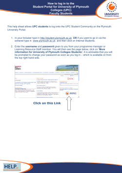
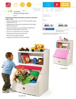


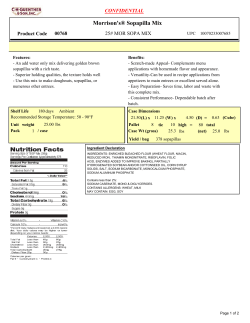
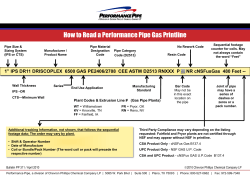


© Copyright 2026