
MINISTRY OF SCIENCE AND TECHNOLOGY DEPARTMENT OF TECHNICAL AND VOCATIONAL EDUCATION
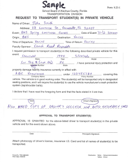
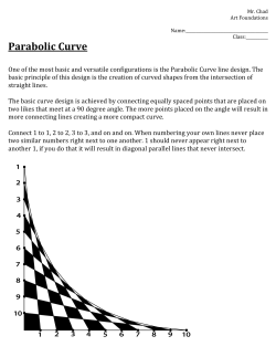
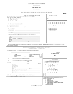
MINISTRY OF SCIENCE AND TECHNOLOGY DEPARTMENT OF TECHNICAL AND VOCATIONAL EDUCATION DEPARTMENT OF CIVIL ENGINEERING CE 3017-HIGHWAY AND TRAFFIC ENGINEERING (SAMPLE QUESTINS AND SOLUTIONS) SEMESTER I 1 SAMPLE QUESTIONS CHAPTER 2 HIGHWAY PLANING 1. (a)What is the object of highway planning? Write down the planning requirements. (b) Explain the items which would be included in the Road Inventory 2. Explain the methods of counting vehicle volume. 3. Explain the Origin and Destination Survey. CHAPTER 3 HIGHWAY LOCATION 4. Explain the highway plans and highway specifications. CHAPTER 4 DESIGN CONTROL AND CRITERIA FOR HIGHWAY DESIGN 5. Define the following terms: a) Flow or Capacity b) Concentration or Density c) Average Annual Daily Traffic (AADT) d) Average Daily Traffic e) Peak Hour Traffic f) 10th, 20th, 30th highest hourly volume 6. Write down the short notes on the following a) Traffic projection factor b) Design Volume c) Design Hourly volume 7. Write down the short notes on the following a) Theoretical or maximum Capacity b) Mean journey speed and mean running speed c) Spot speed d) Time mean speed and space mean speed 8.(a) An OD survey carried out to determine the current traffic on a section of a highway revealed an ADT of 5000 vehicles in the year 1960. It is proposed to improve the highway to cater for the needs of traffic in 1980. From a travel forecast of the area, the Normal traffic growth is found to be 52% of 1960 traffic. Generated traffic on the basis of pervious experience in the area estimated to be 22%. Information revealed that an increase of 2000 vehicles trips per day is expected by 1980 due to development traffic calculate the ADT in 1980 Local studies show that the ratio of DHV to ADT both two ways is 15% and are one way volume in the predominant direction is 60% of two way DHV. Calculate DHV in 1980. 2 (b) The OD survey curried out to determine current traffic on a section of four-lane twoway. Data obtained from OD survey are as follows: No. of days Volume/ 16 hours day in 1996 1 4180 2 4270 3 4300 4 4470 5 4870 6 5050 7 5240 It is proposed to improve the highway to cater for the nee of traffic in 2017. From travel forecast of the area, the NTG is 45% of 1995, the GTG is 25%. Information reveals that there is an increase of 2000 vehs trip/day due to the development traffic. Calculate the DHV for predominant direction in 2017. The thirtieth hour factor is 18% and volume in the predominant direction is 70% of two-way DHV. 9. (a) TRRL Method MON JAN 418 FEB 430 MAR 440 APR 456 MAY 471 JUNE 488 JULY 508 AUG 530 SEPT 508 OCT 468 NOV 446 DEC 454 AVG 468 TUE 421 442 447 464 487 505 524 531 513 479 459 464 478 WED 417 450 455 476 493 515 542 551 518 478 468 468 485 THU 429 450 457 489 506 520 545 547 527 491 472 473 492 FRI 439 465 478 501 527 530 587 572 552 509 490 488 515 SAT 392 416 443 467 492 521 582 558 546 470 434 436 470 SUN 394 391 424 452 506 486 562 521 539 428 402 462 456 AVG 409 434 449 472 497 509 550 544 529 474 453 463 On a rural road, traffic volume over 16 hours were recorded, Wednesday Thursday Friday 7th march, 8th march, 9th march, 1974 1974 1974 5850 vehs: 5700 vehs: 5950 vehs: What would be the predicted traffic on an average weekday in August 1990, assuming an annual growth rate of 5%. (b) Data for traffic spot speeds were detained by Enoscope over a base line of 200 feet. Stop- watch time t (sec) 2.6 2.8 3.0 3.4 3.6 Number of vehicles 11 27 62 52 34 Determine (a) Time mean speed (b) Space mean speed. 3 10. Spot speed data from collecting at a short distance of roadway are given below. Analyses are made by graphical method. Determent the design speed, maximum speed limit, minimum speed limit and then theoretical (or) maximum capacity of this roadway. No of Spot Speed (mph) vehicles 2 53 3 51.5 3 49 5 48 8 47.6 8 46.4 11 45.6 12 45 14 49.2 15 48 17 461 No of vehicles Spot Speed (mph) 19 20 22 21 20 18 16 9 8 5 2 45.2 43.0 40.1 35.5 34.3 32.7 30.0 26.2 23.1 20.9 18.2 CHAPTER 5 HIGHWAY GEOMETRIC DESIGN 11. (a) Write down the assumption for analyzing of Passing Sight Distance. (b) Drive the formula for determining passing sight distance for a two lane highway. 12. Define the Stopping Sight or Non-passing Sight Distance. How to calculate the stopping sight distance for a highway? 13. (a) What are the design controls for horizontal alignment design? (b) What are the design controls for vertical alignment design? 14. Derive the formula for calculating the rate of super elevation on the horizontal curve. 15. Explain the method of providing super-elevation by revolving the road surface about the crown-line of the road in second stage with neat sketches. 16. Explain the method of providing super-elevation by revolving the road surface about the inner edge of the road in second stage with neat sketches. 17. Explain the types of vertical curves with neat sketch. 18. Derive the formula for determination of highest point on summit curve. 19. Drive the formula for determination of lowest point on valley curve. 20. (a) Calculate the stopping sight distance for a road for which the design speed is 30 mph. The coefficient of fiction between the road surface and tires may be taken as 0.4 and the reaction time of the driver may be assumed as 3 seconds. The road way is level. (b) Calculate the passing sight distance for a road for which the design speed is 30 mph. The rate of acceleration of the first moving vehicle may be taken as 2.5 mph/sec and the different in speeds between the overtaking and the overtaken vehicles as 10 mph. 21. (a) Calculate the stopping sight distance for a road for which the design speed is 30 mph. the coefficient of friction between the road surface and tires may be taken as 0.4 and the reaction time of the driver may be assumed as 3 seconds. The road way is level and the brake efficiency is 40%. 4 V2 30 f where, d = breaking distance in feet v = speed of vehicle in m.p.h. f = coefficient of friction (b) Calculate the non-passing sight distance required on a highway with a design speed of 60 mph, assume f = 0.42. Also assume reasonable values for other items involve in calculation. Given the Braking dis tan ce as d 22. (a) Determine the minimum non-passing sight distance that should be provided for a vehicle coming down a 6% gradient. Give the following data. Design speed V = 35 mph 140 Re action time of driver sec s 35 V Coefficient of friction between type road surface = 0.5 (b) Cuts of a two lane highway have a back slope of 1:2 (1 horizontal: 2 vertical) and the grade line is level. Calculate the distance required between the centre of the road and the toe of the cut slope to satisfy the horizontal sight distance on a circular curve of radius of 1910 feet. The eye is assumed to be 4.5 ft above the road surface and the object is also 4.5 ft high. Assume Design speed of the road = 40 mph Reaction time of driver = 2 seconds. The coefficient of friction of the road = 0.6 with the safety factor of 2.0 Horizontal and curve length are the same. 23. (a) A jeep catching up a slow moving truck a two lane highway on which the design speed is 40 mph. the jeep is traveling at the design speed and the distance between the jeep and truck is 120 feet. The driver of the jeep saw the slow moving truck suddenly brakes to a stop. Jeep driver is so alert that his reaction time is 2.5 sec. is the braking distance of the truck is 120 feet. Will the jeep be able to stop in time without colliding the truck? Use coefficient of friction of 0.6. Assume the road is level. (b) A deer is running across the level road and a driver did his best to avoid hitting this deer by attempting to stop his car. However, during the braking, his car slided from the concrete pavement to the gravel shoulder but finally came to a halt safely. If the traveling speed of this car is 100 kph and coefficient of friction on the concrete pavement is 0.252, then what should be the coefficient of friction on the gravel shoulder? Assuming that the lengths of skid marks on concrete pavement and gravel shoulder are 100m. and 50m., respectively. Reaction time is 0.5 sec. 24. Sketch the longitudinal profile and show the stationing of key points along the roadway. Assume that the side friction is neglected and the super elevation is obtained by revolving the road surface about the center line or crown. The following data are given: Design speed V = 40 mph Degree of Curve D = 8º Width of the pavement =b = 24’ Amount of normal crown = c = 3” The road is passes through the open flat country, maximum super-elevation runoff is 1:150 5 Normal crown ends at station 20+00 25. Degree of curve = 8º Design speed V = 40 mph Width of the pavement b = 24’ Amount of normal crown c = 3” 1 15 Allowable maximum super- elevation runoff 1: x = 1:200 Normal crown ends at sta: 20+00. Sketch the longitudinal profile. Assume ‘f’ is neglected and full super elevation is obtained by revolving about the centre line or crown. Allowable max imum rate of sup er elevation, emax CHAPTER 2 (from semester II) DRAINAGE AND EROSION CONTROL DRAINAGE AND DRAINAGE STRUCTURES 26. (a) Describe the requirements of the good road drainages system. (b) Describe the causes of change in moisture content. 27. Describe the major causes of erosion and controlling method for a highway engineer. 28. Describe the side ditches, curbs and gutters for surface drainage. 29. Describe the intercepting drains, pipe drains, inlets, catch basins and manholes for surface drainage. CHAPTER 8 (from semester II) ROADSIDE DESIGN 30. Draw the guardrails and median barriers for roadside design. 6 SOLUTIONS 1. (a)What is the object of highway planning? Write down the planning requirements. (b) Explain the items which would be included in the Road Inventory Solution: (a ) Object of Highway Planning The object of highway planning is to provide a highway system which would give maximum transportation facilities a minimum cost. For this purpose, a well defined programme to collect data and analyze the existing conditions is most essential Planning Requirements Highway planning would include. (1) Collection and tabulation of the formation about the existing transportation facilities in the area. (2) Determination of the general inter-relation of all branches of the transportation system and their effect on each other. (3) Determination of the adequacy or otherwise of the existing facilities as per present needs and the improvements and extension of these facilities for anticipated future needs for a certain period. (4) Finding out the methods for financing these projects and the periods over which the construction can be spread. (5) Estimating of the cost of construction and maintenance. (b) Items which would be included in the Road Inventory are: (1) Clear demarcation of different states in the country from roadway point of view. (2) Man-made and natural features adjacent to the road. e.g. buildings, landlines, fence-lines, monuments, bench marks, water courses etc. (3) Description of the geometrics of highway such as roadway width, right of way width, sight distance, curve dial, gradients and road camber etc. (4) Information about the structural components of the pavement, surface type and the pavement design, its cross section and soil characteristics. (5) Roadway condition, i.e. conditions of surfaces, drainage and riding qualities etc. (6) Detail information about the type of drainage, structures, their location, number of spans, lateral clearance, distance between roadway surface and stream bed, width of the structures, vertical clearance, load-capacity, condition of structures, adequacy of waterway and the approach alignment. (7) Railroad crossings, their names, number of rail tracks, gradients of the highway at approaches, angle of crossings, property of sight distance, curvature if any, near it. (8) Land-use, agricultural and other potential periodicity. (9) Classification of the highway and its service to community. (10) Traffic volume, speeds and accident experience on the road. (11) Maintenance cost of the highway etc. 2. Explain the methods of counting vehicle volume. Volume of traffic using a section of road can be measured by counting vehicles passing a fixed point in both directions. 7 Manual methods In this method, the passing of a vehicle is recorded by an enumerator a specially prepared form or on a series of hand tallies, the vehicles being simultaneously classified into a number of predetermined groups. For many purposes, it is usual to convert the actual numbers of vehicles into equivalent passenger car unit (p. c. u); these values being determined by the relative effects of different types of vehicles on traffic flow. Since the effect of a bus or heavy commercial vehicle in a traffic stream varies according to the precise road and traffic conditions, it is not possible to give general value to suit all purposes. On account of the labor involved in the conducting of a manual count, the period of counting has generally to be limited to a few days. Observations are usually made over the 16 hr-period from can 6am to 10pm and should preferably continue over several consecutive days. Since traffic flow varies from month to month throughout the year, the volume count should be taken at the busiest time of the year. Automatic Methods The passing of vehicle can be recorded automatically by special equipment used in conjunction with some form of vehicle detector. The type most commonly used is a pneumatic detector, which consists of a length of thick walled rubber tubing about ¼ in internal diameter fastened down to the surface of the road perpendicular to the direction of the traffic. The passage of a vehicle axle over the tube transmits a pressure pulse through the tube which operates an electrical contact on a diaphragm switch, so actuating a counter which is arranged to register every other pulse in order to correspond to one count per vehicle. Automatic methods of counting have the advantage that little attendant labor is required, particularly with the more elaborate type of counters, and therefore measurements can be made for long periods. Such counters are thus ideally suited for the continuous measurement of seasonal and annual trends at the selected sites. The chief advantage is that these counters are not able to give a classification break down and therefore the results must generally be supplemented by a sample manual count. Other disadvantages are that errors can be incurred with multi-axle vehicles and also with light vehicles such as pedal cycles which may fail to register when using pneumatic detector tubes. 3. Explain the Origin and Destination survey. Solution Origin and Destination Survey An O.D Survey is necessary where it is anticipated that traffic will be drawn from a number of existing routes onto a new or improved road. By means of this type of survey it is possible to estimate the number of drivers traveling on each of the existing routes who will choose to use the new road in future. The O.D survey obtains, in addition to straight forward count of vehicles on each road, further information concerning the place of origin and destination of each journey and the location of any intended intermediate stops within the survey area. 8 Survey Stations must be established on all the main roads entering and leaving the area concerned, so forming a cordon or screen line. Sites for these stations should be on straight, level sections of road with good visibility. There are a number of basic method by which the required information may be obtained, namely (1) By roadside interview. (2) By the use of prepaid postcards (3) By attaching colored tags or stickers to vehicles (4) By observing vehicle registration numbers (5) By selective interview at home or at the place of employment 1) By roadside interview In this method vehicles are stopped and the drivers are questioned as to the origin destination of the journey and the location of proposed intermediate stops. The sampling technique may be carried out on either a numeral or a time basis, but in all cases the system should be prearranged and used consistently. One method is to stop every nth vehicle, whilst another is to stop all vehicles arriving within certain fixed time limits. Both methods have the disadvantage that queues may form during times of heavy flows and a third method which involves stopping the next vehicle arriving after the completion of successive interview may be preferred. In all cases, at least two people are required, one to carry out the interviews and one to count and direct traffic, and after it may prove advisable to use more than one interviewer. (2) By the use of Prepaid Postcards This system is to hand each driver a business reply-type prepaid postcard. Questions asked by the interviewer are tabulated and the driver is requested to answer these and also supply the additional information concerning the type of vehicle and number of passengers before returning the card by post to the survey headquarters (3) By attaching colored tags or stickers to vehicles At the incoming survey station, a tag of distinctive color is stuck on the wide screen of each vehicle entering the survey area, a different color and shape being used at each point. Observers at the outgoing survey stations note the color designation for each vehicle leaving the survey area, and, if desired, other observers at selected points within the area may be used to help trace the routes followed by the vehicles. (4) By observation vehicle registration number The methods mentioned above all suffer from the disadvantage that vehicles have to be stopped to some extent. An alternative method in which the registration numbers of vehicle passing the survey station are noted avoids these disadvantages. To work effectively in heavy flows, two observers are required; one reading the registration numbers of passing vehicles and the other nothing them down. Alternatively a single observer can record the information into a portable type recorder. (5) By selective interview at home or at the place of employment In this method, a random sample of population is interviewed either at home or at the place of employment to obtain information concerning details of all journeys made by the person of family concerned on a particular day or days. 4. Explain the highway plans and highway specifications. Solution Highway plans In general, the plans contain the engineering drawings of the project whereas the specifications present the written instructions. 9 After the final location for a given project has been completed, including the field soils investigation the data are forwarded to the design office. There a complete scheme for the road is worked out by the specialist in the fields of geometric design, drainage, structures, soils and pavements. All the dimensional features and many other details of each final design are recorded on a series of drawings commonly refers to as plans. Figure shows one sheet of plans for a typical two lane rural highway. Other sheets of plans show roadway cross-sections fitting every situation in the entire project. Figure is typical. Also included will be sheets of drawings for all structures and roadway appurtenance. A partial list of subjects covered by the standard would include pipe culverts, concrete box culverts, guard rails and parapets, curbs and gutters and curb returns, sidewalks, drainage inlet and outlet structures of numerous types, manholes, riprap and other devices used for bank protection, fences, and right of way and other permanent survey markers. Highway specifications Specifications can result in the use of improper materials and poor workmanship. On the other hand, specifications are too exacting results in higher cost. Specifications contain the written instructions highway projects and outline carefully and detail the procedures and the methods to be followed for each operation. Often they are divided into two parts: standard specifications and special provisions. The standard specifications apply to every project constructed by the agency and treat subjects that occur repeatedly in the agency’s work. The special provisions cover subjects peculiar to the projects and in question and include additions or modifications to the standard specifications. The special provisions issued by some highway agencies include copies of all the documents required for securing competitive bids and for the contract. This is helpful to both contractor and construction engineer. 5. Define the following terms: a) Flow or Capacity b) Concentration or Density c) Average Annual Daily Traffic (AADT) d) Average Daily Traffic e) Peak Hour Traffic f) 10th, 20th, 30th highest hourly volume Solution a) Flow or Capacity The number of vehicles passing a point in a unit time. b) Concentration or Density The number of vehicle traveling over a unit length of highway at a specified instant in time. c) AADT. (Average Annual Daily Traffic) The total yearly volume divided by the number of days in the year. d) ADT (Average Daily Traffic) The total volume during a given period divided by the number of days in that period. No. of days Traffic Volume Day 1 x1 10 Day 2 Day n AADT = x x2 xn n n n =365-366 xn ADT = n n= 7, 14 e) Peak Hour Traffic The highest number of vehicles found to be passing over a section of a lane or a roadway during 60 minutes. f) Tenth, Twentieth, Thirtieth etc. Highest Annual hourly Volume The hourly volume on a given roadway that is exceeded by 9, 19, 29 etc, respectively hourly volume during a designated year. 6. Write down the short notes on the following a) Traffic projection factor b) Design Volume c) Design Hourly volume d) Theoretical or maximum Capacity Solution a) Traffic projection factor The future needs of traffic over a period of 20-25 years, which is taken as the normal life of a highway, it is essential to know the development of traffic and its ultimate value at the end of the design period. The design period is usually taken as 20 years. It is not possible to project traffic to some future year exactly but a reason ably accurate value can be arrived at by considering the following elements Current traffic, made up of (i) Existing traffic: and (ii) Diverted traffic. Increase in traffic due to (iii) Normal Traffic growth: (iv) Generated Traffic growth. (v) Development traffic growth Traffic Projection Factor 1 sum of the % of NTG , GTG and DTG with respect to current traffic 100 NTG % GTG % DTG (%) TPF 1 1.0 100 b) Design Volume Traffic studies on highway both in rural and urban areas have shown that the traffic volume varies considerably in volume throughout the day and even a greater fluctuation in hourly volumes is indicated during a year. So it is essential to determine which of the hourly volumes should be used for design since such a situation arises, 11 only once a year and the rest of the period during the year, such a situation does not arise. At the same time the hourly volume used for design should not be exceeded very often during the year. It has been established that where only motor traffic is involved, the design should be based upon the 30th Highest Hourly Volume (30 HV) so that this volume of traffic is exceeded only 29 hourly volumes in a year. c) Design Hourly volume,DHV Design hourly volume to be taken for highway catering for motor traffic only should be the 30th highest hourly volume. The DHV may be repressed as a percentage of ADT (or) 30th Hour factor (k) both taken two ways. DHV for future needs can be estimated by Traffic projection factor method and (a) Transport and Road research lab method (b) d) Theoretical or maximum Capacity The maximum number of vehicles which has passing over a given section of a lane or roadway in one direction (or) in both direction for two lane or three-lane during a given time period. The theoretical (or) Maximum Capacity (Qmax) can be expressed by headwayspeed relationship. 5280V Qmax 20 1.04V 0.053V 2 where Qmax = Maximum Capacity in veh/hr V = speed in mph 7. Write down the short notes on the following a) Mean journey speed and mean running speed b) Spot speed c) Time mean speed and space mean speed Solution a) Mean journey speed and mean running speed Mean journey speed It is derived from measurement of journey time between two points a known distance apart, delays arising from traffic control measures and congestion being included in the journey time. Mean running speed It is reduced by a moving observer in the same manner as the mean journey speed, except that all the periods of time when the vehicle is actually stationary are deducted from the total journey time. Delays caused by congestion and other factors which the slow down the vehicle without actually stopping it will still be included.] b) Spot speed It refers to the speed of vehicle at one particular instant of time at a specified location. Spot speed has a variety of uses. They can be used as evidence regarding the effect of particular traffic flow construction such as intersection and bridges. They can be used for geometric design purpose or improved or new facilities. Spot speeds are also used in determining enforceable speed limits. Spot speed measurement should be conducted so as to reduce a minimum influence of the observer and his equipment upon the values obtained. Hence the observer and equipment should be located as in conspicuous as possible. It can be measured directly by various methods and is not possible to measure all vehicles. Vehicles should be selected at random from the traffic stream. 12 c) Time mean speeds and space mean speed Time Mean Speed It is an arithmetic mean of speed of vehicles passing a point during a given interval of time. Space Mean Speed It is the arithmetic mean of speed of vehicles on a given length of road at an instant in time. The difference between the two can be illustrated by considering a set of vehicles spaced a uniformed distance apart along an infinite length of road and all moving at the same speed V1 together with a second set of vehicles superimposed in the first and also speed uniformly, but moving at a constant speed V2 in speed measurements are made on all vehicles within the fixed length L of road at a particular instant of time, then the averages speed or space mean speed Vs is given by: mV1 V2 .... Vs m n .... where, there are m vehicles moving at speed V1 and n vehicles at speed V2 within this length at any given time. Suppose that instead of measuring the speed of all vehicles within the fixed length L, measurements are made on all vehicles passing a fixed point during a time interval t. There will be mt V1/L vehicles in this time moving at speed V1 and nt V2/ L vehicles in this time moving at speed V2. Therefore, the average speed or time mean speed VT is given by: mtV1 ntV2 V1 2 2 L L mV1 nV2 ... VT mtV1 ntV2 mV1 nV2 ... L L 8. (a) An OD survey carried out to determine the current traffic on a section of a highway revealed an ADT of 5000 vehicles in the year 1960. It is proposed to improve the highway to cater for the needs of traffic in 1980. From a travel forecast of the area, the Normal traffic growth is found to be 52% of 1960 traffic. Generated traffic on the basis of pervious experience in the area estimated to be 22%. Information revealed that an increase of 2000 vehicles trips per day is expected by 1980 due to development traffic calculate the ADT in 1980 Local studies show that the ratio of DHV to ADT both two ways is 15% and are one way volume in the predominant direction is 60% of two way DHV. Calculate DHV in 1980. (b) The OD survey curried out to determine current traffic on a section of four-lane two-way. Data obtained from OD survey are as follows: No. of days Volume/ 16 hours day in 1996 1 4180 2 4270 3 4300 4 4470 5 4870 6 5050 13 7 5240 It is proposed to improve the highway to cater for the nee of traffic in 2017. From travel forecast of the area, the NTG is 45% of 1995, the GTG is 25%. Information reveals that there is an increase of 2000 vehs trip/day due to the development traffic. Calculate the DHV for predominant direction in 2017. The thirtieth hour factor is 18% and volume in the predominant direction is 70% of twoway DHV. Solution (a) Normal traffic growth = 52% Generated traffic growth = 22% 2000 Development traffic x100 40% 5000 Sum of the traffic growth = 52+22+40 =114 NTG % GTG % DTG % Traffic projecton factor (TPF ) 1 100 114 1 2.14 100 Hence future ADT (1980) = TFP x ADT (1960) = 2.14 x 5000 = 10700 vehicles Two-way DHV in 1980 provided the traffic is equal in both directions = ADT (1980) x 30th hour factor (k) 15 10700 x 1605 vehilces per hour 100 DHV in 1980 in the predominant direction 60 1605 x 963 vehs : / hr 100 or say the design may be carried out for 1000 vehicles per hour Xn n 418 4270 4300 4470 4870 5050 5240 7 ADTcurrent ADT1995 (b) = 4626 vehs/16 hrs NTG = 45%, GTG = 25% DTG = 2000veh trip/day 2000 x100 4626 = 43.23% k = 18% % in predominant dir. = % DHV2017 in the predominant direction = ? X 2017 in the predominant direction = 0. 7 x DHV2017 in both direction 14 NTG % GTG % DTG % 100 45 25 43.23 1 2.1323 100 Traffic projecton factor (TPF ) 1 ADTfuture = TPF x ADTcurrent = 2.1323 x4626veh/16hr day DHV2017 in both direction = kxADT2017 =0.8x9864= 1776= 1224veh/hr 9. (a) TRRL Method MON JAN 418 FEB 430 MAR 440 APR 456 MAY 471 JUNE 488 JULY 508 AUG 530 SEPT 508 OCT 468 NOV 446 DEC 454 AVG 468 TUE 421 442 447 464 487 505 524 531 513 479 459 464 478 WED 417 450 455 476 493 515 542 551 518 478 468 468 485 THU 429 450 457 489 506 520 545 547 527 491 472 473 492 FRI 439 465 478 501 527 530 587 572 552 509 490 488 515 SAT 392 416 443 467 492 521 582 558 546 470 434 436 470 SUN 394 391 424 452 506 486 562 521 539 428 402 462 456 AVG 409 434 449 472 497 509 550 544 529 474 453 463 On a rural road, traffic volume over 16 hours were recorded, Wednesday Thursday Friday 7th march, 8th march, 9th march, 1974 1974 1974 5850 vehs: 5700 vehs: 5950 vehs: What would be the predicted traffic on an average weekday in August 1990, assuming an annual growth rate of 5%. (b) Data for traffic spot speeds were detained by Enoscope over a base line of 200 feet. Stop- watch time t (sec) 2.6 2.8 3.0 3.4 3.6 Number of vehicles 11 27 62 52 34 Determine (a) Time mean speed (b) Space mean speed. (a) Solution 1974 March Available) 1974 August 1990 August (Required) Best estimation of average weekday’s traffic in March 1947 is 15 1 3 449 449 449 5850 x 455 5700 x 457 x 5950 x 478 5654 vehicles / 16 hr day Best estimation ofaverage weekday traffic in August 1974 is 544 5654 x 6850 vehicle / 16 hr day 449 n ADT 1990 1 y ADT 1974 16 5 1 x 6850 14 ,953 vehicles / 16 hr day 10 (b) Solution Time t (sec) no. of veh. 2.6 11 2.8 27 3.0 62 3.4 52 3.6 34 Total 186 (a) Time mean speed, VT V (ft/sec) 76.92 1.42 66.67 58.82 55.55 mV12 65083.55 137722.04 275583.11 179909.20 104917.28 763215.18 mV1 846.12 1928.34 4133.54 3058.64 1888.7 11855.34 mtV1 ntV2 V1 2 2 L L mV1 nV2 ... VT mtV1 ntV2 mV1 nV2 ... L L 763215.18 64.38 ft / sec 43.79mph 11855.34 (b) Space mean speed, Vs mV1 V2 .... 11855.34 Vs 63.74 ft / sec 43.36mph m n .... 186 16 10. Spot speed data from collecting at a short distance of roadway are given below. Analyses are made by graphical method. Determent the design speed, maximum speed limit, minimum speed limit and then theoretical (or) maximum capacity of this roadway. No of Spot Speed (mph) vehicles 2 53 3 51.5 3 49 5 48 8 47.6 8 46.4 11 45.6 12 45 14 49.2 15 48 17 461 No of vehicles Spot Speed (mph) 19 20 22 21 20 18 16 9 8 5 2 45.2 43.0 40.1 35.5 34.3 32.7 30.0 26.2 23.1 20.9 18.2 Solution Speed Class Interval CI R 53 18.2 3.9 4 vehilces per hour 1 3.322 log n 1 3.322 log 258 Speed class Avg: (mph) speed (mph) 15-18.9 17 19-22.9 21 23-26.9 25 27-30.9 29 31-34.9 33 35-38.9 37 39-42.9 41 43-46.9 45 47-50.9 49 51-54.9 53 total No of vehs: frequency Commutative frequency 2 5 17 16 38 21 22 87 45 5 258 0.78 1.94 6.59 6.20 14.73 8.14 8.53 33.72 17.44 1.94 0.78 2.75 9.31 15.51 30.24 38.38 46.91 80.63 98.07 100.0 17 Minimum speed limit = 15 percentile speed = 30.5 mph Medium speed limit = 50 percentile speed = 44 mph - to determine the maximum capacity 5280V 5280 x 47.8 2 20 1.04V 0.053x V 20 1.04 x 47.8 0.053 x 47.8 2 1323 veh / hr Qmax 11. (a) Write down the assumption for analyzing of Passing Sight Distance. (b) Drive the formula for determining passing sight distance for a two lane highway. Solution (a) Assumptions; (1) Speed of overtaken vehicles is considered as uniform along the road and equal to (Vm) mph. (2) Passing is accomplished by accelerating during the entire period. (3) A passing (overtaking) vehicle is forced to travel at the same speed as the overtaken vehicle before overtaking. (4) The opposite vehicle appears at the instant where the overtaking maneuver begins and it travels at the design speed V mph. (5) The driver of the passing vehicle requires a short period of perception time to take over the situation. 18 For two lane highways, passing sight distance represents the sum of these distances. Passing right distance D = d1 + d2 + d3 Where d1 = Distance traveled by the vehicle ‘A’ from its position A1 during the perception time “to” taken by the driver of ‘A’ to decide whether or not he should be taken over the slow moving vehicle B. d2 = Distance traveled by the vehicle ‘A’ from its position ‘A1’ to its position at ‘A2’ during the actual overtaking time ‘t’ d3 = Distance traveled by the vehicle ‘C’ from its position ‘C1’ to its position at ‘C2’ during the time in which the overtaking operation is completed (i.e. overtaking time t) Let, V = design speed for the road in mph. M = difference in speeds of the fast moving vehicle ‘A’ and the slow moving vehicle ‘B’ in mph. v, m’ = the corresponding values of V and m respectively in ft/sec. a = Rate of acceleration during the overtaking maneuver in mph/sec, during the time interval of t seconds. a” = the corresponding rate of acceleration, in ft/sec2 t = time interval in seconds to complete the actual overtaking operation. S = Average speed of vehicles in the positions when they are closet just before and just after the overtaking operation; and is usually called the headway to = the perception time during which the driver of vehicle ‘A’ gauges the situation, watches the opposing traffic, gets the signal from the vehicle moving ahead and decides to overtake. It has been observed that the value of “S” so calculated is in excess of the actual spacing between vehicles in such a case. In general, - S in ft = Speed of vehicle B in mph + length of the vehicle in ft S = (V-m) + 20 feet - The perception time t0 is assumed as 2 seconds since most of the drivers can visualize the whole situation within this period. The distance d1, d2, d3 may then be calculated as under. Distance d1: Distance d1 = 1.47 x (V –m)x t0 in feet = 1.47 (V-m) x 2 in feet OR d1 = 2.94 (V-m) feet d2 = 2s + the distance covered by the slow moving vehicle in time t OR d2 = 2s + 1.47 (V-m) x t in feet The distance d2 can also be calculated by another method, is by considering the distance traveled by vehicle A with an initial speed of (V – m) and an acceleration ‘a’ in time ‘t’ all taken in the same system of units. Assuming, for the time being, the speed in feet/sec distance in feet and time in seconds, This distance covered by the vehicle A is given by 19 1 at 2 2 d 2 v m x t 2 s from equaiton : (9 ) d 2 v m x t also ( v m ) t 1 a t 2 ( v m ) t 2 s 2 1 a t 2 2 s 2 4S t a' Now .if accelerati on rate is taken in mph / sec or 2 .73 S , where , ' t ' in sec ond and ' a ' in mph / sec a Dis tan ce d 3 ; d 3 1 .47V x t in feet t The passing sight distance D = d1 + d2+ d3 for two lane highways. 12. Define the Stopping Sight or Non-passing Sight Distance. How to calculate the stopping sight distance for a highway? Solution Analysis of stopping sight distance Reaction time and Breaking time. (a) Reaction time The time elapsed between the instant when the danger was first realized up to the instant just before starting applying the brakes. The reaction time depends upon the physical and mental ability and alertness of the driver. If can be divided into two parts. (1) Perception time and (2) Foot reaction time (1) Perception time The time that further elapses between the moment that the danger was first realized and the moment the message is conveyed to the foot of the driver to take action. (2) Foot reaction time The time that further elapses between the moments that the foot is removed from the accelerator and place on the brake paddle is known as foot reaction time. Then, Reaction time = Perception time + Foot Reaction time (b) Reaction Distance The distance traveled by the vehicle during the reaction time is called the Reaction Distance. If V is the speed in mph and t, the reaction time in seconds, then the distance covered during. The reaction time called the Reaction distance is given by 88 x V x t 1.47 V x t feet 60 Braking Distance 20 The distance which the vehicle covers from the time of application of brake while moving of the design speed to the time when it comes to a stop is called the Braking Distance. It can be determined by two methods. - From considerations of the coefficient of friction of the vehicles tires against 1st method the road surface. - From considerations of the efficiency of the vehicle. 2nd method - The Breaking distance may be calculated as under. 1st method Let D = Breaking distance in feet after application of brakes f = Coefficient of friction between the tires and the road surface v = Speed of the vehicle at the time the brakes are applied (in ft/sec) W = Weight of the vehicle in lbs. g = Acceleration due to gravity (32.2 ft/sec2) Then, on a level surface, the force along the surface = W x f Work done by the vehicle in the distance D before stopping under this force = W x f x D Work done = the difference in the kinetic energy W v2 g 2 Equation (1) and (2) W v2 W f D g 2 v2 D in fps system 2g f If the speed of the vehicle has to be taken in m.p.h i.e. V = mph, then the formula (3) becomes 2 1.47V D 2gf D V2 on level road 30 f D V on grade 30 ( f G ) Take + ve sign for uphill - ve sign for do until Where D is in feet and V in m.p.h 2nd Method Let D = Braking distance in feet = Efficiency of vehicle brakes in percent v = Speed of the vehicle at the time the brakes are applied (in ft/sec2) -g = Deceleration rate due to gravity (32.2 ft/sec2) Assumed with 100% efficient brakes The vehicle moves from a speed of v ft/ sec to a stop in distance D feet. 21 g Also deceleration produced by brakes with an efficiency of ft sec 2 100 Then the bodies in motion V2 – U2 = 2as Where, V = final speed a = rate of acceleration s = distance covered 02 V 2 2 D v gn x D 100 2 2 g / 100 if V m. p.h; equ n: (5) becomes 2 1.47V D 2 g / 100 V2 30 / 100 Where D is in feet and V is in m.p.h. or D 13. (a) What are the design controls for horizontal alignment design? (b) What are the design controls for vertical alignment design? Solution Design Controls for Horizontal Alignment (1) Alignment should be as directional as possible. (2) Use of maximum radii of curvatures should be made for the prescribed design speed since that leads to uniform speeds and greater safety. (3) Surprise elements e.g. sharp curvature after easy alignment, should not be introduced and consistency of design maintained as far as possible. (4) On high and long embankments, only that curves should be used and to safeguard against any emergency, properly designed guard-rails should be provided. (5) Reverse curves which introduce abrupt reversal in the direction of motion of the vehicle should be avoided. (6) Horizontal and vertical alignment should be properly coordinated in order to give a uniformly of design for safe operation. (7) Curve approaches to the bridges should be avoided. (8) Sites for rail-road crossings must be carefully selected and curved approaches to such crossings avoided. Design control for the vertical alignment design g) Short lengths of steep grades and numerous breaks should be avoided. Instead, it is perfectible to have a grade line with gradual changes consistent with the topographic features of the area by making use of standards laid down for gradients in a manner that gives the feeling of a continuous line h) Sudden, hidden and unexpected dips are undesirable since they present hazardous situations. 22 i) Two vertical curves in the same direction separated by a short section of a tangent grade should be generally avoided. j) Where the length of a grade line is sufficiently great, it is preferable to provide steeper grades of the bottom of an up grade and go on making it milder till the top is reached, instead of making it a uniform sustained grade k) Separate lanes should be provided for slow moving traffic when the length of the road along any particular grade exceeds the initial length conveniently negotiable by slow traffic l) Where the highways meet at grade and they run at steep to moderate gradients, it is better to reduce the gradient near and at the crossing to decrease the chances of accidents. 14. Derive the formula for calculating the rate of super elevation on the horizontal curve. Solution Maximum allowable rate of super elevation Super elevation may be defined as the raising of the outer edge of the road along a curve in order to counteract the effect of centrifugal force, in combination with the friction between the road surface and tires developed in the lateral direction. Let the road curve be super elevated at the rate of one in ‘e’ and let the inclination of the plane of the surface to the horizontal be ‘ө’. Then, tan ө = e. let W = Weight of the vehicle in lbs acting vertically downwards. v = Speed of the vehicle in feet/sec at the curve. R = Radius of curvature in feet. f = Lateral coefficient of friction between the road surface and tires. R’ = normal reaction of the road on the road surface 23 Wv 2 , The centrifugal force (C.E) acting in the outward direction gR where g is the acceleration due to gravity in ft/ sec2 Wv 2 sin W cos gR Force of friction along the surface of the road acting down incline tending to partially the effect of the C.F shall be equal to f R’ The Raction R N L N R Wv 2 cos gR Substituting the value of R’ from equation (11) in equation (12) we have, f R W sin Wv 2 Wv 2 sin W cos cos W sin gR gR v2 fv 2 sin f cos cos sin gR gR v2 fv 2 1 sin f cos gR gR 2 v f sin gR tan 2 cos 1 fv gR v2 f gR e 1 fv 2 gR Since, the value of f is very low, the factor fv2/gR in the denominator may be ignored for all practical purposes 24 e v2 f gR v2 gR This is the relation between the rate of super elevation, the coefficient of friction, the design speed and the radius of the curve. V in equation (13) is called Centrifugal ratio. The exp ension gR OR 1.47 V 2 e f gR e f 1.47V 2 32.2 R V2 V2 OR R 15 R 15e f Where V = design speed in mph If ‘f’ is neglected and V is taken as 0.75 of the design speed, we have e f Super elevation e 0.75V 2 15R 15. Explain the method of providing super-elevation by revolving the road surface about the crown-line of the road in second stage with neat sketches. Solution Method of Providing Super-elevation The super elevation at the curves is provided in two stages: 1st stage: Neutralizing the camber of the road gradually and bringing it to straight line slope. 2nd stage: Increasing the slope of this line gradually till design super elevation is attained The 1st stage involves the rotation of the outer slope of camber about a pivot point, the level of which is kept constant throughout the length till the camber is neutralized. After the surface becomes a straight fall, full super elevation is gradually achieved by any of the following two methods: 1st method- In the1st method, the surface of the road is rotated about the crown (pivot point) 2nd method- In the second method, surface of the road is rotated about the inner edge of the road. 25 26 27 16. Explain the method of providing super-elevation by revolving the road surface about the inner edge of the road in second stage with neat sketches. Solution Method of Providing Super-elevation The super elevation at the curves is provided in two stages: 1st stage: Neutralizing the camber of the road gradually and bringing it to straight line slope. 2nd stage: Increasing the slope of this line gradually till design super elevation is attained The 1st stage involves the rotation of the outer slope of camber about a pivot point, the level of which is kept constant throughout the length till the camber is neutralized. After the surface becomes a straight fall, full super elevation is gradually achieved by any of the following two methods: 1st method- In the1st method, the surface of the road is rotated about the crown (pivot point) 2nd method- In the second method, surface of the road is rotated about the inner edge of the road. 28 29 17. Explain the types of vertical curves with neat sketch. Solution Types of vertical curve Summit curves and Valley curves 30 Summit curves The major factor affecting the design of summit curves is the sight distance across the summit since it is essential that an obstruction on the other side of the summit whether stationery or in motion must be visible to the driver on this side of summit and vice versa. Summit curves are required to be introduced at the situations where, (1) A positive grade meets a negative grade (2) A positive grade meets another milder positive grade (3) A positive grade meets a level stretch (4) A negative grade meets a steeper negative grade Valley curves The problems of seeing across the road on both sides do not exist. Valley curves are required to be introduced at the situation where (1) A negative grade meets a positive grade (2) A negative grade meets a milder negative grade (3) A negative grade meets a level stretch (4) A positive grade meets a steeper positive grade 31 18. Derive the formula for determination of highest point on summit curve. Solution Highest Point or the Summit Point on the curve Sometimes the highest point on the curve is required to be located a. If the gradients on either side of the point of intersection are equal, the highest point lies on the bisector of the angle between the two grades. b. If the gradients on either sides of the point of intersection are unequal the highest point lies on the side of the flatter grade. The calculations for location can be made as under. Let Xh be the distance AD of the highest point C on the curve measure d along the x axis from the start of the curve on the steeper grade and yh be its ordinate from the first grade line and equal to QC. 32 Let the distance CD is denoted by :z Then Also x QC y h h a QD g1 x h 2 From the above two equations 2 x CD Z QD QC g1 x h h a 2 x Z g1 x h h a dz Now, if c is the highest on the curve then should be zero dx h i.e. g1 2 xh 0 a 2L G , then, g1 x h 0 G L g x h 1 .L G g1 OR xh g1 g 2 .L The distance xh is measured from the start of the curve on the side of the steeper grade and the highest point lies on the side of flatter grade. Put a 33 19. Drive the formula for determination of lowest point on valley curve. Solution Lowest point on the curve Sometimes the lowest point on the curve is required to be located. It is essential in the valley curves, since if any gutter-gratings are fixed at any other point, the water may collect on the curve during the rainy season and damage the road. Its position may be located as under. (a). If gradients on either side of the points of intersection are equal, then the lowest point lies on the bisector of the angle between two grades. (b). If the gradients on either side of the point of intersection are unequal, then the lowest point lies on the side of the flatter grade. The calculations can be made as Fig. 5.19 Determination of lowest point on valley curve Let xL be the distance AD of the lowest point C on the curve measured along the x-axis from the start of the curve on the steeper grade and yL be its ordinate from the 1st grade line equal t QC in Figure, Let the distance CD be denoted by z. 2 x1 Then QC y1 b Also QD g1 x L From the above two equations, 3 x CD QD QC g1 x L L b 3 xL Z g1 x L b If C is the lowest point on the valley curve, then dz/x should be zero 34 3 3x g1 L 0 b 3 L Put b . 2 G 2G 2 Then, g1 2 x L 0 L g1 L2 2 xL 2G g1 L xL G 2 g1 g1 g 2 The distance xL is measured from the start of the curve on the side of the steeper grade and the lowest point lies on the side of the flatter grade. or xL 20. a) Calculate the stopping sight distance for a road for which the design speed is 30 mph. The coefficient of fiction between the road surface and tires may be taken as 0.4 and the reaction time of the driver may be assumed as 3 seconds. The road way is level. (b) Calculate the passing sight distance for a road for which the design speed is 30 mph. The rate of acceleration of the first moving vehicle may be taken as 2.5 mph/sec and the different in speeds between the overtaking and the overtaken vehicles as 10 mph. Solution (a) Design speed V = 30 mph Coefficient of friction f = 0.4 Reaction time t = 3 seconds Then Reaction distance = 1.47 V t = 1.47 x 30 x 3 = 132.30 ft 30 x 30 V2 Braking Dis tan ce 75 feet 30 f 30 x 0.4 Stopping Sight Distance = Reaction distance + Braking Distance = 132.3 + 75 = 207.3 feet which may be round of f to 200 ft. Solution (b) Design Speed, V =30 mph Difference in speed, m = 10 mph Rate of acceleration, a =2.5 mph V – m = 30 – 10 = 20 mph Assume the perception time, t0 = 2 seconds d1= 1.47 (30 -10) x2 =58.8 feet Spacing between the vehicles S = 20 + (V – m ) =20 + 20 = 40 feet 35 2.73S 2.5 Time of overtake, t = 2.73 x 40 =6.6 second 2.5 d2 =1.47 (V- m) x t + 2.5 =1.47 (30 – 10 ) x 6.6 + 2 x 40 =270 feet d3 =1.47 x V x t =286 ft Passing sight distance = d1 + d2 +d3 =58.8 + 270 + 286 =614.8 ft, say 600 feet = 21. (a) Calculate the stopping sight distance for a road for which the design speed is 30 mph. the coefficient of friction between the road surface and tires may be taken as 0.4’ and the reaction time of the driver may be assumed as 3 seconds. The road way is level and the brake efficiency is 40%. V2 30 f where, d = breaking distance in feet v = speed of vehicle in m.p.h. f = coefficient of friction (b) Calculate the non-passing sight distance required on a highway with a design speed of 60 mph, assume f = 0.42. Also assume reasonable values for other items involve in calculation. Given the Braking dis tan ce as d Solution (a) Design speed V = 30 mph Coefficient of friction f = 0.4 Reaction time t = 3 seconds Then Reaction distance = 1.47 Vt = 1.47 x 30 x 3 = 132.30 ft 30 x 30 V2 Braking Dis tan ce 75Feet 30 f 30 x 0.4 Stopping Sight Distance = Reaction distance + Braking Distance = 132.3 + 75 = 207.3 feet which may be round of f to 200 ft. Solution Design speed V = 60 mph Coefficient of friction f = 0.42 Reaction time t = 2 seconds Road is level Then Reaction distance = 1.47 Vt = 1.47 x 60 x 2 = 176.4 ft 36 60 x 60 V2 285.71 feet 30 f 30 x 0.42 = Reaction distance + Braking Distance = 176.4 + 285.71 = 462.11 feet Braking Dis tan ce Stopping Sight Distance 22. (a) Determine the minimum non-passing sight distance that should be provided for a vehicle coming down a 6% gradient. Give the following data. Design speed V = 35 mph 140 Re action time of driver sec s 35 V Coefficient of friction between type road surface = 0.5 (b) Cuts of a two lane highway have a back slope of 1:2 (1 horizontal: 2 vertical) and the grade line is level. Calculate the distance required between the centre of the road and the toe of the cut slope to satisfy the horizontal sight distance on a circular curve of radius of 1910 feet. The eye is assumed to be 4.5 ft above the road surface and the object is also 4.5 ft high. Assume - Design speed of the road = 40 mph - Reaction time of driver = 2 seconds. - The coefficient of friction of the road = 0.6 with the safety factor of 2.0 - Horizontal and curve length are the same. Solution (a) Design speed V = 35 mph Coefficient of friction f = 0.5 140 secs Reaction time of driver = 35 V 140 = 35 35 = 2 secs Gradient downhill G = 6 % Reaction distance = 1.47Vt =1.47x35x2 = 102.9 ft V2 The Braking distance = ,using negative sign in the formula since the gradient is 30( f G ) downhill 352 =92.8 ft = 30(0.5 0.06) Non-passing sight distance =102.9+92.8 = 195.7 ft adopt: 200feet 37 Solution (b) Radius of circular curve = 1910 ft Design speed = 40mph required horizontal sight distance on horizontal curve = SH = 2 ( R 5)2 ( R m) 2 -However, safe stopping sight distance =SH =reaction distance +braking distance v2 x S.F =1.47vt + 30 f (40)2 = 1.47 x 40 x 2.0 + x2.0 30 x60 =295.38 ft -But, SH = 2 ( R 5)2 ( R M )2 -Taking square on both sides, SH2 = 4[(R-5)2 – (R-m) 2] SH2 =4[(1910-5)2-(1910-m) 2] SH 2 = (1905)2-(1910-m) 2 4 (295.38) 2 (910-m)2= (1905)24 1910- m = 1899.27~ 1900 m = 10 ft Minimum distance required between the centre line of the road and the toe of the cut siope is 7.75 feet. 38 . 23.(a) A jeep is catching up a slow moving truck a two lane highway on which the design speed is 40mph, the jeep is traveling at the design speed and the distance between the jeep and truck is 12 feet. The driver of the jeep saw the slow moving truck suddenly brakes to a stop. Jeep driver is so alert that his reaction time is 2.5 sec. If the braking distance of the truck is 120 feet. Will the jeep be able to stop in time without colliding the truck? Use coefficient of friction of 0.6. Assume the road is level. (b) A deer is running across the level road and a driver did his best to avoid hitting this deer by attempting to stop his car. However, during the braking, his car slided from the concrete pavement to the gravel shoulder but finally came to a halt safely. If the traveling speed of this car is 100 kph and coefficient of friction on the concrete pavement is 0.252, then what should be the coefficient of friction on the gravel shoulder? Assuming that the lengths of skid marks on concrete pavement and gravel shoulder are 100m. and 50m., respectively. Reaction time is 0.5sec. Solution (a) Stopping sight distance of the jeep = reaction distance+ braking distance V2 1.47V 30 f Design speed, V= 40 mph Reaction time, t = 2.5 sec Coefficient of friction, f = 0.6 (40) 2 Stopping sigh dis tan ce 1.47 x 40 x 2.5 236 ft 30 x0.6 Available length between the jeep and truck = 120 +120 =240 ft> 236 ft Therefore the jeep will be able to stop in time without colliding with the truck. Solution (b) Level road, G = 0 % V = 100 kph 39 Lengths of skid marks on concrete pavement = 100 m Lengths of skid marks on gravel shoulder =50 m t = 0.5 sec f for the concrete pavement = 0.252 f for the gravel shoulder = ? 2 V V2 d= 1 254 f 2 2 100 2 V2 100 = 254 x0.252 V2 = 60 kph 2 V V3 50 = 2 254 f 50 = 2 60 2 0 2 254 xf f = 0.283 Therefore friction coeff: for the gravel shoulder, f = 0.283 24. Sketch the longitudinal profile and show the stationing of key points along the roadway. Assume that the side friction is neglected and the super elevation is obtained by revolving the road surface about the center line or crown. The following data are given: Design speed V = 40 mph Degree of Curve D = 8º Width of the pavement =b = 24’ Amount of normal crown = c = 3” The road is passes through the open flat country, maximum super-elevation runoff is 1:150 Normal crown ends at station 20+00 Solution Degree of curve, D = 8º Design speed, V = 40 mph Width of pavement, b = 24 feet Amount of normal crown, c = 3″ 5730 5730 716.25 D 8 2 2 0.75 0.75 x 40 1 Rate of sup er elevaiton e e 15Rc 15 x716.25 12 1 Total amount of sup er elevaiton bxe 24 x 2 ft 12 Radius of the circular curve Rc 40 In this problem, full super-elevation has to be reached at the start of the circular curve Rc = Rc, Ls = Le Finding out the length of the transition curve, Ls 3.15V 3 1605 vehilces per hour CRc 150 40 V 150 15 40 40 8 Since V 40 mphe Ls 3.15(40) 3 150 ft 15 / 8 x716.25 1 S .E 1 2 Available sup er elevation runoff Ls 150 i.e. allowable sup er elevation runoff as given Use Ls 150 41 42 25. Degree of curve = 8º Design speed, V = 40 mph Width of the pavement, b = 24’ Amount of normal crown, c = 3” 1 15 Allowable maximum super- elevation runoff 1: x = 1:200 Normal crown ends at sta: 20+00. Sketch the longitudinal profile. Assume ‘f’ is neglected and full super elevation is obtained by revolving about the centre line or crown. Allowable max imum rate of sup er elevation, emax Solution Degree of curve, D = 8º Design speed, V = 40 mph Width of pavement, b = 24 feet Amount of normal crown, c = 3″ 5730 5730 716.25 8 D 0.75V 2 e 0.75 x402 1 1 (allowable) Rate of sup er elevaiton e 15Rc 15 x716.25 12 15 1 use max. allowable rate of super elevation = 15 Radius of the circular curve Rc Re 0.75V 2 0.75 x 402 900 ft 1 15 x 15 In this problem, full super-elevation has to be reached before the start of the circular 15e e curve 3.15V 3 CRc 150 150 15 c 40 V 40 40 8 Le 3.15V 3 3.15 x 40 3 Le 119.5 120' 8 x900 CRc 1 Full super elevation = e x b = x 24 1.6 ft 15 1 SE 0.8 1 1 Super elevation runoff = 2 (allowable) 120 150 120 Le 1 Use super elevation runoff = 200 Revised Le=200x0.8=160ft Finding out the length of spiral curve,Ls 43 (a) From the properties of transition curve LsRc= LeRe LR 160 x900 Ls e e 201' Rc 716.25 (b) From the consideration of the rate of radial acceleration ,c 3.15V 3 3.15 x 40 3 x8 Ls 150 ft 15 x716.25 CRc Use max. Ls = 201ft. 44 26. (a) Describe the requirements of the good road drainages system. (b) Describe the causes of change in moisture content. Solution (a) Requirements of the good road drainages system A good drainage system for highways would require: (i) Sufficiently wide and deep side-ditches to carry away all water that accumulates therein, to some drainage structure. Water level in these ditches should remain at all times below the sub grade level. (ii)Sufficiently wide end deep off-take and outlet ditches to carry the water that is brought to them. (iii) Adequate crown along the center-line of the road to drain off quickly the water that falls on the road-surface without allowing it to percolate. (iv) All springs and underground sources of water to be tapped and the water drained by subsurface drains. (v) Where the topography is such that the water flows towards the roadway itself, It is essential to construct intercepting drains parallel to the road but outside the road limit to intercept water before it reaches the road. (vi) All drainage structures should be adequately designed to drain off water immediately without overflowing. Solution (b) Causes of Change in Moisture Content Moisture content of subgrade soil changes due to a number of causes. They can be enumerated as: 1. Seepage of water into the subgrade from higher ground adjacent to the road. 2. Rise or fall in the level of the water table. 3. Percolation of water into the subgrade through cracks on the road surface of through previous road surfaces. 4. Transfer of moisture to or from lower soil layers by suction. 45 5. Transfer of moisture either to or from the soil in the verges as a result of difference in moisture content. 6. Transfer of water vapor through the soil. The net result of the change in the moisture contents of the subgrade soil is the decrease in the stability and consequent settlement of the subgrade, which causes either total of partial failure of the road structure. At situations where frequent changes in the moisture content of t he soil are encountered, design of a suitable subsoil drainage system is necessary. For this purpose, it is essential to know the soil types and thick-nesses of various layers, the position of water table if it is close to the formation and the position of the seepage zones. 27. Describe the major causes of erosion and controlling method for a highway engineer. Solution Avery vital problem that confronts a highway engineer is that of erosion occurring due to the running water. Soils of the type that lack cohesion are most susceptible to the effects of flowing water. In case the velocity of flow is high, every soil will get eroded and the problem of the controlling erosion will arise. The major cause of erosion is the capacity of water to transport fine solid material in suspension and to roll the bigger solid particles along with it. This capacity increases with the increase in the velocity of flow. Thus, the solution to control erosion lies in keeping the velocity of flow within safe limits. Of special importance to a highway engineer is the problem or erosion of drainage ditches, side slopes of cuts and fills of shoulders adjacent to the paved portion of the roadway. Sometimes, the streams cut in on the right of way or even cross the highway. There are only two ways of controlling erosion namely the control of the velocity of flow and the use of non- erodable materials. The first method is cheaper than the second one, which is mostly employed for the urban roads. Prevention of erosion of the side slopes in cuts and fills is achieved by intercepting the water before it flows down these slopes. This will involve the construction of intercepting drains, spillways and outlet- drain to drain the water into a natural channel. Where the soil and rainfall characteristics are such that grass or weeds can be grown to cover the side slopes every effort should be made to cover the surface with such small plants. The roots of these plants will spread in the soil below and will hold the particles together. The velocity of flow will also be reduced. To limited extent special types of drainage structures can be constructed to minimize the stream erosion and thus aid in the control of erosion along a highway. A drop- inlet type of culvert, for example, has proved very useful in place of an ordinary culvert, for controlling erosion. The reservoir of still water preserves the slit of fine material that settles down due to sedimentation and can be taken out from time to time. 46 28. Describe the side ditches, curbs and gutters for surface drainage. Solution Side Ditches for Surface Drainage Side ditches are used along the roadway in cuts and on ground that is fairly level and sometimes adjacent to embankments to prevent road water from flowing over cultivated of otherwise improved land. These ditches are usually V- shaped or trapezoidal. However, the trapezoidal ditches have a greater capacity. One essential requirement of kutcha ditch design is that the safe velocity of flow should never be exceeded otherwise it may create erosion. And, it is essential to ensure that the slope of the ditch in the longitudinal direction is sufficient to drain off water quickly, otherwise it may lead to ineffective arrangement. Side ditches should also be lined if possible financially. Curbs and Gutters Curbs and gutters are essential for the city streets to drain off the storm water quickly and to maintain the cleanliness required. Usually a kerb and gutter combination is employed for the purpose. Sometimes, separate kerb and gutters are employed for draining off water from the city streets. The kerb and gutter combinations are fixed at the edge of the roadway and gullies are placed at suitable intervals. The water from the gutter flows through the grating into the gully and is drained off through an outlet pipe to a storm sewer, which takes the water away to a natural water channel. 29. Describe the intercepting drains, pipe drains, inlets, catch basins and manholes for surface drainage. Solution Intercepting Drains Intercepting drains are used on natural slopes to prevent erosion of the cut slops in the hilly areas. They are sometimes also used to relieve the side ditches of greater discharge than the one for which they are designed. The water from the intercepting drain is carried down to the side ditch at specified points along spillways. Pipe Drains Pipe drains or storm sewers are widely used for removing surface water and are sometimes desirable for carrying the water along roadways when sufficient widths of rightof-way are not available for suitable ditch construction. Vitrified clay sewer pipes and concrete sewer pipes are the most suitable. Sewers properly designed and constructed in brick masonry are also used for the purpose. In soils where settlement may occur, corrugated metal pipe is used. All sections of corrugated metal pipe are connected with metallic bands. Inlets, Catch Basins and Manholes Inlets are the openings from gutters or ditches into pipe drains or culverts and are of various types. Along a rural highway, it may simply be a V-shape or straight concrete 47 headwall with or without a paved approach. Drop inlets are used where the water has to be discharged into a drain or a culvert at a lower level. Catch basins and manholes are usually of circular shape and are generally connected to the drop inlets of pipe drains. They are spaced 500 to 1000 feet apart depending upon the individual design requirement and are meant for inspection. 30. Draw the guardrails and median barriers for roadside design. Solution 48 BY WYTU [email protected] 01-685277/685266 09-5006311 49


© Copyright 2026