
Discussion
This discussion paper is/has been under review for the journal Hydrology and Earth System
Sciences (HESS). Please refer to the corresponding final paper in HESS if available.
Discussion Paper
Hydrol. Earth Syst. Sci. Discuss., 11, 5599–5631, 2014
www.hydrol-earth-syst-sci-discuss.net/11/5599/2014/
doi:10.5194/hessd-11-5599-2014
© Author(s) 2014. CC Attribution 3.0 License.
|
|
Discussion Paper
A. J. Newman1 , M. P. Clark1 , K. Sampson1 , A. Wood1 , L. E. Hay2 , A. Bock2 ,
2
3
4
5
1
6
R. Viger , D. Blodgett , L. Brekke , J. R. Arnold , T. Hopson , and Q. Duan
Discussion Paper
Development of a large-sample
watershed-scale hydrometeorological
dataset for the contiguous USA: dataset
characteristics and assessment of
regional variability in hydrologic model
performance
|
1
Correspondence to: A. J. Newman ([email protected])
Published by Copernicus Publications on behalf of the European Geosciences Union.
Discussion Paper
Received: 17 April 2014 – Accepted: 28 April 2014 – Published: 28 May 2014
|
5599
Discussion Paper
National Center for Atmospheric Research, Boulder CO, USA
United States Geological Survey, Modeling of Watershed Systems, Lakewood CO, USA
3
United States Geological Survey, Center for Integrated Data Analytics, Middleton WI, USA
4
US Department of Interior, Bureau of Reclamation, Denver CO, USA
5
US Army Corps of Engineers, Institute for Water Resources, Seattle WA, USA
6
Beijing Normal University, Beijing, China
2
|
Discussion Paper
|
Discussion Paper
|
Discussion Paper
|
5600
5
5602
|
Discussion Paper
|
Discussion Paper
|
Discussion Paper
25
|
20
Andreassian et al., 2004; Lohmann et al., 2004; Oudin et al., 2006, 2010; Samaniego
et al., 2010; Nester et al., 2011, 2012; Livneh and Lettenmaier, 2012, 2013; Kumar
et al., 2013; Oubeidillah et al., 2013). Gupta et al. (2014) emphasize that more largesample hydrologic studies are needed to “balance depth with breadth” – to wit, most hydrologic studies have traditionally focused on one or a small number of basins (depth),
which hinders the ability to establish general hydrologic concepts applicable across
regions (breadth) (Gupta et al., 2014). Gupta et al. (2014) go on to discuss practical
considerations for large sample hydrology studies, noting first and foremost that large
datasets of quality basin data need to be available and shared in the community.
In support of this philosophy, we present a large-sample hydrometeorological dataset
and modeling tools to understand regional variability in hydrologic model performance
across the contiguous USA. The development of the basin dataset presented herein
takes advantage of high quality freely-available data from various US government
agencies and research laboratories. It includes (1) daily forcing data for 671 basins
for multiple delineations over the 1980–2010 time period; (2) daily streamflow data;
(3) basic metadata (e.g. location, elevation, size, and basin delineation shapefiles) and
(4) benchmark model performance which contains the final calibrated model parameter sets, model output timeseries for all basins as well as summary graphics for each
basin. This dataset and benchmark application is intended for the community to use as
a test-bed to facilitate the evaluation of hydrologic modeling and prediction questions.
To this end, the benchmark consists of the calibrated, coupled Snow-17 snow model
and the Sacramento Soil Moisture Accounting conceptual hydrologic model for all 671
basins using the Shuffled Complex Evolution global optimization routine. We provide
some basic analysis on how this choice of hydrologic modeling method impacts regional variability in model performance.
The next section describes the development of the basin dataset from basin selection
through forcing data generation. It then briefly describes the modeling system and calibration routine. Next, example results using the basin dataset and modeling platform
are presented. Finally, concluding thoughts and next steps are discussed.
Discussion Paper
15
5601
|
10
Discussion Paper
5
With the increasing availability of gridded meteorological datasets, streamflow records
and computing resources, large sample hydrology studies have become more common in the last decade or more (e.g. Maurer et al., 2002; Merz and Bloschl, 2004;
|
25
Discussion Paper
1 Introduction
|
20
Discussion Paper
15
|
10
We present a community dataset of daily forcing and hydrologic response data for 671
small- to medium-sized basins across the contiguous United States (median basin size
of 336 km2 ) that spans a very wide range of hydroclimatic conditions. Areally averaged
forcing data for the period 1980–2010 was generated for three basin delineations –
basin mean, Hydrologic Response Units (HRUs) and elevation bands – by mapping
the daily, 1 km gridded Daymet meteorological dataset to the sub-basin and basin polygons. Daily streamflow data was compiled from the United States Geological Survey
National Water Information System. The focus of this paper is to (1) present the dataset
for community use; and (2) provide a model performance benchmark using the coupled Snow-17 snow model and the Sacramento Soil Moisture Accounting conceptual
hydrologic model, calibrated using the Shuffled Complex Evolution global optimization
routine. After optimization minimizing daily root mean squared error, 90 % of the basins
have Nash–Sutcliffe Efficiency scores > 0.55 for the calibration period. This benchmark
provides a reference level of hydrologic model performance for a commonly used model
and calibration system, and highlights some regional variations in model performance.
For example, basins with a more pronounced seasonal cycle generally have a negative
low flow bias, while basins with a smaller seasonal cycle have a positive low flow bias.
Finally, we find that data points with extreme error (defined as individual days with a
high fraction of total error) are more common in arid basins with limited snow, and, for
a given aridity, fewer extreme error days are present as basin snow water equivalent
increases.
Discussion Paper
Abstract
5
10
|
Discussion Paper
|
5604
Discussion Paper
25
|
20
Discussion Paper
15
|
10
The Daymet dataset was selected to derive forcing data for our streamflow simulations (Thornton et al., 2012). Daymet was chosen because of its high spatial resolution, a necessary requirement to more fully estimate spatial heterogeneity for basins in
complex topography. Daymet is a daily, gridded (1 km × 1 km) dataset over the CONUS
and southern Canada and is available from 1980 to present. It is derived solely from
daily observations of temperature and precipitation. The Daymet variables used here
are daily maximum and minimum temperature, precipitation, shortwave downward radiation, day length, and humidity; additionally snow water equivalent is included (not
used in this work). These daily values are estimated through the use of an iterative
method dependent on local station density and the spatial convolution of a truncated
Gaussian filter for station interpolation, and MT-CLIM to estimate shortwave radiation
and humidity (Thornton et al., 1997, 2000; Thornton and Running, 1999). Daymet does
not include estimates of potential evapotranspiration (PET), a commonly needed input
for conceptual hydrologic models or wind speed and direction. Therefore, PET was estimated using the Priestly–Taylor method (Priestly and Taylor, 1972) and is discussed
further in Sect. 3.
Hydrologic models are run with a variety of spatial configurations, including entire
watersheds (lumped), elevation bands, hydrologic response units (HRUs), or grids. For
this dataset, forcing data were calculated (via areal averaging) for watershed, HRU
and elevation band delineations. The basin delineations were created from the base
national geospatial fabric for hydrologic modeling developed by the USGS Modeling
of Watershed Systems (MoWS) group. The geospatial fabric is a watershed-oriented
analysis of the National Hydrography Dataset that contains points of interest (e.g.
USGS streamflow gauges), hydrologic response unit boundaries and simplified stream
segments (not used in this study). This geospatial fabric contains points of interest
that include USGS streamflow gauges and allowed for the determination of upstream
total basin area and basin HRUs. A digital elevation model (DEM) was applied to the
Discussion Paper
5
Forcing and streamflow data
|
2.2
Discussion Paper
5603
|
25
Discussion Paper
20
The United States Geological Survey (USGS) developed an updated version of their
Geospatial Attributes of Gages for Evaluating Streamflow (GAGES-II) in 2011 (Falcone et al., 2010; Falcone, 2011). This database contains geospatial information for
over 9000 stream gages maintained by the USGS. As a subset of the GAGES-II
database, a portion of the basins with minimal human disturbance (i.e. minimal land
use changes or disturbances, minimal human water withdrawls) are noted as “reference” gages. A further sub-setting of the reference gages were made as a follow-on to
the Hydro-Climatic Data Network (HCDN) 1988 dataset (Slack and Landwehr, 1992).
These gages, marked HCDN-2009 (Lins, 2012), meet the following criteria: (1) have at
least 20 years of complete flow data between 1990–2009 and were active as of 2009,
(2) are a GAGES-II reference gage, (c) have less than 5 % imperviousness as measured by the National Land Cover Database (NLCD-2006), and (d) passed a manual
survey of human impacts in the basin by local Water Science Center evaluators (Falcone et al., 2010). There are 704 gages in the GAGES-II database that are considered
HCDN-2009 across CONUS. This study uses that portion of the HCDN-2009 basin
set as the starting point since they should best represent natural flow conditions. After
initial processing and data availability requirements, 671 basins are used for analysis
in this study. Because these basins have minimal human influence they are almost
exclusively smaller, headwater-type basins.
|
15
Basin selection
Discussion Paper
2.1
|
The development of a freely available large sample basin dataset requires several
choices and subsequent data acquisition. Three major decisions were made and are
discussed in this section: (1) the selection process for the basins, (2) the various basin
delineations to be developed, and (3) selection of underlying forcing dataset used to
develop forcing data timeseries. Additionally, aggregation of the necessary streamflow
data is described.
Discussion Paper
2 Basin dataset
|
Discussion Paper
10
Discussion Paper
5
geospatial fabric dataset to create elevation contour polygon shapefiles for each basin.
The USGS Geo Data Portal (GDP) developed by the USGS Center for Integrated Data
Analytics (CIDA) (Blodgett et al., 2011) was leveraged to produce areally-weighted
forcing data for the various basin delineations over our time period. The GDP performs all necessary spatial subsetting and weighting calculations and returns the areally weighted timeseries for the specified inputs.
Daily streamflow data for the HCDN-2009 gages were obtained from the USGS National Water Information System server (http://waterdata.usgs.gov/usa/nwis/sw) over
the same forcing data time period, 1980–2010. While the period 1980–1990 is not covered by the HCDN-2009 review, it was assumed that these basins would have minimal
human disturbances in this time period as well. For the portion of the basins that do
not have streamflow records back to 1980, analysis is restricted to the available data
records.
|
3
5
Discussion Paper
|
5606
|
25
We employed a split-sample calibration approach, assigning the first 15 years of available streamflow data for calibration and the remainder for validation; thus, approximately 5500 daily streamflow observations were used for calibration. To initialize the
model calibration moisture states on 1 October, we specified an initial wet SAC-SMA
soil moisture state that was allowed to spin down to equilibrium for a given basin by
running the first year of the calibration period repeatedly and assume no snow pack.
This was done until all SAC-SMA state variables had minimal year over year variations,
which is a spin-up approach used by the Project for Intercomparison of Land-Surface
Process Schemes (e.g. Schlosser et al., 2000). Determination of optimal calibration
Discussion Paper
20
Calibration
|
3.2
Discussion Paper
15
The HCDN-2009 basins include those with substantial seasonal snow cover (Fig. 1),
necessitating a snow model is required in addition to a hydrologic model. Within the
NWSRFCs, the coupled Snow-17, Sacramento Soil Moisture Accounting Model (Snow17 and SAC-SMA) system is used. Snow-17 is a conceptual air temperature index
based snow accumulation and ablation model (Anderson, 1973). It uses near surface air temperature to determine the energy exchange at the snow–air interface and
the only time-varying inputs are typically air temperature and precipitation (Anderson,
1973, 2002). The SAC-SMA model is a conceptual hydrologic model that includes representation of physical processes such as evapotranspiration, percolation, surface flow,
sub-surface lateral flow. Required inputs to SAC-SMA are potential evapotranspiration
and water input to the soil surface (Burnash et al., 1973; Burnash, 1995). Snow-17 runs
first and determines the partition of precipitation into rain and snow and the evolution
of the snowpack. Any rain, snowmelt or rain passing unfrozen through the snowpack
for a given timestep becomes direct input to the SAC-SMA model. Finally, streamflow
routing is accomplished through the use of a simple two-parameter, Nash-type instantaneous unit-hydrograph model (Nash, 1957).
|
10
Models
Discussion Paper
3.1
|
5605
Discussion Paper
25
|
20
As stated in the introduction, the intended purpose of this dataset is a test-bed to
facilitate assessment of hydrologic modeling and prediction questions across broad
hydroclimatic variations, and we focus here on providing a benchmark performance
assessment for a widely used calibrated, conceptual hydrologic modeling system. This
type of dataset can be used for many applications including evaluation of new modeling
systems against a well know benchmark system over wide ranging conditions, or as
a base for comprehensive predictability experiments exploring importance of meteorology or basin initial conditions (e.g. Wood et al., 2014). To this end, we have implemented and tested an initial model and calibration system described below, using the
primary models and objective calibration approach that have been used by the US National Weather Service River Forecast Centers (NWSRFCs) in service of operational
short-term and seasonal streamflow forecasting.
Discussion Paper
15
Hydrologic modeling benchmark
Discussion Paper
Discussion Paper
|
Assessment of the models will focus on overall performance across the basin set,
regional variations, and error characteristics. Nash–Sutcliffe efficiency (NSE) (Nash
5608
|
25
Discussion Paper
4.1 Assessment objectives and metrics
|
Benchmark results
Discussion Paper
4
|
20
|
15
Discussion Paper
10
(as suggested in Anderson, 2002). The remaining Snow-17 parameters were set in
the same manner. Following the availability of a priori parameter estimates for SACSMA from a variety of datasets and various calibration studies with SAC-SMA (Koren et al., 2000; Anderson et al., 2006; Pokhrel and Gupta, 2010; Zhang et al., 2012)
11 parameters from SAC-SMA are included for calibration (Table 1). We use an instantaneous unit hydrograph, represented as a two-parameter Gamma distribution for
streamflow routing (Sherman, 1932; Clark, 1945; Nash, 1957; Dooge, 1959), the parameters of which were inferred as part of calibration.
Finally, the scaling parameter in the Priestly–Taylor PET estimate is also calibrated.
The Priestly–Taylor (P-T) equation (Priestly and Taylor, 1972) can be written as:
a s · (Rn − G)
PET = ·
(1)
s+γ
λ
Where λ is the latent heat of vaporization, Rn is the net radiation estimated using day of
year, all Daymet variables and equations to estimate the various radiation terms (Allen
et al., 1998; Zotarelli et al., 2009), G is the soil heat flux (assumed to be zero in this
case), s is the slope of the saturation vapor pressure–temperature relationship, γ is the
psychrometric constant and a is the P-T coefficient. The P-T coefficient replaces the
aerodynamic term in the Penman–Monteith equation and varies by the typical conditions of the area where the P-T equation is being applied with humid forested basins
typically having smaller values and exposed arid basins having larger values (Shuttleworth and Calder, 1979; Morton, 1983; ASCE 1990).Thus the P-T coefficient was
included in the calibration since it should vary from basin to basin.
|
5
5607
Discussion Paper
25
|
20
Discussion Paper
15
|
10
Discussion Paper
5
sampling and spin-up procedures is an area of active research. Spin-up was performed
for every parameter set specified by the optimization algorithm, then the model was integrated for the calibration period and the RMSE for that parameter set was calculated.
Objective calibration was done by minimizing the root mean squared error (RMSE)
of daily modeled runoff vs. observed streamflow using the Shuffled Complex Evolution
(SCE) global search algorithm of Duan et al. (1992, 1993). The SCE algorithm uses
a combination of probabilistic and deterministic optimization approaches that systematically spans the allowed parameter search space and also includes competitive evolution of the parameter sets (Duan et al., 1993). Prior applications to the SAC-SMA
model have shown good results (Sorooshian et al., 1993; Duan et al., 1994). In the
coupled Snow-17 & SAC-SMA modeling system, 35 potential parameters are available
for calibration, of which we calibrated 20 parameters having either a priori estimates
(Koren et al., 2000) or those found to be most sensitive following Anderson (2002)
(Table 1). The SCE algorithm was run using 10 different random seed starts for the
initial parameter sets for each basin, in part to evaluate the robustness of the optimum
in each case, and the optimized parameter set with the minimum RMSE from the ten
different optimization runs was chosen for evaluation.
For Snow-17, six parameters were chosen for optimization (Table 1): the minimum
and maximum melt factors (MFMIN, MFMAX), the wind adjustment for enhanced energy fluxes to the snow pack during rain on snow (UADJ),the rain/snow partition tem◦
perature, which may not be 0 C (PXTEMP), the snow water equivalent for 100 % snow
covered area (SI), and the gauge catch correction term for snowfall only (SCF). These
parameters were chosen because MFMIN, MFMAX, UADJ, SCF, and SI are defined as
major model parameters by Anderson (2002) with the addition of PXTEMP is shown
by Mizukami et al. (2013). The areal depletion curve (ADC) is considered a major
parameter in Snow-17. However, to avoid expanding the parameter space by the number of ordinates on the curve (typically 10), we manually specified the ADC according to regional variations in latitude, topographic characteristics (e.g. plains, hills or
mountains) and typical air mass characteristics (e.g. maritime polar, continental polar)
5609
|
of calibration points contributing 50 % of the error (Fig. 7c). This captures the number
of points determining the majority of the error and thus the optimal parameter set.
Discussion Paper
Discussion Paper
|
Discussion Paper
25
|
20
Discussion Paper
15
|
10
|
The 671 basins span the entire CONUS and cover a wide range of hydro-climatic conditions. They range from wet, warm basins in the Southeast (SE) US to hot and dry
basins in the Southwest (SW) US, to wet cool basins in the Northwest (NW) and dry
cold basins in the intermountain western US (Fig. 1). This allows us to simulate a variety of energy and water limited basins with different snow storage, elevation, slope,
and precipitation characteristics. There are many energy limited basins with dryness
ratios as small as 0.2 and many water limited basins with dryness ratios as large as
4.5 (Fig. 1b). As noted in Sect. 2b, no additional quality control was performed on the
candidate basins before calibration. For completeness and to highlight some of the
tradeoffs made when performing large sample hydrologic studies, all basins are kept
for analysis in this work.
For the calibration period, 90 % (604) of the basins produce a NSE greater than
0.55, while 72 % (484) of the basins had a validation period NSE > 0.55 (Fig. 2a). The
decomposition of the NSE (Gupta et al., 2009) shows that nearly all basins have too
little modeled variance (values less than one) for both the calibration and validation
phases (Fig. 2b). The total volume biases are generally small with 94 % (79 %) of
the basins having a calibration (validation) period total flow bias within 10 % of observed (Fig. 2c). These are expected results when using RMSE for the objective function (Gupta et al., 2009) and reaffirm that our implementation of SCE is calibrating the
model properly.
The model under predicts high flow events in nearly all basins during calibration
and slightly less so for the validation period (Fig. 3a). This is an expected result when
using RMSE as the objective function because the optimal calibration underestimates
flow variability (Gupta et al., 2009). Low flow periods are more evenly over and under
predicted (Fig. 3b) for both the calibration and validation time frames with 58 % and
5610
Discussion Paper
5
Overall performance
|
4.2
Discussion Paper
25
|
20
Discussion Paper
15
|
10
Discussion Paper
5
and Sutcliffe, 1970) and the decomposition components of NSE (Gupta et al., 2009)
are the first metrics examined in two variations. Because NSE scores model performance relative to the observed climatological mean, regions in which the model can
track a strong seasonal cycle (large flow autocorrelation) perform relatively better when
measured by NSE, and this seasonal enhancement may be imparted when using NSE
as the objective function for both the calibration and validation phases (e.g. Schaefli
et al., 2007). Additionally, basins with higher streamflow variance and frequent precipitation events have better model performance. Therefore, to give a more standardized
picture of model performance across varying hydroclimatologies, the NSE was recomputed using the long-term monthly mean flow instead of mean flow (denoted MNSE
hereafter), thus preventing climatological seasonality from inflating the NSE and more
accurately ranking basins by the degree to which the model added value over climatology in response to weather events (Schaefli et al., 2005). MNSE in this context is
defined for each day of year (DOY) via a 31 day window centered on a given DOY. The
long-term flow for that 31 day “month” is computed giving rise to a “monthly” mean flow.
Using this type of climatology as the base for an NSE type analysis provides improved
standardization in basins with large flow autocorrelations.
Also, several other advanced, more physically based, metrics of model performance
are provided. First, three diagnostic signatures based on the flow duration curve (FDC)
from Yilmaz et al. (2008) are computed: (1) the top 2 % flow bias, (2) the bottom 30 %
flow bias and (3) the bias of the slope of the middle portion (20–70 percentile) of the
FDC. Second, examination of the time series of squared error contribution to the RMSE
statistic was performed to highlight events in which the model performs poorlyfollowing
Clark et al. (2008). This analysis was performed to gauge the representativeness of
performance metrics over the model record by using the sorted (highest to lowest)
time series of squared error to identify the N number of the largest error days and
determine their fractional error contribution to the total. Finally, we extend this analysis
to introduce, a simple, normalized general error index for application and comparison
across varying modeling and calibration studies. We coin the index, E50, the fraction
Discussion Paper
|
Discussion Paper
|
Discussion Paper
25
|
When examining fractional error statistics for the basin set, 15 basins have single days
that contribute at least half the total squared error, whereas at the median, the largest
error day contributes 8.3 % of the total squared error for the median basin (Fig. 6). The
fractional error contribution for the 10, 100 and 1000 largest error days for the median
basin are 33, 70 and 96 % of the total squared error respectively. This indicates that
for nearly all basins, there are 100 or fewer points that drive the RMSE and therefore
optimal model parameters. This type of analysis can be undertaken for any objective
function to identify the most influential points and allow for more in-depth examination of
forcing data, streamflow records, calibration strategies (i.e. Kavetski et al., 2006; Vrugt
et al., 2008; Beven and Westerberg, 2011; Beven et al., 2011; Kauffeldt et al., 2013),
or if different model physics are warranted.
The spatial distribution of fractional error contributions show that the issue of model
performance being explained by a relatively small set of days is more prevalent in arid
regions of CONUS (SW US and high plains) as well as basins slightly inland from the
east coast of CONUS. (Fig. 7a and b). The arid basins are generally dry with sporadic
high precipitation (and flow) events, while the Appalachian basins are wetter (Fig. 1)
with extreme precipitation events interspersed throughout the record. Basins with significant snowpack tend to have lower error contributions from the largest error days
5612
|
20
Error characteristics
Discussion Paper
15
4.4
|
10
Discussion Paper
5
high plains and desert SW along with a general model trend to have large negative
FDC slope biases, consistent with a poorly calibrated model. For the 72 % of basins
with validation NSE > 0.55 (basins with yellow-green to dark red colors in Fig. 5a),
there is no noticeable spatial pattern across CONUS in regard to high flow periods.
However, basins with a more pronounced seasonal cycle (e.g. snowpack dominated
watersheds, central California) generally have a negative low flow bias, while basins
with a smaller seasonal cycle have a positive low flow bias. Correspondingly, basins
with a pronounced seasonal cycle generally have a near zero or positive slope of the
FDC bias, while basins with a smaller seasonal cycle have a negative slope bias.
|
25
It is informative to examine spatial patterns of the aforementioned metrics to elucidate
factors leading to weak (and strong) model performance. Poor performing basins are
most common along the high plains and desert southwest (Fig. 4a, Sect. 3c). When
examining MNSE (Fig. 4b), basins with high non-seasonal streamflow variance and frequent precipitation events (Gulf Coast and Pacific NW) have the highest model MNSE,
while most of the snowmelt dominated basins see MNSE scores reduced relative to
NSE, particularly in the validation phase (Figs. 2a and 4c). This indicates that RMSE
as an objective function may not be well suited for model calibration in basins with high
flow autocorrelation (Kavetski and Fenicia, 2011; Evin et al., 2014).
Areas with low validation NSE and MNSE scores have generally large biases when
looking at FDC metrics as well (Fig. 5). Focusing on the high plains, high flow biases
of ±50 % are common. Extreme negative low flow biases are also present along the
5611
Discussion Paper
20
Spatial variability
|
4.3
Discussion Paper
15
|
10
Discussion Paper
5
61 % of basins having more modeled low flow. Finally, the bias in the slope of the FDC
is generally under predicted with ∼ 75 % of basins having a negative model bias (FDC
slope is negative, thus a negative bias indicates the model slope is more positive and
that the modeled flow variability is too compressed). The slope of the FDC indicates the
variance of daily flows, which primarily relate to the seasonal cycle or the “flashiness”
of a basin. Again this indicates model variability is less than observed, at both short
and longer time scales. In aggregate, these results agree with Fig. 2 and are expected
based on the analysis of Gupta et al. (2009). Optimization using RMSE or NSE as
the objective function generally results in under prediction of flow variance and near
zero total flow bias (Fig. 2). This manifests itself in the simulated hydrograph as under
predicted high flows, generally over predicted low flows and a more positive slope to
the middle portion of the FDC (Fig. 3). It is worth repeating that the goal of this initial
application is to provide to community with a benchmark of model performance using
well known models, calibration systems and widely used, simple objective functions,
thus the use of RMSE.
5614
|
|
Discussion Paper
25
Most hydrologic studies focus in detail on a small number of watersheds, providing
comprehensive but highly local insights, and may be limited in their ability to inform
general hydrologic concepts applicable across regions (Gupta et al., 2014). To facilitate large-sample hydrologic studies, large-sample basin datasets and corresponding
benchmarks of model performance using standard methodology across all basins need
to be freely available to the community. To that end, we have compiled a community
dataset of daily forcing and streamflow data for 671 basins and provide a benchmark
of performance using a widely used conceptual a hydrologic modeling and calibration
scheme over a wide range of conditions.
Overall, application of the basin set to assessing an objectively calibrated conceptual hydrologic model representation of the 671 watersheds yielded Nash–Sutcliffe Efficiency (NSE) scores of > 0.55 for 90 % of the basins. Performance of the models varied
regionally, and the main factors influencing this variation were found to be aridity and
precipitation intermittency, contribution of snowmelt, and runoff seasonality. Analysis
Discussion Paper
20
|
15
Discussion Paper
5 Summary and discussion
|
10
Discussion Paper
5
is seen that several basins along the Olympic Peninsula have low outlier NSE scores.
Tracing this unexpected result, we find the Daymet forcing data available for those
basins has a negative temperature bias, preventing mid-winter rain and melt episodes
in the modeling system, identifying scope to improve the Daymet forcing. Moreover,
winter periods of observed precipitation and streamflow rises coincide with subzero
Tmax in the Daymet dataset, also suggesting areas to improve the Daymet forcing.
This limits interpretation of these results and other large sample hydrologic studies.
As noted by Gupta et al. (2014), large sample hydrology requires a tradeoff between
breadth and depth. The lack of depth inhibits discovery of data quality issues and introduces outliers in any analysis (e.g. Fig. 9). Explanation of these outliers is sometimes
difficult due to the lack of familiarty with those specific basins and any forcing or validation data peculiarities.
|
One interesting example of the usefulness (and a potential limitation) of large sample hydrology stemming from this work lies in the identification of issues with forcing
datasets. When examining calibrated model performance in the Pacific Northwest, it
5613
Discussion Paper
Limitations and uncertainties
|
4.5
Discussion Paper
25
|
20
Discussion Paper
15
|
10
Discussion Paper
5
(Fig. 7a and b). The E50 metric highlights mean peak snow water equivalent (SWE)
and frequent precipitation basins as well. These regions contain and order of magnitude more days than the high plains and desert SW, giving insight into how representative of the entire streamflow timeseries the optimal model parameter set really
is.
Additionally, ranking the basins using their fractional error characteristics provides
a similar insight. As the aridity index increases, the fractional error contribution increases for basins with little to no mean peak SWE. For basins with significant SWE,
the fractional error contribution decreases with increasing aridity (Fig. 8). Alternatively,
for a given aridity index the fractional error contribution for N days will decrease with
increasing SWE. This dynamic arises because more arid basins with SWE produce
a relatively greater proportion of their runoff from snowmelt, without intervening rainfall.
This implies that the optimized model produces a more uniform error distribution with
less heteroscedasity in basins with more SWE. Moreover, as the fractional error contribution for the 10 largest error days increases, model NSE generally decreases in the
validation phase (Fig. 9). This indicates fractional error metrics are related to overall
model performance and that calibration methods to reduce extreme error days should
improve model performance. This is not unexpected due to the fact that the residuals from an RMSE type calibration are heteroscedastic. Arid basins typically have few
high flow events, which are generally subject to larger errors when minimizing RMSE.
Using advanced calibration methodologies that account for heteroscedasticy (Kavetski
and Fenicia, 2011; Evin et al., 2014) may produce improved calibrations for arid basins
in this basin set and provide different insights into model behavior using this type of
analysis.
Discussion Paper
|
20
Acknowledgements. This work is funded by the United States Army Corps of Engineers and
the Bureau of Reclamation. The authors would like to thank the USGS Modeling of Watershed
Systems (MoWS) group, specifically for providing technical support and the national geospatial
fabric data to generate all the basin delineations. We would also like to thank Jordan Read and
Tom Kunicki of the USGS Center for Integrated Data Analytics for their help with the USGS
Geodata Portal.
Discussion Paper
15
|
10
Discussion Paper
5
of the cumulative fractional error contributions from the largest error days showed that
the presence of significant snow water equivalent (SWE) offset the negative impact of
increasing aridity on simulation performance. Although this modeling application utilized low-order hydrologic models with a single-objective calibration strategy, the findings provide a baseline for assessing more complex strategies in each area, including multi-objective calibration of more highly distributed hydrologic models (e.g., in Shi
et al., 2008). The dataset and model demonstration also provides a starting point for
hydrologic prediction experiments (e.g. Wood et al. (2014), which utilized 425 of the
models to investigate the sources of seasonal streamflow prediction skill). The unusually broad variation of hydroclimatologies represented by the dataset, which contains
forcings and streamflow obtained by consistent methodology, makes it a notable resource for these and other future large-sample watershed-scale hydrologic analysis
efforts.
This dataset and applications presented are made available to the community (see
http://ral.ucar.edu/projects/hap/flowpredict/subpages/modelvar.php).
|
25
5616
|
Discussion Paper
|
Discussion Paper
30
|
25
Discussion Paper
20
|
15
Anderson, E. A.: Calibration of conceptual hydrologic models for use in river forecasting, NOAA
Technical Report, NWS 45, Hydrology Laboratory, Silver Spring, MD, 2002.
Anderson, R. M., Koren, V. I., and Reed, S. M.: Using SSURGO data to improve Sacramento
Model a priori parameter estimates, J. Hydrol., 320, 103–116, 2006.
Andreassian, V., Oddos, A., Michel, C., Anctil, F., Perrin, C., and Loumange, C.: Impact
of spatial aggregation of inputs and parameters on the efficiency of rainfall–runoff models: a theoretical study using chimera watersheds, Water Resour. Res., 40, W05209,
doi:10.1029/2003WR002854, 2004.
Beven, K. and Westerberg, I.: On red herrings and real herrings: disinformation and information
in hydrological inference, Hydrol. Process., 25, 1676–1680, 2011.
Beven, K., Smith, P. J., and Wood, A.: On the colour and spin of epistemic error (and what we
might do about it), Hydrol. Earth Syst. Sci., 15, 3123–3133, doi:10.5194/hess-15-3123-2011,
2011.
Blodgett, D. L., Booth, N. L., Kunicki, T. C., Walker, J. L., and Viger, R. J.: Description and
testing of the geo data portal: a data integration framework and web processing services for
environmental science collaboration, Open-File Report 2011–1157, US Geological Survey,
9 pp., Middleton WI, USA, 2011.
Burnash, R. J. C.: The NWS River Forecast System – catchment model, in: Computer Models
of Watershed Hydrology, edited by: Singh, V. P., Water Resources Publications, Highlands
Ranch, Colo., 311–366, 1995.
Burnash, R. J. C., Ferral, R. L., and McGuire, R. A.: A generalized streamflow simulation system
conceptual modeling for digital computers, US Department of Commerce National Weather
Service and State of California Department of Water Resources, 1973.
Clark, C. O.: Storage and the unit hydrograph, Proc. Am. Soc. Civ. Eng., 9, 1333–1360, 1945.
Clark, M. P., Slater, A. G., Rupp, D. E., Woods, R. A., Vrugt, J. A., Gupta, H. V., Wagener, T.,
and Hay, L. E.: Framework for Understanding Structural Errors (FUSE): a modular framework to diagnose differences between hydrologic models, Water Resour. Res., 44, W00B02,
doi:10.1029/2007WR006735, 2008.
Clark, M. P., Kavetski, D., and Fenicia, F.: Pursuing the method of multiple working hypotheses
for hydrological modeling, Water Resour. Res., 47, W09301, doi:10.1029/2010WR009827,
2011.
Dooge, J. C. I.: A general theory of the unit hydrograph, J. Geophys. Res., 64, 241–256, 1959.
Discussion Paper
10
5615
|
5
Allen, R. G., Pereira, L. S., Raes, D., and Smith, M.: Crop evapotranspiration: guidelines for
computing crop water requirements, Food and Agriculture Organization of the United Nations, Rome, 15 pp., 1988.
Anderson, E. A.: National Weather Service River Forecast System – Snow accumulation and
ablation model, NOAA Technical Memorandum, NWS, HYDRO-17, US Department of Commerce, Silver Spring, MD, 217 pp., 1973.
Discussion Paper
References
5618
|
|
Discussion Paper
|
Discussion Paper
30
Discussion Paper
25
|
20
Discussion Paper
15
|
10
Kavetski, D., Kuczera, G., and Franks, S. W.: Bayesian analysis of input uncertainty in hydrological modeling: 2. Application, Water Resour. Res., 42, W03407, doi:10.1029/2005WR004376,
2006.
Koren, V. I., Smith, M., Wang, D., and Zhang, Z.: Use of soil property data in the derivation of
conceptual rainfall–runoff model parameters, American Meteorological Society 15th Conference on Hydrology, Long Beach, CA, 103–106, 2000.
Kumar, R., Samaniego, L., and Attinger, S.: Implications of distributed hydrologic model parameterization on water fluxes at multiple scales and locations, Water Resour. Res., 49, 360–379,
doi:10.1029/2012WR012195, 2013.
Lins, H. F.: USGS Hydro-Climatic Data Network 2009 (HCDN-2009), US Geological Survey,
Fact Sheet 2012–3047, Reston VA, USA, 2012.
Livneh, B. and Lettenmaier, D. P.: Multi-criteria parameter estimation for the Unified Land Model,
Hydrol. Earth Syst. Sci., 16, 3029–3048, doi:10.5194/hess-16-3029-2012, 2012.
Livneh, B. and Lettenmaier, D. P.: Regional parameter estimation for the Unified Land Model,
Water Resour. Res., 49, 100–114, doi:10.1029/2012WR012220, 2013.
Lohmann, D., Mitchell, K. E., Houser, P. R., Wood, E. F., Schaake, J. C., Robock, A., Cosgrove, B. A., Sheffield, J., Duan, Q., Luo, L., Higgins, R. W., Pinker, R. T., and Tarpley,
J. D.: Streamflow and water balance intercomparisons of four land surface models in the
North American Land Data Assimilation System project, J. Geophys. Res., 109, D07S91,
doi:10.1029/2003ID003517, 2004.
Maurer, E. P., Wood, A. W., Adam, J. C., Lettenmaier, D. P., and Nijssen, B.: A long-term
hydrologically-based data set of land surface fluxes and states for the conterminous United
States, J. Climate, 15, 3237–3251, 2002.
Merz, R. and Bloschl, G.: Regionalization of catchment model parameters, J. Hydrol., 287,
95–123, 2004.
Mizukami, N., Koren, V., Smith, M., Kingsmill, D., Zhang, Z., Cosgrove, B., and Cui, Z.: The
impact of precipitation type discrimination on hydrologic simulation: rain-snow partitioning
derived from HMT-West radar-detected brightband height versus surface temperature data,
J. Hydrometeorol., 14, 1139–1158, doi:10.1175/JHM-D-12-035.1, 2013.
Morton, F. I.: Operational estimates of actual evapotranspiration and their significance to the
science and practice of hydrology, J. Hydrol., 66, 1–76, 1983.
Nash, J. E.: The form of the instantaneous unit hydrograph, International Association of Scientific Hydrology Publication, 45, 114–121, Toronto ON, CA, 1957.
Discussion Paper
5
5617
|
30
Discussion Paper
25
|
20
Discussion Paper
15
|
10
Discussion Paper
5
Duan, Q., Sorooshian, S., and Gupta, V. K.: Effective and efficient global optimization for conceptual rainfall–runoff models, Water Resour. Res., 28, 1015–1031, 1992.
Duan, Q., Gupta, V. K., and Sorooshian, S.: A shuffled complex evolution approach for effective
and efficient optimization, J. Optimiz. Theory App., 76, 501–521, 1993.
Duan, Q., Sorooshian, S., and Gupta, V. K.: Optimal use of the SCE-UA global optimization
method for calibrating watershed models, J. Hydrol., 158, 265–284, 1994.
Evin, G., Thyer, M., Kavetski, D., McInerney, D., and Kuczera, G.: Comparison of joint
versus postprocessor approaches for hydrological uncertainty estimation accounting
for error autocorrelation and heteroscedasticity, Water Resour. Res., 50, 2350–2375,
doi:10.1002/2013WR014185, 2014.
Falcone, J. A.: GAGES-II: Geospatial Attributes of Gages for Evaluating Streamflow. Digital spatial data set 2011, available at: http://water.usgs.gov/GIS/metadata/usgswrd/XML/gagesII_
Sept2011.xml (last access: 10 October 2013), 2011.
Falcone. J. A., Carlisle, D. M., Wolock, D. M., and Meador, M. R.: GAGES: a stream gage
database for evaluating natural and altered flow conditions in the conterminous United
States, Ecology, 91, p. 621. A data paper in Ecological Archives E091-045-D1, available at:
http://esapubs.org/Archive/ecol/E091/045/metadata.htm (last access: 5 April 2014), 2010.
Gupta, H. V., Kling, H., Yilmaz, K. K., and Martinez-Barquero, G. F.: Decomposition of the
mean squared error and NSE performance criteria: implications for improving hydrological
modeling, J. Hydrol., 377, 80–91, doi:10.1016/j.jhydrol.2009.08.003, 2009.
Gupta, H. V., Perrin, C., Blöschl, G., Montanari, A., Kumar, R., Clark, M., and Andréassian, V.:
Large-sample hydrology: a need to balance depth with breadth, Hydrol. Earth Syst. Sci., 18,
463–477, doi:10.5194/hess-18-463-2014, 2014.
Jensen, M. E., Burman, R. D., and Allen, R. G.: Evapotranspiration and irrigation water requirements, American Society of Civil Engineers, ASCE Manual and Reports on Engineering
Practice, 332 pp., New York, NY, 1990.
Kauffeldt, A., Halldin, S., Rodhe, A., Xu, C.-Y., and Westerberg, I. K.: Disinformative
data in large-scale hydrological modelling, Hydrol. Earth Syst. Sci., 17, 2845–2857,
doi:10.5194/hess-17-2845-2013, 2013.
Kavetski, D. and Fenicia, F.: Elements of a flexible approach for conceptual hydrological
modeling: 2. Application and experimental insights, Water Resour. Res., 47, W11511,
doi:10.1029/2011WR010748, 2011.
5620
|
|
Discussion Paper
|
Discussion Paper
30
Discussion Paper
25
|
20
Discussion Paper
15
|
10
Sherman, L. K.: Streamflow from rainfall by the unit graph method, Eng. News-Rec., 108, 501–
505, 1932.
Shi, X., Wood, A. W., and Letenmaier, D. P.: How essential is hydrologic model calibration to
seasonal streamflow forecasting?, J. Hydrometeorol., 9, 1350–1363, 2008.
Shuttleworth, W. J. and Calder, I. R.: Has the Priestly–Taylor equation any relevance to forest
evaporation?, J. Appl. Meteorol., 18, 639–646, 1979.
Slack, J. R. and Landwehr, J. M.: Hydro-Climatic Data Network (HCDN): A US Geological
Survey streamflow data set for the United States for the study of climate variations, 1874–
1988, US Geological Survey, Open-File Report 92–129, Reston VA, USA, 1992.
Sorooshian, S., Duan, Q., and Gupta, V. K.: Calibration of conceptual rainfall–runoff models
using global optimization: application to the Sacramento soil moisture accounting model,
Water Resour. Res., 29, 1185–1194, 1993.
Thornton, P. E. and Running, S. W.: An improved algorithm for estimating incident daily solar radiation from measurements of temperature, humidity and precipitation, Agr. Forest Meteorol.,
93, 211–228, 1999.
Thornton, P. E., Running, S. W., and White, M. A.: Generating surfaces of daily meteorological
variables over large regions of complex terrain, J. Hydrol., 190, 214–251, doi:10.1016/S00221694(96)03128-9, 1997.
Thornton, P. E., Hasenauer, H., and White, M. A.: Simultaneous estimation of daily solar radiation and humidity from observed temperature and precipitation: an application over complex
terrain in Austria, Agr. Forest Meteorol., 104, 255–271, 2000.
Thornton, P. E., Thornton, M. M., Mayer, B. W., Wilhelmi, N., Wei, Y., and Cook, R. B.: Daymet:
daily surface weather on a 1 km grid for North America, 1980–2012, Acquired online (http:
//daymet.ornl.gov/) on 15/07/2013 from Oak Ridge National Laboratory Distributed Active
Archive Center, Oak Ridge, Tennessee, USA, doi:10.3334/ORNLDAAC/Daymet_V2, 2012.
Vrugt, J. A., ter Braak, C. J. F., Clark, M. P., Hyman, J. M., and Robinson, B. A.: Treatment of
input uncertainty in hydrologic modeling: doing hydrology backward with Markov chain Monte
Carlo simulation, Water Resour. Res., 44, W00B09, doi:10.1029/2007WR006720, 2008.
Wood, A. W., Hopson, T., Newman, A. J., Arnold, J. R., Brekke, L., and Clark, M. P.: A variational
ensemble streamflow prediction assessment approach for quantifying streamflow forecast
skill elasticity, in preparation, 2014.
Discussion Paper
5
5619
|
30
Discussion Paper
25
|
20
Discussion Paper
15
|
10
Discussion Paper
5
Nash, J. E. and Sutcliffe, J. V.: River flow forecasting through conceptual models, Part I: A discussion of principles, J. Hydrol., 10, 282–290, doi:10.1016/0022-1694(70)90255-6, 1970.
Nester, T., Kirnbauer, R., Gutknecht, D., and Bloschl, G.: Climate and catchment controls on
the performance of regional flood simulations, J. Hydrol., 402, 340–356, 2011.
Nester, T., Kirnbauer, R., Parajka, J., and Bloschl, G.: Evaluating the snow component of a flood
forecasting model, Hydrol. Res., 43, 762–779, 2012.
Oubeidillah, A. A., Kao, S.-C., Ashfaq, M., Naz, B., and Tootle, G.: A large-scale, high-resolution
hydrological model parameter dataset for climate change impact assessment for the conterminous United States, Hydrol. Earth Syst. Sci., 10, 9575–9613, doi:10.5194/hessd-10-95752013, 2013.
Oudin, L., Andreassian, V., Mathevet, T., Perrin, C., and Michel, C.: Dynamic averaging of
rainfall–runoff model simulations from complementary model parameterizations, Water Resour. Res., 42: W07410, doi:10.1029/2005WR004636, 2006.
Oudin, L., Kay, A. L., Andreassian, V., and Perrin, C.: Are seemingly physically
similar catchments truly hydrologically similar? Water Resour. Res., 46, W11558,
doi:10.1029/2009WR008887, 2010.
Pokhrel, P. and Gupta, H. V.: On the use of spatial regularization strategies to improve calibration of distributed watershed models, Water Resour. Res., 46, W01505,
doi:10.1029/2009WR008066, 2010.
Priestly, C. H. B. and Taylor, R. J.: On the assessment of surface heat flux and evaporation
using large-scale parameters, Mon. Weather Rev., 100, 81–82, 1972.
Samaniego, L., Bardossy, A., and Lumar, R.: Streamflow prediction in ungauged catchments using copula-based dissimilarity measures, Water Resour. Res., 46, W02506,
doi:10.1029/2008WR007695, 2010.
Schaefli, B. and Gupta, H. V.: Do Nash values have value?, Hydrol. Process., 21, 2075–2080,
doi:10.1002/hyp.6825, 2007.
Schaefli, B., Hingray, B., Niggli, M., and Musy, A.: A conceptual glacio-hydrological model for
high mountainous catchments, Hydrol. Earth Syst. Sci., 9, 95–109, doi:10.5194/hess-9-952005, 2005.
Schlosser, C. A., Slater, A. G., Robock, A., Pitman, A. J., Vinnikov, K. Y., Henderson-Sellers,
A., Speranskaya, N. A., Mitchell, K., and the PILPS 2(d) contributors: Simulations of a boreal
grassland hydrology at Valdai, Russia: PILPS phase 2(d), Mon. Weather Rev., 128, 301–321,
2000.
|
Discussion Paper
10
Discussion Paper
5
Ylimaz, K. K., Gupta, H. V., and Wagener, T.: A process-based diagnostic approach to model
evaluation: application to the NWS distributed hydrologic model, Water Resour. Res., 44,
W09417, doi:10.1029/2007WR006716, 2008.
Zhang, Z., Koren, V., Reed, S., Smith, M., Zhang, Y., Moreda, F., and Cosgrove, B.:. SAC-SMA
a priori parameter differences and their impact on distributed hydrologic model simulations,
J. Hydrol., 420–421, 216–227, 2012.
Zotarelli, L., Dukes, M. D., Romero, C. C., Migliaccio, K. W., and Morgan, K. T.: Step by step calculation of the Penman–Monteith Evapotranspiration (FAO-56 Method), University of Florida
Extension, AE459, available at: http://edis.ifas.ufl.edu (last access: 1 April 2014), 10 pp.,
2009.
|
Discussion Paper
|
Discussion Paper
|
5621
mm C 6 h
◦ −1
−1
mm C 6 h
−1
km 6 h
mm
–
◦
C
0.8–3.0
0.01–0.79
0.01–0.40
1.0–3500.0
0.1–5.0
−1.0–3.0
Discussion Paper
Description
Units
Maximum melt factor
Minimum melt factor
Wind adjustment for enhanced flux during rain on snow
SWE for 100 % snow covered area
Snow gauge undercatch correction factor
Temperature of rain/snow transition
Upper zone tension water maximum storage
Upper zone free water maximum storage
Lower zone tension water maximum storage
Lower zone free water primary maximum storage
Lower zone free water secondary maximum storage
Upper zone free water lateral depletion rate
Lower zone primary free water depletion rate
Lower zone secondary free water depletion rate
Maximum percolation rate
Exponent of the percolation equation
Fraction percolating from upper to lower zone free water storage
mm
mm
mm
mm
mm
−1
day
−1
day
day−1
–
–
–
1.0–800.0
1.0–800.0
1.0–800.0
1.0–1000.0
1.0–1000.0
0.1–0.7
0.00001–0.025
0.001–0.25
1.0–250.0
0.0–6.0
0.0–1.0
Shape of unit hydrograph
Scale of unit hydrograph
Priestly–Taylor coefficient
–
–
–
1.0–5.0
0.001–150.0
1.26–1.74
Snow-17
MFMAX
MFMIN
UADJ
SI
SCF
PXTEMP
◦
−1
−1
SAC-SMA
|
5622
Discussion Paper
USHAPE
USCALE
PT
|
Others
Discussion Paper
UZTWM
UZFWM
LZTWM
LZFPM
LZFSM
UZK
LZPK
LZSK
ZPERC
REXP
PFREE
|
Calibration Range
|
Parameter
Discussion Paper
Table 1. Table describing all parameters calibrated and their bounds for calibration.
559
Figures
Discussion Paper
|
Discussion Paper
|
Discussion Paper
560
|
19
|
Figure 1. (a) Location of the 671 HCDN-2009 basins across the contiguous United States used
Discussion Paper
561
Figure 1. (a)
of dataset
the 671
basins
the contiguous
States used
562 Location
in the basin
withHCDN-2009
precipitation shaded.
Circlesacross
denote basins
with > 90% ofUnited
their
in the basin
with falling
precipitation
shaded.
Circles
denote
basins
> 90
% of their precip563dataset
precipitation
as rain, squares
with black
outlines
denote basins
withwith
> 10%
of their
564 asprecipitation
falling as
snowblack
as determined
by denote
using a 0ºC
daily mean
itation falling
rain, squares
with
outlines
basins
withDaymet
> 10 temperature
% of their precipitation
565
threshold. State outlines are in thin gray◦and hydrologic regions in thin red. (b) Model derived
falling as snow
as determined by using a 0 C daily mean Daymet temperature threshold. State
566
Budyko analysis for the 671 basins with basin mean temperature shaded (colored dots) and three
outlines are
thin grayof and
hydrologic
regions
567 in derivations
the Budyko
curve (dashed
lines). in thin red. (b) Model derived Budyko analysis
for the 671 basins with basin mean temperature shaded (colored dots) and three derivations of
the Budyko curve (dashed lines).
5623
Discussion Paper
|
Discussion Paper
|
Discussion Paper
|
569
Figure 2. (a) Cumulative
functions
(CDFs) for
Nash-Sutcliffe
efficiency (NSE)
Figure 2. (a)
Cumulative
density density
functions
(CDFs)
formodel
model
Nash–Sutcliffe
efficiency (NSE)
570
(solid) for the calibration (red) and validation periods (blue) and NSE using the long-term
(solid) for 571
the calibration
(red)
and
validation
periods
(blue)
and
NSE
using the long-term
monthly mean flows (MNSE, dark shaded and dashed), (b) CDFs for the variance bias in the
monthly mean
(MNSE,
shaded
and
(b) CDFs
for the variance bias in the
572 flows
decomposition
of thedark
NSE, (c)
total volume
biasdashed),
in the decomposition
of the NSE.
decomposition of the NSE, (c) total volume bias in the decomposition of the NSE.
573
20
|
5624
Discussion Paper
568
Discussion Paper
|
Discussion Paper
|
Discussion Paper
|
Figure 3. (a) Cumulative density functions (CDFs) for model high flow bias for the calibration
Figure 3. 575
(a) Cumulative
density functions (CDFs) for model high flow bias for the calibration
576
(red) and validation periods (blue), (b) model low flow bias, (c) model flow duration curve slope
(red) and validation
577
bias. periods (blue), (b) model low flow bias, (c) model flow duration curve slope
bias.
578
|
5625
Discussion Paper
574
21
Discussion Paper
|
Discussion Paper
|
Discussion Paper
|
Figure 4.
(a) Spatial distribution of Nash-Sutcliffe efficiency (NSE), (b) Nash-Sutcliffe
584
5626
22
|
585
Discussion Paper
579
580
Figure 4.
(a) Spatial
distribution of Nash–Sutcliffe efficiency (NSE), (b) Nash–Sutcliffe efficiency
581
efficiency using long-term monthly mean flows (MNSE) rather than the long-term mean flow,
using long-term
monthly
flows (MNSE)
582
(c) MNSE
– NSEmean
for the validation
period. rather than the long-term mean flow, (c) MNSE–
NSE for 583
the validation period.
Discussion Paper
|
Discussion Paper
|
Discussion Paper
|
589
5627
|
590
Discussion Paper
586
Figure 5.
Spatial
distribution
of the
high
bias,
flow(c)bias,
(c) flow
duration curve
587(a) Figure
5. (a)
Spatial distribution
of the
highflow
flow bias,
(b)(b)
low low
flow bias,
flow duration
curve
588 validation
bias for the validation
bias for the
period. period.
23
Discussion Paper
|
Discussion Paper
|
Discussion Paper
|
591
597
5628
|
598
Discussion Paper
592
Figure
6. Fractional
contribution
thetotal
totalsquared
squared error
forfor
thethe
1, 10,
1000 1000
largest largest
error error
Figure
6. Fractional
contribution
of of
the
error
1, 100,
10, 100,
593 The
days.
box represent
plots represent
671basins
basins with
with the
defining
the interquartile
range, range,
days.
boxThe
plots
thethe
671
theblue
bluearea
area
defining
the interquartile
594whiskers
the whiskers
representing
reasonable values
values and
thethe
redred
crosses
denoting
outliers. outliers.
The median
is median
the
representing
reasonable
and
crosses
denoting
The
byred
the red
horizontal
linewith
withthe
the notch
notch ininthe
denoting
the 95
confidence
interval interval
is595
givengiven
by the
horizontal
line
thebox
box
denoting
the%95
% confidence
of the median
value.
of596
the median
value.
Discussion Paper
|
Discussion Paper
|
Discussion Paper
|
|
5629
Discussion Paper
599
600
7. (a) Spatial distribution of the fractional contribution of total squared error for the
Figure 7.
(a)Figure
Spatial
distribution of the fractional contribution of total squared error for the
601
largest day during the validation period, (b) 10 largest error days, (c) the number of days
largest day
during
the validation period, (b) 10 largest error days, (c) the number of days con602
contributing 50% of the total objective function error, E50.
tributing 50 % of the total objective function error, E50.
25
Discussion Paper
|
Discussion Paper
|
Discussion Paper
603
Figure 8. Ranked fractional squared error contribution for the 100 largest error days for the 671
Discussion Paper
|
5630
|
604
Figure 8. Ranked fractional squared error contribution for the 100 largest error days for the
605
basins versus the aridity index with mean maximum snow water equivalent (SWE) shaded. Each
671 basins
the aridity
with
mean
snowerror
water
equivalent
(SWE) shaded.
606 vs.
dot represents
a ~32index
basin bin
defined
by themaximum
rank of the fractional
contribution
for the 100Each dot
∼ 32
basin
defined
by the
rank
the fractional
error contribution
607represents
largest error adays
for all
basins.binThe
dashed vertical
black
linesofdenote
the 95% confidence
for the 100-largest
error
days
forfractional
all basins.
The dashed
vertical
black lines denote the 95 %
608
interval for
the mean
of the
error contribution
for a given
bin.
confidence
interval for the mean of the fractional error contribution for a given bin.
609
Discussion Paper
|
Discussion Paper
|
Discussion Paper
|
610
Figure 9. Nash-Sutcliffe efficiency versus the fractional error of the 10 largest error days for the
Figure 611
9. Nash–Sutcliffe
efficiency vs. the fractional error of the 10 largest error days for the
612
validation period for all basins with basin mean peak snow water equivalent (mm) colored.
validation period for all basins with basin mean peak snow water equivalent (mm) colored.
Discussion Paper
5631
|
27


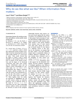

© Copyright 2026