
30 Acres +\- of Outstanding Lincoln County Farmland
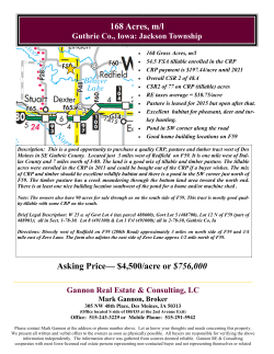
30 Acres +\- of Outstanding Lincoln County Farmland
With Single-family Building Eligibility!
ONLY 5 miles southwest of Sioux Falls!
Located: from 57th St. & 469th Ave. (Tea Rd.), go south less
than 1 mile to 269th St., then west 3 miles to SD Hwy 17, then
south 1 mile to 270th St., then less than 1 mile west.
Thursday, November 6, 2014
@ NOON
Alvin & Ruth Waldner – Owners
605-361-1699
Forrest Miller
www.soldbymiller.com
Marshall Miller
LINCOLN COUNTY LAND AUCTION!
Approx. 30 Acres of Outstanding Lincoln County Farmland
With Single-family Building Eligibility!
Located:
ONLY 5 miles southwest of Sioux Falls!
from 57th St. & 469th Ave. (Tea Rd.), go south less than 1 mile to 269th St.,
then west 3 miles to SD Hwy 17, then south 1 mile to 270th St., then less than 1 mile west.
Thursday, November 6, 2014 at NOON
Whether you’re looking for a WONDERFUL place to build your home just
minutes from Sioux Falls, or some SUPERIOR farmground, this is a GREAT
piece of land with building eligibility in a BEAUTIFUL area and location!
County records show 29.44 taxable acres. According to FSA maps and
information, this gently rolling parcel has 27.6 cropland acres including 3
acres of CRP. Nearly all tillable, the predominate soil is Class l Wentworth
silty clay loam carrying an awesome Productivity Index of 94!!!, resulting in
an EXCELLENT overall Agridata P.I. of 87.5 for the parcel! There is an 11.9
acre corn base with a 77 bu. Direct Yield and 134 bu. CC Yield along with a
12.7 acre soybean base with a 28 bu. Direct Yield and 34 bu. CC Yield with
2.8 ac. CRP reduction. Drive by this land, pick out your spot to build, and
see the beautiful crops it produces! You will have possession for 2015.
Legal: Tr.3 Hyronimus Addn. in NW¼ Sec.20-100-51 Lincoln Co., SD Taxes: $760.68
Terms: A non-refundable 10% down payment the day of the sale with the balance of
the purchase price on or before Dec. 12, 2014. Property is sold subject to owners'
confirmation, and subject to tenant’s rights, CRP, easements, restrictions, reservations
or highways of record, if any. Merle Miller Real Estate and Auction Company
represents the seller only in this transaction. All prospective buyers are encouraged to
inspect the property and verify all facts and figures provided herein. Buyers are
purchasing the above-described property strictly on an "as is" basis without warranty or
representation as to condition, value or fitness for any use or purpose. Announcements
made the day of sale will take precedence over any printed materials. For additional
information, visit our website at www.soldbymiller.com or contact Forrest Miller at
605-361-1699
Alvin & Ruth Waldner - Owner
Auctioneers:
FORREST MILLER
Broker Associate
MARSHALL MILLER
Broker
BOB HANSEN
Broker, Hanson Land & Auction
Brokers:
Merle Miller Real Estate & Auction Co.
6009 W. 41st Street, Suite 5
Sioux Falls, SD 57106
(605) 361-1699
www.soldbymiller.com
Lincoln County Property Map
October 9, 2014
1:37,391
Interstate
County Highway
Secondary Street
Sections
Water Courses
US Highway
Township Road
Parcel
StreetName
2008 Flood Plain
SD Highway
Primary City Street
Municipality
SearchSections
0
0.3
0.6
0
0.5
1
1.2 mi
2 km
Source: Esri, DigitalGlobe, GeoEye, i-cubed, Earthstar Geographics,
CNES/Airbus DS, USDA, USGS, AEX, Getmapping, Aerogrid, IGN, IGP,
Lincoln County GIS ©
Aerial Map
map center: 43° 28' 4.1, 96° 53' 45.47
scale: 13152
20-100N-51W
Lincoln County
South Dakota
10/9/2014
Field borders provided by Farm Service Agency as of 5/21/2008. Aerial photography provided by Aerial Photography Field Office.
Aerial Map
map center: 43° 28' 25.07, 96° 54' 16.04
scale: 3084
20-100N-51W
Lincoln County
South Dakota
10/9/2014
Field borders provided by Farm Service Agency as of 5/21/2008. Aerial photography provided by Aerial Photography Field Office.
Soil Map
State:
County:
Location:
Township:
Acres:
Date:
South Dakota
Lincoln
20-100N-51W
Delapre
29.43
10/9/2014
Soils data provided by USDA and NRCS.
Area Symbol: SD083, Soil Area Version: 15
Code Soil Description
WeA Wentworth silty clay loam, 0 to 2 percent slopes
Acres
Percent of field Non-Irr
Class
Irr
Class
Productivity Index Alfalfa hay Corn Soybeans
Winter
wheat
18.64
63.3%
I
94
4.8
101
38
43
EsC
Egan-Shindler complex, 6 to 9 percent slopes
5.56
18.9%
IIIe
65
3.8
68
24
31
AcB
Alcester silty clay loam, 2 to 6 percent slopes
4.08
13.9%
IIe
92
5
108
39
43
EaB
Egan silty clay loam, 3 to 6 percent slopes
0.95
3.2%
IIe
82
4.5
90
34
39
EwB
Egan-Worthing complex, 0 to 6 percent slopes
0.20
0.7%
IIIw
66
2.9
68
25
25
4.6 95.2
35.3
40.5
IIIe
Weighted Average
87.7
Area Symbol: SD083, Soil Area Version: 15
Field borders provided by Farm Service Agency as of 5/21/2008. Aerial photography provided by Aerial Photography Field Office.
4654 CRP
5
2.4&
NHEL
CRP
CRP
4654
7
0.6
NHEL
4386 5
& 0.1 NHEL
4386 1
0.2 NHEL
CRP
CRP
4654
6
24.6
)
NHEL "
4386
3
7 &
NHEL
CRP
&
CRP
4386
4
0.5
NHEL
4386
2
1.2
NHEL
CRP
CRP
&
4655
6
5.1
NHEL
CRP
4655
7
0.5
NHEL
#
*
4655
4
2
NHEL
4655
1
27.4
UHEL
4655
8
6.3
HEL
4655
9
21.3
HEL
CRP
United States Department of Agriculture
Farm Service Agency
Lincoln County, SD
1:8,200
PLSS: 20_100N_51W
Farm: 5214
Disclaimer: Wetland identifiers do not represent the size, shape or specific determination of the area.
Refer to your original determination (CPA-026 and attached maps) for exact wetland
boundaries and determinations, or contact NRCS.
2012 Ortho-Photography - Not to Scale
November 23, 2012


© Copyright 2026