
10. Place: Assessment Prepared for the
10. Place:
Assessment
Prepared for the
Airports Commission
November 2014
AIRPORTS COMMISSION
PLACE: ASSESSMENT
Disclaimer
Jacobs U.K. Limited
This document has been prepared by a division, subsidiary or affiliate of Jacobs U.K. Limited (“Jacobs”) in its professional capacity as
consultants in accordance with the terms and conditions of Jacobs’ contract with the commissioning party (the “Client”). Regard should
be had to those terms and conditions when considering and/or placing any reliance on this document. No part of this document may be
copied or reproduced by any means without prior written permission from Jacobs. If you have received this document in error, please
destroy all copies in your possession or control and notify Jacobs.
Any advice, opinions, or recommendations within this document (a) should be read and relied upon only in the context of the document
as a whole; (b) do not, in any way, purport to include any manner of legal advice or opinion; (c) are based upon the information made
available to Jacobs at the date of this document and on current UK standards, codes, technology and construction practices as at the
date of this document. It should be noted and it is expressly stated that no independent verification of any of the documents or
information supplied to Jacobs has been made. No liability is accepted by Jacobs for any use of this document, other than for the
purposes for which it was originally prepared and provided. Following final delivery of this document to the Client, Jacobs will have no
further obligations or duty to advise the Client on any matters, including development affecting the information or advice provided in this
document.
This document has been prepared for the exclusive use of the Client and unless otherwise agreed in writing by Jacobs, no other party
may use, make use of or rely on the contents of this document. Should the Client wish to release this document to a third party, Jacobs
may, at its discretion, agree to such release provided that (a) Jacobs’ written agreement is obtained prior to such release; and (b) by
release of the document to the third party, that third party does not acquire any rights, contractual or otherwise, whatsoever against
Jacobs and Jacobs, accordingly, assume no duties, liabilities or obligations to that third party; and (c) Jacobs accepts no responsibility
for any loss or damage incurred by the Client or for any conflict of Jacobs’ interests arising out of the Client's release of this document to
the third party.
Contents
AIRPORTS COMMISSION
PLACE: ASSESSMENT
Contents
Executive Summary
Land Take
Landscape, townscape and waterscape
Heritage Assessment
Waste Assessment
i
i
iii
v
vi
1
Introduction
1
2
2.1
2.2
2.3
2.4
2.5
2.6
2.7
Land Take
Context and Methodology
Methodology
Assumptions and Limitations
Assessment of Land Take Implications
Land Take Assessment - Gatwick Airport Second Runway
Land Take Assessment - Heathrow Airport Northwest Runway
Land Take Assessment - Heathrow Airport Extended Northern Runway
2
2
2
8
9
9
15
23
3
3.1
3.2
Landscape, townscape and waterscape
Context and Methodology
Landscape, Townscape and Visual Impact Assessment – Gatwick
Airport Second Runway Scheme
Landscape, Townscape and Visual Impact Assessment – Heathrow
Airport Northwest Runway
Landscape, Townscape and Visual Impact Assessment – Heathrow
Airport Extended Northern Runway
30
30
3.3
3.4
4
4.1
4.2
4.3
4.4
5
5.1
5.2
5.3
5.4
Heritage
Methodology
Heritage Assessment - Gatwick Airport Second Runway
Heritage Assessment - Heathrow Northwest Runway
Heritage Assessment - Heathrow Airport Extended Northern
Runway
Waste
Introduction and Methodology
Waste Impact Assessment - Gatwick Airport Second Runway
Waste Impact Assessment - Heathrow Northwest Runway
Waste Impact Assessment -Heathrow Extended Northern Runway
35
46
59
72
72
74
85
96
103
103
106
116
132
Appendix A Methodology and Land Use Categories
156
Appendix B Local Planning Authority GIS Information Received
169
Appendix C
Landscape and Visual Impact Assessment Methodology
170
Appendix D
Heritage Impact Assessment Methodology
179
AIRPORTS COMMISSION
PLACE: ASSESSMENT
Executive Summary
Executive Summary
This report provides a review and assessment of the three shortlisted airport
schemes against the Airports Commission’s objective of minimising impacts to
‘Place’ as defined below. The three schemes assessed are:
•
•
•
Gatwick Airport Second Runway (Gatwick 2R) promoted by Gatwick Airport
Limited (GAL);
Heathrow Airport Northwest Runway (Heathrow NWR) promoted by
Heathrow Airport Limited (HAL); and,
Heathrow Airport Extended Northern Runway (Heathrow ENR) promoted by
Heathrow Hub Limited (HH).
In April 2014, an Appraisal Framework was published by the Airport Commission
which identified the methodology that was to be used to further assess the three
shortlisted schemes, (Airports Commission, 2014a). This report has been prepared
in accordance with the Appraisal Framework and considers the environmental
implications of the proposed schemes on Place.
The sub-topics identified in the Appraisal Framework to be considered within the
assessment of Place impacts are:
•
•
•
•
Planning and land take;
Landscape, townscape and waterscape;
Heritage; and
Waste.
Each of the sub-topics is addressed as separate assessments with their own
methodology and combined within this single overall report. The assessment uses
the ‘Do Minimum’ baseline information in the Place: Baseline report, (Jacobs,
2014f).
Land Take
The land take assessment is a desk based review of the type and quantity of land
take (classified by its land use and coverage) for each of the three shortlisted airport
schemes.
This review has looked at direct land take and property loss required for the Airport
expansion areas. In addition, potential impacts from surface access construction
and flood storage areas have been considered. These areas have been defined
based on Jacobs’ assessment of the airport development footprint and surface
access requirements as provided by the scheme promoters. Areas affected by high
noise levels which could be subject to planning constraints and areas within Public
Safety Zones (PSZs) where planning restrictions apply to minimise risk to life in the
event of an airport accident have also been considered. The results of Jacobs’
assessment have been compared against the information provided by each of the
scheme promoters to identify areas of difference.
Direct land take and potential indirect land use impacts have been identified
separately. The analysis undertaken is based on the mapping shown in the
accompanying Place Figures report.
i
AIRPORTS COMMISSION
PLACE: ASSESSMENT
Executive Summary
Gatwick Airport Second Runway Land Take Assessment
The land take associated with the proposed Gatwick Airport Second Runway
(Gatwick 2R) expansion and the areas potentially affected by surface access
construction1 is estimated as 624 ha and 78.2 ha respectively.
No agricultural land within the land take area was found to be with grades 1 or 2.
Approximately 189.3 ha is ALC grade 3 and 172.9 ha is ALC grade 4, whilst the rest
is of unknown classification.
A total of 168 residential properties lie within the predicted Gatwick 2R expansion
land take and are likely to need to be demolished. An additional 37 residential
properties are within the 100m buffer that has been applied either side of the
proposed transport infrastructure routes and could potentially be lost to the surface
access improvements depending on detailed route and construction design.
Approximately 9.2ha of the proposed airport expansion for the Gatwick 2R scheme
is within designated Green Belt.
Heathrow Airport Northwest Runway Land Take Assessment
The land take associated with the proposed Heathrow Airport Northwest Runway
(NWR) airport expansion and potential land affected by surface access
construction2, is approximately 568.8 ha and 294.2 ha respectively. An additional
42.9 ha of land is identified for flood storage.
Of the potential agricultural land lost, approximately 181.5 ha is Agricultural Land
Classification (ALC) grade 1, 2 or 3 land (grade 1, 2 and 3a is considered as best
and most versatile agricultural land). An additional 19.1 ha of grade 1 and 3 ALC
land lies within the flood storage areas identified. The quality of the remaining
agricultural land is not classified.
A total of 783 residential properties lie within the Heathrow NWR airport expansion
land take and are likely to need to be demolished. An additional 289 residential
properties are within the 100m buffer that has been applied either side of the
proposed transport infrastructure routes and could potentially be lost to the surface
access improvements depending on detailed route and construction design.
Approximately 431 ha of the Heathrow NWR airport expansion is within designated
Green Belt land. As a result the development would significantly change the land
use within this Green Belt area which was designated to control urban sprawl and
maintain largely undeveloped land between urban areas.
Heathrow Airport Extended Northern Runway Land Take Assessment
The land take associated with the Heathrow Airport Extended Northern Runway
(ENR) airport expansion and potential land affected by surface access construction3
is approximately 335.7 ha and 329.8 ha respectively. An additional 57.3 ha of land
is identified for flood storage.
1
Areas potentially affected by surface access infrastructure construction are based on a 100m buffer
area defined either side of each route; this is intended as an indicative area appropriate for this
strategic stage given uncertainties in route alignment, design and construction approaches.
2
As above.
3
As above.
ii
AIRPORTS COMMISSION
PLACE: ASSESSMENT
Executive Summary
Of the potential agricultural land lost, approximately 69.1 ha is ALC grade 1, 2 or 3
land (grade 1, 2 and 3a are considered best and most versatile land) and the
classification of the remaining area is unknown. In addition, a further approximately
27 ha of grade 1 to 3 land lies within the flood storage areas.
A total of 242 residential properties lie within the airport land take and are likely to
need to be demolished. An additional 165 residential properties are within the 100m
buffer that has been applied either side of the proposed transport infrastructure
routes and could potentially be lost to the surface access improvements depending
on detailed route and construction design.
Approximately 278.2 ha of proposed the Heathrow ENR airport expansion is within
designated Green Belt and would significantly affect the aims of the Green Belt in
this area to control urban sprawl and separate maintain largely undeveloped land
between urban areas.
Landscape, townscape and waterscape
The landscape, townscape and waterscape assessment considers the potential
effects on the landscape, townscape, visual amenity, tranquillity and dark skies as a
result of the three shortlisted airport schemes. The assessment was undertaken
using the Guidelines for Landscape and Visual Impact Assessment, Third Edition,
(Landscape Institute and Institute of Environmental Management and Assessment,
2013).
For tranquillity impacts, predicted N70 (20 event) noise contours were overlaid onto
tranquillity mapping and compared for the ‘Do Minimum’ and ‘Do Something’ options
for each of the three proposed schemes.
For all three schemes, the most significant effects on the landscape, townscape and
visual amenity would be experienced during construction. This is due to the loss of
landscape or townscape features and the visual intrusion of construction activity.
Effects often reduce on the completion of construction, although for some receptors
a significant adverse effect would remain.
For all three schemes, there is the potential for some areas to experience a
reduction in tranquillity due to the increased area of flight paths associated with the
new runway. There is also the potential for increased light levels but this is unlikely
to alter the results of the CPRE Dark Skies mapping given the existing conditions.
Mitigation measures proposed by the promoters have been taken into account in the
assessment and the beneficial effects of this mitigation reflected in the overall
conclusion of assessment.
Gatwick Airport Second Runway Landscape Assessment
For the Gatwick 2R Scheme, the West Sussex: LW8 Northern Vales character area
would be the only landscape or townscape area to experience a significant adverse
effect as the majority of construction works would take place here. This construction
impact would result in a permanent loss of landscape features and so the significant
adverse effect would continue into the operation of the airport.
Ifieldwood, B2036 and Radford Road properties, Crawley public rights of way and
the Tandridge Border Path would experience a significant adverse effect on views
during construction, due to their proximity to the works and open views. The
significant adverse effect would continue into the operation of the airport for
iii
AIRPORTS COMMISSION
PLACE: ASSESSMENT
Executive Summary
Ifieldwood and the Tandridge Border Path as the receptors would have relatively
open views towards the operational site, with little scope for mitigation.
Heathrow Airport Northwest Runway Landscape Assessment
For the Heathrow NWR scheme the Colne Valley Regional Park would experience a
significant adverse effect during construction as some of the park would be lost to
accommodate the new runway and there would be views from the park towards the
construction works. The park would conversely experience a beneficial effect,
although not significant beneficial effect during operation as there are extensive
mitigation measures proposed by HAL which would help to improve the quality and
appearance of the remaining park close to the airport.
The Hillingdon Lower Colne Floodplain character area would experience the most
significant adverse effect in terms of landscape and townscape character as the
majority of construction works would take place here. There would also be a
significant adverse effect on Hillingdon Open Gravel Terrace character area, Slough
Road Infrastructure character area and the Hillingdon Historic Core character area,
due to physical changes for airport infrastructure and a reduction in visual amenity.
The loss of landscape features would be permanent for the Hillingdon Lower Colne
Floodplain and so the significant adverse effect would continue into the operational
phase of the airport. There would also be a significant adverse effect on Hillingdon
Historic Core due to the permanent loss of Longford village and part of
Harmondsworth.
Properties in Stanwell, Stanwell Moor, Harmondsworth and Sipson would all
experience a significant adverse effect on views during construction due to the
proximity of works and the open nature of views. The significant adverse effect
would continue into the operation of the airport for properties in Harmondsworth and
Sipson. This is because the operational airport would be in very close proximity and
although partially screened by bunding, the bunding itself would have a visual
impact.
Public rights of way south of the M4, including the Colne Valley Way, and
Harmondsworth Moor would also experience a significant effect on views during
construction of Heathrow NWR. This is because these areas would have close
range views towards construction works. The significant adverse effect would not
continue into the operational phase for these receptors. Conversely, public rights of
way south of the M4 would experience a beneficial effect, although not significant
beneficial effect during operation as the extensive mitigation measures proposed by
HAL would improve the setting of the public rights of way and help screen views of
the airport.
Heathrow Airport Extended Northern Runway Landscape Assessment
For the Heathrow ENR scheme the Colne Valley Regional Park would experience a
significant adverse effect during construction as some of the park would be lost to
accommodate the new runway and there would be views from the park towards the
construction works. The park would not experience a significant adverse effect
during operation as mitigation measures would help to offset adverse effects from
the new runway and associated airport infrastructure.
The Hillingdon Lower Colne Floodplain character area would experience the most
significant adverse effect in terms of landscape and townscape character as the
majority of construction works would take place here. There would also be a
significant adverse effect on the Windsor and Maidenhead Settled Developed
iv
AIRPORTS COMMISSION
PLACE: ASSESSMENT
Executive Summary
Floodplain character area and the Hillingdon Historic Core character area due to
physical changes resulting from airport infrastructure and a reduction in visual
amenity. For Hillingdon Lower Colne Floodplain where loss of landscape features
would be permanent the significant adverse effect would continue into the operation
of the airport.
Properties in Stanwell, Stanwell Moor, Colnbrook, Horton and Longford and the
Poyle Industrial Estate would all experience a significant adverse effect on views
during the construction of Heathrow ENR due to the proximity of works and the open
nature of views. The significant adverse effect would continue into operation for
properties in Colnbrook, Horton and Longford. This is because the operational site
would be a dominant feature in their view with limited scope for mitigation.
The Colne Valley Way and Wraysbury Reservoir would also experience a significant
effect on views during construction, particularly the Colne Valley Way which would
be adjacent to the works for the new runway. For the Colne Valley Way the
significant adverse effect would continue into the operational phase of the airport
due to the proximity of the operational runway and the open views towards it.
Heritage Assessment
The heritage assessment focuses on designated heritage assets, namely Scheduled
Monuments, Listed Buildings, Conservation Areas, Registered Parks and Gardens,
and World Heritage Sites that could be affected, potential mitigation and residual
impacts.
Heritage assets were identified from existing data sources including the National
Heritage List and the assessment methodology used was based on national
heritage guidance, and in particular the methodology contained in the Design
Manual for Roads and Bridges Volume 11, Section 3 Part 2 Cultural Heritage (HA
208/07), (DMRB, 2010). For tranquillity impacts, predicted N70 (20 event) noise
contours were compared for ‘Do Minimum’ and ‘Do Something’ options for each of
the proposals to identify designated heritage assets where impacts on their
tranquillity could occur from aircraft noise as a result of increases or other changes
in air traffic.
Gatwick Airport Second Runway Heritage Assessment
The assessment of the Gatwick 2R scheme identified 22 potential impacts on
designated assets within the scheme land take, the setting of a further ten
designated heritage assets could be affected within 300m of the scheme area and
from 300m to 2km the setting of a further 160 designated assets could potentially be
affected.
Heathrow Airport Northwest Runway Heritage Assessment
For the Heathrow NWR scheme 21 potential impacts were identified within the
scheme land take, the setting of 54 designated heritage assets could be affected
within 300m of the scheme area and from 300m to 2km the setting of a further 166
designated assets could potentially be affected.
Heathrow Airport Extended Northern Runway Heritage Assessment
For the Heathrow ENR scheme seven potential impacts were identified within the
scheme land take, the setting of 30 designated heritage assets could be affected
v
AIRPORTS COMMISSION
PLACE: ASSESSMENT
Executive Summary
within 300m of the scheme area and from 300m to 2km the setting of a further 168
designated assets could potentially be affected.
Waste Assessment
This assessment considers how waste would be managed both during construction
of each option and operationally for each of the shortlisted airport options. The
approach focuses on three elements:
1. An assessment against modelled waste forecast scenarios for ‘Do Minimum’
and ‘Do Something’;
2. The potential impacts during the construction phase; and
3. The potential impacts during the operational phase.
Operational waste projections within each submission have been assessed against
waste forecasts calculated by Jacobs, based on waste generation levels (i.e.
kg/passenger).
The growth scenarios modelled for each airport are summarised in Table D. They
reflect the different starting points and the different waste generation levels used to
forecast operational waste. Along with the growth scenarios, different recycling
performance levels were modelled to show the tonnage of material that could be
recycled in the future. The resultant waste/passenger factors were then applied to
the passenger number forecasts in the Assessment of Need (AoN Carbon Capped)
projections provided by the Airports Commission, (Airports Commission, 2014b).
Table D - Waste Growth Scenarios
Waste Growth Scenario
Heathrow
Gatwick
1: No change in waste/
passenger from most recently
reported data
No growth in waste/passenger,
with the figure remaining at the
2013 level of 0.369
kg/passenger.
No growth in waste/passenger,
with the figure remaining at the
2012 level of 0.260
kg/passenger.
2: Waste prevention based on
the average reduction in waste/
passenger over recent years
The average growth rate
between 2008 and 2013 of
minus 3.7% per annum
continues until 2020, then 0%
growth
The average growth rate
between 2008 and 2012 of
minus 8.7% per annum
continues until 2020, then 0%
growth
3: Waste prevention using a
more conservative waste
reduction assumption than that
experienced over recent years.
A growth rate of minus 2% per
annum until 2020, then 0%
growth
A growth rate of minus 2% per
annum until 2020, then 0%
growth
The waste assessment was undertaken for the operational phase only. However,
likely construction and demolition (C&D) waste arisings were estimated for the
purpose of comparison against C&D forecasts provided by each of the scheme
promoters. The approach considered the application of available industry
benchmark data, including use of generic resource benchmarks for different types of
construction projects.
Due to the considered low levels of robustness of available benchmark data, and the
limited application to the proposed airport schemes, it is considered inappropriate at
this stage to include any quantified assessment of likely construction waste
forecasts for each of the schemes.
vi
AIRPORTS COMMISSION
PLACE: ASSESSMENT
Executive Summary
Gatwick Airport Second Runway Waste Assessment
There is a notable difference in passenger number projections, with the Gatwick
Airport Limited (GAL) submission estimating approximately 40% higher passenger
numbers over the headline years (the GAL submission forecast is 65Mppa by 2030
and 95Mppa by 2050, compared with the Airports Commission’s Assessment of
Need Carbon Capped (AoN Carbon Capped) scenario 2014, of 46Mppa in 2030 and
69Mppa by 2050), (Airports Commission, 2014b). The GAL submission estimates
higher operational waste arisings with 16,250 tonnes of operational waste arising by
2030 compared with the Jacobs ‘Do Something’ estimates of 12,000 tonnes by
2030, (Scenario 1). This is due to the differences in forecast passenger numbers.
GAL’s projection of 0.25 kg waste per passenger is within the range considered
reasonable and utilised in the Jacobs waste forecast. Compared against the Jacobs
2050 forecasts for ‘Do Minimum’, the Gatwick 2R scheme would result in an
increase in operational waste of between 100% (Scenario 1) and 400% (Scenario
2).
The approach for identification and management of construction and operational
waste outlined by the scheme promoter is well considered, and adopts the principles
of the waste hierarchy. GAL assumes (based on previous construction projects) a
recycling rate of 96% of construction waste will be achieved, with the remaining 4%
destined for disposal or recovery off-site. This relies on there being sufficient
local/regional treatment capacity for at least 60,000 tonnes of construction and
demolition waste that is likely to contain hazardous substances. In the context of
wider construction and demolition waste arisings from development, projected for
the South East over this development period, arisings from Gatwick 2R are less
significant.
Some of the treatment routes identified for operational waste arisings from the
proposed development have yet to be installed. In particular, the energy from waste
(EfW) capability and a separate anaerobic digestion (AD) plant for processing
organic/food waste (referred to in the GAL submission) are both still proposed
developments. Consent and subsequent development of major waste facilities has
been subject to challenge during planning stages and therefore delivery of these
facilities cannot be guaranteed. It is suggested that an assessment is carried out
into the level of off-site energy recovery and organic waste processing capacity
available, should either of these developments prove not to be economically viable,
or encounter problems with either planning or permitting consent.
Heathrow Airport Northwest Runway Waste Impact Assessment
The Heathrow Airport Limited (HAL) submission predicts the number of passengers
moving through the airport following the runway development to be in the region of
103mpppa in 2030, 130Mppa in 2040 and 135Mppa in 2050, which compares
favourably with Airports Commission Demand Forecasts over these same headline
years (a slight difference for the year 2030). HAL forecasts 46,000 tonnes of
operational waste arisings by 2040, which is consistent with Jacobs ‘Do Something’
estimates of 47,000 tonnes (Scenario 1) for 2040.
The overall approach to management of waste during the operational phase of the
third runway outlined within the HAL submission, particularly beneficial use of
wastes and application of the waste hierarchy, is forward thinking and in line with
national good practice. The application of solutions which reduce waste at source
vii
AIRPORTS COMMISSION
PLACE: ASSESSMENT
Executive Summary
and increase levels of recycling appear to be appropriate, however the assumptions
have not been substantiated and are therefore subject to a level of uncertainty.
As a result of reviewing the HAL submission against the Appraisal Framework
provided by the Airports Commission, (Airports Commission, 2014a) it is considered
that the scheme promoters have considered construction wastes associated with the
development but only in outline. A lack of construction waste arisings forecasts
means that proposals for managing waste materials effectively and sustainably are
generic.
Proposals by HAL to develop a revised plan which seeks to keep the site for the
replacement EfW plant as close to its existing location as possible is likely to ensure
that impacts of road traffic movements from waste will be similar to existing traffic
impacts (although traffic movements will increase as a consequence of increased
operational waste being taken off-site). HAL has also provided an updated plan,
which shows the location of the EfW re-provision, however it is not possible to
determine the dimensions of the proposed location from this plan. Confirmation of
the size and suitability of the site identified for re-provision would need to be
confirmed should the scheme progress.
Heathrow Airport Extended Northern Runway Waste Impact Assessment
Heathrow Hub (HH) forecast passenger numbers for 2050 as being 130Mppa, which
compares favourably against Airports Commission’s AoN Carbon Capped scenario
2014, of 129Mppa in the same year (taking into account limitations of waste data
presented by HH), (Airports Commission, 2014b). Similarly, HH forecasts 48,000
tonnes of operational waste arisings by 2050, which is identical to Jacobs ‘Do
Something’ estimates of 48,000 tonnes (Scenario 1). Compared against the Jacobs
‘Do Minimum’ scenario forecasts, the HH scheme would result in an increase in
operational waste of between 60-85% (Scenario 1- 3).
The broad approach described by HH to managing waste on the scheme is
consistent with the waste hierarchy and there are examples of good practice for
reducing and recycling waste. However, the absence of site-specific information
has resulted in a submission that is generic, with limited detail.
At this stage of the process, the scheme promoter has provided insufficient detail
relating to proposed plans and strategies for managing construction and operational
wastes to determine whether these will be effective in mitigating the environmental
impacts of waste management on place. There is limited evidence on how the
targets proposed for waste management can be met. Construction and demolition
forecasts and construction wastes for each element of the development are limited,
with no supply/demand assessment for recycling/composting waste management
capacity supplied as evidence of what facilities will be required on and off-site.
Whilst a Construction Environmental Plan is proposed, it is largely limited to water
impacts; therefore it is not possible to conclude if waste impacts will successfully be
mitigated. Neither does the submission contain a contamination assessment. Should
the HH scheme progress is suggested that geo-technical investigations are
undertaken and a MMP and WMP (supported by detailed waste forecasts, a facility
capacity review and the identification/mitigation of environmental impacts of waste
management) are prepared, to enable the impact of waste management on place to
be more meaningfully assessed.
viii
Chapter 1
AIRPORTS COMMISSION
PLACE: ASSESSMENT
Introduction
1
Introduction
The Place module of the Airports Commission’s Appraisal Framework includes
an assessment of:
•
Land Take;
•
Landscape, Townscape and Waterscape;
•
Heritage; and
•
Waste.
This report provides a review and assessment of the three shortlisted airport
schemes against the Airports Commission’s objective of minimising impacts to
‘Place’ as defined below. The three schemes assessed are:
•
•
•
Gatwick Airport Second Runway (Gatwick 2R) promoted by Gatwick Airport
Limited (GAL);
Heathrow Airport Northwest Runway (Heathrow NWR) promoted by
Heathrow Airport Limited (HAL); and
Heathrow Airport Extended Northern Runway (Heathrow ENR) promoted by
Heathrow Hub Limited (HH).
In April 2014, an Appraisal Framework was published by the Airport Commission
which identified the methodology that was to be used to further assess the three
shortlisted schemes. This report details the Place assessment and has been
prepared in accordance with the Appraisal Framework. The assessment uses the
baseline information provide in the Place: Baseline report, (Jacobs, 2014f)
The sub-topics identified in the Appraisal Framework to be considered within the
assessment of Place impacts are:
•
•
•
•
Planning and Land Take;
Landscape, Townscape and Waterscape;
Heritage; and
Waste
For each topic there is an explanation of the methodology and study area used in
the assessment, the assumptions and limitations within the assessment and an
assessment divided into four sections one for each of the proposed airport schemes.
The structure of the report is:
•
•
Chapter 1 introduces the report and content of the ‘Place’ assessment.
Chapters 2 to 5 provide the assessment for each of the topics within the
‘Place’ assessment.
1
Chapter 2
AIRPORTS COMMISSION
PLACE: ASSESSMENT
Land Take
2
Land Take
This section presents the land take assessment within the Appraisal Framework
for Place. This includes consideration of:
•
•
•
The potential land take from each proposed scheme;
The land uses potentially affected; and
Land uses and properties numbers within land affected by increased
noise and also within public safety zones.
2.1 Context and Methodology
The Land Take appraisal of the three proposed airport schemes is based on the
requirements of the Airports Commission Appraisal Framework, (Airports
Commission, 2014a). This states that the airport proposals should be assessed in
terms of:
‘’…the type and quantity of land developed (classified by its use and cover), and
the direction and magnitude of the impacts of changing land use’’
In relation to land use categorisation to be used in the assessment, the Appraisal
Framework states that:
“The type of land that will be developed will be classified by its land use and cover.
This classification can be based on the National Land Use Database (NLUD),
which categorises land as follows: agriculture and fisheries, forestry, minerals,
recreation and leisure, transport, utilities and infrastructure, residential, community
services, retail, industry and business, vacant and derelict, defence and unused
land.” (Airports Commission, 2014a).
This report therefore focusses upon the direct impacts of land take for airport
expansion and for surface access, the land potentially affected by construction. It
also includes consideration of ‘indirect’ impacts which could have implications for
future land uses.
The outputs of this report are a quantitative assessment of the land take impacts of
the shortlisted schemes, with additional commentary on the magnitude and
direction of land use change. The results of the Jacobs assessment have then
been compared against the information provided by each of the scheme promoters
to identify areas of difference.
The Appraisal Framework also refers to the ‘urbanisation’ effect of the proposals
and such impacts, along with landscape and townscape considerations, (Airports
Commission, 2014a). These are considered in the Assessment of Landscape,
Townscape and Waterscape Impacts section of this report.
2.2 Methodology
To understand the current use of land affected by each proposal, data was
collected and mapped from the sources set out below. Existing land use mapping
is provided in the Place Baseline Report, (Jacobs, 2014f).
2
Chapter 2
AIRPORTS COMMISSION
PLACE: ASSESSMENT
Land Take
2.2.1 Inputs
Airport expansion and surface access information
For each of the three submissions, the additional land area required for the airport
expansion is based on the airport footprint provided in a CAD digital form by the
scheme promoter as part of its submission. This information was analysed by
Jacobs and an airport expansion outline area generated to include all the related
airport development indicted by the proposers. Some adjustments were made to
ensure consistency and to take account of additional promoter identified areas
around the perimeter of the airport involving land take. Land Take Figures are
contained within accompanying Place Figures report.
Gatwick 2R: the airport footprint is based on the promoter’s expansion area
provided and includes related ancillary development and flood storage areas and
balancing ponds within the outline area.
Heathrow NRW: the airport footprint is based on the outline provided for the
expansion area for the proposed runway development but also includes the
additional areas of land take around the existing airport which the promoter has
indicated as being required for the scheme development and the areas of land
take indicated for flood storage use located within the compensation land area.
Heathrow ENR: the airport footprint includes the expansion areas for the proposed
runway extension as provided by the promoter, with the addition of a possible
location for balancing ponds to the south of the airport footprint.4 Flood storage
areas are indicated separately in the HH submission, and have also been included
in the land take assessment. The Heathrow Hub interchange has been excluded
from the footprint and the assessment. The Commission stated in its Interim
Report its intention to consider HH’s proposed transport hub as a detachable
component which could be associated with either of the Heathrow runway options
under consideration. Accordingly, the core appraisal case for the Heathrow ENR
option includes a more traditional surface access package, whose rail components
are identical to those proposed by Heathrow Airport Limited, but whose road
components have some variations to junctions and access road layouts to reflect
the different configuration of the airfield site.
For all three schemes, additional areas of potential land take impact for surface
access infrastructure construction have been estimated by Jacobs based upon the
details of routes for new infrastructure or capacity improvements provided within
the promoter submissions. An indicative 100m buffer has been applied either side
of the route locations to cover potential land take associated with the construction
works. The actual land take required for surface access purposes is likely to
change in the future with the emerging detailed design, and in many cases is likely
to be less than the indicative 100m applied each side for the purpose of this
assessment and in some instances the impact may be limited to one side of the
highway. However, in some cases the impact it could potentially be more. The
100m buffer is considered an acceptable approach at this strategic stage of
assessment given the uncertainty over final alignment and the approach to
construction.
4
The HAL submission for Heathrow NWR includes an area at this location near to the existing airport boundary
and a similar requirement may be required for the Heathrow ENR development however, as the site identified
by HAL would be within the footprint of the airport expansion area for Heathrow ENR, the balancing ponds for
Heathrow ENR have been located just south of the Heathrow NWR pond location.
3
Chapter 2
AIRPORTS COMMISSION
PLACE: ASSESSMENT
Land Take
Areas identified for compensation habitat or recreation provision are not included
in the land take assessment where these are additional to the airport development
footprint (these are considered in the Assessment of Biodiversity Impacts, Jacobs
2014b).
Land use information
For the land use categories in this report, data was obtained from The Geo
Information Group (GIG), as this was the most complete and detailed GIS Land
Use data that was available. The associated land use categories were then
rationalised to fit with the established National Land Use Database (NLUD)
categories in order to match the land use descriptions as closely as possible (see
Appendix A for details of the land uses categories rationalisation). It was
considered preferable to present the data in the form of NLUD categories, rather
than retaining the GIG categories, as NLUD is the nationally recognised format for
land use data and to present it in this way is consistent with the guidance in the
Commission Appraisal Framework, (Airports Commission, 2014a). Consequently
the impact upon the following NLUD land uses forms the basis of this report:
•
•
•
•
•
•
•
•
•
•
•
Agricultural land (categorised
Classification – see below);
Forestry;
Minerals;
Recreation and leisure;
Transport;
Utilities and infrastructure;
Residential;
Community services;
Retail;
Industry and business; and
Unused land.
according
to
its
Agricultural
Land
Water bodies are included within the most suitable category depending on the use
identified in the GIG data either in recreation and leisure, reservoir use in utilities
and infrastructure or if use is unspecified as unused land (see Appendix A). The
NLUD ‘Vacant and Derelict’ land and ‘Defence’ land is not identified under these
categories in the GIG data.
Agricultural Land Quality
Department for Environment, Food and Rural Affairs (Defra) Agricultural Land
Classification (ALC) data was used to identify the quality of the agricultural land.
The ALC system classifies land into five grades based on the potential for
agricultural production: Grade 1 (excellent); Grade 2 (very good); Grade 3 which
subdivided into Subgrades 3a (good) and 3b (moderate); Grade 4 (poor) and
Grade 5 (very poor). Policy guidance defines ‘best and most versatile’ land as
Grades 1, 2 and 3a. This is the land which is most flexible, productive and efficient
in response to inputs and which can best deliver future crops for food and non-food
uses such as biomass, fibres and pharmaceuticals (Note: Grade 3 land is
however, not subdivided in to 3a and 3b for the strategic level mapping that the
GIG data is based on and actual quality grade would need to be determined
through detailed survey).
The ‘Unknown’ classification results from where areas of agriculture land as
defined by the GIG overlap with non-agricultural as defined by the ALC. This
discrepancy can be accounted for due to the varying definitions of agricultural land
4
Chapter 2
AIRPORTS COMMISSION
PLACE: ASSESSMENT
Land Take
between the NLUD, GIG and ALC datasets. For example, in the NLUD agricultural
(and fisheries) land can include cropland, grassland or fallow land; orchards and
other cultivated trees; land use for horticulture; all ancillary land; unimproved or
improved grasslands; and associated buildings (National Land Use Database:
Land Use and Land Cover Classification, 2006). ALC definitions vary with this and
do not include agricultural buildings, and soft land (land not used for agricultural
but “could be easily returned to agriculture”) which fall within Section U011 of land
use for agriculture (NLUD, 2007).
GIG Data
Like all land use data, the GIG data is not 100% accurate, but it was considered to
be the best source of data available for this appraisal. It is noted that the
predominant use for an area of land is often selected in the data, meaning that
ancillary or subordinate uses are not necessarily identified, for example there were
few specific ‘community land uses’ included within the GIG dataset.
Address Base Plus Point Data
Additional property number data was secured from the ‘Address Base Plus Point
Data’ dataset in order to provide a ‘finer grain’ of detail in terms of land uses
(specific properties and facility locations rather than site coverage areas). The data
is arranged by main category groups and subdivided further. The categories
chosen to focus on to supplement the land use data were residential, educational,
community services, places of worship, parks, and allotments, given their potential
sensitivity.
Local Planning Authority Data
Additionally, GIS data was requested from all the Local Planning Authorities (LPA)
that were potentially affected by the three airport submissions in order to enable an
assessment of land take in terms of the effect on higher level policy designations.
Information was sought in respect of:
•
•
Local development plan allocations; and
Green Belt planning designations.
Public Open Space (POS) has legal protection and should be replaced if lost. The
identification of POS was initially considered as part of this assessment, but has
not been included as there was not sufficient meaningful or complete data
available. In this respect, it was considered that the data was likely to be
incomplete due to the potentially large numbers of sites of all shapes and sizes,
which would not all be identified in local plans. Also, there was an apparent lack of
consistency in respect of the definition of POS between each local planning
authority. It may be possible to identify precise areas of POS affected within each
LPA in a separate exercise, but this would be likely to involve detailed discussions
with each LPAs individually. Notwithstanding this, the GIG data has identified
recreational areas, some of which are likely to be areas of POS. Address Point
data also identifies numbers of parks, which are potentially POS.
Noise level information
Noise contour information for the each of the schemes has been generated by
modelling work undertaken by the Civil Aviation Authority (CAA)’s Environmental
Research and Consultancy Department (ERCD) on behalf of the Commission. This
covered baseline ‘without scheme’ noise contours for 2030, 2040 and 2050 and
‘with scheme’ noise contours for 2030, 2040 and 2050.
5
Chapter 2
AIRPORTS COMMISSION
PLACE: ASSESSMENT
Land Take
As the National Planning Policy Framework (NPPF), the National Policy Statement
for England (NPSE) and the new Practice Guideline on Noise do not relate
planning policy guidance to specific noise levels, we have used the 63 LAeq 16hr
noise contour level as an indicative level within which local authorities might apply
restrictions or conditions on new development. The selection of this contour is
informed by the now rescinded PPG 245, as this identified the 63 LAeq 16hr noise
contour as the level where aviation or mixed source noise would need to be
considered within a planning application.
The use of the 63 LAeq16hr noise contour was considered appropriate for this
analysis to indicate where land use implications from noise are most likely to
occur. Therefore, the area outside the airport footprint boundary but within the
noise contour may be subject to limitations on the type of development in line with
NPSE/NPPF guidance although this is not a specific restriction.
Public Safety Zone information
Public Safety Zones (PSZs) are areas of land at the ends of the runways at the
busiest UK airports within which development is restricted in order to control the
number of people on the ground at risk of death or injury in the event of an aircraft
accident on take-off or landing. The PSZs for the new runways have been
determined by Jacobs PSZs based on risk contours.
Government policy, as set out in DfT circular 01/10, (DfT, 2010) is to ‘avoid an
increase in the number of people living, working or congregating in Public Safety
Zones and that, over time, the number should be reduced as circumstances allow’.
The circular annex also sets out the general presumption against new
development within PSZ and details potential permissible development. The
annex also set out expectations for airports to offer to purchase property within
specified risk levels.
2.2.2 Method
The analysis covers:
1) Direct land take areas - land potentially lost to the development. These areas
are subject to direct land use change within development area boundaries
including:
•
•
•
5
Airport expansion areas;
Surface access infrastructure capacity improvements. (This includes a
100m buffer that has been applied either side of proposed transport
infrastructure routes for potential construction impacts. Although not of all
this land may be required following detailed design of routes and
construction, this buffer is intended to covers areas most likely to be at
risk); and
Flood storage areas (where these are additional to the outline for the
airport expansion area).
Noise planning policy guidance note, PPG24, set out Noise Exposure Categories (NEC) for aircraft
noise to guide planning decisions. NEC category B was the noise level range where noise should
be taken into account in planning and conditions applied in order to provide protection against
noise. NEC category C was the range at which planning permissions would not normally be granted
without specific reasons and protection. PPG24 has now been superseded by the National Policy
Planning Framework (NPPF).
6
Chapter 2
AIRPORTS COMMISSION
PLACE: ASSESSMENT
Land Take
It may be possible that a specific land use within the development footprints is
retained where it can be incorporated within the development design for
example, as part of mitigation proposals.
For the airport development and surface access land take the following
analysis is provided for each airport scheme:
•
•
•
•
•
Land loss by land use type using the GIG database ;
Agricultural land loss by land quality grade based upon areas for each
Agricultural Land Classification (ALC) grade;
Local Planning Authority land use allocations;
Green Belt designated land; and
Property numbers by category (from the Address point data).
2) Land areas outside the direct land take could be subject to indirect land use
change over time as a result of planning restrictions due to health or safety
reasons. This element of the analysis considered:
• Land within the 63 LAeq16hr noise contour6 associated with the airport
expansion: and
• Public safety zones (PSZs) at the proposed runway ends, outside the
proposed development land take. This is where new development would be
subject to planning restrictions.
3) Comparison of Jacobs’ findings with the scheme promoter’s information;
including comments on where the Jacobs’ assessment supports the promoter’s
submission information, where there are differences and the likely reasons for
any differences.
Whilst not considered in this report, it should be noted that land uses around the
airport (beyond the areas identified in this assessment of areas of direct land take)
are likely to be indirectly affected in the medium to long term by the opportunities
afforded by proximity to the airport and also how local authority land allocations
and markets respond to these opportunities.
2.2.3 Mitigation
Land take related to an airport expansion could have negative impacts upon
existing land uses and this will need to be addressed in any development of a
proposed scheme. This response can either be in terms of mitigation or
compensation (or potentially a combination of the two).
In assessing the land take implications the main impacts likely to require mitigation
relate to:
•
•
the loss of recreational land; and
the loss of other community facilities.
To comply with planning policy an effect upon Green Belt would need to be
justified by arguing that the associated development is ‘appropriate’ or by providing
6
Noise contours for 2030 with development modelled by ERCD for the CAA (2014) on behalf of the
Airports Commission and based on the least number of total people affected carbon capped
scenario.
7
Chapter 2
AIRPORTS COMMISSION
PLACE: ASSESSMENT
Land Take
‘very special circumstances’ that justify the impact upon the Green Belt. This
reflects that it is not normally possible to compensate for the loss of Green Belt
land by provision of alternative land elsewhere due to the location-specific nature
of the designation and its purposes.
As a result of the nature of the impact the loss of agricultural land, residential and
commercial properties would usually be compensated for rather than mitigated
against. This is usually in the form of financial compensation, though in some
cases it may be possible that alternative sites for re-location of the use could be
found.
In relation to mitigation and compensation for loss of biodiversity habitat and
indirect impacts on biodiversity as a result of the proposed airport schemes, this is
covered in the Biodiversity: Assessment Report, (Jacobs 2014e). The Local Noise
assessment (Jacobs, 2014g) addresses impacts from noise on people rather than
the land use aspects covered in this report.
Notwithstanding this, it is considered that a detailed appraisal of appropriateness
of the land take mitigation/compensation will need to be considered at more
detailed planning stages and not at this ‘high level’ stage.
2.3 Assumptions and Limitations
Key assumptions for the assessment are:
•
•
•
The land use data from Geo-information Group and the local authorities’
data is accurate, comprehensive and current and that the Address Base
Plus Point Data is used to add detail to these data sources (which should
take prominence in case of a conflict);
For the purposes of this report, the data is assumed to be relevant to the
target date for new runway opening in 2025 or 2026, with development plan
allocations coming forward; and
No significant change to land uses within the land take areas, outside those
reflected in local development plan allocations, prior to the new runway
opening.
Key exclusions and limitations for the assessment are:
•
•
•
•
•
It should be noted that not all GIS data layers from LPAs have been
received nor verified with the LPAs concerned. Appendix C identifies the
situation regarding data requested and received from the relevant LPAs;
No assessment of existing and possible future planning permissions has
been undertaken as part of this high level assessment;
No consideration has been given in this high level assessment to the
potential for further land use changes due to severance effects, for
example where remaining land uses become isolated or unviable and
mitigation options are limited (this can be quite a complex and detailed
process, which we would recommend is undertaken as part of a separate
exercise);
Fragmentation of the land uses in the long term could also be affected,
however due to the strategic scope of this study, this needs to be
addressed properly in later, detailed studies;
Public Open Space (POS) has not been specifically identified (see section
2.2.1) and although the Address Point data identifies POS along with
8
Chapter 2
AIRPORTS COMMISSION
PLACE: ASSESSMENT
Land Take
•
•
•
nature reserves under a ‘Parks’ category, the definition used for identifying
POS and nature reserves is not clear;
In terms of how the baseline land use will develop in the future, it is not
known at this stage what level of growth is likely beyond the end date of
current development plans, which will typically run up to the year 2030.
Future trends in the next series of development plans will be influenced by
the need for climate change adaption and a level of development pressures
for more housing, business use, infrastructure and other uses. The future
without new runway scheme proposals is described further in the Place
Baseline Report (Jacobs, 2014f);
No predictions of land use change outside the local development
allocations have been made, although a number of drivers for change are
identified in the baseline report; and
It is likely that there will be changes in planning policy, in future local
authority development plans, and future market conditions are also difficult
to predict by the time the new runway opens. Both these factors can
influence land use change, but at this high level stage no forecasts are
made.
2.4 Assessment of Land Take Implications
This assessment of land take includes:
•
•
•
•
•
•
The land uses affected by each scheme, the associated land take and land
affected areas and the numbers of properties/facilities affected (in certain
cases);
Agricultural Land quality implications;
Green Belt implications;
Property types within land take area;
Land uses and properties numbers within land affected by increased noise
and also within public safety zones; and
Comment on the Promoter’s submission information
2.5 Land Take Assessment - Gatwick Airport Second Runway
2.5.1 Land Use
The land uses affected by the Gatwick 2R scheme are shown on Land Take Figure 2 in the accompanying Place Figures report and the total land take for
airport expansion and surface access area potentially affected, is calculated as
approximately 624ha and 78.2 ha respectively.
Table 2.1 sets out the land take by land use classification as a result of the
Gatwick 2R proposal. It shows the land use, the gross amount of land taken in
hectares (ha) and the local authorities affected. Flood storage areas are integrated
within the airport land take area and are therefore not measured separately.
9
Chapter 2
AIRPORTS COMMISSION
PLACE: ASSESSMENT
Land Take
Table 2.1 - Land Take – Gatwick 2R
Land Use
Agricultural
and Fisheries
land
SUB-TOTAL
Forestry
SUB-TOTAL
Minerals
Recreation
and leisure
(incl. open
space)
SUB-TOTAL
Transport
SUB-TOTAL
Utilities and
infrastructure
Residential
SUB-TOTAL
Community
services
SUB-TOTAL
Retail
SUB-TOTAL
Industry and
business
SUB-TOTAL
Unused land
SUB-TOTAL
TOTAL
381.9 ha
Potential Land
Affected
(Surface
Access) (ha)
39.4 ha
54.8 ha
9.1 ha
NA
31.8 ha
NA
0.3 ha
29.0 ha
20.6 ha
NA
NA
56.4 ha
8.3 ha
0.9 ha
NA
6.8 ha
NA
51.4 ha
0.1 ha
11.0 ha
0.4 ha
624 ha
78.2ha
Land Take
(Airport
Expansion (ha)
Breakdown of Land Take by Local
7
Authorities (ha)
Crawley District – 292.3 ha (up to 296.9
ha)
Horsham District - 83.8 ha
Mole Valley District - 5.9 ha
Reigate & Banstead District – 0 (up to
16.1 ha)
Tandridge District – 0 (up to 18.6 ha)
381.9 ha (up to 421.3 ha)
Crawley District – 39.2 ha (up to 40.5
ha)
Horsham District - 12.7 ha
Mole Valley District - 2.9 ha
Reigate & Banstead District – 0 (up to
5.3 ha)
Tandridge District – 0 (up to 2.5 ha)
54.8 ha (up to 63.9 ha)
NA
Crawley District – 28.0 ha (up to 28.3
ha)
Horsham District - 3.8 ha
31.8 ha (up to 32.1 ha)
Crawley District – 27.3 ha (up to 40.3
ha)
Horsham District - 1.5 ha
Mole Valley District - 0.2 ha
Reigate & Banstead District – 0 (up to
4.6 ha)
Tandridge District – 0 (up to 3.0)
29 ha (up to 49.6 ha)
NA
Crawley District – 45.1 ha (up to 45.9
ha)
Horsham District - 10.9 ha
Mole Valley District – 0.4 ha
Reigate & Banstead District – 0(up to
4.6 ha)
Tandridge District – 0 (up to 2.8 ha)
56.4 ha (up to 64.7 ha)
Crawley District - 0.9 ha
0.9 ha
Crawley District - 6.8 ha
6.8 ha
Crawley District - 51.4 ha
Tandridge District – 0 (up to 0.1)
51.4 ha (up to 51.5 ha)
Crawley District – 10.9 ha
Horsham District - 0.1 ha
Reigate & Banstead District – 0(up to
0.4)
11.0 ha (up to 11.4 ha)
624 ha (up to 702.2 ha)
7
The area of land take for the airport expansion within each authority is identified in bold. The figure
in brackets, if applicable is the maximum potential affect allowing for additional land take for surface
access.
10
Chapter 2
AIRPORTS COMMISSION
PLACE: ASSESSMENT
Land Take
Land Take Figure 3 in in the Figures section of this report shows the extent of the
impact of the Gatwick 2R scheme on agricultural land and Table 2.2, sets out the
amount of agricultural land loss by Agricultural Land Classification (ALC) quality
grade from the GIG database, within the footprint of the Gatwick 2R proposal and
potentially with the surface access construction area. A total of 205.1 ha of
agricultural land is identified as ALC grade 3 with 189.3 ha in the land take for the
expansion of the airport and 15.8 ha within land potentially affected by surface
access improvements.
Table 2.2 – Loss of Agricultural Land – Gatwick 2R
Grade 1
0
Potential Land
Affected(Surface
Access) (ha)
0
Grade 2
0
0
0
Grade 3
189.3 ha
15.8 ha
189.3 ha (up to 205.1 ha)
Grade 4
172.9 ha
23.6 ha
172.9 ha (up to 196.5 ha)
Unknown
19.7 ha
0
19.7 ha
Total
381.9 ha
39.4 ha
381.9 ha (up to 421.3 ha)
Agricultural
land grade
Land Take (Airport
Expansion (ha)
Total
8
Land Affected (ha)
0
Table 2.3 sets out the number of residential properties and certain property
types/land uses (as identified in the Address Base Plus Point Data) within the land
take areas identified.
Table 2.3 - Number and type of properties/land uses – Gatwick 2R
Number of properties/facilities
ID
1
Category
Within Land
Take (Airport
Expansion)
Within Potential
Land Affected
(Surface Access)
Total
No’s
168
37
205
165
37
202
Residential
Institution
1
0
1
Not Specified
2
0
2
6
0
6
Children’s Nursery /
Crèche
4
0
4
Not Specified
2
Health Centres
2
0
0
Sub-Category
Residential
Dwelling
2
Education
2
3
Community
Services &
9
Medical
4
Allotments
0
0
0
5
Parks
1
0
1
1
0
1
10
6
Place of
Worship
Church
8
The area of land take for the airport expansion within each ALC grade is identified in bold. The
figure in brackets, if applicable is the maximum potential affect allowing for additional land take for
surface access.
9
A separate Medical category included general practices and surgeries with a sub category of
health centres (included here with community services)
10
Places of worship are listed under object of interest category
11
Chapter 2
AIRPORTS COMMISSION
PLACE: ASSESSMENT
Land Take
2.5.2 Local Authority Land Allocations
Table 2.4 sets out the land take for allocations from local authority development
plans, potentially impacted by the Gatwick 2R proposal. It shows the allocation
type, the amount of land taken in hectares (ha) and the local authority affected (it
should be noted that all these allocations are located on areas that have been
identified as having an Industry and Business land use class in Table 1).
Table 2.4 - Local Authority Allocations – Gatwick 2R
Specific Allocation
Allocation – Main
Employment Area
Land Take (ha)
Local Authority
67.4 ha
Crawley
2.5.3 Green Belt
Land Take - Figure 4 shows the predicted impact of the Gatwick 2R scheme upon
the Green Belt and Table 2.5 lists the amount of Green Belt land affected in the
various Local Authorities – measured in hectares (ha).
Table 2.5 - Green Belt – Gatwick 2R
Green Belt Land Take (ha)
Local Authority
Land Take (Airport
Expansion)
Potential Land Affected
(Surface Access)
9.2 ha
0
Reigate and Banstead
0
23.9 ha
Tandridge
0
26.5 ha
Mole Valley
TOTAL
59.6 ha
2.5.4 Public Safety Zones
Land Take Figure 5 shows the outline of the PSZs associated with the runway
proposal and Table 2.6 sets out the main land use types within the area of PSZs
beyond the potential land take areas identified for the airport expansion and
surface access. Currently around 0.5 ha of residential land would be located within
the PSZ for the proposed runway. Planning restrictions will limit future
development within the PSZ.
Table 2.6 - Public Safety Zones Land Uses – Gatwick 2R
Type of Land Use
Land Use within PSZ (ha)
Recreation and Leisure
0.3 ha
Residential
0.5 ha
Transport
0.1 ha
Table 2.7 identifies the sensitive properties and land uses (using the Address Base
Plus Point Data) located within the proposed runway PSZ (and outside the land
potential take areas identified for the airport expansion and surface access). 1
residential property has been identified with the PSZ.
12
Chapter 2
AIRPORTS COMMISSION
PLACE: ASSESSMENT
Land Take
Table 2.7 - Public Safety Zones Sensitive Properties/Land Uses – Gatwick 2R
ID
Category
Sub-category
Number of properties/
facilities affected
1
Residential
Dwelling
1
2
Education
0
0
3
Community Services
0
0
4
Allotments
0
0
5
Parks
0
0
2.5.5 Noise Contours
Potential sensitive land uses within the 63 LAeq 16 hr noise contour11 for the
proposed runway located outside the land take areas and existing airport noise
contour, are highlighted in Table 2.8 (also see Land Take Figure 5). Future
development within this noise contour area may be subject to restrictions and
conditions requiring noise mitigation.
Table 2.8 - Noise Contour Areas – Gatwick 2R
Type of Land Use
Area (ha) for 63 LAeg contour (carbon capped)
Industry and Business
13.3 ha
Recreation and Leisure
16.5 ha
Residential
28.4 ha
The number of properties potentially affected by the Gatwick 2R scheme is
described in the Noise: Local Assessment report, (Jacobs, 2014d).
2.5.6 Comments on the Gatwick Airport Limited Submission
Land Take Comparison
The total area of land take is not provided in the GAL submission, although a
breakdown of land use is set out in Appendix 13: Place, (Gatwick Airport Limited,
2014a). The land use areas listed in GAL’s Appendix 13, Table 2.9, amount to
641.9 ha and not all land use types appear to be covered. The area indicated on
the Appendix 13 Land use plan appears to include the area east of the existing
airport runway and terminals also part of the current airport facilities. The area
assessed by Jacobs excludes existing airport land. The overall total area indicated
in the valuation report is also much larger than the total area within the boundary
used by Jacobs and potentially includes compensation areas and surface access
improvement areas, but a breakdown for this figure is not given.
11
Under Carbon capped scenario
13
Chapter 2
AIRPORTS COMMISSION
PLACE: ASSESSMENT
Land Take
Table 2.9 - Land Use in the Land Take Areas
Jacobs Estimate
Potential Land
Affected (Surface
Access) (ha)
GAL SubmissionAirport Expansion Land
Take Estimate (ha)
Land Use
Land Take Airport Expansion
(ha)
Agricultural and
Fisheries land
381.9 ha
39.4 ha
371 ha
Forestry
54.8 ha
9.1 ha
133 ha
Minerals
NA
NA
NA
Recreation and leisure
(incl. open space)
31.8 ha
0.3 ha
4.9 ha
Transport
29.0 ha
20.6 ha
98 ha car parks
Utilities and
infrastructure
NA
NA
Residential
56.4 ha
8.3 ha
Community services
0.9 ha
NA
Retail
6.8 ha
NA
35* ha
Industry and business
51.4 ha
0.1 ha
9.n.o hotels/boarding
houses
Unused land and
Defence (if stated)
11.0 ha
0.4 ha
TOTAL
624 ha
78.2 ha
641.9 (577ha**)
*Retail Industry and Business
**(GAL, 2014a)
Sensitive Properties/Land Uses
The total number of residential properties identified by Jacobs is 168 compared to
the 163 estimated by GAL. This may reflect some minor boundary differences (see
Land Take Figure 15 which contains an extract of the masterplan as provided by
(GAL, 2014b) but also may relate to data categorisation.
Table 2.10 - Number and type of properties/facilities
Jacobs Estimate
Property Type/
Land Use
GAL Submission
Land Take Estimate
(No’s within area)
Airport Expansion
(No’s within area)
Residential
168
163 plus 9 hotels/guest houses
Education
6
(4 nursery/crèche and
2 non- specified)
4 (nurseries)
Community Services
2 health centres
2 (an outreach facility and a care
home)
Allotments
0
0
Parks
1
0
Places of worship*
1
2
14
Chapter 2
AIRPORTS COMMISSION
PLACE: ASSESSMENT
Land Take
2.5.7 Land Take Assessment Conclusion - Gatwick Airport Second Runway
The land take associated with the proposed Gatwick Airport Second Runway
(Gatwick 2R) expansion and the areas potentially affected by surface access
construction is estimated as 624 ha and 78.2 ha respectively.
No agricultural land within the land take area was found to be with grades 1 or 2.
Approximately 189.3 ha is ALC grade 3 and 172.9 ha is ALC grade 4, whilst the
rest is of unknown classification.
A total of 168 residential properties lie within the predicted Gatwick 2R expansion
land take and are likely to need to be demolished. An additional 37 residential
properties are within the 100m buffer around proposed transport infrastructure and
could potentially be lost to the surface access improvements depending on
detailed route and construction design.
Approximately 9.2ha of the proposed airport expansion for the Gatwick 2R scheme
is within designated Green Belt.
2.6 Land Take Assessment - Heathrow Airport Northwest Runway
2.6.1 Land Use
The land uses potentially affected by the Heathrow NWR scheme are shown on
Land Take Figure 7 in the accompanying Place Figures report and the total land
take (relating to airport expansion and surface access) for the submission is
calculated as 568.8 ha for the airport development with an additional 294.2 ha for
related surface access construction and an additional 42.9 ha for flood storage.
Table 2.11 sets out the land take by land use classification as a result of the
Heathrow NWR scheme. It shows the land uses, the amount of land taken by
airport expansion and the additional land taken by associated surface access
works and flood storage in hectares (ha), and the local authorities affected.
15
Chapter 2
AIRPORTS COMMISSION
PLACE: ASSESSMENT
Land Take
Table 2.11 - Land Use Classification – Heathrow NWR
Land Use
Agricultural
and Fisheries
land
Land Take
(Airport
Expansion
(ha)
Potential Land
Affected
(Surface
Access) (ha)
Potential
Land Affected
(Flood
Storage) (ha)
235.1 ha
160.1 ha
35.3 ha
SUB-TOTAL
Forestry
47.5 ha
36.5 ha
3.3 ha
SUB-TOTAL
Minerals
32.5 ha
1.9 ha
0
53.2 ha
12.2 ha
4.3 ha
47.7 ha
34.2 ha
0
6 ha
2.5 ha
0
SUB-TOTAL
Recreation
and leisure
(incl. open
space)
SUB-TOTAL
Transport
SUB-TOTAL
Utilities and
infrastructure
Breakdown of Land
Take by Local
12
Authority (ha)
Hillingdon London Borough
– 148.3 ha (up to 213.7 ha)
Hounslow London Borough
- 45.9 ha
Slough Borough – 20.2 ha
(up to 80.9 ha)
South Bucks Dist. - 4.3 ha
Spelthorne Dist. – 20.7 ha
(up to 65.7 ha)
235.1 ha (up to 430.5 ha)
Hillingdon London Borough
– 17.1 ha (up to 34.1 ha)
Hounslow London Borough
- 13.5 ha
Slough Borough – 8.4 ha
(up to 24.4 ha)
South Bucks Dist. – 0 (up
to 1.4 ha)
Spelthorne Dist. – 8.5 ha
(up to 13.9 ha)
47.5 ha (up to 87.3 ha)
Hillingdon London Borough
– 32.5 ha (up to 34.4ha)
Hounslow London Borough
-0
Slough Borough - 0
South Bucks Dist. - 0
Spelthorne Dist. – 0
32.5 ha (up to 34.4 ha)
Hillingdon London Borough
– 42.8 ha (up to 57.7 ha)
Hounslow London Borough
- 6.1 ha
Slough Borough – 4.3 ha
(up to 5.8 ha)
South Bucks Dist. - De
minimis
Spelthorne Dist. – 0 (up to
0.1 ha)
53.2 ha (up to 69.7 ha)
Hillingdon London Borough
– 38.4 ha (up to 58.1 ha)
Hounslow London Borough
– 0.9 ha
Slough Borough – 8.1 ha
(up to 12.5 ha)
South Bucks Dist. - 0.2 ha
Spelthorne Dist. – 0.3 ha
(up to 10.2 ha)
47.7 ha (up to 81.9 ha)
Hillingdon London Borough
–0
Hounslow London Borough
–6
12
The area of land take for the airport expansion within each authority is identified in bold. The figure
in brackets, if applicable is the maximum potential affect allowing for additional land take for surface
access.
16
Chapter 2
AIRPORTS COMMISSION
PLACE: ASSESSMENT
Land Take
Land Use
SUB-TOTAL
Residential
SUB-TOTAL
Community
services
SUB-TOTAL
Retail
SUB-TOTAL
Industry and
business
SUB-TOTAL
Unused land
SUB-TOTAL
Total Land
Take Area
Land Take
(Airport
Expansion
(ha)
Potential Land
Affected
(Surface
Access) (ha)
Potential
Land Affected
(Flood
Storage) (ha)
45.1 ha
16 ha
0
14.7 ha
4.1 ha
0
3.2 ha
0.7 ha
0
50.4 ha
16.2 ha
0
33.4 ha
9.8 ha
0
568.8ha
294.2 ha
42.9 ha
Breakdown of Land
Take by Local
12
Authority (ha)
Slough Borough – 0
South Bucks Dist. – 0
Spelthorne Dist. – 0 (up to
2.5 ha)
6 ha (up to 8.5 ha)
Hillingdon London Borough
– 39.7 ha (up to 45.7 ha)
Hounslow London Borough
- 1.1 ha
Slough Borough – 3.3 ha
(up to 12.9 ha)
South Bucks Dist. – De
minimis
Spelthorne Dist. – 1 ha (up
to 1.4 ha)
45.1 ha (up to 61.1 ha)
Hillingdon London Borough
– 14.7 ha (up to 18.6 ha)
Hounslow London Borough
-0
Slough Borough – 0 (up to
0.2 ha)
South Bucks Dist. - 0
Spelthorne Dist. - De
minimis
14.7 ha (up to 18.8 ha)
Hillingdon London Borough
– 3.2 ha (up to 3.9 ha)
Hounslow London Borough
-0
Slough Borough - 0
South Bucks Dist. - 0
Spelthorne Dist. Borough 0
3.2 ha (up to 3.9 ha)
Hillingdon London Borough
– 40 9 ha (up to 43.2)
Hounslow London Borough
- 0.9 ha
Slough Borough – 9.2 ha
(up to 19.4 ha)
South Bucks Dist. - 0
Spelthorne Dist. – 0.3 ha
(up to 3.1)
50.4 ha (up to 66.6 ha)
Hillingdon London Borough
– 17.2 ha (up to 22 ha)
Hounslow London Borough
- 7.6 ha
Slough Borough – 6.3 ha
(up to 9.9 ha)
South Bucks Dist. – de
minimis
Spelthorne Dist. – 2.3 ha
(up to 3.7 ha)
33.4 ha (up to 43.2 ha)
568.8 ha (up to 905.9 ha)
17
Chapter 2
AIRPORTS COMMISSION
PLACE: ASSESSMENT
Land Take
Land Take Figure 8 shows the predicted impacts on agricultural land and Table
2.12, sets out the amount of agricultural land loss by Agricultural Land
Classification (ALC) quality grade. A total of 200.6 ha of the potential agricultural
land take is classed as either ALC grade 1, 2 or 3 of which 121.8 ha of the loss
would result from the airport expansion alone. The remaining area is within land
potentially affected by surface access or flood storage (19.1 ha within areas of
flood storage and 59.7 ha within the 100m buffer for surface access construction).
Table 2.13 sets out the number of sensitive properties and land use types (as
identified in the Address Base Plus Point Data) that are located within the land
take areas identified.
2.6.2 Local Authority Land Allocations received
Table 2.14 sets out the land take for allocations from local authority development
plans, potentially impacted by the Heathrow NWR proposal. It relates to the areas
of land allocated in development plans (and received from the LPAs concerned)
including allocation type and the local authority affected (it should be noted that all
these allocations are located on areas that have been identified as having an
Industry and Business land use class in Table 2.11 above).
18
Chapter 2
AIRPORTS COMMISSION
PLACE: ASSESSMENT
Land Take
Table 2.12: Loss of Agricultural Land – Heathrow NWR
Land Take Airport
Expansion (ha)
Potential Land
Affected –
Surface Access
(ha)
Potential Land
Affected –
Flood Storage
(ha)
Grade 1
104.9 ha
46.8 ha
17 ha
Grade 2
3 ha
3.4 ha
0
Grade 3
13.9 ha
9.5 ha
2.1 ha
Grade 4
0
0
0
112.1 ha
96.1 ha
16.6 ha
1.2 ha
4.2 ha
0
235.1 ha
160 ha
35.7 ha
Agricultural
Land Grade
Unknown ALC
classification
ALC ‘urban land’
TOTAL
Potential Total
Land Affected
13
(ha)
104.9 ha (up
to168.7 ha)
3 ha (up to 6.4
ha)
13.9 ha (up to
25.5 ha)
0
112.1 ha (up to
224.8 ha)
1.2 ha (up to
5.40 ha)
235.1 ha (up to
430.8 ha)
Table 2.13 - Number and type of properties/land uses – Heathrow NWR
ID
1
2
3
Category
Residential
Education
Community
Services
Sub-Category
Number of properties/
facilities affected
Within
Within Land
Potential
Take Area
Land Affected
(Airport
(Surface
Expansion)
Access)
Total
No’s
Total
783
289
1072
Dwelling
771
288
1059
House in Multiple
Occupation
11
0
11
Residential Institution
1
0
1
Not Specified
-
1
1
Total
1
0
1
Preparatory/ First/Primary
/Infant/Junior/ Middle School
1
0
1
Total
3
1
4
0
1
1
1
0
1
2
0
2
Cemetery/ Crematorium/
Graveyard.
Immigration Centre (AIT
Harmondsworth)
Public/Village Hall Other
Community Facility
5
Allotments
15
25
40
6
Parks
9
0
9
Playground
5
0
5
Public Open Space / Nature
Reserve
4
0
4
13
The area of land take for the airport expansion within each ALC grade is identified in bold. The
figure in brackets, if applicable is the maximum potential affect allowing for additional land take for
surface access.
19
Chapter 2
AIRPORTS COMMISSION
PLACE: ASSESSMENT
Land Take
Table 2.14 - Local Authority Allocations – Heathrow NWR
Allocation Type
Allocation – Significant
employment location
Allocation – Main industrial
sites
Local
Authority
Land Take (Airport
Expansion) (ha)
Potential Land
Affected (Surface
Access) (ha)
Hillingdon
18.5 ha
0
Slough
6.5 ha
7.4 ha
2.6.3 Green Belt
Land Take Figure 9 shows the predicted impact of the Heathrow NWR scheme
upon the Green Belt and Table 2.15 lists the amount of Green Belt land affected in
the various Local Authorities measured in hectares (ha).
Table 2.15 - Green Belt Land Affected – Heathrow NWR
Amount Green Belt Land Affected (ha)
Local Authority
Land Take Area
(Airport Expansion)
Potential Land Affected
(Surface Access)
Hillingdon
263.5 ha
115.8 ha
Hounslow
81.1 ha
0
Slough
53.2 ha
80.0 ha
Spelthorne
33.2 ha
67.8 ha
SUB-TOTAL
431 ha
263.6 ha
TOTAL
694.6 ha
2.6.4 Public Safety Zones (PSZ)
Land Take Figure 10 outlines the Public Safety Zones (PSZ) associated with the
proposed runway and Table 2.16 sets out the main land use types within the area
of PSZs beyond the potential land take areas identified for the airport expansion,
surface access and flood storage. Currently around 3.6 ha of residential land
would be located within the PSZ for the proposed runway. Planning restrictions will
limit future development within the PSZ.
Table 2.16 - Public Safety Zones Land Affected – Heathrow NWR
Type of Land Use
Area Affected (ha)
Recreation and Leisure
1.0 ha
Residential
3.6 ha
Transport
0.5 ha
Table 2.17 identifies the sensitive property types within the PSZs (beyond the
potential land take areas identified for the airport expansion, surface access and
flood storage) using the Address Base Plus Point Data. A total of 126 residential
properties are located in the PSZ area for the runway extension.
20
Chapter 2
AIRPORTS COMMISSION
PLACE: ASSESSMENT
Land Take
Table 2.17 - Public Safety Zones Sensitive Land Uses – Heathrow NWR
ID
Property/Land Use Main
category Type
1
Residential
2
Education
3
Community Services
Sub category
Number of properties/
facilities affected
126
Dwelling
124
Not specified
2
0
1
Church Hall
/Religious
Place/ Hall
Meeting
1
4
Allotments
0
5
Parks
0
2.6.5 Noise Contours
Potential sensitive land uses within the 63 LAeq 16 hr noise contour14 for the
proposed runway located outside the land take areas and existing airport noise
contour, are highlighted in Table 2.18 (also see Land Take Figure 10). Future
development within this noise contour area may be subject to restrictions and
conditions requiring noise mitigation.
Table 2.18 - Noise Contour Areas Land Uses – Heathrow NWR
Type of Land Use
Area (ha) for 63 LAeq contour
Community Services
25.3 ha
Industry and Business
22.6 ha
Recreation and Leisure
57.7 ha
Residential
157.7 ha
The number of properties potentially affected by the Heathrow NWR scheme is
described in the Noise: Local Assessment report, (Jacobs, 2014d).
2.6.6 Comments on the Heathrow Airport Limited Submission
Land Take Comparison
The HAL submission indicates a total land take of around 500 ha while Jacob’s
assessment indicates that approximately 569ha of land would be lost to the airport
expansion development, (Land Take Figure 16 contains the masterplan as
provided by HAL (HAL, 2014). The reason for difference could be the related to
whether all the ancillary development is included in the HAL area estimate
although the overall land take boundaries are taken directly from the HAL
submitted information. There are potentially small differences in the detailed
boundary used for the existing airport. There is no detailed breakdown of land use
within the area in the HAL submission. Land take estimates associated with
surface access infrastructure and flood storage are also not provided by HAL.
14
Under carbon capped scenario
21
Chapter 2
AIRPORTS COMMISSION
PLACE: ASSESSMENT
Land Take
Table 2.19 - Land Take Areas – HAL
Jacobs Estimates
Land Take
(Airport
Expansion) (ha)
Potential Land
Affected (Surface
Access) (ha)
Potential Land
Affected (Flood
Storage) (ha)
568.8 ha
294.2 ha
42.9 ha
TOTAL
Land Take from
HAL Submission
(ha)
Around 500 ha for
compulsory
acquisition*
*(HAL submission, 2014)
Sensitive Properties/Land Uses
The number of residential properties within the airport land take area is estimated
as 750 by HAL whereas Jacob’s assessment using the Address base point data is
783. This difference is may be due to differences in the categorisation of properties
in different datasets used or minor boundary differences with the existing airport
outline. An additional 289 residential properties are within the 100m buffer either
side of the proposed transport infrastructure and could potentially be lost to the
surface access improvements depending on detailed route and construction
design. Surface transport related property losses are not covered in HAL’s
submission.
Table 2.20 - Number and Type of Properties/Facilities - HAL
HAL
Submission
Jacobs Estimate
Property
Type/Land Use
Land Take
(Airport
Expansion)
Potential Land
Affected (Surface
Access)
TOTAL
Property/Land
Take Estimate
Residential
783
289
1072
750
Education
1
0
1
1
Community
Services
3
1
4
Allotments
15
25
40
Parks
9
0
9
2.6.7 Land Take Assessment Conclusion - Heathrow Airport Northwest
Runway
The land take associated with the proposed Heathrow NWR airport expansion and
surface access areas is approximately 568.8 ha and 294.2 ha respectively. An
additional 42.9 ha of land is identified for flood storage.
Of the potential agricultural land lost through the airport expansion and potential
impacts from surface access approximately 181.5 ha is Agricultural Land
Classification (ALC) grade 1, 2 or 3 land (grade 1, 2 and 3a is considered as best
and most versatile agricultural land). 121.8 ha of the loss would result from the
airport expansion alone. An additional 19.1 ha of grade 1 and 3 ALC land lies
within the flood storage areas identified. The quality of the remaining agricultural
land is not classified.
22
Chapter 2
AIRPORTS COMMISSION
PLACE: ASSESSMENT
Land Take
A total of 783 residential properties lie within the Heathrow NWR airport expansion
land take and are likely to need to be demolished. An additional 289 residential
properties are within the 100m buffer either side of proposed transport
infrastructure and could potentially be lost to the surface access improvements
depending on detailed route and construction design.
Approximately 431 ha of the Heathrow NWR airport expansion is within designated
Green Belt land. As a result the development would significantly change the land
use within this Green Belt area which was designated to control urban sprawl and
maintain largely undeveloped land between urban areas.
2.7 Land Take Assessment - Heathrow Airport Extended Northern
Runway
2.7.1 Land Use
The land uses potentially affected by the land take associated with the Heathrow
ENR scheme are shown on Land Take Figure 11 in the accompanying Place
Figures report and the total land take for airport expansion and surface access is
calculated as 335.7 ha and 329.8 ha respectively15. An additional 57.3 ha of land is
identified for flood storage. Table 2.21, sets out the land take (in Hectares) by land
use classification and local authorities affected.
Table 2.21 - Land Use Classification - Heathrow ENR
Land Use
Agricultural
land
Fisheries
SUB-TOTAL
Forestry
Potential
Land
Affected(Surf
ace Access)
(ha)
Potential
Land
Affected
(Flood
Storage) (ha)
167.9 ha
156.8 ha
45.9 ha
25.3 ha
44.5 ha
2.4 ha
Land Take
(Airport
Expansion
(ha)
Breakdown of Land
Take by Local
16
Authority (ha)
Hillingdon London Borough –
63.1 ha (up to 104.4 ha)
Slough Borough – 46.4 ha (up to
59.3)
South Bucks District – 0 (up to
9.5)
Spelthorne District – 31.7 ha (up
to 150.5 ha)
Windsor & Maidenhead Borough
– 26.7 ha (up to 46.9 ha)
167.9 ha (up to 370.6 ha)
Hillingdon London Borough –
11.3 ha (up to 22.4 ha)
Slough Borough – 8.7 ha (up to
13.6 ha)
South Bucks District – 0 (up to
14.5 ha)
Spelthorne District – 4.5 ha (up
to 16.9 ha)
Windsor & Maidenhead
15
’Heathrow Hub interchange has been excluded from the footprint and the assessment. The
Commission stated in its Interim Report its intention to consider HH’s proposed transport hub as a
detachable component which could be associated with either of the Heathrow runway options under
consideration. Accordingly, the core appraisal case for the Heathrow ENR scheme includes a more
traditional surface access package
16
The area of land take for the airport expansion within each authority is identified in bold. The figure
in brackets, if applicable is the maximum potential affect allowing for additional land take for surface
access.
23
Chapter 2
AIRPORTS COMMISSION
PLACE: ASSESSMENT
Land Take
Land Use
SUB-TOTAL
Minerals
Land Take
(Airport
Expansion
(ha)
Potential
Land
Affected(Surf
ace Access)
(ha)
Potential
Land
Affected
(Flood
Storage) (ha)
23.6 ha
3.3 ha
0
1.6 ha
11.6 ha
8.3 ha
29.6 ha
42.3 ha
0.3 ha
0
9 ha
0
16.7 ha
12.4 ha
0.2 ha
SUB-TOTAL
Community
services
0
11 ha
0
SUB-TOTAL
Retail
SUB-TOTAL
0
0
0
SUB-TOTAL
Recreation
and leisure
(incl. open
space)
SUB-TOTAL
Transport
SUB-TOTAL
Utilities and
infrastructure
SUB-TOTAL
Residential
Breakdown of Land
Take by Local
16
Authority (ha)
Borough – 0.8 ha (up to 4.8 ha)
25.3 ha (up to 72.2 ha)
Hillingdon London Borough –
11.4 ha (up to 12.2 ha)
Slough Borough - 5.4 ha
South Bucks District - 0
Spelthorne District Borough –
6.8 ha (up to 8.2 ha)
Windsor & Maidenhead Borough
- 1.1 ha
23.6 ha (up to 26.9 ha)
Hillingdon London Borough –
0.1 ha (up to 14.8 ha)
Slough Borough – 1.1 ha (up to
6.5 ha)
South Bucks District – 0 ha
Spelthorne District – 0.4 ha (up
to 1.2 ha)
Windsor & Maidenhead Borough
–0
1.6 ha (up to 21.5 ha
Hillingdon London Borough – 25
ha (up to 33.8 ha)
Slough Borough – 0.9 ha (up to
3.5 ha)
South Bucks District – 0 (up to
5.2 ha)
Spelthorne District – 3.7 ha (up
to 25.3 ha)
Windsor & Maidenhead Borough
– 0 (up to 4.4 ha)
29.6 ha (up to 72.2 ha)
Hillingdon London Borough - 0
Slough Borough - 0
South Bucks District - 0
Spelthorne District – 0 (up to 9
ha)
Windsor & Maidenhead Borough
–0
0 ha (Up to 9 ha)
Hillingdon London Borough –
4.2 ha (up to 5.9 ha)
Slough Borough – 9.2 ha (up to
11.8 ha)
South Bucks District - 0
Spelthorne District – 3.3 ha (up
to 8.3 ha)
Windsor & Maidenhead - 3.3 ha
16.7 ha (up to 29.3 ha)
Hillingdon London Borough – 9.8
ha
Slough Borough - 0
South Bucks District - 0
Spelthorne District - 1.2 ha
Windsor & Maidenhead Borough
–0
0 ha (Up to 11 ha)
N/A
0
24
Chapter 2
AIRPORTS COMMISSION
PLACE: ASSESSMENT
Land Take
Potential
Land
Affected(Surf
ace Access)
(ha)
Potential
Land
Affected
(Flood
Storage) (ha)
48.1 ha
18.3 ha
0.1 ha
SUB-TOTAL
Unused
land
22.9 ha
20.6 ha
0.1 ha
SUB-TOTAL
Total land
take area
335.7 ha
329.8 ha
57.3 ha
Land Use
Industry
and
business
Land Take
(Airport
Expansion
(ha)
Breakdown of Land
Take by Local
16
Authority (ha)
Hillingdon London Borough –
2.5 ha (up to 2.6 ha)
Slough Borough – 41.8 ha (up
to 59.3 ha)
South Bucks District - 0
Spelthorne District – 3.8 ha (up
to 4.6 ha)
Windsor & Maidenhead
Borough – 0
48.1 ha (up to 66.5 ha)
Hillingdon London Borough –
13.5 ha (up to 17.8 ha)
Slough Borough – 1.6 ha (up to
2.3 ha)
South Bucks District – 0 (up to 2
ha)
Spelthorne District – 0.9 ha (up
to 11.2 ha)
Windsor & Maidenhead
Borough – 6.9 ha (up to 10.3
ha)
22.9 ha (up to 43.6 ha)
335.7 ha (up to 723.8 ha)
Land Take Figure 12 shows the agricultural land potentially affected by the
Heathrow ENR scheme and Table 2.22 sets out the amount of agricultural land
lost by quality grade under the Agricultural Land Classification (ALC). A total of
96.1 ha of the potential agricultural land affected are classed as ALC Grade 1, 2 or
3 land. 42.5 ha of this area is land take for the expansion of the airport within the
Heathrow NWR scheme. 26.6 ha of the land is within the 100 m buffer for surface
access construction and potentially affected and 27ha is in land potentially affected
by flood storage areas.
Table 2.22 - Loss of Agricultural Land - Heathrow ENR
Land Take –
Airport Expansion
(ha)
Potential Land
Affected – Surface
Access (ha)
Potential Land
Affected –
Flood Storage
(ha)
Grade 1
12.6ha
5.7ha
14.4ha
Grade 2
11.8ha
0.6ha
0
Grade 3
18.1ha
20.3ha
12.6ha
Grade 4
Agricultural
Land Grade
Potential
Total Land
Affected
17
(ha)
12.6 ha (Up to
32.7 ha)
11.8 ha (Up to
12.4 ha)
18.1 ha (Up to
51.0 ha)
0
0
0
0
UNKNOWN
ALC
classification
125.4ha
130.2ha
18.9ha
125.4 ha (Up
to 274.5 ha)
TOTAL
167.9ha
156.8ha
45.9ha
167. ha (Up to
370.6 ha)
17
The area of land take for the airport expansion within each ALC grade is identified in bold. The
figure in brackets, if applicable is the maximum potential affect allowing for additional land take for
surface access.
25
Chapter 2
AIRPORTS COMMISSION
PLACE: ASSESSMENT
Land Take
Table 2.23 sets out the number of sensitive properties and land uses in the land
take area (as identified in the Address Base Plus Point Data).
Table 2.23 - Number and type of properties/Land Uses - Heathrow ENR
ID
1
Category
Sub-Category
Residential
Dwelling
Not specified
2
Education
3
Community
Services
Public
/ Village Hall
/ Other Community Facility
Not specified
Number of properties/facilities
affected:
Within
Within
Within
Potential
Land
Potential
Land
Take
Land
Affected
(Airport
Affected
(Flood
Expansi
(Surface
Storage
on Area)
Access)
Area)
242
165
0
241
165
0
1
TOTAL
407
406
1
0
0
0
0
0
0
0
0
0
1
0
1
0
1
0
1
1
1
5
Allotments
1
0
0
1
6
Parks
0
2
3
5
0
1
0
1
0
0
3
3
0
1
0
1
Play-ground
Public Open
Space / Nature
Reserve
Public Park /
Garden
2.7.2 Local Authority land allocations
Table 2.24 sets out the land take for allocations from local authority development
plans, potentially impacted by the Heathrow ENR proposal. It shows the allocation
type, the amount of land taken in hectares (ha) and the local authority affected (it
should be noted that all these allocations are located on areas that have been
identified as having an Industry and Business land use class in Table 21 above).
Table 2.24 - Local Authority Allocations - Heathrow ENR
Allocation Type
Local
Authority
Land Take
(Airport Expansion)
Potential Land
Affected (Surface
Access)
Allocation – Main
industrial sites
Slough
38.6 ha
13.6 ha
2.7.3 Green Belt
Land Take Figure 13 shows the predicted impact of the Heathrow ENR scheme on
designated Green Belt and Table 2.25 lists the amount of Green Belt land affected
26
Chapter 2
AIRPORTS COMMISSION
PLACE: ASSESSMENT
Land Take
by land take in the various Local Authorities, measured in hectares (ha). Land
take for the airport expansion within the Green Belt totals 278.2 ha.
Table 2.25 - Green Belt - Heathrow ENR
Local
Authority
Green Belt Land Take (ha)
Land Take
(Airport Expansion)
Potential Land Affected
(Surface Access)
TOTAL
Hillingdon
119.5 ha
31.1 ha
150.6 ha
Slough
69.5 ha
28.4 ha
97.6 ha
Spelthorne
55.0 ha
162.4 ha
217.4 ha
Windsor
34.2 ha
20.9 ha
55.14 ha
TOTAL
278.2 ha
242.8 ha
521 ha
2.7.4 Public Safety Zones (PSZ)
Land Take Figure 14 outlines the extent of the Public Safety Zones (PSZ) and
Table 2.26, sets out the main land use types within the area of PSZs beyond the
potential land take area identified for the airport expansion, surface access and
flood storage. Currently around 2.7 ha of residential land would be located within
the PSZ for the proposed runway. Planning restrictions will limit future
development within the PSZ.
Table 2.26 - Public Safety Zones Land Uses - Heathrow ENR.
Type of Land Use
Actual Land Take (ha)
Recreation and Leisure
0.2 ha
Residential
2.7 ha
Transport
0
Table 2.27 identifies the sensitive land uses within the PSZs (beyond the potential
land take areas identified for the airport expansion, surface access and flood
storage), using the Address Base Plus Point Data. A total of eight residential
properties are located in the PSZ area for the runway extension.
Table 2.27 - Public Safety Zones - Heathrow ENR
ID
Property/ Land Use Main
category
Sub category
Number of properties/
facilities affected
Dwelling
8
1
Residential
2
Education
0
3
Community Services
0
4
Allotments
0
5
Parks
0
27
Chapter 2
AIRPORTS COMMISSION
PLACE: ASSESSMENT
Land Take
2.7.5 Noise
Potential sensitive land uses within the 63 LAeq 16 hr noise contour18 for the
proposed runway located outside the land take areas and existing airport noise
contour, are highlighted in Table 2.28 (also see Land Take Figure 14). Future
development within this noise contour area may be subject to restrictions and
conditions requiring noise mitigation.
Table 2.28 - Noise Contour Areas Land Uses - Heathrow ENR.
Type of Land Use
Area (ha) for 63 LAeg contour
Industry and Business
19.4 ha
Recreation and Leisure
126.6 ha
Residential
295.1 ha
The number of properties potentially affected by the Heathrow ENR schemes is
described in the Noise: Local Assessment report, (Jacobs, 2014d).
2.7.6 Comments on the Heathrow Hub Submission
Land Take
The total footprint area is not specified in the Heathrow Hub Submission and no
estimate of land take for surface access infrastructure is given. See Land Take
Figure 17 for the masterplan as provided by Heathrow Hub.
Table 2.29 – Land Take Land Uses - Heathrow Hub
Heathrow Hub
Submission
Jacobs Land Take Estimates
Airport
Expansion (ha)
Surface Access
(ha)
Flood
Storage Area
(ha)
Land Take (ha)
Industry and
business
48.1 ha
18.3 ha
0
65.5ha
TOTAL
335.7ha
329.8 ha
57.3 ha
Not specified
Land Use
Sensitive Land Uses affected by Land Take
The total number of residential properties within the land take area, within the HAL
submission, is 246 whereas the Jacobs’ assessment identified 242 residential
properties within the proposed airport footprint. This may be due to differences in
the detailed scheme boundary or in property classification data.
We have also identified that an additional 165 residential properties are within the
100m buffer either side of the proposed transport infrastructure and could
potentially be lost to the surface access improvements depending detailed route
and construction design. Surface transport related property losses are not covered
in HH’s submission.
18
Under carbon capped scenario
28
Chapter 2
AIRPORTS COMMISSION
PLACE: ASSESSMENT
Land Take
Table 2.30 – Sensitive Land Uses - Heathrow Hub
Jacobs Estimate
Heathrow Hub Submission
Airport Expansion Land
take ( No’s within area)
Airport Land Take Estimate (No’s
within area)
Residential
242
246
Educational
1
Community Services
1
Allotments
1
Parks
0
Property Type/Land Use
Green Belt Impacts
In the HH submission a total of 420 ha of land was identified within designated
Green Belt whereas Jacobs identified a total of 278.2 ha for the extension of the
airport and a total of 521 ha that could potentially be affected allowing for surface
access impacts, (see Table 2.31). It is not clear however, if HH included the hub
interchange in their estimate.
Table 2.31 – Land Take Impact upon Green Belt Land
Jacobs Estimate
Land Take (Airport
Expansion)
Potential Land Affected(Surface Access)
278.2 ha
242.8 ha
Heathrow Hub
Submission
420 ha
2.7.7 Land Take Assessment Conclusion – Heathrow Airport Extended
Northern Runway
The land take associated with the proposed Heathrow ENR airport expansion and
surface access areas is approximately 335.2 ha and 329.8 ha respectively. An
additional area of 57.3 ha of land lies within flood storage areas.
Of the agricultural land potentially affected by the airport expansion and surface
access, approximately 69.1 ha is ALC grade 1, 2 or 3 land (grade 1, 2 and 3a are
considered best and most versatile land) and the classification of the remaining
area is unknown. 42.5 ha of this area is land take for the expansion of the airport
within the Heathrow NWR scheme. In addition, approximately 27 ha of grade 1 to 3
land lies within the flood storage areas
A total of 242 residential properties lie within the airport land take and are likely to
need to be demolished. An additional 165 residential properties are within the
100m buffer either side of the proposed transport infrastructure and could
potentially be lost to the surface access improvements depending on detailed route
and construction design.
Approximately 278.2 ha of proposed the Heathrow ENR airport expansion is within
designated Green Belt and would significantly affect the aims of the Green Belt in
this area to control urban sprawl and separate maintain largely undeveloped land
between urban areas.
29
Chapter 3
AIRPORTS COMMISSION
PLACE: ASSESSMENT
Landscape, townscape and waterscape
3
Landscape, townscape and waterscape
This section presents the landscape, townscape and waterscape impact
assessment within the Appraisal Framework for Place. This includes
consideration of:
•
•
•
Potential impacts on landscape character;
Views that may be affected by the proposed schemes; and
Changes in areas of tranquillity and dark skies around the proposed
schemes.
3.1 Context and Methodology
3.1.1 Assessment of Landscape, Townscape and Waterscape Impacts
The process of Landscape and Visual Impact Assessment (LVIA) takes account of
potential changes to physical elements within the landscape as well as the way in
which people visually perceive it. The landscape takes its character from a
combination of elements, including landforms, land-use, vegetation cover, field
patterns and boundaries, settlement patterns and types of buildings, roads, railways
and rights of way. Landscapes vary considerably in both character and quality, and
they are key components of the distinctiveness of any local area or region. The
assessment of effects on landscape therefore addresses changes in any of these
components that would be caused by a proposed development.
Townscape can be described as “…areas where the built environment is dominant.
Villages, towns and cities often make important contributions as elements in wideropen landscapes, but townscape means the landscape within the built-up area,
including the buildings, the relationships between them, the different types of urban
open spaces, including green spaces, and the relationship between buildings and
open spaces”, (Landscape Institute and Institute of Environmental Management and
Assessment, 2013).
Waterscape is broadly understood as a landscape in which an expanse of water is a
dominant feature, but is not a recognised technical term in landscape guidance. In
referring to an expanse of water, waterscape covers lakes and rivers which are
addressed for landscape purposes under ‘hydrological features’ and coastal aspects
are addressed under ‘seascapes’. The latter is defined as “landscapes with views of
the coast or seas, and coasts and adjacent marine environments with cultural,
historical and archaeological links with each other”, (Landscape Institute and
Institute of Environmental Management and Assessment, 2013).
People also experience landscape and townscape as a visual phenomenon, and the
quality of views in any given area can make a significant contribution to ‘quality of
life’. In some areas, views can also be important to the local economy. Visual Impact
Assessment therefore seeks to identify where existing views would be altered by
any proposed changes in the landscape, and to assess the significance of those
changes, taking into account the quality and extent of existing views, the number of
people affected and the nature of the change.
30
Chapter 3
AIRPORTS COMMISSION
PLACE: ASSESSMENT
Landscape, townscape and waterscape
The Appraisal Framework summarised the elements within the assessment of
effects on landscape character, townscape character and visual amenity (Airports
Commission, 2014a) and these have been addressed in this assessment as follows:
•
•
•
•
•
Effects on topography, hydrology and land cover have been considered
through the assessment of landscape and townscape character areas
directly affected by the scheme;
Effects on the layout, density and mix of buildings have been addressed
through the assessment of townscape character areas directly affected by
the scheme;
Tranquillity effects have been assessed within the area bounded by the N70
(N=20) noise contour, and dark skies effects within the study area as
defined;
Effects on cultural spaces and human interaction are included within the
appraisal of visual effects on recreational areas and as townscape character
areas directly affected by the scheme; and,
Effects on ‘beauty’ have been addressed in the effects on landscapes
designated for their natural beauty.
3.1.2 Methodological Summary
A high level desk based assessment has been undertaken in line with Guidelines for
Landscape and Visual Impact Assessment Third Edition (Landscape Institute and
Institute of Environmental Management and Assessment, 2013) and the Airports
Commission Appraisal Framework (Chapter 10), (Airports Commission, 2014a). A
full methodology is described in Appendix C.
Landscape and townscape effects have been broadly assessed by determining the
effects on district and/or county level character areas. This includes consideration of
hydrological features. A high level visual assessment has also been undertaken by
identifying key visual receptors to the scheme and the potential effects on them.
A study area for the assessment of effects has been defined as a 5km area around
the proposed scheme. It is anticipated that the most significant effects on landscape
character and views from the proposed ground based elements of the scheme (such
as buildings and runways), would only occur within an area of approximately 5km.
Beyond 5km, even though some elements might be visible, they would be barely
perceptible due to the distance away from the airport and the filtering effect of
intervening vegetation.
Areas of Outstanding Natural Beauty (AONBs) and Areas of Great Landscape Value
(or locally designated landscapes) have been assessed within a 15km study area as
they are of significant importance to the landscape surrounding the airports.
The study area for the assessment of flight paths and their relevance for tranquillity
and Dark Skies is based on the N70 (20 event) noise contour.
Timescales for the assessment have been determined as during construction (when
the majority of the site is under construction) and operation. Although temporary,
construction effects are usually the most significant for landscape character and
visual amenity. The operation of an airport development will have the potential for
landscape and visual effects. Therefore, both construction and operation effects
have been assessed. In the report, construction is discussed first as it would occur
first temporally. Operation effects have then been discussed afterwards.
31
Chapter 3
AIRPORTS COMMISSION
PLACE: ASSESSMENT
Landscape, townscape and waterscape
Baseline information has been gathered through a desk study of the existing
documents listed and review of aerial photography, Ordnance Survey mapping and
Google Street View.
For the tranquillity assessment tranquillity mapping has been obtained from the
Campaign for the Protection of Rural England (CPRE). The rationale for tranquillity
mapping is described in the CPRE publication ‘Developing an Intrusion Map of
England’, 2007, (CPRE, 2007). The resulting tranquillity mapping takes account of
Civil Aviation Authority information on airports and the ‘57Leq contour and a 1km
radius. For the purposes of this report, CPRE’s Tranquillity mapping is overlain by
noise mapping of the predicted noise levels at 2030 and 2050 for both the existing
airport configurations without further development, as well as for the proposed
schemes. These noise contours provide an illustration of the likely areas where
there may be changes in noise levels due to air traffic movements. These changes
may be either positive or negative, depending upon location of receptors. No
attempt is made within this report to quantify these changes in terms of acceptability
or nuisance, or indeed the level at which a landscape character area may be
significantly affected.
An assessment has also been made in relation to ‘Dark Skies’. In 2003, the CPRE
acquired satellite imagery (source unknown) and translated the data into mapping to
represent ‘Dark Skies’ maps, (CPRE, 2003). These maps were created from pixels
representing a square kilometre, and are therefore the level of detail is relatively
course grained when dealing with individual developments. They are a colour
representation of satellite measurements of artificial light at night. The light is
measured on a range from 0 to 255; 0 means the satellite is detecting no light in that
pixel and 255 means the satellite’s detector is saturated with light. The measure is
therefore of light detected from above, and is not a representation of the visibility of
air traffic lights in the sky, when viewed from the ground. The presence of ground
lighting has been considered with the report as a whole when dealing with visual
impacts. The potential aircraft routes have been superimposed onto the CPRE Dark
Sky data for illustrative purposes only, see Landscape Figures 8 and 9.
Documents consulted in the desk study for the Gatwick 2R Scheme include:
•
•
•
•
National Character Area 121 (Low Weald,) (Natural England, 2013B) and
Area 122 (High Weald), (Natural England, 2014C);
County Character Areas from Surrey (Low Weald: Open Weald and Wooded
Weald), (Surrey County Council, 1997) and West Sussex (LW8 Northern
Vales, LW4 Low Weald Hills, HW1 High Weald and HW2 High Weald
Forests), (West Sussex County Council, 2007);
District Character Areas from Reigate and Banstead (C1 Low Weald),
(Reigate and Banstead Borough Council, June 2008), Mole Valley (4A Open
Weald), (Mole Valley District Council, July 2013), Crawley Borough (Area 1
Upper Mole Farmlands and Area 6 High Woodland Fringes), (Crawley
Borough Council, October 2012), Horsham (K1 Upper Mole Farmlands and
I2 Warnham and Rusper Wooded Ridge), (Horsham District Council,
October 2003) and Mid Sussex (LCA7 High Weald Plateau), (Mid Sussex
District Council, November 2005); and,
Townscape information from Crawley Borough (Crawley Borough Council,
May 2009).
32
Chapter 3
AIRPORTS COMMISSION
PLACE: ASSESSMENT
Landscape, townscape and waterscape
Documents consulted in the desk study for both the Heathrow NWR and the
Heathrow ENR include:
•
•
•
•
•
National Character Area 111 (Northern Thames Basin), (Natural England,
2013a) and Area 115 (Thames Valley), (Natural England, 2012);
County Character Areas from Surrey (Thames Valley: Thames Floodplain),
(Surrey County Council, 1997);
District Character Areas from South Bucks (Colne Valley Floodplain, Iver
Heath Mixed Use Terrace and Stoke and Langley Park Lowland Fringe),
(Buckinghamshire County Council and South Bucks District Council, 2011),
Windsor and Maidenhead (Settled Developed and Farmed Floodplain),
(Royal Borough of Windsor and Maidenhead, 2004) and Hillingdon (Gravel
Terrace Infrastructure, Lower Colne Floodplain, Open Gravel Terrace and
Stockley Gravel Terrace Recreation), (London Borough of Hillingdon, 2012),
and,
Townscape information from Hillingdon (Commercial Airport, Historic Core,
Inter War Suburb Metroland), (Royal Borough of Windsor and Maidenhead,
2004) and Hounslow (Bedfont, Feltham, Hounslow West and Cranford and
Heston), (London Borough of Hounslow, 2014).
In addition to the documents identified above, the following documents supplied by
the Airport Scheme Promoters were also consulted:
•
•
•
The Place: Landscape, Townscape and Waterscape, (Gatwick Airport
Limited, 2014a) for the Gatwick 2R Scheme as proposed by GAL;
Landscape and Visual Impact Assessment, AMEC (Heathrow Airport Limited
2014b) for the Heathrow NWR, as proposed by HAL; and
The Place - Townscape, (Runway Innovations Ltd and Heathrow Hub Ltd,
2014) for the Heathrow ENR as proposed by HH.
3.1.3 Assumptions and Limitations
The following assumptions and limitations apply to this assessment:
•
•
•
•
•
•
•
The desk based assessment presented here highlights the most significant
effects on the landscape and townscape character and visual receptors;
Site visits have not been undertaken at this stage;
Assessments of quality, value, sensitivity and magnitude of impact have
been discussed only where it was deemed that there would be the potential
for ‘significant’ effects. ‘Large’ and ‘moderate’ effects have been deemed as
‘significant’ for this assessment. Criteria for the assessment of effects have
been summarised below;
A Zone of Theoretical Visibility (ZTV) has not been determined due to the
high level, desk based nature of this assessment;
Baseline tranquillity and dark skies have been described using mapping from
CPRE;
Visual effects are described for groups of receptors and the worst case
effects identified. Not all individual receptors within the group would
necessarily experience the same effects and so the assessment is
precautionary;
The mitigation considered in the assessment of effects is that proposed by
the scheme promoters, GAL, HAL and HH;
33
Chapter 3
AIRPORTS COMMISSION
PLACE: ASSESSMENT
Landscape, townscape and waterscape
•
•
•
•
•
An assumption on the screening provided by vegetation is based on desk
based information including aerial photography, Ordnance Survey mapping
and Google Street View;
It is assumed that the existing vegetation identified as providing screening
will still exist during the construction and operation phases of the scheme
(unless clearly lost as a result of the proposed scheme);
Existing Public Rights of Way that are within the footprint of a proposed
scheme are assumed to be diverted unless it is clear from the Promoter’s
submission that the path is to be permanently lost. For Public Rights of Way
adjacent to the scheme it is assumed these are all retained;
It is assumed that the construction of the airport can be completed within the
footprint identified by the Promoters; and
All flight routes indicated in the Landscape Figures must be considered
indicative only. They have been prepared as a result of a workshop between
the Commission, the CAA, NATS and the promoters, for noise modelling
purposes. They should not be considered definitive route indications.
3.1.4 Criteria for Assessment of Effects
The following describes the criteria used for the assessment of landscape,
townscape and visual effects. For full details of all criteria used in the assessment
see Appendix C. All criteria have been informed by GLVIA, (Landscape Institute and
Institute of Environmental Management and Assessment, 2013) and DMRB
guidance, (Highways Agency, 2010).
Landscape and townscape effects:
•
•
•
•
Major Adverse / Beneficial: A permanent, large scale, long term deterioration/
improvement in the landscape/ townscape resource. (Significant effect);
Moderate Adverse / Beneficial: Noticeable deterioration/ improvement in the
existing landscape / townscape resource. (Significant effect);
Minor Adverse / Beneficial: Barely noticeable deterioration/ improvement in
the existing landscape/ townscape resource; and,
Negligible: No noticeable deterioration/improvement in the existing
landscape/ townscape resource.
Visual effects:
•
•
•
•
Major Adverse / Beneficial: Where the scheme would cause a permanent,
large scale, long term deterioration/ improvement in the existing view.
(Significant effect);
Moderate Adverse / Beneficial: Where the scheme would cause a noticeable
deterioration/ improvement in the existing view;
Minor Adverse / Beneficial: Where the scheme would cause a barely
perceptible deterioration / improvement in the existing view; and,
Negligible: Where the scheme would cause no discernible deterioration/
improvement in the existing view.
The Place Figures report accompanying this report contains figures for the Gatwick
2R Scheme, Heathrow NWR and Heathrow ENR. These include details of:
•
The location of landscape designations on the Landscape Designations
Figures;
34
Chapter 3
AIRPORTS COMMISSION
PLACE: ASSESSMENT
Landscape, townscape and waterscape
•
•
•
•
•
•
•
•
•
The shape of the landform and existing significant vegetation on the
Landscape Features Figures;
For the Gatwick 2R Scheme, the National Character Areas (NCAs) on the
National and County Landscape Character Areas Figure;
For the Heathrow NWR and Heathrow ENR, the National Character Areas
(NCAs) on the Local Landscape and Townscape Character Areas Figures;
The local landscape and townscape character areas on the Local Landscape
and Townscape Character Areas Figures;
The location of potential visual receptors on the Visual Receptors Figures;
CPRE tranquillity mapping overlaid with N70 noise contours and landscape
designations;
CPRE tranquillity mapping overlaid with proposed flight paths;
Dark skies mapping overlaid with proposed flight paths; and
Proposed flight paths with 1.5km buffer area.
3.2 Landscape, Townscape and Visual Impact Assessment – Gatwick
Airport Second Runway Scheme
Information on the scheme proposals has been taken from GAL’s SD2 Airport
Master Plan and SD4 Mitigation Proposals documents (GAL, 2014d and 2014e).
The promoter’s scheme would include the construction and operation of the
following elements:
•
•
•
•
•
•
•
Full length second runway;
Noise attenuation bunds;
New buildings east of the main railway line to Brighton;
New terminal buildings and associated stands;
Remote piers;
Diversion of the A23; and,
Lighting of all hardstanding areas and buildings.
Further changes would include:
•
•
•
•
•
River diversions to accommodate the new runway;
Property demolition and removal of existing infrastructure to accommodate
the new runway;
Vegetation removal including ongoing management of vegetation for the
take-off and climb surfaces;
New boundary treatments within landscape areas including native planting
on noise bunds and along the excavated river channel to the west and south;
and,
New flight paths.
Temporary construction works within the boundary of the site would include:
•
•
•
•
•
Construction compound, which would move location throughout the
construction period;
Large construction plant;
Materials storage;
Construction traffic, including to site along the major road network (M23,
A23); and,
Evening construction lighting during winter.
35
Chapter 3
AIRPORTS COMMISSION
PLACE: ASSESSMENT
Landscape, townscape and waterscape
3.2.1 Effects on Landscape Designations
Landscape Figure 1 in the accompanying Place Figures report shows the location of
landscape related designations:
The Surrey Hills and High Weald AONB are both located on areas of higher ground
to the north and south of the study area. Due to their elevated position, it is likely
that there would be views towards construction and/or operation of the proposed
scheme. However, the AONBs are located at such a distance from the scheme that
the construction works, and operational buildings and infrastructure, would be
viewed in the context of the existing airport in a wide panorama. It is, therefore,
unlikely that there would be a significant effect on the scenic quality of the AONB, on
their landscape character or on their visual amenity. The effects on the AONB during
both construction and operation would be negligible.
The locally designated landscape (Area of Great Landscape Value)19 overlaps the
Surrey Hills AONB and is at a similar distance from the study area. It is unlikely that
there would be significant adverse effects on the scenic quality, landscape character
or visual amenity of this designated landscape. Therefore, effects on the locally
designated landscape during both construction and operation would be negligible.
Buchan and Tilgate Country Parks are situated within the study area to the south of
the built up area of Crawley. The existing built form would be likely to screen any
views towards the construction and operation of the scheme, therefore, effects
would be negligible.
One area of Ancient Woodland on Bonnetts Lane to the south west of the scheme
would be likely to need to be removed under the Gatwick 2R scheme. Ancient
Woodland is of high sensitivity due to its ecological and historical significance. Loss
of one small area of Ancient Woodland from a study area that contains numerous
blocks of Ancient Woodland is only likely to result in a minor adverse magnitude of
impact. However, this would be a permanent impact and so the significance of effect
would be minor adverse during both construction and operation.
3.2.2 Effects on Landscape elements and character
Landscape Figure 2 shows the nature of landform and vegetation around the
existing Gatwick Airport. Landscape Figures 3 and 4 show the location of landscape
and townscape character areas, firstly at a national and county level, secondly at a
local level:
West Sussex: LW8 Northern Vales
The Northern Vales character area is an ordinary quality landscape due to the
appearance of major infrastructure and urban influences from Crawley and Gatwick
Airport. It is of medium value, as although it has not been designated for its
landscape importance, it is valued by local residents for recreation and as a buffer
around the edge of built up areas such as Crawley and Horsham. The farmland in
this character area is heavily influenced by development and is common throughout
the surrounding area. It is reasonably tolerant of change and is of moderate
sensitivity.
19 As designated in the Mole Valley Local Plan (2000), Reigate and Banstead Borough Local Plan
(2005), Tandridge District Local Plan (2007/2008) and Horsham Local Plan (2007).
36
Chapter 3
AIRPORTS COMMISSION
PLACE: ASSESSMENT
Landscape, townscape and waterscape
The majority of construction works and site operation would take place within this
character area. During construction, there would be vegetation and field pattern
removal, changes to land cover, hydrological features and topography for the airport
as well as the introduction of construction activity, construction traffic, storage
mounds and compounds. The River Mole would need to be diverted around the new
runway. These impacts would take place over a small part of the overall character
area but many impacts would be permanent. In addition much of the rest of the
character area is already dominated by the airport and rail and road infrastructure,
so adjacent farmland is of value to local residents and its loss would be a significant
change in the local area.
It is likely that there would be a major adverse magnitude of impact and a moderate
adverse effect during construction. As many of the construction effects would result
in a permanent loss of landscape features (vegetation and field pattern loss,
changes to land cover, hydrological features and topography) the moderate adverse
magnitude of impact and residual moderate adverse effect would continue into
operation of the airport.
Other County Landscape Character Areas
The West Sussex LW4 Low Weald Hills, HW1 High Weald and HW2 High Weald
Forests county character areas and the Surrey Low Weald Open Weald and
Wooded Weald county character areas would not be physically affected by the
scheme. It is likely that there would be views towards both construction and
operation from these character areas, mainly from higher ground and through gaps
in vegetation. In addition, there would be background noise from construction works
and from operational aircraft.
Available views towards construction and operation of the scheme from surrounding
character areas are likely to be middle to long distance, viewed within the context of
the existing airport and would make up a small part of the available view. Similarly,
tranquillity within these character areas is already impacted on by the existing airport
and, therefore, additional impacts would be less significant. For these reasons,
effects on other character areas during both construction and operation are likely to
be negligible.
3.2.3 Townscape Effects
Effects on the three local townscape areas in Crawley and the Horley Local
Townscape Character Area have been considered below. The most significant
effects would be within Crawley.
Ifield and Langley Green Local Townscape Character Areas
Both of these character areas are located to the north of Crawley adjacent to the
scheme boundary. The planned ‘New Town’ layout within each character area and a
high level of maintenance convey a good quality townscape. Neither of these areas
are designated for their townscape quality but they are valued as residential areas,
therefore, they are of medium value. There is limited potential for the replacement of
areas of built form which would have to be removed. These comprise of medium
value, medium importance components and therefore, these character areas are of
moderate sensitivity.
Neither character area would be physically affected by the scheme and although
construction works and operation would be in close proximity to these residential
37
Chapter 3
AIRPORTS COMMISSION
PLACE: ASSESSMENT
Landscape, townscape and waterscape
areas, there is a large amount of vegetation to the northern edge of the urban area,
which would help to screen views. It is likely that some areas would notice
construction works and operational aircraft through gaps in vegetation, and also a
reduction in tranquillity as the scheme would be closer than the existing airport. It is
likely that there would be a minor adverse magnitude of impact and a minor adverse
effect during construction.
Screening vegetation has been proposed by GAL to the southern boundary of the
site to help integrate the scheme into the surrounding area and screen views. Whilst
there would continue to be a minor adverse magnitude of impact and a minor
adverse effect in early operation, as the vegetation establishes this will help to
screen any available views towards the operational airport and act as a buffer for the
residential properties. In the longer term, there would be a negligible magnitude of
impact and a residual negligible effect.
Manor Royal Local Townscape Character Area
The Manor Royal Industrial Estate is predominantly a commercial and industrial
development set within a sprawling complex connected by wide roads. There is little
distinctiveness to the modern buildings and the ease with which the surrounding
area is understood is poor thus it is an ordinary quality townscape and of low value.
The components of the townscape are of low importance and reasonably capable of
accommodating change and the townscape character area is of low sensitivity.
Several buildings to the north of the industrial estate would require removal for the
runway and the diversion of the A23. The construction works and operational site
would be in close proximity to the rest of the character area. Due to the changes at
the edge of the character area there would be a moderate adverse magnitude of
impact and a minor adverse effect during construction. Effects would not be higher
due to the low sensitivity of the area. There is little scope for mitigation between the
site and the industrial estate; therefore, a residual minor adverse effect would
remain during operation.
Horley Local Townscape Character Area
Horley is located to the north of the existing airport. The scheme would be barely
perceptible due to vegetation cover to the south of Horley and the fact any works
would be viewed over the M23/ A23 and in the context of the existing airport. Effects
during both construction and operation would be negligible.
3.2.4 Waterscape Effects
No waterscape effects beyond those associated with hydrological features
(diversion of River Mole and new attenuation pond areas) are anticipated. Effects on
these hydrological features are assessed in the landscape character section above.
3.2.5 Visual Effects
The visibility of the scheme would be relatively constrained by rising topography to
the north and south and by the high density of vegetation within the surrounding
area. The location of potential visual receptors mentioned below is shown on the
Visual Receptors Figure (Landscape Figure 5). The most significant views towards
the scheme would be from receptors to the immediate south, west and east.
38
Chapter 3
AIRPORTS COMMISSION
PLACE: ASSESSMENT
Landscape, townscape and waterscape
Northern Edge of Crawley
Houses to the northern edge of Crawley within Langley Green and Ifield would be in
close proximity to construction works and operational activity. However, there is a
large amount of vegetation to the north of the housing, which would help to screen
views, thus these properties are of moderate sensitivity.
It is likely that some properties would notice construction works and operational
aircraft through gaps in vegetation, particularly as the scheme would be closer than
the existing airport. It is likely that there would be a minor adverse magnitude of
impact and a minor adverse effect during construction.
Screening vegetation has been proposed by GAL to the southern boundary of the
site to help integrate the scheme into the surrounding area and screen views. Whilst
there would continue to be a minor adverse magnitude of impact and a minor
adverse effect in early operation, as the vegetation establishes this would help to
screen any available views so that in the longer term, there would be a negligible
magnitude of impact and a residual negligible effect.
As mentioned above for townscape, the Manor Royal Industrial Estate is
predominantly made up of commercial and industrial development, which is of low
sensitivity. The construction of the Gatwick 2R scheme would be in close proximity
to buildings in the industrial estate and views would be relatively open, leading to a
moderate adverse magnitude of impact, due to the existing industrial context of the
view, and a minor adverse effect during construction. There would also be a
permanent impact during operation and as the scope for mitigation in this location is
limited, this would be a residual minor adverse effect.
The two public rights of way and a public recreation ground to the north of Crawley
are not within the proposed airport footprint, therefore, they are presumed to be
retained. Due to their recreational nature where views to surrounding areas are
important, these receptors are of high sensitivity. There is some vegetation along
field boundaries, which would provide screening of construction works, but due to
the proximity of these recreational receptors, it is likely that construction would be
highly visible and result in a moderate adverse magnitude of impact and a moderate
adverse effect.
As for the properties in Crawley, screening vegetation has been proposed by GAL to
the southern boundary of the site, thus providing screening in the longer term,
resulting in a minor adverse magnitude of impact and a residual minor adverse
effect.
Ifieldwood
Residential properties in Ifieldwood off Ifield Wood Road and on Charlwood Road,
including Ifield Court Hotel, would be in close proximity to the western extents of the
site and to vegetation management20 for the new runway and are, therefore, of high
sensitivity. There are also several footpaths in this area, including one which runs in
close proximity to the western site boundary all the way to Charlwood. It is assumed
that this footpath is retained. All of these footpaths are of high sensitivity due to their
recreational value and relatively open views.
20 Vegetation management to support take-off and landing of aircraft on the new runway in line with
Civil Aviation Authority guidelines.
39
Chapter 3
AIRPORTS COMMISSION
PLACE: ASSESSMENT
Landscape, townscape and waterscape
There is some vegetation around the properties and footpaths which would provide
screening but there would still be views possible towards construction of the new
runway in the east, and a significant change in view from currently well vegetated,
rural farmland to a future view of an open runway. This would result in a moderate
adverse magnitude of impact and a moderate adverse effect during construction.
Screening vegetation has been proposed by GAL in the south western part of the
Gatwick 2R scheme. In the longer term this would reduce visual impacts resulting in
a minor magnitude impact and a minor adverse effect for the footpaths to the south
west. However, much of the western boundary would be left relatively open for the
runway and during the operation of the airport there would be on-going vegetation
management of existing woodland blocks. The majority of receptors and footpaths
around Ifieldwood would continue to experience a moderate adverse magnitude of
impact and a residual moderate adverse effect during operation.
Charlwood
There are significant vegetation belts to the south and east of properties in
Charlwood, which provide screening of the existing airport. This vegetation would
also provide screening of the construction and operation of the Gatwick 2R scheme.
In addition, the new scheme would be located to the south of the existing runway
and its associated infrastructure. It is, therefore, unlikely that the scheme would be
significantly perceptible to properties in Charlwood, and effects would be negligible
during construction and operation.
Along the B2036 and Radford Road
Many residential properties would be removed to the east of Gatwick Airport for
ancillary works and car parking. Remaining properties along Radford Road and the
B2036 would be in close proximity to these works and have open views, therefore,
they are of high sensitivity.
For these locations there would be open, close range views of construction works
for the ancillary works and car parking to the north, and views would change from
being well vegetated or of adjacent housing, to airport related infrastructure. This
change would result in a major adverse magnitude of impact and a major adverse
effect during construction. Once construction was completed the impact on views
would reduce. However, the new airport infrastructure would a permanent visual
impact and a significant change in the view leading to a moderate adverse
magnitude of impact and a residual moderate adverse effect during operation.
Properties on Tinsley Green, including the Greyhound Pub, would be opposite a
proposed landscape area within the airport site. It is assumed that the existing
vegetation in this landscape area would not be removed to accommodate the new
development and so it is presumed that views into the site would be screened.
Therefore, it is anticipated that there would be no change to the existing view and
that there would be a negligible effect during both construction and operation.
The Tandridge Border Path runs close to Junction 9 of the M23, and would be within
the area of car parking and ancillary works proposed at the east of the airport. GAL
propose to reconnect severed footpaths or provide alternative routes, therefore, it is
assumed Tandridge Border Path would be diverted around the airport, and that
there would be open, close range views into the site. Consequently this Path has
been assessed as being of high sensitivity.
40
Chapter 3
AIRPORTS COMMISSION
PLACE: ASSESSMENT
Landscape, townscape and waterscape
There would be open, close range views of construction works for the ancillary
works and car parking to the west and views would change from being semi-rural to
airport related infrastructure. This change would result in a major adverse magnitude
of impact and a major adverse effect during construction. Following completion of
construction the impact on views would reduce. However, there would still be a
permanent significant change in the view as a result of the airport infrastructure
leading to a moderate adverse magnitude of impact and a residual moderate
adverse effect during operation.
There would also be views possible from higher ground to the north and north west
from Russ Hill and Norwood Hill.
Russ Hill
Properties along Russ Hill Road are situated on higher ground to the north west,
have open views towards Gatwick Airport and are of high sensitivity. There would be
elevated, mid distance views towards construction works and operational aircraft.
However, due to the distance of the properties from the proposed scheme, it would
not be a dominant feature in views especially when viewed in the context of the
existing airport. There would, therefore, be a minor adverse magnitude of impact
and a minor adverse effect during construction. The potential for mitigation along the
western boundary would be limited due to operational constraints, therefore, the
permanent effect of the new airport infrastructure would continue into operation as a
minor adverse effect.
The Sussex Border Path runs in close proximity to Russ Hill Road and is also of
high sensitivity due to its recreational importance and open views. Effects during
construction and operation would be similar to those described above for residential
properties, due to the footpath’s elevated views over the surrounding area and its
distance from the scheme.
Norwood Hill
There are several properties in Norwood Hill with elevated views over the
surrounding countryside in the direction of Gatwick Airport, and they are of high
sensitivity. There would be elevated, long distance views towards construction
works and operational aircraft. However, the scheme would be at such a distance
from these properties that it would be barely perceptible amongst the existing airport
buildings, and in most cases works would be located behind existing airport
infrastructure. There would, therefore, be a negligible magnitude of impact and a
negligible effect during construction and operation.
Other Visual Receptors
Any other views from higher ground to the north (Surrey Hills AONB) or south (High
Weald AONB) would be at such a distance (over 5km) that the scheme would be
viewed in the context of the existing airport and within a wider view. Effects during
both construction and operation would be negligible.
3.2.6 Lighting
The Gatwick 2R site would require lighting in winter evenings during construction
and overnight to provide illumination for ongoing works. During operation all new
terminal buildings, piers, car parks and other external hardstanding around buildings
41
Chapter 3
AIRPORTS COMMISSION
PLACE: ASSESSMENT
Landscape, townscape and waterscape
would require lighting, as well as runway lights in accordance with the applicable
security, safety and operational requirements.
There would also be the lights from aircraft whilst on the ground and in the air,
(Gatwick Airport Limited, 2014a). However, the Civil Aviation Authority CAP 168
Chapter 6 requires that ‘dangerous and confusing lights’ must not be exhibited as
they may endanger aircraft taking-off and landing. Lighting around the runway
would, therefore, be likely to be minimised which would also be of benefit to visual
receptors.
All of this lighting would be in the visual context of the lighting at the existing airport.
For landscape, townscape and visual receptors close to the scheme, the lighting
would appear closer in the view but against the backdrop of existing lighting. Effects
would be most significant for those receptors to the west around Ifieldwood where
there would be less vegetation cover to absorb some of the light spill.
For landscape, townscape and visual receptors further away from the scheme, the
lighting for the new scheme would be hard to distinguish from the lighting at the
adjacent Gatwick Airport and within the urban edge of Crawley.
3.2.7 Tranquillity
Landscape Figure 6 shows the CPRE tranquillity mapping overlaid with the ‘Do
Minimum’ N70 noise contours for Gatwick Airport. Landscape Figure 10 shows the
tranquillity mapping and the ‘Do Minimum’ flight routes. Landscape Figures 7 and 11
show plans for noise contours for N70 overflight, flight routes and the CPRE
tranquillity mapping for the proposed Gatwick 2R scheme.
Flight Route
The current flight routes have been estimated from reference to the typical Gatwick
radar flight tracks (based on Draft ERCD Report 1402 Noise Exposure Contours for
Gatwick Airport 2013, (ERCD, 2013a)).
Landscape Figures 10 and 12 show estimated tracks of aircraft joining final
approach centreline for the ‘Do Minimum’ arrival and departure routes. These show
that arrivals are directed to the south of the airport, with a dominance (due to
prevailing wind direction) of flights around East Grinstead over the High Weald
AONB. Departures follow more direct paths; only the southerly departure route
overflies the High Weald, with the others tending to be routed in a corridor between
the High Weald and Surrey Hills AONBs. This identifies that areas already noted as
‘more tranquil’ will continue to be overflown by arrivals in the ‘Do Minimum’ scenario.
As aircraft joining these approach routes come from widely dispersed airspace,
there is a likelihood of overflight across both the Surrey Hills and the High Weald
AONBs.
Landscape Figures 11 and 13 show the effect of the second runway as part of
Gatwick 2R and suggest that route rationalisation results in fewer approach tracks.
The southern runway requires a slight extension of routes southwards, but also
offers the potential for a reduced spread of arrivals overflight, particular of some
parts of the Surrey Hills AONB. There may however be increased departure
overflight over the same AONB. There is limited opportunity for avoiding this extent
of overflight of the protected landscapes once avoiding overflight of built up areas (a
primary environmental objective) is taken into account.
42
Chapter 3
AIRPORTS COMMISSION
PLACE: ASSESSMENT
Landscape, townscape and waterscape
There remains significant uncertainty in details of routes. This is not only due to the
detailed design issues associated with the scheme development, but also due to the
application of the UK Future Airspace Strategy21 and particularly the ultimate
outcome of the recent consultation on the London Airspace Management
Programme22, which described the airspace swathes within which potential corridors
might be placed. One finding of the consultation was that there was a public
preference for the avoidance of overflying environmentally sensitive areas at the
expense of additional fuel burn and carbon emissions, whilst airline preference was
expressed for more direct routes that reduced fuel burn and emissions.
At this stage it is therefore not possible to offer a definitive conclusion regarding
tranquillity impacts of Gatwick 2R. On balance compared to the baseline (‘Do
Minimum’) situation, it can be observed that whilst there will be increased numbers
of aircraft overflying areas currently considered more tranquil than others (due to
increased ATMs), the corridors of overflight may be reduced in number and extent,
allowing for the potential to reduce visual and noise disturbance above some parts
of the AONBs.
Further analysis of both landscape and tranquil areas (including heritage assets) is
recommended once detailed airspace design commences, in line with the DfT
Guidance on Air Navigation Environmental Objectives (2014)23, or any successor
guidance.
N70 Noise Contours
The N70 noise contours for the existing airport configuration in the ‘Do Minimum’
scenario indicates overflight effects to the east and west of the airport, (Landscape
Figure 6). There are only minor differences between the contours for 2030 and
2050. There are significant areas shown to be affected by the overflight contours
that are currently assessed as being of moderate tranquillity.
The N70 noise contours for the proposed Gatwick 2R scheme, (shown in Landscape
Figure 7) indicate a potentially wider corridor of areas affected by the noise levels,
with two minor ‘spurs’ to the north of Crawley. The eastern and western extent of the
N70 corridor is not significantly different to the ‘Do Minimum’ scenario. The
indication is that there will be increased overflight and the potential for a reduction in
tranquillity, in the area indicated by the widened N70 contour as a result of air traffic
movement associated with Gatwick 2R.
3.2.8 Dark Skies
Gatwick Airport lies within an area identified within the CPRE ‘Dark Skies’ mapping
as one with the highest relative level of night time lighting when viewed from above,
see Landscape Figures 8 and 9. This area contains Gatwick Airport as well as the
urban area of Crawley to the south and part of the M23. The flight paths associated
with the existing airport pass beyond this area into areas of more moderate to low
levels of night time lighting. It is not clear what effect the movement of air traffic or
the presence of night time ground lighting would have upon this, but although there
21
Part of a wider programme to modernise European airspace through the Single European Sky
project (SESAR). See http://www.caa.co.uk/default.aspx?catid=2408&pagetype=90
22
http://www.londonairspaceconsultation.co.uk/wp-content/uploads/2014/04/NATS_GAL_LACReport_FINAL-01-04-14.pdf
23
Guidance to the CAA on Environmental Objectives Relating to the Exercise of its Air Navigation
Functions https://www.gov.uk/government/uploads/system/uploads/attachment_data/file/269527/airnavigation-guidance.pdf
43
Chapter 3
AIRPORTS COMMISSION
PLACE: ASSESSMENT
Landscape, townscape and waterscape
is the potential for increased light levels, it is unlikely to alter the results of the CPRE
Dark Skies mapping.
3.2.9 Summary of Effects Table
The following table summarises the receptors that would be likely to be subject to
‘significant’ landscape, townscape and visual effects as detailed in the assessment
above, i.e. likely to be subject to effects of a moderate or greater level.
Table 3.1 – Summary of significant landscape and townscape effects –
Gatwick 2R
Receptor
Construction Phase
Operational Phase
West Sussex: LW8 Northern
Vales
Visual effects
Moderate Adverse Effect
Moderate Adverse Effect
Crawley public rights of way
Moderate Adverse Effect
Minor Adverse Effect
Ifieldwood
Moderate Adverse Effect
Moderate Adverse Effect
Moderate Adverse Effect
Negligible Effect
Major Adverse Effect
Moderate Adverse Effect
Landscape effects
B2036 and Radford
properties
Tandridge Border Path
Road
3.2.10 Comparison of Assessments – Gatwick 2R Scheme
The following is a comparison of the differences between the assessment
undertaken by GAL’s consultants’ RPS ‘Place: Landscape, Townscape and
Waterscape’ (Gatwick Airport Limited, 2014a) and the assessment of the proposed
Gatwick 2R Scheme in this Report.
General Points
The Jacobs report is a desk based feasibility review, considering the Gatwick 2R
scheme in the context of a high level independent assessment. No field visits have
been carried out for this current report.
The Jacobs and RPS methodologies are similar to the point that they discuss criteria
for quality, value, sensitivity and magnitude of impact. However, unlike RPS, Jacobs
uses a matrix to guide the assessment of significant effects supported by
professional judgement. In addition, the significance of effect categories differ
between the reports although both include similar scales of effect. The Jacobs
criteria are based on GLVIA (Landscape Institute and Institute of Environmental
Management and Assessment, 2013) and DMRB guidance, (Highways Agency,
2010). RPS also use GLVIA and DMRB on which to base their criteria.
The Jacobs assessment contains a high level visual assessment to take account of
potential visual effects on individual visual receptors. This was touched on by RPS
but not fully undertaken.
44
Chapter 3
AIRPORTS COMMISSION
PLACE: ASSESSMENT
Landscape, townscape and waterscape
The Jacobs report has assessed the effects of flight paths on landscape and
townscape character, visual amenity, tranquillity and dark skies. This is not
considered in the RPS report.
The study areas differ with RPS using 15km. Jacobs anticipated that the most
significant effects from elements on the ground would occur within a 5km radius and
only Areas of Outstanding Natural Beauty (AONBs) and Areas of Great Landscape
Value (or locally designated landscapes) have been assessed up to 15km.
Effects on Designations
Both assessments consider that there would be a negligible (or neutral) effect on
Areas of Outstanding Natural Beauty (AONBs) during both construction and
operation. Effects on other designations were not identified or assessed in the RPS
report.
Landscape Effects
Both assessments identified that the Northern Vales county landscape character
area would experience the most significant changes due to the proposed scheme.
RPS assesses the construction effect as ‘Adverse’ and Jacobs ‘Moderate Adverse’
with the same for operation. It is identified by both assessments that, due to the
extent of change in the character area, the same significance of effect score would
apply for both construction and operation. Neither assessment used the highest
level for significance of effect (High or Major).
Townscape Effects
Both reports carried out an assessment of townscape character using their own
character areas as existing townscape character assessment information is limited.
Each assessment looked at urban areas in the vicinity of Gatwick Airport and
described the composition of these areas. Similar areas were considered and this
included the urban areas of Crawley and Horley.
The reports differ in their assessment of effects on the townscape character of
Crawley. This report describes that there would be a minor adverse effect during
construction due to effects on visual amenity and tranquillity, whilst RPS describes a
neutral effect. Both assessments agree that there would be a negligible (neutral)
effect during operation in Crawley, and that there would be a negligible (neutral)
effect during both construction and operation in Horley.
Visual Effects
The RPS report does not contain a visual assessment rather it briefly describes
available views from selected viewpoints. Jacobs has described visual effects for
residential properties, public rights of way and recreational receptors. Both
assessments agree that the visibility of the proposed scheme would be constrained.
Conclusion
The most significant effects on the landscape, townscape and visual amenity would
be experienced during construction. The West Sussex: LW8 Northern Vales
character area would be the only landscape or townscape area to experience a
significant adverse effect as the majority of construction works would take place
here. This construction impact would result in a permanent loss of landscape
45
Chapter 3
AIRPORTS COMMISSION
PLACE: ASSESSMENT
Landscape, townscape and waterscape
features and so the significant adverse effect would continue into the operation of
the airport.
Ifieldwood, B2036 and Radford Road properties, Crawley public rights of way and
the Tandridge Border Path would experience a significant adverse effect on views
during construction, due to their proximity to the works and open views. The
significant adverse effect would continue into the operation of the airport for
Ifieldwood and the Tandridge Border Path as the receptors would have relatively
open views towards the operational site, with little scope for mitigation.
There is the potential for some areas to experience a reduction in tranquillity due to
the increased area of flight paths associated with the new runway. There is also the
potential for increased light levels but this is unlikely to alter the results of the CPRE
Dark Skies mapping.
3.3 Landscape, Townscape and Visual Impact Assessment – Heathrow
Airport Northwest Runway
Information on the scheme proposals has been taken from HAL’s document Taking
Britain Further, (HAL, 2014). The scheme would include the construction and
operation of the following elements:
•
•
•
•
•
•
•
•
3500m runway to the north-west of the existing airport;
Two terminal buildings;
Aircraft movement areas and taxiways;
Pier serviced stands;
Remote piers;
Car parking;
M25 upgrade and tunnelling; and,
Ancillary uses.
Further changes would include:
•
•
•
•
•
•
•
Loss of areas of Colne Valley Park and other public parks;
River diversions to accommodate the new runway and improved flood
storage;
Improvements to green space to the northern airport boundary;
Landscape improvements to the Colne Valley Park focused around the
diverted rivers and improved flood storage;
Property demolition and removal of existing infrastructure to accommodate
the new runway;
Vegetation removal including ongoing management of vegetation for the
take-off and climb surfaces; and,
New flight paths.
Temporary construction works within the boundary of the site would include:
•
•
•
•
•
Construction compound;
Large construction plant;
Materials storage;
Construction traffic; and,
Evening construction lighting during winter.
46
Chapter 3
AIRPORTS COMMISSION
PLACE: ASSESSMENT
Landscape, townscape and waterscape
3.3.1 Effects on Landscape Designations
Landscape Figure 14 in the Place Figures report accompanying this report shows
the location of landscape related designations and their proximity to Heathrow NWR.
The Chilterns AONB would not have significant views towards the Heathrow NWR
scheme, therefore, effects on the AONB during both construction and operation
would be negligible.
The locally designated Area of Landscape Importance is likely to have isolated
views from higher ground close to the war memorial at Cooper’s Hill. Views from this
point would be long distance and changes would be in the context of the existing
airport. Therefore, effects on the Area of Landscape Importance during both
construction and operation would be negligible.
Colne Valley Regional Park is within and immediately to the west of the Heathrow
NWR scheme site boundary and is of high sensitivity due to its recreational
importance. A portion of the park would be lost to accommodate the new runway
and there would be close range views from the park at Colnbrook and Poyle.
Impacts would affect a small part of the park but many would be permanent. It is
likely that there would be a moderate adverse magnitude of impact and a moderate
adverse effect during construction.
A large amount of mitigation is proposed by HAL for Colne Valley Regional Park to
offset adverse effects from construction of the new runway. These include habitat
creation areas, a diversion of the Colne Valley Way and improvements to
recreational areas. As the existing airport was already in close proximity to the park,
and bearing in mind the beneficial nature and extent of the mitigation measures, it is
anticipated that there would be a minor beneficial magnitude of impact and a
residual minor beneficial effect during operation, once mitigation measures have
established.
There are various parks scattered around the study area, the majority of which
would have no views towards the proposed scheme. Some parks such as Stockley,
would have long distance, elevated views but due to the distance of the scheme
from these parks, and the context of the existing airport, effects would not be
significant. Effects during both construction and operation would be negligible.
No areas of Ancient Woodland would be affected by the proposed scheme,
therefore, effects during both construction and operation would be negligible.
3.3.2 Landscape Effects
The district and county level landscape character areas have been assessed below.
The most significant effect would be for the character areas directly affected by the
scheme, which are Hillingdon Lower Colne Floodplain, Hillingdon Open Gravel
Terrace and Slough Road Infrastructure. Effects on remaining character areas have
been briefly summarised. The Landscape Figure 15 shows the nature of landform
and vegetation around Heathrow.
Landscape Figure 16 shows the location of landscape and townscape character
areas at a national and local level:
47
Chapter 3
AIRPORTS COMMISSION
PLACE: ASSESSMENT
Landscape, townscape and waterscape
Hillingdon Lower Colne Floodplain
The Hillingdon Lower Colne Floodplain character area is a very attractive landscape
due to its diverse habitats and network of footpaths. It is of high value as it is valued
by local residents for recreation and as a green buffer within infrastructure and built
form. It also makes up part of the Colne Valley Regional Park. The area is
susceptible to relatively small changes and is of high sensitivity.
A large proportion of this character area would be lost to accommodate the new
runway and other airport infrastructure. These changes would be permanent. This
would result in the loss of vegetation blocks, hedgerows, farmland and field pattern,
changes to topography for the runway and the diversion of the River Colne, as well
as the introduction of construction activity and construction traffic. There would also
be views towards construction from the remaining part of the character area. For
these reasons, there would be a major adverse magnitude of impact and a major
adverse effect during construction.
Mitigation measures have been proposed by HAL within the Colne Valley Regional
Park to offset impacts of the new runway. This includes habitat creation and
recreational improvements to the remaining part of the character area. However,
even though these improvements would be of benefit to landscape character and
would help to screen views towards the proposed scheme, the loss of a large part of
the character area would be permanent. There would, therefore, be a moderate
adverse magnitude of impact and a residual major adverse effect during operation.
Hillingdon Open Gravel Terrace
The Hillingdon Open Gravel Terrace character area is predominantly made up of
large, open arable fields or rough grassland influenced by Heathrow Airport and the
M4 and is of ordinary quality. It is of medium value, as although it is not designated
for its landscape importance, it is of value to local residents as a green buffer
between villages and the existing airport. It is an area that is reasonably tolerant of
change and therefore, is of moderate sensitivity.
The south west corner of this character area would be lost to accommodate the new
runway for Heathrow NWR. This would result in the loss of small vegetation blocks,
arable land and the field pattern as well as the introduction of construction activity
and construction traffic. Although the proportion of the character area lost is
relatively small the impacts would be permanent. There would be a moderate
adverse magnitude of impact and a moderate adverse effect during construction.
Mitigation measures have been proposed by HAL within farmland to the south of the
M4 around the remaining villages to improve habitats and green linkages. These
mitigation measures would be over a large proportion of the character area,
although the loss of the south west corner would be permanent. There would be a
minor adverse magnitude of impact and a residual minor adverse effect during
operation.
Slough Road Infrastructure
This character area is of ordinary quality as it contains a mismatch of land uses and
is in close proximity to existing major infrastructure corridors. However, it is of high
value due to the network of footpaths, including the Colne Valley Way, which
provide recreation for local residents within the Colne Valley Regional Park. It is an
area that is reasonably tolerant of change and is of moderate sensitivity.
48
Chapter 3
AIRPORTS COMMISSION
PLACE: ASSESSMENT
Landscape, townscape and waterscape
A section of the character area would be lost for the construction of the new runway.
This would result in the loss of small former gravel pit lakes, the diversion of the
River Colne and disruption of the footpath network as well as the introduction of
construction activity and construction traffic. There would also be views of
construction from the rest of the character area. For these reasons, there would be a
moderate adverse magnitude of impact and a moderate adverse effect during
construction.
Mitigation measures have been proposed by HAL within the Colne Valley Regional
Park to offset impacts of the new runway. This includes the realignment of the River
Colne, the Colne Valley Way and other footpaths and the creation of new habitats
along the river. There would also be screening provided of the new runway.
However, the loss of part of the character area would be permanent and the
operational airport would be in close proximity. Therefore, there would be a minor
adverse magnitude of impact and a residual minor adverse effect during operation.
Other Landscape Character Areas
There would be minor changes to the Hillingdon Heathrow Gravel Terrace
Infrastructure character area where balancing ponds would be reconfigured to the
south east. Due to the dominance of the airport in this character area effects during
construction and operation would be negligible.
There would also be minor changes to the Surrey Thames Valley character area
where parking and ancillary development and balancing ponds would be
implemented to the south west boundary of the airport. Again, as the airport is
already a dominant feature, and as the changes would be to such a small part of the
character area, effects during construction and operation would be negligible.
The South Bucks Colne Valley Floodplain, South Bucks Iver Heath Mixed Use
Terrace, Windsor and Maidenhead Settled Developed Floodplain and Windsor and
Maidenhead Settled Farmed Floodplain character areas would not be physically
affected by the scheme. There are unlikely to be views from the South Bucks
character areas towards the proposed scheme due to the screening effect of the
M4. There are also unlikely to be views from the Settled Farmed Floodplain
character area due to the screening effects of the M4 corridor, the embankments of
the Queen Mother and Wraysbury Reservoirs and vegetation along the River
Thames. Effects during construction and operation for these areas would therefore
be negligible.
There are likely to be views from the Settled Developed character area from the
area around Colnbrook and the Queen Mother Reservoir. However, the views from
around Colnbrook would be restricted by built form and by vegetation along roads
and the River Colne. There are likely to be views from the Queen Elizabeth
Reservoir, but due to its distance from the proposed scheme, and the context of the
existing airport, effects would not be significant. Effects during construction and
operation for these areas would therefore be negligible.
3.3.3 Townscape Effects
Effects on the local townscape areas at Heathrow have been considered below. The
most significant effects would be for Hillingdon Commercial Airport, Hillingdon
Historic Core and Hillingdon Inter War Suburb Metroland. Effects on remaining
character areas have been briefly summarised.
49
Chapter 3
AIRPORTS COMMISSION
PLACE: ASSESSMENT
Landscape, townscape and waterscape
Hillingdon Commercial Airport
The Hillingdon Commercial Airport townscape is of ordinary quality due to the
dominance of modern airport related buildings and busy roads. It is of low value with
few components of importance. It is tolerant of substantial change and is of low
sensitivity.
The majority of the character area would remain as existing, with some changes due
to the new runway. There would be a minor adverse magnitude of impact and a
minor adverse effect during construction.
Much of the character area would remain as existing or be restored with an airport
style development that is similar to the existing environment. It is, therefore,
anticipated that there would be a negligible magnitude of impact and a residual
negligible effect during operation.
Hillingdon Historic Core
The historic cores in Hillingdon are very attractive and often centred around
historically significant buildings or village greens of high value for their important
heritage and townscape features. There is limited potential for substitution in these
areas and they are of high sensitivity.
The whole of the Longford historic core and half of the Harmondsworth historic core
would be permanently lost as part of the proposed Heathrow NWR scheme. The
Sipson historic core would also be in close proximity and is likely to have views
towards construction. There would be a major magnitude of impact and a major
adverse effect during construction.
Longford and parts of Harmondsworth would be permanently lost. However, there
would be an improvement, compared to the construction phase, in visual amenity
and tranquillity in the remaining historic cores on completion of construction. There
would also be improvements to the setting of the historic cores as proposed habitat
and green linkage mitigation would be located to the north of these villages. There
would be a moderate adverse magnitude of impact as many of the historic cores
would be unaffected and a residual moderate adverse effect during operation.
Hillingdon Inter War Suburb Metroland
This Hillingdon Inter War Suburb Metroland townscape is comprised of suburban
housing within built up areas, the majority of which are located to the north of the
M4. It is a good quality townscape due to its planned ‘garden suburb’ style and well
maintained features. It is a medium value townscape as, even though these areas
are not designated for their townscape importance, they are valued by residents as
residential accommodation. There is some potential for substitution within these
areas and so it is of moderate sensitivity.
None of these townscape areas would be directly affected by the proposed scheme.
The area at Sipson, which is a small part of the overall townscape area, would be in
close proximity to construction works for the new runway and there would be a
decrease in visual amenity and tranquillity. There would be a minor adverse
magnitude of impact and a minor adverse effect during construction.
Following the completion of construction the impacts on visual amenity and
tranquillity within Sipson would reduce. However, the operational runway would be
50
Chapter 3
AIRPORTS COMMISSION
PLACE: ASSESSMENT
Landscape, townscape and waterscape
situated in close proximity to Sipson with no mitigation proposed to screen views.
Therefore, there would continue to be a minor adverse magnitude of impact and a
residual minor adverse effect during operation.
Other Townscape Character Areas
There would be minor changes to the Hounslow Feltham and Hounslow Cranford
and Heston character areas. There would be the reconfiguration of balancing ponds
within the Feltham character area, which would not be a significant impact on the
character area as a whole. The western boundary of the Cranford and Heston
character area, along the London Loop footpath, would be improved under HAL’s
proposals to create a green space buffer between housing and the airport. This
would improve the character of this small area but it would not be a significant
impact on the character area as a whole. Therefore, effects in these areas during
construction and operation would be negligible.
The Hounslow West, Hounslow Bedfont and Slough Urban Area character areas
would not be directly affected and it is unlikely that there would be any significant
views towards the proposed scheme. Effects during construction and operation
would be negligible.
3.3.4 Waterscape Effects
No waterscape effects beyond those associated with hydrological features are
anticipated. Effects on these hydrological features are assessed in the landscape
character section above.
3.3.5 Visual Effects
The visibility of the Heathrow NWR scheme would be relatively constrained by built
form to the north, east and south and by vegetation and reservoir embankments to
the west. The location of potential visual receptors mentioned below is shown on the
Visual Receptors Figure (Landscape Figure 17). The most significant views towards
the scheme would be from receptors to the immediate north, west and south.
Stanwell and Stanwell Moor
Stanwell and Stanwell Moor are located to the south of the existing airport and have
views towards Terminal 5 and the southern runway. Residential properties would
have close range views towards some of the construction works, the majority of
which would be open or filtered by boundary vegetation. Properties in Stanwell and
Stanwell Moor are of moderate sensitivity.
These properties would have views towards the construction of ancillary works and
balancing ponds, which would be in close proximity. However, as these properties
already have views influenced by the airport, the change in view would be less
significant. There would be a moderate adverse magnitude of impact and a
moderate adverse effect during construction.
Completion of construction would reduce the visual impact on these properties, but
there would be permanent, closer range views of airport infrastructure leading to a
minor adverse magnitude of impact and a residual minor adverse effect during
operation.
51
Chapter 3
AIRPORTS COMMISSION
PLACE: ASSESSMENT
Landscape, townscape and waterscape
Wraysbury Reservoir is located to the west of Stanwell Moor and is used
recreationally by bird watchers and water sport enthusiasts. It is also likely to have
open views towards the proposed scheme and is, therefore, of high sensitivity.
The Reservoir would have mid-range views towards the construction of ancillary
structures and balancing ponds, and more distant views of construction for the new
runway for Heathrow NWR. The impact on views would be within the context of the
existing airport, therefore, there would be a minor adverse magnitude of impact and
a minor adverse effect during construction.
On completion of construction the impact on views would reduce, and it is likely that
the new elements of the airport would blend in with the existing, thus there would be
a negligible magnitude of impact and a residual negligible effect during operation.
Poyle and Colnbrook
Poyle Industrial Estate is of low sensitivity due to its use as an indoor place of work.
It would be relatively close to construction works for the new runway and new
infrastructure east of the M25. However, there is an existing vegetation block to the
east of the industrial estate and along the M25. Views from the northern part of the
industrial estate would be more open. There would be a moderate adverse
magnitude of impact and a minor adverse effect during construction. This is likely to
continue into operation as minimal mitigation is proposed to screen views.
Properties in Colnbrook would have relatively filtered views towards the works and
are of moderate sensitivity. There is quite a lot of vegetation to the north of
Colnbrook, which would help to filter views towards construction works for the new
runway as well as a new road link and the River Colne and Colne Valley Way
diversions. Some properties would have more open views but on the whole views
would be filtered. There would be a minor adverse magnitude of impact and a minor
adverse effect during construction.
A lot of planting mitigation is proposed around the new road link and the River Colne
and Colne Valley Way diversions, by HAL. This would help to integrate the scheme
into the landscape. Those properties closest to the runway have a lot of existing
vegetation in adjacent fields to filter views. It is likely that there would be a negligible
magnitude of impact and a residual negligible effect during operation.
Properties to the southern edge of Colnbrook would have views south over the River
Colne and Colne Valley Way diversions and habitat and recreational improvements.
There would be a minor adverse magnitude of impact and a minor adverse effect
during construction. However, completion of the habitat and recreation improvement
works would increase the quality of views and lead to a minor beneficial magnitude
of impact and a residual minor beneficial effect during operation.
There are numerous public rights of way south of the M4, including the Colne Valley
Way, which would be disrupted by the works for the proposed new runway. It is
assumed that these footpaths would be diverted prior to construction, and would
have open, close range views. These footpaths have, therefore, been assessed as
being of high sensitivity.
There would be open, close range views towards construction for the new runway
and new road link, which would lead to a moderate adverse magnitude of impact
and a moderate adverse effect during construction. Mitigation measures including
habitat and recreational improvements have been proposed by HAL around the
52
Chapter 3
AIRPORTS COMMISSION
PLACE: ASSESSMENT
Landscape, townscape and waterscape
public rights of way within the Colne Valley Regional Park. It is anticipated that the
visual amenity of these footpaths would improve from the existing situation and that
the new runway would be relatively well screened. This would lead to a minor
beneficial magnitude of impact and a residual minor beneficial effect during
operation.
The Queen Mother Reservoir is located to the west of Colnbrook and is used
recreationally by bird watchers and water sport enthusiasts. It is also likely to have
open views towards the proposed scheme and is, therefore, of high sensitivity.
There would be open views over Colnbrook towards construction for the new
runway as well as new road links and the River Colne and Colne Valley Way
diversions. The views would be relatively mid-distance and against the backdrop of
the existing airport and, therefore, there would be a minor adverse magnitude of
impact and a minor adverse effect during construction.
On completion of construction the impact on views would reduce, and it is likely that
the new elements of the airport would blend in with the existing and would be
screened by mitigation measures in Colne Valley Regional Park. There would be a
negligible magnitude of impact and a residual negligible effect during operation.
Northern Villages
Harmondsworth and Sipson villages to the north of the proposed scheme would be
in close proximity and would have relatively open views. They have, therefore, been
assessed as being of high sensitivity. Much of Harmondsworth village would be
removed as part of the scheme so many properties would find themselves along the
new airport boundary. Houses in Sipson would also be along the airport boundary.
For these receptors there would be close range, open views towards construction
works for the new runway and buildings. This would result in a major adverse
magnitude of impact and a major adverse effect during construction.
There would be limited scope for mitigation for these properties due to a lack of
space. Bunds have been proposed, which would help to screen views, but the
bunds themselves would also reduce the quality of views. It is likely that there would
be a moderate adverse magnitude of impact and a residual moderate adverse effect
during operation.
Harlington and Cranford are located further away from the proposed works and have
views west towards the main proposals screened by built form in Sipson and within
the airport boundary, therefore, they are of moderate sensitivity. There is also
vegetation along the M25 and around the village boundaries. There would be
glimpse views towards construction works which would result in a minor adverse
magnitude of impact and a minor adverse effect during construction. On completion
of construction it is likely that views would return to those similar to the existing
conditions and there would be a negligible magnitude of impact and a residual
negligible effect during operation.
Harmondsworth Moor park is an ecological and recreational area to the west of
Harmondsworth. Part of the park would be lost as part of the scheme and the
remaining part of the park is likely to have views towards construction and operation.
There is a lot of vegetation within the park that would help to screen views so it has
been assessed as being of moderate sensitivity. There would be filtered views
towards construction works for the new runway and M25 works leading to a
moderate adverse magnitude of impact and a moderate adverse effect during
53
Chapter 3
AIRPORTS COMMISSION
PLACE: ASSESSMENT
Landscape, townscape and waterscape
construction. Mitigation works are proposed by HAL within the park that would
improve the quality of views within the park and screen views towards the new
runway. This would lead to a minor adverse magnitude of impact and a residual
minor adverse effect during operation.
Other Visual Receptors
There are various public rights of way that would have views towards the proposed
scheme, but views would either be restricted by vegetation or built form, or receptors
would be located at a significant distance away, such that effects would not be that
significant. This is the case for the bridleway along the M25, footpaths near
Harmondsworth and Harlington and recreational routes near Staines Reservoir.
There would also be long distance views from West Drayton, Stockley Park near
West Drayton and Coopers Hill to the south west. The Heathrow NWR scheme
would blend in with the context of the existing airport and not be a significant feature
in the views from these locations.
Finally, changes would be so minimal for some receptors that there would not be a
significant effect on their view. This is the case for the London Loop to the east of
the airport where there would be parkland improvements, and for properties and
businesses in North Feltham where balancing ponds would be reconfigured.
3.3.6 Lighting
It is likely that the Heathrow NWR site would require lighting in winter evenings
during construction and occasionally overnight, to provide illumination for the
ongoing works. It is also anticipated that during operation all new terminal buildings,
piers, car parks and other external hardstanding around buildings would require
lighting, as well as runway lights.
There would also be the lights from aircraft whilst on the ground and in the air.
However, the Civil Aviation Authority CAP 168 requires that ‘dangerous and
confusing lights’ must not be exhibited as they may endanger aircraft taking-off and
landing. Lighting around the runway is, therefore, likely to be minimised which would
also be of benefit to visual receptors.
All of this lighting would be in the visual context of the lighting at the existing airport.
For landscape, townscape and visual receptors close to the north and west of the
scheme, the lighting would appear closer in the view but against the backdrop of
existing lighting. This includes the light from the existing Heathrow Airport the major
urban areas in the surrounding area and the M25. Effects would be most significant
for those receptors to the west around Colnbrook and to the north around
Harmondsworth and Sipson.
For landscape, townscape and visual receptors further away from the scheme, the
lighting for the new scheme would be hard to distinguish from the lighting at the
existing airport and along the urban edges of London, Staines and Slough.
3.3.7 Tranquillity
Landscape Figure 18 shows the CPRE tranquillity mapping overlaid with the ‘Do
Minimum’ N70 noise contours for Heathrow Airport. Landscape Figure 22 shows the
tranquillity mapping and the ‘Do Minimum’ flight routes. Landscape Figures 19 and
54
Chapter 3
AIRPORTS COMMISSION
PLACE: ASSESSMENT
Landscape, townscape and waterscape
23 show respective plans for noise contours for N70 overflight, flight routes and
CPRE tranquillity mapping for the proposed Heathrow NWR scheme.
Flight Paths
The current nature of overflight has been estimated from reference to the typical
Heathrow radar flight tracks (based on Draft ERCD Report 1401 Noise Exposure
Contours for Heathrow Airport 2013 (ERCD Report, 2013b)).
Landscape Figures 22 and 24 outline the estimated tracks of aircraft joining the final
approach centreline for the ‘Do Minimum’ arrival and departure routes. These have
been overlaid on the CPRE tranquillity mapping. This illustrates the areas of
overflight of final approaches and departures for easterly arrivals and westerly
departures directed between Slough, Maidenhead and High Wycombe overfly the
Chilterns AONB currently, but westerly arrivals overfly the less tranquil areas of
greater London. This shows that that limited areas already noted as more tranquil
would be overflown in the ‘Do Minimum’ scenario, with arrival routes avoiding the
edge of the Chilterns AONB. Aircraft will be joining these approach routes from more
widely dispersed airspace and there is limited impact on the most tranquil areas due
to these being at some distance from the airport.
Landscape Figures 23 and 25 shows the effect of the Heathrow NWR scheme and
suggest that route rationalisation results in an extension of routes to the west both
north and south of the M4 corridor, and may increase increased overflight of the
Chilterns AONB.
There remains significant uncertainty in details of routes due to the detailed design
issues associated with the scheme development and also the application of the UK
Future Airspace Strategy24.
At this stage, it is therefore not possible to offer a definitive conclusion regarding
tranquillity impacts. Compared to the baseline (‘Do Minimum’) situation, it can be
observed that the corridors of overflight are increased in number and extent to the
west, allowing for the potential to increase visual and noise disturbance above some
parts of the Chilterns AONB. Dependent on the specific use of runways, the
increase in ATMs may or may not result in increased numbers of aircraft overflying
areas in the Chilterns AONB currently considered more tranquil than others.
Further analysis of both landscape and tranquil areas (including heritage assets) is
recommended once detailed airspace design commences, in line with the DfT
Guidance on Air Navigation Environmental Objectives (2014)25, or any successor
guidance.
Noise Contours
The N70 noise mapping for the existing airport configuration in the ‘Do Minimum’
scenario indicates overflight effects to the east and west of the airport, (Landscape
Figure 18). The areas shown to be affected by the N70 overflight are largely
24
Part of a wider programme to modernise European airspace through the Single European Sky
project (SESAR). See http://www.caa.co.uk/default.aspx?catid=2408&pagetype=90
25
Guidance to the CAA on Environmental Objectives Relating to the Exercise of its Air Navigation
Functions https://www.gov.uk/government/uploads/system/uploads/attachment_data/file/269527/airnavigation-guidance.pdf
55
Chapter 3
AIRPORTS COMMISSION
PLACE: ASSESSMENT
Landscape, townscape and waterscape
currently assessed as being of the ‘least tranquil’ category. There are areas to the
west of the airport that are of a more ‘moderate’ tranquillity.
Landscape Figure 19 shows the predicted noise contours for the Heathrow NWR
scheme and how the change in contours under the proposed scheme would affect
areas of tranquillity. Overall, the noise contours for the proposed scheme cover a
broader corridor due to the new runway development, but extend to the same
distance eastward and westward, with slight variations. To the southwest of the
runways, a ‘spur’ in the N70 corridor covers an area currently indicated as having a
medium level of tranquillity.
The indication is that there will be increased overflight mainly to the north of the
current flight path corridor and the potential for a reduction in tranquillity as a result
of the air traffic movements associated with Heathrow NWR. The areas affected are
currently classified as being ‘moderate’ to ‘least’ tranquil.
3.3.8 Dark Skies
Heathrow NWR lies within an area identified within the CPRE ‘Dark Skies’ mapping
as having the highest relative level of night time lighting when viewed from above,
(see Landscape Figures 20 and 21). This area contains Heathrow Airport as well as
the urban areas such as West Drayton, Feltham and Hounslow. The flight paths
associated with the existing airport lie largely within this, with only the western extent
being within an area of more moderate to low levels of night time lighting.
The proposed flight paths and associated noise contours extend further into areas of
lower levels of night time lighting to the west of the airport, and it is not clear what
effect the movement of air traffic or the presence of night time ground lighting would
have, although there is the potential for increased light levels. However, it is unlikely
to alter the results of the CPRE Dark Skies mapping.
3.3.9 Summary of Effects Table
Table 3.2 summarises the ‘significant’ landscape, townscape and visual effects
discussed.
Table 3.2 – Summary of significant landscape and townscape effects –
Heathrow NWR
Receptor
Construction Phase
Operational Phase
Moderate Adverse Effect
Minor Beneficial Effect
Hillingdon Lower Colne Floodplain
Major Adverse Effect
Major Adverse Effect
Hillingdon Open Gravel Terrace
Moderate Adverse Effect
Minor Adverse Effect
Slough Road Infrastructure
Moderate Adverse Effect
Minor Adverse Effect
Major Adverse Effect
Moderate Adverse Effect
Stanwell and Stanwell Moor
Moderate Adverse Effect
Minor Adverse Effect
Public Rights of Way south of M4
Moderate Adverse Effect
Minor Beneficial Effect
Designation area effects
Colne Valley Regional Park
Landscape effects
Townscape effects
Hillingdon Historic Core
Visual effects
56
Chapter 3
AIRPORTS COMMISSION
PLACE: ASSESSMENT
Landscape, townscape and waterscape
Receptor
Construction Phase
Operational Phase
Harmondsworth and Sipson villages
Major Adverse Effect
Moderate Adverse Effect
Harmondsworth Moor
Moderate Adverse Effect
Minor Adverse Effect
3.3.10 Comparison of Assessments - Heathrow NWR
The following is a comparison of the differences between HAL’s consultant AMECs
document Landscape and Visual Impact Assessment, (Heathrow Airport Limited,
2014b) and their assessment of landscape and visual impacts and the assessment
of the proposed Heathrow NWR in this Report.
General Points
This Jacobs report is a desk based feasibility review, considering the promoters
scheme in the context of a high level independent assessment. No site visits have
been carried out for this current report.
The AMEC report does not propose a methodology except for describing how data
will be collected and what sources of information would be used. Jacobs have
described a methodology and how the direct or indirect effects will be assessed.
The Jacobs assessment contains a high level landscape, townscape and visual
assessment. The AMEC report does not appraise the nature or level of effects that
would arise as a result of the impacts they identify.
The Jacobs report has assessed the effects of flight paths on landscape and
townscape character, visual amenity, tranquillity and dark skies. This is not
considered in the AMEC report.
The study area extents differ with Jacobs using 5km and AMEC using the extent of
the Zone of Theoretical Visibility. Jacobs anticipated that the most significant effects
from elements on the ground would occur within a 5km radius and only Areas of
Outstanding Natural Beauty (AONBs) and Areas of Great Landscape Value (or
locally designated landscapes) have been assessed up to 15km. We have not
produced a ZTV at this level of assessment.
Effects on Designations
Effects on designations were not described by the AMEC report but are outlined in
the Jacobs report.
Landscape Effects
Only impacts of the proposed scheme have been identified by AMEC with no
assessment of effects. The Jacobs report has described effects on the landscape
character. Similar types of impact have been identified by both reports, for example,
on Colne Valley Regional Park, Harmondsworth Moor, the diversion of the Colne
Valley Trail, vegetation loss and the diversion of watercourses.
Townscape Effects
The AMEC report identifies that there would be an impact on Harmondsworth and
Sipson villages but does not describe how the townscape would be affected. The
57
Chapter 3
AIRPORTS COMMISSION
PLACE: ASSESSMENT
Landscape, townscape and waterscape
Jacobs report has described effects on the townscape character areas, for example,
the historic cores of Harmondsworth and Sipson.
Visual Effects
Only impacts of the proposed scheme have been identified by AMEC with no
assessment of effects. Jacobs have described visual effects for residential
properties, public rights of way and recreational receptors. Both Reports identify
visual impacts on Harmondsworth, Sipson, Harlington and Stanwell.
3.3.11 Conclusion
The most significant effects on the landscape, townscape and visual amenity would
be experienced during construction. The Colne Valley Regional Park would
experience a significant adverse effect during construction as some of the park
would be lost to accommodate the new runway and there would be views towards
construction works. The park would conversely experience a beneficial effect,
although not significant beneficial effect during operation as there are extensive
mitigation measures proposed by HAL which would help to improve the quality and
appearance of the remaining park close to the airport.
The Hillingdon Lower Colne Floodplain character area would experience the most
significant adverse effect in terms of landscape and townscape character as the
majority of construction works would take place here. There would also be a
significant adverse effect on Hillingdon Open Gravel Terrace character area, Slough
Road Infrastructure character area and the Hillingdon Historic Core character area,
due to physical changes for airport infrastructure and a reduction in visual amenity.
The loss of landscape features would be permanent for the Hillingdon Lower Colne
Floodplain and so the significant adverse effect would continue into the operational
phase of the airport. There would also be a significant adverse effect on Hillingdon
Historic Core due to the permanent loss of Longford village and part of
Harmondsworth.
Properties in Stanwell, Stanwell Moor, Harmondsworth and Sipson would all
experience a significant adverse effect on views during construction due to the
proximity of works and the open nature of views. The significant adverse effect
would continue into the operation of the airport for properties in Harmondsworth and
Sipson. This is because the operational airport would be in very close proximity and
although partially screened by bunding, the bunding itself would have a visual
impact.
Public rights of way south of the M4, including the Colne Valley Way, and
Harmondsworth Moor would also experience a significant effect on views during
construction of Heathrow NWR. This is because these areas would have close
range views towards construction works. The significant adverse effect would not
continue into the operational phase for these receptors. Conversely, public rights of
way south of the M4 would experience a beneficial effect, although not significant
beneficial effect during operation as the extensive mitigation measures proposed by
HAL would improve the setting of the public rights of way and help screen views of
the airport.
There is the potential for some areas to experience a reduction in tranquillity due to
the increased area of flight paths associated with the new runway. There is also the
potential for increased light levels but this is unlikely to alter the results of the CPRE
Dark Skies mapping.
58
Chapter 3
AIRPORTS COMMISSION
PLACE: ASSESSMENT
Landscape, townscape and waterscape
3.4 Landscape, Townscape and Visual Impact Assessment – Heathrow
Airport Extended Northern Runway
Information on the scheme proposals has been taken from HH’s document
Heathrow Expansion as amended, (RPS, 2014). The scheme would include the
construction and operation of the following elements:
•
•
•
•
Extension of northern runway to the west;
Diversion of the M25 to the west;
A new terminal building; and,
Realignment of the western perimeter road.26
Further changes would include:
•
•
•
•
•
•
Loss of areas of Colne Valley Park and other public parks;
River diversions to accommodate the new runway and improved flood
storage;
Landscape improvements to the Colne Valley Park focused around the
diverted River Colne and to the north of the M4;
Property demolition and removal of existing infrastructure to accommodate
the new runway;
Vegetation removal including ongoing management of vegetation for the
take-off and climb surfaces; and,
New flight paths.
Temporary construction works within the boundary of the site would include:
•
•
•
•
•
Construction compound;
Large construction plant;
Materials storage;
Construction traffic; and,
Evening construction lighting during winter.
3.4.1 Effects on Landscape Designations
The Landscape Figure 26 in the Place Figures report accompanying this report
shows the location of landscape related designations and their proximity to
Heathrow ENR:
The Chilterns AONB would not have significant views towards the Heathrow ENR
scheme, therefore, effects on the AONB during both construction and operation
would be negligible.
The locally designated Area of Landscape Importance in the Borough of
Runnymede is likely to have isolated views from higher ground close to the war
memorial at Cooper’s Hill, approximately 6km to the south west. The views from this
point would be long distance and any changes would be in the context of the
26
’Heathrow Hub interchange has been excluded from the footprint and the assessment. The
Commission stated in its Interim Report its intention to consider HH’s proposed transport hub as a
detachable component which could be associated with either of the Heathrow runway options under
consideration. Accordingly, the core appraisal case for the Heathrow ENR scheme includes a more
traditional surface access package
59
Chapter 3
AIRPORTS COMMISSION
PLACE: ASSESSMENT
Landscape, townscape and waterscape
existing airport. Therefore, effects on the Area of Landscape Importance during both
construction and operation would be negligible.
Colne Valley Regional Park is within and immediately to the west of the Heathrow
ENR scheme site boundary and is of high sensitivity due to its recreational
importance. A portion of the park would be lost to accommodate the new runway.
There would also be close range views from the park at Colnbrook, Poyle and
Horton. Impacts would affect a small part of the park but many would be permanent.
It is likely that there would be a moderate adverse magnitude of impact and a
moderate adverse effect during construction.
Mitigation is proposed by HH for Colne Valley Regional Park to offset adverse
effects from construction of the new runway and airport infrastructure development.
This includes enhancement of meadow areas, a diversion of the Colne Brook and
access and green link improvements within Colne Valley Regional Park. These
mitigation measures would help to improve the quality of the remaining park and
thus it is likely that there would be a negligible magnitude of impact and a residual
negligible effect during operation, once mitigation measures have established.
There are various Country Parks scattered around the study area, the majority of
which would have no views towards the proposed scheme. Some parks such as
Stockley would have long distance, elevated views but due to the distance of the
scheme from these parks, and the context of the existing airport, effects would not
be significant. Effects during both construction and operation would be negligible.
No areas of Ancient Woodland would require removal, therefore, effects during both
construction and operation would be negligible.
3.4.2 Landscape Effects
The district and county level landscape character areas have been assessed below.
The most significant effect would be for the character areas directly affected by the
scheme, which are Hillingdon Lower Colne Floodplain, South Bucks Iver Heath
Mixed Use Terrace, Windsor and Maidenhead Settled Developed Floodplain, Surrey
Thames Valley and Slough Road Infrastructure. Effects on remaining character
areas have been briefly summarised. Landscape Figure 27 shows the nature of
landform and vegetation around Heathrow. Landscape Figure 28 shows the location
of landscape and townscape character areas at a national and local level.
Hillingdon Lower Colne Floodplain
The Hillingdon Lower Colne Floodplain character area is a very attractive landscape
due to its diverse habitats and network of footpaths. It is of high value as it is valued
by local residents for recreation and as a green buffer within infrastructure and built
form. It also makes up part of the Colne Valley Regional Park. The area is
susceptible to relatively small changes and is of high sensitivity.
A large proportion of this character area would be lost to accommodate the new
runway and other airport infrastructure. These changes would be permanent. This
would result in the loss of vegetation blocks, hedgerows, farmland and field pattern,
changes to topography for the runway and the diversion of the River Colne, as well
as the introduction of construction activity, construction traffic, storage mounds and
compounds. There would also be views towards construction from the remaining
part of the character area. For these reasons, there would be a major adverse
magnitude of impact and a major adverse effect during construction.
60
Chapter 3
AIRPORTS COMMISSION
PLACE: ASSESSMENT
Landscape, townscape and waterscape
Mitigation measures have been proposed by HH within the Colne Valley Regional
Park to offset impacts of the new runway. This includes meadow enhancement,
screening vegetation and improvements to access and linkages. However, even
though these improvements would be of benefit to landscape character, the loss of a
large part of the character area would be permanent. There would, therefore, be a
moderate adverse magnitude of impact and a residual major adverse effect during
operation.
Windsor and Maidenhead Settled Developed Floodplain
The Windsor and Maidenhead Settled Development Floodplain character area is
made up of a fragmented landscape with some areas of farmland and a diverse
range of vegetation types, and is of good quality. It is not designated for its beauty or
components but is relatively valued for recreation along footpaths and on the
reservoirs and is, therefore, of medium value. The character area has some
potential for substitutability and therefore, is of moderate sensitivity.
Much of the character area would remain intact apart from the north eastern corner,
which would be directly affected in order to accommodate the end of the new
runway. The loss of farmland, vegetation blocks, hedgerows and former gravel pit
lakes would be permanent and it is likely that there would be views towards
construction works from a large part of the remaining character area. There would
also be the introduction of construction activity and construction traffic. For these
reasons there would be a moderate adverse magnitude of impact and a moderate
adverse effect during construction.
The areas of land taken for the runway would be lost permanently. However, the
completion of construction would help to improve visual amenity for other parts of
the character area. In addition, screening vegetation and habitat improvements are
also proposed, which would help to improve the character and visual amenity of the
area. There would be a minor adverse magnitude of impact and a residual minor
adverse effect during operation.
Surrey Thames Valley: Thames Floodplain
The Surrey Thames Valley: Thames Floodplain character area is of good quality as
although it is heavily influenced by urban development it contains a patchwork of
different habitats and farmland areas. It is not designated for its landscape
importance, but is of medium value for its footpath network, residential use and
recreational areas around lakes. The character area has some potential for
substitutability and therefore, is of moderate sensitivity.
Ancillary works and balancing ponds are proposed next to the edge of the airport
boundary. Land take for Heathrow ENR would be permanent but not significantly out
of character for the type of development and its location. There would be a minor
adverse magnitude of impact and a minor adverse effect during construction.
Once construction was complete, it is anticipated that ancillary works would blend
into the existing airport and highway corridor and would not be that perceptible,
therefore, there would be a negligible magnitude of impact and a residual negligible
effect during operation.
61
Chapter 3
AIRPORTS COMMISSION
PLACE: ASSESSMENT
Landscape, townscape and waterscape
Slough Road Infrastructure
This character area is of ordinary quality as it contains a mixture of land uses and is
in close proximity to major infrastructure corridors. However, it is of high value due
to the network of footpaths, including the Colne Valley Way, which provide
recreation for local residents within the Colne Valley Regional Park. It is an area that
is reasonably tolerant of change and is of moderate sensitivity.
A section of the character area would be altered for the construction of the new
runway. This would result in the loss of small former gravel pit lakes and the
diversion of the Colne Brook and Colne Valley Way as well as the introduction of
construction activity and construction traffic. There would also be views of
construction from the rest of the character area. For these reasons, there would be a
moderate adverse magnitude of impact and a moderate adverse effect during
construction.
Mitigation measures have been proposed by HH within the Colne Valley Regional
Park to offset impacts of the new runway. This includes the realignment of the Colne
Brook, meadow enhancement and improvements to access and linkages. However,
the loss of part of the character area would be permanent and the operational airport
would be in close proximity. Therefore, there would be a minor adverse magnitude
of impact and a residual minor adverse effect during operation.
Other Landscape Character Areas
There would be minor changes to the Hillingdon Heathrow Gravel Terrace
Infrastructure character area where balancing ponds would be reconfigured to the
south east. Due to the dominance of the airport in this character area effects during
construction and operation would be negligible.
The Windsor and Maidenhead Settled Farmed Floodplain, South Bucks Iver Heath
Mixed Use Terrace, South Bucks Colne Valley Floodplain and Hillingdon Open
Gravel Terrace character areas would not be physically affected by the scheme.
There are unlikely to be views from the Settled Farmed Floodplain, Iver Heath and
Mixed Use Terrace character areas due to the screening effects of the M4 corridor,
the embankments of the Queen Mother and Wraysbury Reservoirs and vegetation
along the River Thames. Views from Hillingdon Open Gravel Terrace would be
screened by vegetation within Harmondsworth Moor. Effects during construction and
operation for these areas would therefore be negligible.
3.4.3 Townscape Effects
Effects on the local townscape areas at Heathrow have been considered below. The
most significant effects would be for Hillingdon Commercial Airport and Hillingdon
Historic Core. Effects on remaining character areas have been briefly summarised.
Hillingdon Commercial Airport
The Hillingdon Commercial Airport townscape is of ordinary quality due to the
dominance of modern airport related buildings and busy roads. It is of low value with
few components of importance. It is tolerant of substantial change and is of low
sensitivity.
62
Chapter 3
AIRPORTS COMMISSION
PLACE: ASSESSMENT
Landscape, townscape and waterscape
The majority of the character area would remain as existing, with some changes due
to the new runway. There would be a minor adverse magnitude of impact and a
minor adverse effect during construction.
Much of the character area would remain as existing or be restored with an airport
style development that is similar to the existing environment. It is, therefore,
anticipated that there would be a negligible magnitude of impact and a residual
negligible effect during operation.
Hillingdon Historic Core
The historic cores in Hillingdon are very attractive and often centred around
important buildings or village greens of high value for their important heritage and
townscape features. There is limited potentially for substitution in these areas and
they are of high sensitivity.
None of the historic core areas would be physically affected by the Heathrow ENR
scheme, but the historic core in Longford would be in close proximity. This would
greatly reduce visual amenity and tranquillity as construction works for the new
runway and road improvements would be in close proximity. There would be a
moderate adverse magnitude of impact and a moderate adverse effect during
construction.
The completion of construction work would help to improve visual amenity and
tranquillity. In addition, screening vegetation is proposed by HH around the roads to
the west. However, the airport infrastructure would be more readily apparent for
much of the area due to the runway extension. This would be a permanent impact
and there would, therefore, be a minor adverse magnitude of impact and a residual
minor adverse effect during operation.
Other Townscape Character Areas
Under the proposed Heathrow ENR scheme there would be minor changes to the
Hounslow Feltham character area due to the proposed reconfiguration of balancing
ponds to its northern edge. This would not be a significant impact on the character
area as a whole and so the effects during construction and operation would be
negligible.
The Hounslow West, Hounslow Cranford and Heston, Hounslow Bedfont and
Slough Urban Area character areas would not be directly affected and it is unlikely
that there would be any significant views towards the proposed scheme. Effects
during construction and operation would be negligible.
3.4.4 Waterscape Effects
No waterscape effects beyond those associated with hydrological features are
anticipated. Effects on these hydrological features, including rivers, streams and
water bodies such as reservoirs, are assessed in the landscape character section
above.
3.4.5 Visual Effects
The visibility of the Heathrow ENR scheme would be relatively constrained by built
form to the north, east and south and by vegetation and reservoir embankments to
the west. The location of potential visual receptors mentioned below is shown on the
63
Chapter 3
AIRPORTS COMMISSION
PLACE: ASSESSMENT
Landscape, townscape and waterscape
Visual Receptors Figure (Landscape Figure 29). The most significant views towards
the scheme would be from receptors to the immediate north, west and south.
Stanwell and Stanwell Moor
Stanwell and Stanwell Moor are located to the south of the existing airport and have
views towards Terminal 5 and the southern runway. Residential properties would
have close range views towards some of the construction works, the majority of
which would be filtered by boundary vegetation. Properties in Stanwell and Stanwell
Moor are of moderate sensitivity.
These properties would have views towards the construction of ancillary works and
balancing ponds in the north, which would be in close proximity. However, as these
properties already have views influenced by the airport, the change in view would be
less significant. There would be a moderate adverse magnitude of impact and a
moderate adverse effect during construction.
Completion of construction would reduce the visual impact on these properties, but
there would be permanent, closer range views of airport infrastructure leading to a
minor adverse magnitude of impact and a residual minor adverse effect during
operation.
Wraysbury Reservoir is located to the west of Stanwell Moor and is used
recreationally by bird watchers and water sport enthusiasts. It is also likely to have
open views towards the proposed Heathrow ENR scheme and is, therefore, of high
sensitivity.
The reservoir would have relatively close range views towards the new runway to
the north for Heathrow ENR. The impact on views would be within the context of the
existing airport but it is likely that there would be a significant change in the view, a
moderate adverse magnitude of impact and a moderate adverse effect during
construction.
The completion of construction works would reduce the impact on views. The new
runway would still be visible in the context of the existing view of the airport, thus
there would be a permanent impact resulting in a minor adverse magnitude of
impact and a residual minor adverse effect during operation.
Poyle, Horton and Colnbrook
Poyle Industrial Estate is of low sensitivity due to its use as an indoor place of work.
The majority of the industrial estate would require removal for the construction of the
new runway. Any remaining buildings to the north or south would have close, open
views towards construction for the new runway, including tunnelling over the M25.
This would lead to a major adverse magnitude of impact and a moderate adverse
effect during construction. Views would improve on completion of construction and
some screening vegetation is proposed. However, the operational runway would be
in close proximity and there would be a moderate adverse magnitude of impact and
a residual minor adverse effect during operation.
Properties to the northern edge of Colnbrook would have filtered views of the works
and are of moderate sensitivity. There would be a minor adverse magnitude of
impact and a minor adverse effect during construction. Following construction, it is
likely that views would be similar to existing and further screening vegetation would
64
Chapter 3
AIRPORTS COMMISSION
PLACE: ASSESSMENT
Landscape, townscape and waterscape
be proposed. There would be a negligible magnitude of impact and a residual
negligible effect during operation.
Properties to the south of Colnbrook would be in close proximity to construction
works for the new runway and views would be relatively open. Therefore, they are of
high sensitivity. Construction of the new runway would be a dominant feature in
views that were previously semi-rural. This significant change would lead to a major
adverse magnitude of impact and a major adverse effect during construction.
Following construction, the impact on views would reduce and there would be
screening vegetation along the new runway and meadow enhancements around the
Colne Brook diversion. However, the operational runway would still be a dominant
feature in views south. This would result in a moderate adverse magnitude of impact
and a residual moderate adverse effect during operation.
Properties in Horton would be in close proximity to construction works for the new
runway and views would be relatively open, therefore, they are of high sensitivity.
There would be some properties screened by vegetation along the Colne Brook and
along Stanwell Road. However, some properties would have open views north east
towards the runway construction works. This would lead to a major adverse
magnitude of impact and a major adverse effect during construction. Completion of
construction would reduce the impact on views but the operational runway would still
be a dominant feature resulting in a moderate adverse magnitude of impact and a
residual moderate adverse effect during operation.
The Colne Valley Way runs between Horton and Colnbrook and is likely to require a
slight diversion due to the new runway. It is assumed that this footpath would be
diverted prior to construction, and would have open, close range views of the
proposed scheme. It has, therefore, been assessed as being of high sensitivity.
There would be close, open views east towards construction works for the new
runway, which would be a significant change in the view from semi-rural fields and
waterbodies. There would be a major adverse magnitude of impact and a major
adverse effect during construction. The impact on views would reduce after
construction but the operational runway would be a dominant feature in views east
and it is likely the footpath would run along the airport boundary with minimal scope
for mitigation. There would, therefore, be a moderate adverse magnitude of impact
and a residual moderate adverse effect during operation.
The Queen Mother Reservoir is located to the west of Colnbrook and is used
recreationally by bird watchers and water sport enthusiasts. It is also likely to have
open views towards the proposed scheme and is, therefore, of high sensitivity.
There would be open views towards construction for the new runway in the east.
The views would be relatively mid distance and against the backdrop of the existing
airport and, therefore, there would be a minor adverse magnitude of impact and a
minor adverse effect during construction. On completion of construction the impact
on views would reduce but the runway would be close enough to still have an impact
on views, even in the context of the existing airport. There would, therefore be a
minor adverse magnitude of impact and a residual minor adverse effect during
operation.
Longford and Around the M4
Properties in Longford would be in close proximity to works for the runway
extension, would have relatively open views and are, therefore, of high sensitivity.
65
Chapter 3
AIRPORTS COMMISSION
PLACE: ASSESSMENT
Landscape, townscape and waterscape
There would be close, open views south towards construction works for the new
runway. Views are already influenced by the existing airport but there would still be
a significant change in the view due to the proximity of the works. There would be a
major adverse magnitude of impact and a major adverse effect during construction.
Completion of construction would reduce the impact on views, but the runway would
now stretch across the entire view south and would be in close proximity with little
scope for mitigation. There would be a moderate adverse magnitude of impact and a
residual moderate adverse effect during operation.
Harmondsworth Moor is an ecological and recreational area to the west of
Harmondsworth. There is a lot of vegetation within the park that would help to
screen views so it has been assessed as being of moderate sensitivity. There would
be filtered views south towards the new runway leading to a minor adverse
magnitude of impact and a minor adverse effect during construction. Mitigation
works are proposed by HH that would improve the quality of views within the park
and screen views towards the new runway, returning views to similar to existing.
This would lead to a negligible magnitude of impact and a residual negligible effect
during operation.
Other Visual Receptors
There are various public rights of way that would have views towards the proposed
scheme, but views would either be restricted by vegetation or built form, or receptors
would be located at a significant distance away, such that effects would not be that
significant. This is the case for recreational routes near Staines Reservoir.
There would also be long distance views from West Drayton, Stockley Park near
West Drayton and Coopers Hill to the south west. The Heathrow ENR scheme
would blend in with the context of the existing airport and not be a significant feature
in the views from these locations.
Finally, changes would be so minimal for some receptors that there would not be a
significant effect on their view (minor or negligible effect). This is the case for
properties and businesses in North Feltham where balancing ponds would be
reconfigured.
3.4.6 Lighting
It is likely that the Heathrow ENR site would require lighting in winter evenings
during construction and occasionally overnight, to provide illumination for the
ongoing works. It is also anticipated that during operation all new terminal buildings,
piers, car parks and other external hardstanding around buildings would require
lighting, as well as runway lights.
There would also be the lights from aircraft whilst on the ground and in the air.
However, the Civil Aviation Authority CAP 168 requires that ‘dangerous and
confusing lights’ must not be exhibited as they may endanger aircraft taking-off and
landing. Lighting around the runway is, therefore, likely to be minimised which would
also be of benefit to visual receptors.
All of this lighting would be in the visual context of the lighting at the existing airport.
This includes the light from the existing Heathrow Airport the major urban areas in
the surrounding area and the M25. For landscape, townscape and visual receptors
close to the north and west of the new runway, the lighting would appear closer in
the view but against the backdrop of existing lighting. Effects would be most
66
Chapter 3
AIRPORTS COMMISSION
PLACE: ASSESSMENT
Landscape, townscape and waterscape
significant for those receptors to the west around Colnbrook and Horton and to the
north at Longford.
For landscape, townscape and visual receptors further away from the scheme, the
lighting for the new scheme would be hard to distinguish from the lighting at the
existing airport and along the urban edges of London, Staines and Slough.
3.4.7 Tranquillity
Landscape Figure 18 shows the CPRE tranquillity mapping overlaid with the ‘Do
Minimum’ N70 noise contours for Heathrow Airport. Landscape Figure 22 shows the
tranquillity mapping and the ‘Do Minimum’ flight routes. Landscape Figures 30 and
32 show plans for noise contours for N70 overflight, flight routes and CPRE
tranquillity mapping for the proposed Heathrow ENR scheme.
Flight Paths
The current nature of overflight has been estimated from reference to the typical
Heathrow radar flight tracks (based on Draft ERCD Report 1401 Noise Exposure
Contours for Heathrow Airport 2013 (ERCD Report, 2013b)).
Landscape Figures 22 and 24 outline the estimated tracks of aircraft joining the final
approach centreline for the ‘Do Minimum’ arrival and departure routes. These have
been overlaid on the CPRE tranquillity mapping. This illustrates the areas of
overflight of final approaches and departures for easterly arrivals and westerly
departures are directed between Slough, Maidenhead and High Wycombe overfly
the Chilterns AONB currently, but westerly arrivals overfly the less tranquil areas of
greater London. This shows that limited areas already noted as ‘more tranquil’ would
be overflown by arrivals in the ‘Do Minimum’ scenario.
Landscape Figures 32 and 33 show the effect of the Heathrow ENR scheme and
suggest that route rationalisation could offer the potential for continued overflight of
the southern end of the Chilterns AONB. This is because the routes are broadly
similar to the ‘Do Minimum’ scenario despite some rationalisation of routes to the
south.
There remains significant uncertainty in details of routes due to the detailed design
issues associated with the scheme development and the application of the UK
Future Airspace Strategy27.
At this stage it is therefore not possible to offer a definitive conclusion regarding
tranquillity impacts. Compared to the baseline (‘Do Minimum’) situation, it can be
observed that the corridors of overflight are reduced slightly in number and extent to
the west, which suggests no significant change to the visual and noise disturbance
above some parts of the Chilterns AONB. Dependent on the specific use of
runways, the increase in ATMs may or may not result in increased numbers of
aircraft overflying areas in the Chilterns AONB currently considered more tranquil
than others.
Further analysis of both landscape and tranquil areas (including heritage assets) is
recommended once detailed airspace design commences, in line with the DfT
27
Part of a wider programme to modernise European airspace through the Single European Sky
project (SESAR). See http://www.caa.co.uk/default.aspx?catid=2408&pagetype=90
67
Chapter 3
AIRPORTS COMMISSION
PLACE: ASSESSMENT
Landscape, townscape and waterscape
Guidance on Air Navigation Environmental Objectives (2014)28, or any successor
guidance.
Noise contours
The N70 noise contours for the existing airport configuration in the ‘Do Minimum’
scenario indicates overflight effects to the east and west of the airport, (Landscape
Figure 18). The areas shown to be affected by the N70 overflight are largely
currently assessed as being of the ‘least tranquil’ category. There are areas to the
west of the airport that are of a more ‘moderate’ tranquillity.
Figure 30 shows the predicted noise contours for the Heathrow ENR scheme and
how the change in contours under the proposed scheme would affect areas of
tranquillity. To the east of the airport, the noise contours for the proposed scheme
cover a broadly similar area, although the level of overflight is increased. To the
west, the corridor spreads out further, reflecting the increased runway length to the
west and the level of overflight is also increased notably with ‘spurs’ to the northwest, the west and south.
The indication is that there will be increased overflight mainly to the west of the
airport, and the potential for a reduction in tranquillity as a result of the air traffic
associated with Heathrow ENR. The areas affected are currently classified as being
‘moderate’ to ‘least tranquil’.
3.4.8 Dark Skies
Heathrow ENR lies within an area identified within the CPRE ‘Dark Skies’ mapping
as having the highest relative level of night time lighting when viewed from above,
see Landscape Figure 31. This area contains Heathrow Airport as well as the urban
areas such as West Drayton, Feltham and Hounslow. The flight paths associated
with the existing airport lie largely within this, with only the western extent being
within an area of more moderate to low levels of night time lighting.
The proposed flight paths and associated noise contours extend further into areas of
lower levels of night time lighting to the west of the airport, and it is not clear what
effect the movement of air traffic or the presence of night time ground lighting would
have, although there is the potential for increased light levels. However, it is unlikely
to alter the results of the CPRE Dark Skies mapping.
3.4.9 Summary of Effects Table
Table 3.3 summarises the ‘significant’ landscape, townscape and visual effects
discussed above.
28
Guidance to the CAA on Environmental Objectives Relating to the Exercise of its Air Navigation
Functions https://www.gov.uk/government/uploads/system/uploads/attachment_data/file/269527/airnavigation-guidance.pdf
68
Chapter 3
AIRPORTS COMMISSION
PLACE: ASSESSMENT
Landscape, townscape and waterscape
Table 3.3 – Summary of significant landscape and townscape effects –
Heathrow ENR
Receptor
Construction Phase
Operational Phase
Designation area effects
Colne Valley Regional Park
Moderate Adverse Effect
Negligible Effect
Hillingdon Lower Colne Floodplain
Windsor and Maidenhead Settled
Developed Floodplain
Townscape effects
Major Adverse Effect
Major Adverse Effect
Moderate Adverse Effect
Minor Adverse Effect
Hillingdon Historic Core
Moderate Adverse Effect
Minor Adverse Effect
Visual effects
Stanwell and Stanwell Moor properties
Wraysbury Reservoir
Moderate Adverse Effect
Moderate Adverse Effect
Minor Adverse Effect
Minor Adverse Effect
Poyle Industrial Estate
Moderate Adverse Effect
Minor Adverse Effect
Colnbrook (southern edge)
Major Adverse Effect
Moderate Adverse Effect
Horton
Major Adverse Effect
Moderate Adverse Effect
Colne Valley Way
Major Adverse Effect
Moderate Adverse Effect
Longford
Major Adverse Effect
Moderate Adverse Effect
Landscape effects
3.4.10 Comparison of Assessments - Heathrow Hub
The following is a comparison of the differences between the HH consultants URS’
document Place Townscape, (Runway Innovations Ltd and Heathrow Hub Ltd,
2014) and their assessment of landscape and townscape impacts and the
assessment of the proposed Heathrow ENR in this Report.
General Points
The Jacobs report is a desk based feasibility review, considering the promoters
scheme in the context of a high level independent assessment. No field visits have
been carried out for this current report.
The URS document does not propose a methodology except for undertaking the
assessment in line with best practice. Jacobs have described a methodology and
how the direct or indirect effects will be assessed.
The Jacobs assessment contains a high level landscape, townscape and visual
assessment. The URS report describes what changes might occur due to the
scheme but it does not appraise the nature or level of effects that would arise. It also
does not separate out landscape, townscape and visual effects.
The Jacobs report has assessed the effects of flight paths on landscape and
townscape character, visual amenity, tranquillity and dark skies. This is not covered
in the URS report.
The study area extents differ with Jacobs using 5km and URS using the immediate
area of direct impacts and not wider impacts. Jacobs anticipated that the most
significant effects from elements on the ground would occur within a 5km radius and
only AONBs and Areas of Great Landscape Value (or locally designated
landscapes) have been assessed up to 15km.
69
Chapter 3
AIRPORTS COMMISSION
PLACE: ASSESSMENT
Landscape, townscape and waterscape
Effects on Designations
Effects on designations were not described by the URS report but are outlined in the
Jacobs report.
Landscape Effects
The URS report summarises the impacts that would occur due to the proposed
scheme and discusses what elements of the scheme would result in changes to the
landscape resource and landscape character. However, the report does not provide
an assessment of effects. The Jacobs report has described effects on the landscape
character. Both reports identify potential impacts on watercourses, vegetation, public
rights of way, tranquillity and visual amenity.
Townscape Effects
The URS report does not discuss townscape character in the baseline or within the
assessment. The Jacobs report has described effects on the townscape character
areas, for example, the historic core of Longford.
Visual Effects
The URS report identifies that the scheme would be visually prominent from nearby
receptors during both construction and operation but provides no assessment of
effects. Jacobs have described visual effects for residential properties, public rights
of way and recreational receptors.
3.4.11 Conclusion
The most significant effects on the landscape, townscape and visual amenity would
be experienced during construction. The Colne Valley Regional Park would
experience a significant adverse effect during construction as some of the park
would be lost to accommodate the new runway and there would be views towards
construction works. The park would not experience a significant adverse effect
during operation as mitigation measures would help to offset adverse effects from
the new runway and associated airport infrastructure.
The Hillingdon Lower Colne Floodplain character area would experience the most
significant adverse effect in terms of landscape and townscape character as the
majority of construction works would take place here. There would also be a
significant adverse effect on the Windsor and Maidenhead Settled Developed
Floodplain character area and the Hillingdon Historic Core character area due to
physical changes resulting from airport infrastructure and a reduction in visual
amenity. For Hillingdon Lower Colne Floodplain where loss of landscape features
would be permanent the significant adverse effect would continue into the operation
of the airport.
Properties in Stanwell, Stanwell Moor, Colnbrook, Horton and Longford and the
Poyle Industrial Estate would all experience a significant adverse effect on views
during the construction of Heathrow ENR due to the proximity of works and the open
nature of views. The significant adverse effect would continue into operation for
properties in Colnbrook, Horton and Longford. This is because the operational site
would be a dominant feature in their view with limited scope for mitigation.
70
Chapter 3
AIRPORTS COMMISSION
PLACE: ASSESSMENT
Landscape, townscape and waterscape
The Colne Valley Way and Wraysbury Reservoir would also experience a significant
effect on views during construction, particularly the Colne Valley Way which would
be adjacent to the works for the new runway. For the Colne Valley Way the
significant adverse effect would continue into the operational phase of the airport
due to the proximity of the operational runway and the open views towards it.
There is the potential for some areas to experience a reduction in tranquillity due to
the increased area of flight paths associated with the new runway. There is also the
potential for increased light levels but this is unlikely to alter the results of the CPRE
Dark Skies mapping.
71
Chapter 4
AIRPORTS COMMISSION
PLACE: ASSESSMENT
Heritage
4
Heritage
This section presents the heritage impact assessment within the Appraisal
Framework for Place. This includes consideration of:
Potential impacts on designated assets including Scheduled Monuments,
Listed Buildings and Conservation Areas;
Changes in tranquillity affecting designated heritage assets; and,
The feasibility and practicality of the mitigation measures suggested by the
schemes’ promoters.
•
•
•
4.1 Methodology
A high level desk based assessment has been undertaken for heritage in line with
the Airports Commission Appraisal Framework (Chapter 10), (Airports Commission,
2014a) and using a methodology based on the guidance provided by:
•
•
•
•
The National Planning Policy Framework (NPPF; DCLG, 2012);
Conservation Principles (English Heritage 2008);
The Setting of Heritage Assets (English Heritage 2011); and,
Design Manual for Roads and Bridges (DMRB) Volume 11, Section 3 Part 2
Cultural Heritage (HA 208/07), (Highways Agency et al, 2007).
DMRB (HA 208/07), (Highways Agency et al, 2007) was used as it provides a robust
and accepted method for the assessment of impacts from nationally important
transport projects on cultural heritage assets. In respect of both physical effects and
effects on setting, those assessed as being of ‘moderate’ or greater significance are
generally considered significant in the context of the Environmental Impact
Assessment Regulations 2011. The full assessment methodology is described in
Appendix D.
In order to establish the cultural heritage baseline for each of the proposed options
and to identify potential impacts on designated heritage assets that may arise from
their construction and/or operation, three study areas were defined:
•
•
•
The ‘Land Take Study Area’. This comprises the development footprint of
each of the proposed options and the surface access corridors. This defines
the area where designated heritage assets are at greatest risk from physical
impact from construction of the proposed airport expansion options.
An ‘Intermediate Study Area’ was defined as a 300m study area around the
development footprint of each of the proposed options. A 300m study area
was used as this is the size of the study area suggested in HA208/07 for
scoping studies. The purpose of the Intermediate Study Area was to identify
those designated heritage assets where the settings are at risk of impact
from construction and operation of the proposed airport expansion options.
The ‘Outer Study Area’. A wider 2km study area was defined around each of
the proposed options. This was to identify designated heritage assets with
settings at risk of impact from operation of the proposed airport expansion
options.
72
Chapter 4
AIRPORTS COMMISSION
PLACE: ASSESSMENT
Heritage
To identify potential impacts on the setting of assets arising from changes in
tranquillity, the number of assets located within N7029 (20 events) daytime noise
contour generated for 2030 and 2050 without the scheme being in place (‘Do
Minimum’) were compared with the number of assets located inside the N70 (20
events) daytime contour generated for the same years with the scheme in place (‘Do
Something’). Figures showing these areas are contained with the Place Figures
report.
For these study areas baseline data was gathered from the following sources of
information:
•
•
The National Heritage List for information on national designated heritage
assets (World Heritage Sites, Scheduled Monuments, Listed Buildings,
Registered Parks and Gardens, Registered Battlefields and Protected
Wrecks); and,
Local authority lists of Conservation Areas (Local councils consulted: Mole
Valley District Council; Reigate and Banstead District Council; Crawley
District Council; Tandridge District Council; Hillingdon District Council;
Slough District Council; Hounslow District Council; Spelthorne District
Council; and Runnymede District Council).
Detailed information on the cultural heritage baseline is presented in the Place
Baseline report (Jacobs, 2014f).
Information contained in the following reports was also taken into consideration:
•
•
•
•
Information from the Airports Commission Appraisal Framework (Airports
Commission, 2014a);
Information from the Gatwick promoter’s document A Second Runway for
Gatwick: Appendix A13, (GAL, 2014a).
Information from the Heathrow Airport Limited promoter’s document Taking
Britain Further – Volume 1 (HAL, 2014a); and,
Information from the Heathrow Hub promoter’s document Heathrow
Expansion, Runway Innovations Limited, Airport Commission, Stage 2
Submission and 5-1 addendum, (Runway Innovations Ltd and HH, 2014).
The feasibility, practicality and effectiveness of the mitigation measures suggested
by the scheme promoters was assessed (i.e. the ability of the mitigation proposed to
reduce the Significance of a Residual Impact) and where appropriate further
mitigation options were proposed.
4.1.1 Assumptions and Limitations
This assessment is based on designated heritage assets only. Construction and
operation of any of the proposed options has the potential to impact on nondesignated heritage assets. Data held by local Historic Environment Records (HER)
regarding non-designated heritage assets has not been obtained from the Greater
London Archaeology Advisory Service (GLAAS), Surrey County Council, West
Sussex County Council or Berkshire Archaeology.
1. N70 measures the contours where the number of events have a maximum external noise level of 70 dB(A) or
more).
73
Chapter 4
AIRPORTS COMMISSION
PLACE: ASSESSMENT
Heritage
Only the sources identified in section 4.1 have been consulted. No other desk
based sources have been used at this stage. No site inspections, walkover surveys
or fieldwork have been undertaken.
4.2 Heritage Assessment - Gatwick Airport Second Runway
The baseline data gathering undertaken by Jacobs for this assessment identified a
combined total of 192 designated heritage assets within the Land Take Study Area,
Intermediate Study Area and the Outer Study Area for the Gatwick 2R scheme as
detailed below:
•
•
•
Land Take Study Area – 22 designated assets;
Intermediate Study Area – 10 designated assets, and
Outer Study Area – 160 designated assets.
The locations of these assets are shown on Heritage Figures 1 – 5 in the Place
Figures report.
The values of these assets range from Medium to High. More detailed information
on the baseline conditions for this proposed option can be found in the Place
Baseline (Jacobs, 2014f).
A total of 33 designated heritage assets were identified by GAL in its submission,
(RPS, 2014).
4.2.1 Heritage Land Take Study Area
A total of 22 designated heritage assets have been identified within the Land Take
Study Area and have the potential to be impacted by Gatwick 2R. This is consistent
with the assessment made by GAL within their submission. Of these 22 designated
heritage assets, six comprise Grade II* Listed Buildings and 16 comprise Grade II
Listed Buildings. Potential impacts on 20 of these designated heritage assets were
identified by the GAL. The remaining two designated heritage assets were correctly
identified as having been recently demolished or relocated.
A summary of the number of each type of designated heritage asset, an assessment
of their value, and the magnitude and significance of impact is presented in Table
4.1.
It is anticipated that designated heritage assets located within the Land Take Study
Area are at greatest risk from physical impacts (i.e. whole or partial removal of
associated remains or fabric) during construction of the proposed option. Where it
was proposed to retain cultural heritage assets in situ there are still likely to be
significant impacts on the setting of these assets during the construction and
operation of the proposed scheme.
74
Chapter 4
AIRPORTS COMMISSION
PLACE: ASSESSMENT
Heritage
Table 4.1 – Heritage Land Take Study Area: Summary Assessment of Impacts
Designation
No. Within
Study
Area
Value
Magnitude of
Impact
(unmitigated)
Significance of
Impact
(unmitigated)
Listed Building:
Grade II*
6
High
Major
Large
Listed Building:
Grade II
16
Medium
Major
Large
4.2.2 Surface Access Study Area
No direct impacts on any designated assets are predicted to arise from the surface
access corridors. There is potential that construction and/or operation of the surface
access corridors may impact on designated assets. However, the design of these
corridors is not sufficiently advanced to allow this to be qualified at present.
4.2.3 Heritage Intermediate Study Area
A total of ten designated heritage assets have been identified by Jacobs within the
Intermediate Study Area. A summary of the number of each type of designated
heritage asset, an assessment of their value, and the magnitude and significance of
effect is presented in Table 4.2.
Four of the 33 designated heritage assets identified by GAL in their submission are
located within the Intermediate Study Area (potentially as a result of differing study
area boundaries). These designated heritage assets comprise two Scheduled
Monuments and two Conservation Areas.
Potential impacts on the two
Conservation Areas were identified by the promoter.
Jacobs identified six further Medium value Grade II Listed Buildings not identified by
the promoter within their submission. It is anticipated that as these designated
heritage assets are located outside of the proposed land take, the risk of physical
impact is low. However, due to their proximity to the proposed scheme there is a
high potential for impacts on the setting of these designated assets both during the
construction and during the operation of the proposed scheme.
Table 4.2 – Intermediate Study Area: Summary Assessment of Impacts
No. Within Study
Area
Value
Magnitude of
Impact
(unmitigated)
Significance of
Impact
(unmitigated)
Listed Building:
Grade II
6
Medium
Major
Large
Scheduled Monument
2
High
Major
Large
Conservation Area
2
High
Major
Large
Designation
4.2.4 Heritage Outer Study Area
A total of 160 designated heritage assets have been identified with the potential to
be impacted within the Outer Study Area. A summary of the number of each type of
designated asset, and assessment of their value, and the magnitude and
significance of effect is presented in Table 4.3.
75
Chapter 4
AIRPORTS COMMISSION
PLACE: ASSESSMENT
Heritage
Seven of the 33 designated heritage assets identified by GAL in their submission
are located within the Outer Study Area. These designated heritage assets
comprise two Scheduled Monuments and five Conservation Areas. Potential
impacts on the Conservation Areas were identified by the promoter.
Jacobs have identified a further five High value Grade I Listed Buildings, four further
High value Grade II* Listed Buildings and 144 Medium value Grade II Listed
Buildings. Given the distance from the proposed scheme option, it is highly unlikely
that designated heritage assets located within the Outer Study Area will be at risk
from physical impacts or impacts on settings during construction. However, there is
potential for impact on the settings of these designated heritage assets during
operation.
Table 4.3 – Outer Study Area: Summary Assessment of Impacts
No. Within
Study Area
Value
Magnitude of
Impact
(unmitigated)
Significance of
Impact
(unmitigated)
Listed Building: Grade I
5
High
Moderate
Moderate
Listed Building: Grade II*
4
High
Moderate
Moderate
Listed Building: Grade II
144
Medium
Moderate
Moderate
Scheduled Monument
2
High
Moderate
Moderate
Conservation Area
5
High
Moderate
Moderate
Designation
4.2.5 Tranquillity
Tables 4.4 and 4.5 present the number of each heritage designation predicted to be
located within the N70 Contour for the ‘Do Minimum’ and ‘Do Something’ scenarios
for 2030 and 2050, see also Heritage Figures 6 and 7.
By 2030, without the proposed Gatwick 2R scheme in place a total of 146
designated heritage assets are predicted to be within the N70 contour of the ‘Do
Minimum’ scenario. For the Do Something scenario, this is predicted to be 293.
Therefore there is the potential for impacts on tranquillity to 147 more designated
assets.
By 2050 without the proposed Gatwick 2R scheme in place a total of 149 designated
heritage assets are predicted to be within the N70 contour. For the ‘Do Something’
scenario, this is predicted to be 350.
Therefore there is the potential for impacts on tranquillity of 201 more designated
assets by 2050 with the proposed scheme in place than without it.
76
Chapter 4
AIRPORTS COMMISSION
PLACE: ASSESSMENT
Heritage
Table 4.4 – Number of each Designation within N70 Contour for ‘Do Minimum’
2030 and ‘Do Something’ 2030
Do Minimum
2030
Do Something
2030
Difference
Conservation Areas
2
2
0
World Heritage Sites
0
0
0
Scheduled Monuments
0
2
+2
Listed Buildings: Grade I
4
8
+4
Listed Buildings: Grade II*
13
24
+11
Listed Buildings: Grade II
126
256
+130
Designation
Table 4.5 – Number of each Designation within N70 Contour for ‘Do Minimum’
2050 and ‘Do Something’ 2050
Designation
Do Minimum 2050
Do Something 2050
Difference
Conservation Areas
1
2
+1
World Heritage Sites
0
0
0
Scheduled Monuments
0
2
+2
Listed Buildings: Grade I
4
9
+5
Listed Buildings: Grade II*
13
28
+15
Listed Buildings: Grade II
130
308
+178
4.2.6 Mitigation
In their submission, GAL has predicted an impact on 29 out of a total of 33
designated heritage assets, and identified mitigation for 28 of these. These
designated heritage assets, a description of the impact, the mitigation proposed in
the submission and an assessment of the Significance of Residual Impact
undertaken by Jacobs are presented in Table 4.6; along with a commentary on the
feasibility and effectiveness of the proposed mitigation by the promoter.
In addition to designated heritage assets, this table also includes impacts and
mitigation identified by the promoter on non-designated archaeological remains and
historic landscapes; and a general comment on possible mitigation strategies for
designated heritage assets not considered by the promoter.
77
Chapter 4
AIRPORTS COMMISSION
PLACE: ASSESSMENT
Heritage
Table 4.6 – Gatwick 2R Heritage Mitigation
promoter’s
Description of
Impact
Asset Number
and Name
Designation
LB1: County Oak
Cottage
Grade II Listed
Building
See Fig
.1
Complete
removal
building
of
LB2: St
Cottage
Grade II Listed
Building
See Fig.
1
Complete
removal
building
of
Grade II Listed
Building
See Fig.
1
Complete
removal
building
of
Gatwick
Inn/Hyders
Grade II* Listed
Building
See Fig.
1
Complete
removal
building
of
LB5: Old Bonnetts
Cottage
Grade II Listed
Building
See Fig.
1
Complete
removal
building
of
LB3:
Barn
LB4:
Manor
Hall
Poles
Barbe
Acre
Location
Mitigation proposed by promoter
English Heritage Level 1 building recording and external
photographic survey to inform further mitigation proposals, to
be decided following discussions with statutory and nonstatutory consultees.
Significance of
Residual
Impact (after
mitigation)
Moderate
English Heritage Level 1 building recording and external
photographic survey to inform further mitigation proposals, to
be decided following discussions with statutory and nonstatutory consultees.
Moderate
English Heritage Level 1 building recording and external
photographic survey to inform further mitigation proposals, to
be decided following discussions with statutory and nonstatutory consultees.
Moderate
English Heritage Level 1 building recording and external
photographic survey to inform further mitigation proposals, to
be decided following discussions with statutory and nonstatutory consultees.
Large
English Heritage Level 1 building recording and external
photographic survey to inform further mitigation proposals, to
be decided following discussions with statutory and nonstatutory consultees.
Moderate
Comments
Historic building recording of a Grade II Listed Building is a feasible and practical
mitigation strategy, as would be further recording at a more detailed level. If further
mitigation proposals include relocation, this is also feasible, but potentially impractical
for a building of this type. If the building is dismantled for reconstruction elsewhere,
there is likely to be impact on the building’s special interest due to the loss of historic
fabric during dismantling. If the building is translocated (a process involving moving the
building in its current state to a new location, without prior dismantling of the building)
then little damage is done to the building fabric. Practical consideration should be given
to the cost implications of both options for a building of this size, and in both cases,
there is likely to be a significant adverse impact on the setting of the building. For this
type of building the mitigation proposed may potentially reduce the significance of
impact to Moderate. This level of residual impact is still considered significant.
Historic building recording of a Grade II* Listed Building is a feasible and practical
mitigation strategy, as would be further recording at a more detailed level. If further
mitigation proposals include relocation, this is also feasible, but potentially impractical
for a building of this type. If the building is dismantled for reconstruction elsewhere,
there is likely to be impact on the building’s special interest due to the loss of historic
fabric during dismantling. If the building is translocated (a process involving moving the
building in its current state to a new location, without prior dismantling of the building)
then little damage is done to the building fabric. Practical consideration should be given
to the cost implications of both options for a building of this size, and in both cases,
there is likely to be a significant adverse impact on the setting of the building. For this
type of building the mitigation proposed may potentially reduce the significance of
impact to Moderate. This level of residual impact is still considered significant.
Historic building recording of a Grade II Listed Building is a feasible and practical
mitigation strategy, as would be further recording at a more detailed level. If further
mitigation proposals include relocation, this is also feasible, but potentially impractical
for a building of this type. If the building is dismantled for reconstruction elsewhere,
there is likely to be impact on the building’s special interest due to the loss of historic
fabric during dismantling. If the building is translocated (a process involving moving the
building in its current state to a new location, without prior dismantling of the building)
then little damage is done to the building fabric. Practical consideration should be given
to the cost implications of both options for a building of this size, and in both cases,
there is likely to be a significant adverse impact on the setting of the building. For this
type of building the mitigation proposed may potentially reduce the significance of
impact to Moderate. This level of residual impact is still considered significant.
78
Chapter 4
AIRPORTS COMMISSION
PLACE: ASSESSMENT
Heritage
Asset Number
and Name
promoter’s
Description of
Impact
Designation
Location
Grade II Listed
Building
See Fig.
1
Complete
removal
building
of
LB7: Crown post
barn to east of
Rowley Farmhouse
Grade II Listed
Building
See Fig.
1
Complete
removal
building
of
LB8:
Rowley
Farmhouse
Grade II* Listed
Building
See Fig.
1
Complete
removal
building
of
LB9:
Spikemead
Farmhouse
Grade II Listed
Building
See Fig.
1
Complete
removal
building
of
LB10: Brookside
Grade II Listed
Building
See Fig.
1
Complete
removal
building
of
Grade II Listed
Building
See Fig.
1
Complete
removal
building
of
LB6:
Barn
Gatwick Manor
LB11:
at
Radford
Mitigation proposed by promoter
English Heritage Level 1 building recording and external
photographic survey to inform further mitigation proposals, to
be decided following discussions with statutory and nonstatutory consultees.
Significance of
Residual
Impact (after
mitigation)
Moderate
English Heritage Level 1 building recording and external
photographic survey to inform further mitigation proposals, to
be decided following discussions with statutory and nonstatutory consultees.
Moderate
English Heritage Level 1 building recording and external
photographic survey to inform further mitigation proposals, to
be decided following discussions with statutory and nonstatutory consultees.
Large
English Heritage Level 1 building recording and external
photographic survey to inform further mitigation proposals, to
be decided following discussions with statutory and nonstatutory consultees.
Moderate
English Heritage Level 1 building recording and external
photographic survey to inform further mitigation proposals, to
be decided following discussions with statutory and nonstatutory consultees.
Moderate
English Heritage Level 1 building recording and external
photographic survey to inform further mitigation proposals, to
be decided following discussions with statutory and non-
Moderate
Comments
Historic building recording of a Grade II Listed Building is a feasible and practical
mitigation strategy, as would be further recording at a more detailed level. If further
mitigation proposals include relocation, this is also feasible, but potentially impractical
for a building of this type. If the building is dismantled for reconstruction elsewhere,
there is likely to be impact on the building’s special interest due to the loss of historic
fabric during dismantling. If the building is translocated (a process involving moving the
building in its current state to a new location, without prior dismantling of the building)
then little damage is done to the building fabric. Practical consideration should be given
to the cost implications of both options for a building of this size, and in both cases,
there is likely to be a significant adverse impact on the setting of the building. For this
type of building the mitigation proposed may potentially reduce the significance of
impact to Moderate. This level of residual impact is still considered significant.
Historic building recording of a Grade II Listed Building is a feasible and practical
mitigation strategy, as would be further recording at a more detailed level. If further
mitigation proposals include relocation, this is also feasible, but potentially impractical
for a building of this type. If the building is dismantled for reconstruction elsewhere,
there is likely to be impact on the building’s special interest due to the loss of historic
fabric during dismantling. If the building is translocated (a process involving moving the
building in its current state to a new location, without prior dismantling of the building)
then little damage is done to the building fabric. Practical consideration should be given
to the cost implications of both options for a building of this size, and in both cases,
there is likely to be a significant adverse impact on the setting of the building. For this
type of building the mitigation proposed may potentially reduce the significance of
impact to Moderate. This level of residual impact is still considered significant.
Historic building recording of a Grade II* Listed Building is a feasible and practical
mitigation strategy, as would be further recording at a more detailed level. If further
mitigation proposals include relocation, this is also feasible, but potentially impractical
for a building of this type. If the building is dismantled for reconstruction elsewhere,
there is likely to be impact on the building’s special interest due to the loss of historic
fabric during dismantling. If the building is translocated (a process involving moving the
building in its current state to a new location, without prior dismantling of the building)
then little damage is done to the building fabric. Practical consideration should be given
to the cost implications of both options for a building of this size, and in both cases,
there is likely to be a significant adverse impact on the setting of the building. For this
type of building the mitigation proposed may potentially reduce the significance of
impact to Moderate. This level of residual impact is still considered significant.
Historic building recording of a Grade II Listed Building is a feasible and practical
mitigation strategy, as would be further recording at a more detailed level. If further
mitigation proposals include relocation, this is also feasible, but potentially impractical
for a building of this type. If the building is dismantled for reconstruction elsewhere,
there is likely to be impact on the building’s special interest due to the loss of historic
fabric during dismantling. If the building is translocated (a process involving moving the
building in its current state to a new location, without prior dismantling of the building)
then little damage is done to the building fabric. Practical consideration should be given
to the cost implications of both options for a building of this size, and in both cases,
there is likely to be a significant adverse impact on the setting of the building. For this
type of building the mitigation proposed may potentially reduce the significance of
impact to Moderate. This level of residual impact is still considered significant.
Historic building recording of a Grade II Listed Building is a feasible and practical
mitigation strategy, as would be further recording at a more detailed level. If further
mitigation proposals include relocation, this is also feasible, but potentially impractical
79
Chapter 4
AIRPORTS COMMISSION
PLACE: ASSESSMENT
Heritage
Asset Number
and Name
Designation
promoter’s
Description of
Impact
Location
Farmhouse
statutory consultees.
LB12:
Lowfield
Heath Windmill
Grade II Listed
Building -
See Fig.
1
-
LB13:
House
Grade II* Listed
Building
See Fig.
1
Complete
removal
building
LB14: The Beehive
(Former combined
control tower and
terminal)
Grade II* Listed
Building
See Fig.
1
Change
setting
LB15: Church of St
Michael and All
Angels
Grade II* Listed
Building
See Fig.
1
Complete
removal
building
of
LB16:
Teizers
Farm House
Grade II Listed
Building
See Fig.
1
Complete
removal
building
of
LB17: Old Cottage
Grade II Listed
Building
See Fig.
1
Complete
removal
building
of
Charlwood
Mitigation proposed by promoter
Significance of
Residual
Impact (after
mitigation)
of
of
-
-
English Heritage Level 1 building recording and external
photographic survey to inform further mitigation proposals, to
be decided following discussions with statutory and nonstatutory consultees.
Large
English Heritage Level 1 building recording and external
photographic survey. Retained in situ.
Neutral
English Heritage Level 1 building recording and external
photographic survey to inform further mitigation proposals, to
be decided following discussions with statutory and nonstatutory consultees.
Large
English Heritage Level 1 building recording and external
photographic survey to inform further mitigation proposals, to
be decided following discussions with statutory and nonstatutory consultees.
Moderate
English Heritage Level 1 building recording and external
photographic survey to inform further mitigation proposals, to
be decided following discussions with statutory and nonstatutory consultees.
Moderate
Comments
for a building of this type. If the building is dismantled for reconstruction elsewhere,
there is likely to be impact on the building’s special interest due to the loss of historic
fabric during dismantling. If the building is translocated (a process involving moving the
building in its current state to a new location, without prior dismantling of the building)
then little damage is done to the building fabric. Practical consideration should be given
to the cost implications of both options for a building of this size, and in both cases,
there is likely to be a significant adverse impact on the setting of the building. For this
type of building the mitigation proposed may potentially reduce the significance of
impact to Moderate. This level of residual impact is still considered significant.
No longer within promoter’s study area – relocated to Outer Study Area.
Historic building recording of a Grade II* Listed Building is a feasible and practical
mitigation strategy, as would be further recording at a more detailed level. If further
mitigation proposals include relocation, this is also feasible, but potentially impractical
for a building of this type. If the building is dismantled for reconstruction elsewhere,
there is likely to be impact on the building’s special interest due to the loss of historic
fabric during dismantling. If the building is translocated (a process involving moving the
building in its current state to a new location, without prior dismantling of the building)
then little damage is done to the building fabric. Practical consideration should be given
to the cost implications of both options for a building of this size, and in both cases,
there is likely to be a significant adverse impact on the setting of the building. For this
type of building the mitigation proposed may potentially reduce the significance of
impact to Moderate. This level of residual impact is still considered significant.
Historic building recording of a Grade II* Listed Building is both a feasible and practical
mitigation option. Implementation of this mitigation will not affect the level of residual
impact on the designated heritage asset, which, given the building’s historical
relationship with the airport, is predicted to remain Neutral.
Historic building recording of a Grade II* Listed Building is a feasible and practical
mitigation strategy, as would be further recording at a more detailed level. If further
mitigation proposals include relocation, this is also feasible, but potentially impractical
for a building of this type. If the building is dismantled for reconstruction elsewhere,
there is likely to be impact on the building’s special interest due to the loss of historic
fabric during dismantling. If the building is translocated (a process involving moving the
building in its current state to a new location, without prior dismantling of the building)
then little damage is done to the building fabric. Practical consideration should be given
to the cost implications of both options for a building of this size, and in both cases,
there is likely to be a significant adverse impact on the setting of the building. For this
type of building the mitigation may potentially reduce the significance of impact to
Moderate. This level of residual impact is still considered significant.
Historic building recording of a Grade II Listed Building is a feasible and practical
mitigation strategy, as would be further recording at a more detailed level. If further
mitigation proposals include relocation, this is also feasible, but potentially impractical
for a building of this type. If the building is dismantled for reconstruction elsewhere,
there is likely to be impact on the building’s special interest due to the loss of historic
fabric during dismantling. If the building is translocated (a process involving moving the
building in its current state to a new location, without prior dismantling of the building)
then little damage is done to the building fabric. Practical consideration should be given
to the cost implications of both options for a building of this size, and in both cases,
there is likely to be a significant adverse impact on the setting of the building. For this
type of building the mitigation proposed may potentially reduce the significance of
impact to Moderate. This level of residual impact is still considered significant.
Historic building recording of a Grade II Listed Building is a feasible and practical
mitigation strategy, as would be further recording at a more detailed level. If further
mitigation proposals include relocation, this is also feasible, but potentially impractical
for a building of this type. If the building is dismantled for reconstruction elsewhere,
there is likely to be impact on the building’s special interest due to the loss of historic
fabric during dismantling. If the building is translocated (a process involving moving the
building in its current state to a new location, without prior dismantling of the building)
then little damage is done to the building fabric. Practical consideration should be given
to the cost implications of both options for a building of this size, and in both cases,
80
Chapter 4
AIRPORTS COMMISSION
PLACE: ASSESSMENT
Heritage
Asset Number
and Name
Designation
promoter’s
Description of
Impact
Location
Mitigation proposed by promoter
Significance of
Residual
Impact (after
mitigation)
Comments
there is likely to be a significant adverse impact on the setting of the building. For this
type of building the mitigation proposed may potentially reduce the significance of
impact to Moderate. This level of residual impact is still considered significant.
Historic building recording of a Grade II Listed Building is both a feasible and practical
mitigation option. Implementation of this mitigation will not affect the level of residual
impact on the designated heritage asset, which is predicted to remain Neutral.
LB18: Wing House
Grade II Listed
Building
See Fig.
1
None
English Heritage Level 1 building recording and external
photographic survey. Retained in situ.
Neutral.
LB19:
House
Edgeworth
Grade II Listed
Building
See Fig.
1
None
English Heritage Level 1 building recording and external
photographic survey. Retained in situ.
Neutral.
Historic building recording of a Grade II Listed Building is both a feasible and practical
mitigation option. Implementation of this mitigation will not affect the level of residual
impact on the designated heritage asset, which is predicted to remain Neutral.
Lilac
Grade II Listed
Building
See Fig.
8
Complete
removal
building
English Heritage Level 1 building recording and external
photographic survey to inform further mitigation proposals, to
be decided following discussions with statutory and nonstatutory consultees.
Moderate
Charlwood
Grade II Listed
Building
See Fig.
1
-
-
-
Historic building recording of a Grade II Listed Building is a feasible and practical
mitigation strategy, as would be further recording at a more detailed level. If further
mitigation proposals include relocation, this is also feasible, but potentially impractical
for a building of this type. If the building is dismantled for reconstruction elsewhere,
there is likely to be impact on the building’s special interest due to the loss of historic
fabric during dismantling. If the building is translocated (a process involving moving the
building in its current state to a new location, without prior dismantling of the building)
then little damage is done to the building fabric. Practical consideration should be given
to the cost implications of both options for a building of this size, and in both cases,
there is likely to be a significant adverse impact on the setting of the building. For this
type of building the mitigation proposed may potentially reduce the significance of
impact to Moderate. This level of residual impact is still considered significant.
Now demolished and built over
LB22: Charlwood
Park Farmhouse
Grade II* Listed
Building
See Fig.
1
English Heritage Level 1 building recording and external
photographic survey. Retained in situ.
Moderate
LB26:
Oldlands
Farmhouse
Grade II Listed
Building
See Fig.
1
Possible views
of new hangars
from
upper
floors of building
Possible change
in setting
None
Moderate
SM1:
Medieval
moated site at Ifield
Court
Scheduled
Monument
See Fig.
1
Boundary
treatment,
including noise
bund,
would
affect
the
asset’s setting.
Archaeological investigation in order to better understand the
context of the site.
Very Large
SM2:
Medieval
settlement remains
100m south east
and 150m south
west of Oldlands
Farm,
Tinsley
Green
Scheduled
Monument
See Fig.
1
Realigned route
of the A23 will
affect
the
tranquillity of the
asset.
None
Large
SM3: Moated site
at Ewhurst Place
Scheduled
Monument
See Fig.
1
None
None
Large
SM4: Thunderfield
Castle
medieval
moated site
Scheduled
Monument
See Fig.
1
None
None
Large
LB20:
Cottage
LB21:
Park
of
Historic building recording of a Grade II* Listed Building is both a feasible and practical
mitigation option. The mitigation proposed is unlikely to reduce the significance of
impact on the building’s setting, and the residual impact is predicted to remain
significant
The preferred option is to preserve a building in situ. However this would not mitigate
against any impacts on setting, and is unlikely to reduce the significance of impact.
Therefore the residual impact is likely to remain significant
The mitigation strategy proposed by the promoter is both feasible and practical,
although the archaeological works would require Scheduled Monument Consent. The
type of investigation carried out and the amount and character of any remains
discovered during this process are predicted to have an implication on both the time and
costs involved with this mitigation strategy. This type of mitigation will not reduce the
magnitude of impact on the setting of the designated heritage asset. Therefore the
implementation of this mitigation is unlikely to reduce the significance of impact, and the
residual impact is predicted to remain significant.
With no mitigation strategy proposed for the potential effects of the scheme on the
tranquillity of the designated heritage asset, the significance of impact and residual
impact will remain unchanged. Mitigation strategies such as noise bunding (if feasible)
may reduce the significance of impact, but the level of residual impact is predicted to
remain significant.
This designated heritage asset is likely to be subject to impacts on its setting. With no
mitigation strategy proposed, the significance of impact and residual impact will remain
unchanged. Mitigation strategies such as landscape screening (if feasible) may reduce
the significance of impact, but the level of residual impact is predicted to remain
significant.
81
Chapter 4
AIRPORTS COMMISSION
PLACE: ASSESSMENT
Heritage
Asset Number
and Name
CA1: Church Road,
Horley
Designation
Conservation
Area
Location
See Figs.
1, 3
promoter’s
Description of
Impact
None
Mitigation proposed by promoter
Exclusion of construction traffic from Conservation Areas.
Significance of
Residual
Impact (after
mitigation)
Moderate
Large
CA2: Ifield Village
Conservation
Area
See Figs.
1, 4
Increased noise
and
visual
intrusion on the
Conservation
Area’s setting
Exclusion of construction traffic from Conservation Areas.
Creation of an earthwork bund around the south western part
of the land take area to visually screen views of the airport
from the asset.
Moderate
Large
Large
CA3: Charlwood
CA4: Burstow
CA5: Dyers
Company
Almshouses
See Figs.
1, 2
See Fig.
1
See Fig.
1
Possible
visibility of new
airport
structures within
context
of
present visibility
of
similar
structures
Exclusion of construction traffic from Conservation Areas.
Possible
visibility of new
airport
structures within
context
of
present visibility
of
similar
structures
Exclusion of construction traffic from Conservation Areas.
None
Exclusion of construction traffic from Conservation Areas.
Moderate
Large
Moderate
Large
Moderate
Large
CA6: Sunnymead
Flats
See Fig.
1
None
Exclusion of construction traffic from Conservation Areas.
Moderate
Large
Comments
Exclusion of construction traffic from the Conservation Area is a feasible mitigation
strategy. This type of mitigation will reduce the magnitude of impact on the setting of
the designated heritage asset during construction. Therefore the implementation of this
mitigation is likely to reduce the significance of impact, although the residual impact is
predicted to remain significant.
No mitigation strategy has been proposed during the operation of the scheme. With no
mitigation strategy proposed, the significance of impact and residual impact will remain
unchanged. Mitigation strategies such as landscape screening (if feasible) may reduce
the significance of impact, but the level of residual impact is likely to remain significant.
Exclusion of construction traffic from the Conservation Area is a feasible mitigation
strategy. This type of mitigation will reduce the magnitude of impact on the setting of
the designated heritage asset during construction. Therefore the implementation of this
mitigation is likely to reduce the significance of impact, although the residual impact is
predicted to remain significant.
The implementation of an earthwork bund may have a Moderate impact on the setting of
the designated heritage asset. This mitigation is unlikely to reduce the significance of
impact, so the residual impact is predicted to remain significant
No mitigation strategy has been proposed during the operation of the scheme. With no
mitigation strategy proposed, the significance of impact and residual impact will remain
unchanged. Mitigation strategies such as landscape screening (if feasible) may reduce
the significance of impact, but the level of residual impact is predicted to remain
significant.
Exclusion of construction traffic from the Conservation Area is a feasible mitigation
strategy. This type of mitigation will reduce the magnitude of impact on the setting of
the designated heritage asset during construction. Therefore the implementation of this
mitigation is likely to reduce the significance of impact, although the residual impact is
predicted to remain significant.
No mitigation strategy has been proposed during the operation of the scheme. With no
mitigation strategy proposed, the significance of impact and residual impact will remain
unchanged. Mitigation strategies proposed in the future may reduce the significance of
impact, but the level of residual impact is predicted to remain significant.
82
Chapter 4
AIRPORTS COMMISSION
PLACE: ASSESSMENT
Heritage
Asset Number
and Name
Designation
CA7: Massetts
Road
Non-designated
archaeological
remains
Location
See Fig.
1
-
-
promoter’s
Description of
Impact
None
Mitigation proposed by promoter
Exclusion of construction traffic from Conservation Areas.
Significance of
Residual
Impact (after
mitigation)
Moderate
No mitigation strategy has been proposed during the operation of the scheme. With no
mitigation strategy proposed, the significance of impact and residual impact will remain
unchanged. Mitigation strategies proposed in the future may reduce the significance of
impact, but the level of residual impact is predicted to remain significant.
Moderate
The mitigation strategy proposed by the promoter is both feasible and practical. The
type and amount of remains discovered during this process are predicted to have an
implication on both the time and costs involved with this mitigation strategy.
Total removal of
archaeological
remains
in
construction
areas
Initial programme of evaluation, including LiDAR survey,
geophysical survey and a programme of trial trenching and
test pitting, to inform further field work during the construction
phase, such as watching briefs
Complete
change
of
historic
landscape
character within
scheme design
land
take
boundary
None
Detailed desk-based analysis of the historic landscape prior
to commencement of construction.
None Proposed
Unknown
-
Additional
Designated
Heritage Assets
within the
Intermediate
Study Area
Grade II Listed
Buildings
See Fig.
1
Scheduled
Monuments
See Fig.
1
None
None Proposed
Unknown
Conservation
Area
See Fig.
1
None
None Proposed
Unknown
Grade I Listed
Buildings
See Fig.
1
None
None Proposed
Unknown
Grade II* Listed
Buildings
See Fig.
1
None
None Proposed
Unknown
Grade II Listed
Buildings
See Fig.1
None
None Proposed
Unknown
Additional
Designated
Heritage Assets
within the Outer
Study Area
Exclusion of construction traffic from the Conservation Area is a feasible mitigation
strategy. This type of mitigation will reduce the magnitude of impact on the setting of
the designated heritage asset during construction. Therefore the implementation of this
mitigation is likely to reduce the significance of impact, although the residual impact is
predicted to remain significant.
Large
Historic
Landscape
Character
-
Comments
Large
The implementation of this mitigation is likely to reduce the significance of impact, but
the residual impact is predicted to remain significant.
Carrying out a detailed desk-based analysis of the existing historic landscape is both a
feasible and practical mitigation strategy.
The implementation of this mitigation is unlikely to reduce the significance of impact,
and the residual impact is predicted to remain significant.
These Medium value designated heritage assets may be subject to setting and noise
impacts. Feasible and practical mitigation strategies may include a programme of
historic building recording, followed by potential implementation of noise mitigation
measures and screening options.
This High value designated heritage asset is likely to be subject to impacts on its
setting. A feasible and practical mitigation strategy could include a programme of
archaeological works, for which Scheduled Monument Consent would have to be
sought. The type of investigation carried out and the amount and character of any
remains discovered during this process are predicted to have an implication on both the
time and costs involved with this mitigation strategy. Options to screen the designated
heritage asset could be considered to mitigate impacts on setting.
These High value designated heritage assets may be subject to setting and noise
impacts. Feasible and practical mitigation strategies may include a programme of
historic building recording, followed by potential implementation of noise mitigation
measures and screening options.
These High value designated heritage assets may be subject to setting and noise
impacts. Feasible and practical mitigation strategies may include a programme of
historic building recording, followed by potential implementation of noise mitigation
measures and screening options.
These High value designated heritage assets may be subject to setting and noise
impacts. Feasible and practical mitigation strategies may include a programme of
historic building recording, followed by potential implementation of noise mitigation
measures and screening options.
These Medium value designated heritage assets may be subject to setting and noise
impacts. Feasible and practical mitigation strategies may include a programme of
historic building recording, followed by potential implementation of noise mitigation
measures and screening options.
83
Chapter 4
AIRPORTS COMMISSION
PLACE: ASSESSMENT
Heritage
4.2.7 Residual Impacts
Based on the assessment it is considered unlikely that all the impacts predicted on
cultural heritage assets or groups of assets could be wholly mitigated. Residual
impacts of Very Large to Moderate are therefore predicted.
4.2.1 Conclusion Gatwick Airport Second Runway - Heritage Assessment
The assessment of the Gatwick 2R scheme identified 22 potential impacts on
designated assets within the scheme land take; the setting of a further ten
designated heritage assets could be affected within 300m of the scheme area and
from 300m to 2km the setting of a further 160 designated assets could potentially be
affected.
Using the impacts identified by GAL the effectiveness of the proposed mitigation
measures has been considered by Jacobs. Table 4.7 provides a summary of the
moderate – large residual impacts based on a high level assessment; a range is
provided where there are multiple impacts of different levels of significance:Table 4.7 – Significance of Residual Impacts (After Mitigation)
LB1: County Oak Cottage
Grade II Listed Building
Significance of
Residual Impact (after
mitigation)
Moderate
LB2: St Barbe Cottage
Grade II Listed Building
Moderate
LB3: Poles Acre Barn
Grade II Listed Building
Moderate
LB4: Gatwick Manor Inn/Hyders Hall
Grade II* Listed Building
Large
LB5: Old Bonnetts Cottage
Grade II Listed Building
Moderate
LB6: Barn at Gatwick Manor
Grade II Listed Building
Moderate
LB7: Crown post barn to east of Rowley
Farmhouse
LB8: Rowley Farmhouse
Grade II Listed Building
Moderate
Grade II* Listed Building
Large
LB9: Spikemead Farmhouse
Grade II Listed Building
Moderate
LB10: Brookside
Grade II Listed Building
Moderate
LB11: Radford Farmhouse
Grade II Listed Building
Moderate
LB13: Charlwood House
Grade II* Listed Building
Large
LB15: Church of St Michael and All
Angels
LB16: Teizers Farm House
Grade II* Listed Building
Large
Grade II Listed Building
Moderate
LB17: Old Cottage
Grade II Listed Building
Moderate
LB20: Lilac Cottage
Grade II Listed Building
Moderate
LB22: Charlwood Park Farmhouse
Grade II* Listed Building
Moderate
LB26: Oldlands Farmhouse
Grade II Listed Building
Moderate
SM1: Medieval moated site at Ifield Court
Scheduled Monument
Very Large
SM2: Medieval settlement remains 100m
south east and 150m south west of
Oldlands Farm, Tinsley Green
SM3: Moated site at Ewhurst Place
Scheduled Monument
Large
Scheduled Monument
Large
Scheduled Monument
Large
Conservation Area
Conservation Area
Conservation Area
Conservation Area
Conservation Area
Moderate - Large
Moderate - Large
Moderate - Large
Moderate - Large
Moderate -Large
Asset Number and Name
SM4: Thunderfield Castle medieval
moated site
CA1: Church Road, Horley
CA2: Ifield Village
CA3: Charlwood
CA4: Burstow
CA5: Dyers Company Almshouses
Designation
84
Chapter 4
AIRPORTS COMMISSION
PLACE: ASSESSMENT
Heritage
Asset Number and Name
CA6: Sunnymead Flats
CA7: Massetts Road
Non-designated archaeological
remains
Designation
Conservation Area
Conservation Area
-
Significance of
Residual Impact (after
mitigation)
Moderate - Large
Moderate - Large
Moderate
In addition, there are a number of assets that could be affected through change in
setting or tranquillity the significance of which cannot be predicted at this stage of
assessment.
4.3 Heritage Assessment - Heathrow Northwest Runway
The data gathering undertaken by Jacobs for this assessment identified a combined
total of 241 designated heritage assets within the Land take Study Area,
Intermediate Study Area and the Outer Study Area for the Heathrow NWR Option as
detailed below:
•
•
•
Land Take Study Area – 21 designated assets;
Intermediate Study Area – 54 designated assets;
Outer Study Area – 166 designated assets.
The locations of these assets are shown in Heritage Figures 8 – 14 in the Place
Figures report.
These assets have been assessed to be of Medium to High value. More detailed
information on the baseline conditions for this proposed option can be found in the
Place Baseline (Jacobs, September 2014).
HAL’s submission did not define the size of the study area used to inform their
impact assessment within their submission. Their submission identified 28
designated heritage assets, compared to the 241 designated heritage assets which
have been identified in this heritage assessment. This is because the promoter
focussed their assessment on the north western part of the Land Take Study Area.
4.3.1 Heritage Land Take Study Area
A total of 21 designated heritage assets have been identified within the Land Take
Study Area and have the potential to be impacted. A summary of the number of
each type of designated asset, an assessment of their value, and the magnitude and
significance of impact is presented in Table 4.8.
In comparison, of the 28 designated heritage assets identified by HAL within its
submission, 19 are located within the Land Take Study Area defined by Jacobs. Of
these 19 designated heritage assets, 17 comprise Grade II Listed Buildings and two
comprise Conservation Areas. Potential impacts on all 19 designated heritage
assets were identified by the promoter.
Jacobs have identified one further Medium value Grade II Listed Building and two
High value Scheduled Monuments not identified by HAL within their submission.
It is anticipated that designated heritage assets located within the Land Take Study
Area are at greatest risk from physical impacts (i.e. whole or partial removal of
associated remains or fabric) during construction of the proposed option. Where it is
proposed to retain designated heritage assets in situ there would remain the
85
Chapter 4
AIRPORTS COMMISSION
PLACE: ASSESSMENT
Heritage
potential for significant impacts on the setting of these assets during the construction
and operation of the proposed scheme.
Table 4.8 – Land Take Study Area: Summary Assessment of Impacts
No. Within
Study
Area
Value
Magnitude of
Impact
(unmitigated)
Significance of Impact
(unmitigated)
Listed Building:
Grade II
17
Medium
Major
Large
Scheduled
Monument
2
High
Major
Very Large
Conservation
Area
2
High
Major
Very Large
Designation
4.3.2 Surface Access Corridors
Eight designated assets were identified within a study area extending 100m either
side of the proposed surface access corridors for the Heathrow NWR scheme.
These consisted of one High value Grade I Listed Building, five Medium value
Grade II Listed Buildings, and two High value Conservation Areas. A summary of
the number of each type of designated asset, an assessment of their value, and the
magnitude and significance of effect is presented in Table 4.9.
It is anticipated that designated heritage assets located within the study area for the
proposed surface access routes are at greatest risk from physical impacts (i.e.
whole or partial removal of associated remains or fabric) during construction of the
proposed option. Where it is proposed to retain designated heritage assets in situ
there would remain the potential for significant impacts on the setting of these
assets during the construction and operation of the proposed scheme.
Table 4.9 – Surface Access Corridors: Summary Assessment of Impacts
No. Within
Study
Area
Value
Magnitude of Impact
(unmitigated)
Significance of
Impact (unmitigated)
Listed Building:
Grade I
1
High
Major
Very Large
Listed Building:
Grade II
5
Medium
Major
Large
Conservation
Area
2
High
Major
Very Large
Designation
4.3.3 Heritage Intermediate Study Area
A total of 54 designated heritage assets were identified in the Intermediate Study
Area. A summary of the number of each type of designated asset, and assessment
of their value, and the magnitude and significance of effect is presented in Table
4.10.
Seven of the 28 designated heritage assets identified by the HAL within their
submission are located within the Intermediate Study Area. This is because a wider
study area was used by Jacobs than by the promoter. These seven designated
86
Chapter 4
AIRPORTS COMMISSION
PLACE: ASSESSMENT
Heritage
heritage assets comprise a Grade I Listed Building, a Grade II* Listed Building, two
Grade II Listed Buildings and three Conservation Areas. Potential impacts on these
designated heritage assets were identified by the promoter.
Jacobs identified two further High value Grade II* Listed Buildings, 42 Medium value
Grade II Listed Buildings, one High value Scheduled Monument and two High value
Conservation Areas not identified by HAL within their submission.
It is anticipated that as these designated heritage assets are located outside of the
proposed land take, the risk of physical impact from this option is low. However,
due to their proximity to the proposed scheme there is a high potential for impact on
the settings of these designated assets both during the construction and during the
operation of the proposed scheme.
Table 4.10 - Intermediate Study Area: Summary Assessment of Impacts
No. Within
Study Area
Value
Magnitude of
Impact
(unmitigated)
Significance of
Impact
(unmitigated)
Listed Building: Grade I
1
High
Major
Large
Listed Building: Grade II*
3
High
Major
Large
Listed Building: Grade II
44
Medium
Moderate
Moderate
Scheduled Monument
1
High
Major
Large
Conservation Area
5
High
Major
Large
Designation
4.3.4 Heritage Outer Study Area
Based on the number of designated assets identified in HAL’s submission it does
not appear that the study area used by the promoter extended as far as the Outer
Study Area.
Jacobs identified a total of 166 designated heritage assets with the potential to be
impacted within the Outer Study Area. A summary of the number of each type of
designated asset, an assessment of their value, and the magnitude and significance
of effect is presented in Table 4.11.
Given the distance from the proposed scheme option, it is highly unlikely that
designated heritage assets located within the Outer Study Area will be at risk from
physical impacts or impacts on their settings during construction. However, there is
potential for impacts on the settings of these designated heritage assets during
operation.
Table 4.11 – Outer Study Area: Summary Assessment of Impacts
No. Within
Study
Area
Value
Magnitude of Impact
(unmitigated)
Significance of
Impact
(unmitigated)
Listed Building: Grade I
2
High
Moderate
Moderate
Listed Building: Grade II*
11
High
Moderate
Moderate
Listed Building: Grade II
147
Medium
Moderate
Moderate
Scheduled Monument
1
High
Moderate
Moderate
Conservation Area
5
High
Moderate
Moderate
Designation
87
Chapter 4
AIRPORTS COMMISSION
PLACE: ASSESSMENT
Heritage
4.3.5 Tranquillity
Tables 4.12 and 4.13 present the number of each heritage designation predicted to
be located within the N70 Contour for the ‘Do Minimum’ and ‘Do Something’
scenarios for 2030 and 2050, see also Heritage Figures 15 and 16.
By 2030 without the proposed Heathrow NWR scheme in place, a total of 1411
designated heritage assets are predicted to be within the N70 contour of the ‘Do
Minimum’ scenario. For the ‘Do Something’ scenario, this is predicted to be 1954,
therefore there is the potential for impacts on tranquillity of 543 more designated
assets.
By 2050 without the proposed Heathrow NWR scheme in place, a total of 1280
designated heritage assets are predicted to be within the N70 contour. For the ‘Do
Something’ scenario, this is predicted to be 1902.
Therefore, there is the potential for impacts on tranquillity on 622 more designated
assets by 2050 with the proposed scheme in place that without it.
Table 4.12- Number of each Designation within N70 Contour for ‘Do Minimum’
2030 and ‘Do Something’ 2030
Do Minimum
2030
Do Something
2030
Difference
Conservation Areas
21
18
-3
Registered Parks and Gardens
9
15
+6
World Heritage Sites
30
1
0
Scheduled Monuments
8
8
0
Listed Buildings: Grade I
41
62
+21
Listed Buildings: Grade II*
102
140
+38
Listed Buildings: Grade II
1229
1710
+481
Designation
1
Table 4.13 – Number of each Designation within N70 Contour for ‘Do
Minimum’ 2050 and ‘Do Something’ 2050
Do Minimum
2050
Do Something
2050
Difference
Conservation Areas
19
18
-1
Registered Parks and Gardens
8
12
+4
World Heritage Sites
1
1
0
Scheduled Monuments
6
5
-1
Listed Buildings: Grade I
38
58
+20
Listed Buildings: Grade II*
89
132
+43
Listed Buildings: Grade II
1119
1676
+557
Designation
30
The one WHS refers to Kew Gardens, which is a World Heritage Centre
88
Chapter 4
AIRPORTS COMMISSION
PLACE: ASSESSMENT
Heritage
4.3.6 Mitigation
In their submission, HAL identified mitigation for the 20 designated heritage assets
on which they have predicted an impact. These designated heritage assets, a
description of the impact, the mitigation proposed in the submission and an
assessment of the Significance of Residual Impact undertaken by Jacobs are
presented in Table 4.14, along with a commentary on the feasibility and practicality
of the mitigation proposed by the promoter.
In addition to designated heritage assets, this table also includes impacts and
mitigation identified by HAL on non-designated archaeological remains and historic
landscapes, and a general comment on possible mitigation strategies for designated
heritage assets not considered by the promoter.
89
Chapter 4
AIRPORTS COMMISSION
PLACE: ASSESSMENT
Heritage
Table 4.14 – Heathrow NWR Heritage Mitigation
Asset Number and
Name
Designation
Location
CA1: Harmondsworth
Village
Conservation
Area
See Figs.8,
11
CA2: Longford Village
Conservation
Area
See Figs.8,
10
Loss of c.100% of
the Conservation
Area
LB3: King’s Bridge
Grade II Listed
Building
See Fig. 8
Complete removal
of building
LB4: Monument at north
western end of General
Roy’s Service Base
Grade II Listed
Building
See Fig. 8
LB5: Barn to west of
Weekly House
Grade II Listed
Building
See Figs.
8, 11
LB6: Weekly House
LB7: Wall to north west
of Weekly House
Grade II Listed
Building
Grade II Listed
Building
See Fig. 8
See Fig. 8
Proposers
Description of
Impact
Loss of c.50% of
the Conservation
Area
Mitigation proposed by Promoter
To agree with the Local Authority a strategy to strengthen
the remaining part of the Conservation Area (Section
5.6.7.6)
Significance of
Residual Impact
(after mitigation)
Very Large
Enhancements to other Conservation Areas in the vicinity
or improvements to areas that could replace CA2, e.g. to
improve the quality of public spaces within Harlington,
West Drayton Green and Cranford Park, to be agreed
with the Local Authority (Section 5.6.7.6)
Relocation following a programme of building recording
Moderate
Complete removal
of building
Relocation following a programme of building recording
Moderate
Complete removal
of building
Recommendation to carry out building recording prior to
demolition, and the retention of selected architectural
materials at a suitable museum repository
Moderate
Complete removal
of building
Complete removal
of building
Recommendation to carry out building recording prior to
demolition, and the retention of selected architectural
materials at a suitable museum repository
Recommendation to carry out building recording prior to
demolition, and the retention of selected architectural
materials at a suitable museum repository
Very Large
Moderate
Moderate
Comments
Strengthening the remaining part of the Conservation Area is feasible.
However, this mitigation is not predicted to reduce significance of impact, and
after mitigation the significance of residual impact is predicted to remain
unchanged.
Enhancing other local Conservation Areas or public spaces is feasible, and
may have a Beneficial impact on those Conservation Areas. However, this
would not reduce the impact on CA2: Longford Village Conservation Area.
After mitigation the significance of residual impact is predicted to remain
unchanged.
Historic building recording of a Grade II Listed Building is a feasible and
practical mitigation strategy. The subsequent relocation of the building is also
feasible, and for a building of this type is practical. If the building is dismantled
for reconstruction elsewhere, there is likely to be impact on the building’s
special interest due to the loss of historic fabric during dismantling. If the
building is translocated (a process involving moving the building in its current
state to a new location, without prior dismantling of the building) then little
damage is done to the fabric of the building. In both cases, there is likely to be
a significant adverse impact on the setting of the building. For this type of
building the mitigation proposed may potentially reduce the significance of
impact to Moderate. This level of residual impact is still considered significant.
Historic building recording of a Grade II Listed Building is both a feasible and
practical mitigation strategy. The retention of selected architectural materials
at a suitable museum repository is also feasible, although practical
consideration would have to be given to the cost implications involved in the
need for long-term specialist storage and conservation. This type of mitigation
will also result in the loss of historic fabric and setting as a result of
dismantling.
For this type of building the mitigation proposed may potentially reduce the
significance of impact to Moderate. This level of residual impact is still
considered significant.
Historic building recording of a Grade II Listed Building is both a feasible and
practical mitigation strategy. The retention of selected architectural materials
at a suitable museum repository is also feasible, although practical
consideration would have to be given to the cost implications involved in the
need for long-term specialist storage and conservation. This type of mitigation
will also result in the loss of historic fabric and setting as a result of
90
Chapter 4
AIRPORTS COMMISSION
PLACE: ASSESSMENT
Heritage
Asset Number and
Name
Designation
Location
Proposers
Description of
Impact
Mitigation proposed by Promoter
Significance of
Residual Impact
(after mitigation)
Comments
dismantling.
LB8: Longford Close
LB9: Flats 1-3
(Yeomans)
LB10: The White Horse
Public House
LB11: Queen River
Cottage
Grade II Listed
Building
Grade II Listed
Building
Grade II Listed
Building
Grade II Listed
Building
See Fig. 8
See Fig. 8
See Figs. 8
See Figs.
8, 10
Complete removal
of building
Complete removal
of building
Complete removal
of building
Complete removal
of building
Willow Tree Cottage
LB12: Longford Cottage
LB13: Orchard Cottage
Grade II Listed
Building
Grade II Listed
Building
See Figs.
8, 10
See Figs.
8, 10
Complete removal
of building
Complete removal
of building
Recommendation to carry out building recording prior to
demolition, and the retention of selected architectural
materials at a suitable museum repository
Recommendation to carry out building recording prior to
demolition, and the retention of selected architectural
materials at a suitable museum repository
Recommendation to carry out building recording prior to
demolition, and the retention of selected architectural
materials at a suitable museum repository
Recommendation to carry out building recording prior to
demolition, and the retention of selected architectural
materials at a suitable museum repository
Recommendation to carry out building recording prior to
demolition, and the retention of selected architectural
materials at a suitable museum repository
Recommendation to carry out building recording prior to
demolition, and the retention of selected architectural
Moderate
Moderate
Moderate
Moderate
Moderate
Moderate
For this type of building the mitigation proposed may potentially reduce the
significance of impact to Moderate. This level of residual impact is still
considered significant.
Historic building recording of a Grade II Listed Building is both a feasible and
practical mitigation strategy. The retention of selected architectural materials
at a suitable museum repository is also feasible, although practical
consideration would have to be given to the cost implications involved in the
need for long-term specialist storage and conservation. This type of mitigation
will also result in the loss of historic fabric and setting as a result of
dismantling.
For this type of building the mitigation proposed may potentially reduce the
significance of impact to Moderate. This level of residual impact is still
considered significant.
Historic building recording of a Grade II Listed Building is both a feasible and
practical mitigation strategy. The retention of selected architectural materials
at a suitable museum repository is also feasible, although practical
consideration would have to be given to the cost implications involved in the
91
Chapter 4
AIRPORTS COMMISSION
PLACE: ASSESSMENT
Heritage
Asset Number and
Name
Designation
Location
Proposers
Description of
Impact
Mitigation proposed by Promoter
Significance of
Residual Impact
(after mitigation)
materials at a suitable museum repository
LB14: King Henry Public
House
Grade II Listed
Building
See Figs.
8, 10
Complete removal
of building
The Stables
LB15: Wall to east of The
Grange
LB16: Wall and gates to
south of Harmondsworth
Hall
LB17: Harmondsworth
Hall
LB18: Wall to west and
north of The Grange
LB61: Church of St Mary,
Grade II Listed
Building
Grade II Listed
Building
Grade II Listed
Building
Grade II Listed
Building
Grade II* Listed
See Figs.
8, 10
See Figs.
8, 10
See Figs.
8, 10
See Fig. 8
See Fig. 8
Complete removal
of building
Complete removal
of building
Complete removal
of building
Complete removal
of building
Noise effects,
Recommendation to carry out building recording prior to
demolition, and the retention of selected architectural
materials at a suitable museum repository
Recommendation to carry out building recording prior to
demolition, and the retention of selected architectural
materials at a suitable museum repository
Recommendation to carry out building recording prior to
demolition, and the retention of selected architectural
materials at a suitable museum repository
Recommendation to carry out building recording prior to
demolition, and the retention of selected architectural
materials at a suitable museum repository
Recommendation to carry out building recording prior to
demolition, and the retention of selected architectural
materials at a suitable museum repository
Retention in situ with adaptation to provide flexible space
Comments
need for long-term specialist storage and conservation. This type of mitigation
will also result in the loss of historic fabric and setting as a result of
dismantling.
Moderate
Moderate
Moderate
Moderate
Moderate
Large
For this type of building the mitigation proposed may potentially reduce the
significance of impact to Moderate. This level of residual impact is still
considered significant.
Historic building recording of a Grade II Listed Building is both a feasible and
practical mitigation strategy. The retention of selected architectural materials
at a suitable museum repository is also feasible, although practical
consideration would have to be given to the cost implications involved in the
need for long-term specialist storage and conservation. This type of mitigation
will also result in the loss of historic fabric and setting as a result of
dismantling.
For this type of building the mitigation proposed may potentially reduce the
significance of impact to Moderate. This level of residual impact is still
considered significant.
The preferred option is to preserve a building in situ. However this would not
92
Chapter 4
AIRPORTS COMMISSION
PLACE: ASSESSMENT
Heritage
Asset Number and
Name
Designation
Harmondsworth
Building
Location
Proposers
Description of
Impact
leading to loss of
significance
Mitigation proposed by Promoter
Significance of
Residual Impact
(after mitigation)
for worship/community use, or relocation.
Large
Moderate
LB63: Harmondsworth
Great Barn
Grade I Listed
Building
See Fig. 8
Non-designated
archaeological remains
-
-
Historic Landscape
Character
-
Additional Designated
Heritage Assets Within
Land Take Study Area
Grade II Listed
Buildings
Noise effects,
leading to loss of
significance
Retention in situ, or relocation to Chiltern Open Air
Museum.
Large
Comments
mitigate against setting or noise impacts, and the significance of residual
impact on the designated heritage asset is predicted to remain unchanged.
Should preservation in situ not be a viable option, relocation of the building is
also feasible, but a less practical option. If the building is dismantled for
reconstruction elsewhere, this will have a significant impact on the building’s
special interest due to the loss of historic fabric during dismantling. Relocation
would not mitigate the impacts on setting of the building. The implementation of
this mitigation is unlikely to reduce impact, and the residual impact is likely to
remain unchanged.
If the building is translocated (a process involving moving the building in its
current state to a new location, without prior dismantling of the building) then
little damage is done to the fabric of the building. However there is still likely to
be a significant impact on the setting of the building. This mitigation may
potentially reduce the significance of impact to Moderate. This level of residual
impact is still considered significant.
The preferred option is to preserve a building in situ. However this would not
mitigate against setting or noise impacts, and the significance of residual
impact on the designated heritage asset is predicted to remain unchanged.
Large
Should preservation in situ not be a viable option, relocation of the building is
also feasible, but a less practical option. If the building is dismantled for
reconstruction elsewhere, this will have a significant impact on the building’s
special interest due to the loss of historic fabric during dismantling. However
there is still likely to be a significant impact on the setting of the building. The
implementation of this mitigation is unlikely to reduce impact, and the residual
impact is likely to remain unchanged.
Moderate
If the building is translocated (a process involving moving the building in its
current state to a new location, without prior dismantling of the building) then
little damage is done to the fabric of the building. However there is still likely to
be a significant impact on the setting of the building. This mitigation may
potentially reduce the significance of impact to Moderate. This level of residual
impact is still considered significant.
The mitigation strategy proposed by the promoter is both feasible and practical.
The type of investigation carried out and the amount and character of any
remains discovered during this process will have an implication on both the
time and costs involved with this mitigation strategy.
The implementation of this evaluation/mitigation strategy may reduce the
significance of impact to Moderate, but the residual impact will remain
unknown until the results of the evaluation are known.
The promoter has not identified any impacts or mitigation on historic landscape
character, which is classed as an undesignated heritage asset. However, this
report identifies that there will be a Major Adverse impact on landscape
character types within the Land take Study Area. Until the results of an
evaluation are known, the level of residual impact remains unknown.
As these buildings are located within the Land take Study Area, it seems
practical to apply the same mitigation strategy suggested by the promoter for
other buildings in this Study Area: Historic building recording of a Grade II
Listed Building is both a feasible and practical mitigation strategy. The
retention of selected architectural materials at a suitable museum repository is
Investigate this area through a programme of
archaeological research investigations, post excavation
analysis and public dissemination
Moderate/
Unknown
-
Loss of up to 175
hectares of river
terrace land form
associated with
non-designated
archaeological
remains
None
None proposed
Unknown
See Fig. 8
None
None proposed
Unknown
93
Chapter 4
AIRPORTS COMMISSION
PLACE: ASSESSMENT
Heritage
Asset Number and
Name
Designation
Location
Proposers
Description of
Impact
Mitigation proposed by Promoter
Significance of
Residual Impact
(after mitigation)
Comments
also feasible, although practical consideration would have to be given to the
cost implications involved in the need for long-term specialist storage and
conservation. This type of mitigation will also result in the loss of historic fabric
and setting as a result of dismantling.
Additional Designated
Heritage Assets within
the Intermediate Study
Area
Additional Designated
Heritage Assets within
the Outer Study Area
Scheduled
Monuments
See Fig.8
None
None Proposed
Unknown
Grade II* Listed
Buildings
See Fig. 8
None
None Proposed
Unknown
Grade II Listed
Buildings
See Fig. 8
None
None Proposed
Unknown
Scheduled
Monument
See Fig. 8
None
None Proposed
Unknown
Conservation
Areas
See Fig. 8
None
None Proposed
Unknown
Grade I Listed
Buildings
See Fig. 8
None
None Proposed
Unknown
Grade II* Listed
Buildings
See Fig. 8
None
None Proposed
Unknown
Grade II Listed
Buildings
See Fig. 8
None
None Proposed
Unknown
Scheduled
Monument
See Fig. 8
None
None Proposed
Unknown
Conservation
Areas
See Fig. 8
None
None Proposed
Unknown
For this type of building the mitigation proposed may potentially reduce the
significance of impact to Moderate. This level of residual impact is still
considered significant.
These High value designated heritage assets may be subject to physical and
setting impacts. A feasible and practical mitigation strategy could include a
programme of archaeological works, for which Scheduled Monument Consent
would have to be sought. The type of investigation carried out and the amount
and character of any remains discovered during this process are predicted to
have an implication on both the time and costs involved with this mitigation
strategy. Options to screen the designated heritage asset could be considered
to mitigate impacts on setting.
These High value designated heritage assets may be subject to setting and
noise impacts. Feasible and practical mitigation strategies may include a
programme of historic building recording, followed by potential implementation
of noise mitigation measures and screening options.
These Medium value designated heritage assets may be subject to setting and
noise impacts. Feasible and practical mitigation strategies may include a
programme of historic building recording, followed by potential implementation
of noise mitigation measures and screening options.
This High value designated heritage asset is likely to be subject to impacts on
its setting. The type of investigation carried out and the amount and character
of any remains discovered during this process are predicted to have an
implication on both the time and costs involved with this mitigation strategy.
Options to screen the designated heritage asset could be considered to
mitigate impacts on setting.
These High value designated heritage assets may be subject to setting and
noise impacts. Feasible and practical mitigation strategies may include a
programme of historic building recording, followed by potential implementation
of noise mitigation measures and screening options.
This High value designated heritage asset may be subject to setting and noise
impacts. Feasible and practical mitigation strategies may include a programme
of historic building recording, followed by potential implementation of noise
mitigation measures and screening options.
These High value designated heritage assets may be subject to setting and
noise impacts. Feasible and practical mitigation strategies may include a
programme of historic building recording, followed by potential implementation
of noise mitigation measures and screening options.
These Medium value designated heritage assets may be subject to setting and
noise impacts. Feasible and practical mitigation strategies may include a
programme of historic building recording, followed by potential implementation
of noise mitigation measures and screening options.
This High value designated heritage asset is likely to be subject to impacts on
its setting. A feasible and practical mitigation strategy could include a
programme of archaeological works, for which Scheduled Monument Consent
would have to be sought. The type of investigation carried out and the amount
and character of any remains discovered during this process are predicted to
have an implication on both the time and costs involved with this mitigation
strategy. Options to screen the designated heritage asset could be considered
to mitigate impacts on setting.
These High value designated heritage assets may be subject to setting and
noise impacts. Feasible and practical mitigation strategies may include a
programme of historic building recording, followed by potential implementation
of noise mitigation measures and screening options.
94
Chapter 4
AIRPORTS COMMISSION
PLACE: ASSESSMENT
Heritage
4.3.7 Residual Impacts
Based on the assessment it is considered unlikely that all the impacts predicted on
cultural heritage assets or groups of assets could be wholly mitigated. Residual
impacts of Very Large to Moderate are therefore predicted.
4.3.8 Conclusion Heathrow Airport Northwest Runway - Heritage Assessment
For the Heathrow NWR scheme 21 potential impacts were identified within the
scheme land take; the setting of 54 designated heritage assets could be affected
within 300m of the scheme area and from 300m to 2km the setting of a further 166
designated assets could potentially be affected. HAL identified a total of 28 heritage
assets in their study.
Using the impacts identified by HAL the effectiveness of proposed mitigation
measures has been considered by Jacobs. Table 4.15 provides a summary of the
moderate to large residual impacts based on a high level assessment; a range is
provided where there are multiple impacts of different levels of significance:Table 4.15 – Significance of Residual Impacts (After Mitigation)
Asset Number and Name
Designation
Significance of
Residual Impact
(after mitigation)
CA1: Harmondsworth Village
Conservation Area
Very Large
CA2: Longford Village
Conservation Area
Very Large
LB3: King’s Bridge
Grade II Listed Building
Moderate
LB4: Monument at north western end of
General Roy’s Service Base
Grade II Listed Building
Moderate
LB5: Barn to west of Weekly House
Grade II Listed Building
Moderate
LB6: Weekly House
Grade II Listed Building
Moderate
LB7: Wall to north west of Weekly House
Grade II Listed Building
Moderate
LB8: Longford Close
Grade II Listed Building
Moderate
LB9: Flats 1-3 (Yeomans)
Grade II Listed Building
Moderate
LB10: The White Horse Public House
Grade II Listed Building
Moderate
LB11: Queen River Cottage
Grade II Listed Building
Moderate
LB12: Longford Cottage
Grade II Listed Building
Moderate
LB13: Orchard Cottage
Grade II Listed Building
Moderate
LB14: King Henry Public House/ The Stables
Grade II Listed Building
Moderate
LB15: Wall to east of The Grange
Grade II Listed Building
Moderate
LB16: Wall and gates to south of
Harmondsworth Hall
Grade II Listed Building
Moderate
LB17: Harmondsworth Hall
Grade II Listed Building
Moderate
LB18: Wall to west and north of The Grange
Grade II Listed Building
Moderate
LB61: Church of St Mary, Harmondsworth
Grade II* Listed Building
Moderate - Large
LB63: Harmondsworth Great Barn
Grade I Listed Building
Moderate - Large
Non-designated archaeological remains
-
Moderate/ Unknown
In addition, there are a number of assets that could be affected through change in
setting or tranquillity, the significance of which cannot be predicted at this stage of
assessment.
95
Chapter 4
AIRPORTS COMMISSION
PLACE: ASSESSMENT
Heritage
4.4 Heritage Assessment - Heathrow Airport Extended Northern
Runway
The data gathering undertaken by Jacobs for this assessment identified a combined
total of 205 designated heritage assets within the Land Take Study Area,
Intermediate Study Area and the Outer Study Area for Heathrow ENR:31
•
•
•
Land Take Study Area – 7 designated assets;
Intermediate Study Area – 30 designated assets, and
Outer Study Area – 168 designated assets.
The locations of these assets are shown on Heritage Figures 17 – 25 in the Place
Figures report.
The values of these assets range from Medium to High. More detailed information
on the baseline conditions for this proposed option can be found in the Place
Baseline produced by Jacobs (September 2014).
A total of 40 designated heritage assets were identified by HH in its submission.
4.4.1 Heritage Land Take Study Area
A total of seven designated heritage assets, all of which are Grade II Listed
Buildings, have been identified within the Land Take Study Area and have the
potential to be impacted. A summary of these designated assets, an assessment of
their value, and the magnitude and significance of impact is presented in Table 4.16.
In comparison, of the 40 designated heritage assets identified by HH within their
submission, five are located within the Land Take Study Area. These five
designated heritage assets all comprise Grade II Listed Buildings. The difference in
numbers of assets is probably the result of changes to the development boundary
for the proposed Heathrow ENR scheme since the production of the promoter’s
submission.
It is anticipated that designated heritage assets located within the Land Take Study
Area are at greatest risk from physical impacts (i.e. whole or partial removal of
associated remains or fabric) during construction of the proposed option. Where it is
proposed to retain designated heritage assets in situ there would remain the
potential for significant impacts on the setting of these assets during the construction
and operation of the proposed scheme.
Table 4.16 – Land Take Study Area: Summary Assessment of Impacts
Designation
Listed Building:
Grade II
No. Within
Study
Area
Value
Magnitude of
Impact
(unmitigated)
Significance of Impact
(unmitigated)
7
Medium
Major
Large
31
’Heathrow Hub interchange has been excluded from the footprint and the assessment. The Commission stated in
its Interim Report its intention to consider HH’s proposed transport hub as a detachable component which could be
associated with either of the Heathrow runway options under consideration. Accordingly, the core appraisal case for
the Heathrow ENR scheme includes a more traditional surface access package
96
Chapter 4
AIRPORTS COMMISSION
PLACE: ASSESSMENT
Heritage
4.4.2 Surface Access Corridors
One designated asset, a Conservation Area assessed to be of High value has been
identified within a study area extending 100 m either side of the proposed surface
access routes for the Heathrow ENR scheme. The predicted magnitude and
significance of impact is presented in Table 4.17.
It is anticipated that designated heritage assets located within the surface access
study area for the proposed surface access routes are at greatest risk from physical
impacts (i.e. whole or partial removal of associated remains or fabric) during
construction of the proposed option. Where it is proposed to retain designated
heritage assets in situ there would remain the potential for significant impacts on the
setting of these assets during the construction and operation of the proposed
scheme.
Table 4.17 – Surface Access Routes: Summary Assessment of Impacts
Designation
No. Within
Study
Area
Value
Magnitude of Impact
(unmitigated)
Significance of
Impact (unmitigated)
Conservation
Area
1
High
Major
Very Large
4.4.3 Heritage Intermediate Study Area
A total of 30 designated heritage assets were identified in the Intermediate Study
Area. A summary of the number of each type of designated asset, and assessment
of their value, and the magnitude and significance of effect is presented in Table
4.18.
Of the 40 designated heritage assets identified by HH within its submission 21 are
located within the Intermediate Study Area. The difference in numbers of assets
identified by Jacobs and HH is probably the result of changes to the development
boundary for the proposed Heathrow ENR scheme since the production of the
promoter’s submission. These 21 designated heritage assets comprise 14 Grade II
Listed Buildings, five Conservation Areas, and two Scheduled Monuments.
Jacobs identified a High value Grade II* Listed Building, and eight further Medium
value Grade II Listed Buildings not identified by the HH within their submission.
It is anticipated that as these designated heritage assets are located outside of the
proposed land take, the risk of physical impact is low. However, due to their
proximity to the proposed scheme there is a high potential for impact on the settings
of these designated assets both during the construction and during the operation of
the proposed scheme.
Table 4.18 - Intermediate Study Area: Summary Assessment of Impacts
No. Within
Study Area
Value
Magnitude of
Impact
(unmitigated)
Significance of
Impact
(unmitigated)
Listed Building: Grade II*
1
High
Major
Large
Listed Building: Grade II
22
Medium
Moderate
Moderate
Scheduled Monument
2
High
Major
Large
Conservation Area
5
High
Major
Large
Designation
97
Chapter 4
AIRPORTS COMMISSION
PLACE: ASSESSMENT
Heritage
4.4.4 Heritage Outer Study Area
Jacobs identified a total of 168 designated heritage assets with the potential to be
impacted within the Outer Study Area. A summary of the number of each type of
designated asset, and assessment of their value, and the magnitude and
significance of effect is presented in Table 4.19.
Of the 40 designated assets identified by HH within its submission 14 are located
within the Outer Study Area. This comprises 154 designated heritage assets less
than identified by Jacobs. This is probably as a result of the changes to the
development boundary for the proposed Heathrow ENR scheme since the
production of the promoter’s submission, and because a wider study area was used
by Jacobs than by the promoter.
Given the distance from the proposed scheme option, it is highly unlikely that
designated heritage assets located within the Outer Study Area will be at risk from
physical impacts or impacts on their settings during construction. However, there is
potential for impacts on the settings of these designated heritage assets during
operation.
Table 4.19 – Outer Study Area: Summary Assessment of Impacts
No. Within
Study
Area
Value
Magnitude of Impact
(unmitigated)
Significance of
Impact (unmitigated)
Listed Building:
Grade I
4
High
Moderate
Moderate
Listed Building:
Grade II*
5
High
Moderate
Moderate
Listed Building:
Grade II
151
Medium
Moderate
Moderate
Scheduled
Monument
1
High
Moderate
Moderate
Conservation
Area
6
High
Moderate
Moderate
Registered Park
or garden: Grade I
1
High
Moderate
Moderate
Designation
4.4.5 Tranquillity
Tables 4.20 and 4.21 present the number of each heritage designation predicted to
be located within the N70 Contour for the ‘Do Minimum’ and ‘Do Something’
scenarios for 2030 and 2050 see also Heritage Figures 15 and 26.
By 2030 without the proposed HH scheme in place a total of 1411 designated
heritage assets are predicted to be within the N70 contour of the ‘Do Minimum’
scenario. For the ‘Do Something’ scenario, this is predicted to be 2322, therefore
there is the potential for impacts on tranquillity of 911 more designated assets in
2030.
By 2050 without the proposed Heathrow ENR scheme in place a total of 1280
designated heritage assets are predicted to be within the N70 contour.
98
Chapter 4
AIRPORTS COMMISSION
PLACE: ASSESSMENT
Heritage
For the ‘Do Something’ scenario, this is predicted to be 2168. Therefore there is the
potential for impacts on tranquillity of 888 more designated assets by 2050 with the
proposed scheme in place than without it.
Table 4.20 – Number of each Designation within N70 Contour for ‘Do
Minimum’ 2030 and ‘Do Something’ 2030
Designation
Do Minimum 2030
Do Something 2030
Difference
Conservation Areas
21
21
0
Registered Parks and Gardens
9
10
+1
World Heritage Sites
1
1
0
Scheduled Monuments
8
9
+1
Listed Buildings: Grade I
41
61
+20
Listed Buildings: Grade II*
102
167
+65
Listed Buildings: Grade II
1229
2053
+824
Table 4.22 – Number of each Designation within N70 Contour for ‘Do
Minimum’ 2050 and ‘Do Something’ 2050
Designation
Do Minimum 2050
Do Something 2050
Difference
Conservation Areas
19
19
0
Registered Parks and Gardens
8
8
0
World Heritage Sites
1
1
0
Scheduled Monuments
6
7
+1
Listed Buildings: Grade I
38
60
+22
Listed Buildings: Grade II*
89
147
+58
Listed Buildings: Grade II
1119
1926
+807
4.4.6 Mitigation
HH has identified mitigation for the eight Grade II Listed Buildings on which they
have predicted a physical impact. HH predicts an impact on the setting of the other
designated heritage assets identified within their submission, and has identified a
general mitigation strategy for all of these. These designated heritage assets, a
description of the impact, the mitigation proposed in the submission and an
assessment of the Significance of Residual Impact undertaken by Jacobs are
presented in Table 4.22; along with a commentary on the feasibility and practicality
of the mitigation proposed by the promoter.
In addition to designated heritage assets, this table also includes impacts and
mitigation identified by the HH promoter on non-designated archaeological remains
and historic landscapes; and a general comment on possible mitigation strategies
for designated heritage assets not considered by the promoter.
99
Chapter 4
AIRPORTS COMMISSION
PLACE: ASSESSMENT
Heritage
Table 4.22 – Heathrow ENR Heritage Mitigation
Asset Number and
Name
Designation
Location
LB2: The Hollies
Grade II Listed
Building
See Fig.
18
Proposers
Description of
Impact
Complete removal
of building
LB3: City Post
Grade II Listed
Building
See Fig.
18
Complete removal
of building
Mitigation proposed by Promoter
Recommendation to carry out historic building recording prior
to demolition
Relocation following a programme of building recording
Significance of
Residual Impact
(after mitigation)
Moderate
Large
Large
Moderate
LB4: Windsor House
Grade II Listed
Building
See Fig.
18
Complete removal
of building
Recommendation to carry out historic building recording prior
to demolition
Moderate
LB5: King’s Bridge
Grade II Listed
Building
See Fig.
18
Complete removal
of building
Recommendation to carry out historic building recording prior
to demolition
Moderate
LB9 Milestone at
Madbridge
Grade II Listed
Building
See Fig.
18
Complete removal
of building
Relocation following a programme of building recording
Large
Large
Moderate
LB10 - Water-Pump
approximately 75
yards east of the
Punchbowl Inn
Grade II Listed
Building
See Fig.
18
Complete removal
of building
Relocation following a programme of building recording
Large
Large
Moderate
Comments
Historic building recording of a Grade II Listed Building is both a feasible and
practical mitigation strategy. For this type of building the mitigation proposed may
potentially reduce the significance of impact to Moderate. This level of residual
impact is still considered significant.
The preferred option is to preserve a building in situ. However this would not
mitigate against setting or noise impacts, and the significance of residual impact on
the designated heritage asset is predicted to remain unchanged.
Should preservation in situ not be a viable option, relocation of the building is also
feasible, but a less practical option. If the building is dismantled for reconstruction
elsewhere, this will have a significant impact on the building’s special interest due to
the loss of historic fabric during dismantling. Relocation would not mitigate the
impacts on setting of the building. The implementation of this mitigation is unlikely to
reduce impact, and the residual impact is likely to remain unchanged.
If the building is translocated (a process involving moving the building in its current
state to a new location, without prior dismantling of the building) then little damage
is done to the fabric of the building. However there is still likely to be a significant
impact on the setting of the building. This mitigation may potentially reduce the
significance of impact to Moderate. This level of residual impact is still considered
significant.
Historic building recording of a Grade II Listed Building is both a feasible and
practical mitigation strategy. For this type of building the mitigation proposed may
potentially reduce the significance of impact to Moderate. This level of residual
impact is still considered significant.
Historic building recording of a Grade II Listed Building is both a feasible and
practical mitigation strategy. For this type of building the mitigation proposed may
potentially reduce the significance of impact to Moderate. This level of residual
impact is still considered significant.
The preferred option is to preserve a building in situ. However this would not
mitigate against setting or noise impacts, and the significance of residual impact on
the designated heritage asset is predicted to remain unchanged.
Should preservation in situ not be a viable option, relocation of the building is also
feasible, but a less practical option. If the building is dismantled for reconstruction
elsewhere, this will have a significant impact on the building’s special interest due to
the loss of historic fabric during dismantling. Relocation would not mitigate the
impacts on setting of the building. The implementation of this mitigation is unlikely to
reduce impact, and the residual impact is likely to remain unchanged.
If the building is translocated (a process involving moving the building in its current
state to a new location, without prior dismantling of the building) then little damage
is done to the fabric of the building. However there is still likely to be a significant
impact on the setting of the building. This mitigation may potentially reduce the
significance of impact to Moderate. This level of residual impact is still considered
significant.
100
Chapter 4
AIRPORTS COMMISSION
PLACE: ASSESSMENT
Heritage
Asset Number and
Name
Designation
Location
See Fig.
18
Proposers
Description of
Impact
Complete removal
of building
LB19 - Stable Range
at Thorney Farm
Grade II Listed
Building
LB51 - Poyle
Farmhouse
Recommendation to carry out historic building recording prior
to demolition
Grade II Listed
Building
See Fig.
18
Complete removal
of building
Recommendation to carry out historic building recording prior
to demolition
Moderate
Non-designated
archaeological
remains
-
-
Investigate this area through a programme of archaeological
research investigations, post excavation analysis and public
dissemination
Moderate/
Unknown
Historic Landscape
Character
-
-
Potential loss of
archaeological
remains
associated with
non-designated
heritage assets
within the Land
take Study Area
None
None proposed
Unknown
Additional
Designated Heritage
Assets within the
Intermediate Study
Area
Grade II*
Listed
Buildings
See Fig.
18
Potential noise
impacts and
changes to setting
Flight sequencing and noise respite measures
Unknown
Grade II Listed
Buildings
See Fig.
18
Potential noise
impacts and
changes to setting
Flight sequencing and noise respite measures
Unknown
Scheduled
Monument
See Fig.
18
Flight sequencing and noise respite measures
Unknown
Conservation
Areas
See Fig.
18
Potential noise
impacts and
changes to setting
Potential noise
impacts and
changes to setting
Flight sequencing and noise respite measures
Unknown
Grade I Listed
Buildings
See Fig.
18
Potential noise
impacts and
changes to setting
Flight sequencing and noise respite measures
Unknown
Grade II*
Listed
Buildings
See Fig.
18
Potential noise
impacts and
changes to setting
Flight sequencing and noise respite measures
Unknown
Grade II Listed
Buildings
See Fig.
18
Potential noise
impacts and
changes to setting
Flight sequencing and noise respite measures
Unknown
Scheduled
Monument
See Fig.
18
Flight sequencing and noise respite measures
Unknown
Conservation
Areas
See Fig.
18
Potential noise
impacts and
changes to setting
Potential noise
impacts and
changes to setting
Flight sequencing and noise respite measures
Unknown
Grade I
Registered
Parks or
Gardens
See Fig.
18
Potential noise
impacts and
changes to setting
Flight sequencing and noise respite measures
Unknown
Additional
Designated Heritage
Assets within the
Outer Study Area
Mitigation proposed by Promoter
Significance of
Residual Impact
(after mitigation)
Moderate
Comments
Historic building recording of a Grade II Listed Building is both a feasible and
practical mitigation strategy. For this type of building the mitigation proposed may
potentially reduce the significance of impact to Moderate. This level of residual
impact is still considered significant.
Historic building recording of a Grade II Listed Building is both a feasible and
practical mitigation strategy. For this type of building the mitigation proposed may
potentially reduce the significance of impact to Moderate. This level of residual
impact is still considered significant.
The mitigation strategy proposed by the promoter is both feasible and practical.
The type of investigation carried out and the amount and character of any remains
discovered during this process will have an implication on both the time and costs
involved with this mitigation strategy.
The implementation of this evaluation/mitigation strategy may reduce the
significance of impact to Moderate, but the residual impact will remain unknown until
the results of the evaluation are known.
The promoter has not identified any impacts or mitigation on historic landscape
character, which is classed as an undesignated heritage asset. However, this
report identifies that there will be a Major Adverse impact on landscape character
types within the Land take Study Area. Until the results of an evaluation are known,
the level of residual impact remains unknown.
The mitigation strategy proposed by the promoter is both feasible and practical, but
will need to be refined at a later stage. Other feasible and practical mitigation
strategies may include a programme of historic building recording, followed by
potential implementation of noise mitigation measures and screening options.
The mitigation strategy proposed by the promoter is both feasible and practical, but
will need to be refined at a later stage. Options to screen the designated heritage
asset could be considered to mitigate impacts on setting.
The mitigation strategy proposed by the promoter is both feasible and practical, but
will need to be refined at a later stage. Other feasible and practical mitigation
strategies may include a programme of historic building recording, followed by
potential implementation of noise mitigation measures and screening options.
The mitigation strategy proposed by the promoter is both feasible and practical, but
will need to be refined at a later stage. Other feasible and practical mitigation
strategies may include a programme of historic building recording, followed by
potential implementation of screening options.
The mitigation strategy proposed by the promoter is both feasible and practical, but
will need to be refined at a later stage. Other feasible and practical mitigation
strategies may include a programme of historic building recording, followed by
potential implementation of screening options.
These Medium value designated heritage assets may be subject to setting and
noise impacts.
Feasible and practical mitigation strategies may include a
programme of historic building recording, followed by potential implementation of
screening options.
The mitigation strategy proposed by the promoter is both feasible and practical, but
will need to be refined at a later stage. Options to screen the designated heritage
asset could be considered to mitigate impacts on setting.
The mitigation strategy proposed by the promoter is both feasible and practical, but
will need to be refined at a later stage. Other feasible and practical mitigation
strategies may include a programme of historic building recording, followed by
potential implementation of screening options.
The mitigation strategy proposed by the promoter is both feasible and practical, but
will need to be refined at a later stage. .Other feasible and practical mitigation
strategies may include a programme of historic landscape recording, followed by
potential implementation of screening options.
101
Chapter 4
AIRPORTS COMMISSION
PLACE: ASSESSMENT
Heritage
4.4.7 Residual Impacts
Based on the assessment it is considered unlikely that all the impacts predicted on
cultural heritage assets or groups of assets could be wholly mitigated. Residual
impacts of Large to Moderate are therefore predicted.
4.4.8 Conclusion Heathrow Airport Extended Northern Runway - Heritage
Assessment
For the Heathrow ENR scheme seven potential impacts were identified within the
scheme land take; the setting of 30 designated heritage assets could be affected
within 300m of the scheme area and from 300m to 2km the setting of a further 168
designated assets could potentially be affected. HH identified impacts on 40
designated heritage assets in their assessment.
Using the impacts identified by HH the effectiveness of mitigation has been
considered by Jacobs. Table 4.23 provides a summary of the moderate to large
residual impacts based on a high level assessment; a range is provided where there
are multiple impacts of different levels of significance.
Table 4.23 – Significance of Residual Impacts (After Mitigation)
Asset Number and Name
Designation
Significance of
Residual Impact
(after mitigation)
LB2: The Hollies
Grade II Listed Building
Moderate
LB3: City Post
Grade II Listed Building
Moderate - Large
LB4: Windsor House
Grade II Listed Building
Moderate
LB5: King’s Bridge
Grade II Listed Building
Moderate
LB9: Spikemead Farmhouse
Grade II Listed Building
Moderate - Large
LB10: Brookside
Grade II Listed Building
Moderate - Large
LB19: Stable Range at Thorney Farm
Grade II Listed Building
Moderate
LB51: Poyle Farmhouse
Grade II Listed Building
Moderate
Non-designated archaeological remains
-
Moderate/ Unknown
In addition, there are a number of assets that could be affected through change in
setting or tranquillity, the significance of which cannot be predicted at this stage of
assessment.
102
Chapter 5
AIRPORTS COMMISSION
PLACE: ASSESSMENT
Waste
5
Waste
This section presents the waste sub-topic assessment of the Place module
including:
•
•
Potential waste generated during construction; and,
Potential waste generated during operation.
5.1 Introduction and Methodology
This assessment considers how waste will be managed for each of the airport
options both during construction and operational in accordance with the Airports
Commission’s Appraisal Framework, (Airports Commission, 2014a).
5.1.1 Assessment Methodology
In undertaking the assessment of the scheme promoter submissions, the approach
considers three different elements:
1.
2.
3.
Assessment against modelled waste forecast scenarios for ‘Do Minimum’
and ‘Do Something’;
Potential impacts during the construction phase; and
Potential impacts during the operational phase.
5.1.2 Assessment against Jacobs waste forecast
Operational waste projections within each airport submission have been assessed
against waste forecasts calculated by Jacobs (Jacobs, 2014f), which are based on
waste generation levels (i.e. kg/passenger) and the Airports Commission Demand
Forecast passenger forecast data, AoNCC, (Airports Commission, 2014b). The
Place Baseline Report (Jacobs, 2014f) includes waste forecasts for ‘Do Minimum’
scenarios (i.e. no development) from 2025 to 2050. Alongside the ‘Do Minimum’
forecasts, Jacobs developed a series of ‘Do Something’ waste forecasts to allow
direct comparison with the scheme promoters’ forecasts contained within their
submissions. The assessment compared the total waste generation levels and
recycling performance and highlights notable variation and potential justification of
such variation.
The assessment against Jacobs’ waste forecast has focused on operational phase
only. The assessment has estimated likely construction and demolition (C&D) waste
arisings, for the purpose of comparison against C&D forecasts provided by each of
the scheme promoters. The approach considered the application of available
industry benchmark data such as Waste and Resources Action Programme (WRAP)
Resource Efficiency Benchmarks for Construction Projects, and Buildings Research
Establishment (BRE) Waste Benchmark Data (WRAP, 2014) including use of
generic resource benchmarks for different types of construction projects. It is
considered inappropriate at this stage to include any quantified assessment of likely
construction waste forecasts for each of the schemes, due to the limited robustness
in available benchmark data, and the limited applicability to airport schemes.
Table 5.1 summarises the growth scenarios model for each airport and reflects the
different starting points and the different waste generation levels.
103
Chapter 5
AIRPORTS COMMISSION
PLACE: ASSESSMENT
Waste
Table 5.1 - Waste Growth Scenarios
Waste Growth Scenario
1: No change in waste per
passenger from most
recently reported data
2: Waste prevention based
on the average reduction in
waste per passenger over
recent years
3: Waste prevention using
a more conservative waste
reduction assumption than
that experienced over
recent years.
Heathrow
Gatwick
No growth in waste per passenger,
with the figure remaining at the
2013 level of 0.369 kg per
passenger.
No growth in waste per
passenger, with the figure
remaining at the 2012 level of
0.260 kg per passenger.
The average growth rate between
2008 and 2013 of minus 3.7% per
annum continues until 2020, then
0% growth.
The average growth rate
between 2008 and 2012 of
minus 8.7% per annum
continues until 2020, then 0%
growth.
A growth rate of minus 2% per
annum until 2020, then 0% growth.
A growth rate of minus 2% per
annum until 2020, then 0%
growth.
The resultant waste per passenger factors were then applied to the passenger
number forecasts. For the purpose of this assessment, figures for years 2030, 2040
and 2050 are presented for ‘Do Something’ scenarios based on passenger numbers
derived from the Airports Commission’s AoN Carbon Capped passenger demand
forecasts (Airports Commission, 2014b). For completeness and context the ‘Do
Minimum’ forecasts have been provided for each scheme.
5.1.3 Potential waste impacts during construction and operational phase
The assessment considers how each of the airport submissions has addressed key
impacts associated with waste during the construction and operational phases,
including:
•
•
On-site storages of wastes in respect to visual amenity, harm to human
health, water quality, release of hazardous substance, risk to natural
resources;
Transportation of waste in respect to local amenity associated with transport,
air quality (vehicle emissions), escape of waste, landscape character and
heritage; and,
Management of waste in respect to the beneficial use of waste, application
of the waste hierarchy, amenity at receptor sites, capacity availability and
implication for local/regional capacity based on published information.
The assessment considers how the scheme promoter has addressed key impacts
associated with waste during the construction and operational phases. The
assessment has been tabulated to include:
•
•
•
Proposal – a summary of the waste management activity or intervention
suggested by the scheme promoter;
Potential risk – including impacts resulting from the identified approach to
managing construction and/or operational waste;
Applicable legislation / guidance – including relevant waste legislation and
regulation, planning and permitting legislation and contaminated land
guidance and regulations;
104
Chapter 5
AIRPORTS COMMISSION
PLACE: ASSESSMENT
Waste
•
•
•
•
Coverage in submission – identifying where each proposal suggested by the
scheme promoter is contained within the submission documentation
submitted;
Proposed mitigation – including relevant measures identified by the scheme
promoter to address waste impacts;
Justification and evidence – where evidence has been provided by the
scheme promoter to support the proposal; and,
Additional information requirements – where further explanation, clarification
or evidence is suggested as being necessary to support the proposal.
5.1.4 Assumptions and Limitations
For the purpose of the waste assessment, Jacobs developed a bespoke model that
applies waste per passenger (kg/Pax) estimates, waste data reported by each
airport, and passenger number forecasts, to project annual total waste and recycling
tonnages from 2025 to 2050. Waste (kg) per passenger is a recognised and
consistent quantitative method of reporting used by the various airports for the
purpose of reporting on waste, (Global Reporting Initiative, 2009).
For the purpose of this assessment, figures for years 2030, 2040 and 2050 are
presented with the full details in Place Baseline Report (Jacobs, 2014f). The
assessment uses Airports Commission AoN Carbon Capped demand forecast,
which provides forecasts to 2050. For the purpose of the assessment, this is
considered to represent maximum passenger capacity for each of the three
schemes. It is considered that projection beyond 2050 introduces a level of
uncertainty which is too high to provide robust, meaningful data, due to the
complexities and wide range of variants involved in waste projections. For example:
as a minimum waste outputs will be subject to changes in consumer attitudes; airline
service provision (e.g. sustainable procurement); product design for reuse, durability
and the embedding of closed loop resource efficiency.
In addition, the Airports Commission passenger number forecasts used in the model
only project to 2050. Therefore, for the period 2050 to 2085/2086, if passenger
numbers remain relatively constant it could be assumed that waste generation
would also remain relatively constant at the 2050 estimated levels. If passenger
numbers continued to increase beyond 2050, the waste per passenger estimate for
2050 could be applied to future passenger numbers to provide an indication of the
The analysis has been undertaken using AoN Carbon Caped demand forecast
ATMs and passenger numbers. Other scenarios have been prepared that do not
cap carbon within the aviation sector (i.e. carbon traded with other sectors to allow
for no net CO2 increase against target, but without a constraint of 37.5Mt on the
aviation sector), and as a result see a variance of ATMs and passenger numbers.
Such variance will have a consequential impact (all else being equal) to any
environmental effect directly proportional to ATMs or passenger numbers. For
Gatwick 2R, the difference between AoN Carbon Capped and carbon traded
scenarios ATMs is between circa +7% in 2030 rising to up to +20% in 2050. The
variance between passenger numbers is an increase of between circa +9% in 2030
rising to up to circa +38% in 2050. For Heathrow NWR, the difference between AoN
Carbon Capped and carbon traded scenarios ATMs is between circa +5% in 2030
with no significant difference in ATMs in 2050. The variance between passenger
numbers is between slightly more than +6% in 2030 and up to +10% in 2050. For
Heathrow ENR the difference between AoN Carbon Capped and carbon traded
scenarios ATMs is between circa +5% in 2030 with no significant difference in ATMs
in 2050. The variance between passenger numbers is between slightly less than
+6% in 2030 and up to +10% in 2050. Impacts on waste driven by ATMs or
passenger numbers are sensitive to any such variance.
105
Chapter 5
AIRPORTS COMMISSION
PLACE: ASSESSMENT
Waste
5.2 Waste Impact Assessment - Gatwick Airport Second Runway
5.2.1 Assessment against waste forecasts - Gatwick Airport Second Runway
Reported waste and recycling data
Data on waste generation levels and recycling performance were sourced from
recent sustainability reports published by GAL (2010 and 2012) and are summarised
in Table 5.2.
Table 5.2 - Gatwick Airport Ltd waste generation levels and recycling
performance 2008 to 2012
Year
2008
Waste produced (tonnes)
12,297
10,177
9,685
9,206
8,803
0.360
0.310
0.310
0.270
0.260
n/a
-16.1%
0.0%
-14.8%
-3.8%
26.6%
39.0%
41.0%
54.6%
40.0%
Total per passenger (kg/Pax)
% Change in kg/Pax for previous year
Waste recycled or composted (%)
2009
2010
2011
2012
Sources: Our Decades of Change reports 2010 and 2012
GAL’s Our Decades of Change Report 2012 includes a commitment to recycle 70%
of waste by 2020.
Jacobs model
Waste forecasts for both a ‘Do Minimum’ and a ‘Do Something’ have been drawn
from the Jacobs bespoke model for the years 2030, 2040 and 2050, summarised in
Table 5.3. Waste growth scenarios used in the model are summarised, Section
2.2.1.
Table 5.3 - Jacobs Waste Forecasts for Gatwick 2030, 2040 and 2050
Total per passenger (kg/Pax)
2030
2040
2050
Scenario 1 - No change in waste growth per passenger
0.260
0.260
0.260
Scenario 2 - Waste Prevention
0.138
0.138
0.138
Scenario 3 - Conservative Waste Prevention
0.221
0.221
0.221
Do Minimum: High Level Traffic Forecasts - Capacity constrained, carbon capped
Year
2030
2040
2050
Airports Commission AoNCC 2014 passenger estimates
41,082,700
44,241,800
46,589,192
10,700
11,500
12,100
Scenario 2 - Waste Prevention
5,600
6,100
6,400
Scenario 3 - Conservative Waste Prevention
9,100
9,800
10,300
Waste produced (tonnes)
Scenario 1 - No change in waste growth per passenger
With Development: High Level Traffic Forecasts - Capacity constrained, carbon capped
Year
2030
2040
Airports Commission AoNCC 2014 passenger estimates
2050
45,599,168
55,606,912
69,414,512
11,900
14,500
18,000
6,300
7,600
9,500
Waste produced (tonnes)
Scenario 1 - No change in waste growth per passenger
Scenario 2 - Waste Prevention
106
Chapter 5
AIRPORTS COMMISSION
PLACE: ASSESSMENT
Waste
Total per passenger (kg/Pax)
Scenario 3 - Conservative Waste Prevention
2030
2040
2050
10,100
12,300
15,400
Table 5.4 shows the recycled tonnages by growth and recycling scenario in 2030,
2040 and 2050 for the ‘Do Something’ passenger estimates.
Table 5.4 - Jacobs Gatwick model with development - Summary of recycling
tonnages 2030, 2040 and 2050
Recycling Scenario
Recycling (tonnes) range per annum
2030
2040
2050
Scenario A - No change in recycling rate
(40%)
2,520 – 4,760
3,040 – 5,800
3,800 – 7,200
Scenario B - Recycling target of 70% in
2020 achieved and maintained
4,410 – 8,330
5,320 – 10,150
6,650 – 12,600
Scenarios C - Recycling target of 55% in
2020 achieved and maintained
3,465 – 6,545
4,180 – 7,975
5,225 – 9,900
GAL submission waste forecasts
The GAL submission has predicted the number of passengers moving through the
airport following the runway development to be in the region of 65 million
passengers per annum (Mppa) by 2030 and 95Mppa by 2050. The GAL submission,
Appendix 31 has also assumed that the waste generated to be around 0.25 kg per
passenger throughout this period (ERM, 2014; and Gatwick Airport Limited, 2014c)
which assumes improved public attitudes towards recycling and legislative changes
that will minimise the volume of packaging placed on the market. This assessment
by GAL results in overall waste predictions of 16,250 tonnes of operational waste
arising by 2030 and 23,750 tonnes by 2050.
Following on from the ‘Decade of Change’ (GAL, 2012) target to achieve 70%
recycling of all airport waste by 2020, GAL has projected that the recycling targets
achieved by the years 2030 and 2050 will be 75% and 80% respectively.
The GAL submission estimates the quantities of waste arising from the construction
phase of the proposed development as being 1.6 million tonnes (0.8 million tonnes
from construction, 0.5 million tonnes from excavation, 0.3 million tonnes from
demolition). Due to limitations (noted in Section 2.2.1) it has not been possible to
fully appraise these estimates, due to the lack of available and robust benchmark
data, and therefore our assessment focusses on estimates provided by GAL for
operational waste only.
Assessment of GAL waste forecasts against Jacobs waste forecasts
Waste forecast projections developed by Jacobs have been compared against
waste forecasts provided by GAL in its submission. GAL’s projection of 0.25 kg per
passenger is within in the range considered in the Jacobs assessment (0.138 to
0.26kg per passenger) and it is acknowledged that these assumptions are difficult to
quantify and are subject to levels of uncertainty.
Using the data produced by Jacobs and GAL for 2050, it would appear that the
Gatwick 2R scheme would result in almost doubling the operational waste arisings
(23,750 tonnes compared to the Jacobs ‘Do Minimum’ forecast of 12,300 tonnes).
This ties in with differences in passenger numbers projected.
107
Chapter 5
AIRPORTS COMMISSION
PLACE: ASSESSMENT
Waste
There is a notable difference in passenger number projections, with the GAL
submission estimating approximately 40% higher passenger numbers over the
headline years (the GAL submission forecast is 65Mppa by 2030 and 95Mppa by
2050, compared with the Airports Commission’s AoN Carbon Capped scenario
2014, of 46Mppa in 2030 and 69Mppa by 2050), (Airports Commission, 2014b). As
a consequence, the GAL submission estimates higher operational waste arisings
(16,250 tonnes of operational waste arising by 2030 compared with the Jacobs ‘Do
Something’ estimates of 12,000 tonnes by 2030, Scenario 1), due to the differences
in passenger numbers noted. GAL forecasts a recycling rate of 75% by 2030, which
is higher than recycling rates used in the Jacobs model (70% recycling achieved
and maintained, Scenario B).
Overall, waste per passenger forecasts provided by GAL compare favourably
against the Jacobs ‘Do Something’ waste per passenger estimates, however there
are noted differences in passenger number forecasts, which resulted in higher levels
of waste forecasted up to 2050. Overall, waste projections appear to be appropriate
to the passenger numbers forecasted by GAL.
5.2.2 Assessment of Impacts during Construction Phase - Gatwick Airport
Second Runway
The assessment considers how GAL has addressed key impacts associated with
waste during the construction phase. The assessment is based on the contents of
the submission ‘A Second Runway for Gatwick’ by GAL, specifically Appendix A31
relating to waste management, and the responses subsequently obtained to
requested clarifications.
Table 5.5 - On-site management of construction, demolition and excavation
waste
Proposal 1
Potential risk
Applicable
legislation /
Guidance
GAL proposes to manage the majority of construction, demolition and excavation
wastes on-site.
GAL proposes increased off-site treatment of significant tonnage of residual nonhazardous and hazardous wastes arising from demolition activities.
Larger than expected tonnages of construction waste arising from demolition and
enabling works cannot be dealt with effectively by GAL’s integrated waste
management facility ‘The Care Centre’, leading to potential increased
noise/dust/vehicle emissions from on-site/off-site transport plus an increase in offsite vehicle movements.
Any increase of off-site treatment requirement could result in increased
noise/dust/vehicle emissions from on-site/off-site transport, potential surface water
contamination from run-off of hazardous wastes or insufficient on-site storage
facilities, and loss of landscape character and heritage assets.
Environmental Permitting (England & Wales) Regulations 2010 (as amended).
Waste (England & Wales) Regulations 2011.
The Hazardous Waste (England & Wales) Regulations 2005.
Waste (England and Wales) Regulations 2011.
EPA 1990 Part 2A: Contaminated Land Statutory Guidance (2012).
CL:AIRE Code of Practice.
Landfill (England and Wales) Regulations 2002 as amended.
Coverage in
submission
Sections 2.2, 2.4, 5.6.
Proposed
GAL state that the expectation is for the majority of waste arising from the Gatwick
108
Chapter 5
AIRPORTS COMMISSION
PLACE: ASSESSMENT
Waste
mitigation
Justification
and evidence
2R scheme will be reused or recycled due to proposed expansions to the Care
Centre. This will accommodate on-site management of the increased tonnage of
construction waste from the Gatwick 2R scheme.
Previous construction projects have achieved recycling levels in excess of 95%
therefore it is considered that a target of 96% for the Gatwick 2R scheme could be
realistic.
According to GAL, the Care Centre will be utilised to work towards Gatwick’s
target of 70% recycling of all airport waste by 2020. Initiatives detailed in the
‘Decade of Change’ report suggest greater source segregation of waste streams
in the future.
Additional
information
requirements
Specific landfills have been identified by GAL that will accept certain hazardous
substances – e.g. Pinden Landfill will accept asbestos materials. Formal
assessment of available hazardous landfill capacity for circa 4,000 tonnes is
recognised by GAL as being required but has not been undertaken at this stage.
Disposal to landfill is the proposed mitigation strategy, along with transfer to an
appropriately licensed/permitted facility.
In response to clarification questions, GAL stated that ‘overall recycling levels for
the previous four years are 98.07% (2010); 95.08% (2011); 99.2% (2012); 96.68%
(2013)’.
However, it is evident that the targeted residual construction waste still represents
a significant tonnage and consideration should be given to the potential impact
should the 96% not be attainable.
No capacity analysis has been carried out by GAL; however a review of published
Environment Agency hazardous waste capacity data (EA, 2012) indicates that
there was approximately 600,000 tonnes of merchant hazardous waste landfill
capacity available in London and the South East of England at the end of 2012,
and it is conceivable that more hazardous landfill capacity will become available in
the South East as new facilities gain approval. Available capacity would need to
be ascertained prior to commencement of any construction activities.
Although it has been identified by GAL that treatment routes potentially exist
pending further assessment, capacity should be ascertained prior to construction
activities to minimise pollution of the immediate surroundings during the
construction phase.
Table 5.6 - Installation of new waste treatment facilities
Proposal 2
Potential risk
Applicable
legislation /
Guidance
Coverage in
submission
Proposed
mitigation
Justification
and evidence
GAL proposes that new waste treatment facilities, or variations to existing facilities
will be installed on-site (expansion of crushing/shredding facilities; installation of
organic processing).
(i) Additional noise/dust/emissions from increased waste treatment facilities onsite, increased on-site/off-site waste transport, loss of landscape character and
heritage assets.
(ii) Insufficient treatment capacity, should any planning or permit application fail to
be approved by the regulatory authority, which could result in increased waste
moving off-site for treatment/disposal.
Environmental Permitting (England & Wales) Regulations 2007 (as amended).
Section 3.3 (regulatory requirements); Section 4.6 (treatment requirements under
Construction Waste Management Plan (CWMP)).
Construction Waste Storage & Recycling Plan forms part of the overall CWMP for
the Gatwick 2R scheme and will detail any treatment routes and regulatory
requirements.
Construction Waste Storage & Recycling Plan – section 2.1.2 in GAL’s submission
on enabling and construction works states that ‘the natural ground will as far as
possible be used as fill material for the Gatwick 2R scheme, including surface
treatment and engineering structures.’
The response to clarification questions states that no waste management permit is
required as all waste is used at point of production (i.e. within the site boundary). It
is considered that this approach to waste management is achievable, where waste
types and waste sinks to absorb waste materials are accurately profiled.
109
Chapter 5
AIRPORTS COMMISSION
PLACE: ASSESSMENT
Waste
Additional
information
requirements
The response to clarification questions confirms that inert construction waste will
be processed at the on-site crushing, shredding and composting facilities, and
organic waste will be treated at a proposed on-site food processing plant and
biomass boiler.
General Observations
The comments raised above predominantly relate to specific, detailed waste
assessments for a construction project scheduled for completion in 2025. In light of
this and the high level of uncertainty on key factors such as future treatment
capacity, it is considered that a detailed assessment at this time may not add value.
GAL, at the very least, has demonstrated the need for a detailed waste treatment
capacity assessment to be carried out in the future.
Many of the issues detailed above crucially link back to the construction and
demolition waste tonnage estimates provided by GAL in their assessment. Should it
be the case that these tonnages are not accurate the effect could be a potential
increase in waste transportation both on-site and off-site compared with that
predicted. This would result in increased noise and emissions and would have an
impact on the local amenity resulting in a potential loss of landscape character. This
would appear to be a significant dis-benefit of under-estimating waste tonnages. The
GAL assessment makes little reference to this.
The detailed assessment below is based on the contents of the submission ‘A
Second Runway for Gatwick’ by GAL, specifically appendix A31 relating to waste
management, and the responses subsequently obtained to requested clarifications.
5.2.3 Waste Impacts during Operational Phase - Gatwick Airport Second
Runway
The assessment below considers potential operational waste impacts and is based
on the contents of the submission ‘A Second Runway for Gatwick’ by GAL,
specifically appendix A31 relating to waste management, and the responses
subsequently obtained to requested clarifications.
Table 5.7 - On-site/off-site treatment
Proposal 3
Potential risk
Applicable
legislation/
Guidance
Coverage in
submission
GAL proposes on-site/off-site treatment of projected operational waste arisings.
Assumed data for projected waste per passenger are too low, which could result in
increased waste treatment off-site. This could result in noise/dust/vehicle
emissions from increased on-site/off-site waste transport, and loss of landscape
character and heritage assets.
Producer Responsibility Obligations (Packaging Waste) Regulations 2007 (as
amended). Increased tonnages of packaging sold to passengers at the airport will
increase Gatwick’s recycling obligations under the Producer Responsibility
Obligations (Packaging Waste) Regulations.
Waste (England and Wales) Regulations 2011.
Sections 6.1-6.4 cover how GAL has addressed operational waste arising
predictions.
It should be noted that Jacobs’ forecast of a ‘Do Minimum’ option, projects an
operational waste arising of 12,300 tonnes p.a. by 2050 (at the upper limit)
assuming no change to the amount of waste generated per passenger. With
development scenario indicates c. 18,000 tonnes p.a. of waste. GAL’s predictions
estimate that the ‘Do Minimum’ tonnage will be approximately doubled (23,750
tonnes p.a) in 2050 from the impact of the Gatwick 2R scheme. As discussed
earlier the discrepancy with the Jacobs forecast is the result of differences in
assumptions around passenger numbers between the promoter and those derived
from Airports Commission’s AoN Carbon Capped scenario 2014s (Airports
110
Chapter 5
AIRPORTS COMMISSION
PLACE: ASSESSMENT
Waste
Commission, 2014b).
Proposed
mitigation
Justification
and evidence
Additional
information
requirements
GAL’s ‘Decade of Change’ initiatives are to achieve an overall 70% recycling rate
by 2020 through utilisation of the Care Centre (GAL’s on-site integrated waste
management facility). It is proposed by GAL that increased source segregation of
wastes at Gatwick will result in increased recycling rates, but it is not specified
how this will be achieved.
GAL is also relying on increased awareness of recycling initiatives and improved
attitudes towards waste, driving down ‘per passenger’ waste arisings, but as
detailed above, there is no reference of a technical methodology by which GAL
has arrived at this figure.
The responses to clarifications questions confirm that projected passenger
numbers are based on current levels extrapolated to 2030 and 2050 and
reductions have been applied to the kg/passenger arising per year due to ‘public
awareness of recycling initiatives and improved legislation around producer
responsibility’.
It is suggested that the impact of likely changes to future legislation on waste per
passenger (including producer responsibility) is an area which warrants further
scrutiny at a later date in the event that the scheme is approved.
The GAL submission forecasts higher passenger numbers than the Airports
Commission forecasts. This warrants further investigation, since an over
estimation of passenger numbers will also result in an over estimation of waste
arisings, potentially leading to under capacity of waste infrastructure on and offsite.
Table 5.8 - On-site recycling infrastructure
Proposal 4
Potential risk
Applicable
legislation /
Guidance
Coverage in
submission
GAL proposes 70% recycling of all operational airport waste, by development of
new on-site recycling infrastructure to process operational waste. Energy from
Waste (EfW) plant and Anaerobic Digestion (AD) plants are both proposed to
handle residual waste and organic waste respectively.
(i) Additional noise/dust/emissions from increased waste treatment facilities onsite, increased on-site/off-site waste transport, loss of landscape character and
heritage assets.
(ii) Insufficient treatment capacity should any planning or permit application fail to
be approved by the regulatory authority, which will result in increases of waste
moving off-site for treatment/disposal.
Environmental Permitting (England & Wales) Regulations 2007; any applicable
planning legislation.
Section 6.6 and Table 6.6.1 detail the range of proposals put forward to manage
the additional waste volumes arising from the Gatwick 2R scheme.
Proposed
mitigation
Justification
and evidence
Installation of new on-site waste processing facilities (EfW, AD) is proposed to
avoid the need to manage residual and organic waste streams off site.
Increases of residual and organic waste streams as predicted in GAL’s operational
waste predictions and strategy.
Additional
information
requirements
A detailed approach is required if GAL is proposing to develop new on-site waste
handling facilities such as an EfW facility and an AD plant. Both of these facilities
would require planning consent and environmental permits (which could present
an obstacle) and would benefit from the appropriate level of pre-application
discussion with the relevant authorities. The submission does not comment on any
physical space constraints which would impact or limit the construction of new
waste facilities on site, which would require further investigation should the
scheme progress.
Consideration should be given to analysing existing off-site EfW and AD treatment
capacity should new treatment facility proposals not be approved by either a
planning authority or the Environment Agency.
Analysis of existing or future regional capacity to manage operational wastes.
111
Chapter 5
AIRPORTS COMMISSION
PLACE: ASSESSMENT
Waste
General Observations
This expansion of on-site treatment capability would mitigate some of the concerns
raised about increased volumes of future waste movements as a result of underestimating waste arisings. However the development of an EfW facility at the airport
potentially adjacent to flight paths could present a risk in terms of planning.
Additionally, gaining planning consent for such facilities can take a significant
amount of time. The submission does indicate that GAL is aware that planning will
be a factor of the development of waste infrastructure, however there is no mention
of a detailed approach to planning permission in relation to proposed new waste
treatment facilities in the submission, which is something that GAL will need to
consider progressing in more detail, should the scheme progress further.
No detailed analysis has been carried out by GAL of existing or future regional
capacity to manage operational wastes, although the submission acknowledges this
as being required should the scheme progress.
Modelling by Jacobs has demonstrated that airport waste arisings are declining due
to sustainable waste management practices and waste minimisation, although this
will be offset by increases in passenger numbers. They will constitute only a small
proportion of total waste arisings in the South East of England. A number of the
industry reports highlighted in the Place Baseline report (Jacobs, 2014f) draw
attention to the fact that most biodegradable waste will appear in the residual waste
stream, and that there should be specific consideration of residual waste treatment
capacity in the UK. Studies including those published by the waste management
service provider SITA (SITA, 2014), and environmental consultants Eunomia
(Eunomia, 2011), highlight conflicting opinions of the residual waste treatment
capacity by 2025, and this should be recognised when considering long-term airport
capacity increase.
The current debate over future waste infrastructure capacity divides opinion,
particularly over EfW demand up to 2015 and considered to have undermined
investor confidence in developing new capacity. Defra’s guide to the EfW debate
(Defra, 2014a) concluded that there was sufficient EfW capacity to enable the UK to
satisfy Landfill Directive commitments but acknowledged there was a capacity gap
which the market will be left to address. Defra’s (Defra, 2014b) call for evidence
surrounding the growing demand to export refuse derived wastes driven by surplus
European EfW capacity and the lack of UK capacity was followed by the repeat of
an earlier warning of a risk of surplus UK EfW being built (Eunomia, 2011). But the
overcapacity risk continues to be questioned with warnings of capacity gaps of up to
20 million tonnes by 2020 from the waste industry (SITA, 2014), including the
Chartered Institute of Wastes Management (CIWM) (Ricardo AEA, 2013) and most
recently in July by the Green Investment Bank (GIB) (Green Investment Bank,
2014).
5.2.4 Contamination assessment - Gatwick Airport Second Runway
The following section assesses the submission’s evaluation of contaminated ground
and groundwater issues and how any contamination may impact the construction
and operational phases of the scheme. Where an assessment of potential risks (or
impacts) has been made, the terminology used to describe the severity of such
impacts has been reproduced here. The following table summarises the coverage
within the GAL submission of the baseline conditions with respect to potential
contaminant sources, receptors and pathways, the potential impacts and mitigation
measures proposed and provides an assessment of the adequacy of the information
112
Chapter 5
AIRPORTS COMMISSION
PLACE: ASSESSMENT
Waste
provided. Where it is considered that pertinent information is lacking, an assessment
of the additional information required is given.
Table 5.9 – Gatwick 2R contaminated land assessment
Baseline
Potential Contamination Sources
The following information is based on information given in the GAL submission
unless stated otherwise.
Potential contamination sources are identified as follows:
•
•
•
There is one historical landfill on site.
There is one licensed waste management facility on site.
There are 18 registered pollution incidents on site. One is classed as major
(unknown chemicals). There have also been 5 registered pollution incidents
within 250m of the site, one of which is classified as significant. The time
period for these incidents is not stated in the submission.
A contaminated land assessment undertaken by Jacobs Engineering UK Ltd in
January 2010 for the Pier 1 and Pier 2 areas of the site did not identify substantial
levels of soil contamination in the Pier 1 and 2 areas (Jacobs, 2010).
The following historic land uses could be potential contamination sources:
•
Farming practises on agricultural land at and surrounding the site;
•
Industrial uses including workshops, storage depots, and retail/business
parks; and
•
Military use of Gatwick Airport and Racecourse during World War 2, including
squadron operations and maintenance.
Potential Contamination Pathways
•
Direct human contact with soil, dust and groundwater;
•
Build-up of gases in enclosed spaces;
•
Migration of contaminants to groundwater; and
•
Migration of contaminants to surface water.
Potential Contaminant Receptors
The centre of the site consists of Quaternary Head Deposits. Bedrock is The
Weald Clay Formation, limited areas of Ironstone Weald Clay and in the southeast
corner, Upper Tunbridge Wells Sands.
There is an Adopted Greenbelt area on the eastern side of the site as well as
north of the existing airport.
Groundwater:
The River Terrace Deposits and Alluvium are classed as Secondary A Aquifers,
Head deposits are classed as a Secondary Undifferentiated Aquifer. The Weald
Clay is classed as Unproductive Strata. Upper Tunbridge Wells Sand is classed as
a Secondary A Aquifer.
The site is not within a Groundwater Source Protection Zone or a Groundwater
Nitrate Vulnerable Zone.
Surface Water:
There are five main watercourses located on the site. Four have a moderate
ecological status; the River Mole (Crawley to Gatwick), the River Mole (Gatwick
Airport), Mans Brooke and Tilgate Brooke. The River Mole (Horley to Hersham)
has poor ecological quality.
There are no registered surface water abstractions within the site or within 250m
of the site boundary.
The site is located within a Surface Water Nitrate Vulnerable Zone.
Future Baseline Conditions
An assessment of future baseline conditions has been included in the GAL
submission and includes changes to the geology, groundwater flow patterns and
113
Chapter 5
AIRPORTS COMMISSION
PLACE: ASSESSMENT
Waste
drainage caused by the development.
Potential risks
Potential Contamination Impacts During Construction
GAL have stated that measures would be put in place to prevent any
contaminated material impacting on groundwater or surface waters, including
segregation of contaminated material into areas where it cannot leach into water
bodies/courses.
Potential Contamination Impacts During Operation
There is the potential for impacts through fuel spills, de-icing materials and
hazardous materials used during maintenance. It is proposed by GAL that the
drainage design and run-off would mitigate this and the airport’s emergency spill
procedures would be extended. The impact is assessed as of minor significance
by GAL.
Applicable
legislation
The potential build-up of ground gases in underground structures and the potential
risks to human health have not been mentioned in the geo-environmental report.
The regulatory definition of contaminated land is contained within Part 2A of the
Environmental Protection Act (EPA) 1990 (Defra, 2012).
The relevant national planning policy and associated guidance with respect to land
contamination are presented under Section 11 of The National Planning Policy
Framework (Department for Communities and Local Government (DCLG), 2012) Conserving and enhancing the natural environment.
Coverage in
submission
In addition to the above, the Water Resources Act (1991) provides the
Environment Agency with powers to enforce action to address pollution of
controlled waters.
A geo-environmental assessment report is provided within the GAL submission
which refers to desk study reviews and an Envirocheck report. The desk studies
cover the relevant topics normally expected of a contamination assessment,
although not all information has been carried forward into the geo-environmental
assessment.
The submission states that an intrusive ground investigation will be needed to
confirm and assess contamination within the site.
The risks and mitigation measures are generally appropriate for the study
undertaken at present, however further mitigation measures may need to be
provided and the current measures refined and updated when further information
becomes available after any site investigations.
Proposed
mitigation
Contaminated soil removal and disposal has been considered, with options
presented for reuse of materials and landfill disposal. Specific quantities of waste
expected from contaminated land or groundwater have not been assessed.
During Construction
The submission provides that:
• Detailed site investigation would be undertaken with results of soil and water
samples assessed. Risk assessments would be amended as necessary.
• Mitigation for contamination would be adopted based on the risk assessments.
• Dust and noise monitoring would be undertaken during construction.
• Any required contamination remediation would be done ahead of construction
work where feasible.
• The scheme would use appropriate contaminant-resistant materials where
necessary.
• A Materials Management Plan will be produced.
During Operation
The submission states that operational practises already adopted by Gatwick
Airport would be extended to the site, including storage and handling practices
for contaminative materials.
Other measures that have not been included in the submission but would be
advisable to mitigate impacts are:
• Assess the need for gas protection measures if buildings are constructed over
ground gas sources (such as landfilled areas).
• Undertake environmental monitoring during operational phase to assess risks
114
Chapter 5
AIRPORTS COMMISSION
PLACE: ASSESSMENT
Waste
Justification
and evidence
Additional
information
requirements
and modify mitigation measures as necessary.
The geo-environmental report generally uses adequate information from sources
including desk study and an Envirocheck report. It considers the majority of the
main contamination risks and sources likely to be present on such a development.
However potential impacts and mitigation measures should include the potential
for ground gases to be present at the site.
Reconnaissance followed by investigations including ground gas monitoring to
assess and confirm contamination in relevant areas of the site should be
undertaken prior to any detailed design or construction works. This is confirmed in
the submitted geo-environmental report. The site investigation should take
account of the findings of the desk study and assess the potential contamination
sources identified therein. Risk assessments and refinement of mitigation
measures will be needed following the site investigations.
5.2.5 Waste Assessment Conclusions - Gatwick Airport Second Runway
There is a notable difference in passenger number projections, with the GAL
submission estimating approximately 40% higher passenger numbers over the
headline years (the GAL submission forecast is 65Mppa by 2030 and 95Mppa by
2050, compared with the Airports Commission’s AoN Carbon Capped scenario 2014
of 46Mppa in 2030 and 69Mppa by 2050), (Airports Commission, 2014b). Compared
against the Jacobs 2050 forecasts for ‘Do Minimum’, the Gatwick 2R scheme would
result in an increase in operational waste of between 100% (Scenario 1) and 400%
(Scenario 2). The GAL submission estimates higher operational waste arisings
(16,250 tonnes of operational waste arising by 2030 compared with the Jacobs ‘Do
Something’ estimates of 12,000 tonnes by 2030, Scenario 1), due to the differences
in passenger numbers noted, and GAL’s projection of 0.25 kg waste per passenger
is within the range considered reasonable and utilised in the Jacobs waste forecast.
The approach for identification and management of construction and operational
waste outlined by the scheme promoter is well considered, and adopts the principles
of the waste hierarchy. GAL assumes (based on previous construction projects) a
recycling rate of 96% of construction waste will be achieved, with the remaining 4%
destined for disposal or recovery off-site. This relies on there being sufficient
local/regional treatment capacity for at least 60,000 tonnes of construction and
demolition waste a proportion of which is likely to contain hazardous substances.
No detailed assessment has been carried out of what the projected regional
capacity is likely to be once construction begins, nor has there been an assessment
of current capacity.
The anticipated need for 60,000 tonnes of treatment capacity to manage projected
construction and demolition waste arisings from Gatwick 2R can be considered in
the context of the latest West Sussex C&D waste arisings forecasts, (West Sussex
County Council, 2010) which are projected to be 1.34 million tonnes in the year
2025/26. The GLA Future Waste Arisings in London 2010-2031 study (Greater
London Authority, 2010) further projects solid waste (including construction,
demolition and excavation waste) arisings for all London Boroughs as being in the
region of 23 million tonnes in the year 2031. In the context of wider construction and
demolition waste arisings projected in these studies overall, arisings from Gatwick
2R scheme are less significant.
Assumptions used in compiling estimates for future waste arisings (0.25 kg per
passenger) rely on factors such as improved public attitudes towards recycling and
legislative changes that will minimise the volume of packaging placed on the market.
These assumptions are difficult to quantify and are subject to levels of uncertainty
and therefore there is a risk that waste arisings have been underestimated by GAL.
115
Chapter 5
AIRPORTS COMMISSION
PLACE: ASSESSMENT
Waste
More detailed analysis of treatment options is possible, however, at this stage in the
design process the approach taken seems reasonable.
No detailed analysis has been carried out by GAL of existing or future regional
capacity to manage operational wastes, although the submission acknowledges this
as being required should the scheme progress. A lot of the existing waste
infrastructure included in current industry forecasts will have reached the end of its
operational life and will therefore require replacement. Therefore the availability of
waste treatment capacity to manage the wastes generated from future airport
developments is unknown at present. Modelling by Jacobs has demonstrated
however that airport waste arisings are declining due to sustainable waste
management practices and waste minimisation. They will constitute only a small
proportion of total waste arisings in the South East of England.
Some of the treatment routes identified for operational waste arisings from the
Gatwick 2R scheme have yet to be installed in particular, the EfW capability as a tiein to the Gatwick Energy Centre and a separate AD plant for processing
organic/food waste referred to in the submission are both only proposed
developments. It is reasonable to conclude that the proposed AD facility will be
annexed, or close to the existing Gatwick Energy Centre, although the submission
does not specify locations of proposed facilities. Consent and subsequent
development of major waste facilities have been subject to challenge during their
planning stages and subsequent delay and therefore delivery of these facilities
cannot be guaranteed. It is suggested that as part of these plans an assessment is
carried out into the level of off-site energy recovery and organic waste processing
capacity available, should either of these developments prove not to be
economically viable, or encounter problems with regards to obtaining planning
consent and an environmental permit.
5.3 Waste Impact Assessment - Heathrow Northwest Runway
5.3.1 Assessment against waste forecasts - Heathrow Northwest Runway
Reported waste and recycling data
Data on waste generation levels and recycling performance were sourced from
recent sustainability reports published by HAL and are summarised in Table 5.10.
Table 5.10 - Heathrow Airport Ltd waste generation levels and recycling
performance 2008 to 2013
Year
2008
2009
2010
2011
2012
2013
Waste produced (tonnes)
29,502
26,489
24,906
26,220
26,441
26,693
0.441
0.402
0.379
0.377
0.378
0.369
n/a
-9.7%
-6.0%
-0.3%
0.1%
-2.5%
44.3%
40.6%
38.0%
29.2%
31.0%
41.7%
Total per passenger (kg/Pax)
% Change in kg/Pax for previous year
Waste recycled or composted (%)
including Aircraft Cabin Waste
Sources: Heathrow Sustainability Performance Summaries 2010 to 2013
116
Chapter 5
AIRPORTS COMMISSION
PLACE: ASSESSMENT
Waste
Jacobs’ model
Waste forecasts for both a ‘Do Minimum’ and a ’Do Something’ have been drawn
from the Jacobs bespoke model for the years 2030, 2040 and 2050, summarised in
Table 5.11. The waste growth scenarios used in the model are summarised in
Section 5.1.2.
Table 5.11 - Jacobs Waste Forecasts for Heathrow 2030, 2040 and 2050
Total per passenger (kg/Pax)
2030
2040
2050
Scenario 1 - No change in waste growth per passenger
0.369
0.369
0.369
Scenario 2 - Waste Prevention
0.284
0.284
0.284
Scenario 3 - Conservative Waste Prevention
0.321
0.321
0.321
Do minimum: High Level Traffic Forecasts - Capacity constrained, carbon capped
Year
Airports Commission AoNCCt 2014 passenger
estimates
Waste produced (tonnes)
2030
2040
2050
84,919,152
88,614,304
93,533,736
Scenario 1 - No change in waste growth per passenger
31,400
32,700
34,500
Scenario 2 - Waste Prevention
24,100
25,200
26,600
Scenario 3 - Conservative Waste Prevention
27,200
28,400
30,000
With Development: High Level Traffic Forecasts - Capacity constrained, carbon capped
Year
Airports Commission AoNCC 2014 passenger
estimates
Waste produced (tonnes)
2030
2040
2050
109,264,920
127,879,384
134,983,696
Scenario 1 - No change in waste growth per passenger
40,300
47,200
49,800
Scenario 2 - Waste Prevention
31,000
36,300
38,300
Scenario 3 - Conservative Waste Prevention
35,000
41,000
43,300
Table 5.12 shows the recycled tonnages by growth and recycling scenario in 2030,
2040 and 2050 for the ‘Do Something’ passenger estimates.
Table 5.12 - Jacobs Heathrow model with development - Summary of recycling
tonnages 2030, 2040 and 2050
Recycling Scenario
Recycling (tonnes) range per annum
2030
2040
2050
Scenario A - No change in recycling rate
(40%)
12,927 - 16,805
15,137 – 19,682
15,971 – 20,767
Scenario B - Recycling target of 70% in
2020 achieved and maintained
21,700 - 28,210
25,410 – 33,040
26,810 – 34,860
Scenarios C - Recycling target of 55% in
2020 achieved and maintained
17,050 - 22,165
19,965 – 25,960
21,065 – 27,390
In terms of recycling tonnages, all scenarios show an increasing trend in line with
increasing passenger numbers.
HAL submission waste forecasts
The HAL submission predicts the number of passengers moving through the airport
following the runway development to be in the region of 103Mpppa in 2030,
130Mppa in 2040 and 135Mppa in 2050. It is noted that the Resource Use appendix
117
Chapter 5
AIRPORTS COMMISSION
PLACE: ASSESSMENT
Waste
(HAL, 2014) which supports HAL’s main submission uses worst case passenger
forecasts of 130Mppa by the year 2030, which is in contradiction to forecasts quoted
above. For the purpose of this assessment, passenger forecasts contained within
the main HAL submission (HAL, 2014) have been used to calculate waste volumes.
The HAL submission forecasts waste per passenger to be in the region of 0.35 kg
from 130Mppa capacity onwards, which assumes improved attitudes towards
recycling, and waste prevention and reduction initiatives (HAL, 2014) to improve
waste performance from 0.41 kg waste per passenger in 2010. Although total waste
arisings are not presented in the HAL submission, total operational waste is
assumed to be 46,000 tonnes32 per year by 2040, achieving 38,046 tonnes of
recycling by the same year (a recycling performance of 83%). For the purpose of
context, total operational waste generated by HAL in 2010 was 25,000 tonnes.
Assessment of HAL waste forecasts against Jacobs waste forecasts
No C&D waste estimates associated with HAL development phase are contained
within the HAL submission and it has not been possible to forecast C&D waste
arisings for HAL development phase at this time. This is due to the lack of available,
comparable and benchmark data. Therefore the focus of this assessment relates to
operational waste only.
Operational waste forecast projections developed by Jacobs have been compared
against waste forecasts provided by HAL in its submission. HAL’s submission
projection of 0.353 kg per passenger is within in the range considered in the Jacobs
model assumptions (0.280 – 0.369 kg per passenger).
The Jacobs model for the ‘Do Something’ position uses the Airports Commission’s
AoN Carbon Capped scenario 2014, passenger numbers at Heathrow airport in the
region of 109Mppa in 2030, 128Mppa in 2040 and 135Mppa in 2050, with the HAL
submission forecasting 103Mppa in 2030, 130Mppa in 2040 and 135Mppa in 2050.
The HAL submission forecasts passenger numbers for 2030, 2040 and 2050 are in
line with (a slight difference for the year 2030). HAL forecasts 46,000 tonnes of
operational waste arisings by 2040, which is consistent with Jacobs ‘Do Something’
estimates of 47,000 tonnes (Scenario 1) for 2040.
Compared with the Jacobs waste forecasts of the baseline ‘Do Minimum’, the
proposed third runway for Heathrow would result in an increase in operational waste
arisings between 30% and 50%, when peak capacity is reached. These tie in with
differences in passenger numbers between ‘Do Minimum’ used in the Jacobs model,
and those presented in the HAL submission for when peak capacity is reached.
The HAL submission is based on a higher recycling rate at 83% (which would be
challenging to achieve) compared with the scenarios modelled by Jacobs of 55%
and 70%. HAL has assumed that their increased recycling performance will be
achieved by implementing a range of operational solutions. It is acknowledged that
these assumptions are difficult to quantify and are subject to levels of uncertainty.
32
130Mppa x 0.369 kg = 46,000 tonnes
118
Chapter 5
AIRPORTS COMMISSION
PLACE: ASSESSMENT
Waste
5.3.2 Assessment of Impacts during Construction Phase - Heathrow
Northwest Runway
The assessment is based upon key documents submitted by HAL, including Taking
Heathrow Further Volume 1 and 2, and the accompanying Waste Assessment
appendices.
119
Chapter 5
AIRPORTS COMMISSION
PLACE: ASSESSMENT
Waste
Table 5.13 - Avoiding waste impacts on communities and natural environment
Proposal 1
Potential risks
Applicable
legislation /
Guidance
Coverage in
submission
Proposed
mitigation
Justification and
evidence
Additional
information
requirements
HAL proposes to design its master plan to avoid impacts on communities and
the natural environment wherever possible.
A lack of waste forecasting data provided within the HAL submission means that
impacts and management approaches to mitigation of land losses, heritage sites
and greenfield/conservation-sites are difficult to substantiate based on the
information available at this time. Potential noise/dust/vehicle emissions from
on/off site transport are realised from wastes arising.
Planning Act 2008.
Waste (England and Wales) Regulations 2011.
Taking Britain Further - 5.1 A sustainable Heathrow, Part 05, p250.
The submission states “We have designed our master plan to avoid impacts on
communities and the natural environment wherever possible, with more detail
related to water and drainage strategies including the results of the modelling
undertaken to ensure that proposals work as intended including waste forecasts,
to be available within one month of the submission”.
Section 5.1 within the HAL submission identifies that a report on sustainable
issues at Heathrow will be available shortly after the submission and that it would
include waste forecasts, however no additional detail has been provided by HAL
at the time of this assessment.
Clarifications were requested including waste forecasts and supporting waste
data estimates, basis of estimates and assumptions that were indicated to form
part of this report.
Waste forecasts and supporting waste data estimates, basis of estimates and
assumptions that are indicated to form part of the proposed report on
sustainability.
120
Chapter 5
AIRPORTS COMMISSION
PLACE: ASSESSMENT
Waste
Table 5.14 - Re-provision of the existing EfW facility
Proposal 2
Potential risks
HAL proposes the re-provision of the existing Lakeside EfW facility to an
adjacent site.
Planning or permitting difficulties in relocating the EfW on to the adjacent site
specified by HAL. Insufficient space available at proposed site to practically relocate facilities. Delays or failure to re-provision could reduce capacity to treat
and manage operational waste, transport and emissions off-site could increase,
as a consequence of waste being transferred further for treatment. Any loss or
delay could impact on the overall regional waste treatment capacity.
If Lakeside is unavailable, there could be significant strain on regional capacity
and therefore resilience indicated is not guaranteed or substantiated.
A formal response from Grundon Waste Management Ltd (Grundon, Waste
Management, 2014), in response to the Delivery Discussion Paper (No. 7
Delivery of new Runway Capacity) (has identified concerns, which include:
• Whether re-provisioning proposals have considered a site at least 15 acres (6
hectares) in size.
33
• Impacts on current local authority and regional/national contracts , which are
currently serviced by the facility.
• Loss of high temperature incinerator for hazardous and difficult wastes, for
which limited capacity exists nationally.
Clarifications have been requested from HAL regarding these concerns,
including:
Applicable
legislation
Coverage in
submission
Proposed
mitigation
Justification and
evidence
• Confirmation that the area currently presumed for EfW site re-provision is of
sufficient size to accommodate the new facility.
• That interim replacement EfW capacity available during the transition to the
re-provisioned facility has been considered.
• That a feasibility assessment of transport impact studies for the proposed
EfW re-provision has been considered.
• Estimated cost of re-provision, including land, planning, design, build and
integration.
• Evidence that consideration has been given to how the existing waste
contract arrangements that Lakeside currently holds will be honoured as a
consequence of site re-provisioning.
• Evidence that consideration has been given to the regulatory impacts of the
re-provision of the EfW site (e.g. Waste Incineration Directive, Air Quality
Directive, London Plan, local planning authority Development Plan
Documents.
Planning Act 2008.
Environmental Permitting (England & Wales) 2010 as amended.
Taking Britain Further - Figure 5.2: Summary of Key Mitigation Measures.
Summary of Key Mitigation Measures (Appendix 17 of the submission) – this
appendix was referenced in the contents of Taking Britain Further but not
supplied in the main submission.
Section 6.8.4.1 Utilities, describes that ‘Heathrow is well served by all major
utilities, including waste….there is planned resilience built into current (services)
to the existing airport’.
A copy of Appendix 17 (Summary of Key Mitigation Measures) is referred to in
Figure 5.2, which summarises the submissions intentions to manage loss of the
existing EfW capacity, through relocation to an adjacent site within the master
plan.
33
Desk research indicates that Councils using Lakeside (and therefore potentially impacted by any re-provision)
include South East and South West Borough of Poole, Wiltshire Council, West London Waste Authority, Dorset
County Council, Reading Borough Council, Bracknell Forest and Wokingham Borough Council and wider authorities
in the South East and South West.
121
Chapter 5
AIRPORTS COMMISSION
PLACE: ASSESSMENT
Waste
Additional
information
requirements
Responses to clarifications have been received from HAL, which confirms:
• The assumption that the current EfW plant would be re-provisioned before the
need to demolish the existing plant to make way for the development of the
runway arises. This would avoid impacts on the continuity of the current
operation with its consequent effects on local authorities’ strategies for waste.
• The party making any planning application for re-provision is not yet clear, but
opportunities may exist for including the issue as associated development in
any larger Development Consent Order (DCO) application for the main works.
No discussions with the Planning Inspectorate (responsible for DCO
applications) have as yet taken place.
• Further to discussions with local authorities and local residents HAL has
developed a revised plan which seeks to keep the site for the replacement
plant as close to its existing location as possible. This is likely to ensure that
original site selection process which was validated in the original planning
application will still be broadly applicable, impacts of road traffic movements
will be the same as the existing impact, and impacts on local residents,
should be improved as a result of the new site being located further from
Colnbrook / Poyle and (with no residential properties).
• Whilst the cost of re-provision of the plant has been included in the overall
budget for Commercial compensation, there are reasons of commercial
confidence as to why HAL chose not to share this information at this stage.
HAL has also provided an updated plan, which shows the location of the EfW reprovision, however it is not possible to determine the dimensions of the proposed
location from this plan. Confirmation of the size of the site identified for reprovision must be confirmed should the scheme progress.
122
Chapter 5
AIRPORTS COMMISSION
PLACE: ASSESSMENT
Waste
Table 5.15 - On-site management of construction, demolition and excavation
waste
Proposal 3
Potential risks
Applicable
legislation /
Guidance
HAL proposes to:
• Manage the construction and demolition waste and aims to minimise the
quantity of material taken off-site.
• Reuse excavation wastes including reuse of all non-hazardous wastes onsite.
• Treat materials that cannot be remediated, using off-site treatment methods.
Larger quantities of waste generated as a consequence of construction activity,
or limitations on the ability to treat or reuse waste on-site, leading to potential
increased noise/dust/vehicle emissions from on-site/off-site transport plus an
increase in off-site vehicle movements.
Environmental Permitting (England & Wales) Regulations 2010 (as amended).
Waste (England & Wales) Regulations 2011.
The Hazardous Waste (England & Wales) Regulations 2005.
Waste (England and Wales) Regulations 2011.
EPA 1990 Part 2A: Contaminated Land Statutory Guidance (2012).
CL:AIRE Code of Practice.
Coverage in
submission
Proposed
mitigation
Justification and
evidence
Landfill (England and Wales) Regulations 2002 as amended.
Taking Britain Further - 5.10.1 Our objectives, Part 05, p332.
Taking Britain Further - Section 5.10.6 Managing the effects of our masterplan,
Part 05, p334.
The submission:
• States that a desk-based assessment has been undertaken to establish likely
effects of the scheme on existing contamination and assess potential waste
reduction and management options, to reduce waste taken off-site.
• Includes objectives to reuse all non-hazardous waste on-site as part of the
land-raising to create various landforms.
• Includes proposals for remediation of soils classified as hazardous waste,
where possible, which will be reused on-site.
• States that any materials that cannot be remediated will be safely disposed of
off-site in line with UK legislation and Duty of Care requirements.
Geo Environmental Assessment – 4, Mitigation Strategy, Table 4.1 – covers
material resource efficiency options, such as reuse of materials, in limited detail.
No forecasts of waste arisings from construction or excavation phase are
provided, or waste reduction and material management options which would be
relevant to specific waste types.
No projections are provided by HAL for potential material quantities requiring offsite disposal or assessment of off-site capacity.
Additional
information
requirements
Clarifications were sought on intended waste reduction and material
management options including approaches to achieving the aim to reduce the
amount of waste that has to be taken off site for disposal.
Forecasts for waste arisings from construction and excavation phase, including
any option appraisal process for management of specific waste types in
accordance with waste hierarchy.
Estimated forecast of materials likely to require remediation and/or disposal offsite, including surplus and method of management and assessment of available
off-site capacity for managing such material.
Evidence base to support projected reuse of all non-hazardous waste on-site.
123
Chapter 5
AIRPORTS COMMISSION
PLACE: ASSESSMENT
Waste
Table 5.16 - Engineering and excavation of historic landfills
Proposal 4
Potential risk
Applicable
legislation /
Guidance
Engineering and excavation of historic landfills is proposed as part of the
mitigation strategy.
Limited quantification of historic landfill material requiring excavation and
removal may result in underestimate of quantity and type of waste, resulting in
increased noise/dust/vehicle emissions as a consequence of material being
removed off-site.
EPA 1990 Part 2A: Contaminated Land Statutory Guidance (2012),
CL:AIRE Code of Practice.
Waste (England & Wales) Regulations 2011.
Landfill (England and Wales) Regulations 2002 as amended.
Coverage in
submission
Proposed
mitigation
Justification and
evidence
Additional
information
requirements
Environmental Permitting (England & Wales) 2010 as amended.
Section 6.8.3.1 (Ground Conditions), Taking Britain Further, states that
‘extensive (historical) extraction of sands and gravel…has been backfilled with
landfill.’
Section 4 (Mitigation Strategy), Geo-Environmental Assessment.
A range of mitigation measures are included within Section 4 of the GeoEnvironmental Assessment, including:
• Material reuse (and appropriate permitting).
• Managing waste appropriately during construction.
• Completing a Materials Management Plan.
• Completing an Environmental Management Plan.
The submission assumes that the mitigation will be undertaken through design
rather than remediation of contaminated land due to the extensive area of landfill
present and associated treatment and disposal costs.
No forecast of quantities arising from waste excavation.
No detailed explanation of how proposed approaches would reduce
environmental impact of specific waste streams, or types of procedures which
would reduce loss of agricultural land, loss of habitat or visual impact on
landscape, reduce transport impacts.
Forecasts which quantify the extent to which landfills are likely to be removed or
disturbed as part of the proposed scheme development.
124
Chapter 5
AIRPORTS COMMISSION
PLACE: ASSESSMENT
Waste
Table 5.17 - Management of construction, demolition and excavation
Proposal 5
Potential risk
Applicable
legislation
Coverage in
submission
Proposed
mitigation
Justification and
evidence
Additional
information
requirements
HAL proposes to undertake management of construction, demolition and
excavation waste in accordance with a Site Waste Management Plan (SWMP).
Limited forecasting of waste data means that the risk of off-site disposal of
construction waste cannot be fully assessed. Off-site disposal of construction
waste could result in increased noise/dust/vehicle emissions as a consequence
of off-site transport of material.
Waste (England and Wales) Regulations 2011.
Section 6.10.5 Construction Environmental Management Plan (CEMP), Part 06,
p422.
The submission states that a SWMP will be developed in accordance with the
Sustainability Action Plan, which would seek to minimise the amount of waste
disposed of to landfills and increase recycling rates of materials generated
during the construction phase.
Whilst a detailed SWMP would not be expected at this stage, the submission
contains:
• no forecast of construction, demolition or excavation waste;
• limited detail of benchmarks to justify proposed performance; and
• limited detail of how waste management performance will be monitored and
reported.
Waste forecast (type/how much/when) for each element of the development.
Proposed benchmarking of waste management performance to ensure a high
level of waste management performance is achieved.
Details of how waste management performance will be monitored and reported.
General Observations
The overall consideration of the construction waste management contained within
the HAL submission is limited by the absence of a detailed Construction Waste
Management Plan (CWMP). No forecasting of waste arisings resulting from the
construction process is contained within the document. Whilst the Geo
Environmental Assessment supporting document makes reference to the need to
manage waste appropriately during construction, to complete a Materials
Management Plan, and mitigate the loss of agricultural soils, no further detailed
plans or proposals are obvious from the documents which have been made
available.
Since construction waste arisings (and therefore specific recovery mechanisms) are
highly dependent on the specific scheme and the types of material that may arise, it
is therefore important that the scheme promoter addresses this point.
In the absence of forecasted waste arising from the construction process, there is no
suggestion of KPIs or targets which might be set for construction waste
management and performance. It is further considered that the re-provision of the
EfW facility could potentially impact on local waste capacity, with a number of
challenges in moving the location of such capacity to an alternative location,
including planning and permitting.
In summary, limited data has been provided by the scheme promoter to substantiate
how key points of the assessment framework have been addressed.
5.3.3 Waste Impacts during Operational Phase - Heathrow Northwest Runway
The assessment is based upon key documents submitted by HAL, including Taking
Heathrow Further Volume 1 and 2, and the accompanying Resource Use
Assessment appendices.
125
Chapter 5
AIRPORTS COMMISSION
PLACE: ASSESSMENT
Waste
Table 5.18 - Waste reduction and increased recycling
Proposal 6
Potential impact
Applicable
legislation /
Guidance
Coverage in
submission
Proposed
mitigation
Justification and
evidence
HAL proposes to reduce waste arisings per passenger by 14% and increase
recycling to at least 80% through various interventions.
Limited forecasting in waste arisings and recycling performance could result
underestimates of the quantity of waste generated. Increased levels of waste
would result in increased quantities requiring off-site treatment, increased vehicle
movements and emissions.
Waste (England and Wales) Regulations 2011.
Taking Britain Further, Volume 1 – 5.8.5, less waste per passenger, p326.
Heathrow’s North-West Runway – Resource Use Assessment, Appendix to 5.8,
page 15.
Implementation of waste reduction and recycling solutions to address increase in
waste arisings.
The submission states that a 2020 target to recycle 70% of waste is predicted to
improve to at least 80% of waste being recycled.
The submission’s Resource Use appendices state that (HAL, 2014) waste
reduction innovations and best practice measures are expected to deliver
significant reductions in per passenger waste from 0.41 kgs per passenger in
2010 to 0.35 kgs per passenger by the time the airport is operating at 130Mppa.
It is acknowledged that these assumptions are difficult to quantify and are
subject to levels of uncertainty. This 15% reduction is not an unreasonable
assumption, as it appears in line with other airport ambitions and best practice
guidance (Auckland Airport, 2013 and FAA 2013). However, no further detail or
evidence was provided to support the indicated reduction.
Additional
information
requirements
The submission states that full capacity, Heathrow can reduce waste arisings per
passenger by 14% and increase recycling to at least 80% (83% with the full
adoption of eight solutions) against a 2010 baseline.
Evidence to support claims that a reduction to 0.35 kg/passenger is achievable.
Further clarity as to when the reduction of waste to 0.35 kg of waste will be met.
Additional evidence is required to support the predicted improvement in recycling
rate from the current target.
Modelling data (including waste arisings and composition) and assumptions
used to forecast impact of individually proposed solutions on waste reduction
and recycling (including specific waste streams).
Table 5.19 - Off-site waste treatment
Proposal 7
Potential risk
Applicable
legislation /
Guidance
Coverage in
submission
Proposed
mitigation
Justification and
evidence
Additional
information
requirements
Use of waste treatment providers is identified as the preferred option for
management of operational waste, rather than additional on-site waste
management capacity.
Any constraints in local waste management treatment capacity could result in
operational waste needing to be transported greater distances, resulting in
increased transport emissions and potential impacts on the regional waste
treatment capacity.
Waste (England & Wales) Regulations 2011.
Section 6.8.4 Utilities/Section 6.8.4.1 Requirements for the Proposal, Part 06,
p403.
The submission states that Heathrow is well-served by all major utilities including
waste services.
The submission states that “Heathrow…has not yet entered into consultation
with (utilities) providers regarding responses to meeting any increased demand
at the airport.
No details of utilities’ resilience plans to cope with increased levels of waste
generated during operational phase are contained in the submission. Lack of
consultation with local waste utility providers could have implication for the local
waste management capacity.
Clarify the planned resilience built into current waste treatment capacity and how
will this be strengthened for the expanded capacity requirement, particularly in
the event that Lakeside EfW facility is re-provisioned.
126
Chapter 5
AIRPORTS COMMISSION
PLACE: ASSESSMENT
Waste
Table 5.20: Waste reduction and increased recycling
Proposal 8
Potential risk
Applicable
legislation /
Guidance
Coverage in
submission
Proposed
mitigation
Justification and
evidence
Additional
information
requirements
HAL acknowledges how overall waste arisings will increase as a consequence of
airport expansion and proposes solutions for reducing waste per passenger and
improving recycling performance.
Higher levels of waste generation will require increased vehicle movements and
emissions to transport off-site.
Waste (England and Wales) Regulations 2011.
Heathrow’s North-West Runway – Resource Use Assessment, Appendix to 5.8,
page 13.
Continued use of waste management contactors as preference over installation
of on-site treatment facilities.
The submission states that:
•
On-site treatment facilities have been forecast to not contribute to
increased recycling rates.
•
On-site waste treatment facilities, such as AD, require feedstock volumes
34
greater than Heathrow’s to be economically viable .
•
Sourcing additional feedstock from external sources presents many supply
chain risks.
•
Higher net waste arisings in a three-runway scenario also presents an
opportunity for Heathrow to demand greater performance and transparency
from their waste management contractors.
•
Over the modelling time period, the increasing prevalence of circular
economy business models are likely to further improve waste arisings
reduction and recycling performance at Heathrow.
Evidence base or reference information to support the assertion that on-site
treatment facilities will not contribute to increased recycling.
Evidence or reference information to support the assertion that on-site treatment
of waste will be economically unviable.
Provide evidence of how increased waste arisings present opportunities for
increased performance or transparency from waste contractors, or why current
waste arisings should offer lesser levels of performance or transparency.
Table 5.21: Reducing waste arisings and increasing recycling
Proposal 9
Potential risk
Applicable
legislation /
Guidance
Coverage in
submission
Proposed
mitigation
Increased waste arisings are anticipated as a consequence of increased
passenger capacity.
Increased off-site movement of waste (dust/noise/emissions), as on-site
treatment of waste not proposed.
Waste (England and Wales) Regulations 2011.
Heathrow’s North-West Runway – Resource Use Assessment, Appendix to 5.8,
page 24.
The submission details a number of solutions which are proposed to tackle
reduce waste arisings and increase recycling, which include:
•
Decreasing newspapers and magazines at gates;
•
Collaboration with shops and retailers to minimise waste at source;
•
Sustainable procurement;
•
Improved in-office communication for staff; and
•
Improved in-terminal communications for staff, targeting an increase of interminal non-office dry recycling.
34
AD cannot be used as a waste management option for international catering waste, under Animal ByProduct Regulations https://www.gov.uk/handling-and-disposing-of-international-catering-waste
127
Chapter 5
AIRPORTS COMMISSION
PLACE: ASSESSMENT
Waste
Justification and
evidence
Additional
information
requirements
The submission identifies:
•
Collaborate with shops and retailers to reduce packaging, Sustainable
procurement to address waste packaging.
•
In-office communication for staff to increase recycling.
•
In-terminal communications to increase waste segregation.
The HAL submission does not explain whether newspapers/magazines will be
phased out as a consequence of anticipated reduced demand, or whether the
airport will introduce a process of phasing out newspapers/magazines regardless
of demand. Additionally no evidence is provided that indicates demand for
newspapers/magazines is declining.
Waste arising (total waste and composition) data has not been provided within
the submission, therefore it is unclear what type of collaboration between shops
and retailers may be appropriate.
No details have been provided of how specifically sustainable procurement will
impact on waste reduction or recycling. The Scheme promoter does not
substantiate how a HAL sustainable procurement policy of its own impacts on
HAL’s suppliers/supply chain, with respect to third runway scheme objectives
and targets for waste or recycling.
Additional evidence is required to substantiate the assertion that reporting of
waste recycling performance will improve pre-segregation of paper and improve
recycling levels.
In-terminal waste data should be provided (total arisings, composition, recycling
rates, from 2010 baseline to 2013).
General Observations
The overall approach to management of waste during the operational phase of the
third runway outlined within the HAL submission, particularly beneficial use of
wastes and application of the waste hierarchy, is forward thinking and in line with
national good practice. The application of solutions which reduce waste at source
and increase levels of recycling appear to be appropriate
HAL’s submission projection of 0.353 kg per passenger is within in the range
considered in the Jacobs model assumptions (0.280 – 0.369 kg per passenger).
Compared with the Jacobs baseline forecasts, the proposed third runway for
Heathrow would result in an increase in operational waste arisings between 30%
and 50%, compared with a ‘Do Minimum’ scenario. This is consistent with the
projected increases in passenger numbers.
5.3.4 Contamination assessment - Heathrow Northwest Runway
The following section assesses the submission’s evaluation of contaminated ground
and groundwater issues and how any contamination may impact the construction
and operational phases of the scheme. Where an assessment of potential risks (or
impacts) has been made, the terminology used to describe the severity of such
impacts has been reproduced here.
The following table summarises the submission’s coverage of the baseline
conditions with respect to potential contaminant sources, receptors and pathways,
the potential impacts and mitigation measures proposed and provides an
assessment of the adequacy of the information provided. Where it is considered that
pertinent information is lacking, an assessment of the additional information required
is given.
128
Chapter 5
AIRPORTS COMMISSION
PLACE: ASSESSMENT
Waste
Table 5.22 – Heathrow NWR contaminated land assessment
Baseline
Potential Contamination Sources
The following information is based on information given in the HAL submission
unless stated otherwise.
Potential Contamination sources are identified as follows:
There are two active landfills and 16 historic landfills within the footprint of the site.
There is the potential for gas migration, contaminated fill material and perched
water.
Eleven pollution incidents have been recorded, with five being significant. Oils,
chemicals, inert material/waste and miscellaneous pollutants are included. The
time periods of these incidents have not been stated in the submission.
Press reports from September 2010 indicate that the Environment Agency was
informed of a leak in the fuel support pipeline to airport stands in Heathrow
Terminal 1 building, which resulted in at least 139,000l of aviation fuel
contaminating the Taplow Gravels groundwater.
The following historic land uses could be potential contamination sources:
Active and inactive landfills, fire engine house, road research laboratory, gravel
pits and other pits, sand and ballast works, energy from waste plant, disused
railway, fuel stations, several large distribution warehouses, BPA fuel pipeline site,
piggeries and large drains.
Potential Contamination Pathways
•
Direct human contact with soil, dust and groundwater;
•
Build-up of gases in enclosed spaces;
•
Migration of contaminants to groundwater;
•
Migration of contaminants to surface water.
Potential Contaminant Receptors
Superficial deposits include Alluvium, Langley Silt Member and River Terrace
Deposits. The bedrock is the London Clay Formation. The site is within an
Adopted Greenbelt area.
Ground water
The River Terrace Deposits are classed as a Principal Aquifer, and the Alluvium is
a Secondary A Aquifer. The bedrock, London Clay, is classed as Unproductive
Strata.
Groundwater vulnerability is medium to high due to permeable soils.
35
There are no source protection zones (SPZ) within the site boundary. There is
an SPZ1 100m to the north west of the site. The site is within a Nitrate Vulnerable
Zone.
Potential risks
Surface water:
There are four rivers in the western half of the site flowing north to south. All four
rivers have moderate ecological quality. In zones 1 and 3 there are numerous
ponds, lakes and in-filled gravel pits.
Potential Contamination Impacts During Construction
During the construction phase, construction workers are likely to come into direct
contact with contaminated made ground, particularly in areas of landfill and areas
of excavation, tunnelling and levelling. However risks to construction and
maintenance workers have been assessed as low, assuming that appropriate
Personal Protective Equipment (PPE) is used during intrusive works, monitoring of
dust and vapour is undertaken and good hygiene is used as appropriate. Risks to
off-site residents are considered to be moderate. Given the scale of the
development and the associated disturbance of landfill materials, it is likely that
35
Defined by the Environment Agency as wells, boreholes and springs used for public drinking water
supply.
129
Chapter 5
AIRPORTS COMMISSION
PLACE: ASSESSMENT
Waste
dusts and odours may be produced.
Risks during construction are generally assessed as low to moderate and mainly
relate to creation of pathways due to potential piling and drainage, and potential
spills and leaks from equipment. It is considered that these risks can be managed
and mitigated by ensuring good construction practice through use of a
Construction Environmental Management Plan.
Potential Contamination Impacts During Operation
A low risk to human health during the operational phase will be associated with
any underground structures (e.g. tunnels and the potential presence of ground
gas) based on the assumption that appropriate ground gas mitigation measures
and ventilation if required will be installed during construction.
Applicable
legislation
During operation, due to the site use as an operational runway, spills, leaks and
de-icing are likely to pose the greatest risk of contamination. However, recycling of
de-icer materials will be undertaken as part of plans to more effectively manage
de-icer use on the airport. Risks to surface water bodies can be mitigated by use
of appropriate drainage. Rivers will have been either culverted or diverted off site.
The regulatory definition of contaminated land is contained within Part 2A of the
Environmental Protection Act (EPA) 1990 (Defra, 2012).
The relevant national planning policy and associated guidance with respect to land
contamination are presented under Section 11 of The National Planning Policy
Framework (Department for Communities and Local Government (DCLG), 2012) Conserving and enhancing the natural environment.
Coverage in
submission
In addition to the above, the Water Resources Act (1991) provides the
Environment Agency with powers to enforce action to address pollution of
controlled waters.
The contamination assessment submitted for this proposal is well thought out and
uses relevant sources of information. A geo-environmental assessment report is
provided which covers the relevant topics. The report was completed using desk
study information and a site walkover.
The information appears adequate, however an intrusive ground investigation will
be needed to confirm and assess contamination within the site.
The risks and mitigation measures are appropriate for the study undertaken at
present, however these may require updating and refining after any site
investigations and when further information becomes available about specific
construction requirements at the site.
Proposed
mitigation
Specific quantities of waste from contaminated land or groundwater have not been
assessed.
During Construction
• Materials re-use (with appropriate permitting).
• Foundation works risk assessment.
• Engineered drainage with spill capture.
• Use of correct materials in the construction of any potable water pipes and
other structures.
• Ensure appropriate H&S measures during construction (Including but not
limited to use of appropriate personal protective equipment, respiratory
protective equipment, confined spaces working, good site hygiene etc).
• Construction Environmental Management Plan (CEMP) including but not
limited to dust suppression, odour management, environmental monitoring,
storage of materials, management of surface water and runoff etc).
• Undertake environmental monitoring during the construction phase.
• Manage waste appropriately during construction.
• Complete a materials management plan for the site works which would include
procedures for sustainable use of soils on site where possible. Compensation
may be required for the loss of grade 1 or 2 agricultural soils.
During Operation
• Gas protection measures for buildings and confined spaces (if constructed
over former landfills/ground gas sources).
130
Chapter 5
AIRPORTS COMMISSION
PLACE: ASSESSMENT
Waste
Infiltration drainage (for un-impacted surface and roof runoff only) only through
unworked ground with no significant contamination.
• Environmental Management Plan for Operational Phase (including spill
procedures/capture, fuel storage, contained de-icing, drainage).
• Undertake environmental monitoring during the operation phase.
The baseline given in the submitted proposal appears to be robust with relevant
information considered. Risks and mitigation have been included in the report and
these appear adequate for the stage of the proposal.
Site investigations including ground gas monitoring to assess and confirm
contamination in relevant areas of the site should be undertaken prior to any
construction works. This is confirmed in the submitted geo-environmental report.
Risk assessments and refinement of mitigation measures will be needed following
the site investigations.
•
Justification
and evidence
Additional
information
requirements
5.3.5 Waste Assessment Conclusions - Heathrow Northwest Runway
HAL passenger number forecasts for 2030, 2040 and 2050 compare favourably with
Airports Commission Demand Forecasts over these same headline years (a slight
difference for the year 2030). HAL forecasts 46,000 tonnes of operational waste
arisings by 2040, which is consistent with Jacobs ‘Do Something’ estimates of
47,000 tonnes (Scenario 1) for 2040.
As a result of reviewing the HAL submission against the Appraisal Framework
provided by the Airports Commission, (Airports Commission, 2014a) it is considered
that the scheme promoters have addressed construction wastes associated with the
development but only in outline.
Consideration and approaches to the management of construction waste arising as
a consequence of the development contained within the HAL submission is limited
by the absence of a Site Waste Management Plan. A lack of construction waste
arisings forecasts means that proposals for managing waste materials effectively
and sustainably are essentially generic. Supporting technical appendices documents
identify the need to manage waste appropriately during construction, with
commitments to completing a Materials Management Plan also referenced; however
no further detailed plans or proposals have been made available at the time of
writing.
In the absence of forecasted waste arising from the construction process, there is no
suggestion of KPIs or targets which would support aspirations for waste prevention,
reuse, recycling and diversion from landfill.
Responses to clarifications have been received from HAL, confirming the
assumption that the current Lakeside EfW plant would be re-provisioned before the
need to demolish the existing plant to make way for the development of the runway
arises. This would avoid impacts on the continuity of the current operation with its
consequent effects on local authorities’ strategies for waste.
Proposals by HAL to develop a revised plan which seeks to keep the site for the
replacement EfW plant as close to its existing location as possible is likely to ensure
that impacts of road traffic movements from waste will be similar to existing traffic
impacts (although traffic movements will increase as a consequence of increased
operational waste being taken off-site). HAL has also provided an updated plan,
which shows the location of the EfW re-provision, however it is not possible to
determine the dimensions of the proposed location from this plan. Confirmation of
the size and suitability of the site identified for re-provision would need to be
confirmed should the scheme progress.
131
Chapter 5
AIRPORTS COMMISSION
PLACE: ASSESSMENT
Waste
The submission acknowledges that HAL is yet to enter into discussions with existing
and additional waste management providers, which would more robustly inform the
resilience of existing waste management capacity to handle the increased quantities
of waste generated as a consequence of increased operations from a third runway.
However, the potential re-provisioning of Lakeside EfW facility could have a
significant impact on the current waste treatment capacity and the practicality (i.e.
obtaining the relevant permissions within appropriate timescales) and implication of
this have not been considered in the submission. It is suggested that further clarity is
needed on the resilience and availability of local and regional waste management
capacity, to manage increased operational waste arising from the Heathrow NWR
scheme.
HAL proposes to reduce waste arisings per passenger by 14% and increase
recycling to at least 80% through various interventions, reducing waste per
passenger to 0.35 kg. The overall approach to management of waste during the
operational phase of the third runway outlined within the HAL submission,
particularly beneficial use of wastes and application of the waste hierarchy, is
forward thinking and in line with national good practice. The application of solutions
which reduce waste at source and increase levels of recycling appear to be
appropriate, however the assumptions have not been substantiated and are
therefore subject to a level of uncertainty. Evidence is therefore required to support
claims that a reduction to 0.35 kg/passenger is achievable.
Detailed compositional waste data has not been provided as part of the submission.
The absence of such data means it is difficult to scrutinise the forecasted impacts on
waste reduction and recycling in more detail.
5.4 Waste Impact Assessment -Heathrow Extended Northern Runway
5.4.1 Assessment against waste forecasts - Heathrow Extended Northern
Runway
Reported waste and recycling data
Data on waste generation levels and recycling performance were sourced from
recent sustainability reports published by HAL and are summarised in Table 5.23.
Table 5.23 - Heathrow Airport Ltd waste generation levels and recycling
performance 2008 to 2013
Year
2008
2009
2010
2011
2012
2013
Waste produced (tonnes)
29,502
26,489
24,906
26,220
26,441
26,693
0.441
0.402
0.379
0.377
0.378
0.369
-9.7%
-6.0%
-0.3%
0.1%
-2.5%
40.6%
38.0%
29.2%
31.0%
41.7%
Total per passenger (kg/Pax)
% Change in kg/Pax for previous year
Waste recycled or composted (%)
including Aircraft Cabin Waste
44.3%
Sources: Heathrow Sustainability Performance Summaries 2010 to 2013
Jacobs’ model
Waste forecasts for both a ‘Do Minimum’ and a ‘Do Something’ have been drawn
from the Jacobs bespoke model for the years 2030, 2040 and 2050, summarised in
132
Chapter 5
AIRPORTS COMMISSION
PLACE: ASSESSMENT
Waste
Table 5.24. The waste growth scenarios used in the model are summarised in
Section 5.2.1.
Table 5.24 - Jacobs Waste Forecasts for Heathrow 2030, 2040 and 2050
Total per passenger (kg/Pax)
2030
2040
2050
Scenario 1 - No change in waste growth per passenger
0.369
0.369
0.369
Scenario 2 - Waste Prevention
0.284
0.284
0.284
Scenario 3 - Conservative Waste Prevention
0.321
0.321
0.321
Do minimum: High Level Traffic Forecasts - Capacity constrained, carbon capped
Year
Airports Commission AoNCC 2014 passenger
estimates
Waste produced (tonnes)
2030
2040
2050
84,919,152
88,614,304
93,533,736
Scenario 1 - No change in waste growth per passenger
31,400
32,700
34,500
Scenario 2 - Waste Prevention
24,100
25,200
26,600
Scenario 3 - Conservative Waste Prevention
27,200
28,400
30,000
With Development: High Level Traffic Forecasts - Capacity constrained, carbon capped
Year
Airports Commission AoNCC 2014 passenger
estimates
Waste produced (tonnes)
2030
2040
2050
109,824,896
123,550,160
128,614,152
Scenario 1 - No change in waste growth per passenger
40,500
45,600
47,500
Scenario 2 - Waste Prevention
31,200
35,100
36,500
Scenario 3 - Conservative Waste Prevention
35,200
39,600
41,200
Table 5.25 shows the recycled tonnages by growth and recycling scenario in 2030,
2040 and 2050 for the ‘Do Something’ passenger estimates.
Table 5.25 - Jacobs HH model with development - Summary of recycling
tonnages 2030, 2040 and 2050
Recycling Scenario
Recycling (tonnes) range
2030
2040
2050
Scenario A - No change in recycling
rate (40%)
13,010 - 16,889
14,637 – 19,015
15,221 – 19,808
Scenario B - Recycling target of 70% in
2020 achieved and maintained
21,840 - 28,350
24,570 – 31,920
25,550 – 33,250
Scenarios C - Recycling target of 55%
in 2020 achieved and maintained
17,160 - 22,275
19,305 – 25,080
20,075 – 26,125
HH submission waste forecasts
The HH submission has calculated waste forecasts assuming that the development
will become fully operational in 2023. However, it is more likely that the
development will not operate at full capacity until 2050. This view is justified on the
basis that the submission’s own passenger forecasts (Updated Scheme Design,
Section 2.4, Figure 2.5), which show a staggered growth in passenger numbers of
84Mppa in 2023 (i.e. the earliest date the runway extension could become available)
through to 130Mppa by 2050. For the purpose of our assessment, we assume that
the development will be fully operational in 2050 with 130Mppa.
133
Chapter 5
AIRPORTS COMMISSION
PLACE: ASSESSMENT
Waste
The HH submission uses the document “A focus on waste – towards a Sustainable
Heathrow” (2011) as a basis for the quantity of waste expected to be generated per
passenger. This document reports that an estimated 110,000 tonnes of waste was
generated by Heathrow Airport in 2007. This is an estimate for all operational waste,
with around 25% of this managed through the HAL waste contract and the
remainder by individual companies through other contracts. The scheme promoter
has calculated that based on 66 million passengers in 2011, the 110,000 tonnes
would equate to 1.6 kg waste per passenger. By taking the view that all operational
waste should be considered (instead of just the 25% of waste managed through the
HAL waste contract), waste forecasts included within the HH submission are notably
higher than forecasts contained within the Jacobs model (1.6 kg waste per
passenger, compared against Jacobs waste per passenger forecasts of 0.28 – 0.37
kg waste per passenger, Table 24).
Using the passenger forecasts within the submission and the assumption of 1.6 kg
of waste produced per passenger per year, estimated waste generation for the
development (excluding construction waste) would be as summarised in Table 5.26.
Table 5.26 - HH assumed waste generation 2030, 2040 and 2050
Year
2030
2040
2050
Forecasted passenger numbers (millions)
106
122
130
169,600
195,200
208,000
Estimated waste generation (tonnes)
Assessment of HH waste forecasts against Jacobs waste forecasts
No C&D waste estimates associated with HH development phase are contained
within the HH submission (see Section 5.2). Due to limitations (noted above) it has
not been possible to forecast C&D waste arisings for HAL development phase at
this time, due to the lack of available, comparable and benchmark data, and
therefore the focus of this assessment relates to operational waste only.
Waste forecasts developed by Jacobs have been compared against the HH
submission. Whilst there is no waste prevention target within the HH submission,
the recycling target of 70% is the same as the maximum recycling performance for
the Jacobs model Scenario B (Table 5.25).
In order to compare the submission to the Jacobs forecast, waste not managed
through the HAL waste contract would need to be excluded. HH’s projection of 1.6
kg per passenger is based on all existing operational waste at the Airport. To
overcome this inconsistency, the impact of increased passenger numbers as a
result of the HH development was modelled using the Jacobs assumptions for waste
per passenger, which use historical HAL waste contract data up to 2013. Table 5.27
shows the estimated increase in operational waste arisings from the HH
development based on the above assumption and the assumption that waste per
passenger remains constant over the time period.
Operational waste arisings provided by HH compare favourably with the forecasts
produced by Jacobs for ‘Do Something’. HH forecasts passenger numbers for 2050
as 130Mppa, which compares favourably with Airports Commission’s AoN Carbon
Capped scenario 2014 of 129Mppa in the same year, (Airports Commission, 2014b).
Similarly, HH forecasts 48,000 tonnes of operational waste arisings by 2050, which
is identical with Jacobs ‘Do Something’ estimate of 48,000 tonnes (Scenario 1).
134
Chapter 5
AIRPORTS COMMISSION
PLACE: ASSESSMENT
Waste
Table 5.27 - Estimated36 HH operational waste arisings 2030, 2040 and 2050
Year
2030
2040
2050
Forecasted passenger numbers (million)
106
122
130
39,100
45,000
48,000
Estimated waste generation (tonnes)
5.4.2 Waste Impacts during Construction Phase – Heathrow Extended
Northern Runway
The assessment is based upon key documents submitted by HH, including
Heathrow Expansion Updated Scheme Design, Stage 2 submission: Attachment 5-1
(technical notes), Stage 2 Submission: Attachment 5-1 (Addendum), and HH
response to clarifications.
Table 5.28 - Reuse of materials on-site
Proposal 1
Potential risk
Applicable
legislation /
Guidance
The HH submission proposes the reuse of clean excavated material soils on-site
(topsoil and agricultural soils), and importation of fill material to site.
Loss of agricultural land, loss of landscape character and heritage assets,
ecological disturbance, noise/dust/vehicle emissions from moving clean
excavated material on-site from point of excavation to area of stockpile and onto
to point of use, on and off-site transport of surplus material, risk of surface water
contamination from stockpile run off. The excavated materials potentially contain
contamination.
CL:AIRE Code of Practice.
EPA 1990 Part 2A: Contaminated Land Statutory Guidance (2012).
Waste (England & Wales) Regulations 2011 (Duty of Care requirements).
Coverage in
submission
Note - If there is no intent to discard these materials and they are used on-site,
materials are unlikely to be legally defined as waste. Code of Practice for
contamination would still apply.
Attachment 5-1 Construction Phase, Section 8.4.2.1 (page 263).
Attachment 5-1, Excavation waste, 8.5.2.1 (page 265).
Updated Scheme Design, Section 5.5.8/Attachment 5-1, 8.5.2.1.
Proposed
mitigation
Attachment 5-18.4.2.1, page 264.
The HH submission refers to the following:Development of an integrated design approach (IDA), referenced in Section 5.5.8
(Place, Waste) of the HH submission, however not referenced elsewhere in the
submission.
Excavated topsoil and agricultural subsoil will be reused as fill where reasonably
practicable and close to the point of excavation as practicable.
Geo-environmental (contaminated land) investigations, including desk study,
historical site review, soil analysis, risk assessments to confirm excavated
materials are clean and uncontaminated.
Preparation of a CL:AIRE Code of Practice Materials Management Plan (MMP).
Agreed locations of material stockpiles will be included in the WMP along with
monitoring requirements.
Surplus excavated material from other developments in London and South East
36
Adjusted to take account of inconsistency between the waste baseline data projections and the
operational waste forecast contained within the HH submission.
135
Chapter 5
AIRPORTS COMMISSION
PLACE: ASSESSMENT
Waste
Justification
and evidence
Additional
information
requirements
would be a source of fill material. This could potentially include High Speed 2
(HS2), Thames Tideway Tunnel or the Northern Line Extension projects which
could lessen impact on agricultural or green field excavation of materials.
No documentation was submitted relating to the IDA, geo-assessment or MMP.
No further evidence was available at the time of writing.
There is no commitment from the scheme promoter identified within
submission in relation to fill materials at this stage of the process.
Whilst the submission contains mitigation measures on how to reduce clean
soils to be managed as waste, the submission does not explain what
environmental impacts of the reuse activities will be and how they will
mitigated.
the
top
the
be
Additional information would include output from geo-environmental assessment,
IDA and MMP required, outline diagrams to illustrate where excavation of soils will
be necessary, and analysis of the environmental impact of excavation.
Further evidence required to quantify fill materials and number of vehicle
movements that could to be required in order to transport material to site.
Table 5.29 - Treating and managing contaminated soils
Proposal 2
Potential risk
Applicable
legislation /
Guidance
The HH submission proposes treating and managing contaminated soils on-site
and off-site.
Noise/dust/vehicle emissions from moving soils on-site from point it arises/to
treatment site/to point of use, off-site transport of unsuitable soils. Surface/ground
water contamination from soil remediating sites/disturbed soils, human health
through direct contact and inhalation of substances in contaminated soils.
Environmental Permitting (England & Wales) Regulations 2010 (as amended).
Waste (England & Wales) Regulations 2011.
The Hazardous Waste (England & Wales) Regulations 2005.
Waste (England and Wales) Regulations 2011.
EPA 1990 Part 2A: Contaminated Land Statutory Guidance (2012).
CL:AIRE Code of Practice.
Coverage in
submission
Landfill (England and Wales) Regulations 2002 as amended.
Section 8.5.2.1 Excavation Waste, Attachment 5.-1 & Section 5.5.8.
Updated Scheme Design (page 106).
Proposed
mitigation
Attachment 5-1, Construction - 2.7 Assessment and Mitigation, Disturbance of
landfills, 2.7.5.
A Materials Management Plan (MMP) will be prepared to set out how suitable
excavated materials will be used on-site (Updated Scheme Design, page 106).
Updated Scheme Design as the preferred option.
transported off-site.
Justification
and evidence
Additional
information
requirements
Any residual waste will be
Material than cannot be reuse on-site or elsewhere may need to be disposed of to
landfill.
At this point in the process, a geo-environmental (contaminated land) investigation
has not been undertaken. Consequently, the submission does not determine the
extent and nature of any contamination, and hence whether material is suitable for
reuse or if remediation is required (and what this remediation would entail).
If on-site treatment/remediation is required, the impact of this treatment would
need to be identified and how it would be mitigated including calculation of the
quantities of material that require treatment. This information should be contained
within the MMP.
The MMP should link to the following other mitigation documents proposed by the
scheme promoter:
•
WMP for construction;
136
Chapter 5
AIRPORTS COMMISSION
PLACE: ASSESSMENT
Waste
•
•
Safe working procedures for working with potentially contaminated soils; and
Construction Environmental Management Plan (Appendix E of Attachment 51).
Table 5.30 - Management of demolition waste
Proposal 3
Potential risk
Applicable
legislation /
Guidance
Coverage in
submission
The HH submission proposes crushing, segregating and on-site reuse of
demolition waste, with segregation, bulking and storage of construction waste onsite; before transporting waste off-site to achieve high levels of recycling and
recovery.
Noise/dust from dismantling / crushing / segregating, risk to surface and ground
water contamination through run/off or inappropriate storage of waste, vehicle
emissions on-site, direct contact and inhalation of substances in demolition waste
(e.g. asbestos). Increased transportation and disposal of material at licensed
facilities (e.g. landfill) if reuse, recycling and recovery targets are not achieved.
Waste (England and Wales) Regulations 2011.
Mayor of London’s Business Waste Strategy (2011).
Section 5.5.8 and in Attachment 5-1, Section 8.4.2.1.
Attachment 5-1, Section 5.4.3 Calculating Construction Emissions.
Attachment 5-1, Construction and Demolition waste, 8.5.2.2.
Updated Scheme Design, page 106.
Proposed
mitigation
Construction Environmental Management Plan, Appendix E.
Mitigation measures proposed for demolition waste detailed in the submission
include reuse of demolition rubble on-site. Demolition waste mitigation measures
would be included in the Waste Management Plan (WMP), but no further detail is
provided.
The submission also details:•
Development of WMP to reflect principles of waste hierarchy, to include
guidance on waste prevention, segregation, storage, handling, transportation,
reuse, recycling, treatment and disposal of specific waste stream.
WMP will include the following subjects: Introduction; Project Description,
37
Management Arrangements, Waste Management Arrangements .
No information is provided on estimated requirements for reuse of demolition
waste on-site and how it would be covered in the WMP.
•
Justification
and evidence
The 97% target is based on performance achieved in the development of the
Heathrow Terminal 5. 95% diversion of construction/demolition waste from landfill
also form part of credit requirements under BREEAM, which are often achieved on
construction schemes. Since previous airport construction projects have achieved
recycling levels in excess of 95%, it is therefore conceivable that a target of 97%
could be achieved, however the submission does not contain any forecasts for the
quantity and type of waste that will be produced from the development.
Additional
information
requirements
The lack of sufficient data to quantify and itemise reuse, recycling and recovery of
waste materials arising through construction supports our assessment that sitespecific requirements for waste have not been determined at this stage of the
process.
A separate forecast for demolition waste (type/how much/when), the potential for
reuse on-site, how material unsuitable for reuse.
Waste forecast for each element of the development i.e. for the runway extension,
rail interchange, road surface access changes, and terminal building development.
Forecast for the different types of construction waste i.e. workforce waste, new
build activities, demolition.
37
Response to clarifications
137
Chapter 5
AIRPORTS COMMISSION
PLACE: ASSESSMENT
Waste
Forecast of areas of development where construction wastes materials could be
utilised in new construction and identify secondary material specifications that are
required.
Evidence for achievement of 97% waste diversion rate.
Identification of all impacts associated with the segregation, bulking and storage of
waste and how these would be mitigated.
Assessment of waste quantities that would require transporting off-site for
recycling & recovery, and how road transport impacts would be reduced.
Development of the WMP to cover separately all wastes produced during
construction phase.
Expansion of the Construction Environmental Management Plan to include
environmental impacts other than just water.
General Observations
The overall consideration of the construction waste management contained within
the HH submission is limited by the absence of a Construction WMP. There is no
draft Construction WMP in the submission, only a list of proposed headings and
brief overview of content at this stage of the proposal. Furthermore, the scheme
promoter does not demonstrate how the construction WMP will separately cover
excavation, demolition and construction wastes generated from the new build
elements and workforce.
Since construction waste arisings (and therefore specific recovery mechanisms) are
highly dependent on the specific scheme and the types of material that may arise, it
is therefore important that the scheme promoter addresses this point.
There is limited evidence on how the targets proposed for waste management can
be met. No supporting waste forecasts for construction and demolition wastes are
contained for each element of the proposed development, with no supply/demand
assessment for recycling/composting waste management capacity provided, to
evidence what facilities will be required on and off-site. Neither does the submission
contain a contamination assessment.
The environmental impacts of waste management on place are not identified in the
submission (either within Section 8 of the Attachment 5-1, or within the Updated
Scheme Design. There is a proposed Construction Environmental Plan where the
environmental impact of construction wastes on water quality is acknowledged.
Given then there is no WMP currently and the Construction Environmental Plan is
limited to water impacts of waste management, it is not possible to conclude if the
WMP will successfully mitigate the environmental impacts.
5.4.3 Waste Impacts during Operational Phase – Heathrow Extended Northern
Runway
The assessment is based upon key documents submitted by HH, including
Heathrow Expansion Updated scheme design, Stage 2 submission: Attachment 5-1
(technical notes), Stage 2 Submission: Attachment 5-1 (Addendum), HH response
to clarifications.
138
Chapter 5
AIRPORTS COMMISSION
PLACE: ASSESSMENT
Waste
Table 5.31 - Use of existing waste facilities for the management of increased
waste
Proposal 4
Potential risk
Applicable
legislation /
Guidance
Coverage in
submission
The HH submission proposes the use of existing waste facilities for the
management of increased waste arisings as a result of additional passengers at
the airport.
Quantities of operational waste produced are greater than forecast resulting in
noise
from
moving
and
depositing
materials
in
containers
for
recycling/composting/recovery, odour & litter from storage of waste, risk of
accidental spillage of hazardous wastes (e.g. cleaning/maintenance fluids),
emissions to air and noise from vehicles transporting waste on-site and off-site.
Waste (England and Wales) Regulations 2011 (Waste hierarchy).
Heathrow Airport target of 70% recycling of waste by 2020.
Attachment 5-1, Operational Phase, page 264.
Basis of forecast is “A focus on waste – towards a Sustainable Heathrow” (2011).
Proposed
mitigation
Attachment 5-1, addendum, page 53.
It is expected that the current approach to managing Heathrow’s operational waste
would continue, with additional waste resulting from the Heathrow ENR scheme
managed via the HAL waste contract.
Materials will be segregated and EfW technology will be utilised. This will ensure
that the targets outlined above are met.
Justification
and evidence
Lakeside EfW will be used to manage international catering waste.
38
The HH submission states that waste produced would be 1.6 kg per additional
passenger, (HAL, 2011). When the development is fully operation it is expected to
receive 130Mppa (2050). This will increase waste quantities from an estimated
110,000 tonnes in 2011 to 208,000 tonnes.
Even accounting for just waste that would be directly under control of a HAL
contract as identified in Section 4.1, the additional quantities of waste cannot be
guaranteed to be treated through existing waste contracts as Jacobs understands
a number of the these facilities, for example Lakeside EfW to be at or near
capacity.
The waste sections of the submission have used 2023 as the date for when the
maximum passenger numbers will be achieved. This does not match the
passenger forecast in Section 2.4 of the Updated Scheme Design.
Additional
information
requirements
Waste from proposed development will be managed by HAL's contractors or
subject to the influence of HAL's sustainability policies, and will be similar in type
to that currently managed.
Only a quarter of Heathrow’s waste was managed through the HAL contract, of
which 50 % is managed via the EfW facility. Heathrow Airport has set a target of
70% recycling of waste by 2020. If a 70% recycling rate is the target then
alternative waste management arrangements will need to be made to increase
waste segregation and recycling.
Confirmation is required that the existing HAL contract can manage the increased
waste quantities in the proportions proposed by the HH development.
38
The HH submission uses the document “A focus on waste – towards a Sustainable Heathrow”
(2011) as a basis for the quantity of waste expected to be generated per passenger. This document
reports that 110,000 tonnes of waste was generated by Heathrow Airport in 2011 (i.e. total quantity of
waste produced). The scheme promoter has calculated that based on 66 million passengers in 2011,
the quantity of waste per passenger was 1.6 kg
139
Chapter 5
AIRPORTS COMMISSION
PLACE: ASSESSMENT
Waste
Table 5.32 - Use of existing facilities for the management of non-recyclable
waste
Proposal 5
Potential risk
Applicable
legislation /
Guidance
Coverage in
submission
The HH submission proposes the use of existing facilities for the management of
non-recyclable wastes.
Modifications to surface access, resulting in noise/dust/vehicle emissions from onsite and off-site transport of material, human health, litter control, on-site treatment
emissions.
Animal By-products Regulations
Attachment 5-1, page 267, 268.
Proposed
mitigation
Justification
and evidence
EfW facility will be utilised to manage residual wastes and international catering
wastes.
Existing practice and close proximity of Lakeside EfW.
Additional
information
requirements
Whilst the submission indicates that this facility would continue to be used during
the development of the HH scheme, the modifications to surface access and full
consideration of the expanded airport may have a significant impact on access or
even re-provision of the facility.
Contingency arrangements maybe required should this facility be closed
temporarily or permanently.
Table 5.33 - Management of organic waste on-site
Proposal 6
Potential risk
Applicable
legislation /
Guidance
Coverage in
submission
The HH submission proposes on-site waste treatment facilities for organic waste.
Odour from the storage of organic waste prior to treatment, risk of surface water
contamination from uncontrolled run off from storage areas, risk of vermin (e.g.
birds, rodents), emissions to air/water from the treatment facility, storage and
usage of output from facility.
Waste (England and Wales) Regulations 2011.
Mayor of London’s Business Waste Strategy (2011).
Attachment 5-1, Sustainability, 10.2.4.2 Operational Phase.
Proposed
mitigation
Justification
and evidence
No information provided on how environmental impacts of these facilities would be
mitigated.
No information provided at this stage, limited to how these facilities ‘could’
contribute to sustainability and the need for feasibility studies.
Additional
information
requirements
The requirements for these facilities would become clearer once forecasts for
waste arisings by waste type, quantity and location are undertaken. This
information would be required for any feasibility study.
General Observations
In summary, the assessment of operational waste by HH is limited in content. There
is an underlying assumption that it will be possible to extend the current approach to
waste management at Heathrow to the proposed development. Whilst this
assumption appears reasonable, it is not substantiated within the submission, with
evidence to support the mechanisms by which it will be managed. Therefore, there
is limited evidence at this stage to assess if this is achievable.
In addition, the availability of suitable recycling/composting and non-hazardous
waste treatment capacity to handle the forecasted operational waste quantities is
absent.
140
Chapter 5
AIRPORTS COMMISSION
PLACE: ASSESSMENT
Waste
5.4.4 Contamination assessment - Heathrow Extended Northern Runway
The following section assesses the submission’s evaluation of contaminated ground
and groundwater issues and how any contamination may impact the construction
and operational phases of the scheme. Where an assessment of potential risks (or
impacts) has been made, the terminology used to describe the severity of such
impacts has been reproduced here. The following table summarises the
submission’s coverage of the baseline conditions with respect to potential
contaminant sources, receptors and pathways, the potential impacts and mitigation
measures proposed and provides an assessment of the adequacy of the information
provided. Where it is considered that pertinent information is lacking, an assessment
of the additional information required is given.
Table 5.34 - HH contaminated land assessment
Baseline
Baseline conditions have not been assessed in the HH submission. The following
information is based on information made publically available via the Environment
Agency What’s in Your Backyard (EA,2014)’ website and the “Magic”(Magic
website, 2014) website.
Further assessment will need to be undertaken to provide accurate and up to date
information.
Heathrow Hub – Airport scheme
Potential Contamination Sources
It is likely that the scheme will be impacted by numerous historic landfills and
several historic industrial activities.
Press reports from September 2010 indicate that the Environment Agency was
informed of a leak in the fuel support pipeline to airport stands in Heathrow
Terminal 1 building, which resulted in at least 139,000l of aviation fuel
contaminating Taplow Gravels groundwater.
Potential Contamination Pathways
• Direct human contact with soil, dust and groundwater;
• Build-up of gases in enclosed spaces;
• Migration of contaminants to groundwater; and
• Migration of contaminants to surface water.
Potential Contaminant Receptors
Superficial: Alluvium with the possibility of the Langley Silt Member, Shepperton
Gravel Member and Lynch Hill Gravel Member.
Bedrock: London Clay Formation
Groundwater:
Superficial: Principal aquifer, Unproductive Strata.
Bedrock: Unproductive Strata.
The site is not within a groundwater protection zone.
Two groundwater abstraction licences are listed on the Environment Agency
website.
Surface water:
One surface water abstraction licence is listed.
Potential risks
The east of the site is within a surface water nitrate vulnerable zone.
The impacts below are based on information provided in the submission as well as
impacts that should be considered in further submissions. Impacts will need to be
updated following geo-environmental investigations.
Potential Contamination impacts during construction
Construction workers are likely to come into direct contact with contaminated soil
141
Chapter 5
AIRPORTS COMMISSION
PLACE: ASSESSMENT
Waste
during the construction phase. This risk is considered low, depending on what
contamination is found to be present during desk study review and site
investigation. Correct personal protective equipment should be worn to militate
against this. Risks to the environment are mainly the creation of pollution
pathways, as well as potential spillages of harmful substances.
Applicable
legislation
Potential Contamination impacts during Operation
Risks of contamination will be largely due to spillages of hazardous materials used
during operation and the potential presence of ground gases. Appropriate
mitigation measures should be implemented during construction.
The regulatory definition of contaminated land is contained within Part 2A of the
Environmental Protection Act (EPA) 1990 (Defra, 2012).
The relevant national planning policy and associated guidance with respect to land
contamination are presented under Section 11 of The National Planning Policy
Framework (Department for Communities and Local Government (DCLG), 2012) Conserving and enhancing the natural environment.
Coverage in
submission
In addition to the above, the Water Resources Act (1991) provides the
Environment Agency with powers to enforce action to address pollution of
controlled waters.
There is limited information provided in the submission. A geo-environmental
assessment report has not been included in the submission to date.
The risks and mitigation measures have been included only at a very high level
and do not include all relevant aspects usually expected in a contamination
assessment.
Specific quantities of waste from contaminated land or groundwater have not been
assessed.
Proposed
mitigation
The Main Design Report states that ‘a series of detailed geo-environmental
investigations will be carried out’ as part of the design process, which will include a
desk study review and intrusive investigations.
During Construction
The submission states:• A materials management plan will be produced in advance of the
implementation of the project;
• Any contaminated material identified will be treated on-site as the preferred
option such that it is suitable for beneficial reuse within the development; and
• Any residual wastes which cannot be reused or recycled, for example any
contaminants remaining after treatment of contaminated soils, will be stored
safely on site prior to being disposed of to a suitably licensed waste
management facility, located as near as possible to the proposed development
so as to reduce the impact of any road transported waste.
Other measures that Jacobs advises should be considered by HH are:
• Further mitigation measures will need to be determined following completion of
site investigations and risk assessments;
• Ensure that appropriate H&S measures are used during construction,
including the correct use of personal protective equipment in any
contaminated ground; and
• Undertake environmental monitoring during the construction phase to assess
and amend mitigation measures as needed.
During Operation
The submissions states:• Run-off from paved areas should receive at least two levels of treatment and
run-off containing de-icer and anti-icer contamination should be contained and
prevented from being directed into the receiving watercourses or groundwater;
and
• Petrol interceptors will be included, should run-off from adopted highways not
be passed via two levels of treatment. Pumped systems are only likely to be
required where the M25 is directed into a tunnel below the airport.
Other measures that Jacobs advises that should be considered by HH are:
• Assess the need for gas protection measures if buildings are constructed over
142
Chapter 5
AIRPORTS COMMISSION
PLACE: ASSESSMENT
Waste
ground gas sources (such as landfills); and
Undertake environmental monitoring during the operational phase to assess
risks and modify mitigation measures as necessary.
A geo-environmental report has not been included in this submission and
therefore there has been limited assessment of potential contamination impacts.
All contamination information provided in the submission is contained within the
Main Scheme Design Reports.
A full geo-environmental assessment will be needed to provide full baseline
conditions and assess risks and mitigation measures using information from desk
study reviews, site reconnaissance and site investigation.
•
Justification
and evidence
Additional
information
requirements
Site investigations should include ground gas monitoring, surface water and soil
sampling to assess and confirm contamination prior to any detailed design and
construction works.
The geo-environmental assessment and site investigation works will need to be
undertaken for both the main airport areas and the transport hub site.
5.4.5 Waste Assessment Conclusions – Heathrow Airport Extended Northern
Runway
HH operational waste arisings forecasts compare favourably with data produced by
Jacobs for ‘Do Something’. HH forecasts passenger numbers for 2050 as being
130Mppa, which compares favourably against the Airports Commission’s AoN
Carbon Capped scenario 2014, of 129Mppa in the same year (taking into account
limitations of waste data presented by HH, discussed in Section 5.1.3). Similarly, HH
forecasts 48,000 tonnes of operational waste arisings by 2050, which is identical to
Jacobs’ ‘Do Something’ estimates of 48,000 tonnes (Scenario 1). Compared against
the Jacobs forecasts, the HH scheme would result in an increase in operational
waste of between 60-85%, compared with a ‘Do Minimum’ scenario (Scenario 1- 3).
Only a quarter of Heathrow’s waste was managed through the HAL contract, of
which 50% is managed via the EfW facility. Heathrow Airport has set a target of
70% recycling of waste by 2020. If a 70% recycling rate is the target then alternative
waste management arrangements will need to be made to increase waste
segregation and recycling. Confirmation is required that the existing HAL contract
can manage the increased waste quantities in the proportions proposed by the HH
development.
The assessment of the HH submission concludes that, at this stage of the process,
the scheme promoter has provided insufficient detail relating to proposed plans and
strategies for managing construction and operational wastes to determine whether
these will be effective in mitigating the environmental impacts of waste management
on Place.
There is limited evidence on how the targets proposed for waste management can
be met. Construction and demolition forecasts and construction wastes for each
element of the development are limited, with no supply/demand assessment for
recycling/composting waste management capacity supplied as evidence of what
facilities will be required on and off-site.
The environmental impacts of waste management on place are not identified in the
submission (Section 8 of the Attachment 5-1 or the Updated Scheme Design).
There is a proposed Construction Environmental Plan where the environmental
impact of construction wastes on water quality is acknowledged. Given there is no
WMP currently and the Construction Environmental Plan is limited to water impacts
of waste management, it is not possible to conclude if the WMP will successfully
143
Chapter 5
AIRPORTS COMMISSION
PLACE: ASSESSMENT
Waste
mitigate the environmental impacts. A further notable absence is presence of a
WMP for operational waste.
The broad approach described to managing waste on the scheme is consistent with
the waste hierarchy and there are examples of good practice for reducing and
recycling waste. However, the absence of site-specific information has resulted in a
submission that is generic and limited in detail, resulting in the impacts of waste on
Place being undefined. Should the HH scheme progress is suggested that geotechnical investigations are undertaken and a MMP and WMP (supported by
detailed waste forecasts, a facility capacity review and the identification/mitigation of
environmental impacts of waste management) are prepared, to enable the impact of
waste management on place to be more meaningfully assessed.
144
AIRPORTS COMMISSION
PLACE: ASSESSMENT
Glossary
Glossary
This Glossary provides a definition for the key technical terms used in each of the
appraisal reports.
Land take
Term
Definition
Core Strategy
A core strategy document is the key compulsory local
development document specified in United Kingdom planning
law. Every other local development document is built on the
principles it sets out, regarding the development and use of land
in a local planning authority's area.
Green Belt
Green belt land designated by local authorities with the main
purpose to protect the land around larger urban centres from
urban sprawl.
Heathrow
Opportunity
Area
An area identified in the current London Plan (2011) capable of
accommodating a proportion of 12,000 new jobs and over 9,000
new homes.
Local Plan
The plan for the future development of the local area, drawn up
by the local planning authority in consultation with the
community. In law this is described as the development plan
documents adopted under the Planning and Compulsory
Purchase Act 2004. Current core strategies or other planning
policies, which under the regulations would be considered to be
development plan documents, form part of the Local Plan. The
term includes old policies which have been saved under the
2004 Act.
Local Planning
Authority (LPA)
A local planning authority (LPA) is the local authority or council
that is empowered by law to exercise statutory town planning
functions for a particular area of the United Kingdom.
National
Planning Policy
Framework
(NPPF)
The National Planning Policy Framework sets out government's
planning policies for England and how these are expected to be
applied
Landscape, townscape and seascape
Term
Definition
Ancient
Woodland
Land that has had continuous woodland cover since at least
1600AD.
Area of Great
Landscape
Value (AGLV)
An area perceived to have particular scenic value and as such is
locally designated. New terminology is ‘locally designated
landscape’.
Area of
Outstanding
Natural Beauty
(AONB)
National landscape designation for areas with high scenic
quality, which has statutory protection to conserve and enhance
the natural beauty of the landscape.
Dark skies
Skies which are the least influenced by light pollution from street
145
AIRPORTS COMMISSION
PLACE: ASSESSMENT
Glossary
Landscape, townscape and seascape
Term
Definition
lights and other sources of lighting.
Effect
(negligible /
minor /
moderate /
major)
The level to which a proposed scheme changes landscape
quality or visual amenity, taking into account the value and
sensitivity of landscape and visual receptors.
Elements (of a
landscape /
townscape)
Individual parts which make up the landscape, such as, trees,
hedges and buildings.
Hydrological
features
Streams, rivers, lakes, ponds, ditches.
Hydrology
Overarching topic description for looking at the nature of
streams, rivers, lakes, ponds, ditches.
Landscape and
Visual Impact
Assessment
(LVIA)
The study of how a proposed scheme is likely to change
landscape quality and visual amenity.
Landscape
character
A distinct, recognisable and consistent pattern of elements in the
landscape that makes one landscape different from another,
rather than better or worse
Landscape
character areas
Single unique areas that are the discrete geographical areas of
a particular landscape type
Landscape
character
assessment
The process of identifying and describing variation in the
character of the landscape
Landscape
features
Individual parts which make up the landscape, such as, trees,
hedges and buildings.
Quality
(condition) (of a
landscape /
townscape)
A measure of the physical state of the landscape. It may include
the extent to which typical character is represented in individual
areas, the intactness of the landscape and the condition of
individual elements.
Sensitivity (low /
moderate / high)
A term applied to specific receptors, combining judgements of
the susceptibility of the receptor to the specific type of change or
development proposed and the value related to that receptor.
Significant
‘Large’ or ‘moderate’ significance of effect scores.
Topography
The shape of the landscape and whether it is made up of hills,
valleys, escarpments.
Townscape
Built up areas such as towns and cities comprising of housing,
offices, retail.
Townscape
character
The character and composition of the built environment including
the buildings and the relationships between them, the different
types of urban open space, including green spaces, and the
relationship between buildings and open space
Townscape
The study of the character and composition of the built
146
AIRPORTS COMMISSION
PLACE: ASSESSMENT
Glossary
Landscape, townscape and seascape
Term
character
assessment
Definition
environment.
Value (of a
landscape /
townscape)
The relative value that is attached to different landscapes/
townscapes by society. A landscape/ townscape may be valued
by different stakeholders for a whole variety of reasons.
Visual amenity
The overall pleasantness of the views people enjoy of their
surroundings
Waterscape
Landscapes with views of the coast or seas, and coasts and
adjacent marine environments with cultural, historical and
archaeological links with each other.
Zone of
Theoretical
Visibility (ZTV)
A map, usually digitally produced, showing areas of land within
which a development is theoretically visible
Heritage
Term
Definition
Almshouse
A house devoted to the shelter of the poor and endowed by a
benefactor for this use.
Causewayed
Enclosure
A Neolithic (4000 – 2200 BC) monument comprising an
irregularly circular enclosing ditch, interrupted by frequent
causeways, and often accompanied by an internal bank, also
causewayed.
Chest Tomb
A tomb designed in the form of a cist or stone box placed over a
burial. Its outward form often reproduces the features of the
classical sarcophagus or medieval effigy base.
Crop / Soil Mark
Crop marks are traces of buried archaeological remains, caused
by the different rates of growth and ripening of crops where they
are affected by changes in soil density or the presence of
concentrations of stone. Soil marks are created when ploughing
reveals patterns of differently coloured or stonier soil. Both
types are usually detected by aerial photography.
Crown Post
Barn
A barn with timber roof construction including crown post
trusses, commonly dated to between the 13th and 14th centuries
AD.
Designated
Heritage Assets
Assets protected by statutory designation such as Scheduled
Monuments, Listed Buildings, Conservation Areas.
Hall House
A house consisting of a public hall with private living
accommodation attached. Built from the medieval period
onwards.
Listed Building
A listed building, in the United Kingdom, is a building that has
been placed on the Statutory List of Buildings of Special
Architectural or Historic Interest.
Manor House
The principal house of a manor or village.
147
AIRPORTS COMMISSION
PLACE: ASSESSMENT
Glossary
Heritage
Term
Definition
Medieval Period
Historical period spanning AD 1066 - 1540
Moated Site
A house, garden or other feature surrounded by a wide ditch,
usually filled with water. These types of features are usually
moated for status rather than defensive reasons.
Registered
Parks and
Gardens
A site included on the Register of Historic Parks and Gardens in
England. Most sites registered are, or were, the grounds of
private houses. The Register, however, encompasses designed
landscapes of many types including public parks, town squares
and cemeteries.
Scheduled
Monument
a scheduled monument is a 'nationally important' archaeological
site or historic building, given protection against unauthorised
change.
Timber Framed
Building
A building constructed with a basic timber framework; between
the members are panels which can be infilled with timber, wattle
and daub, plaster, brick or other materials.
Waste
Term
Definition
Anaerobic
Digestion (AD)
plant
A process where biodegradable material is placed in an
enclosed vessel and broken down in controlled conditions in the
absence of oxygen. Outputs are typically a digestate and biogas
Biomass boiler
Biological material from plant matter e.g. wood is used as a fuel
to heat a boiler
Circular
economy
A process for keeping resources in use for as long as possible,
extracting the maximum value from resources whilst in use, then
recovering and regenerating products and materials at the end
of their service life.
Energy from
Waste (EfW)
plant
Processing facilities, primarily incineration, whereby energy may
be recovered from waste. The resultant energy can be used to
create power, heat or combined heat and power.
Energy recovery
Recovery of useful energy in the form of heat and/or power from
burning waste or other combustible materials. Generally applied
to incineration, but can also include the combustion of landfill
gas and gas produced during anaerobic digestion.
Feedstock (of
waste)
Supply of suitable waste material for a waste facility.
Hazardous
waste
Waste (or the substances it contains) that is considered harmful
to humans or the environment. Examples of hazardous waste
include solvents, asbestos.
Historic landfills
Landfill sites that are no longer accepting waste.
Key
Performance
Indicators
A set of defined indicators used to measure performance
against.
148
AIRPORTS COMMISSION
PLACE: ASSESSMENT
Glossary
Waste
Term
(KPIs)
Definition
Materials
Management
Plan (MMP)
Describes the quantities of different material which will be
generated on site, methods of management and potential end
use of the material
Materials
Recycling
Facility (MRF)
A facility for the sorting of mixed recyclable materials into
separate material streams
Nitrate
Vulnerable Zone
(NVZ)
A NVZ is designated where land drains and contributes to the
nitrate found in polluted waters
Organic waste
Waste derived from animal or plant matter
Perched water
Downward percolating water may be intercepted, resulting in a
saturated zone of limited areal extent formed
Residual waste
Waste that is not separated out for recycling or composting or
sent for reprocessing.
Site Waste
Management
Plan (SWMP)
Sets out how different waste generated through construction
activity will be effectively managed at all stages of a project from design through to completion
Source
Protection Zone
(SPZ)
Show the risk of contamination from any activities that might
cause groundwater pollution in the area
Waste arisings
The amount of waste generated either historically, now or
projected in the future
Waste hierarchy
The preferred order in which waste should be managed with
prevention the most preferable, followed by reuse and recycling
and disposal with no energy recovery the least preferable option
for managing waste
Waste
management
permit
Required for the operation of waste management
facilities/activities as set out in The Environmental Permitting
(England and Wales) Regulations 2010 as amended.
Waste treatment
facilities
Involves the physical, chemical or biological processing of waste
to reduce the volume or harmfulness of the waste.
149
References
AIRPORTS COMMISSION
PLACE: ASSESSMENT
References
Airports Commission, (2014a). Airports Commission: Appraisal Framework, April
2014.
https://www.gov.uk/government/uploads/system/uploads/attachment_data/file/30022
3/airports-commission-appraisal-framework.pdf. [Accessed October 2014].
Airports Commission, (2014b). Assessment of Need: Carbon Capped Scenario
2014. [Unpublished]
Auckland Airport, (2013). Waste Minimisation: Reducing Emissions From Waste
Sent To Landfill. http://www.aucklandairport.co.nz/en/Corporate/SocialResponsibility/Waste-Minimisation.aspx [Accesses October 2014].
Buckinghamshire County Council and South Bucks District Council, (2011). South
Bucks District Landscape Character Assessment.
Crawley Borough Council, (2008). Local Development Framework Core Strategy
http://www.crawley.gov.uk/pw/web/int136669 [Accessed 08/10/2014]
Crawley Borough Council, (2009). Crawley Baseline Character Assessment.
Crawley Borough Council, (2012). Crawley Borough Council Landscape Character
Assessment.
Crawley Borough Council, (2014). ‘Draft Submission Local Plan’
http://www.crawley.gov.uk/pw/web/PUB228628 [Accessed 08/10/2014].
Department for Environment, Food and Rural Affairs (Defra), (2013). Forecasting
2020 Waste Arisings and Treatment Capacities, October 2013.
Defra, (2014a). Energy from waste. A guide to the debate, February 2014 (revised
edition)
https://www.gov.uk/government/uploads/system/uploads/attachment_data/file/28461
2/pb14130-energy-waste-201402.pdf [Accessed October 2014].
Defra (2014b) Refuse derived fuel market in England Call for evidence, March 2014
https://www.gov.uk/government/uploads/system/uploads/attachment_data/file/28883
6/rdf-consult-evidence-201403.pdf [Accessed October 2014].
Department for Communities and Local Government, (2012). National Planning
Policy Framework
https://www.gov.uk/government/uploads/system/uploads/attachment_data/file/6077/
2116950.pdf [Accessed 08/10/2014].
Department of Transport, (2010). Circular 01/2010: Control of Airport Public Safety
Zones.
Environment Agency, (2012). Waste Management Data 2012 - England and Wales.
http://webarchive.nationalarchives.gov.uk/20140328084622/http:/www.environmentagency.gov.uk/research/library/data/150322.aspx. [Accessed October 2014].
Environment Agency, (2014a). Access the Public Register For Environmental
Information, https://www.gov.uk/access-the-public-register-for-environmentalinformation [Accessed 12/10/2014].
150
References
AIRPORTS COMMISSION
PLACE: ASSESSMENT
Environment Agency, (2014b). ‘What’s in your backyard’. http://maps.environmentagency.gov.uk/wiyby/wiybyController?x=357683&y=355134&scale=1&layerGroups=
default&ep=map&textonly=off&lang=_e&topic=waste. [Accessed October 2014].
Eunomia, (2011). Residual Waste Infrastructure Report – High Level Analysis
http://www.eunomia.co.uk/Eunomia_Residual_Waste_Infrastructure_Review_Highlevel_Version.pdf. [Accessed October 2014].
European Commission, (2014). Review of Waste Policy and Legislation
http://ec.europa.eu/smartregulation/impact/planned_ia/docs/2014_env_005_waste_review_en.pdf [Accessed
12/10/2014].
ERCD (2013a) Draft ERCD Report 1402 Noise Exposure Contours for Gatwick
Airport 2013..
ERCD, (2013b) Draft ERCD Report 1401 Noise Exposure Contours for Heathrow
Airport 2013.
Federal Aviation Administration (FAA), (2013). Recycling, Reuse and Waste
Reduction at Airports A Synthesis Document.
http://www.faa.gov/airports/resources/publications/reports/environmental/media/Rec
yclingSynthesis2013.pdf
Gatwick Airport Ltd, (2010). Our Decades of Change reports.
Gatwick Airport Ltd, (2012). Our Decades of Change reports.
Gatwick Airport Limited (2014a) A Second Runway for Gatwick Appendix A13:
Place. RPS.
Gatwick Airport Limited (2014b) A Second Runway for Gatwick Appendix A18: Land
Valuation. Deloitte.
Gatwick Airport Limited (2014c) A Second Runway for Gatwick Appendix A31:
Waste. Helistrat
Gatwick Airport Limited (2014d) A Second Runway for Gatwick Updated scheme
design Submission SD2 Airport Masterplan.
Gatwick Airport Limited (2014e) A Second Runway for Gatwick Updated scheme
design Submission SD2 Mitigation Strategies.
Global Reporting Initiative, (2009). A Snapshot of Sustainability Reporting In the
Airports Sector.
Greater London Authority, (2010). Directorate of Development and Environment,
Future Waste Arisings in London 2010 – 2031 Summary Note, March 2010.
Green Investment Bank, (2014) The UK residual waste market. A market report by
the UK Green Investment Bank, July 2014.
http://www.greeninvestmentbank.com/media/25376/gib-residual-waste-report-july2014-final.pdf. [Accessed October 2014].
151
References
AIRPORTS COMMISSION
PLACE: ASSESSMENT
Grundon, (2014). Response to the Delivery Discussion Paper.
Heathrow Airport Ltd, (2011). Towards a Sustainable Heathrow.
Heathrow Airport Ltd, (2013). Responsible Heathrow – Sustainability Performance
Summary.
Heathrow Airport Ltd, (2014a). Taking Britain Further – Volume 1.
Heathrow Airport Ltd, (2014b). Heathrow’s North-West Runway, Landscape and
Visual Impact Assessment, AMEC.
Highways Agency et al (2007) Design Manual for Roads and Bridges Volume 11,
Section 3, Part 2 (HA208/07) Cultural Heritage. Highways Agency, Scottish
Executive Development Department, The National Assembly for Wales and The
Department of Regional Development Northern Ireland.
http://www.dft.gov.uk/ha/standards/dmrb/vol11/section3/ha20807.pdf. [Accessed
October 2014].
Highways Agency (2010) Interim Advice Note 135/10 Landscape and Visual Effects
Assessment. http://www.dft.gov.uk/ha/standards/ians/pdfs/ian135.pdf. [Accessed
October 2014].
Hillingdon Borough Council, (2012). Local Plan Part 1 – Strategic Policies
http://www.hillingdon.gov.uk/article/23501/Hillingdon-Local-Plan---Adoption-of-Part1---November-2012 [Accessed 08/10/2014].
Horsham District Council, (2003). Horsham District Landscape Character
Assessment.
Horsham District Council, (2007). General Development Control Policies
http://www.horsham.gov.uk/__data/assets/pdf_file/0003/3729/DCPolicies_adopt07.p
df [Accessed 08/10/2014].
Horsham District Council, (2014). Horsham District Planning Framework
http://www.horsham.gov.uk/planningpolicy/planning-policy/horsham-districtplanning-framework [Accessed 08/10/2014].
Hounslow Borough Council, (2014). Proposed Submission Version Local Plan
http://www.hounslow.gov.uk/local_plan_proposed_submission_draft_consultation_d
ocument_-_volume_1_part_1.pdf [Accessed 08/10/2014].
Imperial College London, (2014). Waste Infrastructure Requirements for England,
March 2014.
Jacobs, (2014a). Module 4: Surface Access: Gatwick Airport Second Runway.
Jacobs, (2014b). Module 4: Surface Access: Heathrow Airport Extended Northern
Runway.
Jacobs, (2014c). Module 4: Surface Access: Heathrow Airport Northwest Runway.
Jacobs, (2014d) Module 5: Noise: Local Assessment on behalf of the Airports
Commission.
152
References
AIRPORTS COMMISSION
PLACE: ASSESSMENT
Jacobs, (2014e). Module 7: Biodiversity Assessment on behalf of the Airports
Commission.
Jacobs, (2014f). Module 10: Place Baseline on behalf of the Airports Commission.
Jacobs, (2014g). Place Baseline Waste Forecast Model.
Landscape Institute and Institute of Environmental Management and Assessment,
(2013). Guidelines for Landscape and Visual Impact Assessment; 3rd Edition –
Routledge.
London Borough of Hillingdon, (2012). Hillingdon Landscape Character
Assessment.
London Borough of Hounslow, (2014). Urban Context and Character Study.
Mid Sussex District Council, (2005). A Landscape Character Assessment for Mid
Sussex.
Mole Valley District Council, (2009). Adopted Core Strategy http://molevalleyconsult.limehouse.co.uk/portal/cs/cs_-_adopted_oct_2009/core_strategy__adopted_october_2009_1?pointId=906692 [Accessed 08/10/2014].
Mole Valley District Council, (2013). Mole Valley Local Plan Landscape SPD.
National Land Use Database, (2006): Land Use and Land Cover Classification,
https://www.gov.uk/government/statistics/national-land-use-database-land-use-andland-cover-classification.[Accessed October 2014].
Natural England, (2012). National Character Area Profile 115: Thames Valley,
http://publications.naturalengland.org.uk/publication/3865943?category=587130
[Accessed July 2014].
Natural England, (2013a). National Character Area Profile 111: Northern Thames
Basin,
http://publications.naturalengland.org.uk/publication/4721112340496384?category=
587130 [Accessed July2014].
Natural England, (2013b). National Character Area Profile 121: Low Weald
http://publications.naturalengland.org.uk/publication/12332031?category=587130
[Accessed July 2014].
Natural England, (2013c). National Character Area Profile 122: High Weald
http://publications.naturalengland.org.uk/publication/4706903212949504?category=
587130 [Accessed July 2014].
Reigate and Banstead Borough Council, (2008). Borough Wide Landscape and
Townscape Character Assessment.
Reigate and Banstead District Council, (2014). Local Plan: Core Strategy
http://www.reigatebanstead.gov.uk/Images/Core%20Strategy%20July2014%20(corrected%20p54)_tc
m9-56174.pdf [Accessed 08/10/2014].
153
References
AIRPORTS COMMISSION
PLACE: ASSESSMENT
Ricardo AEA (2013) Commercial and Industrial Waste in the UK and Republic of
Ireland, CIWM Report
http://www.ciwm.co.uk/web/FILES/Technical/21st_oct_FINAL_CIWM_2013_Preside
nt's_report.pdf. [Accessed October 2014].
Royal Borough of Windsor and Maidenhead, (2004). Landscape Character
Assessment for the Royal Borough of Windsor and Maidenhead.
Runway Innovations Ltd and Heathrow Hub Ltd, (2014). Heathrow Hub Heathrow
Expansion Updated scheme design - Attachment 5-1 Addendum Development
Strategy submitted to the Airports Commission.
Sita (2014) Mind the Gap, UK Residual Waste Infrastructure Capacity Requirements
2015-2025, http://www.sita.co.uk/downloads/MindTheGapReport-SITAUK-1402web.pdf [Accessed July 2014].
Slough Borough Council, (2008). Adopted Core Strategy
http://www.slough.gov.uk/downloads/Adopted_Core_Strategy_16-12-08.pdf
[Accessed 08/10/2014].
Spelthorne Borough Council, (2009). Adopted Core Strategy
http://www.spelthorne.gov.uk/CHttpHandler.ashx?id=1436&p=0 [Accessed
08/10/2014].
Surrey County Council, (1997). The Future of Surrey’s Landscape and Woodlands.
Surrey County Council, (2009). Surrey Waste Plan
http://www.surreycc.gov.uk/environment-housing-and-planning/minerals-and-wastepolicies-and-plans/surrey-minerals-plan-core-strategy-development-plandocument/adopted-core-strategy-development-plan-document [Accessed
08/10/2014].
Surrey County Council, (2011). Surrey Minerals Plan: Core Strategy
http://www.surreycc.gov.uk/environment-housing-and-planning/minerals-and-wastepolicies-and-plans/surrey-minerals-plan-core-strategy-development-plandocument/adopted-core-strategy-development-plan-document [Accessed
08/10/2014].West London Waste, (2009). West London Waste Strategy
http://westlondonwaste.gov.uk/wp-content/uploads/West-London-Waste-Strategyupdate-2009.pdf [Accessed 08/10/2014].
West Sussex County Council, (2003). Adopted Minerals Core Strategy
http://www.westsussex.gov.uk/your_council/strategies_policies_and_publi/policies/m
inerals_and_waste_policy/existing_local_plans.aspx [Accessed 08/10/2014].
West Sussex County Council, (2007). Landscape Character Assessment of West
Sussex.
West Sussex County Council, (2014a). Waste Local Plan
http://www.westsussex.gov.uk/your_council/strategies_policies_and_publi/policies/m
inerals_and_waste_policy/waste_local_plan.aspx [Accessed 08/10/2014].
West Sussex County Council, (2014b). Adopted Minerals Core Strategy
http://www.westsussex.gov.uk/your_council/strategies_policies_and_publi/policies/m
inerals_and_waste_policy/existing_local_plans.aspx [Accessed 08/10/2014].
154
References
AIRPORTS COMMISSION
PLACE: ASSESSMENT
WRAP, (2014). Resource Efficiency Benchmarks for Construction Projects,
http://www.wrap.org.uk/content/resource-efficiency-benchmarks-constructionprojects-0. [Accessed October 2014].
WRAP, (2012). BRE Waste Benchmark Data, http://www.wrap.org.uk/smartwastesummary-data, [Accessed October 2014].
West Sussex County Council (2011) Joint Commercial & Industrial Waste Strategy
for West Sussex 2010-2035,
http://www.midsussex.gov.uk/media/WSCC_Joint_C_I_Strategy_10-35.pdf.
[Accessed October 2014].
155
Appendix A
AIRPORTS COMMISSION
PLACE: ASSESSMENT
Methodology and Land Use Categories
Appendix A Methodology and Land Use Categories
Land Use Categorisation
The National Land Use Database (NLUD) land use categories have been used to
identify the land uses within the land take areas. The most comprehensive land
use data was held by a company called The GeoInformation Group (GIG). Table A
summarises how the two sets of land use categories have been rationalised. Table
B compares the definitions of the respective categories. It should be noted that
there are many more categories for the GIG data than for NLUD and therefore
several categories were sometimes applicable for each NLUD category.
The list below provides a summarised explanation of this rationalisation:
•
•
•
•
•
•
•
•
•
•
Agriculture and Fisheries - Grouped all agricultural categories i.e. Crops,
Agriculture, Mixed Use, Glasshouses, Orchards and Farms;
Forestry - Grouped all woodland categories (Deciduous Woodland &
Coniferous & undifferentiated woodland);
Mineral – Grouped all mining and spoil areas;
Recreation and Leisure - Included inland water where used for recreational
activities (water sports etc.), and was determined from aerial imagery.
Transport - Principal transport (all road & rail);
Utilities and infrastructure – E.g. reservoirs;
Residential - Grouped all residential categories, apart from high density
(retail), as one, as they lacked sufficient other land use detail to use them
for another category;
Retail - Retail Parks and High density residential with retail and commercial
sites were used. Large Complex Buildings were investigated individually to
check whether they related to retail or any other use. Edits were made to
the data to exclude complexes where hotels and offices predominate;
Industry and business - Grouped all Industrial areas and business parks;
Unused land - Inland Water and Coastal Dunes are listed only in cases
where inland water had no specific usage.
156
Appendix A
AIRPORTS COMMISSION
PLACE: ASSESSMENT
Methodology and Land Use Categories
Appendix Table A1- Regularisation of the Land Use Categories
Land Use - Geoinformation Group
X - Water
Sports Use
Inland Water
Costal Dunes
Agriculture - mainly crops
Agriculture - Mixed Use
Glasshouses
Orchards
Farms
Deciduous Woodland
Coniferous & undifferentiated
woodland
Principal transport - road & rail
Mining and spoil areas
Recreational Land
Large complex buildings various
use
Low density residential with
amenities
Medium density residential with
high streets and amenities
High density residential with retail
and commercial sites
Industrial Areas
Business Parks
Retail Parks
Unused
Land
Defence
Vacant &
Derelict
Industry &
Business
Retail
Communit
y Services
Residential
Utilities &
Infrastructure
Transport
Recreation
& Leisure
Minerals
Forestry
Agriculture
& Fisheries
NLUD Categories
X–
‘Unused
water
body’
X
X – Reservoir Use
X
X
X
X
X
X
X
X
X
X
X
X
X
X
X
X
X
X
157
Appendix A
AIRPORTS COMMISSION
PLACE: ASSESSMENT
Methodology and Land Use Categories
Table A2 - Comparison of Category Definitions
1
NLUD
Category
Agriculture
and Fisheries
NLUD Definitions
U010 AGRICULTURE AND FISHERIES
Agriculture includes horticulture, fruit growing, seed growing, dairy
farming, the breeding and keeping of livestock (including any
creature kept for the production of food, wool, skins or fur), the use
of land as grazing land, meadow land, osier land, market gardens
and nursery grounds, and the use of woodlands where that use is
ancillary to the farming of land for other agricultural purposes.
U011 Agriculture
+ Land under agricultural rotation whether for crops or grassland or
left fallow.
+ Land under permanent crops, including orchards and other
cultivated trees and flowering shrubs.
+ Land used for horticulture e.g. glass houses, nurseries, hop fields
and market gardens.
+ Enclosed intensively managed improved pastures used for
grazing and/or fodder production.
+ Enclosed unimproved or little-improved grasslands with little or no
management used for grazing.
+ Set-aside and fallow land.
+ Low-intensity agricultural use (e.g. land used for intermittent
grazing and foraging by livestock).
+ All ancillary land, e.g. uncultivated patches, banks, footpaths,
ditches, headlands and shoulders.
+ All associated buildings and hard surface areas on farm holdings
e.g. places for crop conditioning, grading and storage, and places
for livestock (as defined above) servicing, breeding, rearing and
animal product processing.
– Excludes farm dwellings (U071) and farm shops (U091).
U012 Fisheries
+ Places devoted to the operation of fish hatcheries and fish farms
in inshore and fresh water areas.
+ Other fishing activities e.g. inshore or estuarial fishing using nets
and pots (where these are the primary use of land and associated
waters and can be clearly delineated).
GIG Category
GIG Definition
Agriculture mainly crops
Farm land and agricultural areas,
essentially devoid of trees, used
for arable fields, pastures and any
other type of low crops (< about
2m). Vineyards, hop yards,
orchards and woods are excluded
from this category.
158
Appendix A
AIRPORTS COMMISSION
PLACE: ASSESSMENT
Methodology and Land Use Categories
NLUD
Category
NLUD Definitions
GIG Category
GIG Definition
Agriculture Mixed Use
Areas of generally open fields, but
with some sparsely distributed
single mature trees or very small
groups of tress. It may include
small groups of trees on open
land, garden and parklands with
trees. Tree cover density should
not exceed about 30%.
Large buildings consisting mainly
of glass used for growing plants.
Continuous areas with fruit trees.
Buildings used for farming
activities in rural areas, including
one or two dwellings.
Distinguished from small
settlements and hamlets with
multiple dwellings which are
classified in the ‘Low density
residential with amenities
(suburbs and small villages /
hamlets)’ category.
Glasshouses
Orchards
Farms
2
Forestry
UO21 Managed forest
+ Forest and other wooded land managed (either wholly or in
combination) for timber production, recreation and amenity,
conservation and environmental uses e.g. Forestry Commission
and Forest Enterprise plantations, woodland in official grant
schemes, woodland certified to UK Woodland Assurance Scheme
(UKWASS) standards.
+ Woodland used for seasonal grazing and foraging by livestock,
and where timber is used on-farm, e.g. as a source of fencing
material, or as a short-term crop in its own right (e.g. coppiced
woodland for energy crops purposes).
+ Felled woodland and land cultivated for afforestation.
– Excludes woodland managed principally for agricultural purposes
(U011).
Deciduous
Woodland
Beech, oak, birch, maple, and any
other type of deciduous tree
species making up forests, or
gallery forests along roads, rivers,
canals, etc.
159
Appendix A
AIRPORTS COMMISSION
PLACE: ASSESSMENT
Methodology and Land Use Categories
NLUD
Category
NLUD Definitions
GIG Category
GIG Definition
Coniferous &
undifferentiate
d woodland
Areas of mixed coniferous and
broadleaved trees where both
comprise of approximately >20%
of the tree canopy, Pines, firs,
spruces and other coniferous
trees making up forests, or gallery
forests within 100m of major
roads.
U022 Un-managed forest
+ Un-managed forest and other wooded land.
3
Minerals
U031 Mineral workings and quarries
+ Surface mineral workings and quarries including waste disposal
areas together with all buildings and installations for surface and
underground mineral extraction and handling.
Mining and
spoil areas
Areas of mine workings and
excavations, sand and clay pits,
coal and stone spoil tips, other
excavations and spoil tips.
4
Recreation &
Leisure
U041 Outdoor amenity and open spaces
+ Outdoor amenity and open spaces e.g. gardens, parks, zoos,
picnic areas and play areas.
+ Civic spaces e.g. civic squares, plazas, sea fronts (including
promenade).
+ Heritage sites and monuments.
– Excludes sports facilities (U044)
U042 Amusement and show places
+ Places for amusement and entertainment e.g. cinemas, theatres,
concert halls and arenas, broadcast studios, dance halls, bingo
halls, night-clubs, gaming and gambling clubs and premises.
+ Amusement arcades, fun fairs and circuses.
+ Visitor centres and interpretation centres.
U043 Libraries, museums and galleries
+ Buildings, places, or institutions devoted to the acquisition,
conservation, study, exhibition, and educational interpretation of
objects having scientific, historical, or artistic value e.g. museums,
libraries, art galleries, public and exhibition halls.
U044 Sports facilities and grounds
+ Facilities for land and water sports e.g. football or rugby
Inland Water
Water Sports Uses on open
(natural or man-made) body of
fresh water, lakes, ponds, major
rivers (above the tidal limit),
canals. Small rivers (generally <
25m wide) not recorded, in
particular not when overtopped by
trees or shrubs.
160
Appendix A
AIRPORTS COMMISSION
PLACE: ASSESSMENT
Methodology and Land Use Categories
NLUD
Category
NLUD Definitions
GIG Category
GIG Definition
Recreational
Land
Recreational parks, sport fields,
golf courses, camping and
caravan sites, cemeteries,
zoological and botanical gardens,
typified by large areas of
manicured grass land (not used
for growing crops), with and
without stands of trees.
Principal
transport road & rail
Man-made concrete or tar based
sealings of the plain ground, such
as roads, parking areas, airport
runways, etc. 2014 update will
replace the minimum width criteria
of 25m with variable road widths
based on grade of road, e.g.
Motorway, A Road, local street
etc. Large parking areas around
business parks and retail sites fall
in this category.
Rail corridor areas including track
and embankments (> 25m wide),
stadiums, sports centres, gymnasia, swimming pools, skating rinks,
indoor shooting ranges, vehicle race tracks.
+ Sports grounds, including those in schools and industrial sites,
and areas for outdoor sports e.g. football and rugby pitches, greens
and courts for ball games, golf courses, athletics grounds, ski
fields, hunting and shooting, boating and sailing lakes.
U045 Holiday parks and camps
+ Holiday park with chalets, hotels, entertainments for
holidaymakers.
+ Camp site for tents, touring caravans and camper vans.
– Excludes caravan sites and mobile homes used as permanent
dwellings (U071).
U046 Allotments and city farms
+ Allotments and city farms.
5
Transport
U051 Transport tracks and ways
+ Roads, railway lines, cycle tracks, footpaths and bridleways.
U052 Transport terminals and interchanges
+ Terminals and transport interchanges for people e.g. airport, ship
passenger terminal, railway station, bus station, coach station.
– Excludes car parks (U053).
U053 Car parks
+ Long and short stay car parks and ‘Park and Ride’ terminals.
U054 Vehicle storage
+ Storage places for vehicles (other than cars) e.g. lorry parks, bus
and coach depots, railway sidings, aircraft hangars.
U055 Goods and freight terminals
+ Terminals and transhipment places for goods e.g. air freight
161
Appendix A
AIRPORTS COMMISSION
PLACE: ASSESSMENT
Methodology and Land Use Categories
NLUD
Category
NLUD Definitions
GIG Category
terminals, rail freight terminals, container depots, docks, railway
yards and depots, and customs depots.
+ Mechanised handling of goods and raw materials e.g. aerial
ropeway, conveyor, lift.
U056 Waterways
+ Canals and navigable rivers.
+ Moorings, marinas, boat yards and anchorage for water craft.
– Excludes marine engineering and shipbuilding yards (U101).
6
Utilities &
Infrastructure
U061 Energy production and distribution
+ Power stations, using thermal, nuclear, hydroelectric, gas turbine,
diesel or renewable sources, for electricity production and
generation.
+ Cableways and transformer stations for the distribution of
electricity.
+ Gas manufacture and storage facilities.
+ Pipelines and pumping stations for oil and gas.
U062 Water supply and treatment
+ Water treatment and purification facilities, including extraction
from springs, rivers or aquifers.
+ Water storage and distribution places e.g. reservoirs, water
towers and pumping stations.
+ Sewage disposal and treatment works, including drains, pumping
stations and sewage farms.
U063 Refuse disposal
+ Refuse disposal facilities, including tips, landfill sites and disposal
plants.
U064 Cemeteries and crematoria
+ Places for storage and disposal of human remains e.g.
mortuaries, chapels of rest, crematoria, cemeteries and church
yards.
U065 Post and telecommunications
+ Postal service places, including depots and sorting and delivery
offices.
+ Telecommunication facilities for transmitting and receiving
messages by telephone, radio, radar, cable, television, microwave
GIG Definition
railway depots and sidings. 2014
update standardises rail corridors
to a minimum 22m total width.
Inland Water
In this case just ‘reservoir use’
162
Appendix A
AIRPORTS COMMISSION
PLACE: ASSESSMENT
Methodology and Land Use Categories
NLUD
Category
NLUD Definitions
GIG Category
GIG Definition
Low density
residential with
amenities
Smaller single or continuous
buildings (typically family homes),
typically of 1 or 2 storey height
and with high percentage of
vegetation (gardens). Areas made
up of either small blocks of
terraced house or semi-detached
houses with gardens, normally
situated outside the city centre
are included in this category.
Medium
density
residential with
high streets
and amenities
Larger single or continuous
buildings – between 3 and 5
storeys (approx.. 10m to 18m),
with some vegetation in between
(e.g.. apartment buildings).
Usually included in this category
would be post war local authority
estates, usually at the edge of city
centres and rows of terraced
houses not more than 3 storeys
high, usually with small gardens.
Large complex
buildings
various use
Multi-functional large (generally
greater the 60 x 100m) single or
agglomerated building of multiple
use and irregular shape and
height, e.g. Airport terminals.
Hospitals, Rail terminals,
and satellite.
7
8
Residential
Community
Services
U071 Dwellings
+ Houses and flats for individuals and families living as a single
household, including adjoining garages, gardens, non-thoroughfare
service and distribution roads and pathways.
+ Caravan sites and mobile homes used as permanent dwellings.
+ Sheltered residential accommodation with separate front
entrances.
U072 Hotels, boarding and guest houses
+ Hotels, B&B’s, boarding houses, and residential clubs (where no
significant element of care is provided).
U073 Residential institutions
+ Residential accommodation for provision of care e.g. old peoples’
homes, children’s homes and other non-medical homes.
+ Residential schools and colleges and training centres, including
university and hospital residences.
+ Communal residences e.g. barracks, monasteries and convents.
U081 Medical and health care services
+ Medical and health care services e.g. medical diagnosis and
treatment centres, auxiliary medical centres, clinics, day centres,
health farms.
+ Hospitals and convalescent homes.
+ Other medical and health services e.g. dentist, doctor,
163
Appendix A
AIRPORTS COMMISSION
PLACE: ASSESSMENT
Methodology and Land Use Categories
NLUD
Category
NLUD Definitions
GIG Category
chiropodist, and optician.
– Excludes associated residential accommodation (U073).
U082 Places of worship
+ Churches, mosques and synagogues.
U083 Education
+ Educational establishments e.g. schools, colleges, higher and
further education centres, universities and other specialised
learning places.
– Excludes associated residential accommodation (U073).
U084 Community services
+ Community protection and justice administration services e.g.
police stations, fire stations, coastguard and life boat stations, and
law courts.
+ Community protection and detention centres e.g. borstals,
prisons, remand homes.
+ Community meeting places e.g. community centre, public hall,
church hall, youth club.
+ Public sanitation facilities e.g. public baths and conveniences.
+ Animal welfare facilities e.g. animal treatment, veterinary surgery,
animal quarantining, cattery, kennels
9
Retail
U091 Shops
+ Premises for the retail sale and display of goods to visiting
members of the public e.g. shops, boutiques, department stores,
retail warehouses and markets, supermarkets.
+ Shops where the primary use is the sale of food and drink for
consumption off the premises e.g. sandwich bar, hot-food takeaways.
+ Other retail uses including hairdressers, travel and ticket
agencies, post offices, pet shops, showrooms, hire of domestic or
personal goods, launderettes and dry cleaners, undertakers and
funeral directors, places for the reception of goods to be washed,
cleaned or repaired.
+ Showrooms for retail sale and display of motor vehicles, car hire
businesses, petrol filling stations and taxi businesses.
40 + Internet shops/cafes, where primary purpose is sale of access
GIG Definition
exhibition halls and sports stadia.
High density
residential with
retail and
commercial
sites
Continuous building rows, little
vegetation, buildings having 3 or
more storeys, typically found in
city centres in big and mid-range
cities can include dense
residential areas with courtyard
style gardens.
164
Appendix A
AIRPORTS COMMISSION
PLACE: ASSESSMENT
Methodology and Land Use Categories
NLUD
Category
NLUD Definitions
GIG Category
GIG Definition
Retail Parks
Large retail areas often on the
edge of towns typically of
warehouse-style construction or
purpose built shopping centres.
The class describes only the
buildings and not parking areas
which are assigned to ‘Principle
Transport Road’ classes above.
Industrial
Areas
General industrial and utility sites
and Industrial estates, including
combinations of smaller business
industrial units, distribution
warehouses (approximately less
than 100m dimensions), factory
units (works and depots) and
other similar buildings and the
space between them. Also
includes smaller sewerage works
and other infrastructure sites.
to internet services.
– Excludes financial and professional services (U092).
U092 Financial and professional services
+ Financial and professional services e.g. banks, building societies,
estate and employment agencies and insurance brokers.
+ Betting offices.
– Excludes health and medical services (U081).
U093 Restaurants and cafes
+ Places for the sale of food and drink primarily for consumption on
the premises.
U094 Public houses and bars
+ Places for the sale of food and drink for consumption on the
premises where the primary purpose is the sale of alcoholic drink
e.g. pubs, wine bars, private clubs, other drinking establishments.
10
Industry and
Business
U101 Manufacturing
+ Factories and refineries for processing of coal, petroleum, metals
and other raw materials.
+ Manufacturing of food, drink, tobacco.
+ Manufacturing of chemical and allied products.
+ Mechanical, instrument and electrical engineering.
+ Marine engineering and shipbuilding yards.
+ Manufacturing of vehicles and other metal goods.
+ Textile and clothing manufacturing.
+ Brick, pottery, glass and cement manufacture.
+ Timber, furniture, paper and printing works.
+ Factory construction and demolition sites.
+ Places for packing agricultural and food products (separate from
165
Appendix A
AIRPORTS COMMISSION
PLACE: ASSESSMENT
Methodology and Land Use Categories
NLUD
Category
NLUD Definitions
GIG Category
GIG Definition
Business
Parks
Large areas of office
accommodation often on the edge
of towns or away from it, usually
of modern construction. The class
describes only the buildings and
not parking areas which are
assigned to Principle Transport
Road classes above.
NOT
SPECIFIED
NA
farm holding)
– Excludes utilities and infrastructure (U061 – U065).
– Excludes primary extractive industries e.g. coal mines, stone
quarry, and gravel pits (U031).
U102 Offices
+ Offices of central and local government, company offices, and
other general offices.
+ Offices for research and development and testing of products or
processes.
+ Offices hosting scientific facilities and laboratories.
+ Business meeting places and centres.
+ Art studios, music recording and film studios.
– Excludes offices providing financial, professional and other
services for the public (U092).
U103 Storage
+ Storage places and facilities for onward distribution (not sale) of
equipment, bulk materials and goods e.g. warehouses,
repositories, open storage land.
U104 Wholesale distribution
+ Places for bulk dealing of raw materials, industrial supplies and
machinery and livestock.
+ Wholesale distribution places for food and drink, petroleum and
other non-food products.
11
Vacant and
derelict
U111 Vacant
+ Land which is now vacant and could be redeveloped without
treatment, where treatment includes any of the following:
demolition, clearing of fixed structures or foundations and levelling.
166
Appendix A
AIRPORTS COMMISSION
PLACE: ASSESSMENT
Methodology and Land Use Categories
NLUD
Category
NLUD Definitions
GIG Category
GIG Definition
+ Vacant buildings that are structurally sound and in a reasonable
state of repair (i.e. capable of being occupied in their present state)
where re-letting for their former use is not expected or that have
been declared redundant.
– Excludes land previously used for mineral extraction or waste
disposal which has been or is being restored for agriculture,
forestry, woodland or other open countryside use.
U112 Derelict
+ Land so damaged by previous industrial or other development that
it is incapable of beneficial use without treatment, where treatment
includes any of the following: demolition, clearing of fixed structures
or foundations and levelling.
+ Abandoned and unoccupied buildings in an advanced state of
disrepair i.e. with unsound roof(s).
– Excludes land damaged by development which has been or is
being restored for agriculture, forestry, woodland or other open
countryside use.
– Excludes land damaged by a previous development where the
remains of any structure or activity have blended into the landscape
in the process of time (to the extent that it can reasonably be
considered as part of the natural surroundings), and where there is a
clear reason that could outweigh the re-use of the site - such as its
contribution to nature conservation - or it has subsequently been put
to an amenity use and cannot be regarded as requiring
redevelopment.
12
Defence
U121 Defence
+ Defence establishments, including camps, airfields, live firing
training areas and other defence facilities and places.
– Excludes residences for defence personnel (U071) and barracks
(U073).
NOT
SPECIFIED
NA
13
Unused Land
U131 Unused Land
+ Semi-natural areas of land which are not part of routine cultivations
or being grazed and which have never been used for development,
including scree, cliff, dunes, marsh and beach and reclaimed land
Inland Water
In this case water bodies ‘with no
specific use’.
167
Appendix A
AIRPORTS COMMISSION
PLACE: ASSESSMENT
Methodology and Land Use Categories
NLUD
Category
NLUD Definitions
GIG Category
GIG Definition
Coastal Dunes
Sand dunes, including those with
some marram grass covering, and
un-washed beaches.
which has not been grazed or developed.
+ Land or water bodies for which no specific primary use can be
determined.
– Excludes vacant land (U111).
– Excludes low-intensity agricultural use (U011).
168
Appendix B
AIRPORTS COMMISSION
PLACE: ASSESSMENT
Local Planning Authority GIS Information Received
De tail
s
Subm
ission
ission
ing Pe
rm
Plann
Minera
ls
Public
taturo
ry
Non S
Rights
of Wa
y
Natur
e Site
s
r e Site
s
ry natu
Statuto
Histori
c
te d Bu
il dings
Loc al
Lis
al Env
ironm
en
Histori
c
De sig
nati on
s
All oca
tions
t and
Lands
ca pe C
har ac
ti sa
tion
Re cord
Appendix B Local Planning Authority GIS Information
Received
Crawley
x
x
x
x
OUTSTANDING x
x
From CC From CC Outstanding GAT
Horsham
Mole Valley
x
x
x
x
x
x
x
x
x
x
Magic
x
x
x
Tandridge
Hillingdon
x
x5
x
x5
x
NA
Awaiting Conf x5
Awaiting Conf
x
x
x
x5
From CC x
1 Industrual
From CC From CC None
No
Developme
nt within
From CC From CC criteria
x
x
x
Hounslow
Spelthorne
?
x
?
x
?
x
?
x
?
Not available
?
x
x
x
?
Outstanding HAL AND HUB
From CC From CC x4 Other
HAL AND HUB
Slough
West Sussex CC
Surrey CC
Reigate and
Banstead
Winsdsor and
Maidenhead
South Bucks
x
x
6
x
Not Available
Magic
x
x
x
x
x
x
x
x
x2
x1
Not
Included
Outstanding HAL AND HUB
NA
NA
NA
NA
x
x7
x
x
Not
Included
x3
GAT
x
x
x
x
x
x
x
x
x
None
HAL AND HUB
HAL AND HUB
Runnymede
All data
Part Data
Check Data
No Data but
communicating
No Data Limited
Commununcation
x
x
x
x
x
x and onMagic
x
Surrey CC x
None
HAL
GAT
GAT
GAT
HAL AND HUB
169
Appendix C
Landscape and Visual Impact Assessment
Methodology
AIRPORTS COMMISSION
PLACE: ASSESSMENT
Appendix C Landscape and Visual Impact Assessment
Methodology
The process of Landscape and Visual Impact Assessment (LVIA) takes account of
potential changes to physical elements within the landscape as well as the way in
which people visually perceive the landscape. The landscape takes its character
from a combination of elements, including landforms, land-use, vegetation cover,
field patterns and boundaries, settlement patterns and types of buildings, roads,
railways and rights of way. Landscapes vary considerably in both character and
quality, and they are key components of the distinctiveness of any local area or
region. The assessment of effects on landscape therefore addresses changes in
any of these components that would be caused by a proposed development.
Townscape can be described as “…areas where the built environment is dominant.
Villages, towns and cities often make important contributions as elements in wideropen landscapes, but townscape means the landscape within the built-up area,
including the buildings, the relationships between them, the different types of urban
open spaces, including green spaces, and the relationship between buildings and
open spaces,” (Landscape Institute and Institute of Environmental Management
and Assessment, 2013)
Waterscape is broadly understood as a landscape in which an expanse of water is
a dominant feature, but is not a recognised technical term in landscape guidance.
In referring to an expanse of water, waterscape covers lakes and rivers which are
addressed for landscape purposes under ‘hydrological features’ and coastal
aspects are addressed under ‘seascapes’. The latter is defined as “landscapes
with views of the coast or seas, and coasts and adjacent marine environments with
cultural, historical and archaeological links with each other,” (Landscape Institute
and Institute of Environmental Management and Assessment, 2013)
People also experience landscape and townscape as a visual phenomenon, and
the quality of views in any given area can make a significant contribution to ‘quality
of life’. In some areas, views can also be important to the local economy. Visual
Impact Assessment therefore seeks to identify where existing views would be
altered by any proposed changes in the landscape, and to assess the significance
of those changes, taking into account the quality and extent of existing views, the
number of people affected and the nature of the change.
The high level, desk based assessment has been undertaken in line with
Guidelines for Landscape and Visual Impact Assessment Third Edition (GLVIA3),
(Landscape Institute and Institute of Environmental Management and Assessment,
2013) and Chapter 10 of the Airports Commission Appraisal Framework (Chapter
10), (Airports Commission, 2014a). This methodological summary is intended to
identify the underlying principles and terminology that underpin assessment.
Visual effects on individual receptors have been addressed as well as in terms of
the perceptual qualities of the landscape. The effects of flight paths on landscape
character, visual amenity, tranquillity and dark skies have been assessed from the
area affected by N70 (N=20) noise contours, supplemented by information
regarding flight paths , related to the published CPRE tranquillity maps.
Tranquillity mapping has been obtained from the CPRE (Campaign for the
Protection of Rural England). The rational for tranquillity mapping is described in
the CPRE publication ‘Developing an Intrusion Map of England’, 2007. The
170
Appendix C
Landscape and Visual Impact Assessment
Methodology
AIRPORTS COMMISSION
PLACE: ASSESSMENT
resulting tranquillity mapping takes account of Civil Aviation Authority information
on airports and the ‘57Leq contour and a 1km radius’. For the purposes of this
report, CPRE’s Tranquillity mapping is overlain by noise mapping of the predicted
noise levels at 2030 and 2050 for both the existing airport configurations without
further development, as well as for the promoters’ schemes. These provide an
illustration of the likely areas where there may be changes in noise levels due to
air traffic movements. These changes may be either positive or negative,
depending upon location of receptors. No attempt is made within this report to
quantify these changes in terms of acceptability or nuisance, or indeed the level at
which a landscape character area may be significantly affected, as this is beyond
the technical expertise of the author.
In 2003, the CPRE acquired satellite imagery (source unknown) and translated the
data into mapping to represent ‘Dark Skies’ maps. These maps were created from
pixels representing a square kilometre, and are therefore the level of detail is
relatively course grained when dealing with individual developments. They are a
colour representation of satellite measurements of artificial light at night. The light
is measured on a range from 0 to 255; 0 means the satellite is detecting no light in
that pixel and 255 means the satellite’s detector is saturated with light. The
measure is therefore of light detected from above, and is not a representation of
the visibility of air traffic lights in the sky, when viewed from the ground. The
presence of ground lighting has been considered with the report as a whole when
dealing with visual impacts. The noise contours have been superimposed onto the
CPRE Dark Sky data for illustrative purposes only.
Individual topics listed in Chapter 10 of the Appraisal Document have been
addressed as part of the assessment of effects on landscape character,
townscape character and visual amenity as follows:
•
•
•
•
•
Effects on topography, hydrology and land cover on landscape and
townscape character areas directly affected by the scheme;
Effects on the layout, density and mix of buildings on townscape character
areas directly affected by the scheme;
Tranquillity effects are assessed within the area bounded by the N70
(N=20) noise contour, and dark skies effects within the study area as
defined;
Effects on cultural spaces and human interaction and visual effects on
recreational areas and on townscape character areas directly affected by
the scheme; and,
Effects on beauty have been addressed in the effects on landscapes designated for their
natural beauty.
A study area for the assessment of effects has been defined as a 5km offset from
the scheme. It was anticipated that the most significant effects on landscape
character and views from the proposed ground based elements of the scheme
(such as buildings and runways), would only occur within an area of approximately
5km. Beyond 5km, even though some elements might be visible, they would be
barely perceptible due to the distance away from the airport and the filtering effect
of intervening vegetation.
The study area for tranquillity has been defined by the N70 contour as a proxy for
the area with aircraft at 7000ft or below39 . Whilst this will not result in a definitive
area where aircraft are below 7000ft above mean sea level (AMSL), the largest
39 https://www.gov.uk/government/publications/air-navigation-guidance
171
Appendix C
Landscape and Visual Impact Assessment
Methodology
AIRPORTS COMMISSION
PLACE: ASSESSMENT
aircraft at 70dB Lmax identified within the NATS London Airspace Consultation
Standard Noise Tables appendix40 (Airbus 380) is at 7000ft with this noise level. It
is therefore considered a valid proxy for the 7000ft contour pending the airspace
change programme that would be available from detailed design activity.
Areas of Outstanding Natural Beauty (AONBs) and Areas of Great Landscape
Value (or locally designated landscapes) have been assessed within a 15km study
area as they are of significant importance to the landscape surrounding the
airports.
Timescales for the assessment have been determined as during construction
(when the majority of the site is under construction) and operation. Although
temporary, construction effects are usually the most significant for landscape
character and visual amenity so both construction and operation effects have been
assessed. In the report, construction is discussed first as it would occur first
temporally. Operation effects have then been discussed afterwards.
Baseline information has been gathered through a desk study of the existing
documents listed below and review of aerial photography, Ordnance Survey
mapping and Google Street View. Landscape and townscape effects have been
broadly assessed by determining the effects on the county or district level
character areas. A high level visual assessment has also been undertaken by
identifying key visual receptors to the scheme and the potential effects on them.
Landscape and townscape character areas and visual receptors have been
assessed for their sensitivity, and quality and value have been considered. Below
are descriptions and criteria used for these assessments.
Landscape quality is defined as follows: “Landscape quality (or condition) is
based on judgements about the physical state of the landscape, and about its
intactness, from visual, functional, and ecological perspectives. It also reflects the
state of repair of individual features and elements which make up the character in
any one place.” The description of landscape quality for each character area is
based on descriptions within existing Landscape Character Assessments.
Landscape quality has been described using the following criteria:
•
•
•
Highest Quality – areas that exhibit a strong landscape structure with valued
features that contribute to the wider landscape character and may be
considered to be of particular importance to conserve. Includes the most
aesthetically attractive landscapes, which are often designated for their
natural beauty;
Very Attractive – areas that exhibit a recognisable landscape structure, such
as diverse, semi-natural or farmed landscape with natural features. Normally
abundant woodland cover together with a high distribution of trees,
hedgerows, streams and other naturalised unpolluted water corridors. May
be designated for their natural beauty;
Good – countryside with some variety in farmland cover. Settlements and
villages with pockets of open space and public recreation areas. There is a
reasonable distribution of semi-natural vegetation, trees and shrub cover and
the overall view of the area is pleasant. May be designated for their natural
beauty;
40 http://www.londonairspaceconsultation.co.uk/wpcontent/uploads/2013/09/LAC_Appendix_J_StandardNoiseTables.pdf
172
Appendix C
Landscape and Visual Impact Assessment
Methodology
•
•
AIRPORTS COMMISSION
PLACE: ASSESSMENT
Ordinary – typical open agricultural land where attractive features are offset by
detractors. Some strategic planning is evident but development is primarily
functional including housing estates, business parks or urban fringe land
uses. Not particularly aesthetically attractive, but with more value than a poor
quality landscape. Land may be within a Green Belt or have a local
landscape designation; and,
Poor – includes detractors such as power lines, industrial derelict or
inappropriate built forms with no aesthetic value or evidence of strategic
planning. There is lack of mature vegetation cover and no landscape
designations apply. Intensively farmed landscape, which has lost most of its
features.
GLVIA 3rd edition describes townscape as “…areas where the built environment
is dominant. Villages, towns and cities often make important contributions as
elements in wider-open landscapes, but townscape means the landscape within
the built-up area, including the buildings, the relationships between them, the
different types of urban open spaces, including green spaces, and the relationship
between buildings and open spaces.” Townscape quality has been described
using the following criteria:
•
Highest Quality – townscape with highly valued, rare or unusual features
with a high level of human interaction. Area or feature designations or
important arrangement of Listed Buildings or cultural features. High quality
buildings with a well maintained appearance with attractive details and
materials. Few or no visual detractors;
•
Very Attractive – locally distinctive development form with cultural
associations and good quality appearance and locally characteristic
materials. Harmonious relationship between public spaces and buildings
with a well maintained appearance. Several designated or valued features.
No significant visual detractors. Promotes human interaction and
pedestrian movement with few conflicts with vehicular use;
•
Good – locally distinctive appearance with planned layout and well
maintained ornamental features. Possible degradation of modern
development mix but with potential for enhancement. Some human
interaction and pedestrian movement with few conflicts;
•
Ordinary – functional, incoherent development form with minimal use of
design criteria for modern contemporary buildings. Little distinctiveness
locally with remnant distinctive features out of context within the townscape.
Little human interaction limited to social / community locations. Vehicular
traffic dominates movement; and,
•
Poor – poorly designed development form with inappropriate materials and
quality. Unsympathetic scale and lacking in structure, variety, coherence or
clear communication links. Poor boundary definition and large amount of
vandalised rarely used un-owned space. Lack of maintenance and showing
decline in appearance with little or no evidence of human interaction.
Pedestrian movement severed and inhibited by transport systems.
Landscape value is defined as follows: “The relative importance attached to a
landscape (often as a basis for designation or recognition), which expresses
national or local consensus, because of its quality, special qualities including
perceptual aspects such as scenic beauty, tranquillity or wildness, cultural
associations or other conservation issues.” The description of landscape and
townscape value for each character area takes account of:
International, national and local landscape designations;
Policies in local planning documents;
173
Appendix C
Landscape and Visual Impact Assessment
Methodology
AIRPORTS COMMISSION
PLACE: ASSESSMENT
Areas of local community interest such as local green spaces, village greens or
allotments;
Status of cultural heritage or ecological features;
Recreation value; and,
Scenic quality and perceptual aspects.
Landscape and townscape value has been described using the following criteria:
Table C1 - Value Criteria
Landscape/
Townscape Value
Exceptional
High
Medium
Low
Criteria
Typical Scale
High importance and rarity; very attractive;
no or limited potential for substitution
High importance and rarity; very attractive as
a whole or in part; limited potential for
substitution
Medium importance and rarity; typical or
pleasant; potential for substitution
Low importance or rarity; poor quality and
condition, easily substituted
International or National
National, Regional or Local
Regional or Local
Local
Sensitivity reflects the vulnerability of the landscape/ townscape to accommodate
the proposed change. It is also based on its importance in relation to national and
local designations, its perceived value to local users and consultees, and any
intrinsic aesthetic characteristics such as its contribution to local landscape quality
or sense of place.
In some instances a landscape or townscape with important elements may be of
lower sensitivity as a result of its potential tolerance to change, for example, a
variable landform or high levels of tree cover. Conversely, a landscape or
townscape with few features of interest may be of a higher sensitivity because it is
vulnerable to the introduction of a development, for example, a flat landscape with
an open character where screen planting would be inappropriate. The assessment
has relied upon professional judgement and subjective opinion based on
professional experience.
The sensitivity of a visual receptor is based on the viewer’s familiarity with the
scene, the activity or occupation that brings them into contact with the view and the
nature of the view, whether full or glimpsed, near or distant. It is also determined
by the importance of the receptor, the importance of the view, the perceived quality
of the view and its ability to accommodate change. The following tables contain the
criteria used as a basis for the assessment of sensitivity:
174
Appendix C
Landscape and Visual Impact Assessment
Methodology
AIRPORTS COMMISSION
PLACE: ASSESSMENT
Table C2 – Landscape/Townscape Sensitivity Criteria
Landscape/
Townscape
Sensitivity
High
Moderate
Low
Criteria
Highly important and rare components, often including international or national
designations.
Of particularly high quality and distinctive character.
Susceptible to relatively small changes with limited potential for substitution.
Good condition.
Strong recreational value is demonstrated through extensive recreational features
such as public rights of way/public open space and/or widely distributed
promotional (tourist) material and/or local interest groups.
There are strong conservation interests, such as the presence of features of
nationally recognised historical, cultural or ecological interest.
Medium importance and rare components, often including regional or local
designations.
Of good to ordinary quality and character.
Reasonably tolerant of change with limited potential for substitution.
Moderate physical condition.
Moderate recreational value is demonstrated through some recreational features
such as public rights of way/public open space and/or the existence of some
locally distributed promotional (tourist) material and/or some local interest groups.
There is a presence of locally unique buildings or structures and/or landscape
features.
There are moderate conservation interests, such as the presence of features of
locally recognised historical, cultural or ecological interest.
Components of low importance and rarity and unlikely to contain any
designations.
Poor/derelict condition with little scenic merit.
Potentially tolerant of substantial change and substitutability.
There is little recreational value with very few recreational features such as public
rights of way/public open space, and no formal expression of specific local interest
in the area.
Not remarkable in any way and does not contain rare elements or features.
There are no or very weak conservation interests.
Table C3 – Visual Sensitivity Criteria
Visual
Sensitivity
Criteria
High
Viewers with high interest in their everyday visual environment, with prolonged
and regular viewing opportunities and/or within highly valued landscapes, such as:
Views within, from or towards internationally/nationally designated and highly
valued landscapes/features, such as World Heritage Sites, National Parks and
Areas of Outstanding Natural Beauty.
Visitors to heritage assets, or to other attractions, where views of the surroundings
are an important contributor to the experience.
People engaged in outdoor recreation, including users of public rights of
way/public open space, whose attention is likely to be focused on the landscape
and would have open views.
Views within areas recognised as having strong recreational value, such as Open
Access Land or on rivers. These areas may be the subject of widely distributed
promotional (tourist) material and/or local interest groups.
Views with cultural value, such as where referenced within famous literature or
artwork.
Open views from residential properties.
The Scheme would readily harm the character of the view in a way that cannot be
easily mitigated.
Viewers with moderate interest in their environment, with discontinuous irregular
viewing periods and/or within moderate to highly valued landscapes, such as:
Views within, from or towards local designations, such as local landscape
designations within the Local Plan.
Views within areas recognised as having moderate or high recreational value but
where the users focus is engaged in outdoor sport and recreation rather than the
appreciation of the landscape e.g. golf, hunting, water based activities.
Public rights of way with more restricted views.
Moderate
175
Appendix C
Landscape and Visual Impact Assessment
Methodology
Visual
Sensitivity
Low
AIRPORTS COMMISSION
PLACE: ASSESSMENT
Criteria
Views experienced by drivers/travellers/passengers of moving vehicles along
routes recognised for their scenic value.
Views from residential properties with restricted views.
Views from workers (outdoors) where views and the setting contribute towards the
quality of working life.
The Scheme could be accommodated within the view with only moderate change,
and some effective mitigation would be possible.
Viewers with a passing interest in their surroundings and momentary viewing
periods, and/or within landscapes of low value such as:Views experienced by drivers/travellers/passengers of moving vehicles along
routes unrecognised for their scenic value.
Views experienced by people at their place of work (indoors), whose attention
may be focused on their work or activity and not on the view.
The Scheme could be readily accommodated within the view with only minor
change, and effective mitigation could be easily accommodated within the
proposals.
The magnitude of impact is the degree of change that would occur during the
construction and operation of the proposed scheme. Magnitude is determined by
the perceived contrast or integration with existing features and aesthetic character
in terms of form, line, colour, texture, density and scale. It also considers the
geographical extent and duration of the impacts. Landscape, townscape and visual
magnitude of impact have been described as Adverse or Beneficial. The following
tables contain the criteria used as a basis for the assessment of magnitude of
impact:
Table C4 - Magnitude of Landscape/ Townscape Impact Criteria
Magnitude of
Landscape/
Townscape
Impact
Major Adverse
Moderate
Adverse
Minor Adverse
Negligible
Minor Beneficial
Moderate
Beneficial
Major Beneficial
Criteria
Complete or long term loss of, or significant damage to, key components and
elements or the integrity of character over a wide area.
Partial loss of, or damage to, key components and elements but not adversely
affecting the overall integrity of character.
Noticeable change in terms of key components and elements and character
over a moderate area.
Some measurable loss of, or damage to, one or more key components and
elements over a limited area.
No discernible impact on the character, features or elements.
Some measurable contribution towards, or benefit to, one or more key
components and elements over a limited area.
Partial contribution towards, or benefit to, key components and elements but
not significantly improving the overall integrity of character.
Noticeable change in terms of key components and elements and character
over a moderate area.
Complete or long term significant improvement to key components and
elements and the integrity of character over a wide area.
Table C5 - Magnitude of Visual Impact Criteria
Magnitude of
Visual Impact
Major Adverse
Moderate
Adverse
Minor Adverse
Criteria
The proposals would dominate or form a significant and immediately apparent
part of the view that would permanently affect and change its overall character.
The proposals would cause a very significant deterioration in the existing view.
The proposals would form a visible and recognisable new element of the view
within the overall character.
The proposals would cause a noticeable deterioration in the existing view over
a moderate area.
The proposals would constitute only a minor component of the wider view.
The proposals would cause a barely perceptible deterioration in the existing
176
Appendix C
Landscape and Visual Impact Assessment
Methodology
Magnitude of
Visual Impact
AIRPORTS COMMISSION
PLACE: ASSESSMENT
Criteria
view over a limited area.
Negligible
Minor Beneficial
Moderate
Beneficial
Major Beneficial
Only a very small part or no part of the proposals would be visible.
No discernible deterioration or improvement in the existing view.
The proposals would constitute only a minor component of the wider view.
The proposals would cause minor improvements to the existing view over a
limited area.
The proposals would form a visible and recognisable new element of the view
within the overall character.
The proposals would cause a noticeable improvement in the existing view over
a moderate area.
The proposals would dominate or form a significant and immediately apparent
part of the view that affects and changes its overall character.
The proposals would cause a very significant improvement in the existing
view.
An assessment has been made of the sensitivity of each individual landscape and
townscape character area and visual receptor using a scale of ‘High’, ‘Moderate’ or
‘Low’ sensitivity. The magnitude of impact on each receptor has also been
assessed using a scale of ‘Major’, ‘Moderate’, ‘Minor’ and ‘Negligible’ and
‘Beneficial’ or ‘Adverse’. These sensitivity and impact assessments have been fed
into the matrix provided below to determine the significance of effect on each
receptor. These levels of significance can either be Beneficial or Adverse and
typical descriptions of these categories are also provided.
This matrix forms only a guide to the way that sensitivity and magnitude of impact
give rise to a prediction of effects. The assessment of significance of effect relies
upon common sense, experience and professional judgement, supported by
substantiated reasoning. The predicted effect may not always fit with the matrix.
For example, in assessing the significance of an effect, an assessor may consider
changes of a relatively low magnitude to be highly significant if they relate to a
highly sensitive (or ‘important’ or ‘vulnerable’) landscape or visual resource, whilst
high magnitudes of impact on less sensitive receptors may be deemed to be
relatively less significant. The relationship between sensitivity and magnitude of
impact is not always linear.
Table C6 - Effect Matrix
Impact Magnitude
Major Adverse
Moderate
Adverse
Minor Adverse
Negligible
Minor Beneficial
Moderate
Beneficial
Major Beneficial
Low
Moderate or Minor
Adverse
Minor Adverse
Sensitivity
Moderate
Major or Moderate
Adverse
Moderate Adverse
Minor Adverse or
Negligible
Negligible
Minor Beneficial or
Negligible
Minor Beneficial
Minor Adverse
Moderate Beneficial
Moderate or Minor
Beneficial
Major or Moderate
Beneficial
Negligible
Minor Beneficial
High
Major Adverse
Major or Moderate
Adverse
Moderate or Minor
Adverse
Negligible
Moderate or Minor
Beneficial
Major or Moderate
Beneficial
Major Beneficial
177
Appendix C
Landscape and Visual Impact Assessment
Methodology
AIRPORTS COMMISSION
PLACE: ASSESSMENT
Table C7 – Landscape/Townscape Impact Descriptors
Landscape/
Townscape Impact
Descriptor
Major Adverse/
Beneficial
Moderate Adverse/
Beneficial
Minor Adverse/
Beneficial
Negligible
A permanent, large scale, long term deterioration/improvement in the
landscape/ townscape resource.
Noticeable deterioration/improvement in the existing landscape/
townscape resource
Barely noticeable deterioration/improvement in the existing landscape/
townscape resource.
No noticeable deterioration/improvement in the existing landscape/
townscape resource.
Table C8 – Visual Impact Descriptors
Visual Impact
Descriptor
Major Adverse/
Beneficial
Moderate Adverse/
Beneficial
Minor Adverse/
Beneficial
Negligible
Where the Scheme would cause a permanent, large scale, long term
deterioration/improvement in the existing view.
Where the Scheme would cause a noticeable deterioration/improvement
in the existing view.
Where the Scheme would cause a barely perceptible
deterioration/improvement in the existing view.
Where the Scheme would cause no discernible
deterioration/improvement in the existing view.
178
Appendix D
Heritage Impact Assessment Methodology
AIRPORTS COMMISSION
PLACE: ASSESSMENT
Appendix D Heritage Impact Assessment Methodology
Assessment of Value
An assessment of the value of each identified designated asset was undertaken on
a six-point scale of Very High, High, Medium, Low, Negligible and Unknown. The
assessment of value was based on professional judgement informed by
consideration of the heritage values identified in the National Planning Policy
Framework, and the criteria for the assessment of value provided in HA 208/07, as
presented in Tables D1 and D2.
Table D1 - Criteria to Assess the Value of Archaeological Remains
Value
Criteria
Very High
•
•
•
World Heritage Sites (including nominated sites).
Assets of acknowledged international importance.
Assets that can contribute significantly to acknowledged international research
objectives.
High
•
•
•
Scheduled Monuments (including proposed sites).
Undesignated assets of schedulable quality and importance.
Assets that can contribute significantly to acknowledged national research
objectives.
Medium
•
Designated or undesignated assets that contribute to regional research
objectives.
•
•
Designated and undesignated assets of local importance.
Assets compromised by poor preservation and/or poor survival of contextual
associations.
Assets of limited value, but with potential to contribute to local research
objectives
Low
•
Negligible
•
Assets with very little or no surviving archaeological interest.
Unknown
•
The value of the site has not been ascertained.
Table D2 - Criteria to Assess the Value of Historic Buildings
Value
Very High
High
Criteria
•
•
Structures inscribed as of universal importance as World Heritage Sites.
Other buildings of recognised international importance.
•
•
•
Scheduled Monuments with standing remains.
Grade I and Grade II* Listed Buildings.
Other listed buildings that can be shown to have exceptional qualities in their
fabric or historical associations not adequately reflected in the listing grade.
Conservation Areas containing very important buildings.
Undesignated structures of clear national importance.
•
•
•
•
Medium
•
•
Grade II Listed Buildings.
Historic (unlisted) buildings that can be shown to have exceptional qualities in
their fabric or historical associations.
Conservation Areas containing buildings which contribute significantly to its
historic character.
Historic Townscape or built-up areas with important historic integrity in their
buildings, or built settings (e.g. including street furniture and other structures).
179
Appendix D
Heritage Impact Assessment Methodology
Value
AIRPORTS COMMISSION
PLACE: ASSESSMENT
Criteria
•
•
Low
•
‘Locally Listed’ buildings.
Historic (unlisted) buildings of modest quality in their fabric or historical
association.
Historic Townscape or built-up areas of limited historic integrity in their
buildings, or built settings (e.g. including street furniture and other structures).
Negligible
•
Buildings of no architectural or historical note; buildings of an intrusive
character.
Unknown
•
Buildings with some hidden (i.e. inaccessible) potential for historic significance.
Assessment of Magnitude and Significance of Impact
Magnitude of impact is assessed without reference to the assessment of value of
the receptor, and may include physical impacts upon the asset, or impacts upon its
setting or amenity value. Assessment of magnitude and significance of impact
were assessed using professional judgement guided by the methodology and
criteria provided by HA208/07 set out in Tables D3 to D4.
Table D3 - Magnitude of Impact: summary of factors for archaeological
remains
Magnitude
Major
Moderate
Minor
Negligible
No Change
Factors in the assessment of magnitude of change
Change to most or all key archaeological materials, such that the resource is totally
altered.
Comprehensive changes to setting.
Changes to many key archaeological materials, such that the resource is clearly
modified.
Considerable changes to setting that affect the character of the asset.
Changes to key archaeological materials, such that the asset is slightly altered.
Slight changes to setting.
Very minor changes to archaeological materials, or setting.
No Change.
Table D4 - Magnitude of Impact: summary of factors for the built heritage
Magnitude
Major
Moderate
Minor
Negligible
No Change
Factors in the assessment of magnitude of change
Change to key historic building elements, such that the resource is totally
altered.
Comprehensive changes to the setting.
Change to many key historic building elements, such that the resource is
significantly modified.
Changes to the setting of an historic building, such that it is significantly
modified.
Change to key historic building elements, such that the asset is slightly
different.
Change to the setting of an historic building, such that it is noticeably
changed.
Slight changes to historic building elements or setting that hardly affect it.
No Change.
No change to fabric or setting.
For both sub-topics, the significance of impact is determined as a combination of
the assessment of the value of the asset and the magnitude of the impact. This is
achieved using professional judgment informed by the matrix illustrated below in
Table D5. Five levels of significance of impact are defined which apply equally to
Adverse and Beneficial impacts. Within this report, all impacts are assumed to be
180
Appendix D
Heritage Impact Assessment Methodology
AIRPORTS COMMISSION
PLACE: ASSESSMENT
Adverse unless otherwise stated, and residual impacts of Moderate level or above
are considered to be significant.
Table D5 - Matrix to Assess the Significance of Impacts on Cultural Heritage
Assets
Magnitude of Impact
Value
No Change
Negligible
Minor
Moderate
Major
Very High
Neutral
Slight
Moderate or
Large
Large or
Very Large
Very Large
High
Neutral
Slight
Slight or
Moderate
Moderate or
Large
Medium
Neutral
Slight
Moderate
Low
Neutral
Negligible
Neutral
Neutral or
Slight
Neutral or
Slight
Neutral
Neutral or
Slight
Neutral or
Slight
Slight
Neutral or
Slight
Large or
Very Large
Moderate or
Large
Slight or
Moderate
Slight
181


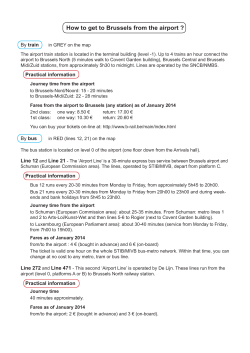


© Copyright 2026