
Technical Report Beaver Dam Gold Project Nova Scotia, Canada.
Technical Report of the Beaver Dam Gold Project, Halifax County, Nova Scotia Prepared for Atlantic Gold Corporation by FSSI Consultants (Aust) Pty. Ltd. Prepared by: Neil Schofield MS Applied Earth Sciences, MAIG, MAusIMM March 2 , 2015 FSS International Consultants (Australia) Pty Ltd Title Page Technical Report of the Beaver Dam Gold Project, Nova Scotia, Mineral Resource Estimate Prepared for Atlantic Gold Corporation by FSSI Consultants (Aust) Pty Ltd Prepared by: Neil Schofield MS Applied Earth Sciences, MAIG, MAusIMM Effective Date: March 2, 2015 Signing Date: March 2, 2015 FSSI Consultants (Aust.) Pty Ltd ABN 69 003 643 801 9 Malton Road, Beecroft NSW 2119 Phone: 61 (0) 404 879 931 Fax: (612) 98753542 Email: [email protected] FSS International Consultants (Australia) Pty Ltd D ate and Signature Page March 2, 2015 Neil Schofield Consulting Geologist FSS International Consultants (Australia) Pty Ltd FSS International Consultants (Australia) Pty Ltd Table of Contents TITLE PAGE I DATE AND SIGNATURE PAGE II TABLE OF CONTENTS II 1 7 SUMMARY 1.1 Property description and geological setting..........................................................7 1.2 Exploration history ...................................................................................................7 1.3 Current Mineral Resource Estimates ......................................................................8 1.4 Conclusions ..............................................................................................................10 1.5 Recommendations ...................................................................................................11 2 INTRODUCTION 12 3 RELIANCE ON OTHER EXPERTS 14 4 PROPERTY DESCRIPTION AND LOCATION 15 4.1 Property Location ....................................................................................................15 4.2 Nature of the Mineral Tenure................................................................................15 4.3 Tenure Conditions ..................................................................................................17 4.4 Environmental and Other Liabilities ....................................................................18 4.5 Impact of Previous Mining Activities ..................................................................18 4.6 Proximity of Mineralized Zone to Cameron Flowage .......................................19 4.7 Required Permits .....................................................................................................19 4.8 Factors and Risks for Ongoing Mineral Exploration .........................................19 5 ACCESSIBILITY, CLIMATE, LOCAL RESOURCES, INFRASTRUCTURE, AND PHYSIOGRAPHY 20 5.1 Topography, elevation and vegetation ................................................................20 5.2 Accessibility .............................................................................................................20 5.3 Climate and operating season ...............................................................................20 5.4 Local resources and Infrastructure .......................................................................21 6 HISTORY 22 6.1 Prior Ownership of the Property ..........................................................................22 6.2 Results of Exploration and Development by Previous Owners .......................23 6.3 Previous Resource Estimates .................................................................................26 6.4 Production ................................................................................................................26 7 GEOLOGICAL SETTING FSS International Consultants (Australia) Pty Ltd 27 Contents iii 7.1 Regional Geological Setting ...................................................................................27 7.2 Local Geology ..........................................................................................................28 7.3 Property Geology ....................................................................................................29 7.4 Mineralization..........................................................................................................30 7.4.1 Main Zone Geometry, Grade Distribution and Geological Controls..31 7.4.2 Type and Character of Beaver Dam Mineralisation ..............................31 8 DEPOSIT TYPES 9 EXPLORATION 33 34 9.1 Procedures, Parameters and Results of Investigations ......................................34 9.2 Exploration management .......................................................................................34 10 DRILLING 36 10.1 General......................................................................................................................36 10.2 Resource Area Diamond Drilling Campaigns ....................................................36 10.3 Resource Area Diamond Drill Hole Distribution ...............................................38 10.4 Drilling beyond the Beaver Dam Gold deposit ..................................................40 10.5 List of Beaver Dam Drill holes ..............................................................................41 11 SAMPLE PREPARATION, ANALYSIS AND SECURITY 46 11.1 Mercator Drilling Program 2005-07 ......................................................................46 11.1.1 Introduction ................................................................................................46 11.1.2 Mercator Blanks – Sample Preparation ...................................................46 11.1.3 Mercator Blanks – Discussion and Results .............................................46 11.1.4 ALS Analytical Blanks – Sample Protocol ..............................................47 11.1.5 ALS Analytical Blanks – Results and Discussion ..................................48 11.1.6 ALS Standard Reference Materials – Sample Protocol .........................49 11.1.7 ALS Standard Reference Materials – Results and Discussion .............49 11.1.8 ALS Pulp Duplicates - Introduction ........................................................51 11.1.9 ALS Pulp Duplicates – Sample preparation ...........................................52 11.1.10 ALS Pulp Duplicates – Results and Discussion .....................................52 11.2 Acadian Mining Drilling Program 2009...............................................................53 11.2.1 Introduction ................................................................................................53 11.2.2 Acadian Blanks – Sampling Protocol.......................................................53 11.2.3 Acadian Blanks – Results and Discussion ..............................................53 11.2.4 Acadian Standard Reference Material – Sample Protocol ....................53 11.2.5 Acadian Standard Reference Material – Results and Discussion ........54 11.2.6 ALS Analytical Blanks – Sample Protocol ..............................................55 11.2.7 ALS Analytical Blanks – Results and Discussion ..................................55 11.2.8 ALS Standard Reference Materials – Sample Protocol .........................55 11.2.9 ALS Standard Reference Materials – Results and Discussion .............55 11.2.10 ALS Pulp Duplicates – Sample Protocol .................................................55 11.2.11 ALS Pulp Duplicates – Results and Discussion .....................................55 FSS International Consultants (Australia) Pty Ltd Contents iv 11.3 Atlantic Drilling Program 2014-15 ........................................................................57 11.3.1 Introduction ................................................................................................57 11.3.2 Atlantic Gold Blanks – Sampling Protocol .............................................57 11.3.3 Atlantic Gold Blanks – Results and Discussion .....................................57 11.3.4 Atlantic Gold Standard Reference Materials – Results and Discussion57 11.3.5 Atlantic Gold Fine Fraction Duplicates – Results and Discussion ......58 11.4 Discussion ................................................................................................................59 11.5 Sample security .......................................................................................................60 11.5.1 Mercator Geological Services....................................................................60 11.5.2 Acadian Mining Corporation ...................................................................61 11.5.3 Atlantic Gold Corporation ........................................................................61 12 DATA VERIFICATION 62 13 MINERAL PROCESSING AND METALLURGICAL TESTING 63 13.1 Introduction .............................................................................................................63 13.2 Metallurgical Test Work .........................................................................................63 13.3 Beaver Dam Process Performance Predictions ...................................................65 14 MINERAL RESOURCE ESTIMATES 66 14.1 Introduction .............................................................................................................66 14.2 Estimation Method..................................................................................................66 14.3 Resource Data ..........................................................................................................67 14.4 Spatial Continuity Analysis and Modelling ........................................................70 14.5 The Resource Model ...............................................................................................74 14.5.1 Bulk Density ................................................................................................75 14.5.2 Topography and Previous Underground Mining .................................75 14.5.3 The Resource Estimates, Model Plots and Validation...........................75 23 ADJACENT PROPERTIES 84 24 OTHER RELEVANT DATA AND INFORMATION 84 25 INTERPRETATION AND CONCLUSIONS 85 26 RECOMMENDATIONS 87 27 REFERENCES 88 FSS International Consultants (Australia) Pty Ltd Contents v List of Figures Figure 1: Atlantic Gold Corporation Corporate Structure.................................................. 13 Figure 2: Beaver Dam Property Regional Location Map .................................................... 16 Figure 3: Beaver Dam Property, County Location Map ..................................................... 16 Figure 4: Image showing the extent of mine workings and Cameron Flowage. .................. 17 Figure 5: Historic Surface Drill Hole Distribution ............................................................. 24 Figure 6: Regional Geology of Nova Scotia – Meguma Terrane (Sangster and Smith, 2007)28 Figure 7: Local Geology of Beaver Dam Gold Project (Interpretation by J. Utley) ............. 29 Figure 8: Geometry of the Main Zone gold mineralization relative to stratigraphy ........... 31 Figure 9: Acadian Mining and Atlantic Gold Corporation drill-hole locations.................. 36 Figure 10: Section and plan view of drill hole composite gold grades ................................. 39 Figure 11: Mercator analytical blanks vs Sample Number ................................................. 47 Figure 12: Mercator analytical blanks vs Previous Sample gold grade............................... 48 Figure 13: Detailed results for ALS Chemex SRM OXD43 ............................................... 50 Figure 14: Detailed results for ALS Chemex SRM OxF41 ................................................. 51 Figure 15: Detailed results for ALS Chemex SRM SP17 ................................................... 51 Figure 16: Minus fraction duplicate vs original, 2005-07 sampling program .................... 52 Figure 17: Minus fraction duplicate precision plot, 2005-07 sampling program ............... 53 Figure 18: Minus fraction duplicate vs original, 2009 drilling program ............................ 56 Figure 19: Minus fraction duplicate precision plot, 2009 drilling program ....................... 56 Figure 20: Results of assaying of five assay standards, 2014-15 program. ......................... 58 Figure 21: Minus fraction duplicate vs original, 2014-15 drilling program ...................... 59 Figure 22: Minus fraction duplicate precision plot, 2014-15 drilling program .................. 59 Figure 23: Cumulative histogram of 2m composite gold grades. ........................................ 67 Figure 24: Composite plan and section of Beaver Dam drill-hole gold grades. ................... 69 Figure 25: Directional indicator sample variograms, 60th percentile, Beaver Dam ............ 71 Figure 26: Directional variogram models, 60th percentile, Beaver Dam ............................. 71 Figure 27: Directional indicator sample variograms, 90th percentile, Beaver Dam ............ 72 Figure 28: Directional variogram models, 90th percentile, Beaver Dam ............................. 72 Figure 29: 3D plot of indicator variogram (60th percentile) model showing directional anisotropy 73 Figure 30: Extent of underground workings at Beaver Dam .............................................. 75 Figure 31: Sections with average panel grade, neighbouring drill-hole grades, panel classification. 80 Figure 32: Sections with average panel grade, neighbouring drill-hole grades, panel classification. 81 Figure 33: EW Section: Accumulated tonnes and accumulated metal, 0.54 gpt cut-off ..... 82 Figure 34: Cumulative histograms of declustered samples and estimated panel grades ..... 83 FSS International Consultants (Australia) Pty Ltd Contents vi List of Tables Table 1: Summary of Historic Drilling Programs – Beaver Dam Property ........................ 25 Table 2: Summary of Bulk Sampling – Beaver Dam Property (after O’Sullivan, 2003) .... 26 Table 3: Summary of Acadian and AGC Diamond Drilling Programs – Beaver Dam Property 37 Table 4: Acadian Diamond Drill Holes outside Resource Area .......................................... 40 Table 5: Acadian Reverse Circulation Drill Holes outside Resource Area .......................... 41 Table 6: Beaver Dam drill holes with sampled intervals ..................................................... 41 Table 7: Protocols for treatment of blanks ........................................................................... 48 Table 8: Statistics of ALS Chemex results of assaying 16 SRM’s ....................................... 49 Table 9: ALS results for Standard OxP50. .......................................................................... 50 Table 10: Assay Results for SRM’s 0xG70 and PM914 ..................................................... 54 Table 11: Assay Results for SRM’s PM403, PM405 and PM410 ...................................... 54 Table 12: Assay Results for SRM’s PM413 and PM427 .................................................... 55 Table 13: Summary of ALS standards inserted during 2009 .............................................. 55 Table 14: Beaver Dam Composites ...................................................................................... 63 Table 15: Beaver Dam Bond Ball Mill Index ....................................................................... 63 Table 16: Beaver Dam Gravity Separation Conditions / Results Overall Acadian Composite64 Table 17: Beaver Dam Gravity Tailing Cyanidation Results.............................................. 65 Table 18: Conditional statistics of 2m composites, Beaver Dam ......................................... 68 Table 19: Indicator variogram model parameters, Beaver Dam .......................................... 73 Table 20: Panel Model Parameters ...................................................................................... 74 Table 21: Variance adjustment ratios for change of support ............................................... 74 Table 22: Global Measured resource estimates, Beaver Dam (base case in bold font) ........ 76 Table 23: Global Indicated resource estimates, Beaver Dam (base case in bold font) ......... 76 Table 24: Global Measured+Indicated resource estimates, Beaver Dam (base case in bold font) 76 Table 25: Global Inferred resource estimates, Beaver Dam (base case in bold font) ........... 77 Table 26: Summary statistics of composite and panel grades .............................................. 83 FSS International Consultants (Australia) Pty Ltd Introduction 1 Summary 1.1 Property description and geological setting The Beaver Dam property, or the (Project), is located in Halifax County, central Nova Scotia, approximately 85 km northeast of the provincial capital of Halifax. The property covers the historical Beaver Dam gold district located on NTS map sheet 11E02/A with central coordinates of 0521319 E/4990700 N (UTM NAD 83 Zone 20). The area is uninhabited with the closest residences situated 5 km away. Gold mineralization at Beaver Dam occurs in the rocks of the Meguma Group. The Meguma Group sedimentary package is divided into two distinct formations: the Goldenville Formation and the younger Halifax Formation, both of which have been subject to greenschist to amphibolite grade regional metamorphism. The majority of the Meguma gold deposits are found within the Goldenville Formation and are typically associated with regional anticlinal folds close to later northwest trending transcurrent faults. Mineralisation at Beaver Dam occurs in the north-dipping southern limb of an overturned anticline with gold hosted both within quartz veins and disseminated through the intervening inter-bedded argillite and greywacke. It is the quartz vein hosted gold mineralization augmented by disseminated style mineralization in or near anticline hinges that forms the basis of a geological model associated with the ongoing exploration and development of the Beaver Dam gold deposit. 1.2 Exploration history Gold was discovered at Beaver Dam in 1868 and there were intermittent attempts from 1871 up until 1949 to develop and mine in the area, initially focused on the Austen Shaft area and later, also on the Mill Shaft area, 1.2km to the west of the Austen Shaft. There was early acknowledgment of significant volumes of low grade material, including the excavation of the small Papke pit approximately 400m west of the Austen Shaft in 1926, however, most of the development focused on a belt of quartz veins in greywacke and slates that was approximately 23m wide where intersected from the Austen Shaft. The next major period of work began in 1975 when MEX Explorations acquired claims in the area and from 1978 until 1988 a number of different companies drilled a combined total of 251 diamond holes for 47,944m as well as undertaking mapping and geophysical and geochemical surveys. Between 1986 and 1989, Seabright explored from underground via a decline that reached a maximum depth of 100m below surface. In that same period, Seabright drilled 34 holes from underground for a total of 2290m and mined 135,000 tonnes of material of which 41,119 tonnes was milled at an average reconciled gold grade of 1.85 gpt. In 1987, Seabright also excavated a small open-pit in the Papke and Austen zones, removing 10,055 tonnes of which 8,822 tonnes was milled for a reconciled gold grade of 2.45 gpt. FSS International Consultants (Australia) Pty Ltd Summary 8 A total of 967 ounces of gold production is recorded for the Beaver Dam gold district between 1889 and 1941. A further 2445 ounces has been recovered from bulk samples taken between 1986 and 1989. In 2002, Tempus Corporation, later Acadian Gold Corporation and now known as Acadian Mining Corporation (Acadian), acquired the Beaver Dam Property. Acadian utilised Mercator Geological Services (Mercator) to manage their exploration activities until 2008 and since then, Acadian has managed all exploration activities within the Property. Acadian initially used Mercator Geological Services to manage exploration activities and one of the first activities undertaken by Mercator was an extensive compilation, review and validation of the historic diamond drilling and associated sampling and assaying during which, records for 238 surface and underground drill holes were examined. Between 2005 and 2009, Mercator and then Acadian managed several diamond drill programs with a total of 153 holes drilled for 22010m. Of those holes, 146 were drilled in the Main Zone and the remainder distributed between the Mill Shaft Zone and the Northeast Zone. At the completion of the drilling, the Main Zone has been drilled by Acadian on a nominal 25m x 25m pattern over a strike length of approximately 800m with mineralisation still open to the west and at depth. Acadian also undertook several other exploration programs within the Project; an aeromagnetic survey at 100m and 50m line spacings, a till survey and a follow-up shallow Reverse Circulation (geochemical) drilling program that led to recognition of a possible offset to the Main Zone mineralisation on the northern side of the Mud Lake Fault. 1.3 Current Mineral Resource Estimates From 2005 until 2009, Acadian Mining Corporation funded the drilling of 153 diamond drill holes to evaluate the mineral resources of Beaver Dam during which some 22010 metres of drilling were completed. Following a positive outcome of their PEA Study in 2014, Atlantic Gold drilled a further 7810 metres in 38 holes to replace the older Seabright drilling which was selective sampled and for which no useful quality control data exists. The current mineral resource estimates are based on only the Mercator-Acadian-Atlantic Gold drilling results. The method used to estimate the mineral resources of Beaver Dam is a standard implementation of multiple indicator kriging with block support correction for the estimation of recoverable resources based on a specified approach to selective mining. The GS3M© software provides a full implementation of this approach. The resource has been classified using the CIM standards for mineral resource classification (CIM, 2014). The estimates have been generated from some 9432 two metre sample composites in one geologic domain. The tables below present the current mineral resource estimates of FSSI Consultants (Aust.) for the Beaver Dam gold deposit for a number of cut-off grades. The base case cut-off grade of 0.5 gpt is shown in bold font. There are no known environmental, permitting, legal, FSS International Consultants (Australia) Pty Ltd Summary 9 title, taxation, socio-economic, marketing and political or other factors that could materially affect the resource estimates. Gold Cut-off Measured Resource Estimates Ounces gpt Million Tonnes Gold gpt 0.3 5.34 1.27 218,200 0.4 4.65 1.41 210,600 0.5 4.07 1.55 202,200 0.6 3.65 1.66 194,800 0.7 3.30 1.77 187,500 0.8 2.97 1.88 179,600 Resources that are not reserves do not have demonstrated economic viability Gold Cut-off Indicated Resource Estimates Ounces gpt Million Tonnes Gold gpt 6.75 1.13 244,200 0.3 5.94 1.23 235,100 0.4 5.20 1.34 224,400 0.5 4.60 1.45 213,900 0.6 4.09 1.55 203,200 0.7 3.62 1.65 191,800 0.8 Resources that are not reserves do not have demonstrated economic viability Gold Cut-off Measured + Indicated Resource Estimates Ounces gpt Million Tonnes Gold gpt 0.3 12.09 1.19 462,421 0.4 10.59 1.31 445,742 0.5 9.27 1.43 426,788 0.6 8.25 1.54 408,642 0.7 7.39 1.65 390,647 0.8 6.59 1.75 371,398 Resources that are not reserves do not have demonstrated economic viability Gold Cut-off Inferred Resource Estimates Ounces gpt Million Tonnes Gold gpt 2.65 1.08 91,800 0.3 2.26 1.20 87,400 0.4 1.84 1.37 81,300 0.5 1.52 1.55 75,600 0.6 1.28 1.72 70,600 0.7 1.08 1.90 65,700 0.8 Resources that are not reserves do not have demonstrated economic viability FSS International Consultants (Australia) Pty Ltd Summary 10 1.4 Conclusions The gold mineralization occurs in rocks of the Meguma Group which at Beaver Dam comprise a near vertically dipping suite of greywackes and argillites. The mineralization style is similar to a number of other gold deposits in the Meguma Group of Nova Scotia including Touquoy and Cochrane Hill. At Beaver Dam, the structures carrying the gold mineralization dip more shallowly than the bedding at around 65 degrees to the north. The diamond drilling undertaken by Mercator in 2005-07, Acadian Mining Corporation in 2009 and Atlantic Gold in 2014-15 together with documented quality control procedures and QA/QC data provide a sound basis for mineral resource estimation and classification at Beaver Dam. The assay results of standards and blanks inserted into the sample batches do not indicate any significant bias in assaying across a wide range of gold grades. The results of minus fraction sample duplicates based on entire half core pulverizing and screened fire assaying indicate a high level of sampling precision is being achieved. The current resource estimates of Beaver Dam are based on the analysis of the gold grades of some 9432, two metre sample composites generated from 192 drill-holes into the Main Zone of the deposit. The composite grades show large statistical variation similar to those of many other gold deposits with high coefficients of variation, in the case of Beaver Dam around 9. The current drill hole sampling density is at a minimum of around 25 metres along strike and down dip within the mineralization. A single mineralized domain of samples has been used to represent the mineralization. Spatial continuity (variogram) analysis of the composite grades is consistent with the geologic interpretation of the mineralization as a relatively thin body of mineralization extending east-west along strike and dipping steeply to the north. Continuities are strongest along strike and to a much lesser extent, down dip. The recoverable resources of Beaver Dam potentially available to open pit mining have been estimated using the method of multiple indicator kriging with block support correction. The indicator kriging used fourteen indicator thresholds. It is assumed that ore selection will take place on five metre flitches with a minimum mining width of five metres. Grade control sampling on a five metre by five metre pattern for ore selection is also assumed. The resource estimates have been classified as Measured, Indicated and Inferred to reflect the number and spatial pattern of drill-hole composites informing the estimation of each panel in the model. The pattern of spatial continuity shown in the variograms and general experience with gold deposits with the characteristics of Beaver Dam suggest that a drill hole spacing of around 20 to 25 metres is appropriate to establish Measured resource estimates in this deposit. FSS International Consultants (Australia) Pty Ltd Summary 11 For the 0.5 gpt cut-off, the additional drilling undertaken by Atlantic Gold has increased the Measured resource tonnage by 1.2 million tonnes and the Indicated resource tonnage by 2.3 million tonnes while the Inferred resource tonnage has decreased by 0.8 million tonnes. For the Measured and Indicated resource estimates, the Atlantic drilling has brought about an increase of 49 percent in contained ounces of gold. 1.5 Recommendations 1. No further resource drilling is recommended for the Beaver Dam resource at the present time. 2. The Beaver Dam resource model should be incorporated as part of the feasibility study being undertaken to establish the viability of mining the Beaver Dam deposits. FSS International Consultants (Australia) Pty Ltd Introdcution 12 2 Introduction This Technical Report has been prepared for Atlantic Gold Corporation to describe the preparation of Mineral Resource estimates for the Beaver Dam Gold Project, Halifax County, Nova Scotia, Canada. Prior to its name change to Atlantic Gold Corporation, the Company's predecessor entity, Spur Ventures Inc. ("Spur"), had been involved in the phosphate fertilizer business in China. Following the sale of its interests in the phosphate business in 2012, Spur began focusing on the acquisition of advanced mineral projects in mining-friendly jurisdictions. In August 2014, Spur changed its name to Atlantic Gold Corporation and in August and September of 2014, Spur completed the following two transactions with two corporate entities which held, among others, the Touquoy, Beaver Dam and Cochrane Hill Projects: All share merger with Atlantic Gold NL ("Atlantic Gold NL" or "Atlantic Gold") which held the Touquoy Project and Cochrane Hill Project; and Acquisition of Acadian Mining Corporation ("Acadian" or "Acadian Mining"), which held the Beaver Dam Project The merger with Atlantic Gold NL was implemented in August, 2014 via a scheme of arrangement under Part 5.1 of the Australian Corporations Act 2001 under which Atlantic Gold Corporation acquired all the fully paid and partly paid ordinary shares on issue in Atlantic Gold NL. The acquisition of Acadian was completed in September 2014. The Company acquired 100% of Acadian from LionGold Mining Canada Inc., a subsidiary of LionGold Corp Ltd, a diversified mining company listed on the Singapore Stock Exchange, in exchange for the issuance of cash and AGB shares. Further information in respect of the two above noted transactions is available on the Company's website (www.atlanticgoldcorporation.com) and SEDAR (www.sedar.com). A summary corporate structure of the Company as at the date of this report is also set out in the Figure below: FSS International Consultants (Australia) Pty Ltd Introdcution 13 Figure 1: Atlantic Gold Corporation Corporate Structure The work of resource estimation reported herein was undertaken by Neil Schofield, MAIG who is full-time employee of FSSI Consultants (Aust.) Pty Ltd and has more than five years of experience in the field of Mineral Exploration and more than 20 years of experience in mineral resource estimation in a wide range of base and precious metal deposits. He is a Qualified Person in terms of NI43-101 standards for Exploration Results and of Mineral Resource estimation in general. The Mineral Resource estimates are based on a drill-hole database prepared and supplied by Acadian Mining Corporation. Neil Schofield visited the project in July 2014 in company with John Morgan of Atlantic Gold Corporation and Rick Horne formerly of Acadian Mining Corporation. Drill core of the mineralization was reviewed, previous resource estimates were reviewed and the details of further drilling for resource evaluation were discussed. FSS International Consultants (Australia) Pty Ltd Reliance on Experts 14 3 Reliance on Other Experts With respect to legal title to the Beaver Dam mineral claims, which comprise the Beaver Dam property and is referred to in section 4, Property Description and Location, Neil Schofield has relied on the opinion of Mathew Newell of Stewart McKelvey Lawyers Avocats. In letters of 7 October 2014 Mr. Newell warrants that Acadian holds the mineral claims comprising the Property. As described in section 2 of this report Atlantic Gold Corporation acquired Acadian in a transaction that was completed in September of 2014. In addition the claims are shown as being in good standing and held by Annapolis Properties Corp. (a wholly-owned subsidiary of Acadian Mining Corp.) on the Nova Scotia’s Registry of Claims (NovaROC) website (https://novaroc.novascotia.ca/novaroc/page/home.jsf). FSS International Consultants (Australia) Pty Ltd Property Description and Location 15 4 Property Description and Location 4.1 Property Location The Beaver Dam property is located in Halifax County, central Nova Scotia, approximately 85 km northeast of the provincial capital of Halifax ( Figure 2) The property covers the historical Beaver Dam gold district located on NTS map sheet 11E02/A with central coordinates of 0521319 E/4990700 N (UTM NAD 83 Zone 20). The area is uninhabited with the closest residences situated 5 km away. 4.2 Nature of the Mineral Tenure The property is held under a single mineral exploration licence EL50421, currently held by Annapolis Properties Corporation, a wholly owned subsidiary of Acadian Mining which in turn is a wholly owned subsidiary of Atlantic Gold. Licence 50421 is comprised of 76 contiguous claims which cover an area of approximately 569 hectares. Licence 50421 is an amalgamation of EL05920 and EL06175 which was reissued as EL50421 in August 2014. Licence 05920 represented the amalgamation of three pre-existing exploration licences; 00047, 04790 and 04516 which were acquired in 2002 by Tempus Corporation; Tempus subsequently became Acadian Gold and later Acadian Mining. The licences were regrouped in 2003 as EL05920 and reissued by the Nova Scotia Department of Natural Resources (NSDNR) in 2005. Acadian owns 100% interest in licence 50421 however portions of the licence are subject to differing agreements made prior to its acquisition by Tempus. Asset name/ Country Beaver Dam, Canada, EL50421 Issuer’s interest (%) 100% Type of minerDevelopment Licence expiry Licence Area al, oil or gas Status date deposit 569.4 Exploration May 13, 2015 Gold hectares Previous licence 00047 was acquired from Westminer Canada and is subject to a Variable Return Net Smelter Royalty (NSR) payable to Acadia Mineral Ventures Limited. Royalty amounts are based on the average grade of mined material and range from 0.6% at average grade of 4.7 gpt Au or less, up to 3% at an average grade of 10.9 gpt Au or more. Some C$300,000 is available as credit against future royalties at a maximum of 50% per royalty payment, payable twice a year. Tempus acquired licence 04516 from Henry Schenkels. This licence is subject to a Sliding Scale Net Smelter Royalty based on the price of gold. Royalties range from 0% at a gold price of US$265.01 ozs Au or less, up to 2% at gold prices of US$320 ozs Au or greater. Additional royalties exist for any other commodities produced on this licence including silver, copper, lead and zinc, although future recoveries of these metals is highly unlikely. FSS International Consultants (Australia) Pty Ltd Property Description and Location Figure 2: Beaver Dam Property Regional Location Map Figure 3: Beaver Dam Property, County Location Map FSS International Consultants (Australia) Pty Ltd 16 Property Description and Location Figure 4: Image showing the extent of mine workings and Cameron Flowage. 4.3 Tenure Conditions Mineral exploration licences are issued by the Nova Scotia Department of Natural Resources (NSDNR) under the Mineral Resources Act of 1990. Staking of claims is based on an NTS based map staking system and the claims have not been legally surveyed. Licence 50421 shown in Figure 3 represents the two successive amalgamations of pre-existing licences, three of which were combined into a single licence in 2002 and then combined with a fourth licence in 2014. When multiple licences are combined, the staking date for the oldest licence is used as the official ‘staking date’ for the newly formed licence. In the case of 50421, the staking date is May 13, 1975. Yearly assessment expenditures and renewal fees are required in order to maintain the claims in good standing. Required yearly expenditures increase over the lifespan of the licence to a maximum of C$800 per claim after 25 years. Since licence 050421 is in its 40th year of issue, yearly work commitments are C$60,800 per year. Expenditures in excess of this amount can be carried forward and used to renew a licence in subsequent years however; assessment credits submitted for any particular year have a maximum lifespan of 10 years. Acadian has confirmed via the online Nova Scotia Registry of Claims (NOVAROC) that as of April 7th, 2015 licence 50421 is in good standing and is issued in the name of Annapolis Properties Corp. As of the most recent anniversary date (May 13, 2014) the registry indicates that sufficient work credits exist to renew this licence for the next five years. FSS International Consultants (Australia) Pty Ltd 17 Property Description and Location 4.4 Environmental and Other Liabilities The property is located within an area of active forestry and historic mining activity. No restrictions with regards to mineral exploration and mining apply to the property, however, as with any area, proper environmental consideration and historic cultural screening is required. Several environmental considerations were outlined by Jacques, Whitford and Associates Limited (Jacques, Whitford and P. Lane, 1986) prior to underground exploration carried out by Seabright Resources in the late 1980s. Many of the same issues would need to be addressed should a mine be constructed on the property in the future in order to prevent negative environmental impact. The main issues outlined were: Mine water control Erosion and drainage control Integrity of waste rock storage areas Refuse and garbage disposal Sewage disposal Storage and handling of hazardous fluids Impacts on the freshwater ecosystem Impacts on wildlife The report suggests that all of the outlined issues could be controlled by careful engineering practices during mine development and planning. Also, the report identified a low-lying area west of Cameron Flowage that provides an excellent area for water containment and primary sedimentation. Seabright followed the recommendations outlined in the Environmental Assessment and retained Jacques Whitford to carry out ongoing environmental sampling and monitoring. Furthermore, Seabright utilized the suggested water containment area as a settling pond by constructing a dam along its eastern margin in order to control outflow. The pond still functions to settle sediment before runoff enters Cameron Flowage and could be utilized during future exploration activities. 4.5 Impact of Previous Mining Activities During the underground exploration programme, ore was stored at surface for a short time until it was trucked to the Gay’s River mine site for processing. All of the tailings associated with processing of rock from Beaver Dam were deposited at Gay’s River. Because the processing and tailings deposition occurred off-site, there was little chance for the local environment to be contaminated. In 1989, underground exploration at Beaver Dam was ceased and the site was reclaimed, which included backfilling the underground portal and the open cut, backfilling of ore and waste storage pads, drainage ditches and settling ponds, and removal of all of the buildings on the property ( Figure 4). Today there is little evidence that any mining activities occurred on the property, which is now well vegetated with a variety of softwood and hardwood. FSS International Consultants (Australia) Pty Ltd 18 Property Description and Location 4.6 Proximity of Mineralized Zone to Cameron Flowage Cameron Flowage transects the eastern portion of the property from northwest to southeast ( Figure 4). Although this waterway does not impede exploration, consideration will need to be given prior to construction of an open pit. Because of its size, diverting the river would likely be too costly to undertake; this could be avoided by limiting the maximum depth of the eastern portion of the open pit such that its footprint does not encroach on the waterway. At this point however, further studies including a topographic (LiDAR) survey are required to determine the potential impact and potential solutions. 4.7 Required Permits No permits or approvals are required to conduct non-intrusive exploration and drilling activities on the property. Drilling notification is required with NSDNR prior to commencement of any drilling activity and details of the drilling must be provided after drilling is completed. Permits are required prior to conducting trenching, bulk sampling or mining on the property. Mine development would require several permits, including, but not limited to, an Environmental Assessment, Industrial Approval and a Mine Lease. 4.8 Factors and Risks for Ongoing Mineral Exploration Obtaining access to conduct exploration on the property from Northern Pulp has not been an issue in the past; however no agreements concerning future exploration and/or mining have been established. Prior to any mine development, many of the environmental liabilities outlined above will require special consideration, however all issues are considered manageable. FSS International Consultants (Australia) Pty Ltd 19 Accessibility, Climate etc 5 Accessibility, Climate, Local Resources, Infrastructure, and Physiography 5.1 Topography, elevation and vegetation Beaver Dam is an area of low topographic relief with most of the area being around 140m elevation with scattered drumlins reaching 160m elevation. Drainage is to the south-east along a number of poorly drained streams and shallow lakes. There are a number of boggy areas within the property. Vegetation consists of spruce, fir and some hardwood. Logging has been widely carried out more recently including clear cutting in the immediate area of the deposit. 5.2 Accessibility The Beaver Dam project is easily accessed by the Beaver Dam Mines Road, an unpaved secondary road branching north-eastward from provincial highway #224. Beaver Dam mines road is a well maintained and frequently travelled road used by forestry companies actively operating in the area. During the winter snow removal on unpaved roads is infrequent and heavy snowfall may result in the property becoming inaccessible by vehicle for days at a time unless they are ploughed. Acadian does not hold any of the surface titles for the land on which the Beaver Dam property occurs. The primary landholder in the area is Northern Pulp Nova Scotia Corporation, who owns several parcels of land comprising a large portion of the Beaver Dam property. Although no current land access agreement exists with Northern Pulp, in the past they have provided access for Acadian to carry out exploration. Furthermore, Acadian is currently in discussions with Northern Pulp to establish long term access on the property which would include first right of refusal for purchase or a purchase agreement. The remaining parcels of land which make up the Beaver Dam property are owned by the Crown. To date, Acadian has successfully gained access to crown lands to conduct exploration at Beaver Dam and several other properties. The province of Nova Scotia is generally supportive of the mining industry and there is no reason to think that an access agreement for mining cannot be arranged with the Crown if economic deposits are defined on crown land. 5.3 Climate and operating season Eastern Nova Scotia is characterised by northern temperate zone climatic conditions moderated by proximity to the Atlantic Ocean. Seasonal variations occur, with winter conditions of freezing and/or substantial snowfall expected from late November through late March. Spring and fall seasons are cool, with frequent periods of rain. Summer conditions can be expected to prevail from late June through early September with modest rainfall and daily mean temperatures in the 15°C to 20°C range. Maximum daily summer temperatures to 30°C occur, with winter minimums in the -25°C to -30°C range. Mineral exploration programmes can efficiently be undertaken during the period of May through late November, while winter programmes can be accommodated with appropriate allowance for weather delays. FSS International Consultants (Australia) Pty Ltd Accessibility, Climate etc 5.4 Local resources and Infrastructure Acadian Mining retained the Cultural Resources Management Group Limited (CRMG) to conduct a preliminary archaeological screening and reconnaissance programme on the Beaver Dam property in order to identify any potential cultural resources. Two areas were identified as having high potential for pre- European contact (aboriginal) cultural significance which consisted of flat, well drained areas along the margins of Cameron Flowage which may have been visited by early travellers of the waterway (Stewart and Beanlands, 2009). The study also outlined a number of sites which contained features of significance such as remains of buildings and other structures. These structures were likely related to historical mining activities on the property but warrant further investigation. CRMG made several recommendations related to the property including a more thorough investigation into the area once mine development plans are finalised. Also, areas identified as having potential cultural significance should be avoided during mine development. If these areas cannot be avoided, a focused investigation should be conducted prior to their alteration (Stewart and Beanlands, 2009). In 2009, Conestoga-Rovers & Associates on behalf of Acadian retained the Environmental Services division of the Confederacy of Mainland Mi’kmaq to conduct an ecological knowledge study for the Beaver Dam area (CMM Environmental Services, 2009). The report acknowledged that Mi’kmaq lived in areas south of Beaver Dam (e.g. Sheet harbour, Spry bay and Ship harbour) and would have likely used the local waterways during hunting and fishing expeditions but no specific evidence of Mi’kmaq landing on the Beaver Dam property were mentioned. The report also outlined potential impacts that the Beaver Dam project may impose on Mi’kmaq land and resource use. The two issues outlined were: the destruction of any potential native archaeological sites on the property and the loss of several plant species within the area. If any Mi’kmaq archaeological deposits are encountered during construction or operation of the project, work should be halted and the appropriate authorities (Nova Scotia Museum and The Confederacy of Mainland Mi’kmaq) should be notified. The significant plant species which were identified within the proposed Beaver Dam area are also found in the surrounding area so the impact of the project is limited to only the specimens within the project area. FSS International Consultants (Australia) Pty Ltd 21 History 6 History 6.1 Prior Ownership of the Property Gold was discovered at Beaver Dam in 1868. The first production is recorded in 1871. An English company, under the direction of D.J. Thomas examined the property a short time later but there was very little work until 1886 when William Yeadon constructed a 4-stamp test mill and did some exploratory mining. In 1891, Yeadon sold his property to the Beaver Dam Mining Company who erected a 10-stamp mill. In 1895, Beaver Dam Mining leased the property to G.M. Christie and W.M. Tupper and the following year, the property was transferred to J.H. Austen who constructed a 10-stamp mill and sank the Austen Shaft. W.H. Redding set up a 5-stamp battery and sank a shallow shaft on a series of quartz veins 1.2km to the west of the Austen Shaft in 1904 and activities in that area continued in 1911 when the Gladwin Mining Company deepened Redding’s Shaft. In 1921 and 1922, the Gladwin Mining Company tested the area around the Austen Shaft. W. Papke excavated a small pit 400m west of the Austen Shaft in 1926 and together with a Mr Goudry, dewatered the Austen Shaft and extended the workings in 1928. At that same time, the Redding’ Shaft, by then known as the Mill Shaft was extended and bulk sample testing undertaken. In 1935, the Austen Shaft was worked by B.F. Belmore and a Mr Inglehart and in 1936, the area encompassing the Austen Shaft was held by the Beaver Dam Gold Mining Syndicate who set up a test mill and processed a bulk sample from workings off the Austen Shaft. The shaft was allowed to flood and then dewatered again in 1937 and further development undertaken. The Beaver Dam Gold Mining Syndicate dewatered the Mill Shaft in 1939 and completed further underground development and mining until a fire destroyed the surface plant and equipment. No further work is recorded until 1954 through to 1957 when Lawrence Construction Company Ltd completed some trenching within 200m of the Austen Shaft. In 1975, M.E.X. Explorations acquired claims in the area and in 1978, reached an agreement with Agassiz Resources and later with Comiesa Corporation, a company which was largely controlled by Agassiz, for those companies to undertake exploration. Acadia Mineral Ventures funded further work by M.E.X Explorations in 1983 that included mapping, geophysical and geochemical surveys and diamond drilling. In 1985, Seabright Resources Inc. optioned claims in the Austen Shaft area from Acadia Mineral Ventures and between 1985 and 1987 conducted a number of exploration programs. FSS International Consultants (Australia) Pty Ltd History 23 In the same year, Coxheath Gold Holdings acquired claims to the immediate west and north of the Seabright claims, including the Mill Shaft area. Coxheath completed some exploration in its own right before optioning the property to Seabright. Seabright held the property up until February 1988 when Westminer Canada Ltd took over Seabright. The takeover resulted in a legal dispute and after losing the case in 1993, Westminer withdrew from its Canadian properties. The Beaver Dam property was acquired by Tempus Corporation in 2002. Tempus subsequently changed its name to Acadian Gold Corporation, and changed it again in 2007 to Acadian Mining Corporation. Acadian is current holder of the property. As shown in Figure 1, in 2014, Atlantic Gold NL merged with Spur Ventures Inc and became Atlantic Gold Corporation. In that same year, Atlantic Gold Corporation acquired Acadian Mining and as a consequence, now controls all of the claims over the historic gold district. 6.2 Results of Exploration and Development by Previous Owners Gold was discovered at Beaver Dam in 1868. A 15-stamp battery was erected in 1871 and there were intermittent attempts up until 1949 to develop and mine in the area, initially focused on the Austen Shaft area and later, also on the Mill Shaft area, 1.2km to the west of the Austen Shaft. There was early acknowledgment of significant volumes of low grade material, including the excavation of the small Papke pit approximately 400m west of the Austen Shaft in 1926, however, most of the development focused on a belt of quartz veins in greywacke and slates that was approximately 23m wide where intersected from the Austen Shaft. From that period, until 1975, the only work recorded for the area is a program of trenching and sampling undertaken between 1954 and 1957 and dewatering and channel sampling in the Austen Shaft in 1965. In 1975, MEX Explorations acquired claims in the area and in 1978, reached an agreement with Agassiz Resources in which the latter drilled nine diamond holes for a total of 644m and excavated several trenches to expose mineralised zones between the Austen Shaft and the Papke Pit. The drilling was continued by Comiesa Corporation, a company which was largely controlled by Agassiz, extending drill coverage to the Mill Shaft area with a further nine holes for 1003m. In the same year, MEX drilled two diamond holes in the vicinity of the Mill Shaft for 213m and stripped a portion of the Papke Belt in order to take a bulk sample. Both Agassiz and Comiesa decided that there was insufficient continuity in the mineralised veins to continue with the project. Acadia Mineral Ventures funded further work by M.E.X Explorations in 1983 that included mapping, geophysical and geochemical surveys and diamond drilling. Eleven holes were drilled for a total of 758m. In 1985, Seabright Resources Inc optioned claims in the Austen Shaft area from Acadia Mineral Ventures and in that same year, optioned claims held by Coxheath Gold Holdings to the immediate west and north of the Seabright claims, including the Mill Shaft area. FSS International Consultants (Australia) Pty Ltd History 24 Coxheath completed a VLF survey and a geochemical sampling program before optioning the property to Seabright. Between 1985 and 1987 Seabright, with supervision mostly provided by MPH Consulting Ltd, conducted a number of exploration programs comprising geological mapping and prospecting, soil geochemical surveys, magnetic, VLF-EM, horizontal loop EM and IP and Resistivity geophysical surveys together with drilling of 304 shallow Reverse Circulation (RC) holes for a total of 1219m and 186 diamond holes for a total of 43,027m. The programs allowed Seabright to delineate an auriferous zone of between 20m and 30m width over 700m in strike length and to as much as 600m depth. Figure 5 shows the distribution of historic holes drilled from surface. Figure 5: Historic Surface Drill Hole Distribution The diamond drilling comprised four diamond drill programs from surface and another from underground, and led to four separate resource and reserve estimates and to a mine feasibility study by Kilborn Engineering in 1987. These estimates are available as open file assessment reports from the Nova Scotia Department of Natural Resources. Between 1986 and 1988, Seabright explored from underground via a decline that reached a maximum depth of 100m below surface. In that period, 135,000 tonnes of material was mined of which 41,119 tonnes was milled at an average reconciled gold grade of 1.85 gpt. As part of that exploration, Seabright completed several diamond drill programs from under- FSS International Consultants (Australia) Pty Ltd History 25 ground, drilling 34 holes for a total of 2290m between 1987 and 1988. In 1987, Seabright also excavated a small open-pit in the Papke and Austen zones, removing 10,055 tonnes of which 8,822 tonnes was milled at the Gays River plant for a reconciled gold grade of 2.45 gpt. Table 2 summarizes the history of bulk sampling at the Beaver Dam property. In February of 1988, Westminer Canada Ltd took over Seabright. Westminer undertook resource and reserve estimates for Beaver Dam but obtained quite different results to those produced by MPH on Seabright’s behalf which led to Westminer filing an unsuccessful civil action against the directors of Seabright. Acadian Gold Corporation (now Acadian Mining Corporation) as Tempus Corporation acquired the project in 2002 and completed several diamond drill programs from surface between 2004 and 2007. These programs are discussed in Item 10 - Drilling. Consultants, Mercator providing supervision during most of that time and calculated two separate NI 43-101 compliant resource estimates as progressively more diamond drill data became available. Acadian have completed an aeromagnetic survey, a till sample survey and follow-up shallow RC drilling over the property which is described in Item 9 – Exploration. Table 1 summarizes the historic drilling programs on the Beaver Dam property. Table 1: Summary of Historic Drilling Programs – Beaver Dam Property Year 1978 1980 1980 1983 1985 1986 1986 1987 1987 1988 TOTALS Hole IDs BDS-1 to 2, BD-3 to 9 BD-80-001 to 009 BD80-010 to 011 BD-83-001 to 011 BD85-001 to 092* BD86-001 to 068* CX86-001 to 023A BD87-001, BD87-1012.5B, etc BD-110-01 to 05, BD-R1 to BD-R16 BD-88-1U to BD-88-15U No. of Holes 9 9 2 11 74 66 26 20 644 1,003 213 758 11,931 23,853 4,156 3,087 Surface Surface Surface Surface Surface Surface Surface Surface 20 1,501 Underground Seabright 14 251 789 47,944 Underground Seabright Metres Drilled From: FSS International Consultants (Australia) Pty Ltd Company Agassiz Comiesa Corp MEX Explorations MEX Explorations Seabright Seabright Coxheath Seabright History 26 Table 2: Summary of Bulk Sampling – Beaver Dam Property (after O’Sullivan, 2003) Test No. Date 1,828 Contained Gold (g) 2,236 1.3 5,795 - - Austen Open Pit 2.5 8,732 - - 1100, 1080, 1065, 1050, 1040 1.4 2,634 - - 1.9 17,162 25,399 1.5 1.1 15,738 26,754 1.7 1.2 2,795 4,695 1.7 1.48 37,522 59,084 1.6 8.0 1.5 732 2,865 8,151 6,075 11.1 2.1 1.6 41,119 73,309 1.8 Location 1 Dec-86 1100 2 Nov - Dec 1987 1100, 1090, 1080, 1065, 1050, 1040, 1025 3 3a Dec 1987 Jan 1988 Jan - Feb 1988 Subtotal 2,3,3a 4 May - June 1988 5 Aug - Sept 1988 Subtotal 1-5 6 7 Subtotal 1-7 Mill Clean up Total Oct-88 Mar-89 1100, 1065, 1050, 1040, 1025, Austen Open Pit 1100, 1065, 1050, 1040 1100, 1080 1100, 1065, 1040 Rod Mill Discharge Grade (gpt Au) 1.2 Tonnes Milled Grade Milled (gpt Au) 1.2 2,733 41,119 76,043 1.8 6.3 Previous Resource Estimates Resource estimates prepared for Seabright and for Westminer are available as open file assessment reports from the Nova Scotia Department of Natural Resources. Mercator estimated resources at Beaver Dam for Acadian Gold Corp in 2004 and with more drilling data available, in 2007. The resource estimates were defined for two scenarios, one with uncut gold grades and the other with gold grades cut to 10 gpt. Neil Schofield has prepared a NI 43-101 compliant Mineral Resource estimate for Beaver Dam in September 2014. 6.4 Production A total of 967 ounces of gold production is recorded for the Beaver Dam gold district between 1889 and 1941. A further 2445 ounces has been recovered from bulk samples taken between 1986 and 1989. FSS International Consultants (Australia) Pty Ltd Geological Setting 7 Geological Setting 7.1 Regional Geological Setting Nova Scotia can be divided into two distinct metallogenic terranes; the Avalon Terrane to the north and the Meguma Terrane to the south; see Figure 6 after Sangster and Smith, 2007. These two terranes developed independently until they were juxtaposed along the Cobequid-Chedabucto Fault Zone (CCFZ) during the mid-Devonian Acadian Orogeny (ca. 410-380 Ma). A series of shallow basins developed on both sides of the CCFZ following collision of the two terranes with deposition of fluvial and lacustrine rocks of the Early Carboniferous Horton Group, evaporitic, calcareous and siliciclastic rocks of the Early Carboniferous Windsor Group and Late Carboniferous coal measures. These sediments have in turn been overlain by Early Mesozoic rift sediments and by Early Cretaceous deposits of kaolinitic clay and silica sand (Donohoe, 1996). In Nova Scotia, the rocks of the Avalon Terrane record a complex geological and metallogenic Precambrian and early Palaeozoic history. They represent multiple successions of sedimentation and volcanism, together with felsic to mafic igneous intrusion along what was the continental margin of North America. A number of metalliferous deposits have been recognised in the Avalon Terrane, mostly within Precambrian rocks, including carbonate hosted zinc skarn deposits, stratabound massive sulphide deposits, quartz-vein hosted high-grade gold mineralization in gneiss and diorite, VMS Cu-Pb-Zn-Au in volcanic rocks and Cu-Mo-Au porphyry style mineralization (Donohoe, 1996). The oldest known rocks of the Meguma Terrane are the greywackes and argillites of the Cambrian to Ordovician aged Meguma Group. These rocks were deposited as deep marine turbidites near the continental margin of what is now northern Africa and are uncomfortably overlain by a sequence of Late Ordovician to Early Devonian marine sedimentary and volcaniclastic rocks together with bimodal volcanic rocks. The Meguma Group is divided into two stratigraphic units, the basal greywacke dominated Goldenville Formation and the overlying, finer grained, argillite dominated Halifax Formation. The basal contact of the Goldenville Formation is not known but the Goldenville Formation is at least 5600m thick while the overlying Halifax Formation averages approximately 4400m. These sediments were uplifted and deformed into a series of tightly folded subparallel northeast trending anticlines and synclines during the Acadian Orogeny. The Meguma Group rocks are metamorphosed to greenschist to amphibolite (staurolite) facies and were intruded by granites and minor mafic intrusions by ca. 370 Ma (Smith and Kontak, 1996) The Meguma Group, and predominantly the Goldenville Formation, has hosted most of the gold mineralization exploited historically (from 1860 onward) in Nova Scotia with approximately 1.2 million ozs produced (Bierlein and Smith, 2003). FSS International Consultants (Australia) Pty Ltd Geological Setting 28 Figure 6: Regional Geology of Nova Scotia – Meguma Terrane (Sangster and Smith, 2007) 7.2 Local Geology The geology in eastern Nova Scotia, including the Beaver Dam Property, is dominated by greywackes and argillites of the Cambrio-Ordovician Meguma Group, together with granite intrusives of Devonian age. The different stratigraphic members of the Goldenville and Halifax Formations are exposed by a series of northeast trending tightly folded anticlines and synclines. According to the subdivision proposed by Horne and Pelley (2006), the Moose River Member is the lowermost unit in the Goldenville formation in eastern Nova Scotia and is overlain by the Tangier Member and then by the Taylors Head Member which in turn is overlain by the basal unit of the Halifax Formation. The Goldenville Formation is characterised by a decreasing proportion of finer grained material in successively younger units such that the Moose River and Tangier Members include a significant black claystone and grey or green grey siltstone component while the Taylors Head Member contains only very minor siltstone and virtually no claystone. The Beaver Dam Property lies within the argillite-dominated Moose River Member of the Goldenville Formation which also hosts the Touquoy deposit 19 km to the southwest and the Fifteen Mile Stream gold deposit 17km to the northeast. The Beaver Dam deposit is hosted in the southern limb of a north-dipping overturned. The Moose River Member is at its widest in FSS International Consultants (Australia) Pty Ltd Geological Setting 29 the vicinity of the Beaver Dam deposit with three sub-parallel anticlines evident and the Beaver Dam deposit associated with the central anticline. The deposit is hosted in the southern limb of that anticline which is overturned with both limbs dipping to the north ( Figure 7). The anticline is commonly referred to as the Moose River-Beaver Dam Anticline although the correlation with the anticline hosting the Touquoy gold deposit at Moose River is uncertain. Lithologies at Beaver Dam have been metamorphosed to amphibolite facies (biotite grade) increasing to higher (staurolite) grade with proximity to the River Lake Pluton, the edge of which is within 2km of the Beaver Dam deposit. In comparison, the lithologies that host the Touquoy deposit have been metamorphosed to greenschist facies (chlorite grade). Figure 7: Local Geology of Beaver Dam Gold Project (Interpretation by J. Utley) 7.3 Property Geology The Property is centred on the Moose River-Beaver Dam Anticline which is sinistrally offset into segments by two northwest trending faults; the Mud Lake Fault and the Cameron Flowage Fault. Gold mineralisation occurs within the overturned southern limb of the anticline which dips north at between 75° and 90°. The Mud Lake Fault forms the eastern boundary to the Main Zone mineralisation. Duncan (1987) described the Mud Lake fault underground and in drill core as 2m to 3m of gouge within a brecciated interval 10m to 20m wide. FSS International Consultants (Australia) Pty Ltd Geological Setting 30 The mineralisation has been largely defined in the Main Zone within a stratigraphic package comprising alternating argillite and greywacke units. As a result of the folding, a welldeveloped axial planar cleavage is present in both argillites and greywackes. Acadian have utilised a local stratigraphic sequence defined by Seabright in the 1980s to log drill core and thereby model the stratigraphy relative to gold mineralisation. The sequence they have mapped in detail is from youngest to oldest: Austen Argillite: dark grey to black meta-mudstone with minor interbeds of light grey meta-sandstone. On average the Austen unit is 50m thick but ranges from 45m to 70m. Quartz veins in the Main Zone are abundant within this unit. The Austen unit is underlain by (but stratigraphically older than) another meta-mudstone unit characterised by the presence of alternating bands of grey and green argillite. Millet Seed Greywacke: a medium grained meta-sandstone unit with minor (~20%) intervals of dark-coloured meta-mudstone and clearly distinguished by the presence of abundant 0.5mm to 1mm diameter quartz grains, resembling millet seeds. The unit ranges from 8m to 25m thickness and averages 16m. Papke Argillite: black, very graphitic slate with only a few, thin meta-sandstone interbeds. Euhedral arsenopyrite porphyroblasts are common within the Main Zone as is pyrrhotite, aligned along cleavage and auriferous bedding-parallel quartz veins. The unit ranges from 15m to 30m in thickness and averages 21m. Hanging Wall Greywacke: Light grey, fine grained meta-sandstone interbedded with up to 40% dark grey meta-mudstone and ranging from 10m to 25m thickness, averaging 15m. It can be difficult to distinguish from the Crouse Argillite. The Crouse Argillite: dark grey meta-mudstone interbedded with meta-sandstone which can comprise up to 40% of the unit. On average the Crouse unit is 13m thick but it can range from 7m to 22m. Auriferous quartz veins and sulphide (arsenopyrite, pyrrhotite or pyrite) porphyroblasts have been frequently described within this unit. 7.4 Mineralization Gold mineralisation at Beaver Dam has been recognised over a strike length of approximately 1.4km, extending from the Main Zone northwest to the Mill Shaft Zone. Historic drilling has shown that mineralisation weakens between the Main Zone and Mill Shaft Zone and detailed drilling by Acadian is limited to a section approximately 800m in length in the Main Zone. The eastern end of the main zone is controlled by the Mud Lake Fault and possible offsets to the mineralisation have been identified between the Mud Lake and Cameron Flowage faults and in the Northeast Zone, immediately east of the Cameron Flowage Fault. . FSS International Consultants (Australia) Pty Ltd Geological Setting 31 7.4.1 Main Zone Geometry, Grade Distribution and Geological Controls Recent modelling by Acadian has defined gold mineralisation within a gently curved tabular zone of approximately 100m width that dips at 60° to 65° to the north, cross cutting the steeper 80° to 90°dipping stratigraphy in the overturned southern limb of the anticline. This is illustrated in Figure 8 which was provided by Acadian and shows the gold mineralised zone in red and stratigraphic units in greens and yellow. Figure 8: Geometry of the Main Zone gold mineralization relative to stratigraphy (Interpretation by R. Horne and D. Pelley) The mineralised zone is of the order of 100m in width with better gold grade (eg, >0.5 gpt) material typically confined to a 5-40m width or widths within that zone and has been identified in historic drill holes at vertical depths of more than 600m below surface (e.g., BD80-059) and remains open below that depth. Mineralised zones are characterised by background grades in the range of 0.1 to 1.2 gpt gold, occasional barren intervals and sparse, higher grade intervals containing one metre intervals ranging up to 514 gpt gold. The geological controls on mineralisation are not known. 7.4.2 Type and Character of Beaver Dam Mineralisation The gold mineralisation at Beaver Dam occurs both within quartz veins and within the argillite and greywacke host rocks. The quartz veins that host gold mineralisation are more commonly bedding parallel but also include cross-cutting veins. Quartz veins are generally in the range of 0.5cm to 20cm thickness and frequently include sulphides, particularly pyrrhotite, pyrite and/or arsenopyrite with lesser chalcopyrite, galena or sphalerite. Gold commonly occurs within quartz veins as coarse (>1mm) grains and clusters of finer (<1mm), but still visible grains. Coarse gold grains are more likely to be found at vein-wall rock contacts and are often spatially associated with sulphides. Anomalous gold grades in the 0.1 gpt to 4 gpt range have been returned for intervals with no quartz veins or visible gold. This argillite and greywacke hosted (or disseminated) gold FSS International Consultants (Australia) Pty Ltd Geological Setting 32 mineralisation is often associated with sulphides including pyrrhotite, pyrite, arsenopyrite and chalcopyrite. FSS International Consultants (Australia) Pty Ltd Deposit Types 33 8 Deposit Types There are a large number of historic underground mines in Nova Scotia with individually modest production for a combined total of 1.2 million oz. The largest single historic gold mine is at Goldenville, 56km to the east of Beaver Dam, where 212,000 oz of gold were produced between 1862 and 1942. Individual mining operations, including mining at Beaver Dam, have focussed on quartzvein hosted gold deposits within the Goldenville Formation, typically associated with the limbs and hinges of anticlines. This setting is often referred to as ‘Meguma style’ gold mineralization and a number of workers have drawn parallels with a similar style of gold mineralization in the Victorian Goldfields of eastern Australia (e.g. Christie et al, 1999) . In recent years, the existence of disseminated gold mineralisation and potential to develop large tonnage, open-pitable resources in Nova Scotia has been recognised, particularly since 1986-87 when drilling around old workings at Moose River Gold Mines, 19km to the south west of Beaver Dam, intersected wide intervals of relatively low grade gold mineralization in what is now known as the Touquoy gold deposit. Since then, disseminated gold mineralisation has been identified at a number of locations, spatially associated with anticlinal fold hinges. Most of that mineralization is associated with argillites or mixed greywacke-argillite units within the Goldenville Formation, including Touquoy, Beaver Dam and Lower Seal Harbour, however, disseminated gold has also been recognised in greywacke host rocks within the Goldenville Group at North Brookfield and several other sites. At Beaver Dam, the highest gold grades are typically associated with bedding-parallel tabular quartz veins. However, the host rock material between quartz veins also carries significant gold grades. It is the quartz vein hosted gold mineralization augmented by disseminated style mineralization that forms the basis of a geological model associated with the ongoing exploration and development of the Beaver Dam gold deposit. FSS International Consultants (Australia) Pty Ltd Exploration 34 9 Exploration In 2002, Tempus Corporation, later Acadian Gold Corporation and now known as Acadian Mining Corporation,, acquired the Beaver Dam Property. Acadian utilised Mercator to manage their exploration activities until 2008 and since then, Acadian has managed all exploration activities within the Property. This section of the report describes exploration within the Property since 2002 other than drilling details. 9.1 Procedures, Parameters and Results of Investigations In 2004, Mercator undertook an extensive compilation and review of available geoscientific information relating to the Beaver Dam property. As part of that review, sample records, lithological logs , drill collar surveys and down-hole survey data for 238 surface and underground drill holes at Beaver Dam were reviewed, compiled and each drill hole location and sample record was cross-checked. In 2010, Acadian contracted CMG Airborne of Ottawa, Ontario to fly an aeromagnetic survey at 100m and 50m line spacings over a number of areas including the Beaver Dam property. Acadian completed a till sample survey over the northeast zone and extending northeast of the Beaver Dam property in 2011, taking 68 samples for gold grain analyses from within the Property. Anomalous till results between the northeast zone and Beaver Dam deposit were followed up in 2013 with shallow RC drilling which intersected mudstone intervals with arsenopyrite mineralisation and quartz veins that appear similar to the Beaver Dam mineralisation. Acadian has recommended follow-up diamond drilling in that area. 9.2 Exploration management In conducting its exploration activities the only parties engaged under contract to Acadian were Mercator Geological Services of Halifax for exploration supervision, CMG Airborne for an aeromagnetic survey, drilling companies – Logan Drilling (Stewiacke, NS) for diamond drilling contracts, Archibald Drill and Blast (Truro, NS) for RC drilling contracts. Sample preparation and assaying of drill samples was managed by ALS Laboratory Group at facilities in Timmins, Ontario and Val d’Or, Quebec. Since 2005 when drill core assaying was first undertaken, these facilities have been accredited to ISO 9001:2000 or ISO 9001:2008 by QMI Quality Registrars. Till sample gold grain analyses were undertaken by Overburden Drilling Management of Nepean, Ontario. Sample preparation and assaying of drill samples from the 2014-15 resource definition drill program conducted by Atlantic Gold was managed by ALS Laboratory Group at facilities in Sudbury, Ontario and North Vancouver, British Columbia. ALS Laboratory Group is independent of Atlantic Gold and its subsidiaries. FSS International Consultants (Australia) Pty Ltd Exploration 35 All supervision, logging, sampling and interpretation (apart from resource estimation) functions, together with surveying were undertaken by either Mercator or Acadian personnel. FSS International Consultants (Australia) Pty Ltd Drilling 36 10 Drilling 10.1 General This section of the report describes exploration diamond drilling undertaken by or commissioned by Acadian Mining Corporation and more recently, by Atlantic Gold Corporation since 2002. Both diamond and shallow RC holes have been drilled within the Project and several bulk samples have been taken, however, only the results from diamond holes drilled by Acadian and by Atlantic Gold have been utilised in the resource modelling. Figure 9 shows the distribution of all holes drilled by Acadian and more recently Atlantic Gold within the Project. Figure 9: Acadian Mining and Atlantic Gold Corporation drill-hole locations. 10.2 Resource Area Diamond Drilling Campaigns In July of 2005, Mercator initiated a drill program at Beaver Dam on behalf of Acadian. Drilling continued through until 2007 with 133 holes drilled in the Main zone for a total of 18,721m. All of those holes were drilled in NQ diameter and during 2006 three additional holes were drilled in PQ diameter for metallurgical testing. FSS International Consultants (Australia) Pty Ltd Drilling 37 In 2009, Acadian supervised a further drill program with 13 holes completed in NQ diameter for 2,101m. Summary information on the diamond drilling that was used to estimate resources is presented in Table 3 below. Between October 2014 and January 2015, Atlantic Gold undertook a drill program comprising 41 holes for 8091m of which 38 holes were sampled and assayed. Within that same period, Atlantic Gold also completed 8 geotechnical diamond holes in NQ diameter for 900m. These latter holes were drilled to help define parameters for pit wall design and have not been sampled for assay. Table 3: Summary of Acadian and Atlantic Gold Diamond Drilling Programs – Beaver Dam Property Year 2005 2006 2007 2009 2014 2015 TOTALS No. of Holes Hole IDs BD05-001 to 046 BD06-047 to 066, 068, 070, 072, 074, 076, 078 to 133 BD07-134 to 139 BD09-140 to 152 BD14-154 to 189 BD14-190 to 191A Metres Company 46 4,907 Acadian Mining 81 12,041 Acadian Mining 6 13 36 2 184 1,773 2,101 7,560 250 28,632 Acadian Mining Acadian Mining Atlantic Gold Atlantic Gold Down-hole surveys in the drill holes were taken at intervals typically ranging from 30m to 60m, but extending out to 270m, and commonly included a survey taken just below the base of overburden. Drill holes are consistently quite straight, rarely varying by more than 5° in either dip or azimuth over the length of a drill hole. Core recoveries in each year were generally good, even when drilling through the Mud Lake Fault and are estimated at over 90% with lesser recoveries associated with some faulting and with proximity to underground voids (historic workings). Between 2005 and 2007, drill-hole collars were surveyed into the mine grid system using traditional methods. In 2009, the drill-hole collars were surveyed using a Trimble differential GPS system. In 2014, licenced surveyors from WSP Canada Inc. resurveyed in the three control points established by Acadian together with a number of the Acadian and earlier drill collars. The control points were found to incorrectly located with respect to the NAD83 coordinate system but the relationship between the control points and the drill collars was correct such that relative positions in the local grid were maintained – resource estimation is unaffected by the changes. All core drilled by both Acadian and Atlantic Gold was half-core sampled at a nominal sample interval of 1m. Shallow holes were completely sampled from the base of overburden to the end of hole. For deeper drill holes which intersected long intervals of the hanging-wall to mineralisation, the un-mineralised upper sections of core were not sampled. FSS International Consultants (Australia) Pty Ltd Drilling 38 During 2005 and 2006 (BD05-001 to BD06-133), drill core was split using a mechanical core splitter. Half of the material was collected and bagged and the other half placed back in the core boxes. The splitting process worked well for sandstone dominated intervals but in mudstone dominated intervals, the core tended to break along cleavage planes which are oblique, or parallel, and not perpendicular to bedding. In 2007, a core saw was utilised to cut the core in half, perpendicular to bedding and predominant-cleavage with one half collected for assay and the other half retained in the core tray. In 2009, drill core was aligned in core boxes and the core sawn perpendicular to the planes of both bedding and predominant-cleavage with the same half of the core removed for assay to ensure unbiased sample selection. A very similar process was used in 2014-15 by Atlantic Gold with core aligned in the trays and then sawn using a diamond-tipped core saw, perpendicular to bedding and cleavage. In this latest program, a random number generator was used to determine which side of the core was submitted for assay in order to prevent any selection bias. In the Acadian sampling programs, a sample-numbered tag showing corresponding sample interval information was placed in the sampled core boxes and a matching samplenumbered tag without sample interval information was placed in the sample bag with the drill core. A third tag with sample interval information has been archived. Each sample bag was sealed with a wire tie then placed in buckets which were in turn sealed with one-use, gasket lids. The buckets were then shipped by a commercial trucking company to the ALS lab in Val d’Or, Quebec. In the Atlantic Gold sampling program, a bar-coded and numbered sample tag was placed in each sample bag with the sample. This tag contained no information that would directly identify the corresponding drill hole or sample interval. The hole numbers and sample intervals were recorded on corresponding sample tags that are retained at site. Each sample was bagged with up to 10 other samples in a woven polypropylene bag which was then sealed with a cable tie before being shipped by a commercial trucking company, Midland Transport to the ALS sample preparation lab in Sudbury, Ontario. 10.3 Resource Area Diamond Drill Hole Distribution Drilling was on a nominal 25m x 25m grid spacing and holes were inclined to grid south at dips of between 32° and 71°, to down-hole depths ranging from 47m to 373m. The Acadian drill holes have tested the auriferous zone over approximately 800m with mineralisation open at depth and to the west. Figure 10 shows a plan and cross section view of the diamond drill-hole composite locations and gold grades in the Beaver Dam gold deposit. FSS International Consultants (Australia) Pty Ltd Drilling 39 Figure 10: Section and plan view of drill hole composite gold grades FSS International Consultants (Australia) Pty Ltd Drilling 40 10.4 Drilling beyond the Beaver Dam Gold deposit Three diamond holes were drilled into the Northeast Zone in 2006 and three also drilled into the Mill Shaft Zone in that year. A single diamond hole was drilled in the Mill Shaft Zone in 2009. Drill-hole details are shown in Table 4. Best results were returned from the Mill Shaft Zone, including 6m at 5.8 g/t gold from 175m in BD-09-153 and 5m at 4.88 g/t gold from 68m in BD06-071, the latter including 1m at 18.45 gpt. Assays above 0.5 g/t gold are sparsely distributed in the three holes drilled in the Northeast Zone with the best result from that area 4m at 1.97 g/t gold from 121m in BD06-077. The orientation of mineralisation in both the Mill Shaft Zone and the Northeast Zone is uncertain at this stage and therefore the relationship between sample lengths and the true thickness of mineralisation is not known. Table 4: Acadian Diamond Drill Holes outside Resource Area Hole BD06-067 BD06-069 BD06-071 BD06-073 BD06-075 BD06-077 BD09-153 Northing 1009.67 1034.76 1030.98 1691 1680 1677 1112.16 Easting -90.79 -75.59 -38.15 1055 1030 1009 175.14 Zone Mill Shaft Mill Shaft Mill Shaft Northeast Northeast Northeast Mill Shaft Dip -45 -43 -45 -48 -47 -47 -45 Azimuth 181 183 180 160 160 160 180 Depth (m) 151 150 131 150 148.3 161.3 260 Sampled From (m) To (m) 6 151 4.7 150 4.6 131 8.9 150 10 148.3 6.5 161.3 8.8 260 A single traverse of vertical, shallow RC drill holes was completed along an existing road in 2014 with 18 holes drilled for 427m. Drill-hole details are shown in Table 5. The holes were drilled across a zone of anomalous gold grain counts in till samples. Gold anomalism was intersected in 11 adjacent holes, coincident with argillite dominated lithologies and with significant arsenopyrite and quartz vein contents which appear analogous to the Beaver Dam mineralisation. Whilst generally weak, one sample representing a 1m interval returned 1.57 gpt gold. The RC holes are essentially geochemical holes, penetrating at most 19m below the base of overburden (tills). They are vertical holes and will therefore test only narrow basement widths if mineralisation in that area is steeply dipping as is the main Beaver Dam mineralisation. However, the holes were drilled in an area that had been tested with diamond drill holes in the 1980s and there appears to be limited resource potential in this area. FSS International Consultants (Australia) Pty Ltd Drilling 41 Table 5: Acadian Reverse Circulation Drill Holes outside Resource Area Hole 101 102 103 104 105 106 107 108 109 110 110B 11 112 113 113B 114 115 116 Northing Easting 1333.97 1365.47 1391.24 1417.37 1436.17 1458.45 1480.91 1500.16 1521.46 1552.60 1562.54 1570.24 1591.72 1608.72 1607.92 1613.20 1624.30 1628.42 Dip 769.49 763.78 737.75 702.50 671.64 643.19 615.73 581.74 542.29 512.23 494.16 469.38 442.10 412.58 402.56 392.45 375.18 353.08 Depth (m) Azimuth -90 -90 -90 -90 -90 -90 -90 -90 -90 -90 -90 -90 -90 -90 -90 -90 -90 -90 360 360 360 360 360 360 360 360 360 360 360 360 360 360 360 360 360 360 7.79 7.73 8.78 10.81 21.8 16.83 21.89 21.86 21.84 30.84 41.7 32.87 27.82 22.83 29.73 36.77 36.83 27.75 Sampled From (m) To (m) 3.79 7.79 3.73 7.73 4.78 8.78 6.81 10.81 9.8 21.8 12.83 16.83 13.81 21.81 16.86 21.86 16.84 21.84 20.84 30.84 22.7 41.7 21.87 32.87 21.82 27.82 21.83 22.83 21.73 29.73 21.77 36.77 21.83 36.83 22.75 27.75 10.5 List of Beaver Dam Drill holes Table 6 presents a list of the 146 holes drilled by Mercator and Acadian from 2005 to 2009 and used in the estimation of the mineral resources of Beaver Dam together with the 38 holes drilled and sampled by Atlantic Gold and used in the estimation of the mineral resources of Beaver Dam. Table 6: Beaver Dam drill holes with sampled intervals Hole ID BD05-001 BD05-002 BD05-003 BD05-004 BD05-005 BD05-006 BD05-007 BD05-008 BD05-009 BD05-010 BD05-011 BD05-012 BD05-013 Collar Easting 775.15 850.27 873.72 899.94 949.74 1047.89 1101.68 1101.79 1078.73 1101.97 1152.59 1251.56 749.84 Collar Northing 1081.42 1082.56 1057.83 1041.31 1083.34 1019.52 1007.96 1006.93 1007.36 1078.73 1068.34 1040.25 1066.03 Collar RL 1133.47 1133.67 1133.15 1133.18 1131.46 1131.18 1130.94 1130.92 1130.83 1132.34 1134.43 1131.71 1132.79 Collar Azimuth 190.7 182.3 181.3 176.5 182.3 177.5 177.8 180.0 179.4 177.3 180.7 176.6 175.7 Collar Dip -41.9 -53.5 -44.1 -43.1 -37.7 -58.2 -64.9 -41.7 -40.0 -39.0 -40.6 -38.7 -34.8 Total Depth 82.0 107.0 73.2 61.0 101.0 110.2 80.0 83.0 80.0 113.0 140.0 135.3 121.0 FSS International Consultants (Australia) Pty Ltd Sample Interval From To 3.0 82.0 5.0 107.0 9.0 73.0 7.0 61.0 8.0 100.0 5.0 110.0 10.0 80.0 10.0 83.0 11.0 80.0 10.0 113.0 12.0 140.0 13.0 135.0 6.0 121.0 Drilling BD05-014 BD05-015 BD05-016 BD05-017 BD05-018 BD05-019 BD05-020 BD05-021 BD05-022 BD05-023 BD05-024 BD05-025 BD05-026 BD05-027 BD05-028 BD05-029 BD05-030 BD05-031 BD05-032 BD05-033 BD05-034 BD05-035 BD05-036 BD05-037 BD05-038 BD05-039 BD05-040 BD05-041 BD05-042 BD05-043 BD05-044 BD05-045 BD05-046 BD06-047 BD06-048 BD06-049 BD06-050 BD06-051 BD06-052 BD06-053 BD06-054 BD06-055 BD06-056 BD06-057 BD06-058 BD06-059 42 649.85 974.45 1024.96 697.90 724.14 675.66 875.13 880.86 898.12 748.95 800.19 824.95 924.97 925.29 948.18 949.96 997.78 1175.24 976.22 900.96 849.81 824.95 800.21 725.53 699.97 674.86 650.49 542.74 781.13 803.60 1000.16 998.21 1025.93 999.47 975.28 948.73 900.01 1149.79 1249.66 1275.04 1300.54 1299.99 1274.74 1199.33 1524.56 879.65 1095.44 1050.18 1074.38 1083.45 1096.40 1098.04 1032.82 1097.40 1082.18 1094.83 1070.24 1075.61 1050.46 1075.46 1039.01 1110.49 1055.08 1064.42 1070.29 1116.76 1057.04 1105.27 1101.21 1074.62 1067.11 1068.80 1066.84 1046.11 1152.35 1122.12 1083.68 1116.12 1101.13 1145.77 1126.43 1137.84 1147.26 1101.22 1070.86 1070.78 1069.94 1040.14 1040.27 1061.67 999.26 1110.60 1131.82 1131.44 1131.38 1133.42 1133.85 1132.74 1132.88 1133.75 1132.67 1133.75 1134.20 1133.30 1132.67 1132.06 1132.36 1131.05 1130.88 1134.52 1131.36 1132.40 1133.62 1135.27 1134.29 1133.84 1133.63 1134.88 1134.54 1139.70 1135.84 1136.39 1131.38 1131.10 1131.31 1131.69 1131.26 1131.35 1132.28 1134.94 1133.46 1132.84 1131.35 1131.76 1132.42 1133.85 1129.08 1134.03 179.5 184.8 176.6 180.0 180.0 180.0 178.0 175.7 183.0 178.2 184.2 180.5 177.9 180.0 181.2 180.0 185.9 183.7 180.0 182.7 184.9 184.3 185.5 182.4 184.8 176.7 180.9 186.7 183.7 181.3 180.0 177.2 182.3 183.2 180.8 185.0 177.8 181.2 180.5 176.8 186.2 182.0 183.3 177.8 178.0 179.5 -36.2 -34.5 -38.2 -45.0 -45.0 -45.0 -44.6 -42.0 -41.8 -44.7 -42.1 -41.7 -41.9 -45.0 -41.2 -37.5 -43.5 -42.2 -46.0 -39.2 -42.9 -43.1 -39.9 -41.2 -41.8 -40.9 -40.9 -41.4 -39.9 -43.4 -44.7 -42.5 -45.1 -37.7 -37.5 -47.0 -42.9 -56.0 -42.6 -38.8 -43.6 -42.1 -44.3 -41.8 -42.4 -49.6 112.0 130.0 124.0 120.0 129.0 98.0 80.0 130.0 110.0 110.0 100.0 100.0 100.0 80.0 80.0 140.0 98.0 120.5 97.0 150.2 80.0 120.0 120.0 80.0 92.0 72.5 83.0 101.0 150.2 91.3 125.2 150.0 150.0 200.0 200.0 200.0 180.1 181.0 170.0 170.0 170.0 143.0 134.0 172.0 214.2 152.0 FSS International Consultants (Australia) Pty Ltd 5.0 4.5 11.0 7.0 4.6 6.7 6.7 6.0 4.5 4.8 7.3 4.4 5.5 11.0 6.8 7.7 7.2 7.8 9.8 6.8 13.5 8.0 6.5 7.0 6.0 7.0 4.0 8.0 15.0 6.7 12.0 9.0 9.0 6.5 8.0 7.5 10.0 4.0 7.6 6.2 5.0 4.5 5.0 13.0 9.5 4.0 112.0 130.0 124.0 120.0 129.0 98.0 80.0 130.0 110.0 110.0 100.0 100.0 100.0 80.0 79.9 140.0 98.0 120.5 93.8 150.2 80.0 120.0 120.0 80.0 92.0 72.5 83.0 101.0 150.2 91.3 125.2 148.0 149.9 200.0 200.0 200.0 180.0 181.0 170.0 170.0 170.0 143.0 133.4 172.0 214.2 152.0 Drilling BD06-060 BD06-061 BD06-062 BD06-063 BD06-064 BD06-065 BD06-066 BD06-068 BD06-070 BD06-072 BD06-074 BD06-076 BD06-078 BD06-079 BD06-080 BD06-081 BD06-082 BD06-083 BD06-084 BD06-085 BD06-086 BD06-087 BD06-088 BD06-089 BD06-090 BD06-091 BD06-092 BD06-093 BD06-094 BD06-095 BD06-096 BD06-097 BD06-098 BD06-099 BD06-100 BD06-101 BD06-102 BD06-103 BD06-104 BD06-105 BD06-106 BD06-107 BD06-108 BD06-109 BD06-110 BD06-111 43 1224.24 1324.39 1348.65 1370.75 1398.92 1424.27 1200.60 1175.13 1124.67 1226.13 1025.28 974.97 1036.88 1125.10 1022.66 774.21 993.44 974.88 724.08 951.37 675.20 724.16 699.76 602.10 699.89 621.19 623.94 600.61 675.47 627.76 1225.00 1074.26 1076.58 1122.38 1147.44 1122.82 1150.27 1178.28 1299.34 1198.20 1271.89 1176.46 1024.81 1190.30 1060.64 1116.35 1054.28 1056.60 1056.27 1072.35 1071.05 1062.10 1090.16 1091.00 1093.57 1092.18 1149.32 1149.50 1001.32 1125.38 1037.93 1100.69 1021.19 1017.98 1119.82 1018.54 1118.67 1120.44 1120.71 1068.95 1102.26 1061.96 1097.62 1098.82 1133.30 1154.46 1037.00 1033.53 1070.40 1035.45 1008.23 1052.00 1040.11 1039.05 1010.88 1033.60 1008.44 998.43 1001.26 993.45 1008.90 997.55 1133.52 1131.58 1131.71 1132.63 1131.88 1131.69 1134.74 1134.67 1134.80 1134.32 1131.69 1131.26 1134.20 1134.33 1131.34 1134.28 1132.30 1132.23 1133.62 1132.53 1130.82 1133.54 1132.62 1139.19 1133.08 1138.26 1134.51 1135.63 1130.82 1130.81 1133.50 1130.11 1130.61 1130.04 1129.99 1130.19 1130.43 1130.68 1130.36 1130.41 1130.04 1129.73 1134.13 1129.63 1130.49 1130.51 179.9 177.0 173.1 173.4 181.0 180.0 180.0 182.2 180.0 189.6 180.5 186.7 182.4 180.0 181.8 186.1 182.5 180.0 184.8 186.0 180.0 182.8 188.8 180.0 181.0 180.0 180.0 182.8 176.6 190.6 177.0 178.5 183.3 187.5 181.3 177.0 181.3 180.0 179.5 185.0 180.0 186.4 185.7 180.0 180.0 191.5 -42.7 -46.2 -43.3 -50.7 -46.4 -45.0 -45.0 -38.1 -45.0 -45.6 -43.3 -43.8 -69.3 -44.0 -43.7 -36.6 -44.8 -45.0 -39.6 -44.7 -41.6 -56.6 -49.7 -45.0 -45.0 -43.2 -45.0 -37.6 -41.0 -38.0 -36.3 -39.9 -37.1 -45.4 -40.0 -37.9 -31.5 -45.0 -42.5 -41.1 -45.0 -45.2 -43.1 -45.0 -45.0 -44.2 151.0 161.0 170.0 175.0 175.0 180.0 179.0 180.0 170.0 197.0 200.0 209.0 73.0 209.0 100.0 170.0 116.0 113.8 161.0 102.0 153.0 179.0 170.0 112.0 140.0 99.0 137.0 140.0 186.0 197.0 136.0 101.0 129.0 101.0 89.0 122.0 120.0 124.0 110.0 123.5 110.0 96.0 86.0 68.0 80.0 80.0 FSS International Consultants (Australia) Pty Ltd 6.0 10.0 10.8 8.0 5.0 10.7 6.5 4.6 6.5 5.0 11.4 7.4 6.0 6.0 7.1 6.6 7.0 7.0 3.8 11.9 8.5 3.6 6.0 8.5 4.0 8.6 5.0 5.0 8.5 7.0 36.0 15.0 17.6 19.0 17.0 22.1 27.6 35.0 9.2 38.4 34.0 18.0 6.5 18.0 6.1 10.0 151.0 161.0 170.0 175.0 175.0 180.0 179.0 165.7 169.9 197.0 200.0 209.0 73.0 209.0 100.0 170.0 116.0 110.8 161.0 102.0 153.0 179.0 170.0 112.0 140.0 99.0 137.0 140.0 186.0 197.0 136.0 101.0 129.0 101.0 89.0 120.3 113.0 124.0 110.0 123.5 110.0 95.7 86.0 68.0 80.0 80.0 Drilling BD06-112 BD06-113 BD06-114 BD06-115 BD06-116 BD06-117 BD06-118 BD06-119 BD06-121 BD06-122 BD06-123 BD06-124 BD06-125 BD06-126 BD06-127 BD06-128 BD06-129 BD06-130 BD06-131 BD06-132 BD06-133 BD06-120 BD07-134 BD07-135 BD07-136 BD07-137 BD07-138 BD07-139 BD09-140 BD09-141 BD09-142 BD09-143 BD09-144 BD09-145 BD09-146 BD09-147 BD09-148 BD09-149 BD09-150 BD09-151 BD09-152 BD14-154 BD14-155 BD14-156 BD14-157 BD14-158 44 1078.44 1100.33 1124.05 1174.82 1200.23 1223.44 1251.81 1240.82 1301.50 1326.16 1350.21 1375.05 1274.71 1299.70 1225.65 1352.03 1324.95 1051.41 925.67 829.68 701.02 1276.37 1075.07 1123.32 1073.29 864.05 1175.35 1018.28 711.24 737.34 860.90 887.60 1137.54 1075.00 650.02 700.03 824.93 874.92 1200.04 599.09 1062.34 700.32 749.69 749.69 749.80 849.78 1110.39 1124.59 1150.43 1121.75 1115.50 1006.75 1009.51 1131.42 1100.27 1085.36 1085.47 1094.53 993.79 984.78 989.05 1027.01 1034.65 1084.24 1099.75 1173.48 1044.85 1102.30 1146.47 1176.56 1223.15 1201.34 1148.74 1202.12 1074.16 1080.74 1046.53 1064.97 1055.00 1179.96 1190.12 1180.08 1209.74 1149.82 1150.02 1157.82 1079.55 1132.94 1095.38 1120.33 1145.04 1100.16 1134.55 1135.26 1133.10 1134.56 1134.41 1129.99 1129.55 1132.70 1131.34 1133.08 1133.61 1132.81 1130.18 1130.40 1130.25 1130.65 1130.51 1131.37 1131.83 1135.48 1135.62 1132.46 1132.47 1133.16 1133.47 1132.12 1133.99 1131.65 1133.32 1133.36 1133.15 1131.41 1133.04 1131.43 1130.04 1131.81 1135.99 1133.35 1134.76 1130.03 1131.40 1132.02 1133.85 1134.42 1134.66 1134.44 181.5 180.0 176.0 180.0 178.1 181.0 183.0 180.0 187.1 186.4 180.0 184.0 180.0 180.0 180.0 180.0 180.0 180.0 180.0 180.0 180.0 180.0 184.2 180.3 187.4 183.1 180.0 180.0 182.4 185.8 180.0 183.2 178.9 180.0 183.6 181.6 183.9 182.7 171.2 173.8 181.6 180 180 180 180 180 -60.3 -59.2 -53.5 -45.0 -46.6 -41.6 -42.5 -45.0 -39.3 -43.9 -44.2 -40.8 -45.0 -45.0 -45.0 -45.0 -45.0 -45.0 -45.0 -45.0 -45.0 -50.0 -52.9 -64.6 -60.2 -60.7 -65.0 -60.0 -40.9 -41.1 -45.0 -42.5 -41.6 -60.0 -47.5 -62.5 -43.4 -67.9 -61.1 -60.5 -40.1 -60 -60 -60 -60 -60 200.0 224.0 230.0 230.0 227.0 90.0 81.0 233.0 200.0 189.3 191.5 190.0 92.0 72.5 70.0 102.5 110.0 134.0 122.0 167.0 65.0 197.0 250.0 310.0 372.5 275.0 275.0 290.0 105.0 95.0 47.0 83.0 110.0 270.0 190.5 200.0 215.0 215.0 260.0 170.0 130.5 161 173 158 170 140 FSS International Consultants (Australia) Pty Ltd 71.0 53.0 36.0 101.0 24.0 25.0 33.0 9.5 8.0 116.0 28.0 9.5 28.0 31.3 28.6 8.4 6.5 6.0 6.0 20.0 14.5 22.0 101.0 165.0 191.0 73.0 158.0 136.0 48.0 6.5 7.0 12.5 29.0 138.0 70.3 39.3 65.0 17.0 170.0 115.0 10.0 9 35 88 16 21 200.0 224.0 230.0 189.0 227.0 90.0 81.0 233.0 200.0 189.3 192.0 190.0 92.0 72.5 68.0 102.5 110.0 127.0 114.2 167.0 65.0 197.0 230.0 301.0 343.0 238.0 263.0 272.0 105.0 95.0 47.0 83.0 110.0 270.0 190.0 200.0 215.0 200.0 260.0 170.0 130.0 161 161 158 155 120 Drilling BD14-159A BD14-160 BD14-161 BD14-162 BD14-163 BD14-164 BD14-165 BD14-166 BD14-167 BD14-168 BD14-169 BD14-170 BD14-171 BD14-172 BD14-173 BD14-174 BD14-175 BD14-176 BD14-177 BD14-178 BD14-179 BD14-180 BD14-181 BD14-182 BD14-183 BD14-184 BD14-185 BD14-186 BD14-187A BD14-188 BD14-189 BD15-190 BD15-191A 45 799.89 850.14 849.97 799.70 899.90 1000.33 949.85 999.94 949.74 1000.01 1049.23 1045.04 1049.89 700.12 1049.90 1097.79 799.51 1099.80 899.35 1099.70 950.82 1100.01 1149.88 1095.38 1149.76 1053.96 1149.80 1199.09 1200.23 1149.70 1199.82 650.00 650.00 1104.29 1124.35 1149.12 1150.21 1160.31 1166.34 1114.76 1140.61 1144.55 1115.05 1149.86 1087.67 1104.84 1165.17 1125.21 1076.88 1124.77 1149.58 1134.82 1174.20 1185.73 1199.68 1100.37 1104.75 1150.16 1185.12 1175.24 1106.09 1174.33 1125.14 1134.48 1100.00 1116.00 1134.30 1134.86 1134.79 1135.81 1132.39 1131.54 1131.40 1131.44 1131.49 1131.16 1131.43 1131.43 1131.75 1131.30 1131.81 1132.18 1135.62 1133.54 1132.60 1132.41 1131.57 1132.38 1134.95 1134.67 1133.47 1131.28 1134.23 1134.57 1135.14 1134.09 1134.91 1130.00 1130.00 180 180 180 180 180 180 180 180 180 180 180 180 180 180 180 180 180 180 180 180 180 180 180 180 180 180 180 180 180 180 180 180 180 -60 -60 -60 -60 -60 -60 -60 -60 -60 -60 -60 -60 -60 -60 -60 -60 -60 -60 -60 -60 -60 -60 -45 -60 -60 -60 -60 -60 -60 -60 -60 -60 -65 122 170 194 182 221 251 185 221 212 218 269 173 212 180 254 149 149 266 190 281 248 290 163 191 251 285 284 215 278 212 242 110 140 FSS International Consultants (Australia) Pty Ltd 50 6 12 12.4 13 78 6.7 77 22 39 88 46 77 7.5 89 35 30 153 58 149 6.3 173 78 58 5 120 193 116 176 135 153 3.25 62 122 170 142 182 206 251 185 221 212 180 269 173 212 180 254 149 149 266 190 281 248 290 163 191 251 285 284 215 278 212 242 110 140 Sample Preparation, Analysis and Security 11 Sample Preparation, Analysis and Security The discussion in this section of the report draws mainly on the work of Banks 2014 which discusses the sample preparation, analysis and interpretation undertaken by Mercator Geological Services and Acadian Mining Corporation to quality assurance and quality control for the 2005 through 2009 drilling programs at Beaver Dam. 11.1 Mercator Drilling Program 2005-07 11.1.1 Introduction On behalf of Acadian, Mercator supervised the drilling of 139 holes at the Beaver Dam property, between 2005 and 2007. During this program, 16,045 assays were completed. These samples constitute the largest component of the assay database used in the Mineral Resource Estimate. Drill core samples were prepared by Mercator staff in a secure facility using 1 metre intervals. Samples were halved and one half was sent to ALS Chemex for analysis while one half remained in the core box for reference. Core samples were tracked using a three tag system with one tag remaining in the sample book, one tag accompanying the sample to the lab and one tag remaining in the core box. Each half core sample was recorded and shipped in sealed plastic buckets to ALS. Samples were prepared and analysed using a Full Metallic Screen where the entire core sample is crushed and processed. Along with regular samples Mercator staff included unmarked blank material as part of their QA/QC protocol. Field duplicates and certified reference materials were not introduced. Instead a heavy reliance was placed on ALS Chemex’ internal QA/QC program. Results for both unmarked blanks inserted by Mercator and ALS internal QA/QC results were regularly reviewed by Mercator staff. 11.1.2 Mercator Blanks – Sample Preparation Blank, half core material was inserted at every 20th sample by Mercator staff. Blanks were unmarked and consisted of rock similar to regular stream samples. It is unclear from Mercator reports where the blank material was sourced or how the suitability of this material was determined. 11.1.3 Mercator Blanks – Discussion and Results During the 2005-2007 drilling program, Mercator inserted 838 blind blank samples into the sample stream. Figure 11 illustrates the results for blank samples and shows that the majority (89%) are below the detection limit. Of the remaining blank samples, 31 returned results greater than or equal to 0.1 gpt Au, and are considered anomalous. Additionally, three blank samples returned assay results of greater than 0.4 gpt Au. Anomalous results are distributed throughout the entire period of blank assaying indicating no temporal relationship related to the lab. FSS International Consultants (Australia) Pty Ltd 46 Sample Preparation, Analysis and Security 47 Of the 31 anomalous samples, 11 are preceded by samples with gold values higher than the blank sample and 20 of the anomalous blank samples are preceded by samples with gold values lower than the blank. Although lab procedures include cleaning of crushing and pulverizing equipment between samples, some cross-contamination may occur where coarse gold is present such as that found at Beaver Dam. The scatterplot of Blank Grade versus Previous Sample Grade shown in Figure 12 indicates no significant statistical relationship between these data pairs and clearly shows that the bulk of the paired data lying along the X and Y axes are essentially independent. Some the anomalous blank samples may reflect contamination during the crushing or pulverizing stages. The suitability of the samples as blank material has not been documented so it is possible that the gold content was introduced at the sampling stage. However, the results for the blanks do not show evidence of significant contamination during crushing or pulverizing that would negate the suitability of the assay data for use in a Mineral Resource Estimate. 2005-07 Time Sequence of Blank Grades 1.1 1.0 0.9 Bln_Au_ppm 0.8 0.7 0.6 0.5 0.4 0.3 0.2 0.1 0 0 100 200 300 400 500 600 700 800 900 SeqNo Figure 11: Mercator analytical blanks vs Sample Number 11.1.4 ALS Analytical Blanks – Sample Protocol ALS Chemex is an ISO registered lab that follows established QA/QC protocols. Blanks, standard reference material and duplicates are regularly included in each batch of samples. Results for these QA/QC samples are routinely reviewed by a qualified ALS employee as well as provided to the client. ALS inserts quality control samples on each analytical run, based on the rack sizes associated with that method. The rack size is the number of samples, including QC samples, included in a batch. Blanks are inserted at the beginning, standards are inserted at random intervals and duplicates are analysed at FSS International Consultants (Australia) Pty Ltd Sample Preparation, Analysis and Security 48 the end of the batch. Quality control samples are inserted based on the following rack sizes specific to the method as indicated in Table 7. 1.1 Blank grade vs Previous Sample grade Data Statistics 1.0 Variable: Prev_Au_ppm Bln_Au_ppm 0.9 Bln_Au_ppm 0.8 0.7 0.6 0.5 0.4 0.3 0.2 0.1 0 0.01 0.10 1.00 10.00 Weight by: -Mean: 0.314 Variance: 4.121 CV: 6.462 Minimum: 0.010 Q1: 0.010 Median: 0.010 Q3: 0.080 Maximum: 48.800 IQR: 0.070 Covariance: Pearson: Spearman: No. of Data: 100.00 Prev_Au_ppm -0.021 0.003 2.706 0.010 0.010 0.010 0.010 0.990 0.000 0.002 0.017 0.330 820 (Data set at full limits) Figure 12: Mercator analytical blanks vs Previous Sample gold grade All data gathered for quality control samples, blanks, duplicates and reference materials are automatically captured, sorted and retained by the ALS QC Database. Blank material contains no sample material, and consists of only flux and in the case of gold assays, silver. This is recognized as a method or analytical blank and is accepted industry practice for fire assay procedure. Table 7: Protocols for treatment of blanks Rack Size 20 28 39 40 84 Methods Specialty methods including specific gravity, bulk density and acid insolubility Specialty fire assay, assay-grade, umpire and concentrate methods XRF methods Regular AAS, ICP-AES and ICP-MS methods Regular fire assay methods Quality Control Sample Allocation 2 standards, 1 duplicate, 1 blank 1 standard, 1 duplicate aka triplicate, 1 blank 2 standards, 1 duplicate, 1 blank 2 standards, 1 duplicate, 1 blank 2 standards, 3 duplicates, 1 blank 11.1.5 ALS Analytical Blanks – Results and Discussion ALS analysed a total of 1071 analytical blanks during the 2005-2007 drill programs. The purpose of running these blanks is to test the accuracy of the analytical method. These blanks do not undergo all steps of the assay process (crushing, pulverizing, screening and assaying). For this reason analytical blanks are not directly comparable with blind blanks inserted by Mercator. ALS used a total of 1071 analytical blanks which returned results within expected parameters of 0.01-0.02 gpt. FSS International Consultants (Australia) Pty Ltd Sample Preparation, Analysis and Security 49 11.1.6 ALS Standard Reference Materials – Sample Protocol As shown in Table 7, standard reference materials (SRM’s) were randomly inserted by ALS into batches based on the method and rack size. All samples during this period were analysed using Screen Fire Assay (SFA) and would have been run with a rack size of 28 samples. For each 28 samples, one SRM was randomly inserted. 11.1.7 ALS Standard Reference Materials – Results and Discussion Between 2005 and 2007, ALS Chemex analysed a total of 2124 samples from a pool of 16 unique standard reference materials. Of those materials, 14 were obtained from Rocklabs of New Zealand and are Certified Reference Materials. ST327 and ST259 are Reference Materials from Gannet Holding Pty Ltd, also of Australia. These standard reference materials (SRM’s) range in value from 0.4-18.13 gpt Au and provide an evaluation of lab accuracy. Table 8 provides a summary of results and basic statistics for each of the 16 SRM’s used by ALS. Mean results for each SRM were consistently below the expected grade by 0.2%-2.9% suggesting an overall low bias of results. Figure 13 through Figure 15 and Table 9 show the detailed results for four standards. Eight of the 16 standards returned results which fell within 2 standard deviations (SD) of the expected result. Ten of the 16 SRM’s had a small proportion of results which fell outside of 2SD from the expect value. Overall, those samples outside of the 2SD do not appear to indicate any temporal or systematic accuracy issues. Table 8: Statistics of ALS Chemex results of assaying 16 SRM’s Reference Material Count Mean Au gpt OXD43 OxE21 OxE42 OxF41 OxF53 OxG46 OXK35 OXL34 OXL40 OXP32 OxP50 SI15 SK11 SP17 ST-259 ST-327 143 322 41 299 34 158 23 18 60 179 8 161 49 208 64 357 0.399 0.636 0.596 0.795 0.792 1.016 3.387 5.740 1.832 14.720 14.862 1.792 4.814 17.998 2.421 6.814 Expected Grade Au gpt 0.401 0.651 0.61 0.815 0.81 1.037 3.489 5.758 1.857 14.99 14.89 1.805 4.823 18.13 2.48 6.83 % Difference from Expected Au gpt -0.09% -0.75% -0.68% -1.01% -0.88% -1.06% -5.08% -0.87% -1.26% -13.50% -1.37% -0.66% -0.46% -6.61% -2.92% -0.80% Standard Deviation 0.009 0.028 0.011 0.015 0.014 0.018 0.096 0.128 0.033 0.414 0.267 0.037 0.077 0.380 0.061 0.148 FSS International Consultants (Australia) Pty Ltd Lower Limit Au gpt 0.359 0.5990 0.554 0.767 0.752 0.955 3.194 5.412 1.769 14.11 14.56 1.671 4.603 17.262 2.24 6.33 Upper Limit Au gpt 0.443 0.7030 0.666 0.863 0.868 1.119 3.58 6.104 1.945 15.87 15.22 1.939 5.043 18.998 2.72 7.33 Sample Preparation, Analysis and Security 50 Table 9: ALS results for Standard OxP50. Standard ID St10 St16 St17 St08 St09 St08 St14 St16 Batch Number VO07068075 VO07080596 VO07080596 VO07085880 VO07085880 VO07088481 VO07092793 VO07099108 Expected Result 14.89 Au gpt, n=8 Figure 13: Detailed results for ALS Chemex SRM OXD43 FSS International Consultants (Australia) Pty Ltd Results Au gpt 14.95 14.35 14.85 14.9 14.75 15.0 15.3 14.8 Sample Preparation, Analysis and Security Figure 14: Detailed results for ALS Chemex SRM OxF41 Figure 15: Detailed results for ALS Chemex SRM SP17 11.1.8 ALS Pulp Duplicates - Introduction All core samples generated between 2005 and 2007 were analysed by Screened Fire Assay (SFA) at ALS Chemex. Standard procedure at ALS is to analyse two homogenous samples of the minus fraction for each sample. Duplicate results are available for each of FSS International Consultants (Australia) Pty Ltd 51 Sample Preparation, Analysis and Security 52 the 16028 regular samples submitted during this time. Along with the duplicate pairs of minus fraction material ALS also analyses an additional lab duplicate with every batch. SFA batches are processed in racks of 28 and contain 1 duplicate in each. For the purpose of distinguishing the minus fraction duplicates which are run for every sample from the duplicates run once per batch of 28, the latter are referred to as triplicate samples. 11.1.9 ALS Pulp Duplicates – Sample preparation As part of ALS standardized procedures for SFA, samples are crushed and pulverised into a prepared pulp which is then screened into a plus and minus fraction using a Tyler 150 mesh (105 microns) sieve. The screened material is homogenized and two subsamples are analysed and denoted Au-AA25 and Au-AA25D. The duplicate minus fractions are analysed by fire assay with AAS finish and are reported as part of the SFA results. Comparison of these samples allows for an evaluation of assaying precision. 11.1.10 ALS Pulp Duplicates – Results and Discussion A total of 16028 pulp duplicate pairs were assayed between 2005 and 2007. Figure 16 presents the scatterplot of the duplicate gold grades for samples along with the summary univariate and bivariate statistics for pulp duplicates with grades greater than or equal to 0.1 gpt and less than 30 gpt. This subset represents around 20% of all pairs. Figure 17 shows the corresponding precision plot of pair absolute difference versus pair average. The plots show that the grades of the minus fraction pulps above 0.1 gpt are highly correlated and readily reproducible with a precision of around +/-7%. Gold grades in the minus fraction pulps range from zero up to around 100 gpt in this data set suggesting that even in the fine fraction, relatively coarse gold remains. Scatter plot of 2005-07 Pulp Duplicates AuAA25D_ppm 30 Data Statistics 20 10 0 0 10 20 30 40 Variable: AuAA25_ppm AuAA25D_ppm Weight by: --Mean: 0.807 0.809 Variance: 3.056 2.980 CV: 2.167 2.133 Minimum: 0.100 0.100 Q1: 0.200 0.200 Median: 0.370 0.370 Q3: 0.750 0.760 Maximum: 28.300 27.800 IQR: 0.550 0.560 Covariance: 2.999 Pearson: 0.994 Spearman: 0.936 No. of Data: 3175 / 16022 AuAA25_ppm (Data are sub-setted) Figure 16: Minus fraction duplicate vs original, 2005-07 sampling program FSS International Consultants (Australia) Pty Ltd Sample Preparation, Analysis and Security Paired Data Precision plot - 2005-07 pulp duplicates 4 Pair Absolute Difference 53 Data Statistics 3 2 1 0 0 10 20 30 Pair Average 40 Variable: AuAA25_ppm AuAA25D_ppm Weight by: --Mean: 0.807 0.809 Variance: 3.056 2.980 CV: 2.167 2.133 Minimum: 0.100 0.100 Q1: 0.200 0.200 Median: 0.370 0.370 Q3: 0.750 0.760 Maximum: 28.300 27.800 IQR: 0.550 0.560 Covariance: 2.999 Pearson: 0.994 Spearman: 0.936 Precision: +/-7% @ 26%CI No. of Data: 3175 / 16022 (Data are sub-setted) Figure 17: Minus fraction duplicate precision plot, 2005-07 sampling program 11.2 Acadian Mining Drilling Program 2009 11.2.1 Introduction The 2009 drilling program was supervised by Acadian Mining and QA/QC procedures were instituted and carried out by Acadian Mining staff. Analytical QA/QC procedures included the insertion of blind blanks and standard reference materials (SRM’s) into the sample stream. In addition, the ALS internal QA/QC program was monitored. The ALS program consists of blanks, standards, pulp duplicates and triplicates. The methodologies used by ALS in 2009 are the same as those used between 2005 and 2007. 11.2.2 Acadian Blanks – Sampling Protocol In general, blanks were inserted at regular intervals throughout sampling such that one blank sample was introduced for each 50 samples. Blank material consisted of massive anhydrite drill core from the Windsor Group. 11.2.3 Acadian Blanks – Results and Discussion A total of 27 blank samples were submitted during the 2009 drill program. All 27 samples returned values below detection level (<0.05 Au gpt) indicating no obvious cross contamination. 11.2.4 Acadian Standard Reference Material – Sample Protocol In 2009, Acadian Mining inserted seven unique standard reference materials (SRM’s) sourced from Rocklabs of New Zealand and WCM minerals of Burnaby, B.C. The SRM’s covered a wide range of certified values (0.29 gpt Au to 10.40 gpt Au) that were appropriate for use at the Beaver Dam project. SRM’s were parcelled plastic bags containing >30g of material selected by Acadian staff. Although the samples were visibly distinct from the core samples, the expected grade and reference material number were never provided to the lab. SRM samples were randomly inserted into the sample stream so that for every 50 samples 1 SRM would be present. FSS International Consultants (Australia) Pty Ltd Sample Preparation, Analysis and Security 54 11.2.5 Acadian Standard Reference Material – Results and Discussion The results for SRM samples are provided in Table 11: Assay Results for SRM’s PM403, PM405 and PM410 , Table 11 and below. Overall, results for the SRM’s are considered within acceptable limits. Sample 8750 from drill hole BD09-153 was labelled as PM427 but returned a result of 0.73 gpt Au. This result is consistent with SRM PM410. It’s likely that this sample was mislabelled when sampling occurred. Both Acadian and ALS inserted analytical blanks and standards from this batch returned expected results, supporting this interpretation. Table 10: Assay Results for SRM’s 0xG70 and PM914 Standard OxG70 Expected Result: 1.01 gpt 2SD = 0.94 gpt - 1.08 gpt Hole ID Sample No BD09-141 27550 BD09-144 10550 BD09-145 10858 BD09-147 29450 BD09-147 29475 BD09-148 29500 BD09-141 27550 Au gpt 1.01 0.99 1.06 1.03 1.02 1.02 1.01 Standard PM914 Expected Result: 10.4 gpt 2SD = 10.11 gpt - 10.69 gpt Hole ID Sample No Au gpt BD09-140 27750 10.40 BD09-142 10750 10.35 BD09-143 27700 10.25 BD09-145 11000 10.50 BD09-145 10950 10.65 BD09-146 10800 10.35 BD09-140 27750 10.40 Table 11: Assay Results for SRM’s PM403, PM405 and PM410 Standard PM403 Expected Result: 0.17 gpt Hole ID BD09-146 Sample No 10897 Au gpt 0.20 Standard PM410 Expected Result: 0.73 gpt 2SD = 0.69 gpt - 0.77 gpt Hole ID Sample No Au gpt BD09-152 8850 0.74 BD09-153 8800 0.72 Standard PM405 Expected Result: 0.29 gpt 2SD = 0.27 gpt - 0.31 gpt Hole ID Sample No BD09-147 25950 BD09-148 29350 BD09-149 29214 BD09-150 25551 BD09-153 9050 Au gpt 0.29 0.30 0.29 0.31 0.29 Table 12: Assay Results for SRM’s PM413 and PM427 Standard PM413 Expected Result: 2.05 gpt 2SD = 1.94 gpt - 2.16 gpt Hole ID Sample No BD09-140 27800 BD09-141 27593 BD09-144 10600 Au gpt 2.03 2.09 2.02 Standard PM427 Expected Result: 3.57 gpt 2SD = 3.24 gpt - 3.90 gpt Hole ID Sample No BD09-149 29055 BD09-149 29400 BD09-152 8700 FSS International Consultants (Australia) Pty Ltd Au gpt 3.47 3.49 3.40 Sample Preparation, Analysis and Security 55 BD09-153 8750 0.73 11.2.6 ALS Analytical Blanks – Sample Protocol ALS internal QA/QC protocols are consistent with those previously outlined for the Mercator supervised 2005-2007 drill programs: one analytical blank is inserted at the beginning of each batch of 28 samples. 11.2.7 ALS Analytical Blanks – Results and Discussion In total, 54 analytical blank samples were run by ALS during 2009. All 54 results returned assays at or below detection (<0.05 Au gpt). 11.2.8 ALS Standard Reference Materials – Sample Protocol ALS routinely inserted one standard reference material (SRM) for every 28 samples in a run. As with blanks and duplicates, SRM results are gathered, sorted and retained in ALS’s QC database. 11.2.9 ALS Standard Reference Materials – Results and Discussion During 2009, ALS used 4 separate standard reference materials (SRM’s) covering a range of grades. Table 13 provides a summary of those standards and the results. Overall, two of the 168 SRM’s returned values outside of 2 standard deviations (SD). Both outlier samples are from the same certificate, VO09123576. The SF30 outlier returned a result of 0.77 gpt Au which is slightly lower than the expected 0.832 gpt Au. The outlier found in OxD73 results returned a slightly greater than expected result of 0.45 gpt Au, compared to the expected 0.42 gpt Au. These outliers represent 1.2% of the standard reference material results and do not indicate a significant issue with precision for the 2009 results. Table 13: Summary of ALS standards inserted during 2009 Reference Material OxD73 OxN62 OxP50 SF30 Count Mean (Au gpt) 14 15 69 70 0.42 7.69 14.86 0.83 Expected Result (Au gpt) 0.42 7.71 14.89 0.83 % Diff from Expected (Au gpt) 0% -1% -1.5% 0% Standard Deviation (Au gpt) 0.01 0.11 0.28 0.02 Lower Limit (Au gpt) 0.39 7.47 13.90 0.79 Upper Limit (Au gpt) 0.44 7.94 15.88 0.87 11.2.10 ALS Pulp Duplicates – Sample Protocol As previously discussed for the 2005-2007 Mercator supervised drill programs, standard procedure for ALS is to analyse a pair of prepared pulps for each sample. These duplicates are subsamples of minus fraction material which has been homogenized and analysed by fire assay with AAS finish (Au AA25 and Au AA25D). 11.2.11 ALS Pulp Duplicates – Results and Discussion A total of 1316 fine fraction pulp duplicates were run by ALS during the 2009 Acadian supervised drill program. FSS International Consultants (Australia) Pty Ltd Sample Preparation, Analysis and Security 56 Figure 18 shows the scatterplot of the duplicate gold grades together with the summary statistics for those samples with duplicate grades greater than or equal to 0.1 gpt (approximately 25% of the total data). Figure 19 shows the corresponding precision plot. While the range of sample grades exhibited in these data is much less than that shown in the 2005-07 duplicate data, the correlation and precision are very similar and indicate a consistent and high quality has been maintained in the sample processing and assaying. Scatter plot of 2009 Pulp Duplicates 8 Data Statistics 7 Variable: AuAA25_ppm AuAA25D_ppm AuAA25D_ppm 6 5 4 3 2 1 0 0 1 2 3 4 5 6 7 8 Weight by: -Mean: 0.666 Variance: 0.710 CV: 1.265 Minimum: 0.100 Q1: 0.210 Median: 0.390 Q3: 0.760 Maximum: 6.880 IQR: 0.550 Covariance: Pearson: Spearman: No. of Data: AuAA25_ppm -0.676 0.732 1.266 0.100 0.220 0.390 0.780 7.330 0.560 0.708 0.983 0.933 365 / 1313 (Data are sub-setted) Figure 18: Minus fraction duplicate vs original, 2009 drilling program Paired Data Precision plot - 2009 Pulp Duplicates 0.9 Data Statistics 0.8 Pair Absolute Difference 0.7 0.6 0.5 0.4 0.3 0.2 0.1 0 0 1 2 3 4 Pair Average 5 6 7 8 Variable: AuAA25_ppm AuAA25D_ppm Weight by: --Mean: 0.666 0.676 Variance: 0.710 0.732 CV: 1.265 1.266 Minimum: 0.100 0.100 Q1: 0.210 0.220 Median: 0.390 0.390 Q3: 0.760 0.780 Maximum: 6.880 7.330 IQR: 0.550 0.560 Covariance: 0.708 Pearson: 0.983 Spearman: 0.933 Precision: +/-10% @ 32%CI No. of Data: 365 / 1313 (Data are sub-setted) Figure 19: Minus fraction duplicate precision plot, 2009 drilling program FSS International Consultants (Australia) Pty Ltd Sample Preparation, Analysis and Security 11.3 Atlantic Drilling Program 2014-15 11.3.1 Introduction The 2014-15 drilling program was supervised by Atlantic Gold and QA/QC procedures were instituted and carried out by Atlantic Gold staff. Analytical QA/QC procedures included the insertion of blind blanks and standard reference materials (SRM’s) into the sample stream. In addition, the ALS internal QA/QC program was monitored. The ALS program consists of blanks, standards, pulp duplicates. The procedures and methods used by ALS in 2014-15 referred to as Au-SCR-24 are similar those used in the previous programs of 2007 and 2009. 11.3.2 Atlantic Gold Blanks – Sampling Protocol In general, blanks were inserted at regular intervals throughout sampling such that one blank sample was introduced for each 28 samples. In some instances, a blank was inserted immediately following a sample with visible gold. The Blank material was chosen from long sections of the Touquoy half-core for which assays of the other half returned results of below detection for gold. 11.3.3 Atlantic Gold Blanks – Results and Discussion A total of 174 blank samples were submitted by Atlantic Gold during the 2014-15 drilling program. Of these some 161 return a results of below detection (<0.01 gpt). Of the remaining 13, eight returned grades of less than 0.1 gpt. The remaining five samples returned gold grades ranging from 0.1 to 2.23 gpt. A further 224 assay blanks submitted by ALS return grades less than detection. The small number of abnormal results from the Atlantic blanks and the lack of anomalous results for the ALS blanks suggest that some of the Touquoy material selected by Atlantic Gold was not completely devoid of gold. 11.3.4 Atlantic Gold Standard Reference Materials – Results and Discussion During the 2014-15 drilling program, standards were inserted in the sample stream at approximately every 28th sample. A total of 122 standard samples from seven standards were submitted for screened fire assay. The results are shown graphically in Figure 20. The one standard deviation bounds are shown for four of the standards. The results for two of the standards used are not plotted because less than five outcomes were generated. The results suggest good overall performance across the range of grades from 0.4 to around 2.7 g/t. There are anomalous outcomes for 6Pc and SJ53 which represent around three percent of the total assay population. FSS International Consultants (Australia) Pty Ltd 57 Sample Preparation, Analysis and Security 58 SFA Assay Standards, 2014-15 Drilling 3 2.5 Gold g/t 2 6Pc OXD87 1.5 OXJ80 1 SG56 SJ53 0.5 0 0 20 40 60 80 100 120 140 Sample Number Figure 20: Results of assaying of five assay standards, 2014-15 program. 11.3.5 Atlantic Gold Fine Fraction Duplicates – Results and Discussion As with the previous drilling programs of Mercator and Acadian, duplicate assays of the fine fraction of the screened material were done for most samples. A high proportion of these samples returned below detection for both the original and duplicate. A scatterplot and a precision plot of the original and duplicate assay data are shown in Figure 21 and Figure 22. Scatter plot of Fire Assay Duplicaates, 2014-15 Program 7 Data Statistics Variable: FA1_g/t 6 FA2_g/t Weight by: -- FA2_g/t 5 4 3 2 0.160 Variance: 0.198 CV: 2.842 0.207 2.849 Minimum: 0.000 0.000 Q1: 0.000 0.000 Median: 0.010 0.010 Q3: 0.090 0.090 Maximum: 5.840 5.900 IQR: 0.090 0.090 Covariance: 0.197 1 0 -- Mean: 0.157 Pearson: 0.971 0 1 2 3 4 5 6 7 Spearman: 0.832 No. of Data: 4758 / 4767 FA1_g/t (Data are sub-setted) FSS International Consultants (Australia) Pty Ltd Sample Preparation, Analysis and Security 59 Figure 21: Minus fraction duplicate vs original, 2014-15 drilling program Paired Data Precision plot, FA Duplicates, 2014-15 4 Data Statistics Variable: FA1_g/t Pair Absolute Difference 3 2 1 0 0 1 2 3 4 Pair Average 5 6 7 Weight by: -Mean: 0.157 Variance: 0.198 CV: 2.842 Minimum: 0.000 Q1: 0.000 Median: 0.010 Q3: 0.090 Maximum: 5.840 IQR: 0.090 Covariance: Pearson: Spearman: Precision: No. of Data: FA2_g/t -0.160 0.207 2.849 0.000 0.000 0.010 0.090 5.900 0.090 0.197 0.971 0.832 +/-16% @ 24%CI 4758 / 4767 (Data are sub-setted) Figure 22: Minus fraction duplicate precision plot, 2014-15 drilling program The plots indicate fine fraction assay reproducibility similar to that achieved in the 2009 program and somewhat lower in quality compared to the 2005-7 program. There are three clearly anomalous results on the precision plot which, if removed, would improve the outcome significantly. As with the previous results, there is no indication of global bias in the duplicate data that would suggest serious problems in the sampling and splitting process. 11.4 Discussion Between 2005 and 2007, Mercator staff inserted 838 unmarked blanks into the regular sample stream. Neither the suitability nor the source of the blank material is discussed in Mercator reports. Of these blanks, 3.6% contained detectable gold (>0.1 gpt Au). These anomalous samples were randomly distributed suggesting there was no systematic contamination of samples. A total of 27 blanks were submitted as part of Acadian’s limited drill program in 2009. Blank samples were inserted by Acadian staff at regular intervals and consisted of massive anhydrite drill core from the Windsor group. All blanks returned assay results below detection levels which suggests no cross contamination. During both the Mercator (2005-2007) and Acadian (2009) drill programs ALS analysed analytical blanks at the beginning of each batch of 28 samples. These analytical blanks contain no sample material and are an industry accepted method for testing analytical accuracy. Results for ALS blanks consistently returned results within expected parameters indicating good accuracy of assay results. A variety of standard reference materials (SRM’s) were “blindly” inserted by Acadian during the 2009 drill program and internal SRM’s were regularly analysed by ALS FSS International Consultants (Australia) Pty Ltd Sample Preparation, Analysis and Security throughout all drill programs (2005-2009). SRM’s used by both Acadian and ALS covered low, medium and high grade ranges appropriate for the Beaver Dam property. The most significant population of SRM results (ALS 2005-2007) suggests there may be a low bias in ALS screen fire assay results. Overall, results for both ALS and Acadian SRM’s indicate good accuracy for assay results. As part of ALSs QA/QC internal protocol, duplicate pulps of the minus fraction were analysed for each sample. The duplicate results from 2005-2007 and 2009 drill programs had similar mean grades, good correlation between population pairs and sampling precisions of less than 10% which is a very good result for assay duplicates. No significant bias between the populations is indicated in the data. The outcomes of 174 blanks, 122 standard references samples from five main standards and 4758 fine fraction duplicates generated by Atlantic Gold during the 2014-15 drilling program are both consistent with the results of the earlier programs and provide solid evidence of strongly reproducible results with no indications of global bias in the sampling protocol. Overall, the sampling QA/QC results presented indicate a high level of sample and assay quality appropriate for use in a Mineral Resource Estimate. 11.5 Sample security 11.5.1 Mercator Geological Services Mercator implemented a quality control, sample handling and assay procedure for the 2005-07 diamond drill program at Beaver Dam. Mercator provided exploration management including planning, drill core logging and sampling, sample preparation, sample security and monitoring of analytical results. Detailed records were kept of the procedures followed and the results are obtained in paper and digital form, which were stored and backed up in a standard format in hardcopy and CD or DVD disks. A program of data verification was undertaken to confirm the validity of exploration data entered into the database. All records were regularly reviewed by QPs from Mercator. Drill core was received from the drill rig and transported to a secure logging facility where it was logged by Mercator geologists. A hard copy and digital copy of lithological logs were prepared for each drill hole. Following the logging, core boxes were taken to the secure core cutting facility for further processing. One metre core sample intervals were laid out by geologists and sample intervals recorded on the drill logs. All sample intervals were recorded on pre-numbered three tag sample books. Two tags were placed in the core box at the up-hole end of respective sample intervals and the third retained in the sample book as a permanent record. Samples were marked and cut under the supervision of a geologist using a diamond saw and one half of each interval was placed in a plastic sample bag along with one of the sample tags previously included with the core interval. The sample bags were labelled with this tag number, sealed with a metal tie, and prepared for shipment by courier to the analytical laboratory. The remaining sample tag was left in the core box to mark the sample interval removed. FSS International Consultants (Australia) Pty Ltd 60 Sample Preparation, Analysis and Security 11.5.2 Acadian Mining Corporation During the 2009 Drill programme, all drill core was transported from the drill site to the Scotia Mine in Gay’s River by Acadian Staff. The core was kept in a secure area with limited access and was photographed, logged, cut and sampled by Acadian personnel. Samples always consisted of the top half of the drill core and were collected and placed in plastic bags where they were numbered using a three tag book and sealed with wire ties. When sampling for a hole was completed the samples were placed in buckets with self-sealing one use lids and transported by Acadian staff to the shipping facility (Armour Trucking) for transport to ALS laboratories. 11.5.3 Atlantic Gold Corporation Half core samples defined by Atlantic Gold were assigned with alphanumeric sample numbers and the corresponding drill-hole numbers and sample intervals recorded in a sample tag book and on sample sheets that are only accessible to a small number of Atlantic Gold personnel. Drill core samples were placed in cloth bags with the sample number written in marker pen on the outside and with a corresponding sample number tag inside the bag. Each of these, approximately 2.4kg bags was then placed in a large woven polypropylene bag with up to 9 other samples which was then sealed with a plastic cable tie. The polypropylene bags were secured in a locked shipping container until transferred to a Midland Transport yard in Halifax where they were loaded into trucks for delivery to the ALS facility in Sudbury. FSS International Consultants (Australia) Pty Ltd 61 Data Verification 62 12 Data Verification No independent data verifications checks have been undertaken by the Qualified Person for the drilling and sampling undertaken by Hudgtec or Acadian Mining. Given the detailed analysis and checks undertaken and discussed in Item 11, completely independent verification checks have not been considered a priority. Data management by both Acadian and Atlantic Gold utilised the Datashed database software provided by Maxwell Geoservices which includes merging of all assays directly from laboratory supplied digital files, with sample intervals in the database. The package also provides a number of data verification checks such as for overlapping sample intervals. The data made available for this study is considered of sufficient quality to meet the goals of the study and this Technical Report. FSS International Consultants (Australia) Pty Ltd Mineral processing and Metallurgical Testing 13 Mineral processing and metallurgical testing 13.1 Introduction Samples from the Beaver Dam deposit have been tested for a range of process methods which has clearly shown that the same flow sheet arrived at for Atlantic Gold Corporation’s Touquoy deposit will give good recovery results. 13.2 Metallurgical Test Work A fairly extensive series of tests were carried out in 2006 by SGS Minerals Services. A series of drill cores were received from each of three mineralized zones, known as Papke, Austin and Crouse, amounting to approximately 1,400 kg of material. After preparing and sampling all drill holes, an overall composite was prepared and used for test work. The composite was split into 3 fractions and assayed in duplicate (Table 14) and it can be seen that the grades were low and variable. Table 14: Beaver Dam Composites Au Au duplicate Ag S (total) g/t g/t g/t % -1/2 Inch 0.75 0.92 < 0.5 0.58 SO4 % < 0.4 < 0.4 < 0.4 S (sulphide) % 0.34 0.28 0.3 Element Units -1/4 Inch 0.08 0.43 < 0.5 0.56 -1/8 Inch 0.32 0.37 < 0.5 0.49 Grinding Test Work The mineralized material was subjected to a standard Bond ball mill index test and the results are shown in Table 15. Table 15: Beaver Dam Bond Ball Mill Index Sample Name Feed F80 µm Product P 80 µm Overall Acadian Ore Composite 2445 101 Closing Screen Size µm 150 Work Work Index Index (kWh/ t) (kWh/t) (Imperial) (Metric) 12.1 13.4 The result are somewhat higher than those obtained for Touquoy material, but still the Beaver Dam mineralized material can be stated to be relatively soft. FSS International Consultants (Australia) Pty Ltd Data Verification 64 Gravity Concentration Five gravity concentration tests we carried out using a Knelson MD-3 concentrator. Each test used 120 kg of mineralized material, ground to approximately 80% passing 150 microns. This grind is essentially the same as that determined as optimum for Touquoy mineralization, and is the same as that used for most of the Touquoy test work. Table 16: Beaver Dam Gravity Separation Conditions / Results Overall Acadian Composite Conc .As say Test No. Tails k80 (miron) Conc. wt. (% ) GV-Batch 1 GV-Batch 2 GV-Batch 3 GV-Batch 4 GV-Batch 5 GV-O'all 156 160 163 182 158 164 0.024 0.017 0.013 0.010 0.010 0.015 Au (g/t ) Recovery Tailings Ass ay Ag (g/t) Au (%) Ag Au * (g/ Ag (% ) t) (g/t) 3,811 406 9,213 884 8,653 802 14,350 1,421 6,407 666 7699 759 81.9 83.2 82.9 84.9 71.7 81.9 16.1 23.0 17.7 22.2 11.8 18.4 0.20 0.32 0.24 0.26 0.26 0.25 < 0.5 < 0.5 < 0.5 < 0.5 < 0.5 < 0.5 Head Grade Au Calc (g/t) 1.10 1.87 1.40 1.69 0.90 1.39 * average of duplicate assays It can be seen from Table 16 that gravity recoveries were high, averaging 72%, very similar to those obtained in the Touquoy test work. Gravity Tailing Cyanidation Due to the relatively high gold recoveries observed in the batch gravity tests, a series of cyanidation leaches was performed on the gravity tailings. Duplicate cyanide leach tests were conducted on each batch gravity test tailing sample. In all of the tests performed on the Overall Acadian Ore Composite gravity tailings, gold extraction by cyanidation ranged from 83% to 93%, and averaged about 88%. The leach residue assayed 0.04 g/t Au on average. Although the recovery appears somewhat lower than Touquoy, this is due to the low initial head grade, the final residue assays being as low as or lower than those obtained in the testing of Touquoy mineralized materials. A recovery equal to that of Touquoy, i.e. 94% should be used for the Beaver Dam resource. The NaCN and CaO consumptions were in the ranges of 0.07 kg/t to 0.13 kg/t and 0.47 kg/t to 0.57 kg/t respectively. The cyanide leach conditions for the gravity tailing tests were done at 40% solids for 48 hours with a pH of 10.5 to 11.0 and a NaCN concentration of 0.5 g/L. The results are shown in Table 17. FSS International Consultants (Australia) Pty Ltd Data Verification 65 Table 17: Beaver Dam Gravity Tailing Cyanidation Results Test No CN 18 CN 19 CN 20 CN 21 CN 22 CN 23 CN 24 CN 25 CN 26 CN 27 48 h CN Extr. Residue k80 Au (micron) (%) 156 92.5 156 90.1 160 82.8 160 90.0 163 87.6 163 85.4 182 86.2 182 89.8 158 83.5 158 88.4 Assays Residue Au (g/t) < 0.03 0.04 0.05 0.03 0.03 0.03 0.04 0.03 0.04 0.03 Calc. Head Au (g/ t) < 0.33 0.35 0.26 0.30 0.20 0.20 0.25 0.29 0.21 0.26 Reagent Addition Consumption NaCN CaO NaCN CaO (kg/t) (kg/t) (kg/t ) (kg/t) 0.88 0.58 0.07 0.57 0.83 0.54 0.07 0.53 0.88 0.57 0.09 0.56 0.84 0.56 0.09 0.54 0.87 0.51 0.13 0.51 0.83 0.49 0.08 0.49 0.76 0.48 0.13 0.48 0.79 0.47 0.11 0.47 0.94 0.57 0.11 0.57 0.92 0.52 0.12 0.52 It should be noted that the consumption of sodium cyanide and lime were significantly lower than those recorded for leaching Touquoy gravity tailings. 13.3 Beaver Dam Process Performance Predictions Based on the results of the test work described above an overall recovery of 94% of the gold to Dore will be used in the PEA economic analysis. FSS International Consultants (Australia) Pty Ltd Mineral Resource Estimates 14 Mineral Resource Estimates 14.1 Introduction A number of resource estimates for the Beaver Dam gold deposit have been made public since 2005 including an estimate by Mercator in 2007 and an estimate compiled by Snowden (Australia) released by Lion International, Singapore in 2014. All of these estimates were based on the drilling hole data acquired by Seabright in the 1980’s, Mercator (on behalf of Acadian) and Acadian between 2005 and 2009. The Seabright drill core was selectively sampled primarily based on observations of quartz veining. A large proportion of the more pervasive style of gold mineralization in the core was left unsampled. Further, no useful quality control information of any kind exists for the Seabright core sampling and none of the core is any longer available for logging or resampling. For these reasons, in October 2014 Atlantic Gold released a revised estimate of the Beaver Dam resource based only the results of the Mercator and Acadian drilling following their takeover of Acadian Mining. In the following months, Atlantic drilled 38 holes for some 7810 metres to replace the older Seabright drill holes. The current resource estimate is based on the drilling completed by Mercator and Acadian from 2005 to 2009 as well as the most recent program of Atlantic Gold in 2014-15. Combined, these drilling programs comprise some 191 drill holes for a total of 28,632 metres of drilling. The core from all holes is available and in good order. Both of these organizations have undertaken thorough quality control monitoring of the sampling and assaying. These procedures support classification of the resource estimates as Measured, Indicated and Inferred where supported by drill hole spacing, geological and grade continuity. The drill-hole database used for the current resource estimation was provided by Atlantic Gold Corporation. 14.2 Estimation Method The estimation method used by FSSI Consultants (Aust.) for the estimation of mineral resource of Beaver Dam is a standard implementation of multiple indicator kriging with block support correction for the estimation of recoverable resources based on a specified approach to selective mining. The details of the method are explained in Deutsch and Journel, 1992. The GS3M© software provides a full implementation of this approach. The approach provides two important advantages over Ordinary Kriging and other linear estimation methods such as the Inverse Distance method; It deals properly with the high coefficient of variation (CV) and the continuity of very high grades in the sample data of these deposits which exhibit a CV of around 9 to 10. It provides a more reasonable approach to the estimation of resources to be recovered using highly selective mining practices than can be achieved with the other methods. FSS International Consultants (Australia) Pty Ltd 66 Mineral Resource Estimates 67 FSSI has developed and used this approach over the past twenty years in the estimation of resources in many gold deposits exhibiting varying and complex styles of mineralization. The application is both robust with respect to the problems presented by very high grade samples and has been found to provide estimates of resources that are reasonably consistent with production over periods of time as short as one to three months where appropriate ore control methods are used. 14.3 Resource Data The main body of gold mineralisation at Beaver Dam has been explored over a strike length of some 1200m and up to approximately 600m vertically with drilling. A total of 146 Acadian drill holes and 38 Atlantic drill holes are present in the drill-hole data set. The bulk of the available sample information is located on roughly 25 to 30 metre spaced sections between 600 and 1400mE. These drill holes combined provide some 20470 metres of sampling of the Beaver Dam mineralization. Figure 23 shows the cumulative histogram of the mineralized two metre composite gold grades using a log scaling on the X axis. The histogram of gold grades is strongly positively skewed with coefficient of variation of 9.4 indicating a high proportion of very low grade samples and a small tail of high composite grades greater than 100 gpt. The maximum composite grade of 257 gpt is some 490 times the average composite grade for the data set. The 341 composites not represented in the plot occur in the overburden of glacial till. 1.1 Cumulative Histogram of Au_gpt Univariate Statistics Cumulative Proportion of Samples 1.0 Variable: Weighted by: Mean: Variance: CV: Minimum: Q1: Median: Q3: Maximum: IQR: No. Data: 0.9 0.8 0.7 0.6 0.5 0.4 0.3 0.2 Au_gpt no weight 0.514 23.349 9.393 0.000 0.000 0.000 0.195 257.460 0.195 9432 / 9773 0.1 0 0.1 1.0 10.0 100.0 1000.0 Au_gpt grade (Data is sub-setted) Figure 23: Cumulative histogram of 2m composite gold grades. Table 18 presents the conditional statistics of the two meter composites used to construct the resource model of the mineralization. These statistics provide a detailed description of the histogram of gold grades for the MIK modelling procedure. The 95 highest grade composites account for approximately 48 percent of the total gold content of the composites. FSS International Consultants (Australia) Pty Ltd Mineral Resource Estimates 68 Figure 24 shows both plan and cross section plots of the drill holes on all drill sections with the samples coloured according to gold grade. The plan shows that the strike of the mineralization is around 6 degrees north of west. The cross section shows a broad scatter of gold grade which plunges at around 65 degrees to the north. Table 18: Conditional statistics of 2m composites, Beaver Dam Au Grade Class Threshold (ppm) 0.000094 0.000188 0.000283 0.000377 0.000472 0.035008 0.120001 0.195003 0.315000 0.495000 0.795001 1.670000 2.745000 7.130000 257.4600 Cumulative Proportion 0.10 0.20 0.30 0.40 0.50 0.60 0.70 0.75 0.80 0.85 0.90 0.95 0.97 0.99 1.00 Au Grade Class Mean (ppm) 0.000 0.000 0.000 0.000 0.000 0.013 0.071 0.157 0.252 0.398 0.629 1.167 2.135 4.293 24.566 Number of Data per Class 943 943 943 943 944 943 943 472 471 472 471 472 189 188 95 FSS International Consultants (Australia) Pty Ltd Mineral Resource Estimates Figure 24: Composite plan and section of Beaver Dam drill-hole gold grades. FSS International Consultants (Australia) Pty Ltd 69 Mineral Resource Estimates 70 14.4 Spatial Continuity Analysis and Modelling Spatial continuity analysis and modelling were undertaken on the composite data. Figure 25 and Figure 27 present the sets of directional sample indicator variograms for the 60th and the 90th percentile grade thresholds for the mineralized data set. The plots show the directional sample variograms for eight directions in which reasonable spatial statistics can be generated. For the 60th percentile, the directional anisotropy is pronounced with directions normal (azimuth ~90) to the strike of the mineralization showing the shortest ranges and those sub-parallel to the strike (azimuth 155-165) showing the longest ranges. For the 90th percentile, the directional anisotropy is still present but much reduced. Figure 26 and Figure 28 show the directional plots of the variogram models fitted to their respective sample variograms in Figure 25 and Figure 27. Table 19 provides the detailed parameters of the indicator variogram models and the variogram model of gold grade used in the modelling of Beaver Dam resources. In this table, “sph” refers to the standard spherical variogram structure fers to the exponential structure of the form 3h 1.0 exp a 3 h 1.5 0.5 h h a a a and “exp” re- (Isaaks and Srivastava, 1989). The three dimensional rotations are always in the order Z->Y’->X’’. The models plotted in Figure 26 and Figure 28 are shown in bold font. Figure 29 shows a 3D plot of the orientation of the anisotropy in the model for the 60th percentile threshold. This figure helps to emphasize the difference between the greater continuity along strike and the lesser continuity in the cross dip and down dip directions. FSS International Consultants (Australia) Pty Ltd Mineral Resource Estimates 71 Sample Indicator Variograms, 60th percentile 1.4 1.2 azm90pln45 ɣ(h) 1 azm5pln5 0.8 azm90pln-9 0.6 azm165pln-0 azm25pln25 0.4 azm25pln-30 0.2 azm155pln20 azm155pln-20 0 0 20 40 60 80 100 120 140 Lag h (m) Figure 25: Directional indicator sample variograms, 60th percentile, Beaver Dam Indicator Variogram Model, 60th percentile 1.2 1 azm90pln45 ɣ(h) 0.8 azm90pln0 azm90pln19 0.6 azm30pln0 azm15pln-20 0.4 azm21pln20 0.2 azm155pln20 azm160pln-25 0 0 20 40 60 80 100 120 140 Lag h (m) Figure 26: Directional variogram models, 60th percentile, Beaver Dam FSS International Consultants (Australia) Pty Ltd Mineral Resource Estimates 72 Sample Indicator Variograms, 90th percentile 1.2 1 azm90pln45 ɣ(h) 0.8 azm5pln5 azm165pln-0 0.6 azm25pln25 0.4 azm25pln-30 azm155pln20 0.2 azm155pln-20 0 0 20 40 60 80 100 120 140 Lag h (m) Figure 27: Directional indicator sample variograms, 90th percentile, Beaver Dam Indicator Variogram Model, 90th percentile 1.2 1 azm90pln45 ɣ(h) 0.8 azm90pln0 azm90pln19 0.6 azm30pln0 azm15pln-20 0.4 azm21pln20 0.2 azm155pln20 azm160pln-25 0 0 20 40 60 80 100 120 140 Lag h (m) Figure 28: Directional variogram models, 90th percentile, Beaver Dam FSS International Consultants (Australia) Pty Ltd Mineral Resource Estimates 73 Table 19: Indicator variogram model parameters, Beaver Dam Cum Proportion Structure 1 T'hold C0 Type C1 Ax (m) 0.10 0.20 0.30 0.40 0.50 0.60 0.70 0.75 0.80 0.85 0.90 0.95 0.97 0.99 Gold 0.48 0.52 0.55 0.44 0.27 0.34 0.37 0.43 0.49 0.60 0.72 0.70 0.87 0.93 0.75 exp exp exp exp exp exp exp exp exp exp exp exp exp exp exp 0.09 0.09 0.17 0.20 0.11 0.06 0.01 0.01 0.14 0.10 0.02 0.23 0.09 0.04 0.08 35 89.5 74.5 35.5 13 8.5 13 10 67 75 9 83 82.5 19 25.5 Structure 2 Ay (m) Az (m) Type 3 26.5 18 3 3 31 103.5 29 24 25 102.5 5.5 12.5 42.5 7.0 7.5 6 24.5 46 3 77 24 75.5 19 8.5 23.5 19.5 23.5 3.0 4.5 exp exp exp exp exp exp exp exp exp exp exp exp exp exp exp Structure 3 C2 Ax (m) Ay (m) Az (m) Type 0.35 0.38 0.01 0.01 0.18 0.06 0.12 0.08 0.01 0.01 0.07 0.02 0.02 0.01 0.04 122 235 91 36 35 31 25 14 68 161 11 84 84 60 47 104 27 374 23 61 34 231 30 30 26 146 34 32 59 13 8 111 25 308 25 348 29 192 446 373 25 512 86 4 31 sph sph sph sph sph sph sph sph sph sph sph sph sph sph sph 3D Rotations C3 Ax (m) Ay (m) Az (m) Z axis Y' Axis X'' Axis 0.07 0.02 0.27 0.34 0.44 0.53 0.5 0.48 0.35 0.29 0.2 0.05 0.02 0.02 0.13 665 255 97 37 557 541 498 469 211 163 391 108 272 91 151 105 39 512 279 62 36 238 31 32 29 148 35 33 93 257 954 135 34 553 37 377 34 219 483 404 26 523 115 6 32 1 14 -18 81 -10 -19 -18 -13 14 31 -11 20 10 59 23 -3 -36 68 -21 -27 -32 -30 -22 39 58 -18 36 19 36 43 43 -38 80 -15 81 24 -66 21 29 41 -68 31 29 -3 -51 Figure 29: 3D plot of indicator variogram (60th percentile) model showing directional anisotropy FSS International Consultants (Australia) Pty Ltd Mineral Resource Estimates 14.5 The Resource Model Recoverable resource type models constructed with multiple indicator kriging typically use a basic unit of estimation called a panel. The horizontal dimensions of the panel are usually of the order of the drill hole spacing used to estimate the resource. Table 20 provides details of the panel dimensions and basic search sizes and orientations used for the resource estimation. Table 20: Panel Model Parameters Beaver Dam Panel Model Extents East North Elevation Model origin (centroid) 562.5 905.0 602.5 Panel Dimensions 25 10 5 Panel Discretization 5 2 2 GC SMU size 5 5 5 Kriging Parameters Criteria Measured Indicated Inferred Min no. of data 16 16 8 Max no. of data per octant 4 4 2 Min no. of octants with data 4 4 2 X (east) search radius (metres) 25.0 37.5 37.5 Y (north) search radius (metres) 8.0 12.0 12.0 Z (rl) search radius (metres) 25.0 37.5 37.5 Search rotations Number of Rotations Rotation axis Rotation Angle Anti-clockwise +ve 1 X 25 2 Z -6 In addition to the details in Table 20, the conditional statistics shown in Table 18 and the variogram models in Table 19 are important parameters to the modelling process. Recoverable resource estimation also require a “change of support model (COS)” to be applied to the MIK estimates of grade distributions within each panel to estimate the tonnes and grade based on a particular selection unit size. The Beaver Dam resource model assumes ore can be selected down to a minimum mining width of 5 metres on 5 meter benches. After variance adjustment, the resultant block histograms are assumed to be log-normal in shape. The variance ratios for each domain, which includes an adjustment for the information effect introduced by grade control sampling, are given in Table 21. A grade control drill-hole pattern of 5 metres by 5 metres is assumed with a down-hole sampling interval of 2.5 metres. Table 21: Variance adjustment ratios for change of support Domain Variance Adjustment Ratio 1 0.071 FSS International Consultants (Australia) Pty Ltd 74 Mineral Resource Estimates 14.5.1 Bulk Density The bulk density used to convert modelled volumes to tonnes, for the resource study set at 2.73 tonnes per cubic metre globally. This estimate of bulk density is based on the rock density data provided by Acadian Mining Corporation (Banks, 2014). 14.5.2 Topography and Previous Underground Mining The topographic surface used to generate the resource estimates takes into account the excavations of previous surface mining to the extent possible from surveys of the drill-hole collars. The details of previous underground development were made available by Acadian Mining Corporation as a DXF file. This was used to deplete the resource estimate where those underground workings intersected blocks for which a resource had been estimated. Figure 30: Extent of underground workings at Beaver Dam 14.5.3 The Resource Estimates, Model Plots and Validation Table 22, Table 23 and Table 25 present the global Measured, Indicated and Inferred resource estimates for Beaver Dam for increasing cut-off grades from 0.3 gpt to 0.8 gpt. The resource has been classified using the CIM standards for mineral resource classification (CIM, 2014). The base case at a gold cutoff of 0.5 gpt is highlighted in bold. Resource estimates cannot be quoted for cut-off grades in excess of 0.8 gpt. There are no known environmental, permitting, legal, title, taxation, socio-economic, marketing and political or other factors that could materially affect the resource estimates. FSS International Consultants (Australia) Pty Ltd 75 Mineral Resource Estimates 76 Table 22: Global Measured resource estimates, Beaver Dam (base case in bold font) Gold Cut-off gpt 0.3 0.4 0.5 0.6 0.7 0.8 Measured Resource Estimates Million Tonnes Gold gpt 5.34 1.27 4.65 1.41 4.07 1.55 3.65 1.66 3.30 1.77 2.97 1.88 Ounces 218,200 210,600 202,200 194,800 187,500 179,600 Resources that are not reserves do not have demonstrated economic viability Table 23: Global Indicated resource estimates, Beaver Dam (base case in bold font) Gold Cut-off gpt 0.3 0.4 0.5 0.6 0.7 0.8 Million Tonnes 6.75 5.94 5.20 4.60 4.09 3.62 Indicated Resource Estimates Gold gpt 1.13 1.23 1.34 1.45 1.55 1.65 Ounces 244,200 235,100 224,400 213,900 203,200 191,800 Resources that are not reserves do not have demonstrated economic viability Table 24: Global Measured+Indicated resource estimates, Beaver Dam (base case in bold font) Gold Cut-off gpt 0.3 0.4 0.5 0.6 0.7 0.8 Measured + Indicated Resource Estimates Million Tonnes Gold gpt Ounces 12.09 10.59 9.27 8.25 7.39 6.59 1.19 1.31 1.43 1.54 1.65 1.75 462,400 445,700 426,600 408,700 390,700 371,400 Resources that are not reserves do not have demonstrated economic viability FSS International Consultants (Australia) Pty Ltd Mineral Resource Estimates 77 Table 25: Global Inferred resource estimates, Beaver Dam (base case in bold font) Gold Cut-off gpt 0.3 0.4 0.5 0.6 0.7 0.8 Million Tonnes 2.65 2.26 1.84 1.52 1.28 1.08 Inferred Resource Estimates Gold gpt 1.08 1.20 1.37 1.55 1.72 1.90 Ounces 91,800 87,400 81,300 75,600 70,600 65,700 Resources that are not reserves do not have demonstrated economic viability Figure 31 and Figure 32 show plots of the estimated average panel gold grade on four cross sections along with the drill hole composite grades on the left. The same sections displaying the panel classification: 1= Measured, 2= Indicated and 3=Inferred are shown on the right. Overall, there is a close correspondence between the occurrence of significant gold grades in the drill holes and higher average grades in the panels. The panels coded as Measured and Indicated are closely matched to the pattern of more closely spaced holes on each section. The locations of the four sections are shown in light brown on FSS International Consultants (Australia) Pty Ltd Mineral Resource Estimates Figure 24. FSS International Consultants (Australia) Pty Ltd 78 Mineral Resource Estimates Figure 33 shows the accumulated tonnage and metal content (grams) in long section and provides views of the distribution of these features along the strike extent of the deposit. The contours of tonnage and metal suggest there are higher grade zones to the east and west with a lower grade central zone. The infill drilling by Atlantic to replace the older Seabright holes has expanded the resource in depth and converted a significant amount of the previous Inferred resource estimates to Indicated and Measured. FSS International Consultants (Australia) Pty Ltd 79 Mineral Resource Estimates Figure 31: Sections with average panel grade, neighbouring drill-hole grades, panel classification. FSS International Consultants (Australia) Pty Ltd 80 Mineral Resource Estimates Figure 32: Sections with average panel grade, neighbouring drill-hole grades, panel classification. FSS International Consultants (Australia) Pty Ltd 81 Mineral Resource Estimates Figure 33: EW Section: Accumulated tonnes and accumulated metal, 0.5 gpt cut-off Figure 34 presents comparisons of the cumulative histograms of the declustered composite grades and the estimated panel grades derived from those composites. Table 26 presents the summary statistics of the composite and panel grades. The combined statistical data confirms that the panel estimates have a mean grade that is very close to the declustered mean grade of the samples. The histogram of the panel estimates is much less variable (a much smaller proportion of very low grades and very high grades) and more symmetric than the histogram of the composite grades as expected. FSS International Consultants (Australia) Pty Ltd 82 Mineral Resource Estimates 83 Cumulative Histograms of Gold Grade 1.1 Cumulative Proportion of Samples 1.0 0.9 0.8 0.7 0.6 0.5 0.4 0.3 0.2 0.1 2m Composites 25x20m Panels 0 0.01 0.10 1.00 10.00 100.00 Au_gpt grade Figure 34: Cumulative histograms of declustered samples and estimated panel grades Table 26: Summary statistics of composite and panel grades Statistic No. Data Mean Variance CV Minimum Q1 Median Q3 Maximum Composites 9773 0.438 14.24 8.619 0 0 0 0.21 257.46 Panels 12677 0.436 0.5 1.6 0 0.006 0.087 0.543 6.33 FSS International Consultants (Australia) Pty Ltd Mineral Resource Estimates 23 Adjacent Properties For the purposes of this report, Atlantic Gold Corporation makes no statement concerning Adjacent Properties. 24 Other Relevant Data and Information For the purposes of this report, Atlantic Gold Corporation makes no statement concerning other relevant data and information. FSS International Consultants (Australia) Pty Ltd 84 85 25 Interpretation and Conclusions The gold mineralization occurs in rocks of the Meguma Group which at Beaver Dam comprise a near vertically dipping suite of greywackes and argillites. The mineralization style is similar to a number of other gold deposits in the Meguma Group of Nova Scotia including Touquoy and Cochrane Hill. At Beaver Dam, the structures carrying the gold mineralization dip more shallowly than the bedding at around 65 degrees to the north. The diamond drilling undertaken by Mercator in 2005-07, Acadian Mining Corporation in 2009 and Atlantic Gold in 2014-15 together with documented quality control procedures and QA/QC data provide a sound basis for mineral resource estimation and classification at Beaver Dam. The assay results of standards and blanks inserted into the sample batches do not indicate any significant bias in assaying across a wide range of gold grades. The results of minus fraction sample duplicates based on entire half core pulverizing and screened fire assaying indicate a high level of sampling precision is being achieved. The current resource estimates of Beaver Dam are based on the analysis of the gold grades of some 9432, two metre sample composites generated from 192 drill-holes into the Main Zone of the deposit. The composite grades show large statistical variation similar to those of many other gold deposits with high coefficients of variation, in the case of Beaver Dam around 9. The current drill hole sampling density is at a minimum of around 25 metres along strike and down dip within the mineralization. A single mineralized domain of samples has been used to represent the mineralization. Spatial continuity (variogram) analysis of the composite grades is consistent with the geologic interpretation of the mineralization as a relatively thin body of mineralization extending east-west along strike and dipping steeply to the north. Continuities are strongest along strike and to a much lesser extent, down dip. The recoverable resources of Beaver Dam potentially available to open pit mining have been estimated using the method of multiple indicator kriging with block support correction. The indicator kriging used fourteen indicator thresholds. It is assumed that ore selection will take place on five metre flitches with a minimum mining width of five metres. Grade control sampling on a five metre by five metre pattern for ore selection is also assumed. The resource estimates have been classified as Measured, Indicated and Inferred to reflect the number and spatial pattern of drill-hole composites informing the estimation of each panel in the model. The pattern of spatial continuity shown in the variograms and general experience with gold deposits with the characteristics of Beaver Dam suggest that a drill hole spacing of around 20 to 25 metres is appropriate to establish Measured resource estimates in this deposit. FSS International Consultants (Australia) Pty Ltd 86 For the 0.5 gpt cut-off, the additional drilling undertaken by Atlantic Gold has increased the Measured resource tonnage by 1.2 million tonnes and the Indicated resource tonnage by 2.3 million tonnes while the Inferred resource tonnage has decreased by 0.8 million tonnes. For the Measured and Indicated resource estimates, the Atlantic drilling has brought about an increase of 49 percent in contained ounces of gold. FSS International Consultants (Australia) Pty Ltd 87 26 Recommendations 1. No further resource drilling is recommended for the Beaver Dam resource at the present time. 2. The Beaver Dam resource model should be incorporated as part of the feasibility study being undertaken to establish the viability of the mining the Beaver Dam deposit. FSS International Consultants (Australia) Pty Ltd 88 27 References Banks C. 2014: Analytical Quality Assurance and Quality Control Report: Beaver Dam Property, Halifax County, Nova Scotia, Canada. Unpublished report of Acadian mining Corporation. CIM 2014: CIM DEFINITION STANDARDS – For Mineral Resources and Mineral Reserves Christie A.B., Bierlein F.P., Arne D.C., Ramsay W.R.H., Ryan R.J. and Smith P.K. 1999: Comparison of lode gold deposits of the Buller Terrane, western South Island to similar deposits in Victoria, Australia and Nova Scotia, Canada. New Zealand Mining 26, 43-55. Bierlein F. P. and Smith P. K. 2003: The Touquoy Zone Deposit: an example of “unusual” orogenic gold mineralisation in the Meguma Terrane, Nova Scotia, Canada. Canadian Journal of Earth Sciences, 40 (3), p447-466. Deutsch C. and Journel A.G. 1998: GSLIB: Geostatistical Software Library User’s Guide. Oxford University Press. Donohoe Jr. H. V. 1996: Geology and Mineral Deposits of Nova Scotia. Department of Natural Resources, Minerals and Energy Branch, Information Circular 52. CMM Environmental Services, 2009. Mi’Kmaq Ecological Knowledge Study, Beaver Dam Gold Project. Prepared for Conestoga-Rovers & Associates. Unpublished Report dated June 2009. E.H. Isaaks and R.M. Srivastava 1989: An Introduction to Applied Geostatistics. Oxford University Press. Horne R.J. and Pelley D.E., 2006: Stratigraphy, Aero magnetics, Structure and Gold Deposits: A Cross-section of the Meguma Terrane from Centre Musquodoboit to Tangier. In NS Mineral Resources Branch, Report ME 2006-2. 8 pages. Jacques, Whitford and Associates Limited and P. Lane and Associates Limited. 1986. Report to Nova Scotia Department of Mines and Energy and Nova Scotia Department of Environment on Environmental Assessment of Gold Mine Development, Beaver Dam, Nova Scotia. Morelli R. M., Creaser R., A., Selby D., Kontak D. J. and Horne R. J. 2006: Rhenium-Osmium Geochronology of Arsenopyrite in Meguma Group Gold Deposits, Meguma Terrane, Nova Scotia, Canada: Evidence for Multiple Gold-Mineralising Events. Economic Geology, 100 (6), p1229-1242. NovaROC. Nova Scotia Mineral Rights https://novaroc.novascotia.ca/novaroc/page/home.jsf Online Registry Nova Scotia Mineral Resources Act. 1990, c. 18, s. 1. FSS International Consultants (Australia) Pty Ltd System. 89 Nova Scotia Mineral Resources Regulations, made under Section 174 of the Nova Scotia Mineral Resources Act (op. cit.) Nova Scotia Property Online. http://www.novascotia.ca/snsmr/access/land/property O’Sullivan J. 2003. A Review of the Beaver Dam Gold Project with Recommendations for Further Exploration and Development. Nova Scotia Department of Natural Resources Assessment Report AR ME 2003-012. Sangster A.L. and Smith P.K. 2007: Metallogenic summary of the Meguma gold deposits, Nova Scotia, in Goodfellow, W.D., Ed. Mineral Deposits of Canada: A Synthesis of Major Deposit-Types, District Metallogeny, the Evolution of Geological Provinces, and Exploration Methods: Geological Association of Canada, Mineral Deposits Division, Special Publication No. 5, p. 723-732. Smith P. K. and Kontak D. J. 1996: Gold Deposits in the Meguma Group of Nova Scotia. Department of Natural Resources, Minerals and Energy Branch, Information Circular 51. Thornton R.C. 1975: Gold, Cochrane Hill, Guysborough County, Nova Scotia. Report on Trenching and Drilling. NS DNR Assessment Report ME 11E01d 21-G-05(09). Stewart, B.W. and Beanlands, S. 2009. Beaver Dam Development Archaeological Screening & Reconnaissance, Halifax Regional Municipality, Nova Scotia. Prepared for Acadian Mining Corporation and the Special Places Programme – Heritage Division by Cultural Resource Management Group Limited. FSS International Consultants (Australia) Pty Ltd 90 CERTIFICATE OF QUALIFIED PERSON As the author of this Technical Report on the Beaver Dam Project for Atlantic Gold Corporation, I, Neil Schofield, do hereby certify that: 1) I am employed as a Consulting Geologist by, and have carried out this assignment for, FSS International Consultants (Australia) Pty. Ltd., ABN 69 003 643 801, 9 Malton Road, Beecroft New South Wales, Australia, 2119; 2) This certificate pertains to the Technical Report dated March 2, 2015 and titled "Technical Report of the Beaver Dam Gold Project, Halifax County, Nova Scotia"; 3) I graduated from the University of Queensland in1972 with a Bachelor of Science majoring in Geology and from Stanford University USA in 1988 with and Masters of Science in Applied Earth Sciences; 4) I am a member in good standing of the Australasian Institute of Mining and Metallurgy and the Australian Institute of Geoscientists; 5) I have worked as an exploration geologist for 14 years and as a mineral resource estimator for some 28 years. I have theoretical knowledge of resource estimation methods and experience in their application in a wide range of gold and base metal deposits in Australia, Asia, Africa and North America; 6) I am familiar with Canadian National Instrument 43-101 Standards of Disclosure for Mineral Projects ("NI 43-101") and, by reason of education, experience and professional registration, I fulfil the requirements of a Qualified Person as defined in NI 43-101; 7) I have been involved with the Beaver Dam Gold Project since December 2008 as a Consulting Geologist on behalf of my current and former employers, FSS International Consultants (Australia) Pty. Ltd. and Hellman & Schofield Pty. Ltd. I visited the Beaver Dam Project site for one day on July 16, 2014 and inspected mineralized core from the project at the Moose River Project office; 8) I am independent of Atlantic Gold Corporation and its subsidiaries; 9) I am responsible for the preparation of each section of this Technical Report; 10) As at the effective date of the Technical Report, to the best of my knowledge, information and belief, the Technical Report contains all scientific and technical information that is required to be disclosed to make this Technical Report not misleading; and FSS International Consultants (Australia) Pty Ltd 91 11) I have read NI 43-101 and this Technical Report has been prepared in compliance with the Instrument. Dated this 2nd day of March, 2015 “Neil Schofield” Neil Schofield MS Applied Earth Sciences, MAIG, MAusIMM FSS International Consultants (Australia) Pty Ltd


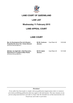

© Copyright 2026