
BelAIR_2015_KickOff_DataProcessing_KVR
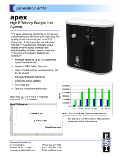
23/03/2015 BELAIR 2015 airborne flight campaigns output BELAIR 2015 kick-off, BelSPO, Brussels, March 20 th 2015 Kristin Vreys Data processing Multi-spectral (UAV): Sony NEX-6 RGB, Canon IXUS RGB/S110 RE, Multispec 4C spatial resolution: spectral range: spectral resolution: 3 to 10 cm RGB, GB+Red Edge, GB+Red Edge+NIR coarse Hyper-spectral (airborne): APEX spatial resolution: spectral range: spectral resolution: 2 to 5 m 380 nm – 2500 nm 5 nm (VNIR), 10 nm (SWIR) 23/03/2015 © 2013, VITO NV 2 Multi-spectral data processing Sony NEX-6 / Canon IXUS RGB Canon S110 RE Multispec 4C 23/03/2015 © 2013, VITO NV 3 Multi-spectral data processing » (COTS) Software: » Photoscan (Agisoft) » Postflight Terra 3D (Pix4D) » Input » Raw image data » Raw position and orientation data » Output » georeferenced orthomosaic » georeferenced Digital Surface Model » Processing Quality Report 23/03/2015 © 2013, VITO NV 4 Multi-spectral data processing 23/03/2015 © 2013, VITO NV 5 Multi-spectral data processing: ortho 23/03/2015 © 2013, VITO NV 6 Multi-spectral data processing: DSM 23/03/2015 © 2013, VITO NV 7 Multi-spectral data processing Recommendations for post-processing of UAV-data by the users Experience gained from DroneSed and iPot project to relate UAV imagery to physical properties of plants/water Pitfalls identified, processing procedures being refined: • • • • Synchronization between sensor and pos system Accuracy of position and orientation data Effect of lens distortions Radiometric calibration/normalisation of the imagery ASD measurements: use calibrated reference panels (white and/or grey) GPS measurements: Ground Control Points 23/03/2015 © 2013, VITO NV 8 Hyper-spectral data processing- overview L0/L1 processing Destriping APEX POS Destriped calibrated cubes + corresponding metadata APEX PAF (RSL) SBET processing SBET HDF5 files APPLANIX POSPAC APEX sensor model APEX spectral characteristics CDPC airborne imagery database CHB CDPC L2 processing chain: Geomodelling Atmospheric correction Spectral resampling Projection Colibri: spectral smoothing 23/03/2015 © 2013, VITO NV 9 Hyper-spectral data processing POS data processing APEX data processing • Raw data extraction • Radiometric calibration • Destriping • Boresight calibration • Spectral shift detection • Data “archiving” • Geometric correction • Atmospheric correction • Vicarious calibration • Spectral resampling • Spectral smoothing APEX L0/L1 processing APEX L2 processing 23/03/2015 © 2013, VITO NV 10 POS data processing Applanix Pospac SW Input = raw GPS position data (X,Y,Z), raw IMU orientation data (roll, pitch, yaw=true heading) gimbal data from stabilized mount GPS base station data for the time frame of the flight Installation parameters, i.e. lever arms and mounting angles Output = SBET-file, i.e. Smoothed Best Estimated Trajectory providing position (X,Y,Z) and orientation (R,P,Y) parameters for every scanline in the APEX images Boresight calibration: correct for misalignment angles between sensor and IMU coordinate system providing boresight angles ∆R, ∆P and ∆Y 23/03/2015 © 2013, VITO NV 11 Hyper-spectral data processing POS data processing APEX data processing: • Raw data extraction • Radiometric calibration • Destriping • Boresight calibration • Spectral shift detection • Data “archiving” • Geometric correction • Atmospheric correction • Vicarious calibration • Spectral resampling • Spectral smoothing APEX L0/L1 processing APEX L2 processing 23/03/2015 © 2013, VITO NV 12 APEX – L0 processing Mission *.tar APEX PAF: Level 0 Raw image cubes (DNs) Raw quicklooks (black wires) Housekeeping data (UTC of each scanline) Dark Current data 23/03/2015 © 2013, VITO NV 13 APEX – L1 processing Radiometric calibration, incl wire pixel replacement Raw image data (DNs) Dark Current data + Calibration cubes (yearly CHB campaign) APEX PAF: Level 1 23/03/2015 © 2013, VITO NV At-sensor Radiance cubes (mW/m2/nm/sr) 14 APEX – Destriping At-sensor Radiance cubes (mW/m2/nm/sr) APEX PAF: Destripe 23/03/2015 © 2013, VITO NV Destriped at-sensor Radiance cubes (mW/m2/nm/sr) 15 APEX – spectral shift detection APEX suffering from spectral shifts during flight, shifts depend on flying height/pressure/temperature During the archiving process, an automatic spectral shift detection is performed, which is: radiance-based (Gao et al., 2004), i.e. a spectrum-matching technique applied on the at-sensor radiance using a set of atmospheric absorption features SWIR atmospheric features • H2O at 935 nm • H2O at 1137 nm • CO2 at 2007 nm • CO2 at 2060 nm • CH4 at 2210 nm • CH4 at 2415 nm VNIR atmospheric features • NO2 at 430 nm • O2 at 687 nm • O2 at 762 nm • H2O at 815 nm • H2O at 935 nm 23/03/2015 © 2013, VITO NV 16 APEX - data archiving Create HDF5 file, containing: • At-sensor radiance data • Sensor metadata: • Sensor spectral characteristics (incl shift parameters) • Sensor geometry • Sensor exterior orientation (POSdata for each scanline) • Additional (quality) information Register HDF5 file in the Central Database, so it becomes available for further processing in VITO’s Central Data Processing Center (CDPC) Note that: Flight lines are cut in image parts of 3000 scan lines to ease file handling Overlap of 200 scanlines for adjacent image parts 23/03/2015 © 2013, VITO NV 17 Hyper-spectral data processing POS data processing APEX data processing: • Raw data extraction • Radiometric calibration • Destriping • Boresight calibration • Spectral shift detection • Data “archiving” • Geometric correction • Atmospheric correction • Vicarious calibration • Spectral resampling • Spectral smoothing L0/L1 processing L2 processing 23/03/2015 © 2013, VITO NV 18 APEX – Geometric correction Performed automatically in CDPC, using custom VITO software Direct Georeferencing, ortho production through forward projection using X,Y,Z,R,P,Y values originating from the SBET files, boresight angles, sensor model and DTM/DSM Resampling to a user-specified output projection system: geographic coordinate system UTM Lambert72 … Digital Elevation Models: Flanders: Europe: User DTM/DSM AGIV LIDAR DTM @ 5m resolution ASTER DTM @ 30m resolution SRTM DTM @ 90m resolution @ higher resolution 23/03/2015 © 2013, VITO NV 19 APEX – Atmospheric correction Performed automatically in CDPC, using custom VITO software (MODTRAN based, fully configurable) ‘Smile aware’ atmospheric correction, using different wavelengths for the across track pixels Sun photometer measurements provide initial values for the correction parameters (Water Vapor, Visibility, aerosol type) ASD measurements provide reference target spectra for validation: • • • • homogeneous targets size at least 5x5 pixels lambertian bright & dark 23/03/2015 © 2013, VITO NV 20 APEX – Vicarious calibration BelAir 2013 campaign: • vicarious calibration applied on the APEX data, based on ASD measurements BelAir 2015 campaign: • APEX radiometric calibration software extensively reworked/enhanced (RSL) • need for vicarious calibration to be evaluated, not applied anymore by default 23/03/2015 © 2013, VITO NV 21 APEX - Spectral resampling/smoothing Atmospheric correction = smile-aware, i.e. resulting reflectance cubes all have slightly different wavelenghts for the bands Spectral resampling to the wavelength of the central pixel, as measured during the sensor spectral calibration on the Calibration Home Base (CHB) After atmospheric correction some noise and spikes remain, in particular around the absorption regions of the atmospheric features Wavelength dependent spectral smoothing is performed to remove them 23/03/2015 © 2013, VITO NV 22 Ground teams: data to be collected Sunphoto-meter data Atmospheric correction configuration (APEX) ASD data Atmospheric correction validation (APEX) Radiometric calibration/normalisation of imagery (UAV) GPS/GCP data Improve geolocation accuracy (UAV) 23/03/2015 © 2013, VITO NV 23 Thanks for your attention! Questions ? 23/03/2015 © 2013, VITO NV 24


© Copyright 2026