
Walk 8 â Lowick Bridge
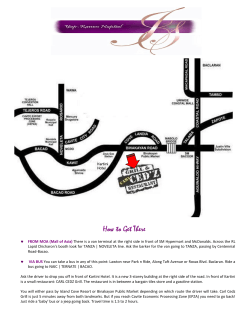
This is one of a series of walks based on the
X12 bus route. For other leaflets in this
series, at www.golakes.co.uk/travel/on-foot
select Walks from the X12 bus and specify
Borderless and Two-sided printing before
you print them. For the bus timetable go to
http://www.cumbria.gov.uk
Bus Walks
Let the bus take the strain!
Coniston - Ulverston area
The bus will stop anywhere provided it is
safe to do so.
This walk can be followed using the
Ordnance Survey Landranger 96 (Barrow-inFurness & South Lakeland) map at 1:50,000
scale. At 1:25,000 scale, you will need the
Ordnance Survey Explorer OL6 (The English
Lakes South-western Area) and OL7 (The
English Lakes South-eastern Area).
While the content of this guide is believed
to be accurate, no responsibility is accepted
for any errors or omissions. We’d be
grateful if you could send any corrections or
suggestions to: [email protected]
Produced by volunteers from Coniston in
support of our much appreciated bus
service. Supported by Coniston 14 Road
Race www.coniston14.com
Illustrations by Fiona Reeves
[email protected]
The country between Coniston and
Ulverston provides some fine varied walks.
They are ideal if you want a not-toochallenging walk, with great views, outside
the high fells. Using the bus allows you to
enjoy linear (A to B) walks. There are
currently 8 leaflets describing walks of
around 6 km (4 miles).
Walk 8
Lowick Bridge – Lowick Beacon –
Spark Bridge (6 km / 4 miles)
This varied walk has some rough sections
but most walkers can complete it in 2½
hours. It is 6 km (4 miles) long with 200m of
ascent. Route finding can be a bit tricky.
Walking boots recommended.
Walk 8
Lowick Bridge – Lowick
Beacon – Spark Bridge
Start at Lowick Bridge crossroads
Continue with the wall on your right,
near the Red Lion Pub (SD 293 865). Walk
up the lane, past the Red Lion, for 600m, to
St Luke’s Church (bench with good views of
Coniston Fells next to war memorial and
interesting old oak chest inside). In 100m,
go through a stone slip stile on the left,
signposted ‘Moss’. Cross the field and pass
through another slip stile. Turn half right
and follow the line of rock outcrops towards
the farm buildings. Go through a wide gate
and another just left of the building.
Continue between buildings to a lane. Turn
left and at the main road turn right. After
50m, cross with care to a footpath,
signposted ‘Nettleslack’.
and where the path starts descending take
the left fork contouring and gently rising
round the side of the Beacon. When you see
a wall ahead, follow it leftwards for 100m
before going 50m north to the highest point
(211m, 1¼ hrs from the start, SD 286 839).
There is no beacon here nowadays, but there
are good views, which include the wind
turbines of Lowick High Common,
Ulverston’s Hoad Monument, and in the
distance across Morecambe Bay the square
bulk of Heysham power station.
Now amidst the bracken and scrub of
Lowick Common, walk mainly southwards
and upwards through several path junctions
on the marked footpath (yellow arrows).
When you come to a fork with Roerigg Tarn
in front of you, keep right of the tarn,
aiming to the right of Lowick Beacon now
looming large ahead. Fork right at a
footpath sign, and meet a drystone wall.
Take the track opposite to Beck
Bottom. Go past the terrace of cottages
eastwards to Riddings Farm. Follow the
bridleway between the buildings. It turns
into a grassy double-walled track which
you follow all the way to the lane at
Wood End. The lane leads down, past a
converted chapel, to the main road. Cross
with care (limited visibility) and follow the
road to the junction. Turn right and walk
down to the centre of Spark Bridge,
passing The Farmers Arms and The Royal
Oak (both open all day). The bus shelter is
to the right of the bridge (2½ hrs from
start, SD 306 849).
The ancient cairn 150m to the north has
views of Coniston Water, the Coniston Fells
and many more mountains. Continue on the
path northwards and downwards, forking
right after 40m. At a T-junction turn right
towards the road. At the next path junction,
take the left fork down to a footpath
signpost, where you continue straight ahead.
After a muddy section you come to a tarn
with a metal platform. Walk along the right
side of the tarn, fork right and descend to
the road.
The Hoad Monument


© Copyright 2026