
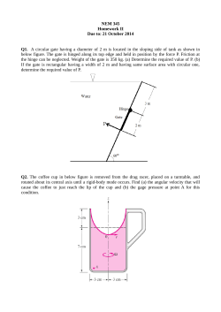
Hampstead heath Ponds Project Archaeological Survey Part 2
Historic environment assessment © MOLA 2013
Greater London
the site
0
Borough of Camden
526000
526500
0
527000
527500
528000
1000m
528500
188000
188500
525500
10km
185500
186000
186500
187000
187500
the site
Based upon the Ordnance Survey mapping with the permission of
the Controller of Her Majesty's Stationery Office © Crown Copyright.
Unauthorised reproduction infringes Crown copyright and may lead
to prosecution or civil proceedings. City of London 100023243 2013.
Scale 1:22,500 @ A4
0
1,000m
Fig 1A Site location
CAMD1224HEA13#01A
Historic environment assessment 2013
d
ton R
oa
d
ne
Ha
mp
ad H
ig
h S
t re
w
So ut hw
ue
en
Av
on
ad
Ro
nt
mo
or
sh
o
St
6
Vale of Health Pond
7
Viaduct Pond
8
Mixed Bathing Pond (No 3)
9
Hampstead No 2 Pond
hg
ate
We
s
t H
il
l
rk
Pa
y
ro
L
to
n
Ke m p la
ut
e
ill
an
ns
hi
re
H
rim
's
L
Ro ad
ow
D
f o r d Rd
lg
hb y
Ca rli ng
Bandstand
y Rd
et
ve
Keats Gro
ll
Hi
nt
Athletics
Track
10
Hampstead No 1 Pond
11
Wood Pond
12
Thousand Pound Pond
13
Stock Pond
14
Kenwood Ladies’ Bathing Pond
15
Bird Sanctuary Pond
16
Model Boating Pond
17
Highgate Men’s Bathing Pond
18
Highgate No 1 Pond
nue
A ve
Dartmouth
Park
H ig
Petanque
Pitch
Playground
and
Paddling Pool
HAMPSTEAD HEATH
STATION
Education
Centre
Supported by
Lido
N a ss ing t o n Ro ad
Keats House
24,46,
168,
C11
Changing
Rooms
me
d
oa
R
el
We
ll W
alk
d
ste
Whitestone Pond
Kentish Town
tube station and
King's Cross
10
d
Pi
46
268
HAMPSTEAD STATION
NORTHERN LINE
De nn ing
98m
9
W
W i l lo w R o
a
Dukes
Field
Fairground
Site
Preacher's
Hill
Ro a
Holly W al
k
ue
en
Pryors
Field
l
l
na
og
Fr
e
iv
Dr
h
at
He
Burgh
House
Stone of Free
Speech
Parliament Hill
(Kite Hill)
8
G a i n s b o ro u g h
G a rd e n s
W il l
ay
W
ill
H
ak
Gd
re
po
Saxon
Ditch
n
d
uth End Ro a
So
er
o o d La
ne
e
nu
Av e
ue
a ce
Te
rr
w er
Lo
nue
d A
ve
oo
ew
pl
Te
m
ns
ay
W
of t
S
dd
H i ll
H
Cr
nd
lly
Ki
h
q
5
ad
tc
E
Seven Sisters Ponds
Ro
is
w
4
te
ga
hr
Ne
ch
Lily Pond
gh
ne
Plat t ' s L ane
u r ne
Hi
La
ur
3
214
C2,
C11
Hampstead
Ponds
Camden
dn
ve
eA
The
Pryors
n
i ll
Ro
L im
ad
al k
kW
as
Hampstead
h
w
Ch urc
ce
Ro
o
New En d
Ho
na
P la
on
nn
nn
th
G
d
ay
oa
aw
R
e
en
y
F ro g
l Gd ns
re
n
G
Fi
le
is
This product includes
mapping data licensed
en
ue
from the Ordnance Survey © Crowni ll Av
h
ak
Copyrightc h 2010. License number O100023243
Av
R
re
Pa r k
po
ak
ill
er
O
H
dd
n
al
O
Ki
og
Ca
C
H ea t h St reet
s
Ca
ill
Re
ue
dn
on
d Rd
H
en
n t
di g
Fr
gbo
Secret
Garden
Vale of Health
Eas t H e
a
Te r
Leg of Mutton Pond
18
Parliament
Hill Fields
oug
k
al
W
E
s R
oa
210
268
Ho lfor
h
ad
t A
v
U p p er
nc
Ro
G
of
Judges
Walk
n
ue
cr
Tumulus
Sports
Ground
5
gt o
Av
en
rn
R
at h
B ra
o ft
d in
Re
ll y
cr
Fe
e
st H
Lan
17
95m
7
6
H a m p s t ea d G ro v e
ft Av e nu e
Croquet
o
Viaduct
Fl
st
We
La
We
se
Ho
ard
ad
Ro
He
a
th
s
u
ven e
y
t'
s
nue
lw a
Ice
House
The
Pound
o ad
130m
cr
Bird
Bridge
A
a
epe ce
ce
Jack Straw's
Castle
Ro
Play facilities
Fairground
Site
M ak
Pla
Pl a t
Tennis courts
O ak
e
t Av
hot
ld
C lo se
Rugby pitch
Highgate ponds
15
Highgate
Ponds
East Heath
W e s t He
at h R o a d
e
M
South
Meadow
Springett’s
Wood
Heath
House
Football pitch
West
H eath
Gate
Westfield
Gate Hampstead
Gate
Gate
Bog
ad
an
lf ie
Ro
14
M il
lm
Highgate
Gate
ne
at h
Radio Mast
Inverforth
House
West Heath
e
dge
Lo
ll y
H o Gdns
La
t H
e
Duelling
Ground
The
Elms
d
Pergola
ov
works to swimming
and lifeguard facilities
el
es
13
lfi
W
Cricket pitch
Sham
Bridge
Mil
2
12
16
ay
d W
115m
Gr
H il
R
Stone 11
Bridge
West
Meadow
En
y
d
oa
Sandy
Heath
th
Fountain
th
West
Hampstead
nd
The Hill
Garden
or
Sa
Pitt's
Garden
u
So
ad
Ro
dy
North End
N
Bowling green
Gate
Childs
Hill
n
Sa
Gate
Deer
Enclosure
Water
Garden
English Heritage area
Bandstand
Animal
Enclosure
a
an
1
te
Fields
Goodison
Gate
t Hill
t e Wes
Horse rides
ps
Bull &
Bush P.H.
Gate
Golders Hill Park
Gate
Mount
Tyndal
Gate
Sp
Cycle paths (shared with pedestrians)
am
Athlone House
Gardens
Hig hga
3
H
Lan e
er
210
268
Gate
Ha m ps te ad
The Orchard
Mansion Cottage
Kenwood Information Centre
Cohen’s
House
Kenwood
(English Heritage)
Spaniards
Inn P.H.
i
The P ark
2
d
Bi
Ikins
Corner
Gate
Gate
H3
d W ay
e
lg
d
ne
Pa r D
k riv
el
Flower
Garden
ad
Swan Pond
La
d R
oa
d
Av
en
ue
oa
a
Ro
Kenwood
Nursery
112m
1
's
Unmade footpaths
W
En
rk
w o o d Ro a
ds
ain
ve
Wes t H eath A
Made footpaths
rt h
Pa
ps
n
d la
Highgate
Gate
Fishing ponds
d
Br
ne
t ead L a
Stables
North Wood
4
H3
th
ar
oa
rk
Sw
No
W e s t Heat h Drive
Hedgerow / thin belt of trees or shrubs
H am p s
H3
Ro
R
The G ro v e
North Circular
(M1)
Horse rides (permit holders only)
Prospect
Hill
West Gate
Lodge
Woodland and scrub
d
Pa
he
Nor th R oad
Gate
Railway station
GOLDERS GREEN STATION
NORTHERN LINE
T
oo
Kenwood
Garden
210
H3
210
268
H3
d
Av en ue
H3
London Underground station
oa
e
Fi
tz
In g ra m
Changing
Rooms
Buses serving this point
h
rli a
ad
Pa
Ro
k
ad
ad
w ic
Ro
Hampstead Heath
Extension
ew
Ro
er
am
ood
R
h
ot
gh
Wild w
Selected outstanding views
rin
en
d
el
ue
C o ur t en ay A v e n
W
ay
Co r
Office and Staff Yard
D
to Hampstead Heath
S
ad
h P
a r k H i ll
a
te
So
H
ps
Vi
Th e B i s h o p
s
tch
m
Toilet, including toilet for
disabled people
210
268
W in n i ng
a
d H
Refreshments
R
oad
ea
Gr
d
all
tW
L
R oa
Welcome
a
op
W il
Ho
C
sR
te
hg
Car park
e
ot
at
Tu
e
an
D ri v
B ish op
il le
lb
Ta
Nev
ll
ay
ley
gs
KinWay
North
Point
ive
r
r D
rne
Hi
ay
He
W
a dw
rt h
ne
Me
Playpark
(Adventure
Playground
Peggy Jay Centre
(One o’clock Club)
G
d
or
on
Ho
us
o
e R
ad
C11
GOSPEL OAK
STATION
HH0309
s
Hampsted ponds
Fig 1B Plan of Hampstead Heath with key areas of proposed works highlighted
CAMD1224HEA13#1B
Historic environment assessment © MOLA 2013
524500
525000
525500
526000
526500
527000
527500
528000
528500
529000
Key
#
*
188500
!
(
"
)
Listed Building within HampsteadHeath
historic environment feature/findspot
past archaeological investigation
Hampstead Heath
Registered Parks and gardens
sites of special scientific interest
INVERFORTH CLOSE
Highgate Conservation Area (Haringey)
4
#
*
## #
*
**
"
) *
#*
#
3
38 42
44
41
Highgate Conservation Area (Camden)
Hampstead Conservation Area
use
57
h Ho
95
45
rfort
#
*
Inve
188000
1
#
*
Scheduled Monument
43
Historic hedge and tree lines (after City of London, 2008)
!
(
129
study area
Archaeological Priority Area
#
*
#
*
187500
39
107
!
(
#*
*
#
#*
*
"
)
#
#
*
105
40
71
#
*
94
5
84
!
(
133
66
#
*
#
*
#
*
#
*
#
*
!
(*
#
*
#"
)
#
#*
*
#*
#"
#*
*
*
#
)
#
*
#*
*
#
#
*
#
!
(
*
187000
126
114
!
(
115
"
)
"
)
"
)
2
186500
4
35
186000
36
65
110
Manor Lodge
"
)
to 4
!
("
)
97
19
Greenmoor
Heathdean
Ashdown
te
Lea-S
rdale
Silve
ps
iew
ill V
Fa
H
98
"
)
121
85
10
!
(
58
116
29
34 32
3130
25
111
!
(
!
(
!
(
132
112
133
!
(
99
!
(
"
)
23
"
)
"
)
15
!
(
!
(
133
)
!
("
104
32
12
Heathland Studio
#
#*
#*
#
*
*
#
#
*
102
28
!
(
130
7
the
8
#
*
67
24
124
!
(
#
*
122
of
ircr
t
"
)"
)
!
( !
(
22 13
"
)
16
100
123
127
)
#"
*
103
62
11
26
14
Scale 1:14,000 @ A3
59
!
(
"
)
"
)
(
"
)
"
) !
185500
21
120
!
(
#
*
!
(
119
106
House
Fleet
"
)
!
(
83
1
30
31
133
6
#(
*
!
( !
(
# !
*
118
#
*
4
!
(
"
) *
#
108
60
73
2
Vivary
!
(
113
63
Villa
Willow
Fig
House
las
Vil
ron
By
12
!
(
#
*
#
*
#
*
(
#!
!
(*
#
*
#
*
#
*
2
29
33
27
34
"
)
74
68
45 43
East
101
128
751
#
*
39
40
125
!
(
!
(
56
87
93
#
*
#
*
#
*
#
*
#
*
# *
*
#
#
*
#
*
78 61
7
70 64
96
133
86
37 54
4
95 57 34244
117
Vale House
69
49
90
9
20
#*
*
#
#*
)
# "
#*
*
#"
*
)
!
(
77
76
"
)
1
!
( 83
109
"
)
0
300m
18
Based upon the Ordnance Survey mapping with the permission of
the Controller of Her Majesty's Stationery Office © Crown Copyright.
Unauthorised reproduction infringes Crown copyright and may lead
to prosecution or civil proceedings. City of London 100023243 2013.
Fig 2 Historic Environment and designated features map
CAMD1224HEA13#02
Historic environment assessment © MOLA 2013
the site
Stanmore formation
London Clay
Claygate formation
Bagshot Beds
site outline
Fig 3 Map of the Geology of Hampstead Heath (British Geological Survey, North London,
sheet 256)
CAMD1224HEA13#03
the site
Historic environment assessment © MOLA 2013
CITY1224HEA13#04
Fig 4 Rocque’s topographical map of the County of Middlesex, 1754
Historic environment assessment © MOLA 2013
CITY1224HEA13#05
Fig 5 Historic view of Caen Wood (Kenwood) House from the south of Wood Pond, c. 1793
the site
Historic environment assessment © MOLA 2013
CITY1224HEA13#06
Fig 6 Ordnance Survey Surveyors drawings 2":mile, 1807–8
edge of map
Historic environment assessment © MOLA 2013
the site
Fig 7 Newton’s map of Hampstead, 1814
CAMD1224HEA13#07
Historic environment assessment © MOLA 2013
edge of map
the site
Fig 8 St Pancras Parish map, 1849
CAMD1224HEA13#08
Historic environment assessment © MOLA 2013
the site
Fig 9 Stanford’s map of 1862
CAMD1224HEA13#09
Historic environment assessment © MOLA 2013
the site
Fig 10 Ordnance Survey 1st edition 6":mile map, 1880s © Crown Copyright and database right [2013]. Ordnance Survey licence number 100023243 City of London Corporation
CAMD1224HEA13#10


© Copyright 2026