
6 DAAD Summer School & GIS Conference
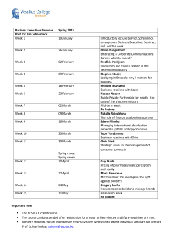
state of those resources. To make use of these data up-to-date knowledge and technical skills related to GIS technologies are necessary. 6th DAAD Summer School & GIS Conference GIS for Sustainable development and Integration Location: VNU University of Science, Hanoi, Vietnam - Summer School (06 - 08.10.2015) Conference (09.10.2015) Duration: 4 days Funding The Summer School & Conference is co-funded by DAAD and VNU University of Science (VNU-HUS) Chairmen Prof. Nguyen Van Noi, VNU-HUS Prof. Dr.-Ing. Ralf Bill, Rostock University Organizing Committee Prof.Dr. Nguyen Van Noi- Chairman Prof.Dr. Ralf Bill – Co-Chairman Prof.Dr. Nguyen Tien Giang Prof.Dr. Pham Quang Tuan Prof.Dr. Nguyen Xuan Hai Prof.Dr. Vu Van Manh Prof.Dr. Do Minh Duc Dr.Görres Grenzdörffer Dr. Bui Quang Thanh Motivation To cope with the outstanding socio-economic and environmental issues of the future such as climate, energy, transportation and demographics, geoinformation, i.e. information with a spatial reference, are essential. Geo-information plays a major role in many aspects of everyday life of citizens. The capability of GIS has been extended to include modelling and visualisation of terrain features in order that decision makers will be able not only to see the current state of the resources that they managed but also see the impacts of their decisions and the future Goal of the Summer School & Conference The summer school and conference shall introduce recent developments in GIS for sustainable development and integration, both in theory and practice. The summer school shall provide a foundation for further studies and implementation activities in sustainable development, exchange knowledge, and enhance cooperation in education and scientific research between German and Vietnamese partners. Themes of the Summer School & Conference Geographic Information Systems (GIS): Introduction, Technology, Analysis methods, recent developments - Spatial databases: Focus on spatial organization and structuring of geo-information, hands on PostgreSQL - UAVs, 3D - Spatial Data Infrastructures, Standardisation and Servicens (ISO and OGC) - GIS and Internet technologies, Web-GIS - GIS applications: resources management, disaster management, regional planning, public health, environment and climate change. - Education, traning and research on GIS applications Lecturers of the Summer School & Conference Target groups Master students, PhD candidates, government officials with a scientific background in Urban and Regional Planning and Development, Environmental Sciences & Management, Environmental Monitoring, Architecture & Planning, Geography, Computer Science and others. Application Applicants for the Summer School should have Bachelor or Master degree in a relevant subject area (e.g. Urban and Regional Planning, Environmental Sciences & Management, Environmental Engineering, Computer Science, Water management, Geography, etc.). Applicants studying in a Masters programme or doing a PhD thesis or working for government agencies are preferred. Any applicant must be able to understand and speak English fluently (TOEFL, IELTS, other English Certificates). An application giving details of qualifications and language experience shall be made using the form provided soon on our webpage. Registration should be done online via: Full applications should be sent to: [email protected] Time schedule Summer School applications: deadline is 30.08.2015. Successful applicants will be informed by 15.09.2015. Contact information in Vietnam Lecturers are experienced experts who come from the Rostock University (FRG). Selected presentations from Vietnamese colleagues will link the themes with regional research issues and applications. Prof.Dr.-Ing. Vu Van Manh VNU University of Science 334 Nguyen Trai, Thanh Xuan, Hanoi, Tel./Fax: +84-35583305/2872 Email: [email protected] Structure of the Summer School & Conference Contact information in Germany The Summer School includes lectures, exercises and examinations. Successful participants will receive the certificate of attendance equivalent to 3 ECTS. The Summer School closes with a GIS Conference th and closing ceremony on 09 October 2015. The programme of the Conference is published separately. Prof. Dr.-Ing. Ralf Bill Rostock University Chair of Geodesy and Geoinformatics Justus-von-Liebig-Weg 6 D-18059 Rostock Tel./Fax. ++49-381-4983200/3202 Email: [email protected] 6th DAAD International Summer School & Conference GIS for Sustainable Development and Integration 06th – 09th October 2015 VNU University of Science. 334 Nguyen Trai, Thanh Xuan, Hanoi Tuesday (06.10.2015): Room 418 T1 Building, 334 Nguyen Trai, Thanh Xuan, Hanoi Opening Ceremony 8:00: Welcome addresses given by: - Prof. Nguyen Van Noi, Rector of VNU-HUS - Prof. Ralf Bill, Rostock University - Ms. Anke Stahl, Head of DAAD Hanoi 8:20: Introduction to the program 8:30: Short introduction of the invited participants 8:45: Icebreaker event 09:00: Lectures Geo-Information Systems (GIS) - An Introduction Lecturer: Prof. Dr.-Ing. Ralf Bill Topic Type of Lecture Duration Introduction, motivation Basic definitions, spatial Lecture 45 min references, data types and dimensions IMAP - going through the Lecture 45 min processing chain Spatial data source in Interactive, team 30 min Vietnam work Spatial data modeling and analysis Spatial data modeling Lecture 30 min Spatial data analysis Lecture 30 min Data modeling and interactive analysis demonstration Norms and specifications 30 min ISO and OGC – norms Lecture and specifications Recent developments of GIS 60 min Recent GIS developments 60 min Lecture Wenesday (07.10.2015) Remote Sensing from satellite and airborne imagery Lecturer: Dr.-Ing. Görres Grenzdörffer Topic Type of Lecture Duration Satellite Remote Sensing Introduction and remote Lecture 45 min sensing technology basics Where can I obtain (free) satellite data interactive demonstration 30 min Analysis of Satellite data Lecture 30 min Applications of satellite remote sensing Lecture 30 min Airborne Remote Sensing Introduction Lecture 30 min Digital airborne cameras Lecture 30 min Visual image interpretation / stereo images Mono-/stereo- and multiimage measurement and computation (2D- to 3Dcoordinates) Lidar interactive demonstration Lecture 30 min Lecture 30 min Applications of airborne remote sensing Lecture 30 min 30 min Thursday (08.10.2015) Unmanned Aerial System (UAS) Lecturer: Dr.-Ing. Görres Grenzdörffer Topic Type of Lecture Duration UAS Introduction / Technology / Lecture 45 min Categories Aerial UAS survey planning interactive 45 min demonstration UAS - a modern tool for Lecture 45 min Geoimaging Georeferencing of UASImages Standard products of UASphotogrammetry Applications of UASphotogrammetry Interactive demonstration Lecture 45 min Lecture 45 min 45 min Friday (09.10.2015) Scientific Conference (09.10.2015) on “GIS for Sustainable development and Intergration” 08:00: Registration 08:30: Opening 08:30: Welcome addresses - Prof. Nguyen Van Noi, Rector of VNU-HUS - Prof. Ralf Bill, Rostock University - Ms. Anke Stahl, Head of DAAD Hanoi - Prof. Phung Xuan Nha, President of VNU 09:20: Photo & Coffee break 09:45: Categorise Parallel Sessions Session A: GIS technology Session B: GIS, remote sensing in environmental studies and natural resource management Session C: GIS, Remote Sensing in regional planning Session D: GIS & RS in Natural Hazard study Session E: Advanced approaches of GIS and RS Keynote speakers: - Prof. Ralf Bill (Uni Rostock) - Prof. Nguyen Xuan Hai (VNU-HUS) - Prof. Pham Quang Tuan (VNU-HUS) - Prof. Nguyen Hong Phuong (VAST) - Prof. Vu Van Manh (VNU-HUS) 10:00: Morning Parallel Sessions 12:00: Lunch break 13:00: Afternoon Parallel Sessions 15:00: Panel discussion 16:00: Award Certificate & Closing Ceremony for Summer School & Conference 16:05: Prof. Nguyen Van Noi 16:15: Prof. Ralf Bill 16:20: Ms. Anke Stahl 16:25: Award certificates 16:40: Speech of a participant 16:45: Last words of the organizers and coordinators 16:50: Group photo 17:00: Farewell party


© Copyright 2026