
1 Rangeland Rehydration Field Guide
Rangeland Rehydration
2
Manual
by
by
Ken Tinley
Tinley &
& Hugh
Hugh Pringle
Pringle
Ken
a.
b.
c.
Frontispiece: Geomorphic succession - breakaway land surface replacement sequences (similar at all scales).
(a) Laterite breakaway of ‘old plateau’ sandplain surface (Kalli LS) supporting wattle woodlands of wanyu and mulga.
(b) Small breakaway of erosion headcut in the duplex soil of a footslope.
(c) Micro breakaway of topsoil the same height as the camera lens-cap. In each example the upper oldest land surface is
eroding back and contracting. Newest land surface is the lower pediment in (a), and the exposed subsoils in (b) and (c).
2
Rangeland Rehydration 2:
Manual
by
Ken Tinley & Hugh Pringle
3
Rangeland Rehydration: Manual
First Printed: December 2013
Second Printing (with corrections): March 2014
Initially prepared by Red House Creations
www.redhousecreations.com.au
and Durack Institute of Technology
www.durack.edu.au
Final document by Printline Graphics
Fremantle WA
Project Development Co-ordinator
Bill Currans
Rangelands NRM
www.rangelandswa.com.au
Digital or hardcopies of these two handbooks can be ordered from Printline in Fremantle, Western Australia 6160.
Phone: (08) 9335 3954 | email: [email protected] | web: www.printline.com.au
Ken Tinley - [email protected]
Hugh Pringle - [email protected]
Disclaimer: The findings and field evidence from across the rangelands, statements, views, and suggestions in this Field Guide
are those of the authors, or others referred to, and may not accord with any officially held views or political positions.
Photos and illustrations, except where otherwise acknowledged, are by Ken Tinley.
Cover photo by Janine Tinley. EMU logo by Lynne Tinley.
© EMUTM This work is copyright. Apart from any use permitted under the Copyright Act 1968, no part may be reproduced by any
process, nor may any other exclusive right be exercised, without the permission of Dr Ken Tinley and Dr Hugh Pringle (Ecosystem
Management Understanding (EMU)TM, 2011).
4
Dedication
This manual is dedicated to Karen ‘Kaz’ Collins (nee Johnson). Kaz was a passionate landscape ecologist and an
enthusiastic supporter of the EMU/ESRM process. She worked for many years in the rangelands of other parts
of Australia before moving west to work in ESRM where she was instrumental to the success of that project.
Her infectious enthusiasm and disarming smile won over all who met her. The Murchison/Gascoyne region of
Western Australia and the broader Australian rangelands lost a patriot of sustainable landscape management
when Kaz passed away recently. This manual is a tribute to her passion and the arid country that she loved.
5
Contents
Preface8
Acknowledgements10
Introduction11
[A] Appreciating What Pastoralists Have to Deal With13
(1) Stewardship of the Rangelands13
(2) Conversation with a Pastoralist15
[B] The EMU Approach19
(1) Origin and Development of EMU19
(2) Synoptic Ecology by means of Salient Factor Analysis
19
(3) How to Run the EMU Exercise
24
(4) The Mapping Exercise: Premise of the Graphic Approach
26
(5) The Indispensable Air Perspective30
(6) Drainage/Fluvial Ecosystem Units and Sub-units
30
(7) Indicative Monitoring32
(8) Preparedness for Adaptive Management32
[C] Key Landscape Features and Processes
35
(1) Catena Series35
(a) Landsystems35
(b) Soils38
(c) Soil Moisture Balance39
Summary40
6
Contents
(2) Drainage Dynamics
41
(a) Base-levels41
(b) Erosion and Gravity Slumps42
(c) Channel Necks and Tributary Junctions42
(d) Floodplains43
(e) Local Valley-side Tributaries43
(f) Ponding/Run-on Surfaces44
(g) Stream Capture45
(3) Soft Coast Dynamics: Dunes, Deltas, Estuaries and Wetlands
49
(a) Coast Buffer Zone49
(b) Dune Type Features on WA Rangeland Coasts
50
(b) Specific Guidelines51
(4) Ecological Succession: Cascading Effects52
(a) Erosion52
(b) Overgrazing/Overbrowsing54
(c) Fire55
(d) Berry-bird Mediated Thickets66
(5) Ecojunction Benchmark Paddocks70
[D] Landscape Repair72
[E] Ecology in the Round74
[F] References and Background Reading75
[G] Appendix 1: Definitions and Explanations
7
87
Preface
This manual is for extension facilitators and is a complement to the Field Guide for landholders (pastoralists
in particular). Facilitation of field-based management skills is a hands-on exchange of knowledge and
know-how between the visiting facilitator and resident pastoralist. By means of the participatory EMUTM
(Ecosystem Management Understanding) approach a reciprocal learning process occurs focused around a
baseline mapping exercise in which the landholders (often husband and wife) draw their local knowledge on
map overlays in answer to some 15 questions (Table 1).
The mapping is a simple yet profound process. It is the graphic means of organizing pastoralists’ local
knowledge in relation to the landscape patterns, processes and linkages. This visually emphasizes present
stage or condition, identifies where they want to go, forms the basis for keeping track of change, and with
ongoing monitoring, tracks progress towards their management goals. Most importantly it forms the
template to experiment, learn and adapt. As the composite of map overlays is a graphic expression of their
local knowledge, the process becomes owned by the participants.
EMU facilitators do not teach or lecture but rather demonstrate and expose participants to other ways
of seeing and doing things in a holistic integrated way in landscapes that are continually changing. They
promote thinking and practising of creative management based on an expanding ecological awareness and
knowledge. EMU facilitators learn from pastoralists and improve their capacity in a positive feedback loop
of reciprocal learning.
An initial doubt in anyone starting out in the field of facilitation with people who live and work on the land
is that ‘I don’t know enough’. A basis to gaining confidence is the acceptance that nobody knows everything,
but that there is the need to know the key elements of the subject and build on these. In the rehydration
component of ecology the key is ‘knowing where to tap’ (Box 1).
The targets of extension are the pastoralists and pastoralism together with land health and biodiversity
conservation. The EMU approach has been tried and tested over 12 years in a variety of rangeland
communities, including Aboriginal owned stations, in Western Australia and Northern Territory, and more
recently in South Australia and Namibia. It is important to remember that pastoralists generally have a
profound distrust of government agendas and policies that for them are generally disabling rather than
enabling. Hence all the station information and local knowledge mapped by the pastoralist and partner
remains the property of the present or subsequent lease holders, i.e. the map recorded information belongs
to the particular station.
The training of facilitators will comprise of a weeks field induction or alignment course on a station covering
subjects such as landscape ecology, pastoral management, and how to run station workshops. The latter
requires an understanding or an appreciation of human behaviour and adult learning processes to discover
how to interact to motivate participants toward creative and practical outcomes (Ison & Russell 2000;
Sonnekus & Breytenbach 2000).
Alignment between participants in any process allows for effective and sustainable utilisation of resources –
particularly when they come from different cultures (Sonnekus & Breytenbach 2000).
The indoor alignment phase (mapping knowledge on clear overlays) is followed by on-station experiential
learning; exploring together with field ecologists and pastoralists how to read the signs of the land and
their meaning, both from ground and aerial perspectives. Subjects covered would include: introduction
to the station ecosystem framework by means of overlay mapping, soil and vegetation types, landsystems,
succession and indicators of condition and trend in a drainage unit context.
In this manual we have created a reference of factual, conceptual and philosophical information as well as a
broad ecological background for facilitators to use together with their own knowledge and ongoing experiences.
8
As the EMU approach is innovative and multidisciplinary and deals with different peoples and cultures, it has
to be adaptable to fit different circumstances. Good EMU facilitators have to be “all rounders” to understand
the basics of many disciplines related to community based Rangelands Natural Resource Management
(NRM) and team players to access additional expertise as required.
The most effective means of spreading ecological literacy across the rangelands is by means of the Pyramid
System of learning where one facilitator trains say 6 pastoralists from several adjacent districts. When
proficient, those individuals who turn out as best facilitator material then each train 6 more pastoralists in
their own district and so on. The most effective interactive knowledge transfer is pastoralist to pastoralist.
This leaves the original facilitators free to move further afield and develop the same process, and in addition
to be available for running refresher courses.
It is important to remember that though ecosystems are extraordinarily complex, the first and ultimate
orchestrator of vegetation patterns, forms, successional processes and land health is the movement of
moisture in a landscape. This needs to be understood in the context of drainage process units.
Soil moisture is the driver of almost everything in rangelands. Well managed, it invigorates ecosystems,
livestock and wildlife as well as enterprises and rural communities. Water is the lifeblood of rangelands and
its management is the focus of this initiative. We acknowledge that there are other, complementary issues
such as ecologically-based grazing strategies and smart marketing, but none of them can be effective if the
rainfall is not captured into productive soil locally.
KT & HP
The order of figures is subject related, not in order of citation.
9
Acknowledgements
This initiative owes much to the persistence of Greg Brennan, Department Agriculture and Food WA, who has
never let up the pressure on us to consolidate Ecosystem Management Understanding (EMU) into a form that
can be extended more widely than we can do first hand. Without Greg’s persistence it would not have happened
and we are deeply grateful to him for his ongoing support of our work.
Many thanks to Rangelands Natural Resource Management, Western Australia (WA) who have funded this
work through Caring for Our Country, a Commonwealth Government initiative. Brian Warren, General
Manager of Rangelands NRM WA, has been particularly helpful and understanding as we have expanded the
project well beyond original plans for a focused rangeland rehabilitation guide.
Great thanks to Lynne Tinley for her ongoing typing and editing support, and for being a sounding-board for
ideas. Thanks to our trainees who reinvigorated the EMU process: Peter-Jon (PJ) Waddell, Annabelle Bushell
and Sally Black. PJ Waddell has again, as with the Rehydrating the Rangelands Field Guide, performed a vital
service of diligent editing.
For computer-graphic transference of our mock-up document to a subfinal stage great thanks to Kay McAuliffe
(Red House Creations) and the Durack Institute of Technology, Geraldton. To Danielle Cameron-Brown of
Printline Graphics, Fremantle, our gratitude for refining the final document to publication quality stage. Also
thanks to Nicolai Handevitt-Haar, director of Printline, for his technical guidance at all times.
Finally, we acknowledge the excellent job done by our ESRM successors and hope we have included their
developments adequately.
Box 1: Knowing Where to Tap
Knowing Where to Tap
Ever hear the story of the giant ship engine that failed?
The ship’s owners tried one expert after another, but none of them could figure our how to fix the
engine. Then they brought in an old man who had been fixing ships since he was a youngster.
He carried a large bag of tools with him, and when he arrived he immediately went to work. He
inspected the engine very carefully, top to bottom.
Two of the ship’s owners were there, watching this man, hoping he would know what to do. After
looking things over, the old man reached into his bag and pulled out a small hammer. He gently tapped
something. Instantly, the engine lurched into life.
He carefully put his hammer away. The engine was fixed!
A week later, the owners received a bill from the old man for ten thousand dollars. “What?!” the
owners exclaimed, “He hardly did anything!”
So they wrote the old man a note saying, “Please send us an itemised bill.”
The man sent a bill that read:
Tapping with a hammer………..$2
Knowing where to tap………….$9,998
Effort is important, but knowing where to make an effort in your life makes all the difference.
Susi Cerati
Women Spirit magazine n.d.
10
Introduction
At the outset it must be stated that these two handbooks on rangeland rehydration are not just about remoisturising landscapes. As everything is connected to everything else in ecology, it would be quite pointless
rushing around putting in sieves all over the station when the groundcover is depleted and there is little total
grazing control or any of the other fundamental management requirements such as: conservative stocking
rates that maintain pasture vigour, cover and topsoils (permeability and decreased runoff); mosaic burning;
seasonal alternation of upslope grazing in the dry and downslope in the wet; other forms of intermittent grazing
(e.g. Bartle 2002; Le Houerou 2006). If the grazier’s response to rehydration is like another new fad or gimmick
it becomes a pointless exercise and if it disappoints (or fails) is dismissed as a waste of time.
Without groundcover of perennial plants the tiled-roof effect remains and soil moisture recharge does not
occur. Perennial grass cover and intact topsoils are mutually dependent. There is unlikely to be any help
from rehydration techniques if “more of the same” pastoral management continues. That is why successful
demonstration examples of different methods in a variety of terrain situations is fundamental to where and
how in a landscape rehydration can be successful. After 150-200 years of pastoralism in Australia there is an
imperative for ecological conservation management of the rangelands to be applied - in which maintenance of
biodiversity, and its role in supporting ecological and economic resilience, is paramount.
Where and how to recover drainage, soaks, springs and floodplains is easy to understand and apply whether
one is an illiterate tribal herder or a scientist. The advantage the tribal herder has is by being nomadic. Not
confined to one place or to one station, they have room to manoeuvre and the see-sawing of their seasonal life
changes have much larger swings. By migrating, well-used or over-used country has a chance to recover and a
variety of feed gets the chance to survive and set seed in different habitats, which in turn can maintain healthy
stock and people (Box 2).
Whereas pastoralists confined to paddocks and one or two landsystems means the positive or negative
tipping points are more sensitive or finely responsive. Hence, more easily the potential for degradation to tip
into expanding, longer lasting, down-swings (or spirals) with habitat simplification and the resultant loss of
ecological and economic resilience. This means that all round healthy sustainable pastoralism has the best
chance of being realised where it is managed according to ecological and biodiversity conserving strategies
based on an intimate local knowledge of the ‘Nature of Place’.
In order to do this, pastoralists need to learn more about the make-up of their station landforms and vegetation,
and how they function interactively. It’s no longer enough for a grazier to know a few local plants and little
about the soils. To be able to identify the precursor indicators of soil erosion and successional changes in plant
cover composition for example is vital. Are the run-on areas viable? Where is the erosion? Is it spreading or
healing? Is the woody weed invading in key pasture areas or only where the land has been disturbed by roads
and tracks? Keeping a finger on the pulse by monitoring and recording the changes taking place provides the
information feedback loop that is vital for tracking and keeping station health and integrity in balance. There is
a need to deepen understanding and enhance management adroitness for adapting to change.
If you are a tribal pastoralist it is simple to follow the four basic rules about rehydrating the land: (1) ‘Where’ to
intervene in the drainage, (2) look upstream first to see if the drainage needs calming before doing anything,
(3) look downstream to see where you want the flow to go when it passes the ‘where’ intervention site, and (4)
only then, the ‘how’ (e.g. brushwood filters and /or stones and logs), or (5) if too hard – migrate. That is all
nomadic pastoralists need to know about rehydration because they already have intimate ecological knowledge
of their wide-open landscapes without fences.
The situation in the confined geographic space of a fenced-off and paddocked station is totally different. Here
only part of the station, maybe less than half is suitable for stock rearing. In order to manage in an ecologically
holistic way the pastoralist would need to understand the ecological make up and functioning both within the
station and its surroundings. If the station’s location is in a major catchment it is important to know its situation
in regard to downstream or upstream effects.
11
In order to manage in an ecologically holistic way the dynamic ecological context is that bounded by drainage
divides at all scales – down to the smallest tributary. Pastoralists now have to do something new in regard to
landcare – more whole, more interrelated. Just applying rehydration enhancement by itself can be a pointless
exercise if the management remains ‘more of the same’ with little knowledge or care of land processes, and
a lack of total grazing control.
The Australian pastoralist in contrast to the tribal extended family may only have his partner to rely on. This
results in a much more complex juggling of priority tasks that have to be done (Figure 7). Now the four
basic rules of rehydration expand into a plethora of issues, often particular to the station, that need to be
identified and dealt with (Section D in Field Guide). This is where EMU has for the past 12 years introduced
pastoralists on how to use a map-based approach for recording their station’s particular landscape make-up,
to identify problems and to record monitored information identified from aerial and ground traverses.
Government landcare and community support is crucial. Demonstrating examples of different methods
in a variety of landscape situations, and mutual aid and sharing of knowledge amongst landcare members
is fundamental. It is important that some structure is developed to support increased understanding, but
rather than be led by scientists, it needs to be a genuine partnership between pastoralists and scientists.
This will ensure relevance of research findings and also avoid really incongruous ideas gaining credibility.
Transfer of information between local pastoralists, regionally and wider is critical. Knowledge must be
nurtured, not controlled.
Some particularly successful pastoralists do little formal monitoring of their land. However, they are so
intimate with their landscapes that they get away with it. Most pastoralists are not in this situation and
some form of monitoring will enhance their understanding. The EMU Landscape Monitoring project was
developed with pastoralists, for pastoralists. It complements recorded observations on a map overlay that is
kept out and accessible all year. The monitoring makes pastoralists test their interpreted surveillance at the
key places where they have chosen to “put their finger on the pulse”. It also makes them focus on tracking
any changes in ecosystem function, thus enabling adaptive and improved management responses.
What is most important about the EMU approach for pastoralists is that it is a journey, there is no “end
point” – learning is continuous, situations change and improvement is always possible. EMU is an innovative
process that can enhance the quality of life for all ecosystem managers.
12
[A] Appreciating What Pastoralists Have to Deal With
(1) Stewardship of the Rangelands
The island continent of Australia covers some 7 682 300 square kilometres, of which nearly three quarters
(5 761 725 sq.km) is used as pastoral rangelands. This represents probably one of the largest areas on Earth
in which the production of protein is based on wild vegetation from pollution-free pastures. In other words
stock production is not based on feedlots dependent on grains and legumes, that are human staple foods,
and which originate today from vast fertilizer-dependent monocrop fields often, in the case of soybeans,
requiring the elimination of huge swathes of rainforest.
Ecologically sustainable rangeland management, which maintains or enhances the variety of habitats, vegetation
and natural processes on a station, is the fundamental basis to the conservation of biodiversity. A high diversity
imparts adaptive resilience to a system, unlike a simplified system that is vulnerable to change. Enhancing
resilience of station landscapes, in particular the run-on areas, is critical for adapting to climate change (Friedel
et al.1990; Nix 2004; Walker & Salt 2006; Pearson 2008; NRM Ministerial Council, Canberra 2010)). For an
early view of adaptation see Figure 6.
However, encouraging and enabling pastoralists to adapt and become ecologically adroit managers is not
enough. Government agencies are also in need of adapting policies and guidelines that are real to the
predicament in the Outback. Not least, the need for the land overseeing agencies to develop a more effective
coordinated approach to the conservation of coasts, water, soil, native vegetation and wildlife (e.g. Westoby
et al. 1989; Wilcox & Burnside 1994; Abel et al. 2000; Stafford Smith et al. 2000; Flannery 2012).
Pastoral stations are usually family run businesses on very large properties. With few staff to help run the
station there is typically very little time to attend to much else except management of livestock and the
supportive infrastructure. Pastoralists are generally multi-skilled and involved in dealing with a large variety
of subjects and aspects as exemplified by a perusal of the WA Pastoral Memos and the Australian Rangelands
Society Biennial Conference proceedings. But with few hands they are confined to the stock, infrastructure
and income generating treadmill, and without the funds to hire more staff are trapped. Anything additional
is viewed by some as a threat or slight to their ways of doing things. Just the word “conservation” for example
can provoke the terse response “that’s the governments’ job they own the land – we have to survive. We are
already overburdened and have no time for more impositions” (Figure 7).
Due to the short-term outlook of the political election process, policies tend to be subservient to appeasing
voters and elected parties are reluctant to apply or monitor the regulatory guidelines and legislation, for
example the soil conservation act, to protect the land from unacceptable damage (Roberts 1989). There is also
no government on Earth that has the sustainable financial capability for protecting large numbers of parks
and reserves over vast landscapes as ecologically ‘comprehensive, adequate and representative’ (Hopkins
et al. 1996) examples of a country’s biodiversity and natural resources. Nor do they have the capability for
continuity of control, management and research at this dimension due to the changeableness of politics,
policies, markets and the economy. Conservation is typically one of the first government functions to be
affected in times of economic downturn and personnel retrenchment (Wilcox & Burnside 1994; Walker &
Janssen 2002).
That means, as elsewhere in the world, that the actual and potential stewards and conservators of the
rangelands of the Australian continent are the pastoralists and their families who live on the stations. They
are in the frontline, the day-to-day interface, with the ‘wild nature’ of the Outback rangelands.
To sum up: A system of conservation based solely on economic self-interest is hopelessly lopsided. It tends to
ignore, and thus eventually eliminate, many elements in the land community that lack commercial value, but
that are (as far as we know) essential to its healthy functioning. It assumes, falsely, I think, that the economic
parts of the biotic clock will function without the uneconomic parts. It tends to relegate to government many
functions eventually too large, too complex, or too widely dispersed to be performed by government. An ethical
obligation on the part of the private owner is the only visible remedy for these situations (Aldo Leopold, 1949).
13
For the maintenance and recovery of effective health and integrity of ecological diversity on stations, the focus is
on the main drivers of habitat change. These drivers, that are within the management capabilities of pastoralists
are: (a) stock grazing strategies that maintain topsoil and ground cover, particularly of perennial grasses, (b)
erosion control in core grazing habitats and their infringing influences, (c) reconnecting and recovery of
riverine and run-on areas, and (d) fire, flood and drought preparedness (Le Houerou 2006).
For pastoralists to become effective land managers they need to learn more about the ecological functioning
of their station and its relationships with the surrounding country. They also need to find ways to devise
best-fit ecological strategies for the particularities of their station that will enhance conditions for their
pastoral enterprise.
For this they do not have to acquire a university degree, rather, they need to develop a keen interest and
curiosity in close observation, in interpretation, and in monitoring of natural processes and the make-up of
their country so as to become competent naturalists, as exemplified by illiterate nomadic pastoralists on the
southern margin of the Sahara (Box 2).
Box 2: West African Nomadic Herders
West African nomadic herders knowledge of their stock and arid 100 – 300mm southern margin
pastures of the Sahara Desert (Sahel Zone).
Systemic monitoring of environmental changes in climate, and quality and quantity of forage
helps the herders take advantage of green flushes of forage, or to avoid overcrowded areas. Even
from a distance the Wodaabe herder can judge the intensity and significance of greenness of a
pasture. He will also monitor the faeces of livestock, milk yield, animal weight and the number
of cows in heat, to tell him about how well animals eat, and therefore the quality and quantity of
forage. A very thorough study of traditional environmental indicators has been done among the
Fulani of Mauritania.
They evaluate the quantity of forage by looking at the density and height of grasses and herbs,
the portion of land covered by each pasture type, and the tree cover, and compare all of this
with the need of livestock on the pasture. They evaluate the quality of range through 1) soil type
and capability for each type of pasture; 2) presence or absence of individual forage species, and
their palatability to different livestock; 3) degree of greenness of forage; 4) presence or absence
of wildlife, for example good pastures also support gazelles, hyenas, lions, wild boars, etc., while
the ones that have elephants, giraffe, ostrich are good only in the dry season because of excessive
humidity and disease, and 5) behaviour of domestic animals, e.g. a good pasture is indicated by
cattle who eat with good appetites, are not restless at night, sleep on their right size (full stomach
not pressed), breathe slow but deeply, have beautiful skin and hair, are not rushing to pasture
in the morning, do not need to be forcefully restrained during the morning milking, increased
number of females in heat, and faeces are wet, not friable, and have little undigested matter.
When going into a new unknown pasture, the Fulani herder will take the animals to pasture
for seven consecutive days in each of four major directions, and will compare the pastures by
evaluating the effect on the animals. The Fulani know that vegetation changes can be caused
by overgrazing, drought, bush fires etc., but say that droughts cause the greatest change. There
are also many indicators for monitoring the degradation of pastures. The Maasai and Wodaabe
look at milk yields, and the Samburu observe grass and browse availability. Among the Fulani
of Mauritania, degraded pastures are indicated by Cassia occidentalis and Calotropis procera,
and the presence of vividly coloured lizards.
M.Niamir 1990: page 30
14
The sustainable conservation of biodiversity has become ‘one-eyed’ and habitually overlooks the essential other
eye for its realisation, and that is the human component – human diversity (Krockenberger 2000). An enabling
environment needs to be developed in the rangelands that addresses how livelihood and social issues can
begin to support the expression of human interests, skills, talents, creativity and innovation in relation to the
many natural resources of the rangelands. In other words the need is for human expertise diversification, more
enterprises by more people, which supports and enhances ecologically sustainable pastoralism in the Outback.
It is not the emptying of the outback that is going to conserve its biodiversity, but rather its revitalisation
through having more families with different suitable talents and skills living on the stations and in country
towns who have the potential towards helping recover land health through ‘incentive driven’ conservation
(Milton et al. 2003; du Toit et al. 2004; Hutton & Leader-Williams 2005).
Enterprise diversification within the communities, whether it be more motor mechanics, animal handlers,
bookkeepers, teachers, naturalists, camel harvesters and rehydration teams would enable pastoralists to have time
for their own wellbeing and to learn new creative approaches or strategies. Young people growing up on stations of
course have a variety of interests and talents that they think can only be realised in the city – they do not necessarily
want to go back after high school or university to do the same things that Dad and Gramps did. However, nature
based income-generating enterprises, including facilitation of ecological management and rehabilitation, could
provide exciting and lifetime interests as well as helping to recover and manage the rangelands.
(2) Conversation with a Pastoralist
Ken called in to visit David on his sheep station in the mulga country. David had earlier taken part in the
EMU exercise and completed ground and air traverses of his station.
D: “After you fellas went off to run the EMU exercise on another station, I was left in a quandary; where
to start to get away from the degradation trap of continuous grazing. It’s going to need re-arranging
water points and paddock connections…
I am running relatively low numbers of sheep compared to my neighbours, but I was devastated by
the size and number of bare, sheet-eroded areas shown up by our air traverse. On our ground visits,
you will remember, there is still a good variety of bluebush and saltbush in different areas, but the
station obviously needs a rest to recover.
Anyway, let’s take a walk. I need to check on the piles of dry sandalwood I have been collecting to
increase my income; it has to be ready for trucking tomorrow. If I don’t do it myself, some stranger
gets a permit from the Forest Products Commission to harvest my station’s sandalwood, and they pull
out living trees as well as taking the dead wood! Where is the regrowth supposed to come from?
It makes me snake mad! Sandalwood is really still a colonial crop, now owned by the State, and from
which WestCorp earns between $8000 and $12000 per tonne from Asian markets. Out of this I get
$1100 per tonne! You would think the State is earning more than enough from all the mining, to have
to scrimp and scrape what is actually part of a station’s resources. Sandalwood is quite common on my
station but young plants are as rare as….”
K: “That’s right, David. From my field observations over the last six years across the Gascoyne/Murchison
and northeast Goldfields there is a dearth of different age replacement of sandalwood. Together with
over abstraction since pioneer times and the high palatability of the young plants to all herbivores,
from rabbits to camels, there is also the extinction of the burrowing bettong that used to cache the
seeds, and the killing of emu by some pastoralists because they break fences. Sandalwood needs help
in order to become re-established.”
D: “I tell you what, if sandalwood was a station-owned resource and I could sell the dry wood for the
kinds of earning the State is getting, I would sell off all my stock, except for a small herd for our home
consumption, and plant back sandalwood in all the bushclumps where they like to grow. This station
also has a good lot of emu that you know are important for spreading the seeds. That would be my
answer to giving this country of mine a rest to heal itself.”
15
K: “David, do you know anything about the value of emu as a resource?”
D: “Well, I know that in earlier times their skins made the very best leather jackets, their meat is good, and
their oil is valuable, used in sports therapy and injury treatment, also in veterinary work especially with
horses.” (See Frapple & Hagan 1992).
K: “Do you know what emu oil sells for these days, and how much oil is produced by one healthy adult emu?
No, well, listen to this – a litre of oil now sells for $154, and the fat from a fit adult can be rendered down
to around 7 litres of oil, that means…”
D: “My God, don’t tell me – that one adult emu is worth about a grand!!! And they die in thousands along
the vermin fence in a drought – what a tragic waste, bloody hell.” (Figure 1)
K: “Yep David, but the law is that you can only farm emu in paddocks where they trample the place out,
are fed on turkey pellets, and I’m told are prone to worm infestations. You are not permitted to harvest
free-range emus where they feed themselves on a large variety of foods and disperse seeds. Free range
they would be easy to cull humanely using a corral with plastic wings to direct them into, like they
do with ostrich. There would of course be ‘bag limits’ so as to protect the viability of the populations,
which are typically nomadic. Think of changing the bias in the mulga country from stock to native
plant resources, emu and roo harvesting! This could have an enormous multi-layered healing response
toward the recovery of country. For example in the West Australian of 25 August 2007 the news headline
was ‘Roos turn from pest to $230m industry in SA.”
D: “That’s impressive. But here in the mulga country for that to happen many people will have to overcome
habitual hates against emus and roos they call rubbish animals because they break fences and eat the
pasture. Now they are more worried about the feral dogs. What can be done about the increase in
woody weeds, maybe only goats and camels will eat them? Anyway, these days with the increase of cattle
replacing sheep they may take grasses and the scrub as well?”
K: There’s an old saying that a weed or rubbish plant or animal is ‘one whose value has not yet been realized’
(Figure 2). What is of concern regarding roos and emus is that the fencing for cattle includes an electric
and barbwire strand which traps the animals and reduces them to a pulp. Sheep fencing still allowed
them to be nomadic, now they are trapped, and their populations could decline, I am not sure there is
any monitoring of emu populations, for example.
D: Listen, most pastoralists are strapped for time, fully involved in maintaining infrastructure and dealing
with stock. Anything like broken fences or gates left open, especially in the summer heat, that forces
us to do any additional work means our responses are on a short fuse – what you would call bloody
irrational.
K: What the rangelands really need are more people living in the outback with a diversity of training and
skills, and enterprises compatible and supportive of pastoralism. People like Rangelands NRM who can
help apply ecological management approaches to conserve biodiversity on which stock production is
dependent.
D: But, mate, the legislation for leasehold is that we may only use the station for the purposes of grazing,
and can be fined if we do anything else. The whole situation is quite ridiculous. I’ll give you a small
example. My wife made repeated requests to the Pastoral Lands Board (PLB) to run a station-stay facility
as we have suitable quarters. When eventually she was given permission, you know what their bottomline was? That she was not permitted to earn more from the station-stay than from sheep! And, I can
tell you, we are earning bloody little from sheep at the moment, more from goats actually.
How about that? It’s like there’s a hidden agenda to ensure the failure of pastoralists – to force us off
the land and become supermarket junkies in Perth. I know that the Department of Environment and
Conservation (DEC) have long been keen to empty the rangelands to protect their version of biodiversity.”
16
K: Well, its way too late for that wish. What with feral stock and predators, weed plants, out-of-control
fires, and eroding lands, particularly all the run-on areas, there is going to be a very skewed biodiversity
without ecological management.
What we’ve actually been on about while piling your sandalwood is how to fit, not fight the land. More
of the same is ruin all round. The big learning responsibility for people everywhere is to adapt and care
for the land – that’s what conservation ecology is all about. A government’s job is to enable, oversee,
and learn the wisdom to guide – there is no way they can physically manage land health problems
across vast landscapes. We have to come up with innovative ideas and approaches learning from each
other and the land specialists as the basis to ensuring sustainable environments, communities and
families. David remember that other old saying, “We were not put on Earth to see through each other,
but to see each other through!” (Peter de Vries). Let’s get on with it.
Figure 1: Emu massed in drought along the Western Australia State barrier fence.
Between the wheatbelt farmlands (left of fence) and the rangelands in the drought of 2002 (Photo: Barry Davies in
Pastoral Memo 2003).
17
Figure 2: Cartoon insights from B.C. by Johnny Hart. (1966 Coronet Books, Hodder Fawcett, London).
18
[B] The EMU Approach
(1) Origin and Development of EMU
The overlay mapping basis for synoptic ecological analysis originated by McHarg (1969) was used by Ken Tinley
in Mozambique in the late 60s and early 70s for landscape, wildlife and natural resources conservation. Ken’s
program comprised of survey, planning, research, air census and management of big game, and monitoring
based on aerial surveys with ground validation and map recording. It also included identifying new areas for
proclaiming national parks and a low-level air survey of the entire 2500 km coastline and its islands.
The same mapping method formed the basis to the EMU extension program in Western Australia (WA),
developed by the authors to introduce ecological management and biodiversity conservation to pastoralists
on their stations as part of the Gascoyne-Murchison Strategy rural reconstruction initiative. This extension
method was initiated by the senior author in January 2000 and was joined later in that year by Hugh Pringle
seconded from WA Agriculture Department Rangelands Section. In this form, the EMU program lasted
almost 6 years.
The first station extension area was mainly in the Yalgoo-Murchison where it was well received, helping the
voluntary extension program to spread by word of mouth. As interest grew we could eventually not meet the
demand but fortunately federal funding enabled us to enlarge the team to five. We were then able to cover more
stations on request by working as two teams each led by one or other of the present authors. The new members
were PJ Waddell, Annabelle Bushell and Sally Black, all of whom were enthusiastic, worked well with the
pastoral families, and contributed hugely to the refining of the program. By the fifth year EMU extension had
involved a total of 120 stations (including those acquired by the Dept. Parks and Wildlife) from the Carnarvon
Coastal Plain and Gascoyne, Murchison, and NE Goldfields to the Nullarbor.
Towards the end of the EMU extension program it was judged by two independent project assessors to be
one of the most effective rangeland extension programs so far in the history of WA. With the termination of
federal funding in 2006 a three-year hiatus in this extension work resulted. It was then resurrected by the WA
Agriculture Department at the beginning of 2009 as ESRM (Ecologically Sustainable Rangeland Management).
The new extension team was led initially by Luke Bailey for a short time, the field work on stations done by
Richard Glover and the late Kaz Johnson (nee Collins) and ran for 4 years in the Gascoyne, Carnarvon Coastal
Plain and Pilbara, covering 40 stations. The foundation to ESRM’s extension was also based on the same
synoptic ecological approach as EMU, facilitated by Ken Tinley.
Since the termination of the EMU program in WA, Hugh Pringle has taken EMU overseas to the stock and
game ranches of Namibia, and locally to stations and Aboriginal lands in the Northern Territory (NT), northern
Queensland (Q) and South Australia (SA). In the latter he has been working together with NRM field officer
Janet Walton. Their success can be judged by the fact that they are unable to meet the demand from pastoralists.
Ecosystem Management Understanding (EMU)TM is now trademarked by Ken Tinley and Hugh Pringle as a
not-for-profit extension program.
(2) Synoptic Ecology by means of Salient Factor Analysis
Salient factors are the keystone elements that make-up and tie an ecosystem together as a functional dynamic
system. The loss or modification of any one of the salient factors would cause perturbations - multidirectional
shifts in form, composition and successional tendencies. This would result in the eventual replacement of
the system or its component parts as well exemplified by the breaching of a ponding sill resulting in the
drying out of the wetland.
Ecosystems are of inordinate complexity. This feature is emphasised repeatedly in the literature, in the
training process, and by field experience. It is well known that disturbance to one part of an ecosystem can
set up a chain reaction affecting many other components, the results of which are often hard to imagine
or predict. However, many ecosystems are in fact governed by a few relatively simple key factors, a feature
rarely mentioned anywhere.
19
Either the maximum condition or the minimum can be the most important for different systems. A forest for
example may require high soil moisture but with good drainage, a wetland also requires high soil moisture
but with poor drainage and for the latter there is a single critical determinant – an intact ponding sill. The key
factors at any one time, can be replaced by others over time through changes imposed by natural processes and
human influences (as recorded in Section C 2).
In each ecosystem there is a hierarchy of salience that forms a pyramid composed of five levels of increasing
importance from bottom to top, and increasing complexity from top to bottom (Figure 3). The gradient of
importance is based on the precept that if the ecosystem as a whole is maintained survival of its components is
ensured, at least in a human time scale. The ecosystem process units on land are drainage or fluvial ecosystem
bound into functional compartments by their watershed divides (Section B6).
It is the 1st Level regional or local ecosystem process unit, such as a tributary catchment, that forms the
functional contextual basis to all its components parts. The 1st Level provides the comprehensive view and
frame of reference for shifting to and fro between the holistic top-down perspective and assessment and
bottom-up verification and action. In certain circumstances fifth level microbiotic components such as malaria
mosquito or other diseases are moved up to the second level of major components because of their impact. But
the ecosystem always remains in first place as the foundational determinant to which all components relate.
The ecological study thus passes through the following cycle of interaction (Figure 4): (1) Synopsis (SFA), (2)
correlation and data integration, (3) synthesis, (4) application, (5) response monitoring, (6) re-assessment, and
back to (1). With sufficient information, thereafter most situations can be adequately handled by going from
(1) to (4) to (6) and back to (1) again. As most management programs are biologically biased (e.g. stock and
pastures) they typically start and stop at (2) or leap to (4) setting in train a bewildering new series of interactions
superimposed over the salient features that typically have neither been realised or identified. Together Figure 3
and Figure 4 provide guidelines for developing a rational, explicit and replicate management method from which
to work out from and back to. Another value of the method is that it enables any study or investigation to get to
root causes rather than attempting conservation and control by dealing with effects.
In synoptic ecology the salient factors that distinguish and determine the functioning of a particular system
are identified by means of the map overlay technique. Base maps (all at the same scale) of topography, geology,
soils and vegetation are analysed on separate transparent overlay sheets (today facilitated by GIS). However,
these base landscape parameters are also available as colour-coded catena composite landsystem maps that
accompany most of the Department of Agriculture WA rangeland surveys publications, hence their value as
the base maps for overlay mapping.
The catena landsystem method of classifying, describing and interpreting terrain features using aerial
photographs together with ground validation traverses (Christian & Stewart 1953) has been used to record
almost all pastoral regions in WA. As landsystem maps are composites of the base maps listed above, except
for topographic contours and drainage details, they are used together with a suitably enlarged Landsat TM
/Google Earth print at the same scale as valuable discriminating tools for management and recognising
landscape features from the air.
The map overlay method has been used by the earth sciences since the advent of tracing paper. The use of
salient factors as the means of analysing synoptic ecology using series of overlays was perfected by Professor
Ian McHarg and his school of Landscape Planning and Architecture at the University of Pennsylvania, USA.
Their approach is enunciated by McHarg (1969) in his landmark book Design with Nature, particularly the
chapter titled ‘Processes as Values’ which remains a classic of its kind.
Depending on the field of interest and the information required, the overlay method with landsystem maps
provides the basis for interpreting and evaluating the intrinsic suitability for any land uses and management
requirements, including conservation of natural resources or positioning of roads and settlement. With the
focus here on rangelands and the facilitation of pastoralists’ understanding of landscape management, the
hands-on map overlay method is foundational both as a learning tool and for recording monitored information
(see Section B 4; Table 1).
20
Using the map overlay process, both for establishing baseline information and as a monitoring means of
tracking change, provides the pastoralist with a rational, explicit and replicate method in a whole-station
drainage context, from which to work out from and back to. This process makes it possible to shift perspective
from the study area to the broad surrounding context and influences and back in again. Zooming out for
context and in for process detail.
The ecological researcher or station manager thus passes through a learning cycle, each stage a reminder of
where he or she is at. Have I enough information? Where do I need to double check, particularly the critical
issues? What about the impinging factors? What have I learnt and recorded from extreme events? What are the
climatic predictions?
Box 3: ‘The Whole Pattern’ (Charles Elton 1966)
“ …ecologists … have embarked on various quantitative investigations without fully taking into
account the WHOLE CONTEXT in which their populations live in Nature.
…the large number of species of plants and animals and micro-organisms, and a good many problems
in taxonomy, have made animal ecologists hesitant to investigate whole ecosystems – plant, animal
and environment. I believe that at every level in science this sort of view is natural, and that one
has to make a considerable effort to break through from one level of study to another above it, and
while doing so to forge through the apparent complexities to a higher level of integration and arrive
at simple ideas applicable to that higher level but invisible from the jungle below.
At each stage the synoptic view will appear superficial and incomplete to the person working at
a less synoptic level. The only way, however, to decide whether or not a particular method of
ecological survey is rewarding in this way is to show whether it has produced some new concepts
of the structure (and function) of natural systems…. The conclusions can best be traced through a
series of propositions, some of which are perhaps self-evident once pointed out, … while all can be
tied together in a logical whole.”
Elton CS 1966. The Pattern of Animal Communities.
(1st edn.) Methuen, London. (Ch.19, page 374).
21
HIERARCHY OF SALIENCE
(OR OF KEY AND MASTER FACTORS)
1st Level: REGIONAL ECOSYSTEM
e.g. ocean, continent, island, desert, mountain, river basin, biome.
Natural processes of landscape evolution, climate, hydrography, geomorphic
and edaphic controls, plant formations and succession. The regional ecosystem as a whole remains primary no matter how important one or more of its
components may be; it is the contextual setting or process arena in which everything interrelates.
2nd Level: MAJOR ELEMENTS
Elements or components with the greatest impact, most importance or largest space requirements; one or more of these are derived from the other levels e.g. malaria mosquito.
Examples:
1. Man (hunter-gather. fisherman, pastoralist, cultivator, beekeeper,
industrial man).
2. Large mammals (migration, overgrazing etc).
3. Representation of the full spectrum of ecosystems.
4. Unique elements (e.g. scenery, aquifers, endemics, rare of endangered species).
5. Dominants and prime mover components.
3rd Level: INDIVIDUAL ECOSYSTEMS
(and communities)
4th Level: MACRO-COMPONENTS
e.g. ungulates, flora and fauna
5th Level: MICRO-COMPONENTS
e.g. insects, fungi micro-organisms, chemicals
importance
1
2
3
4
5
complexity
Figure 3: Hierarchy of Salience (Tinley 1977).
22
Figure 4. The Continuum of Ecological Management Practice.
Once one round has been completed many situations can be effectively handled by going directly from 1 to 4 to 6 and
back to 1 again. The latter will indicate any gaps or needs and hence which circuit to follow (Tinley 1987).
Box 4: Why Monitor?
1. To identify and assess changes.
2. Visual annotated record made at seasonal intervals or after exceptional events, e.g. flood,
drought, fire.
3. Releases reliance on memory.
4. Picks up ‘creeping’ incremental change.
5. The best means of recording and passing on knowledge and information – continuity.
6. Sharpens analytical observation and factual recording.
7. Sharpens observational acuity (changes looking to seeing). Familiarity breeds bluntness.
8. Capacity for older generations to pass on their knowledge and experience to following
generations.
9. Incremental learning and refining process with feedback of interrogation – double checking.
Tests preconceptions.
10.Provides a ‘moving picture’ visual context of the whole station and its parts.
11.Documents disturbances and recoveries.
12.Being versatile and on-the-mark in response to the changes in management required.
13.Benchmarking: reading the landscape – indicators or early warning of change by recording
differences between overgrazed and least grazed areas of the same habitat. Key role of the
Benchmark Paddock exclosure.
14.Accreditation (needs facts and figures).
15.Potent means of tracking trend and hence management success – whether improving, staying
the same or worsening.
23
(3) How to Run the EMU Exercise
Introduction: EMU workshops require both the pastoralist and partner to participate in the exercises. It is
important for both the man and the woman to take part as they bring different views, experiences, understanding
and ways of thinking to the process.
The most effective way to run an EMU workshop is by two facilitators. Then they can work as a duo, interchangeably.
While one talks, the other lays out the mapping tools, or when one stops talking, the other fills in gaps, expands on
some keypoint that has been left out or fields questions. Or when one is fatigued the other takes over.
1. The initial introductory exchanges should be informal, getting to know about each other’s backgrounds,
interests and present tasks. Ask the pastoralists to outline a brief history of their station’s use.
2. Outline what the facilitator’s approach is. Explain the sequence of exercises including the pastoralists’ maprecording of their local knowledge (Table 1), the aerial view and the field excursions.
3. Focus on the workshop as a team building exercise through the participatory process of learning from
each other. The facilitator learning about the station; both learning by doing. It is fine to disagree with
pastoralists, and you will gain respect if you do so gently but firmly. But it is never productive to tell them
they are wrong and by implication you are right. There is a chance you may not be right and that you have
something to learn by listening and questioning.
4. Explain that the initial workshop mapping is always hand-drawn. The information so derived is of course
amenable to transfer to a computer. (However, ideally, the map overlays should be laid out on a small table
so they are open and easily accessible at all times for adding notes from field observations. They should not
be stored rolled up nor hung on a wall).
5. Over the course of the several days banter, jokes and exchanges about adventures are helpful for developing
an atmosphere of trust and acceptance.
6. Ask a series of questions at appropriate times:
(a) If you were permitted to do anything you like on this station beyond just grazing what would it be?
(b) What would help make landcare groups work more effectively i.e. to better aid self-help through
mutual help?
(c) What was the most interesting or critical experience you’ve ever had?
(d) Identify the pastoralists’ interests, and their views on landscape changes occurring on the station and
what their take is on climate change, for example. What are their ideas or strategies to adapt to change (e.g.
monitoring, evaluating and managing adaptively)?
(e) What problems are they most concerned about and what specifically they aim to do?
(f) What common concerns do pastoralists have in their district landcare groups? What do they disagree
about? What critical behaviours affect their station function and lifestyle?
(g) How can we develop a vision for a sustainable future?
7. A cautionary note: It is important to point out that the sequence of exercises that the pastoralists takes part
in is not a test or trick, nor intended to expose what they do not know. It is a participatory learning process
between the resident pastoralists and the visiting ecological facilitator who at this first visit knows little
about their station.
8. Of course the pastoralists will be hearing and doing things in the exercises that they may already be well
informed about. Ask that they just go with the process, relax into it, think sideways, and see their everyday
knowledge in other ways.
9. Operationally, clarity is critical. Every participant must understand the process, where they are at in that
process, why they are doing something, and what exactly is required. Dealing with groups of four or more
is quite challenging because some will really get into it, others will be confused and some will just naturally
be slower than others. You always need to be reading the subliminal messages they put out.
All information involved in this process is confidential and the sole property of the participant. It is very
important that this confidentiality is demonstrated in several possible ways:
• Repeating the confidentiality of the process while doing it,
• Demonstrating it by leaving everything on the property unless requested otherwise by the participant,
• Never speak about other people and properties without their permission.
24
Table 1: Station Map-overlay Exercise: Baseline Graphic Record
Key factors to be drawn on tracing film by the pastoralist and partner over enlarged landsystem base map of
the station. Locate the numbered annotations for each overlay in a different position so that they can be read
when superimposed.
Overlay A:
1. Best pasture areas. Where and why (green pen outline).
2. Poorest pasture areas (brown pen outline).
3. Longest lasting natural potable surface water (blue pen oval).
4. Artificial water points (windpumps and endpoints of piped water) (blue pen cross).
5. Draw in circles around each artificial water point, 3km for small stock, 5km for large (use pencil compass).
Overlay B:
6. Areas susceptible to fire (red broad cross-hatch).
7. Areas susceptible to flooding. Include outline of salt lakes and pans (blue broad parallel lines).
8. Eroded areas (identify whether sheet or gully types (purple)
9. Areas favoured by feral animals (e.g. goats, camels, donkeys, horses, cattle, rabbits). Large capital letters
for each where they occur.
Overlay C:
10.Landscape linkage patterns.
(a) Drainage patterns (blue lines)
(b) Scarps (brown lines with teeth along one-side), and ridgelines (brown pen lines with cross-ties like a
railway).
(c) Dune ridge lines and contour grove stripes.
(d) Width of coast dune zone.
(e) Mangrove occurrence.
11.Ecojunctions: confluence area of largest number of ecosystems within a 5km radius (red circle).
12.Vista points or areas of scenic value (e.g. ecotourism) (green triangles).
13.Unique features/elements (e.g. unusual rock types, formations, fossils, glacial striations. Unusual, endemic or rare plants and animals (e.g. mallee fowl, rock wallaby, also nesting or breeding areas) (brown numbered squares).
Overlay D:
14.Outside interference on stations: e.g. major roads, railways, powerlines, pipelines, canals, mineral exploration, mining (and haul roads), fishermen access damage to riverbanks (black pen).
15.Other negative impacts or intrusions: e.g. areas damaged by hail, areas invaded by declared weeds,
areas cleared for crops or by timber extraction.
Materials required:
(a) Coloured landsystem map and matching satellite image of the station enlarged to 1cm = 1km (or, map
sheet of about 80 x 110 cm size).
(b) Five sheets of tracing film (one-sided and clearest available), the same size as the base map.
(c) Two sets of coloured permanent marker pens, fine and medium thickness.
(d) One roll of masking tape.
(e) Pencil ‘B’ and eraser for some preliminary line drawing.
(f) Scissors for cutting tracing film.
25
(4) The Mapping Exercise: Premise of the Graphic Approach
It was working with local tribal leaders in late1968 on the boundary of Gorongosa National Park in central
Mozambique where KT discovered the power of the graphic approach for himself as expressed by illiterate people.
On request the tribal elders drew their country on the ground with soil, stones and sticks. When my coloured-in
topographic map was laid down next to theirs, I learnt for the first time that they could clearly relate the two
pictures. The issue at the time was to try and resolve a longstanding and bitter standoff between the tribe and the
administration regarding the dangerous dry season clashes between people, mainly women and children, and
elephant for available water. Using the locals’ map in the sand and the topographic map lying alongside, together
with their intimate local knowledge and some help from their medicine man, it was the locals and not myself who
solved the impasse.
A similar circumstance was experienced in Saudi Arabia with the Bedouin nomadic pastoralists where I was on a
six-month survey of the regions desert wetlands. More recently HP has had similar personal experiences with rural
Aborigines in central Australia and with illiterate tribal pastoralists in NW Namibia.
To look only requires opening your eyes, but the familiar and obvious are easily overlooked. The first rule
of attention is this: we don’t see what we look at, we see what we look for – we see what we expect to see.
People, including land users, do not see alike because they look for different things depending on their interest,
education or habit. As an example the first time pastoralists are taken up in the air to learn how to read the land,
its condition and processes, they immediately start searching for stock. That is their entire focus.
To learn how to see different things requires a different perspective, a different way of viewing the station’s
natural environment as an ever-changing life support system – a web of interactions and interrelations on
which the pastoral enterprise is totally dependent.
Born and bred in a place, or staying there for decades, the human typically becomes accustomed to and grows
with the changes, as evinced by the oft repeated phrase when encountering stripped and scalded country “it’s
always been like this”. Drawing is a way to escape the trap of familiarity or the seemingly obvious where things
are taken for granted and have merely become a background presence until the advent of an extreme event.
To really see what is there requires a discipline. The EMU sequential process of identifying the key factors is a
‘learning to see’ discipline based on graphically recording, on transparent map overlays, the pastoralists’ local
knowledge and the key features they have learnt to recognise from the air and ground traverses.
The drawing of observed information onto overlays is an exercise that imprints landscape knowledge and
relationships within the context of the whole station system and its surroundings on the drawer.
Drawing information onto overlays is the organising principle enabling a shift from only looking at stock and
feed to the special relationships of landsystems and drainage. Drawing features of what makes up a station’s
environment enables a deeper more profound insight into its workings. There is a cognitive shift from what
it is ‘thought to’ or ‘ought’ to look like to how it really is. This process offers a simple yet profound tool for
landscape analysis and management of all kinds that can be organised into a time sequence using date recorded
information on the map overlays. For example the space occupied by scrub invasion on an eroded area, can
be outlined on the map using drainage and infrastructure to plot the exact area. In several years observations
are made to see whether the affected areas are the same, expanding or decreasing (improving) in extent. This
graphic form of monitoring is used together with fixed-point photo records, without quantitative methods
apart from listing the kinds of plants involved.
The map-overlay method is the pre-eminent means of recording one’s knowledge and observations in graphic
form so that the whole station context is present at all times – the position of a particular bend in the creek,
rocky isolates, springs or soaks, or rare plants plotted as part of the baseline exercise hugely facilitates the
addition of notes, photo references, new information, refinements or enlargements etc.
26
Writing field observations as marginal annotations with arrows to the specific sites or areas enables planning,
management, monitoring and revision, always learning something new as a means of discerning how to work
or track towards the ecological best-fit strategy to that station’s landscape make-up.
To achieve this continuity of ‘reading the land’ the manager builds on the overlay baseline record with new
overlays in a constant dialogue over the years. Hence these map records should at all times be lying open on
their own little corner table waiting for information and updating. To roll them up or hang them on the wall
negates the exercise and hides their incredible value as a simple, progressive, hands-on tool for land management.
Of course map overlay data are amenable to GIS treatment, but it is important that the first EMU baseline
exercise should be done by hand. Drawing one’s knowledge, every dot, every line, on the tracing film over
the visible colours and patterns of the landsystem map or satellite photo subconsciously leaves an indelible
imprinting on the individual not matched by computers or writing. Findings from learning-related research
show that as super learning takes place with the aid of music with a 4 cycle beat so too does drawing greatly
facilitate the imprinting of data on the brain. As sculptor Henry Moore said – “you have not SEEN it until you
have DRAWN it”.
At the end of the mapping exercise the pastoralist and partner or manager present their findings to the
facilitator(s) first as a single overlay, over a blank surface, and then all of the transparencies one on top of
another as a suite. Where the greatest density of drawn lines overlap typically indicates ‘best country’ hence
where most focused management attention is required. Of course those individuals or couples who have a
more comprehensive local knowledge of their station country are not going to be surprised at the conclusion
of the map overlay exercise because the outcome is a graphic expression of their own knowledge. But, maybe
for the very first time, they will have their knowledge embedded in a whole system context.
27
Table 2: Landscape Monitoring Tick-Box
28
Table 2 continued: Landscape Monitoring Tick-Box
29
(5) The Indispensable Air Perspective
Only from the air at about 122m (400ft) above ground level (a.g.l.) is there the comprehensive view that
scans the entire panorama – the totality of the landscape context. Only from the aerial view can landscape
patterns, relationships, dimensions or scale of phenomena, and linkages be perceived. Also, the degree of
change and trend in a drainage process and whole station context can only be appreciated from the air.
Trying to judge land and pasture condition only from the ground is ‘one-eyed’.
Only by combining the bird’s eye view with the ground evidence is it possible to shift ones perspective
between the top-down holistic context and the bottom-up verified information for insightful management
practices. Such an approach enables cross-level comparisons and access into understanding landscape
function and trend.
(6) Drainage/Fluvial Ecosystem Units and Sub-units
Surface drainage catchment unit areas, at all scales, contain all ecological process and response relationships
between physical, biotic and human land uses within each drainage compartment (Leopold et al. 1964;
Odum 1971; Lotspeitch 1980; Tinley 1977, 1986, 1991). A drainage catchment ecosystem involves the
full surface area bounded by its watershed divides, containing a branching hierarchy of diminishing sized
tributary sub-unit compartments each in turn partially enclosed by divides.
There are three major types of drainage system, those that reach the sea (exoreic), those reaching landlocked
endpoints (endoreic) such as saltlakes or dunefields, and those with little to no surface flow (areic), such as
sandplains, dunes and limestone karst (Figure 5).
In areic areas the process units are identified by surface features such as sands (sheets and dunefields), gravels
or gibber, or limestone. Each is often easily identifiable by having a particular natural vegetation cover. On
desert sands there is often and typically a seepline at the base of bare dunes or the edge of a sandsheet is
indicated by a line of plant growth. On vegetated coastal dunes denser and taller vegetation occurs on basal
lee slopes and in dune hollows (e.g. coast plain tract of Wooramel River along the south bank and Shark Bay
to NW Cape dunes).
Under the force of gravity land surfaces are continually being worn down by water moving towards lower
levels. The lowest that erosion can cut down to is sea level (or a saltlake or dunefield for internal drainage),
this is called the primary base level. There are many local temporary base levels located throughout a
drainage system that hold up downcutting. These are called erosion base levels. Some are longer lasting like
a rockbar, but the majority are less durable, such as ponding sills formed by a convex deposit of soil fixed by
vegetation. The converse is a deposition base level which is the highest level to which a sedimentary deposit
can be built (e.g. up to the lip of a rockbar, a weir or dam wall).
Due to the natural processes of water moving across the land under the force of gravity coupled with
disturbances initiated and accelerated by human and stock activities, drainage dissection increases runoff
and the upslope migration of headcutting erosion. This drains the land of water and leaves the surroundings
perched above the drainage channels.
The natural wearing down or lowering of land surfaces is an inevitable and inexorable long-term
geomorphic denudation process. Hence the fundamental focus of land management is to slow these
processes down to retain soil moisture by rainwater harvesting and spreading, and not allow them to
develop into accelerated erosion.
30
31
Figure 5. An Example of Surface Drainage Systems. The Gascoyne-Murchison Strategy Area, Western Australia.
(7) Indicative Monitoring
The Landscape Monitoring Tick-box (Table 2) approach was developed and fine-tuned with pastoralists
through the EMU Project, most notably those around Mt Magnet. It is based around a core set of questions
that together we thought would leave no doubt as to the condition and recent trend of a site once answered.
Pastoralists wanted something quick to use once installed, but structured so that the observer had to take a really
good look at what the signs were saying about the landscape. Thus there is purposely no counting or measuring.
Pastoralists are encouraged to walk over about a hectare doing assessments so that local idiosyncracies are
recognised but do not overwhelm the assessment. This broad assessment area also allows for broader patterns
and processes to be included than at say a typical Pastoral Monitoring Site.
This approach is not intended to replace any existing monitoring on a property. Certainly not; the longer the
data trail for a site the more valuable it gets. This approach complements whatever exists beforehand.
The key to successful implementation is to locate the sites in areas that matter most to management and this
should be guided by the implications of the overlay mapping process. It is likely that the sites will not be near
the existing Government sites (as a rule, about 20% of the latter are near selected sites). This is to be expected
as the selection criteria are quite different and are often complementary (Pringle et al. 2006).
Having a few reference sites within main ecojunctions is a good way to focus some of the landscape learning in
a relatively small area in terms of issues such as terrain processes, key species, habitat preferences by stock, feral
animals, wildlife and in terms of recognising the indicators of change. Other sites might focus on a particular
concern or issue, and others simply be located in sensitive parts of best country as an early warning system.
One does not need scientific monitoring sites and data to judge how a place has changed and how it is changing
now. The landscape contains all the indicators of change - when you have learnt to recognise them and keep
track with fixed-point photo records. To really see ‘what is’ requires developing the habit of acute observation
and interpretation. For example, where spinifex or scrub is invading downslope into bottomland clay tussock
grassland there will be an uneven age/size of plants with the youngest/smallest at the encroaching front. They
are indicators of the landscape changing towards drying out - likely unplugged by drainage incision. An
indication of topsoil stripping is dead mature plants or temporary survivors on remnant patches of topsoil.
Conventional landscape ecology tends to view problems, symptoms and solutions as being spatially
congruent. However, problems often indicate system dysfunction at key drainage control points some
distance up or down slope.
(8) Preparedness for Adaptive Management
It is critical to integrate anticipatory (predictive) and adaptive (reflective) management to get best value
from strategic decisions. Anticipatory management involves predicting most likely changes to occur during
the next cycle of management. For example, is the ‘best country’ approaching a threshold or tipping point of
change? “What management actions need to be taken to avoid such a threshold? What are the key variables
driving them?” (Walker & Salt 2006). Overlay mapping is the way to track change together with fixed-point
photo records. Rainfall is an obvious example of an issue that is critical due to its highly variable occurrence
in space, time, quantity and intensity – in tandem with its converse, variations in severity and duration of
dry periods and drought. Fuel loads indicate the likelihood of fire, in particular where rank growth follows
on high rainfall events resulting in massive landscape-scale wildfires of the spinifex country. What is the
status and condition of the station’s water resources? Are bore water levels staying the same or dropping,
and/or are they becoming saline?
A key part of adopting adaptive strategies, including exploring new enterprises, is to apply mitigative
management measures in the meantime in order to heal/recover best country from erosion and overgrazing.
Adaptive Management refers to assessing systematically whether the observed outcomes match the expected
32
and desired outcomes, and if not, why not. Thus strategic pastoral management is the art of integrating possible
future changes and issues (and the skill or reliability of predictions) with reflections on what happened in the last
management cycle (usually a calendar year, but possibly by seasons). Always looking forward for opportunities
and risks, always looking backward to check and learn (Botterill & Fisher 2003). Contacts include:
www.bom.gov.au/climate/change or drought or cyclone
[email protected] for tracking rainfall deficiencies
www.csiro.au/outcomes/climate/understanding
Figure 6. An Early take on Adaptation (from The Bulletin 10 Dec.1903:Vol. 24:1243).
33
IC
Figure 7. The Pastoralists’ Burden (with additions by the authors) (from The 1900 NSW Royal Commission –
A critical Re-evaluation).
34
[C] Key Landscape Features and Processes
(1) Catena Series
(a) Landsystems
The landsystem approach was initiated first in the late 1940s by Australian CSIRO scientists Christian
& Stewart (1953). A landsystem was defined as: “an area or group of areas with a recurring pattern of
topography, soils and vegetation.” These recurring landscape patterns, discernable on aerial photographs
and other remotely sensed imagery, are mapped and verified by ground survey traverses with notes on their
drainage, geology, geomorphology and vegetation plus detailed soil profile analyses.
If not a world first, this approach is a unique terrain analysis method of far reaching importance and value for
all land-use mapping, planning, management and monitoring. It should also be a basis for the positioning of
roads, tracks and other infrastructure and the basis for conservation of soils, water, forestry and biodiversity.
Landsystem surveys of most of the pastoral lands across WA have nearly been completed and published by
the WA Department of Agriculture and Food.
Not using this valuable and freely available wealth of field recorded information (which includes
susceptibility to erosion or water starvation) means ongoing consolidation of damage and degradation of
land and resources from wrongly positioned developments or mal-practices due to estate agent, political or
engineering decisions.
Landsystem survey maps are colour coded from moist (bottomlands) blues in an upslope direction through
greens, yellows (sands), to rocky systems in dark brown. Once the significance of the colour code is
understood, one glance can summarise the terrain make-up and the attributes of the individual or groups
of landsystems of a station (for examples refer to: Payne et al. 1987, 1988, 1998; Van Vreeswyk et al. 2004a;
Waddell et al. 2010).
Catenas are linked repeat series of landform, soils and their biotic components. There are three kinds of
terrain catena:
I.
II.
III.
Topo-catena series represented by a profile from hill-top to valley bottom (Frontispiece; Figures
8a and 8b).
Alluvio-catena is a horizontal or faint slope series of differently sorted sediments on sheetwash
plains, floodplains, fans and deltas.
Drainage catena is a repeat pattern with dendritic head and distributary pediment fans typical
of local valley side tributaries (e.g. Murchison region, see Figure 18 in the Field Guide), and of
paired scarps and dipslopes of fold ranges (e.g. Bangemall fold ranges of the Gascoyne).
Left to themselves wild ungulates and stock exhibit a seasonal up and down slope catena grazing strategy. In the
rains they feed upslope allowing rest and regrowth of the bottomlands, and return to focus on the bottomlands
in the dry season. This is a grazing strategy worth considering when planning the layout of paddocks.
35
36
Figure 8a. Pilbara example of a topo-catena series. (Hamersley Plateau and Fortescue River Valley).
37
Figure 8b. The Abydos mesas in the source area of the Turner River, eastern Pilbara.
Inselberg remnants of dissected Tertiary planation surfaces surrounded by broad incised pediments abutting fold ranges and granite plains with their dome and tor residuals
(Tinley 1991).
(b) Soils
As can be expected there are a great diversity of possible soil profile permutations in catena sequences
dependent on topography, terrain position, parent material, geomorphic processes and moisture conditions.
However, fundamentally Australian soils are classified into four major divisions based on the textural and
horizon properties of the soil profile as observed in the field. Profile assessment is made from the surface
down to the rock weathering front (saprolite) or to 2m depth in deep soils.
These primary profile forms are:
I.
II.
III.
IV.
Organic soils - O.
Uniform textured profiles - U.
Gradational textured profiles - G.
Duplex (contrasting textured profiles) - D
The main subdivisions of these are based on pH in organic soils, texture in uniform soils, presence or absence of
calcium carbonate in gradational soils, and colour (mottling red to grey, blue, gley) in duplex soils (Northcote
1960; McDonald et al. 1984). For WA soil type details see Tille (2006) and the Department of Agriculture
technical bulletin series of rangeland inventory and condition surveys (e.g. Van Vreeswyk et al. 2004 a).
In dry regions the quantity of rain is only of indirect or partial importance to plants. The amount of available
moisture remaining in the soils is of far greater importance (Walter 1973). This is directly related to three
coactive influences (a) slope/runoff, (b) soil profile properties (particularly topsoil porosity) and (c) density
of groundcover (particularly perennial grasses).
The soils which have the best available moisture for plants in the aridlands are sandy duplex (sand over clayey
or strongly compacted subsoil within reach of the annual rainfall); gradational sandy loams more compact
with depth and stony or gravel varieties, particularly calcareous forms. In contrast clay soils such as those
supporting the Mitchell and Roebourne type grasslands in the aridlands exhibit soil moisture extremes. In
the Murchison Shield and other sand covered areas the total annual rainfall is trapped down to the laterite
kaolin horizon (which produces seeps in good years).
The best country for cattle, as in most of northern and arid Australia, are the tufted (tussock) grasslands
on the heavier textured and duplex soils of alluvial plains that are seasonally or irregularly flooded or
waterlogged. In healthy ecological condition these grassland types are characteristically treeless – without
woody plants of any kind. The condition is well exemplified by the Pullgarah Land System and Horseflat
Land System on the Pilbara coastal plains. This is due to their high water holding capacity under a dense
grass cover that inhibits the establishment of woody seedlings. The high soil moisture period is followed by
the opposite condition of desiccation in the dry season, again inimical to the establishment of woody plants,
as the clay soils become impacted making any soil moisture unavailable, and the gilgai clays become deeply
fissured (Tinley 2001).
Too deep and long duration of floodwater can drown both perennial grasses and woody plants. This is another
reason for using sieve structures in erosion control (see Section D in the Rangeland Rehydration Field Guide).
As recently reported by Graham Forsyth of Three Rivers station in the headwaters of the Gascoyne River, the
two year sequence of exceptional rains and flooding in 2010-2011 resulted in some floodplain depressions
being long inundated, killing the perennial grasses typical of clayey alluvia: e.g. Neverfail (Eragrostis setifolia),
Roebourne Plains Grass (E. xerophila), Swamp Grass (Eriachne benthamii), and Claypan Grass (Eriachne
flaccida). Subsequent floods in February 2011 encountered bare floodplain soils dried out and cracked as they
are at the end of a dry spell, which ripped out large areas of alluvia almost to an underlying hardpan horizon.
As grasses use only the topsoil and upper subsoil horizons, it is only under grassland that a high field capacity
can be attained. Field capacity refers to the amount of water remaining in the soil after the excess has drained
off. In addition it is only with a dense grass cover that effective infiltration can occur to wet the soil profile
adequately for maintenance of the pure grassland habitat on textured soils. Sandy soils of course absorb all
rainfall whether bare or vegetated (unless they are of water repellent type).
38
Any factor that lessens the periodic high soil moisture waterlogged condition enables scrub to become
established. Their typical paths of encroachment are on the drier, better drained disturbed areas, as of erosion,
stock pads, tracks, fence lines or any convexities (Figures 6 and 7 in Field Guide).
The amount of available water remaining in the soil for plants is determined by the topsoil and subsoil textures.
In humid regions the sand and loam soils are dry and clays are wet. In arid regions it is the opposite, where
lighter porous soils absorb rain with little runoff and have high moisture availability for plants. In contrast
heavy clays, though having a higher field capacity, the moisture is bound in the dry and unavailable to plants.
The two main kinds of clays in the region have quite different soil moisture balance. The non-cracking clays
only absorb moisture well where they are well covered by grassland and have loamier topsoils. When bared
by fire or overgrazing followed by rainstorms their surface can become sealed and water shedding, subject to
sheet erosion. The gilgai cracking clays (crabhole soils) absorb a large amount of water down the deep cracks
before swelling and sealing-off thus the entire profile is wetted. However, this deeper groundwater acquisition
can result in underground pipe erosion where the clays overlie an impervious layer on sloping ground.
Water absorption is also enhanced where gilgai have crumbly self-mulching surfaces or have a high content
of gravel, pebbles or large stones. Typically a more open grass cover occurs on the non-cracking clays and a
denser one on the gilgai is likely to be an expression of their differences in water availability. Where a clay
grassland cover begins to fragment the bare openings become sites of topsoil stripping, surface sealing and
scrub establishment.
Hence the crucial factor in pasture management of clay soils is the maintenance of a continuous grass cover
that enables a high field capacity to be attained when wetted. This means stock grazing pressure should be
on an effective rotation basis, and be free of stock after a fire for the full recovery of the grassland to the seed
set stage.
(c) Soil Moisture Balance
Soil moisture balance is the amount of moisture required to support and maintain a particular kind of plant
community in a state of dynamic equilibrium or balance. Anything that shifts this balance towards drier or
wetter conditions sets in train inexorable changes in the plant cover’s physiognomy and species make-up
as adjustments to the altered edaphic condition develop, i.e. climate, in a vegetation context is expressed
through its translation by the edaphic medium.
The factors responsible for such changes in soil moisture are due primarily to the natural landscape surface cut
and fill successional processes (at all dimensions from the micro to the macro) that occur under unchanging
rainfall regimes, let alone with climatic change. This geomorphic succession is either a spatial replacement
of land surfaces by erosion (sheet and gully) and/or in-situ edaphic change due to increased runoff from
incised local base levels and headward migration of nickpoints. In rangelands these erosive changes are
largely initiated and accelerated by human and stock impacts, with major damage caused by the extreme
rainfall events such as a thunderstorm or tropical cyclone deluge.
Conversely, factors causing intensified waterlogging include removal of woodlands and their evapotranspiring pump action, or blockages in drainage from deposition or damming. Superimposed factors that
obviously alter soil moisture balance include baring of the ground from overgrazing, lack or excess of fire,
stock and wildlife pads, human footpaths, tracks and roads, draining of wetlands or damming drainage. All
of these can act as initial causes of edaphic change as well as accelerator factors that sharply increase the
velocity, intensity and dimension at which landscapes become modified.
Earlier studies from Namibia and Kalahari (biome equivalent to the Australian arid zone <600mm isohyet),
found that, due to their contrasting root systems and physiology, woody and grass strata have different water
economies and hence occur together in a moisture tension state (Walter 1964, 1973).
39
Savannas both of the arid and moist biomes thus occur as antagonistic strata, exacerbated by the fire factor in
what Walter (1973) calls a ‘labile equilibrium’. Anything that disturbs or changes the soil moisture balance results
in a change of predominance between the woody and herbaceous layers and also in their species composition.
Grasses use only the topsoil and upper subsoil horizons, it is thus only under grassland that a high field capacity
can be attained and maintained. Woody plants with their deeper reaching root systems ‘pump’ the soil profile
dry. Conditions required to maintain the pure grassland habitat, i.e. seasonally high soil moisture balance,
actually preclude woody seedlings. These are killed in the wet season by excessive soil moisture and again in
the dry by soil desiccation when the soils become fissured or the subsoils indurated.
Any factor that decreases the high or adequate soil moisture condition, such as baring of the soils and increased
runoff along paths or other incisions, results in inadequate waterlogging to maintain the grassland and keep
woody plants at bay. Of all the insidious factors at play the most easily overlooked key factor is the development
of a gutter or gully incision, often initially hidden by the grass cover. The incision nickpoints migrate headwards
and literally ‘pull the plug’ out of the system so that it loses rain or floodwater down the drain and thus initiates
and drives the dehydrating change of an entire ecosystem (Figures 14, 28, 40 in Field Guide).
On any slight, now drier, convexities in the grassland terrain, such as the faint level edges of the drain or
gully, fan outwash of the gullies, micro-ridges of gilgai or micro-pediment of a termite mound, woody
seedlings are able to become established as exemplified by floodplains of the east Kimberley and adjacent NT
(Figure 7 in Field Guide). Typical examples of the woody invaders of floodplains in this area are: bauhenia
(Bauhenia cunninghamii), gutta-percha (Exoecaria parvifolia), conkerberry (Carissa lanceolata), silver box
(Eucalyptus pruinosa), rough-leaf cabbage gum (E. confertiflora) and rosewood (Terminalia volucris).
The typical give-away growth pattern exhibited by scrub encroachment is the different size/age cohorts, oldest
and tallest on the first drying surfaces and youngest and smallest groups reaching out from each convexity as
the flats and faint depressions become increasingly drier. Once established, exceptional flooding rarely kills
mature scrub as the ebb is faster due to either increasing size of the erosion incision and/or the woody plants
pumping the soils free of excessive waterlogging. With further spread and maturation the woody plants occlude
what was once an island of treeless grasslands, homogenising the vegetation structure across the landscape to
a woodland system (Figure 6b and 40 in Field Guide).
Without blocking off the incision(s) that breach and overdrain planar or faintly convex terrain, effective
waterlogging of the perennial grasslands is lost and all other means of combating scrub encroachment are
eventually in vain (e.g. Radford et al. 1999, 2001). In our experience merely blocking off the drains and restoring
effective waterlogging is often sufficient to kill the scrub initials.
Summary
Landscape processes both natural and those superimposed by human actions, change soil moisture balance,
initiating and entraining land surface and vegetation successional changes. Though erosion changes over
the long term are inexorable they are slowed down by the occurrence of rock bars, alluvial plugs, highly
cohesive clays and dense plant cover. By reinstating plugs or sills at key points in the landscape it is possible to
prolong the survival and productivity of perennial productive grasslands and of wetlands that are the drought
buffering habitats. Improved profitability thus needs perceptive management responses that include simple
and subtle water harvesting and spreading, retention or drainage techniques (i.e. the role of water management
in a particular terrain setting). In management for ecologically sustainable productivity it is not enough to
manipulate vegetation and fauna alone. This approach forever misses the point – the nickpoint – a primary
causal and orchestrating process in landscape change.
Field observations and soil profile recording from across southern Africa, Saudi Arabia and central and western
Australia indicate that soil moisture balance is the most significant edaphic feature as it overrides all other
properties or influences their effects (Tinley 1977,1982).
40
(2) Drainage Dynamics
The dynamics to tap into for successful rehydration are at the critical drainage control points (Figure 18 in
Field Guide). These vary from subtle and small scale in terrain of low relief to prominent features requiring
stronger interventions in rugged country with higher runoff velocities (particularly where subject to tropical
cyclone flood events). Working at the control points, the endeavour is to entrain the natural processes to do
most of the recovery work. Hence the initial focus is on recognising ‘where to tap’, what the implications are,
and only then - how to and what tools to use (Table 2 in Field Guide).
When water flows across the ground it accomplishes three processes simultaneously – erosion, transport and
deposition. Erosion cuts down, sideways and back upslope in the opposite direction to the flow. The cutting
back is led by a nickpoint (or headcut) at the exposed vertical soil face the progression of which is driven by
water tumbling over the fall, undermining the base and causing slumping (see Figure 27 in Field Guide).
This cavitation process occurs at all scales from micro-scarps of sheet erosion to major gullies, waterfalls and
escarpments such as the laterite breakaways of the Murchison region (Frontispiece).
Apart from some of the upland source tributaries in the Kimberley and the Hamersley Range, that are incised
along joints or fault lines, the major rivers in the arid originate from upland plateau soaks or seasonally moist
flats below converging alluvial fans off pediments. The drainage throughout these rivers’ courses is mostly
of braided channels traversing hugely varying widths of floodplains. Where these rivers have cut down deep
(>10m in some stretches of the Murchison River), the course of the river flow is trapped within its channel
and rarely inundates adjacent floodplains. True meanders with billabongs are rare in most WA river and creek
systems, although long river pools, common in the Kimberley, may occur in flood channels blocked by rock
bars or gravel and sand deposits stabilised by plants. Tightly meandering river courses are typical where creeks
traverse coastal plains and estuaries as in the Kimberly and Top End. For more comprehensive information
refer to the geomorphic textbooks by: Twidale 1973; Mabbutt 1977; Twidale & Campbell 1993.
Critical control points in various parts of a drainage system: (see Figure 18 in Field Guide)
(a) Baselevels,
(b) Erosion and gravity slumps,
(c) Channel necks and tributary junctions,
(d) Floodplains,
(e) Valley-side tributaries,
(f) Stream capture.
(a) Base-levels
At all scales base-levels are critical controls of drainage function as they determine either the limits of
downcutting or conversely the level up to which sediment can be deposited. Where an erosion base-level
such as a rockbar or ponding sill is breached (unplugged) this results in a new phase of headward erosion
and incision leaving the adjacent and upslope terrain in a perched and drying soil moisture trend. On gently
sloping terrain gully nickpoints act as temporary base-levels for everything upslope of them, shifting in an
upslope direction as gullying proceeds (i.e. they are migratory baselevels). Where a depositional base-level is
incised this results in the erosion of the sediments that had been deposited.
As changes in base-level results in either erosional or depositional responses, they are fundamental determinants
affecting changes in vegetation through the influence exerted on soil moisture balance. Essentially intact baselevels slow the free flow of surface water on vegetated flats or pediments where it spreads out and infiltrates the
soils if these are porous and grass covered. In any catchment or drainage situation the local base-level to every
tributary is formed by the floor of the larger channel it adjoins.
41
(b) Erosion and Gravity Slumps
Of the many kinds of erosion five kinds are encountered in the rangelands that are important for identifying
the processes occurring in a potential rehydration situation: (I) sheet, (II) rill, (III) gully, (IV) pipe erosion, and
(V) gravity slumps.
I.
Sheet erosion: topsoils stripped over wide areas by sheetflow run-off (Figure 6c in Field Guide).
II.
Rill erosion: small scale shallow and narrow channels such as stock pads or footpaths. When
these are deepened by run-off they are transformed into gullies i.e. they are indicators of potential
escalating problems (Figure 8 in Field Guide).
III.
Gully erosion: soil profile incision by running water down slopes forming a steep sided erosion
gash led by an upslope cutting nickpoint or headcut (Figures 26, 27, 36a, 40 b, c in Field Guide).
IV.
Pipe erosion: initially a subtle hidden process where the land surface or soil profile is eroded from
below by the underground flow of water along a sloped impervious horizon. This process results
in various degrees of surface collapse, with sinkholes of different sizes often occurring in a line
that indicates the direction and expansion of excavation. Pipe erosion occurs in certain areas of
cracking clay soils, in kaolin clays of laterites, and in limestones where overlain by regolith. Though
of minor or local importance in arid areas, it can become significant in high rainfall humid areas.
V.
Gravity Slumps (mass movement/wasting): This includes a large variety of processes including
rockfalls, bedrock slump, rockslide, scree creep, soil creep and earth flow. Slumps occur most
frequently along escarpments at all scales (Frontispiece and Figure 13). They also occur where
steep-sided valleys are orientated east-west with poleward facing steeper, moister slopes that are
susceptible to mass movement, and less steep, more stable drier slopes on the opposite valley
side susceptible only to soil creep. Examples of such valleys occur in the Hamersley Range near
Wittenoom. In the Murchison breakaway gravity slumps occur from basal sapping by springs or
seeps and pipe drainage that hollows out in the kaolin zone beneath the laterite resulting in blocks
breaking off the scarp faces. In ravine drainage gravity slumps are important for partially blocking
flow into a series of pools.
(c) Channel Necks and Tributary Junctions
Channels are usually irregularly sinuous in form which results in alternating sets of undercut and slumped
bends. The undercut slope is steeper with faster water flows, the slip-off slope opposite is flatter and veneered
by sediment. Between the pairs of undercut and slip-off slopes are nodes of least change or cross-over - the
safest positioning for vehicle crossings such as causeways (Figure 36c in Field Guide).
The importance of these processes is reflected in the contrasting responses of a tributary or flood exit/entry
point connecting at either curve. Laterals joining at the undercut slope results in ongoing lowering of the
local base-level which engenders repeated down cutting and headward erosion, threatening any floodplain
or wetlands. Entering at the slip-off slope side such laterals add to the sediment build up and are thus selfprotecting and relatively stable by comparison.
Tributaries that rise on steeper more erodable terrain than a main river channel can have far reaching
creative consequences in rainwater harvesting and spreading. In these circumstances gravel and other alluvia
dumped at the confluences backs up the flow in the main river resulting in its effective overbank flooding,
thus helping establish and maintain a floodplain or wetland (Figure 36 b in Field Guide).
Where such tributaries occur in series the main river channel can become partitioned into long pools which
may survive the duration of each dry season – particularly if shaded by riparian woodlands. Partitioned
channels also buffer extreme flood events by reducing the erosive velocity of the water and spreading it
widely. Any narrows or necks in channels are important sites for establishing water calming structures
(Figures 31, 37 in Field Guide).
If judged to be important, reinforcing of such confluence alluvial plugs can be supported by means of a hanging
mesh fence or a weir, and planting reeds and riparian trees immediately down-stream of the confluence.
42
(d) Floodplains
Rivers that traverse floodplains often have embankments of alluvium parallel to the channel along each
bank. These are called levees and are deposited by overbank flooding. Levees are interrupted at various
intervals by flood exit/entry gaps or troughs. Typically, levees rise one to three metres above the level of the
adjacent floodplain and support riparian woodland or forest.
The condition of the flood exit or entry gaps between the river and floodplain are critical control sites to
assess whether, in order to maintain healthy floodplain function, they are in need of repair work or if the
need is for merely slowing of water flow using mesh fence or roll. Levees, particularly at pool sites, can be
cut through by livestock paths thus initiating floodplain incision and dehydration.
In their healthy state floodplains are typically treeless perennial grasslands, with perhaps island patches of
specialised swamp woods or thickets as occur in the Top End (e.g. the legume tree Cathormion umbellatum).
Where invaded by dryland scrub, wattles for example, this indicates desiccation of floodplain soils by lack of
effective flooding and over-draining from unplugging by gully incisions. The causes of this being either the river
cutting down its bed leaving the floodplain perched out of reach of normal flooding, and/or gutters and gullies
cutting upstream from eroding creek drainage and from roads or cattle pads (Figures 6b, 7b in Field Guide).
Another cause of over-draining is when a local valleyside tributary has cut a trench across the floodplain to
join the main river channel instead of forming an alluvial fan at its junction with the floodplain. If the field
evidence shows that the most important source of floodplain wetting is the runoff from adjacent uplands,
rather than a main river channel which has become deeply incised, the healthy functioning of these laterals
then becomes an important management focus (see (e) below).
The drainage condition of upland streams, particularly where they meet the alluvial flats, should ideally be
in the form of a slow flowing water, not torrential. If the latter, then water calming measures are required
upstream. At the same time the floodwater exits need scrutiny as they may require ponding sills where
eroded – built to the same level as the flats. Not higher as this could result in too long lasting flooding and
waterlogging that could drown perennial grasses.
(e) Local Valley-side Tributaries
These are local tributary systems as opposed to major tributaries each of which also have their own valleyside catena systems. As the major rivers and creeks of arid rangelands are mostly seasonal they are highly
variable in flow and typically both flood and ebb are rapid, except in exceptional sequences of follow-up rains.
In contrast the extensive, higher rainfall, Top End coastal flat wetlands are flooded deeply or waterlogged for
prolonged periods of up to six to eight months (Perry 1960). Hence aridland stations are in a situation of all
or nothing for bottomlands revitalisation. It is important therefore to identify the feasibility of enhancing
rain recharge of station bottomland pastures by local drainage.
Depending on variations in geological structure and landform, valley-side tributary catenas occur in various
patterns from single incised channels to more complex distributary fan forms (Figure 8a). See also figures
in Pringle & Tinley 2003, Pringle et al. 2006.
In steep uplands, as in parts of the Kimberley and Pilbara, valley-side tributaries exit from incised valleys
or ravines to form triangular shaped alluvial fans (Figure 8a). The apex of the fan lies at the mouth of the
valley and the rock detritus is spread out downslope by fingers of braided drainage (distributaries) towards
the bottomlands. The coarsest rock debris is deposited nearest the stream exit, at the apex of the fan, with
decreasing size detritus downslope to the finest sediments along the fan foot. Where many creeks exit the
uplands the alluvial fans become laterally confluent. Flash flood run-off from the uplands can result in one
or more of the braided distributaries becoming deeply incised leaving the fan in a perched condition (many
examples in the Kimberley and the Top End Victoria River catchment).
On the crystalline shield of the Murchison region the terrain is a gently undulating plainsland with isolated
or grouped outcrops of granite or greenstones. The greater area is a more subdued landscape, capped by a
sand mantled laterite duricrust, which is the remnant of the old Early Tertiary plateau. This has eroded back,
irregularly, to form multitudes of low breakaway escarpments that typify the country. Being sand mantled
there are no creeks running from off the top of the plateau remnants.
43
From off these laterite scarps and their footslopes are catena units of dendritic drainage which converge,
then splay, to form alluvial fans that become laterally confluent across the broad faintly inclined pediments.
This pattern can be imitated by crossing your hands, wrist on wrist, fingers aligned with the forearms and
splayed wide apart. The pediment sheetwash plains typically slope at a very low angle between 10 and 70
(Twidale 1973; Thomas 1974) down towards the bottomlands of a river, its major tributaries or to saltlakes.
A typical landsystem sequence in the Murchison is: Sherwood/Challenge or Koonmarra from below the
plateau edge or breakaways down across the upper to mid-pediment loam, duplex, or stony soils over
hardpan, and further downslope the sand mantled fan (also over hardpan) comprising of Wanderrie, Belele,
Woodline or Yanganoo landsystems, reaching to the junction with the river plains (e.g. Beringarra Land
System). All of these landsystems when in medium to good condition support a high diversity of palatable
shrubs (Curry et al. 1994). Hence, they would benefit from a catena grazing strategy that takes advantage of
the up and down slope seasonal wetting and drying sequences.
Salt lakes are often surrounded in part by a rim of lunette dunes separating the hypersaline conditions from
adjacent floodout alluvial grassland. However, where the rim is eroded by flash floods, stock or vehicle tracks,
this provides a direct conduit for runoff loss from the productive terrain and its contamination by salt.
The shallow braided flowlines of intact pediment fans carry upland runoff through to the bottomlands
indirectly, recharging any grass soaks and filtering through the lower wanderrie sand part of the fan.
However, many fans have become eroded with incised channels so that the slope run-off has cut a gutter
across the floodplain and flow is lost directly into the main river channel (Figure 18 in Field Guide). Local
knowledge or mapping from Google Earth together with flying and ground truthing can identify which
valley slopes are the most favourable as floodplain ‘irrigators’ and whether they require repair.
(f) Ponding/ Run-on Surfaces
The present day preoccupation with climate change has made wetlands a focus of concern together with
over extraction being the greatest threat to their survival (e.g. Rochier et al. 2001). Quite overlooked is that
the major threat is from the breaching (unplugging) of the sill responsible for a wetland’s existence (Tinley
1977, 1982, 2001; Pringle et al. 2006). Unless ‘re-plugged’, wetlands become extinct and are replaced by
dryland systems supporting scrub (Figures 8a and 14 in Field Guide). This erosion process of incised
nickpoints cutting upslope happens some where everytime it rains, particularly in the arid rangelands as the
most superficial assessment of the field evidence shows.
By reinstating the plugs or sills at key points in the landscape it is possible to prolong the survival and
productivity of perennial productive grasslands and wetlands that are not only the prime support for stock
but are keystone habitats for wildlife and for the maintenance of biodiversity. What is required is first an
understanding of the patterns and processes of drainage in a particular station setting, then the planning of
water management that enhances ecologically sustainable productivity. It is not enough to manipulate the
pastures and stock alone.
There are many kinds of ponding surfaces formed by a variety of processes in different geoecological settings.
These include:
I.
Pan-like depressions with flat floors that are round, oval or irregular in shape. Typically saltpans
(salinas) and claypans and their successional pioneer plant colonisation stages of chenopods or
grasses towards mature stages of bushclumps or thickets (Figure 18).
II.
Drainage channels: (a) main channel ponded by sediment blockages deposited by more active
tributary channel or from landslides in steep sided valleys; (b) changing positions of delta or fan
meandering distributaries leaving the slightly deeper undercut slope pools and interdistributary slack
pools isolated. These are subsequently enlarged and rounded-off by swash action (when flooded)
and/or deflation (when dry); (c) waterfall and rockbar plunge pools.
44
II.
Dune trough pans, enlarged and rounded-off by swash action and/or deflation (e.g. panfields of
Ashburton, Gascoyne and Wooramel river deltas and floodplains).
III.
Dune trough pans, enlarged and rounded-off by swash action and/or deflation (e.g. panfields of
Ashburton, Gascoyne and Wooramel river deltas and floodplains).
Coastal barrier-dune pans, lakes and wetlands.
IV.
V.
VI.
Littoral pans (birrida) originating from littoral sandspit enclosed lagoonal stages to isolated
landlocked pans. Subsequently segmented by the composite growth of swash-banks and low lunette
dunes growing transverse to the formative wind (e.g. southerly winds on Shark Bay’s Peron Peninsula
berridas).
Solution depressions in calcretes, limestones and laterites.
VII.
Gnamma holes and rock basins (e.g. on granite outcrops).
(g) Stream Capture
Stream capture, also known as river capture or river piracy, is a common phenomenon wherever stream and
tributary heads on steeper slopes abut drainage on flatter slightly higher terrain. Due to their greater erosiveness,
the streams on the steeper slopes cut back headwards (upslope), intercept and capture a drainage branch of the
flat terrain on higher ground.
An example from the headwaters of the Gascoyne River is where a small tributary off the main river channel has
cut back upslope from a lower level through a saddle between hill ranges aided by a dirt road used since ox-wagon
times – to capture the seasonal floodway drainage that used to flow through a series of small seasonal wetlands to
the Trenaman Swamp (Figure 43 in Field Guide). When full the swamp overflows back into the Gascoyne River
via the Coodewa Creek.
This example indicates what to look for when checking the condition of seasonal wetlands and floodplain areas.
Search for signs of a relatively sharp change in direction of the feeder channels away from the outwash or flood
area where a pirate channel has cut back from the side of the original flow. Another example of stream capture is
that of the Upper Wooramel, which used to be a tributary of the Murchison River via the Muggon Lakes, by the
lower Wooramel cutting back upslope (van de Graaff et al. 1977; Denman et al. 1985). Low level flights over the
Gascoyne drainage and its upper Lyons tributary, and the upper Wooramel and Murchison rivers – along their
watershed boundaries show many signs indicating actual and potential stream capture by the headward erosion
of tributaries, as well as the shifting of divides by the active headward erosion of streams on steeper slopes.
The Big Picture: A classic example. From the hundreds of hours we have spent flying at low level to track
landscape change across WA, NT and SA rangelands it’s the productive run-on perennial tussock grasslands
habitats of seasonally impeded drainage that are most under threat of conversion to scrublands, savannas or
woodlands by drainage incision at all scales. These run-on habitats are comprised of floodplains, Mitchell/
Bluegrass clayplains, alluvial fans, braided drainage, grassy depressions, outwash and sump areas.
While the drainage lines traversing run-on areas remain flat-floored the pure grassland condition is maintained
by effective seasonal waterlogging that at the same time precludes woody plant invasion. However, when such
drainage becomes incised (channels with banks) accelerating run-off, and hence drying the adjacent terrain,
then woody plants are able to invade along the more aerobic banks and convexities.
At the very large scale, as viewed on Google Earth, the developmental stages of these edaphic patterns is clearly
expressed by the woody plant succession occurring on the vast Mitchell/Bluegrass clayplains of the Barkly
Tableland, Gulf and Channel country. These grasslands are being increasingly encroached by the spread of
dendritic tributary heads cutting back upslope that are entraining a soil drying trend and attendant colonisation
by woody plants. One example is in the eastern part of the Barkley Tableland where there is a 3-way convergence
of incising tributary heads gradually encroaching on each other, with interesting potentials for stream capture,
within a 20 km radius of a round lakelet 40 km WNW of Gallipoli Airport (190 03’ S, 1370 30’ E). These are
(a) westward draining creeks to the Tableland lakes, (b) the Lawn Hill and Gregory Rivers draining northeastwards to the Gulf, and (c) southwards the Georgina River, an affluent of Lake Eyre.
An effective way to inhibit the ongoing spread of scrub is to establish sieve structures in series (Figures 29b
and 37 in Field Guide), planted with reeds, to slow incision and the velocity of run-off. Not to stop the flow, but
to slow it down and maintain longer effective waterlogging which reinforces grassland dominance and inhibits
scrub take–over.
45
Figure 9. Extinction of an outwash fan fed by run-off from hill ranges.
Eliminated by overgrazing and sheet erosion. Hard and stony water-shedding subsoil exposed at the surface. Note first
pioneers of wattle saplings on the thin layer of topsoil still held by the floodplain coolabah gum (Eucalyptus victrix)
and lone mulgas.
46
47
Figure 10. A creek system in the mulga country stripped to a subsoil gibber surface. Murchison Catchment, WA.
Figure 11. Topsoil stripping/ dieback of woodland and perennial grasses from water starvation.
(a) Intact sandy topsoil. Healthy trees of mulga or myall, shrubs and grasses.
(b) Sheet erosion cutting back upslope, stripping off sandy topsoil. Note crown branches starting to die-off.
(c) As sheet erosion cuts back upslope the topsoil and grasses beneath tree canopies remain longest.
(d) On lower part of slope topsoil stripped exposing tree roots and the compact subsoil. Ongoing die-off of canopy and
grasses.
(e) Lower slope mostly dead and dying trees, bare subsoil, no grasses, erosion headcut continues upslope.
48
(3) Soft Coast Dynamics: Dunes, Deltas, Estuaries and Wetlands
Soft coasts are those composed of unconsolidated sediments, contrasting with hard coasts which are rockdefended. The three major properties which all soft coasts share are (1) their malleability, (2) their temporary
stabilisation and protection by plant growth, and (3) their vulnerability to disturbance (seemingly trivial
features such as a wrongly sited footpath can have far reaching and large scale erosive effects).
A characteristic feature of soft coasts is the presence of seasonal and perennial freshwater sources at shallow
depth, which in the littoral zone occur as a lense overlying saline water. Used since hunter-gatherer times
until today these freshwater sources were relied on by man and animals. Today they are often used for
watering stock.
These dune or sand aquifers are however sensitive to over abstraction with saline water replacing the fresh; to
pollution due to their lateral subsurface extent, and to breaching of the compact sand or clay-loam subsoils of
spits or low barrier dunes. Breaching by cattle pads, vehicle tracks or storm seas allows the incursion of sea or
saltlake waters that then replace the freshwater aquifer or the seasonal swamps, springs and seeps. In addition
many dune blowouts and mobile sand sheets on the coast have their origin from stock dinking sites in dune
swales (at the littoral or slightly inland), as exemplified by the Ningaloo Coast.
Coastal stock stations occur along almost the full length of the 2600 km coastline between Shark Bay and King
Sound. The only hard rock coast sectors are small outcrops halfway between Roebuck Bay and the De Grey
delta, then again at Point Samson, the Burrup Peninsula and the limestone coast of the NW Cape and Ningaloo
Coast. The latter, however, also has dunes banked against or over the limestone derived from sandy pocket
beaches and seaward curves in the shoreline that catch the strong southerly summer wind driven sand.
Deltas or deltaic estuaries and inlet systems occur at all the larger river mouths in the Kimberley, Pilbara and
Gascoyne. From NE to SW these are: The Ord – West Arm outflows that enter Cambridge Gulf; inlets of the
NW Kimberley ria coast, and the Fitzroy and Meda-Lennard systems that enter King Sound near Derby; in
the Pilbara the de Grey, Turner, Yule, Sherlock, Fortescue, Robe, Cane and Ashburton Rivers. In Shark Bay the
Gascoyne and Wooramel Rivers.
This entire coast from the Kimberley to Shark Bay is subject to the impacts of tropical cyclones in one part or
another between November and April (January – March peak). Springtide range is from 0.8m in Shark Bay
rising up the coast to 1.8m in Exmouth Gulf, 5.5m at Port Hedland and 12m north of Broome.
(a) Coast Buffer Zone
The constant state of flux which characterizes the littoral active zone highlights and emphasises one simple
rule in the use of soft coasts. If you want to retain the diversity and viability of their unique resources and
simultaneously protect productive lands and developments from damage or destruction, do not allow any
development within reach of the littoral active zone. In estuaries this means not only within reach of storm
seas, equinox or normal high spring tides, but also that of 50 to 100 year river flood levels. The worst flood
damage on coasts occurs when high spring tides coincide with river floods or cyclone or storm sea surge.
Frontal dunes are a major component of the littoral active zone. With beaches and mangroves, they form the
most important sea and wind energy dissipating front to the land. They store and yield sand, damping coast
recession by maintaining the sand supply to shores and beaches. Their protective buffer shields all landward
resources and developments from the direct impact of the elements.
Overgrazing or thinning out of dune vegetation by stock should be prevented as this initiates blowouts and
gully slumping. Where mobile dunes pose little or no threat either to natural resources, such as productive
soils, forests, wetlands and estuaries, or to infrastructure the option is to leave them alone, i.e. only protect from
extraneous disturbances such as trampling and vehicle traffic or from expensive stabilisation schemes.
49
The single simple rule for the long-term sustainable use of soft coasts is to put all developments out of reach
of the littoral active zone. This alone will obviate most, if not all, problems by protecting the diversity and
viability of coast resources and at the same time secure developments and property from wasteful damage
or destruction (Tinley 1985a, 1985b).
The variety of coast landforms, their dynamics and conservation use is an enormous subject on its own. In
this manual the emphasis is on how to use the station soft coasts without causing unnecessary erosion and
the unwitting loss of their freshwater lenses.
(b) Dune Type Features on WA Rangeland Coasts
1. Beach ridge hummock dunes: Beach parallel primary foredunes. Each ridge line separated by
a narrow slack or trough. Typical of advancing or quasi-stable shorelines. On the West Australian
coast these dunes are typically colonised by dune spinifex grass (Spinifex longifolius) as the frontline
stabiliser (e.g. 80 Mile Beach coast sector). Hummock foredunes are highly susceptible to erosion by
storm seas and winds, a rising sea level and also from stock trampling on damage by vehicles. When
eroded transgressive blowouts result that disrupt or mask the zonation.
2. Ascending accretion parabolic dunes: beach sand transported landwards and built up against lee
slopes stabilised by plant growth. Some examples occur on the Ningaloo coast in the embayment SE of
Cloates Point, and the NW trending shoreline between Quobba Point and the Gascoyne River delta. In
the arid climate with strong southerly winds at the hottest and driest time of the year many of this type
are converted into migrating parabolic dunes. Dunes composed of beach sand are typically calcareous
(pH 8.5), to gypsic from shoreline saltpans, and beige to white in colour.
3. Migrating hairpin deflation parabolic: vegetation stabilised forms with bare secondary transverse
dunes occur on dirk Hartog Island, Steep Point and Cape Bellefin Peninsulas on Carrang Station. Also
between the Ningaloo coast and McLeod Saltlake where the pallid alkaline coast sands abut the older
S to N trending linear dunes of red sand.
4. Linear/longitudinal dunes: Two major areas of these older Pleistocene red ferruginised sand dunes
(pH 6.5) reach the NW coast of Western Australia. In the north between the De Grey River delta and
Roebuck Bay are the E to W trending linear dunefields of the Great Sandy Desert that reach their
continental endpoint close to 80 Mile Beach and the low rocky shores of Frazier Downs and Thangoo
Stations. To the south between the Ashburton and Wooramel Rivers are the NW to N trending linear
dunefields of the Carnarvon Coastal Plain. These sands, more compact due to the red oxide coating
of sand grains, are mostly stabilised by perennial vegetation, except for isolated blow-outs along their
crests, but are bared to the wind for long periods after fire.
5. Sand Sheets: Bare mobile sands with broad, flat to gently undulating surface. Common, often with
nearby blowouts, on the Ningaloo Coast as near Red Bluff and Norwegian Bay where bare eroding
hairpin parabolic dunes have become laterally confluent.
6. Transverse and Crescentic Dunes: Dune crests aligned at right angles to the formative winds. These
include transverse dunes (e.g. at same location as (2)) and barchan dunes. Barchans are isolated,
crescent-shaped with the leading horns at each side facing downwind. typically occurring in groups
on firm desert floors where there is a sparse sand supply and a unidirectional wind field. One of the
best examples of these rare dunes in WA occurs on Tamala Station, together with barchanoid dunes
which are linked barchans.
7. Blow-out: Bare elliptic or oval shaped deflation hollow enlarged by wind eddying in otherwise
vegetated dunes.
Of these dune types bared migrating hairpin parabolic and sand sheets have the fastest rates of advance, and
bare transverse and crescentic dunes relatively the slowest. As clearly shown on Google Earth the Ningaloo
Coast has the most widespread erosion of dunefields.
50
(c) Specific Guidelines
1. First, before any kind of development identify the erosional status or condition of the coast area or site:
(a) Is the shoreline growing seaward? Indicated by shore-parallel beach ridges of decreasing size seawards.
(b) Is it ‘stable’?
(c) Is it eroding from wind, sea or rain run-off? Is it being actively cut-back (cliffed).
(d) Where are the nodes of least change?
(e) What parts are most vulnerable to the elements and/or stock and human activities?
2. The landward boundary of the littoral active zone can generally be identified by wattle scrub appearing
on the dunes or lee slopes. The foredune zone is part of the littoral active zone.
3. Any permanent structures to be set back at least 100m inland of the wooded mid to backdune zone
(not measured from the foredune pioneer spinifex grass zone).
4. All footpath and vehicle access onto beaches should be orientated away from the predominant and
gale force wind directions.
5. Mobile dunes: First identify the type of dune, e.g. ascending parabolic, hairpin deflation dune, sand
sheet, or one of several kinds of traverse dunes (Tinley 1985a). Of these the migrating hairpin deflation
dunes and sand sheets have the fastest rates of advance, and transverse dunes relatively the slowest. Only
stabilise if they threaten unique habitats or valuable structures. Otherwise leave alone and they will selfstabilise over decades. Stabilise at the two ends of the dune – at its sand source area and at its leading
nose. Use cut brushwood and old fishing nets pinned in place. Brush is most effective when positioned
with the crowns facing the formative wind and pinned in place. Interplant with dune Spinifex.
6. Estuary and riverbanks require protection from damaging tracks and wrongly sited structures (such
as roads, tracks, housing, camp sites and beach access).
7. Stock watering from a littoral dune aquifer – the simple strategy, using a solar pump, is to pipe the
water inland to a leeward site, or best of all to an area of limestone rubble. Exclude all stock from the
littoral active zone.
8. After a cyclone, check on the condition of the front line buffer of mangroves in low coast parts, such as
Roebuck Bay and the salt-couch pastures. If devastated by cyclone or tsunami, replant with mangrove
seeds (plantlings) simply by sticking them upright in the mud.
The soft coast buffer zone is a malleable composite made up of beaches, vegetated sand dunes, saltflats,
mudflats and mangroves, all of which require to be treated in ways that are creative, best done by observing
closely how they function. On soft coasts it is the coral reefs, beaches and beach rock, dunes and mangroves
that protect the coast by dissipating the impact of tropical cyclones and tsunamis.
51
(4) Ecological Succession: Cascading Effects
“You can’t step into the same ecosystem twice” (Rivers 1996).
Ecological succession is the sequential replacement process whereby ecosystem or habitat changes are either
progressive, regressive or ‘to and fro’. The first is an advance from a simple habitat, such as a grassland, into
a more complex one such as a woodland or forest. The second is when a more complex system reverses
towards an earlier simpler seral stage (such as weed or shrub pioneers) as a result of disturbance influences.
A third kind of succession is typified by the fire-induced ‘to and fro’ shifting sequences in wooded grasslands,
including the spinifex. In the aridlands a sequence of exceptional high rain years can result in dense growth
of scrub or trees, with rank grasslands. A following drought can result in the death of the denser patches,
opening up the cover again and allowing expansion of grass cover possibly aided by the occurrence of
intense fires. If followed by heavy stock grazing this can turn the balance back again towards scrub.
The factors affecting successional shifts include: soil moisture, erosion, fire, plant colonisation and
maturation, floods, droughts and animal influences (grazing/browsing, seed dispersal, animal irruptions
e.g. locusts, rabbits). These can act singly or in various combinations of interactions depending on timing
and sequences of events. In combination, each of these factors can affect changes in the others either directly
or via feedback loops resulting in kaleidoscopic ecosystem or habitat transformations. Often overlooked
in conservation is that geomorphic processes orchestrate landscape function and this is a determinant of
biodiversity patterns, structure and composition (Tinley 1977; Pickup 1985; Smith et al. 1993).
However, change can occur in situ without any outside influences. For example, merely the growth
maturation of plants can result in a dense canopy of increased shade that in time excludes light demanding
plants and animals. This favours the shade tolerant plants thereby changing the structure and composition
of the habitat.
Here four main geoecological factors are used as examples:
(a) Erosion.
(b) Overgrazing/overbrowsing.
(c) Fire.
(d) Berry-bird mediated bushclumps.
(a) Erosion
I.
Sheet
Erosion:
fragmentation
and
coalescence
Sheet
Erosion:
fragmentation
and
coalescence
Best exemplified by the fragmentation and coalescence process of ecosystem or habitat transformation
and replacement (Tinley 2001; Pringle & Tinley 2003). This involves two related phenomena:
a) Overgrazing caused baring of the field and ground layers with topsoil stripping (Figures 9, 10, 11,
13, 14, 15, 17, 21).
b) Landscape desiccation from breaching of ponding surfaces by erosion incision and excessive runoff
loss of rainwater along gullies, tracks and stock pad ‘creeks’ (Figures 7, 8, 22, 23 in Field Guide).
Well illustrated by White (1998, 2000).
Fragmentation starts with the opening up and depletion of plant ground cover in patches resulting
in the baring and erosion of topsoils by sheet and rill erosion (and wind erosion when dry). This is
either due to: (1) gully incision which lowers the local base level causing excessive and rapid run off
resulting in further erosion and water starvation of the area upslope (i.e. system becomes unplugged);
and/or (2) groundcover and fieldlayer depletion due to overgrazing and the break-up of topsoil by
hoof action. Either or both of these result in the stripping of friable topsoils exposing the subsoil as
the new land surface (Figure 9). As the bare patches enlarge and coalesce they leave decreasing sized
fragments of the original soil-plant system (Figure 15; Figure 13 in Field Guide).
The bare patches of textured subsoil exposed at the surface are typically hard and water-shedding.
They may become salt-scalded with soft saltpuff patches. Both conditions are inimical to the continued
survival of perennial plants (including the chenopod shrubs) which die from water starvation, excess
salinity or both.
52
Continued expansion of the topsoil stripping process becomes self-perpetuating as the area of barepatch catchments enlarge. Enlargement increases runoff volume and multiplies its erosive power.
Eventually, a critical threshold is reached such that erosion continues even under greatly reduced
stock numbers. Unless it is arrested naturally, or by intervention, this process sequence continues
until the greater part of the affected area is denuded. Denuded scalded flats can remain bare for
decades, even without the presence of stock, and exposed stony subsoils develop into gibber surfaces
(Curry et al. 1994, photos 2-6, pp. 351-352).
However, even when eroded down to the hardpan, the bare condition is a process stage in landscape
development, not an end point. When these denuded flatter surfaces are incised or guttered by rill
and gully erosion, the soil moisture conditions and excess salinity are ameliorated by the channeling
of rain run-off along the incisions (Pringle & Tinley 2003, Pringle et al. 2006). This provides entry
for woody plant colonisation of the denuded area along the erosion gutters, resulting in a stage of
progressive succession towards habitat re-diversification by scrub (Figure 13). Expansion of gullies
upslope and laterally entrains the spread of scrub cover resulting in a scrub dominated ecosystem
replacing the original chenopod or grassland system (Figures 6, 7, 10, 14 in Field Guide).
The major habitats affected are those supported by duplex soils of various kinds. They include
floodplains, the chenopod shrublands, bottomland alkaline textured soils, snakewood clays, as well
as the mulga loams and wanderrie sand fans over hardpan of lower pediplains (Figure 13, 14, 15).
With their thin friable topsoils chenopod shrubland habitats, in even the slightest perched situation
above the surrounding terrain, are most susceptible to surface stripping and replacement (Figure
9 in Field Guide).
The sandy topsoil is the critical rain-absorbing surface. Once this is stripped off by sheet erosion, the
soil moisture balance is changed toward the xeric from excessive rainwater loss shed by the exposed
subsoil. The resultant water starvation causes the demise of the perennial grasses and dieback of scrub,
including woodlands of mulga Acacia aneura or myall Acacia papyrocarpa (Figure 11). Water starvation
is also a cause of the demise of perch trees and their bushclumps that have been left on remnant mounds
(Figures 16c & 21).
The fragmentation-coalescence process is insidious and can easily escape notice because the full extent
and severity of the damage can only be judged from the air. From a ground view perspective the eye is
easily tricked by the remnant strips and patches of vegetation as this gives a benign, covered appearance
to the landscape. By means of secondary scrub encroachment this regressive succession is turned around
progressively towards dominance by ‘woody weeds’ (Figure 17).
Gully Erosion: unplugging and desiccation
Gully
Erosion:
unplugging
desiccation
Gully
Erosion:
unplugging
andand
desiccation
Rill and gully erosion are insidious geomorphic processes widespread across rangelands that orchestrate
far-reaching changes in ecosystem form, function and composition by altering soil moisture content and
edaphic patterns. The incision of soil profiles results in terrain desiccation of what were at least seasonally
moist run-on habitats with green grassy growth. Most important is the loss of run-on ponding surfaces
due to breaching of their sills by headward erosion, the wetlands then being replaced by scrub thickets
(e.g. black mulga Acacia citrinoviridis, curara Acacia tetragonophylla). In summary, landscape incision
means that dry season and drought impacts appear sooner, are more intense and last longer.
I.
II.
Similarly nickpoint incision and guttering of alluvial clay flats (e.g. Mitchell grasslands) and of chenopod
shrublands entrains their eventual replacement by scrub. The former by unplugging and hence reducing
effective flooding and waterlogging responsible for their pure grassland form and conversion to savanna
(Tinley 2001 Fig. 1). The chenopod shrublands by fragmentation and stripping of topsoils, which changes
the soil moisture balance towards the xeric entraining an erosional sequence that facilitates colonisation
by scrub (Figure 13 in Field Guide). See also Pringle & Tinley 2003; Pringle et al. 2006.
Most depressions may only hold potable water for several months after rains and then dry out,
nevertheless together with the more permanent springs, seeps, soaks, deep rock pools and billabongs
they are arid zone keystone habitats.
53
These indispensable moister more dependable and fertile habitat patches (‘sweet spots’) also function
as drought refugia. But with the introduction of foreign herbivores, native animals, such as emus, have
had unequal competition for this key arid-land resource (Davies 1973, 1977; Morton 1990; Morton
et al. 1995; Stafford Smith & Morton 1990; Reid & Fleming 1992; Recher 1999; White 1998, 2000;
Woinarski & Fisher 2002).
Ponding surfaces are typically isolated from one another even within the same floodplain system.
However, the ‘sweet spots’ are an important focus for many animals. These ‘sweet spots’ become
connected to each other by stock pads, particularly the deeper more incised pads of cattle which
habitually walk in single file (Figure 8 in Field Guide). When heavy rains occur these pads erode
linking up the depressions, breaching their sills and thus causing their demise.
In a similar way pervasive landscape desiccation across the rangelands is caused by the artificial
‘rivers’ of vehicle tracks, roads, and graded fencelines that act as channels for excessive run-off loss
of rainfall and are major causes of drainage dislocation, soil desiccation and of fragmentation and
erosion processes (Figures 6b, 7a, 47, 48 in Field Guide).
(b) Overgrazing/ Overbrowsing
The breakdown of habitat form, structure, and plant species composition is in the main caused by the interaction
between heavy selective grazing pressure and erosional processes. These result in the opening up and depletion
of the ground and field layers below 2m, and hence depletion of recruitment (except of unpalatable species). A
self-reinforcing cascade effect is entrained whereby bare areas spread and coalesce causing a simplified array of
plants and loss of pastoral integrity.
The preferred woody plant browse species that at present exhibit little to no recruitment across most of
the central and southern WA rangelands include: Acacia sibilans, Alectryon oleifolius, Brachychiton gregorii,
Eremophila longifolia, E. oldfieldii, Erythrina vespertilio, Pittosporum phylliraeoides, Psydrax (Canthium 3
spp.), Santalum (4 spp.); and Acacia grasbyi and Scaevola spinescens in some areas (authors’ field records
from ground traverses of central and southern WA rangelands).
Where permanent waterpoints are 3-5 km apart grazing pressure is hugely exacerbated as the grazing and
trampling zones (piospheres) of 3km radius are touching to overlapping (Figure 12). As this figure shows, a
major cause of landscape degradation in many parts of the Gascoyne-Carnarvon-Murchison-Yalgoo-Sandstone
region is that the permanent artificial waterpoints are too close together for the continuous grazing habit
(Figure 15, 16, 17). Under continuous grazing plant community fragmentation and linking up of degradation
results in landscape morbidity and the down spiral of biodiversity (Burnside et al. 1990; Landsberg et al. 1997;
James et al. 1999; Lindenmayer & Fischer 2006). Where there is some form of rotational grazing, high density
waterpoints may not be a cause of degradation.
There is growing realisation that grazing strategies that involve specifically planned recovery (rest) periods are
not only more ecologically beneficial, they can also allow net higher stocking of quality animal production.
Degraded lands almost certainly require this recovery/rest-based approach (Purvis 1986, 2004; Savory &
Butterfield 1999).
The typical habitat simplification process caused by a legacy of overgrazing by sheep is the selective depletion of
the palatable lower shrub (<2m) and groundlayer plants, particularly the palatable perennial grasses. Brennan
(2005) has drawn attention to the far reaching effects on grazing animals’ nutritional status and productivity
where grasses and annuals (carbohydrate energy foods) are depleted by overgrazing and replaced by a
predominance of woody plants (protein foods). Increasing conversion to cattle on many stations has further
compounded the problem. Widespread depredations by feral goat populations of over 2 million (Woolnough &
Martin 2003), has had far reaching impacts which are generally underestimated (Figure 13). Large areas of the
mid - lower Gascoyne-Lyndon catchment, that once supported chenopods, perennial grassland, snakewood
(Acacia xiphophylla) and wait-a while (Acacia cuspidifolia), now have dense low shrublands of unpalatable
eremophilas (E. cuneifolia, E. fraseri) and cassias (Senna helmsii, S. luersseni) in even aged/size stands.
54
In response to the exceptional flood events of summer 2010-11 across the Gascoyne River catchment, a WA
Department of Agriculture rangeland and soil assessment team undertook an aerial and ground survey
of its impact during June-August 2011 (Waddell et al. 2012). They found that the widespread erosion and
degradation recorded some fifty years previous (Lightfoot 1961; Wilcox & McKinnon 1972) of the best grazing
lands is still ongoing and exacerbated by the advent of extreme flood events. Until station management includes
erosion control and run-off calming with lower stock numbers in a grazing rotation, erosion and woody weed
encroachment is bound to continue, with the loss of most run-on pastures.
Over many large areas all that is left is the out-of-reach top layer scrub. A ‘standing dead’ predicament due to
the absence of younger replacement sequences, and the elimination or suppression of any recruitment except
for unpalatable ‘woody weeds’ (Figure 12 in Field Guide). Congruent with this opening up of vegetation and
baring of the ground is the loss of water absorbent sandy surfaces, the litter layer and the important cryptogamic
crust (Eldridge & Greene 1994; Belnap 2003).
‘Canary in the mine’ indicators of scrubland habitat change are birds that forage and/or nest mostly within 2m
of the ground of which 83 species occur in the central WA rangelands (Table 3). Assessment of the conservation
status of arid zone birds across Australia by Reid and Fleming (1992) show those groups most adversely affected
by habitat disintegration include: (a) the three small passerine families of wrens, thornbills and their allies, and the
quail-thrushes, (b) cockatoos, parrots, doves and pigeons amongst the non-passerines, and (c) those associated
with chenopod shrubland habitats (e.g. redthroat, white-winged fairy wren and rufous fieldwren). In the central
region of WA, spotted nightjar and bush stone-curlew (both ground nesting) are rare to extremely rare in our
experience, as are the bustard (bush turkey) in grass-depleted scrublands (Grice et al. 1986).
Reid and Fleming (1992) make the point that in the absence of widespread regeneration of ground cover and
field layer “the next major drought could cause accelerated declines and extinctions” (see also Recher 1999).
On the other hand species such as the banded plover, inland dotterel, Australian pratincole and Richards pipit,
which show preference for bared, sparsely vegetated terrain, have hugely expanded habitat areas (Saunders &
Curry 1990).
The cascading effects of the habitat impoverishment processes reach through changes in structure, composition,
productivity and hence carrying capacity, to impact on economic and socio-cultural viability and wellbeing.
“Lack of systemic wisdom is always punished.
If you fight the ecology of a system, you lose –
especially if you win” (Gregory Bateson).
(c) Fire
A ‘to and fro’ fire induced selective succession is imposed over time on wooded grassy savannas enhancing
either the grass layer or the woody strata at the expense of the other depending on the coincidental timing of
a number of factors. These factors include height and density of the grass layer, seasonal timing and weather,
fire intensity, fire frequency, soil moisture status (Walter 1964), post fire conditions, and impact or absence
of grazing pressure.
Long-term burning experiments in the moist to mesic ecologically equivalent miombo savanna woodlands
of Africa (Trapnell 1959) and the monsoon savanna woodlands of northern Australia (Russell-Smith 1995;
Bradstock et al. 2012) show an increase of woody plants from no burning and cool early dry season burns.
The latter also weakens the perennial grasses which at this time have not completed the translocation of
nutrients to their root store for the dry season. Conversely, hot late dry season burns damage or kill woody
plants in the peak of their pre-rain spring flush and results in an expansion and dominance of mostly fire
tolerant/dependent taller and coarser grasses such as the Top End sorghums (Sarga spp.) and elsewhere
spinifex (Triodia spp.).
55
Grasslands and savannas bared by intense late night season fires, where closely followed by thunderstorm or
cyclone rain deluges, are also causes of major erosion events.
Like overgrazing, fire can, under certain conditions and seasonal timing, entrain a progressive succession from
the predominance of grassland towards woodland or thicket (e.g. Russell-Smith 1995). At the thicket end of
the sequence (excluding wattles) where there is little to no grass, fire can be excluded. Where hot burns are
frequent and large scale, transformation is from wooded savanna to predominantly grassland, with any woody
coppice survivors at or below the grass canopy level, as occurs in the ongoing expansion of spinifex grassland in
the arid zone (Latz 2007). Over time this leads to changing habitat structure, species composition, and diversity
between the successional extremes of a grassland, or dense woodland/thicket whose plant components may
end up comprised of only one or a few pyrophytic dominants.
The highly flammable spinifex hummock grasslands exhibit a return succession in which annuals and shortlived perennials flourish during the several seasons following the advent of fire before the spinifex re-asserts
a near total dominance of cover (Burbidge 1943; Suijdendorp 1967; Latz 1995, 2007). Depending when rains
occur, the post-fire succession is mainly Asteraceae and other herbs with winter rains, and of grasses with
summer rains. In droughts burnt spinifex landscapes are subject to wind erosion (Latz 2007) as they can
remain bare for a year or more. In wooded grassy terrain a shifting threshold of dominance occurs between
spinifex (or wanderrie grass swards) and wattles for example, depending on the timing of fire and rains. The
development of a dense scrub canopy from maturation of coppice regrowth or the mass germination of wattle
seedlings, typically exhibits an even aged/size structure and single species dominance.
With the widespread reduction of traditional Aboriginal mosaic or patch burning, the uncontrolled grass fires
that occur over vast areas (e.g. Google Earth images of the Great Sandy Desert and its northern margin) are
suspected to be a main cause of the disarray amongst seed eating birds across northern Australia (Woinarski
1990, Franklin 1999). In complete contrast the traditional Aboriginal mosaic patch burns throughout the
year has been proved by detailed follow-up field studies to have all round benefits ecologically. These include
maintenance of high flora and fauna diversity, and survival of fire-sensitive plant communities such as native
cypress pine and heaths (Yibarbuk et al. 2001).
The introduced tufted buffelgrass (Cenchrus ciliaris) is invading many habitats such as riparian woodland,
chenopod shrubland and bottomland bushclump habitats that naturally would rarely if ever experience fire.
When ungrazed, rank buffelgrass poses a major fire threat to the above habitats but is itself revitalized and
thus becomes the predominant cover as has occurred on a calcareous sand plateau south of the Cape Range
(Ningaloo Coast), where the woody plants have mostly been eliminated. The negative influence of buffelgrass
on native flora and fauna is recorded from Western Australia and Queensland (e.g. Franks 2002). However, the
pastoralist, Bob Purvis, on his Woodgreen station north of Alice Springs found that when he restored healthy
drainage functioning on his station the native perennial grasses came back and buffel became confined to the
drier bunds (Purvis 2004).
56
57
58
Figure 12. High density of artificial waterpoints in the Gascoyne-Carnarvon-Murchison Region. (GIS by Damien Shepherd DAFWA 2004).
5km radius from dam
5km radius from windmill
5km radius from tank
5km radius from spring
5km radius from well
5km radius from equipped well
5km radius from bore
5km radius from equipped bore
Figure 13. Erosion and fragmentation of breakaway
footslopes from longterm depredations by high
sheep and feral goat numbers (all photos from the
same escarpment in the Murchison):
(a) Breakaway with two initial saline subsoil patches
that likely once supported chenopod shrubland
on duplex clays. The wooded footslope below the
scarp is typical where the red sand mantle over the
laterite is naturally eroded off the edge of the top of
the breakaway by rain, and deposited over the saline
duplex of the footslope below.
(b) Expansion of the initial topsoil stripped patches
on the footslopes involves the whole tributary unit of
dendritic drainage off the breakaway. Dense woodland
on sandplain mantling the laterite is predominantly
wanyu Acacia ramulosa, with mulga, sandpine and
mallees (2-8m height).
(c) Lateral coalescence of drainage heads below the
scarp. Surface stripped areas white, leaving pale grey
areas of remnant topsoil held by the biennial grass with
rosette growth form Eragrostis dielsii. Note widened
sand stripped margin above the scarp exposing laterite
at the surface. Once an important habitat for heaths,
this is highly impacted by goats.
(d) Almost total elimination of the footslope and
pediment topsoils exposing scalded gritty-clay
subsoils at the surface with remnant patches of the
biennial grass. Scrub remaining on red sand veneered
footslope (bottom right), and colonising the gully
incisions. Note laterite remnant of the old Tertiary
planation surface stripped of its red sand mantle, and
the actively eroding scarp.
59
a.
b.
c.
Figure 14. Fragmentation of a wanderrie sand fan in the lower pediment zone.
(a) Grey areas of surviving perennial wanderrie tufted grassland on sand.
(b) Receding from sheet erosion and being replaced by bare compact subsoil over hardpan.
(c) Bare areas colonized by even-aged stands of turpentine bush (Eremophila fraseri), with mulga (dark scrub) along
the edges. The palatable perennial wanderrie grasses include: Eragrosis eriopoda, Eragrostis lanipes, Monochather
paradoxus and Thyridolepis mitchelliana.
60
61
Figure 15. Overgrazing sheet erosion fragmentation of river plains with duplex soils and numerous claypans.
Originally bluebush, tussock grassland and riverine mixed shrubland with chenopods. Roderick landsystem, Murchison River catchment.
Question: If viewed only from ground level, where would any quadrat samples validate the dimensions, connectivity and trend of the degradation?
a.
b.
c.
Figure 16. Grazing of seasonal swamps on alluvial clays.
Tussock grassland of swamp grass Eriachne benthamii, claypan grass E. flaccida and Roeburne grass Eragrostis
xerophila. (a) lightly grazed, (b) heavily grazed to the butt, (c) overgrazed degradation to a weed stage. Note
surviving berry-thickets on mounds of remnant topsoil.
62
a.
b.
Figure 17. A Murchison River tributary floodplain (Beringarra LS).
(a) Duplex soils, clays and gilgai alluvia that once supported perennial grassland and islands of chenopods or
mixed browse. Bared by long-term overgrazing and subsequently scoured by extreme flood events. A system highly
susceptible to erosion and scalding.
(b) Nearby, the return plant succession on the bared subsoils is dominated by scrub with some annual grasses. The
grove of coolabah (Eucalyptus victrix) trees surround a flood pan.
63
a.
b.
c.
Figure 18. Claypan plant succession in the Gascoyne and Wooramel river deltas (Delta, Sable and Target LS):
(a) Claypans initially bare. First colonisers include a robust rhizomatous grass Eragrostis australasica, swamp bluebush
Chenopodium auricomum, and run-on perennial grasses such as Eriachne species and the large lignum shrub
Muehlenbeckia florulenta. On more saline claypans the erect samphire Tecticornia verrucosa is first, later colonised by
chenopod shrubland (top of photo b).
(b) Over time many claypans acquire a veneer of soil with litter and seeds washed and blown in from surrounding
scrub on duplex soils. Perennial grasses include the two Cenchrus spp. and shrub initials of Eremophila mackinlayi,
the arillate chenopods, and berry shrubs (e.g. Scaevola spp.) Followed by small trees (Eremophila longifolia),
together with arillate scrub (e.g. Acacia coriacea, A.sclerosperma, A. tetragonophylla, Alectryon oleifolius); with
Acacia subtessarogona and A.victoriae.
(c) Maturation and enlargement of berry thickets. Note large patches of stripped topsoils, particularly around pan
rims from stock usage.
64
65
c.
a.
d.
b.
Figure 19. Sheetwash and berrybird mediated habitat patterns.
(a) Snakewood Acacia xiphophylla.
(b) Coolabah (Eucalyptus victrix)
(c) Dot pattern of berry thickets
around a claypan.
(d) Sheetwash formed contour
stripe patterns of wooded groves
and broader bare intergroves on
pediplains. This photo an example
of eroding and fragmenting grove
stripes (sheetwash direction from
top right to lower left of photo).
The process here: runoff from
the bare intergroves has washed
through the overgrazed wooded
grove stripes and deposited
the grove sand as an outwash
along the downslope margin of
the grove stripes. This then was
colonised by annual windgrass
Aristida contorta.
Note: berry bushclumps last longest
in the erosion process, remaining as
island clumps.
(d) Berry-bird Mediated Thickets
The pervasive dot pattern of bushclumps and thickets that occur across many landscapes is due to the dispersal
of berry seeds by birds (Figure 19). This is a progressive or advance succession that comes about from the
growth of berry and arillate seeds voided by birds when perched on trees and shrubs.
Brightly coloured berries, or seeds with conspicuous coloured arils that are typically displayed whilst still
attached to the parent plant, are identified as adaptations for primary dispersal by birds (Ridley 1930; van de
Pijl 1969). Seeds with small pale yellowish or greyish-white elaiosomes and that drop to the ground are typical
of those dispersed by ants. However, both are also subject to transport by wind, water or other ground-foraging
animals. Both berry birds and ants are directed dispersal agents. Birds void the seeds at perch sites (Ridley 1930;
Tinley 1977; Forde 1986; Tester et al. 1987), and the ants carry the seeds to their nests (Berg 1975; Davidson &
Morton 1984). Emu are also important dispersal agents of seeds usually excreting them between plant clumps
and often near water (Davies 1978).
Although mostly small in size and generally absent in unwooded habitats, except next to termitaria or fencepoles, the bird-mediated bushclumps are the major archipelago-like habitat (ecotope) across both arid and
moist regions of Australia (authors’ field records). In size bushclumps are variable, from several small plants
beneath the perch through to dense tall thickets composed of up to eight or more species (Figure 19; Field
Guide Figure 11).
Of the 68 woody berry plants species recorded by us from central and southern WA 45 (66%) are browsed
by ungulates, making bushclumps an important protein source habitat. Five (8%) of the clump components
have wind-dispersed seeds (also carried by water) that lodge against the clump obstruction and mature within
the perch tree’s protection as do the others (‘nurse effect’). Examples include these highly palatable plants:
the perennial grass Austrostipa elegantissima, and shrubs – Maireana thesioides, Ptilotus divaricata and Sida
calyxhymenia.
A total of 68 berry plant species (including arillate acacias) from 26 Families have been recorded by the authors
from across the Pilbara to Nullarbor arid rangelands in WA (Table 4). A total of 135 acacias (Mimosacae)
whose seeds have arils or elaiosomes occur in WA (Bruce Maslin, WA Herbarium pers. com.). The berry or
berry-like and arillate forms vary in size from 2-3mm in certain chenopods (e.g. Rhagodia spp.) to 20-30mm
diameter in quandong Santalum acuminatum.
Across the arid lands two conspicuous, widespread omnivorous birds, spiny-cheeked honeyeater Acanthagenys
rufogularis and singing honeyeater Lichenostomus virescens (Figure 20), are important seed dispersers that are
found in, or move through, virtually all habitats. As they both pollinate and disperse the seeds of berry trees,
such as Eremophila longifolia, their role is referred to as doubly-ornithochorous (Forde 1986).
Berry-bird bushclumps are formed beneath tree and shrub canopies in the majority of vegetation types including
chenopod shrubland, sandpine, and in the fire-prone spinifex grasslands with desert sheoak Allocasuarina
decaisneana, eucalypt trees or mallees as overstorey. Bushclump archipelagoes are also common on calcareous
coast sands and dunes, on alkaline duplex soils as exemplified by snakewood Acacia xiphophylla scrub savanna,
beneath York gum Eucalyptus loxophleba woodland on clay soils, coolabahs E. victrix on floodplain alluvia, and
river gum (E. camaldulensis) (Figure 20; and Figure 11 in Field Guide).
Common perch-trees are the nitrogen-fixing acacias (wattles), many of which are re-seeders in contrast
to the bushclump components which are re-sprouters and thus have contrasting responses to disturbance.
The former are particularly prone to death from fire, and water starvation where porous topsoils have been
stripped exposing a water-shedding subsoil (Figure 21), or where sheetwash recharge has been blocked by
roads (Figure 47 in Field Guide).
Particular features: In contrast to the interpatch areas undisturbed bushclumps and thickets have (a) an
enriched ecodiverse make-up, (b) enhanced litter and humus accumulation hence higher nutrient status of
nitrogen and phosphorus, (c) deeper penetration of rainwater and stem run-off from the concentration of
woody plants, (d) a mostly permanent shade hence moderate extremes of microclimate, enabling support
of an adder-tongue Ophioglossum sp. and fern Cheilanthes sp. (e) a protective role for the palatable protein
feed beneath nitrogen-fixing wattle or casuarinas trees. Bushclumps are however susceptible to opening-up
damage by cattle seeking shade.
66
This progressive bird-mediated succession results in changes of cover, pattern and structure, function,
composition, productivity and resilience. Bushclump presence and condition in pastoral country is used as
one of the indicators of habitat health and integrity (Pringle & Tinley 2001; Russell 2007; Waddell et al. 2010
pp 338-347 and their excellent photo record). It is an enrichment process in archipelagoes of fertile patches
that enhance and multiply favourable conditions for the dispersers and other bushclump dependents as
well as the carrying capacity for ungulates. As such they are keystone ecotopes in the rangelands. These
archipelago ecotopes may remain separate or, under favourable conditions, expand and coalesce into larger
patches (as they do on the Shark Bay peninsulas). The expansion of bushclumps can be encouraged by
establishing pole-perches protruding from bands of brushwood linkages between fragmented vegetation. In
this way attracting berry birds to assist in repair of overgrazed lands.
Figure 20. Berry birds: the two most conspicuous berry seed dispersers across the aridlands. Both birds forage in
most habitats. From Pizzey & Knight 1999.
67
68
Figure 21. Perch-base berry bushclumps: browsing/topsoil stripping/water starvation sequence:
(a) Unbrowsed, (b) Light browse, (c) Medium browse, (d) Heavy browse: beginning of topsoil stripping around the bushclump. (e) Excessive browse: topsoil remnants confined to
protection of bushclump. Perch tree starts to die back. (f) Topsoil stripping and consequent water starvation continues. Perch tree in demise. Berry bushes browsed to the ground.
(g) Perch tree dead. Few berry bushes just surviving on topsoil remnants.
69
(5) Ecojunction Benchmark Paddocks
Land “health is a concept requiring a reference point or baseline against which a relative assessment is
made of change with which to compare the condition and trend of the grazed areas.” (Rapport et al. 1998;
Campbell & Hacker 2000; Whitehead et al. 2000; Morgan 2001).
A characteristic feature in the rangelands is that exclosures are not routinely used in the grazing areas to
judge grazing pressure, topsoil condition, changes in plant species composition or trend. Where exclosures
have been erected they have mostly been unable to keep out kangaroos or rabbits. With time most have been
left to disintegrate.
Ecojunction areas are where a number of different ecosystems or landsystems, at all scales, meet and/or
overlap along a transition zone interface of varying widths known as the ecotone. Where ecotones are
broadley overlapping they may be more diverse in habitat structure and species composition than the
abutting systems on either side – termed ecotonal enrichment. Using the map overlay technique the core
areas of highest diversity on each station are identified by finding where the largest number of landsystems
abut in a 5 km radius or 10 x 10 km paddock size area (5 x 5 km on small stations). Table 1.
A Benchmark Paddock positioned over the highest ecojunction area would function as a station’s core
reference area for land and pasture management learning, comparisons, and monitoring where most systems
of a station are represented in one paddock size area. The ecojunction 10 x 10 km of highest landsystem
diversity typically occupies a very small area of the total station and of those parts that are best to secondbest for sheep and cattle grazing, as shown by the example of Ninghan Station in the Paynes Find District
of WA (Figure 22).
The Benchmark Paddock would thus contain the following features: (1) highest landsystem diversity on the
station, (2) high to very high number of ecotones (junction and overlap zones of the different systems) and
hence, (3) potentially highest biodiversity area on the station, (4) multiple interactions between the different
systems, (5) differential responses and recovery to extremes, (6) a seed source area, and (7) it provides
indicators for gauging success and effectiveness of ecologically sustainable pastoral management (ESP) and
for tracking change.
The importance of landsystems as proxy for biodiversity planning is supported by detailed studies in NW
NSW by a team of 12 scientists (Oliver et al. 2004) who concluded “that conservation area networks that
represent landsystem diversity are also likely to be representative of biodiversity”.
Ideally (1) a Benchmark Paddock would be fenced off (with a fencing structure which allows access to emu,
for example), with total mammal grazing control and a series of fixed-point (GPS) photo records repeated
about every 3 years, and after extreme events (including fire). Ideally (2) each and every station should
have their own Benchmark Paddock as a core management instruction and witness area. However, in some
situations short term heavy grazing may be needed to reduce fire impact.
If various families wanted to develop one or more of the many kinds of nature-based enterprises the
Benchmark Paddock would be an ideal diverse natural area to run them. However, the position of Benchmark
Paddocks in the landscape does not necessarily always contain the most spectacular scenery on the station.
The overwhelming importance of Benchmark Paddocks as a yardstick for ecologically sustainable
pastoralism (ESP), landscape and biodiversity conservation should warrant it eligible for government (or
private conservation agency) funding to cover the fencing costs.
70
Figure 22. Ecojunction Benchmark Paddock.
Highest ecojunction node within a 10 x 10km paddock size area that includes 11 landsystems (example from Ninghan
Station, Yalgoo Interzone, WA). Note minimal area of Benchmark Paddock compared to size of station.
71
[D] Landscape Repair
The Rangeland Rehydration 1: Field Guide contains basic information regarding where and how to undertake
various approaches to Landscape Repair. This brief section is targeted specifically at facilitators supporting
pastoralists. Of primary importance is that any repair project is integrated with other aspects of pastoral
management such that repair works are not regarded as a silver bullet. Rather, repair work should be part
of a catchment management initiative, be it a major community initiative or a local tributary within a single
paddock. Some key issues that might be integrated include water point placement and management, matching
stocking rate to feed-on-offer, adequate recovery periods, feral animals, weeds and so forth. This integrated
approach is what is required for the ecological repair of rangelands.
Readers who have already had experience and success with landscape repair will likely have developed their
own preferred methods. However, the high diversity of drainage situations means that methods can be refined
by comparing them with those in our Field Guide (Handbook 1) and the records of earlier approaches and
examples. These include: Alchin 2005; Andrews 2006, 2008; Ludwig & Tongway 1996 (II); Payne et al., 2004b;
Thomson & Morrissey 1996; Tongway & Ludwig 1996 (I); Tongway & Ludwig 2011.
Below are some key issues to consider based on lessons already learnt through EMU and ESRM:
I.
A small starting project: Generally start with a small, conveniently located initiative with which to
build early skills and confidence in diagnosing and repairing rangeland dehydration issues.
II.
Select priority systems based on the map overlay information: Pastoralists will often take you
to their worst degraded areas and ask what can be done. Avoid falling into the trap of starting the
intentionally holistic EMU approach with a pilot project focused on resuscitating subsoils – as is
done by conventional soil conservation approaches. Projects should only be developed once the
baseline mapping, fly-over and field traverses have been completed and the “bang for the buck” areas become obvious (these are rarely the same areas the pastoralist was initially concerned about).
III.
Collaborative planning and building confidence: It is fundamentally important that the pastoralists own and lead their projects, even if technical advice is relied upon. Remember that the
main objective is to build the pastoralists skill and confidence in managing rangeland rehydration
themselves and within their local “knowledge network”. Avoid doing rehydration projects for pastoralists, do them togetherwith pastoralists and plan in your redundancy in the process.
IV.
Sequencing and scheduling works: Whenever there is even a slight doubt about finishing a set of
works, make sure that the works are sequenced such that it doesn’t matter if the job isn’t completed. If this can’t be achieved, don’t start! Also leave enough time for careful final tidying up before
starting a new intervention and don’t start the next one if it will be a “rush job”. Trying to squeeze
one last intervention in can be a recipe for disaster. Always have plenty of time available to do the
job properly.
V.
Accessing additional expertise: Particularly in big and complex rehydration projects, it may be
necessary to access expert support from somebody with proven experience in whatever field is
required. This requirement for external expertise can be reduced by holding training days within
active district groups. Management of tracks is usually a good starting point because it is both a
rehydration issue and an issue critical to station management.
VI.
Pastoralist ownership and responsibilities: It is important that pastoralists regard projects as
their own and realise that most work needs initial “nip and tuck” repairs and occasional ongoing
repairs and maintenance. For instance if a filter structure has not been stabilised it may need maintenance or the planting of bulky grasses or sedges (Figures 19b, 20b, 30, 31 in Field Guide).
VII.
Planning and budgeting beyond initial works: related to the above points, project budgets should
allow some ongoing management and the NRM organisation supporting a regional programme
should have a discretionary fund at hand for major repairs where external expertise has been used
(and hence responsibility for repairs should be shared with participating pastoralists).
72
should have a discretionary fund at hand for major repairs where external expertise has been used
(and hence responsibility for repairs should be shared with participating pastoralists).
VIII.
Clearances: Ensure that necessary clearances are obtained and perhaps work with relevant
Government organisations to simplify and facilitate the gaining of clearances. Issues that may
require some form of clearance include native vegetation clearance, registered heritage values and
surface water blocking activities, e.g. building of dams or weirs.
IX.
Managing contractors: contractors often have bad habits (e.g. grader drivers who “dig the bladein”
instead of skimming the surface). It is important that contractors are supervised and aware of the
requirements and standards you expect to be maintained. Also, explain carefully the completion
criteria; what the area must look like when the job is done. It can be helpful to write these down,
with diagrams as appropriate so that there is no confusion and the contractor can check as the work
is done.
X.
Recording the journey: too often works are done without adequate 'before' photos or video footage. It
is useful to record the whole process not only for the pastoralist's records but also to build a library of
photographs and footage of various approaches and techniques for future use (e.g. training manuals
and videos). Careful cataloguing of such information makes it easy to access when one needs it for a
field day, for reference to check changes, conference presentation or manuals and videos.
XI.
Demonstration sites: it is important to have a series of successful rehydration interventions as
demonstration sites in a variety of landscapes. These sites each require a short record for the benefit of
others of how long it took to establish, the equipment/materials used, the number of people involved,
and the costs.
XII.
Opportunities for interesting and meaningful work in healing country: Rangelands NRM WA
have an inspiring and positive array of land care and recovery programs that involve local people and
communities. The projects include weed control, mangrove conservation, traditional mosaic burning,
feral herbivore management and many others. We would like to suggest one more fundamental task
for healing the rangelands and coastal areas – the stabilisation of erosion at key sites.
73
[E] Ecology in the Round
To restore a catchment you need to have first hand knowledge of it as an ever-changing system of many
nuances. The experience of walking in the rain on flat terrain allows one to discern first hand the subtleties
of flow, erosion and deposition. Experiencing the profound contrast between rain hitting bare ground or
ground covered by grass, or the effect of tiny ‘waterfalls’ gouging out soil and cutting back gully heads. By
visiting the same sites a couple of days after rain stops you can see how fast the land dries up, where moisture
remains, and how deep it penetrated into different soils compared to what was measured in the rain gauge.
Any restorative project needs this kind of personal involvement in the landscape and an overview of
understanding in a whole drainage unit context. In particular where are the critical control points and the
key areas of change, and what are the impinging factors caused by tributaries and changes in slope. Without
this sort of understanding the most careful land repair exercise can have unintended consequences. A keen
response to healing country requires a keen understanding of how it functions. Innovative and explorative
improvisation is often called for due to the particularities of place, hence the importance of drainage repair
demonstration sites as examples.
Personal observations in getting to know a system also need time for reflection – time to talk it through,
to consider the alternatives of where and how before jumping into action. “The first law of ecology is everything is connected to everything else, hence we can never do only one thing” (Garret Hardin).
It is vital for facilitators to have a field notebook for recording and drawing observations (a palm-held
computer is not enough on its own). Recording in the field sounds, scents, colours and to stop and draw
the outline shapes of different plants, a wattle, bauhenia, saltbush or grass seed head helps to enliven all the
senses and one’s perception of what is there. Are there day and night changes in wind direction? What are
the differing seasonal characteristics? What kinds of fruits, pods and seeds do the woody plants have? Can
I read the night sky?
Relax into a stream of keen awareness, curiosity and interest – there is no rush. Be open and interested in
everything but do not set you mind either for or against anything. On-the-ground contextual learning leads
to knowing where and how different rock types, soils, plants, animals and human activities are affecting
the functioning of an area or site. In these ways one comes to understand and connect with an ecological
awareness that is more than just facts but a sensibility of being part of the landscape (Devall & Sessions
1985; Goldsmith 1988; Sewall 1995; Shapiro 1995; Lipton & Bhaerman 2009). As experiences with water
and mineral dowsing show everything has an energy field, or spirit, as understood by traditional cultures –
whether a rock, plant, animal or human, a place, or the Earth – it is possible to intuitively tap into this field.
“Although ecology may be treated as science, its greater overriding wisdom is universal. That wisdom can be
approached mathematically, chemically, or it can be danced or told as myth. A deep sense of engagement with the
landscape, with profound connections to surroundings and natural processes central to life” (Paul Shepard 1969).
74
[F] References and Background Reading
ABEL N, LANGSTON A & TATNELL B 2000. Sustainable use of rangelands in the 21st Century: on the road
to a better future for the Western Division of NSW (booklet and CDROM). CSIRO Sustainable Ecosystems,
Canberra & NSW Dept. Land & Water Conservation. Buronga.
ALCHIN M 2005. Chalk and cheese in less than 10 years. West Australian Pastoral Memo 11 (2): 33-34.
ANDERSON VJ & HODGKINSON KC 1997. Grass-mediated capture of resource flows and the maintenance
of banded mulga in a semi-arid woodland. Aust. J. Bot. 45:331-342.
ANDREWS P 2006. Back from the Brink. ABC Books, Sydney.
ANDREWS P 2008. Beyond the Brink. ABC Books, Sydney.
ARCHER M & BEALE B 2004. Going Native: Living in the Australian Environment. Hodder Headline, Sydney.
BARTLE R 2002. Rotational grazing strategies for the rangelands. Australian Farm Journal (Sept.): 32-34.
BEARD JS 1990. Plant Life of Western Australia. Kangaroo Press, NSW.
BELNAP J 2003. The world at your feet: desert biological soil crusts. Frontiers in Ecology & the Environment
4(1): 181-189.
BERG RY 1975. Myrmecochorous Plants in Australia and their Dispersal by Ants. Australian J. Bot. 23: 475508.
BETTENAY E & CHURCHWARD HM 1974. Morphology and stratigraphic relationships of the Wiluna
Hardpan in arid Western Australia. J. Geol. Soc. Australia 21: 73-80.
BINDON P 1996. Useful Bush Plants. Western Australian Museum.
BISSIX G & REES JA 2001. Can strategic ecosystem management succeed in a multi-agency environment?
Ecological Applications 11(2): 570-583.
BOTTERILL LC & FISHER M (eds.) 2003. Beyond Drought: People, Policy, Perspectives CSIRO Publ. Victoria,
Australia.
BOWLER JM & JONES R 1979. Australia was a land of lakes. Geog. Mag. 5:51: 679-685.
BRADSTOCK RA, AULD TD, KEITH DA, KINGSFORD RT, LUNNEY D & SIVERTSON DP 1995. Conserving
Biodiversity: Threats and Solutions. Surrey Beatty & Sons, NSW National Parks & Wildlife Service.
BRADSTOCK RA, GILL AM & WILLIAMS RJ (eds.) 2012. Flammable Australia. CSIRO Publishing.
BRANDIS D 2008. Rescuing the Rangelands. Publ. by CALM (WA Naturally).
BRENNAN G 2005. Digestible energy deficit in the shrublands? WA Dept. Agric. Pastoral Memo (Southern
Rangelands) 11 (3): 14-16.
BROUWER J 2001. SYSTANAL: a checklist for analysing ecosystems for the conservation of biological
diversity. Ostrich Supplement 15:178-182.
BROWN A & BUIRCHELL B 2011. A Field Guide to the Eremophilas of Western Australia. Simon Neville Publ.,
Australia.
75
BURBIDGE AH & FRIEND T 1990. The disappearing mammals. Landscope 6 (1): 28-34.
BURBIDGE NT 1943. Ecological succession observed during regeneration of Triodia pungens R. Br. after
burning. J.Roy.Soc.W. Australia 28: 149-156.
BUREAU OF METEOROLOGY AUSTRALIA 1996. Kimberley Climatic Survey, Western Australia.
Commonwealth of Australia.
BUREAU OF METEOROLOGY AUSTRALIA 1998. Gascoyne-Murchison Climatic Survey, Western Australia.
Commonwealth of Australia.
BUREAU OF METEOROLOGY AUSTRALIA 2000. Goldfields-Eucla Climatic Survey, Western Australia.
Commonwealth of Australia.
BUREAU OF METEOROLOGY AUSTRALIA 2005. Pilbara Climatic Survey, Western Australia (only available
in electronic form on request).
BURNSIDE DG, WILLIAMS AR & CURRY PJ 1990. Spacing water points in the southern pastoral areas of
Western Australia. WA Agric. Dept. Bulletin 4162.
BURNSIDE D, HOLM A, PAYNE A & WILSON G 1995. Reading the Rangeland. WA Agric. Dept & National
Landcare Program.
BURROWS ND 2000. ‘A fire for all’ reasons & ‘seasoned with fire’. In: Gough D (ed.) Fire the Force of Life. Perth.
pp 14-26.
BURROWS ND et al. 2006. Evidence of altered fire regimes in the Western Desert region of Australia.
Conservation Science (WA) 8: 272-284.
BYERS B 2000. Understanding and influencing behaviours: A guide. Biodiversity Support Program, World
Wildlife Fund, Washington DC., USA
CAMPBELL T & HACKER R 2000. The Glove Box Guide to tactical grazing management for the semi-arid
woodlands. NSW Agric. Dept. Dubbo.
CHRISTIAN CS & STEWART GA 1953. General report on survey of Katherine-Darwin Region, 1946. CSIRO
Land Research Series 1. Melbourne.
CHRISTIE I 2002. Sustainability and spiritual renewal: the challenge of creating a politics of reverence.
Conservation Biology 16 (6): 1466-1468.
COLE MM 1982. The influence of soils, geomorphology and geology on the distribution of plant communities
in savanna ecosystems. In: Huntley BJ & Walker BH (eds.) Ecology of Tropical Savannas. Ecological Studies vol.
42: 145-175. Springer Verlag, Heidelberg, Germany.
COLE MM 1986. The Savannas: Biogeography & Geobotany. Academic Press, London.
COLLS K & WHITAKER R 1995. The Australian Weather Book. National Books, Frenchs Forest, NSW.
COTCHING WE 2005. An inventory of rangelands in part of the Broome Shire, Western Australia. WA Agric.
Dept. Technical Bulletin No. 93.
CRAIG GF 1983. Pilbara Coastal Flora. Soil Cons., Service, WA Agric. Dept.
CRAIG JL, MITCHELL N & SAUNDERS DA (eds) 2000. Conservation in Production Environments: Managing
the Matrix. Surrey Beatty & Sons, NSW.
CURRY PJ & HACKER RB 1990. Can pastoral grazing management satisfy endorsed conservation objectives
in arid Western Australia? J. Environ. Management 30: 295-320.
76
CURRY P, PAYNE AL, LEIGHTON KA, HENNIG P & BLOOD DA 1994. An inventory and condition survey
of the Murchison River catchment and surrounds, Western Australia. WA Agric. Dept., Technical Bulletin No. 84.
DAVIDSON DW & MORTON SR 1984. Dispersal of some Acacia species in the Australian arid zone. Ecology
65 (4): 1038-1051.
DAVIES B 2003. State Barrier Fence holds it’s own. WA Pastoral Memo (Southern Rangelands) 9 (1): p 27.
DAVIES SJJF 1973. Environmental variables and the biology of native Australian animals in the mulga lands.
Tropical Grasslands 7(1):127-134.
DAVIES SJJF 1976. Studies of the flowering season and fruit production of some arid zone shrubs and trees in
Western Australia. J. Ecology 64:665-687.
DAVIES SJJF 1977. Man’s activities and birds’ distribution in the arid zone. Emu 77: 169-172.
DAVIES SJJF 1978. The food of Emus. Australian J. Ecology 3: 411-422.
DAVIES SJJF 1984. Nomadism as a response to desert condition in Australia. J. Arid Environ. 7: 183-195.
DENMAN PD, HOCKING RM, MOORE PS, WILLIAMS IR & Van de GRAAFF WJE 1985. Wooramel,
Western Australia. WA Geol. Surv. 1:250 000 geol. map series with Explanatory Notes.
DEVALL B & SESSIONS G 1985. Deep Ecology – Living as if Nature Mattered. Gibbs Smith Publ. Layton, Utah,
USA (reprinted 2002).
Du TOIT JT, WALKER BH & CAMPBELL BM 2004. Conserving tropical nature: current challenges for
ecologists. Trends in Ecology & Evolution 19 (1): 12-17.
DRURY WH & NISBET ICT 1973. Succession. J. Arnold Arboretum 54:331-368.
EAMUS D 2003. How does ecosystem water balance affect net primary productivity of woody ecosystems?
Functional Plant Biology 30: 187-205.
ELDRIDGE DJ & GREENE RSB 1994. Microbiotic soil crusts: a review of their roles in soil and ecological
processes in the rangelands of Australia. Australia J. Soil Res. 32: 389-415.
FARNESWORTH EJ, HOLSINGER KE, MEHRHOFF LJ, MURRAY N,
PRESTON J & SILANDER JA Jnr. 2001. The REAL Team: A co-operative student training program in rapid
ecological assessment. Bioscience 51 (10): 874-879.
FIGGIS P 2003. The changing face of Nature Conservation in Australia. In: Adams W & Mulligan M (eds.)
Decolonizing Nature: Strategies for Conservation in a Post- colonial Era. pp. 197-219. Earthscan Publ. London.
FLANNERY T 2012. After the Future: Australia’s new extinction crisis. Quarterly Essay, Issue 48: 1-80.
FORDE N 1986. Relationships between birds and fruits in Temperate Australia. In: Ford HA & Paton DC The
dynamic partnership: birds and plants in southern Australia. Govt., Printer, South Australia. pp 42-58.
FRANKS AJ 2002. The ecological consequences of buffel grass Cenchrus ciliaris establishment within remnant
vegetation of Queensland. Pacific Cons. Biol. 8: 99-107.
FRAPPLE P & HAGAN R 1992. Taking the emu to market. WA Journal of Agriculture 33: 91-94.
FRIEDEL MH, FORAN BD & STAFFORD SMITH DM 1990. Where the creeks run dry or ten feet high: pastoral
management in arid Australia. Proc. Ecol. Soc. Aust. 16:185-194.
77
FUHLENDORF SD & ENGLE DM 2001. Restoring heterogeneity on rangelands: ecosystem management
based on evolutionary grazing patterns. Bioscience 51(8): 625-632.
GAMMAGE B 2011. The Biggest Estate on Earth: How Aborigines made Australia. Allen & Unwin, Sydney,
434 pp.
GILL AM, GROVES RH & NOBLE IR (eds.) 1981. Fire and the Australian Biota. Australian Academy of
Science, Canberra.
GILL AM, WOINARSKI JCZ & YORK A 2000. Australia’s Biodiversity Responses to Fire. Environment
Australia, Biodiversity Technical Paper, No. 1.
GOLDSMITH E 1988. The Way: An Ecological Worldview. The Ecologist 18 (4/5):160-185.
GOSZ JR 1993. Ecotone hierarchies. Ecological Applications 3: 369-376.
GRAETZ RD 1988. The twenty-ninth day: our land under siege. Habitat 16 (1): 3-6.
GRICE D, CAUGHLEY G & SHORT J 1986. Density and distribution of the Australian Bustard Ardeotis
australis. Biol. Conservation 35:259-267.
HENNIG P 2009. An inventory and condition survey of the lower Murchison River area, Western Australia.
WA Dept. Agric. & Food. Technical Bulletin No. 96.
HOLLAND MM, RISSER PG & NAIMAN RJ (eds) 1991. Ecotones: the Role of Landscape Boundaries in the
Management and Restoration of Changing Environments. Chapman Hall, NY, USA.
HOPKINS AJM, BEESTON GR, BOWEN P & HARVEY JM 1996. Conservation status of vegetation units
throughout Western Australia. Australian Nature Conservation Agency, National Reserves System Cooperative
Program. Project No N703. Final Report.
HUTTON JM & LEADER-WILLIAMS N 2003. Sustainable use and incentive-driven conservation: re-aligning
human and conservation interests. Oryx 37 (2): 215-226.
ISON RL & RUSSELL DB (eds.) 2000. Agricultural extension and rural development: breaking out of traditions.
Cambridge University Press, UK.
JAMES CD, LANDSBERG J & MORTON S 1999. Provision of watering points in the Australian arid zone: A
review on effects on biota. J. Arid. Environ. 41: 87-121.
JOHNSTONE RE & STORR GM 1998. Handbook of Western Australian Birds. Vol. 1: Non-Passerines. Western
Australian Museum.
JOHNSTONE RE & STORR GM 2004. Handbook of Western Australian Birds. Vol. 2: Passerines. Western
Australian Museum.
KLIJN F & UDO de HAES HA 1994. A hierarchical approach to ecosystems and its implications for ecological
land classification. Landscape Ecology 9 (2): 89-104.
KROCKENBERGER M 2000. Natural Advantage: a blueprint for a sustainable Australia. Habitat Supplement
8 pp. (Oct). Australian Conservation Foundation.
LANDSBERG J, JAMES CD, MORTON SR, HOBBS TJ, STOL J, DREW A & TONGWAY H 1997. The effects
of artificial sources of water on rangeland biodiversity. CSIRO Wildlife & Ecology, Environment Australia
Biodiversity Technical Paper, No 3.
LATZ P 1995. Bushfires & Bushtucker: Aboriginal Plant Use in Central Australia. IAD Press, Alice Springs,
Australia.
78
LATZ P 2007. The Flaming Desert. NT Print Management, Alice Springs.
LEE KN 1999. Appraising adaptive management. Conservation Ecology 3 (2): 24 pp.
Le HOUEROU HN 1984. Rain use efficiency: A unifying concept in aridland ecology. J. Arid Environ. 7:
213-247.
Le HOUEROU HN 2006. Environmental constraints and limits to livestock husbandry in arid lands. Secheresse
17 (1-2): 10-18.
LEOPOLD A 1949. A Sand County Almanac. Oxford University Press, NY.
LEOPOLD A STARKER 1963. The Desert. Time-Life International, Netherlands.
LEOPOLD LB, WOLMAN MG & MILLER JP 1964. Fluvial Processes in Geomorphology. WH Freeman &
Co., San Francisco.
LINDENMAYER DB & FISCHER J (eds.) 2006. Habitat Fragmentation and Landscape Change. CSIRO
Publishing.
LIGHTFOOT LC, 1961. Soil Erosion of the Gascoyne River catchment area. Report of the Gascoyne River
Erosion Committee. Mimeo. WA Dept. Agric: 18 pp, 2 maps.
LIPTON BH & BHAERMAN S 2009. Spontaneous Evolution: Our positive Future. Hay House Publ. Sydney,
Australia.
LITCHFIELD WH & MABBUTT JA 1962. Hardpan in soils of semi-arid Western Australia. J.Soil Science
13:148-159.
LOTSPEICH FB 1980. Watersheds as the basic ecosystem: this conceptual framework provides a basis for a
natural classification system. Water Resources Bulletin 16: 581-586.
LUDWIG JA, HODGKINSON KC & MACADAM RD 1990. Principles, problems, and priorities for restoring
degraded rangelands. Australian Rangel. J.12(1): 30-33.
LUDWIG JA & TONGWAY DJ 1996. Rehabilitation of semi-arid landscapes in Australia. II Restoring
vegetation patches. Restoration Ecology 4 (4): 398-406.
LUDWIG JA, TONGWAY D, FREUDENBERGER D, NOBLE J & HODGKINSON K (eds.) 1997. Landscape
Ecology, Function & Management: Principles from Australia’s Rangelands. CSIRO, Melbourne.
LUKE RH & McARTHUR AG 1978. Bushfires in Australia. Dept. Primary Industry & Timber Bureau, CSIRO
Div. Forest Res.
LUNNEY D & DICKMAN C 2002. A Zoological Revolution: using native fauna to assist in its own survival.
Royal Zoological Society of New South Wales & Australian Museum, Sydney.
MABBUTT JA 1977. Desert Landforms. The MIT Press, Cambridge, Massachusetts.
MABBUTT JA & FANNING PC 1987. Vegetation banding in arid Western Australia. J. Arid Environ. 12:
41-59.
MABBUTT JA, LITCHFIELD WH, SPECK NH, SOFOULIS J, WILCOX DG, ARNOLD JM, BROOKFILED
M & WRIGHT RL 1963. General Report on Lands of the Wiluna-Meekatharra Area, Western Australia (1958).
CSIRO Land Research Series No 7. Melbourne.
MACKENZIE D 1967. Goat Husbandry. Faber & Faber, London.
79
MASOOD H & SCHAFFER D (eds) 2006. Dry: Life without Water. Harvard University Press, Massachusetts
and London.
McDANIEL J 2002. Spirituality and sustainability. Conservation Biology 16(6): 1461-1464.
McDONALD RC, ISBELL RF, STEIGHT JC, WALKER J & HOPKINS MS 1984. Australian Soil and Land
Survey: Field Handbook. Inkata Press, Melbourne.
McHARG IL 1969. Design with Nature. Natural History Press, NY.
McQUIE D 2002. Ecological grazing management: The Bulga Downs Story. In: Nicolson S & Wilcox D (eds.)
“Shifting Camp” Australian Rangeland Society 12th Biennial Conference Proceedings, Kalgoorlie. pp.260-264.
MICHELMORE APG 1939. Observations on Tropical African grasslands. J. Ecology 27: 282-312.
MILTON SJ, DEAN WRJ & RICHARDSON DM 2003. Economic incentives for restoring natural capital in
southern African rangelands. Frontiers in Ecology & the Environment 1(5): 247-254.
MITCHELL AA, McCARTHY R & HACKER RB 1979. A range inventory and condition survey of part of the
Western Australian Nullarbor Plain (1974). WA Agric. Dept. Technical Bulletin No. 47.
MITCHELL AA & WILCOX DG 1994. Arid Shrubland Plants of Western Australia. University of WA Press &
WA Agric., Dept.
MITCHELL A & LEIGHTON K 1997. Report on damage caused by the flood of the Ashburton River in February
1997. WA Land Administration Dept.
MOLLISON B 1988. Permaculture: A Designer’s Manual. Tagari Publ., Tyalgum, NSW, Australia.
MORGAN G 2001. Landscape Health in Australia : a rapid assessment of the relative condition of the bioregions
and subregions of Australia. Report for the National Land & Water Resources Audit, Canberra.
MORTON SR 1990. The impact of European settlement on the vertebrate animals of arid Australia: a conceptual
model. Proc. Ecol. Soc. of Australia 16:201-213.
MORTON SR, STAFFORD SMITH DM, FRIEDEL MH, GRIFFIN GF & PICKUP G 1995. The Stewardship of
arid Australia: ecology and landscape management. J. Environ. Management 43: 195-217.
MYERS JS & HOCKING RM 1998. Geological Map of Western Australia. (1: 2 500 000, 13th edition). Western
Australia Geological Survey, Perth.
NIAMIR M 1990. Herders’ decision-making in natural resources management in arid and semi-arid Africa.
Community Forestry Note 4:126 pp. FAO, Rome.
NICHOLS WF, KILLINGBEK KT & AUGUST PV 1998. The influence of geomorphological heterogeneity on
biodiversity: II A landscape perspective. Cons. Biol. 12 (2): 371-379.
NIX H 2004. Inverting the paradigm. Pacific Cons. Biol. 10 (2): editorial.
NORTHCOTE KH 1960. A Factual Key for the Recognition of Australian Soils. 4th. ed. Rellim Techn. Publ.,
Adelaide.
ODUM EP 1971. The Fundamentals of Ecology. Saunders Co., Philadelphia, USA.
OLIVER I, HOLMES A, DANGERFIELD JM, GILLINGS M, PIK AJ, BRITTON DR, HOLLEY M,
MONTGOMERY ME, RAISON M, LOGAN V, PRESSEY RL & BEATTIE AJ 2004. Landsystems as surrogates
for biodiversity in conservation planning. Ecological Applications 14 (2): 485-503.
80
ORR DW 2002. Four challenges of sustainability. Conservation Biology 16 (6): 1457-1460.
PAYNE AL, KUBICKI A, WILCOX DG & SHORT LC 1979. A report on erosion and range condition in the
West Kimberley area of Western Australia. WA Agric., Dept. Technical Bulletin No. 42.
PAYNE AL, CURRY PJ & SPENCER GF 1987. An inventory and condition survey of rangelands in the
Carnarvon Basin, Western Australia. WA Agric., Dept. Technical Bulletin No. 73/1.
PAYNE AL, MITCHELL AA & HOLMAN WF 1988. An inventory and condition survey of rangelands in the
Ashburton River Catchment, Western Australia (Revised edt.). WA Agric. Dept. Technical Bulletin No. 62.
PAYNE AL & MITCHELL AA 1992(a). An assessment of the Impact of Ophthalmia Dam on the flood plains
of the Fortescue River on Ethel Creek and Roy Hill Stations. WA Agric. Dept. Technical Report No. 124/1992.
PAYNE AL & TILLE PJ 1992(b). An inventory and condition survey of the Roebourne Plains and surrounds,
Western Australia. WA Agric. Dept. Technical Bulletin No. 83.
PAYNE AL, Van VREESWYK AME, PRINGLE HJR, LEIGHTON KA & HENNIG P 1998. An inventory and
condition survey of the Sandstone-Yalgoo-Paynes Find Area, Western Australia. WA Agric. Dept. Technical
Bulletin No. 90.
PAYNE AL, & MITCHELL AA 2002. Pasture condition guide for the Pilbara. WA Agric. Dept. Misc. Publ.
19/2002.
PAYNE AL, Van VREESWYK AME & LEIGHTON KA 2004(a). Re-assessment of carrying capacities in the
Ashburton catchment (Revised edt.). WA Agric. Dept. Misc. Publ. No.16/2004.
PAYNE AL, WATSON IW & NOVELLY PE 2004(b). Spectacular Recovery in the Ord River Catchment. WA
Agric. Dept. Misc. Publ. No.17/2004.
PAYNE A & SCHOKNECHT N 2011. Land Systems of the Kimberley Region, Western Australia. WA Dept.,
Agric. & Food. Technical Bulletin No. 98.
PEARSON L 2008. Definition of sustainability 3. ECOS Issue 142: 16
PERRY RA 1960. Pasture Lands of the Northern Territory, Australia. CSIRO Land Research Series No. 5.
Melbourne.
PETHERAM RJ & KOK B 1986. Plants of the Kimberley Region of Western Australia. WA Agric., Dept. &
University of WA Press.
PHILLIPS A 2000. Co-grazing cattle and camels for commercial production. Annual Report to Rural Industries
Research & Development Corporation. RIRDC Project DNT20A. 25 pp.
PICKARD J 1993. Land degradation and land conservation in the arid zone of Australia: grazing is the
problem… and the cure. In: Moritz C & Kikkawa J (eds.) Conservation Biology in Australia & Oceania. Surrey
Beatty & Sons, NSW.
PICKUP G 1985. The erosion cell – a geomorphic approach to landscape classification. Australian Rangel. J. 7:
114-121.
PIZZEY G & DOYLE R 1983. A Field Guide to the Birds of Australia. Collins, Sydney.
PIZZEY G & KNIGHT F 1999. The Graham Pizzey & Frank Knight Field Guide to the Birds of Australia. Angus
& Robertson, Harper Collins Publ. Australia.
81
POPLE A, CAIRNS SC & GRIGG GC 1991. Distribution and abundance of Emus Dromaius novaehollandiaae
in relation to the environment in the South Australian pastoral zone. Emu 91: 222-229.
PORRITT J 2002. Sustainability without spirituality: a contradiction in terms? Conservation Biology 16 (6):
p 1465.
POSSINGHAM HP 2001. The business of biodiversity: applying decision theory principles to nature
conservation. The Australian Conservation Foundation, Earthwatch Inst., Tela Series No 9, 41 pp.
PRINGLE HJR 1994 Pastoral resources and their management in the North-Eastern Goldfields. WA Agric.,
Dept. Misc. Publ. No 22/94.
PRINGLE HJR 1995. Pastoralism, nature conservation and ecological sustainability in Western Australia’s
southern shrubland rangelands. Int. J. Sustain. Dev. World Ecol. 2: 26-44.
PRINGLE HJR & TINLEY KL 2001. Ecological sustainability for pastoral management. Journal of Agriculture
42:30-35 (WA Agric., Dept.).
PRINGLE HJR & TINLEY KL 2003. Are we overlooking critical geomorphic determinants of landscape
change in Australian rangelands? Ecological Management & Restoration 4(3): 180-186.
PRINGLE HJR, Van VREESWYK AME & GILLIGAN SA 1994. An inventory and condition survey of the
North-eastern Goldfields, Western Australia. WA Agric. Dept. Technical Bulletin No. 87.
PRINGLE HJR, WATSON IW & TINLEY KL 2006. Landscape improvement or ongoing degradation:
Reconciling apparent contradictions from the arid rangelands of Western Australia. Landscape Ecology 21:
1267-1279.
PURVIS JR 1986. Nurture the land: my philosophies of pastoral management in Central Australia. Australian
Rangel. J. 8:110-117.
PURVIS JR (Bob) 2004 Practical biodiversity. In: BASTIN G, WALSH D & NICOLSON S (eds) “Living in the
Outback”: Australian Rangeland Society 13th Biennial Conference Proceedings, Alice Springs. pp. 209-210.
RADFORD IJ, KRITICOS D, NICHOLAS M & BROWN JR 1999. Towards an integrated approach to the
management of Acacia nilotica in northern Australia.
In: Eldridge D & Freudenberger D (eds.) People and Rangelands: Building the Future, Vol. 2: 585-586.
Proceedings of the 6th International Rangeland Congress, Townsville, Queensland.
RADFORD IJ, NICHOLAS DM, BROWN JR & KRITIKOS DJ 2001. Paddock-scale patterns of seed
production and dispersal in the invasive shrub Acacia nilotica (Mimosaceae) in northern Australian
rangelands. Austral Ecology 26:338-348.
RANGELAND MANAGEMENT BRANCH (WA Agric. Dept.) 1985. Classification of Pastoral Potential in
the Kimberley Region. Notes with 3 landsystem map sheets 1:500 000 (2cm = 10km). Based on CSIRO Land
Research Series Nos. 4, 9, 28.
RAPPORT DJ, CONSTANZA R & McMICHAEL AJ 1998. Assessing ecosystem health. Trends in Ecology &
Evolution 13 (10): 397-402.
RECHER HF 1999. The state of Australia’s avifauna: a personal opinion and prediction for the new
millennium. Australian Zoologist 31: 11-27.
REID J & FLEMING M 1992. The Conservation Status of Birds in Arid Australia. Rangeland J. 14(2): 65-91.
RIDLEY HN 1930. The Dispersal of Plants throughout the World. Reeve, Ashford, UK.
82
RINEY T 1982. Study and Management of Large Mammals. Wiley & Sons, UK.
RIVERS F 1996. The Way of the Owl. Harper Collins, USA.
ROBERTS B 1989. Land Stewardship: Our attitudes towards the land. The Australian Conservation Farmer 1
(2): 5-8.
ROCHIER DA, WHETTON PH, RJ & ROBERTSON AI 2001. Distribution and persistence of temporary
wetland habitats in arid Australia in relation to climate. Austral Ecology 26: 371-384.
ROWE JS & BARNES BV 1974. Geo-ecosystems and Bio-ecosystems. Bull. Ecol. Soc. Amer. 75: 40-41.
RUSSELL PJ 2007. Assessing long-term change in rangeland ecological health using the Western Australian
rangeland monitoring system. PhD Thesis, Curtin University of Technology, WA.
RUSSEL-SMITH J 1995. Fire Management. In: Press T, Lea D, Webb A, Graham A (eds.) Kakadu: Natural &
Cultural Heritage & Management (pp.217-237). Australian Nature Conservation Agency & North Australian
Research Unit, ANU.
SATTLER PS (ed.) 1986. The Mulga Lands. Royal Society of Queensland symposium proceedings. 160 pp.
SAVORY A & BUTTERFIELD J 1999. Holistic Management : New Framework for Decision Making. Island
Press, USA.
SEMENUIK V, KENNEALLY KF & WILSON PG 1978. Mangroves of Western Australia. HandbookNo 12.
Western Australian Naturalists Club, Perth.
SEWALL L 1995. The Skill of Ecological Perception. pp. 201-215 In: Roszak T, Gomes ME & Kanner AD (eds)
Ecopsychology : Restoring the Earth, Healing the Mind. Sierra Club Books, San Francisco.
SHAPIRO E 1995. Restoring Habitats, Communities and Souls. pp. 224-239 In: Roszak T, Gomes ME & Kanner
AD (eds) Ecopsychology: Restoring the Earth, Healing the Mind. Sierra Club Books, San Francisco.
SHELDRAKE R 2012. The Science Delusion: Freeing the Spirit of Enquiry. Coronet, UK.
SMITH TB, BRUFORD MW & WAYNE RK 1993. The preservation of process: the missing element of
conservation programs. Biodiversity Letters 1: 164-167.
SONNEKUS IP & BREYTENBACH GJ 2000. Technology for alignment of participants in Nature Conservation:
a case study at the Southern African Wildlife College. Koedoe 43 (2): 65-88.
SPECK NH, BRADLEY J, LAZARIDES M, PATTERSON RA, SLATYER RO, STEWART GA & TWIDALE
CR 1960. The lands and pastoral resources of the North Kimberley Area, Western Australia. CSIRO Land
Research Series No. 4, Melbourne.
SPECK NH, WRIGHT RL, RUTHERFORD GK, FITZGERALD K, THOMAS F, ARNOLD JM, BASINSKI
JJ, FITZPATRICK EA, LAZARIDES M & PERRY RA 1964. General report on lands of the West Kimberley,
Western Australia. CSIRO Land Research Series No. 9. Melbourne.
STAFFORD SMITH DM & MORTON SR 1990. A framework for the ecology of arid Australia. J. Arid
Environ.18:255-278.
STAFFORD SMITH DM, MORTON SR & ASH AJ 2000. Towards sustainable pastoralism in Australia’s
rangelands. Australian J. Environ. Management 7:190-207.
STRAHLER AH & STRAHLER AN 2002 Physical Geography (2nd ed) John Wiley & Sons, USA.
83
STEWART GA, PERRY RA, PATERSON SJ, TRAVES DM, SLATYER RO, DUNN PR, JONES PJ & SLEEMAN
JR 1970. Lands of the Ord-Victoria Area, Western Australia & Northern Territory. CSIRO Land Research Series
No. 28. Melbourne.
SUIJDENDORP H 1967. A study of the influence of management practices on ‘spinifex’ (Triodia pungens). MSc.
(Agric.), University of Western Australia.
TAYLOR JA 2002. Key personal attributes and areas of knowledge for future success in the rangelands. In:
Nicolson s & Wilcox D 2002 (eds.) “Shifting Camp”. Australian Rangelands Society 12th Biennial Conference
Proceedings, Kalgoorlie. pp. 74-78.
TAYLOR JA 2004. Positioning yourself for a future in the rangelands. In: Bastin G, Walsh D & Nicolson S (eds.)
“Living in the Outback”. Australian Rangeland Society 13th Biennial Conference Proceedings, Alice Springs.
pp. 134-140.
TESTER M, PATON DC, REID N & LANGE RT 1987. Seed dispersal by birds and densities of shrubs under
trees in arid South Australia. Trans. Roy. Soc. South Australia 111: 1-5.
THIRGOOD JV 1981. Man & the Mediterranean Forest. Academic Press, London, NY, Sydney.
THOMAS MF 1974. Tropical Geomorphology. Macmillan, London.
THOMSON A & MORRISSEY J 1996. Forty years of rangelands research in the Meekatharra and Wiluna
Districts (1956-1996). WA Agric., Dept. Misc. Publ. 4/96
TILLE P 2006. Soil-Landscapes of Western Australia’s Rangelands & Arid Interior. WA Agric., Dept. Resource
Management Technical Report No. 313.
TINLEY KL 1977. Framework of the Gorongosa Ecosystem, Mozambique. DSc thesis, University of Pretoria,
South Africa.
TINLEY KL 1982. The influence of soil moisture balance on ecosystem patterns in Southern Africa. In: Huntley
BJ & Walker BH (eds). Ecology of Tropical Savannas. pp. 175-192 of Ecological Studies Vol. 42. Springer-Verlag
Berlin, Heidelberg.
TINLEY KL 1984a. Coastal Dunes of South Africa. South African National Scientific Programmes CSIR
Report No. 109: 297 pp.
TINLEY KL 1984b. Coastal processes versus development expediency. In: Proceedings of the Coastal Planning
& Management Seminar, Perth. WA Dept. Conservation & Environment, Bulletin 204: 25-29.
TINLEY KL 1986. Ecological Regions of Western Australia: The Basis for Co-ordinated Planning and
Management of Conservation & Development. In: Chittleborough RGC (ed) “Towards a Conservation Strategy
for Western Australia” pp. 219-233. WA Dept. Conservation & Environment, Bulletin 251.
TINLEY KL 1987. Achieving a balance between long and short-term research (pp 347-350). In: Saunders
DA, Arnold GW, Burbidge AA & Hopkins AJM (eds.) Nature Conservation : the role of remnants of native
vegetation. Surrey Beatty & Sons publ., with CSIRO and Cons. and Land Management, WA.
TINLEY KL 1991 (a). Ecological survey of Abydos-Woodstock Reserve, Western Australia (Chapters 2,3,4).
Records of the Western Australia Museum Supplement No 37.
TINLEY KL 1991 (b). Towards harmony with the land: the drainage basin ecosystem context. Environmental
Planning & Management (South Africa) 2(5): pp.3 and 5 (editorial).
TINLEY KL 2001. Scrub encroachment of productive grasslands: soil moisture balance. Proceedings of the
Northern Australia Beef Industry Conference: pp 11-15. (WA Agric. Dept., Meat & Livestock Australia,
Tropical Savannas CRC).
84
TINLEY KL 2005. Perch-base thickets and berry birds: keystones of arid Australia (Abstract). In: 4th
International Symposium on Frugivores and Seed Dispersal. Griffith University, Brisbane.
TINLEY KL 2010. Recovering productive pasture capacity by soil rehydration. WA Pastoral Memo (Southern
Rangelands) 16 (1): 33-35.
TINLEY K & PRINGLE H 2002. “What is the EMU Exercise?” Australian Rangeland Society 12th Biennial
Conference “Shifting Camp”: Conference Proceedings pp. 349-350. Kalgoorlie, Western Australia.
TINLEY K & PRINGLE H 2006. Key Principles and Steps in Catchment Repair in Arid Rangelands. Range
Management Newsletter 7(2) 4-5.
TONGWAY DJ 1990. Soil and landscape processes in the restoration of rangelands. Australian Rangel. J. 12
(1): 55-58.
TONGWAY DJ & LUDWIG JA 1996. Rehabilitation of semiarid landscapes in Australia. I Restoring productive
soil patches. Restoration Ecology 4 (4): 388-397.
TONGWAY DJ & LUDWIG JA 2011. Restoring disturbed landscapes: putting principles into practice. Island
Press, Washington.
TRAPNELL CG 1959. Ecological results of woodland burning experiments in Northern Rhodesia. J.Ecology
47(1): 129-168.
TWIDALE CR 1973. Geomorphology. Nelson, Australia.
TWIDALE CR 1981. Granite Inselbergs. Geog. Journal. 147: 54-71.
TWIDALE CR & CAMPBELL EM 1993. Australian Landforms: Structure, Process & Time. Gleneagles Publ.
Adelaide (560 pp).
URBAN DL, O’NEILL RV & SHUGART HH 1987. Landscape ecology. Bioscience 37 (2): 119-127.
Van de GRAAFF WJE, CROWE RWA, BUNTING JA & KACKSON MJ 1977. Relic Early Cainozoic Drainage
in arid Western Australia. Zeit. Fur. Geomorph. NF. 21(4) 379-400.
Van der PIJL L 1969. Principles of dispersal in higher plants. Springer, Berlin.
Van VREESWYK AME & GODDEN PT 1998. Pastoral resources and their management in the SandstoneYalgoo-Paynes Find Area, Western Australia. Misc. Publ. No. 1/98.
Van VREESWYK AME, PAYNE AL, LEIGHTON KA & HENNIG P 2004a. An inventory and condition survey
of the Pilbara region, Western Australia. WA Agric. Dept. Technical Bulletin No 92.
Van VREESWYK AME, PAYNE AL & LEIGHTON KA 2004b. Pastoral resources and their management in the
Pilbara Region of Western Australia. WA Dept. Agric & Food. Misc. Publ. 21/2004.
WADDELL PA, GARDNER AK & HENNIG P 2010. An inventory and condition survey of the Western
Australian part of the Nullarbor Region. WA Dept. Agric. & Food. Technical Bulletin No. 97.
WADDELL PA, THOMAS PWE & FINDLATER PA 2012 A report on the Gascoyne River catchment following
the 2010/11 flood events. WA Dept. Agric. & Food. Resource Management Technical Report No. 382.
WALKER BH 1993. Rangelands ecology: understanding and managing change. Ambio 22 (2-3): 80-86.
WALKER BH & JANSSEN MA 2002. Rangelands, pastoralists and governments: interlinked systems of people
and nature. Phil. Trans. R. Soc. London. B 357:719-725.
85
WALKER B & SALT D 2006. Resilience Thinking: Sustaining Ecosystems and People in a Changing World. Island
Press, Washington, USA.
WALTER H 1964. Productivity of vegetation in arid countries: the savanna problem and bush encroachment
after overgrazing. In: “The Ecology of Man in the Tropical Environment”. IUCN Publ., New Series No. 4: 221229.
WALTER H 1973. Vegetation of the Earth in Relation to Climate and the Eco-physiological Conditions. SpringerVerlag, Germany & the English Universities Press.
WENTWORTH GROUP 2002. Blueprint for a Living Continent. Convened by World Wildlife Fund for Nature,
Australia.
WARNER RF (ed.) 1988. Fluvial Geomorphology of Australia. Academic Press, Sydney.
WESTOBY M, WALKER B & NOY-MEIR I 1989. Opportunistic management for rangelands not at equilibrium.
J. Range Management 42 (4): 266-274.
WHITE ME 1998. Listen … our Land is Crying. Kangaroo Press, Sydney, NSW.
WHITE ME 2000. Running Down: Water in a Changing Land. Kangaroo Press, Sydney, NSW.
WHITEHEAD PJ, WOINARSKI J, JACKLYN P, FELL D & WILLIAMS D 2000. Defining and measuring the
health of savanna landscapes: a north Australian perspective. Tropical Savannas CRC Discussion Paper, Darwin,
Northern Territory. 24 pp.
WILCOX DG & McKINNON EA 1972. A Report on the Condition of the Gascoyne Catchment. WA Agric. Dept.
publication.
WILCOX DG & BURNSIDE DG 1994. Land administration in the rangelands: what for, who for and how?
The Rangeland J. 16 (2): 298-310.
WOINARSKI JCZ 1990. Effects of fire on the bird communities of tropical woodlands and open forests in
northern Australia. Australian J. Ecology 15: 1-22.
WOINARSKI JCZ & FISHER A 2002. Conservation and the maintenance of biodiversity in the rangelands. pp.
23-30 In: Nicolson S & Wilcox D (eds.) Australian Rangeland Society 12th Biennial Conference Proceedings,
Kalgoorlie.
WONDZELL SM, CUNNINGHAM GL & BACHELET D 1996. Relationships between landforms, geomorphic
processes, and plant communities on a watershed in the northern Chihuahuan Desert. Landscape Ecology
11(6): 351-362.
WOOLNOUGH AP & MORTON GR 2003. Preliminary assessment of cost-effective techniques to describe pest
animal distribution and abundance. WA. Agric. Dept. Vertebrate Pest Research Section Report 34 pp.
YIBARBUK D, WHITEHEAD PJ, RUSSEL-SMITH J, JACKSON D, GODJUWA C, FISHER A, COOKE
P, CHOQUENOT D & BOWMAN DMJS 2001. Fire ecology and Aboriginal land management in central
Arnhem Land, northern Australia: a tradition of ecosystem management. J. Biogeography 28: 325-343.
86
[G] Appendix 1: Definitions and Explanations
Base-levels: Two kinds of base-levels regulate fluvial processes: (a) Erosion base-level is the lowest level
to which a stream channel can incise its bed. Erosion base-levels are primary (e.g. sea level, saltlake or
dunefield), secondary (e.g. a rock bar), and tertiary or local base-levels. (b) Deposition base-level is the
highest level to which a sediment deposit can be built (e.g. crest of a rock-bar or dam). Gully
Benchmark Paddock: A fenced or unfenced, mostly stock-free undergrazed area, where the highest number
of landsystems abut (ecojunction) within a 5 km radius or 10 x 10 paddock size area. A reference area where
responses of the different landsystems to extreme events and grazing can be compared and understood in
terms of landscape function, biodiversity conservation, phenology and grazing strategies. May need short
term heavy grazing to reduce the fire factor.
‘Berry-birds’: Birds attracted to feed on typically brightly coloured berries or berry-like drupes and arillate
seeds. Seeds are voided at perch sites and can grow into bushclumps, thickets, or forest.
Biodiversity: The geographic diversity of terrestrial, freshwater and marine ecosystems. The diversity of
their composition, structure and functioning. The number and variety of their plants and animals - their
habitats and their genes (expanded IUCN definition).
Blow-outs: Where there are gaps in plant cover of vegetated dunes, or bared by fire or overgrazing, elliptic,
oval or irregularly shaped deflation hollows are formed and enlarged by wind eddying. In high watertable
terrain blowouts stabilise when they reach wet soil.
Catena: A repeat sequence of soils and their biotic components which vary with relief and drainage. (a) A
topo-catena sequence is represented by a terrain profile from a hill-top to a valley bottom. (b) An alluviocatena is a horizontal or faint slope sequence of depositionally differentiated soils. (c) Drainage or valleyside catena is a repeat pattern expressed typically by the valley-side tributaries of rivers. From upland to
valley the pattern comprises of (i) a source area of dendritic streams that (ii) converge near or below the
footslope, and (iii) spread out into a depositional fan.
Conservation: The wise use of the Earth’s resources by humanity by protecting their capacity for self-renewal
through ecologically sustainable practices (author unknown).
Critical Control Points in Drainage: Those sites, areas or situations where minimal intervention can have
far reaching positive responses that entrain the natural processes to do most of the repair work.
Drainage/Fluvial Ecosystem: Surface drainage catchments or basins are geomorphic units bound by their
watershed divides. These contain a size hierarchy of tributary sub-unit compartments each in turn partially
enclosed by divides. Each unit contains all the landscape processes and responses between the physical,
biotic and human actions that occur within it.
Drainage and Ponding Sills: A sill in a drainage process context is any low convexity, either natural or
artificial, that is formative and temporarily protective of floodplain and wetland of all kinds from extinction by
incision from upstream migrating gullies. Unless of rock, many sills forming local base levels are composed of
unconsolidated detritus held in place by plant growth and are hence mutable. An artificial stone or concrete
wall deeply embedded to obviate undercutting, at right angles across flow, with less than about 15cm sticking
out above ground level. The fundamental being to form a permanent local base level to block the upstream
migration of gully incision (similar to a rock bar). It does not block free flow like a weir does.
Ecology: The relationships and interactions between the physical and living components of the environment,
and between organisms themselves.
Ecosystem: A natural geo-ecological system occurring in definable geographic process unit areas, and
characterised by particular physical and biotic features.
Ecotone/Edge Effect/Tension Zone: The shifting transition or overlap zone of influence or interaction between
two different ecological communities (e.g. between forest and grassland). Ecotones vary in width and have
their own characteristic features in addition to sharing components from the abutting communities.
87
Hence, ecotones can be zones of greater species diversity than the adjacent communities. Sharp edged
ecotones are typically caused by an abrupt change in edaphic conditions, and/or due to high frequency
of fire, overgrazing or susceptibility to erosion. An expanding ecotone of ‘today’ can become the major
ecosystem of ‘tomorrow’. The ecotone attributes noted here emphasise the importance of ecojunction areas
for understanding in what ways the station’s landsystems function and interact, as each are likely to have
different responses to extreme events.
Ecojunctions: Areas where different ecosystems or landsystems abut, containing representative areas of
each type plus their ecotones. The highest number of systems within a chosen radius, say 5km or a 10x10km
paddock area at a map scale of 1km=1cm, indicates potentially high or highest ecological diversity. At broad
survey scales a 25 or 50km radius is a valuable first indicator of potential highest biodiversity areas.
Environment: Everything external to an organism or group of organisms.
Exclosure: An area, of varying size, fenced off to exclude herbivores. Used as a visual reference site against
which a relative assessment is made in comparison to the surrounding grazed areas. Or to protect rare flora,
fauna, habitat or as a seed source area (cf. Benchmark Paddock).
Geomorphology: Study of the origin and development of landforms and their formative processes.
Geomorphic Reciprocal: Process shapes form, and changing form shapes process.
Habitat: The place in which a plant, animal or a community lives; characterised by its particular physical and
biotic make up.
Keystones: A keystone ecosystem or habitat is one that is indispensable for a particular reason, such as high
carrying capacity run-on grasslands and seasonal wetlands and/or permanent springs and seeps in aridlands.
Or one that contains and supports a complex vegetation structure and/or a unique array of species e.g. forest
patches in savannas. Keystone plants and animals are those that have a disproportionately important role in
affecting ecosystem structure, composition and function e.g. fig trees in native forests, frugivores, goats and
large herds of stock or game. For further examples: see “Secrets of our Living Planet” BBC Documentary Film
presented by Chris Packham.
Landscape Diversity=Terrestrial Ecodiversity: Embracing the total geo-biotic diversity of all kinds of
ecosystems at all scales – their geography, landforms, geology, soils, water-types, biotic composition, patterns
and processes.
Land Systems: A catena approach to identifying, mapping and managing landscape units. “An area or group
of areas throughout which there is a recurring pattern of topography, soils and vegetation” (Christian &
Stewart 1953).
Pan: Broad flat-floored depression, pan-like, oval or irregular in shape. Seasonally or irregularly wetted or
flooded. Ponded by a low rim or sill formed by deposition of sediment rounding their edges by swash action
when flooded and by deflation when dry. Types of pan include: (a) Claypan: bare hard-surfaced red/brown
non-cracking clay (pH neutral to slightly acid). (b) Saltpan: bare salt encrusted surface. (c) Grassy and wooded
pans: where pan surfaces become covered by sandy or clayey soil deposits from their surroundings they are
colonised by perennial grasses, shrubs and thickets (Figure 18).
Pediment: A low gradient sheetwash plain of weathered material that slopes gently (1 – 7o) down towards the
bottomland from the foot of an upland. The lower pediment often a sand-mantled fan.
Resilience: “Capacity of the land to withstand and recover from drought, floods, fire or human mismanagement”
(FAO, United Nations). “The amount of change a system can undergo and remain within the same regime –
essentially retaining the same function, structure and feedbacks (response diversity)” Walker & Salt 2006.
88
Savanna: Wooded grasslands or grassy woodlands occurring between the equator and the subtropics/warm
temperate overlap.
(a) Arid scrub (trees 5-10m) savanna, thickets, grasslands, and deserts between the 500 and 125mm
isohyets, e.g. greater central Australia, Kalahari-Namibia, Sahel Zone of Sahara, Indian Thar Desert.
Extreme Desert (per-arid) below the 125mm isohyet.
(b) Moist savanna woodlands/open forest. Tall trees (10-20m) over a grass groundlayer, with dry-forest
patches > 1000mm isohyet. e.g. Eucalypt grassy woodlands of monsoon belt across Top End Australia,
equivalent in Africa to the Caesalpiniaceous (Miombo) woodlands. A mesic transitional zone between
arid and moist savannas (approx. between 500-600mm and 1000mm isohyet).
Soil Moisture Balance (SMB): The amount of moisture required to support and maintain a particular kind
of plant community in a state of dynamic equilibrium or balance. Anything that shifts this balance over time
towards drier or wetter conditions entrains inexorable changes in the plant cover’s physiognomy and species
make-up as adjustments to the altered edaphic condition develop.
Six Intrinsic Unifying Ecological Properties:
1. Everything is connected to everything else.
2. Everything must go somewhere (a place, habitat).
3. Nature knows best.
4. Everything and every being has a role to play (in the healthy function of Planet Earth).
5. Ever changing/Dynamic
6. Symbiotic/Synergistic
(For examples see “Secrets of our Living Planet” BBC Documentary Film, presented by Chris Packham).
Succession: Sequential replacement changes of land surfaces, vegetation and fauna in response to environmental
flux, such as those induced by geoecological processes and/or in-situ developments. Examples (1) Land
surfaces: topsoil truncation exposing the subsoil as the new land surface or gullied plainsland. (2) Alluvial
grasslands on base-rich gley soils transformed to solonetzic aridosol scrubland due to cessation of annual
flooding. (3) Vegetation Structure/Floral and Faunal composition: (a) changes brought on by undisturbed
maturation development of plant community, taller and denser, favourable to shade tolerant plants and
animals of closed habitats such as thicket and forest. (b) High diversity of plants forming a variety of habitats –
converted by overgrazing and browsing to a simplified structure of out of reach canopy trees only (the topfeed
middle and recruitment layers now missing), replacement of palatable plants by unpalatable species and
annuals. (c) Changes in soil moisture balance – such as that caused by incision and drying out of run-on areas
and plainslands. Or, the converse – damped or blocked runoff, or clearing of woodland, or an overspread of
alluvium or sand that raises soil moisture to mesic or waterlogged conditions.
Sustainability: “Sustainability is based on a simple principle: Everything that we need for our survival and
wellbeing depends, either directly or indirectly, on our natural environment. Sustainability creates and
maintains the conditions under which humans and nature can exist in productive harmony, that permit
fulfilling the social, economic and other requirements of present and future generations” (EPA of the USA).
“The key to sustainability lies in enhancing the resilience of social-ecological systems, not in optimising isolated
components of the system - by maintaining a system’s capacity to absorb disturbances without a regime shift”
(Walker & Salt 2006).
Vegetation Stripe Pattern: Pediment sheetwash deposited litter and sand trains in stripes parallel to the
contour and colonized by plants (stripe groves). Each stripe alternates with broader bands of bare ground
(intergrove) that forms each grove’s local catchment. Hence the tiger or zebra-like pattern.
Woody Plants (Macquarie Dictionary, Oxford English Dictionary):
Tree: a perennial woody plant, typically single-stemmed (some trees have forms with several trunks).
Scrub: Small or low trees; or stunted trees (e.g. mulga country 3-7m canopy height, emergents 8-10m).
Shrub: multi-stemmed perennial woody plant branching from below or near ground level, so has no clear
trunk (e.g. <1.5-3m in the arid, <5m in Top End).
Shrublet: small shrubs, e.g. chenopods, frankenia.
89

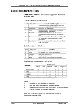


© Copyright 2026