
Broadness to Sea Reach 1 - Port of London Authority
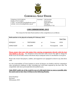
LOWER THAMES AND ESTUARY NAVIGATION Due to the large number of ships arriving and departing the Thames Estuary, recreational vessels should avoid using the Black Deep, Fisherman’s Gat and Princes shipping channels. Instead, you should use: The Middle Deep, the Swin and Warp, or Barrow Deep and Warp when navigating to or from the North; The Horse and Gore and Four Fathom channels when navigating to or from the South; and Foulger’s Gat in preference to Fisherman’s Gat. There are a number of areas in the Lower Thames and Estuary where ships are berthing or boarding or landing pilots. While doing this, ships sometimes make unexpected manoeuvres. For up-to-date information on shipping movements you should maintain a listening watch on the relevant port VHF radio channels and take extra care in the following areas: The Oaze and Warp Medway Approach Channel Coryton and Canvey Island Gravesend Reach Tilburyness and Tilbury Lock Entrance Northfleet Hope Broadness Stoneness Long Reach YANTLET CHANNEL NAVIGATION The Yantlet Channel is marked by gated buoys to provide large vessels with a deep-water channel. You should keep your recreational vessel well clear of the Yantlet Channel and prior to using the crossing routes marked on this guide call ‘London VTS’ to inform them of your intentions, while adhering to the following procedure whenever possible: PORT HEALTH London Port Health Authority is responsible for all public health issues on the tidal Thames. Recreational users are reminded to observer good personal hygiene following contact with water from the river. Inward from the North – Keep close to the starboard-hand buoys and beacons as you come up the river. At the West Leigh Middle Buoy, cross to the south side of the Yantlet Channel, having first made sure that the fairway is clear. Make for East Blyth Buoy before turning onto the inward track. There is safe water for small vessels to the south of the Mid Blyth, West Blyth, and Lower Hope Buoys. Remember outbound vessels will pass close to the port hand buoys as you continue on the south of the channel. When it is safe, cross back to the starboard side of the river in Lower Hope Reach as quickly as possible. Outward to the North – As above in reverse, but crossing to the north between Sea Reach No. 4 and 5 buoys. Inward from the South – Keep to the south of the Yantlet Channel well clear of the deepwater route, crossing to the north side in the Lower Hope as described above. Water Skiing SEARCH AND RESCUE COORDINATION General guidance for all watersport activities: The authorised areas for water-skiing are: HM Coastguard you must wear a lifejacket or appropriate buoyancy aid at all times; you should hold adequate third party insurance cover against accidents, injury, damage etc; you should undertake training courses appropriate to your watersport before taking to the water; you should join a recognised club or association for the activity; and you should make yourself as visible as possible and should utilise “Hi Vis” clothing as appropriate. YANTLET SECONDARY CHANNELS Tidal Barrier Knot Speed Limit when specified vessels are berthed as broadcast by London VTS Grays Terminals 1 & 2 13 Thurrock Black Shelf Yacht Club White Hart 20 ea rt No St. C lem en Broadness Point Lt. et hfle Clements Northfleet Hope Container Terminal Hall's Northfleet p Ho e Tower Tilburyness (see note) Port Of Tilbury Vessel London Traffic Cruise Warning Terminal Tilburyness Light Tilbury Power Station Robins Wharf 22 Ferry Northfleet Lt. Northfleet Thames Terminal Mud Groyne Shingle Shingle Mean High Wate Works Crane Tank Gordon Promenade Works dG Floo Sailing Club House El Sub Sta Cns ate ML W 4.9m 4.6m ing Sw 5.2m Cns Gravesend Reach Pilot Landing Point RNLI Lifeboat Station -B 16 Town Pier & Pontoon Mooring Buoys Port Control Centre 14/15 14 Gravesend Embankment Marina Gravesend Tel: 01474 535700 Embankment Marina & Sailing Club www.theembankmentmarina.net Red Lion Wharf Coalhouse Point Ovens n es Groy 24 PLA Marine Services ge Moorin g Posts 4.9m PH Gravesend Embankment Marina 15 Gravesend Sailing Club Tel: 07538 326623 (Clubhouse) Tel: 07506 367699 (Duty Officer) www.gravesendsailingclub.co.uk 34 28 ch op eR ea Small Vessel Crossing Point Phoenix Unit d Track fo Shoebury Beacon Buoyage Subject to Change W. Shoebury r Yachts Sea Reach No 1 N Sea Reach No 5 S Sea Reach No 4 N Yantlet Flats es Sea Reach No 3 N 44 42 Sea Reach No 1 S Sea Reach No 4 S 40 Sea Reach No 2 S Pilot Landing Point Sea Reach No 3 S Ya cht Reco s tr mm ans en itin ded gT hamTrack es /M e Medway dw ay Mid Swatch No.1 Allhallows Estate River users should not cause damage to the environment or disturb the wildlife of the Thames. The PLA and partners sets out how to behave responsibly around wildlife and these are available on the PLA website. There is also lots of information available on what kind of wildlife you might expect to see. 1 Environmental best practice, including pollution and discharge of sewage is regulated by the PLA, including within the PLA Byelaws. Visit www.met.police.uk/marine VHF REQUIREMENTS Barton's Point Isle of Sheppey Sailing Club 7 Sheerness Pier Sheerness PEEL PORTS (MEDWAY) Large vessels have little room to manoeuvre in narrow channels Police forces and partner agencies along the Thames are working together to reduce crime in the marine environment. Y W Cant Garrison Point All mariners are reminded that they must not leave litter or pour polluting matter into the river. Take what you came with and dispose of it appropriately on land. 1 Y Y Grain Hard Due to their size, ships in narrow channels may not have room to take avoiding action. You should not underestimate the speed of ships and, if near large vessels, you should ensure that you stay well clear and take effective evasive action, ensuring you obey the COLREGS. Have you registered? Y Y Grain Edge ENVIRONMENTAL AWARENESS www.pla.co.uk Y Y Higham Printed by FT Print, Hertford, (PLA March 2015) SS Montgomery VHF CHANNEL 74 CALL SIGN MEDWAY VTS Riv Lim er it o Me f dw ay Project Kraken MARINE WATCH Y Nore Swatch London Stone Grain Spit Intertidal Protected Habitats – a large part of the estuary is included within statutorily designated wildlife sites, and supports nationally and internationally important habitats and species (notably birds, but also including fish, invertebrates and marine mammals). Further details are available at www.pla.co.uk/environment. Pilot Boarding Point No.2 A small craft cannot always be seen from a ship’s bridge, this ‘blind arc’ can be up to one mile ahead and half a mile on either side of the bow. If you cannot see the bridge, the bridge cannot see you and the ships will not be able to take avoiding action. Tilbury Pilot Landing Point Sea Reach No 2 N 38 LOWER THAMES NAVIGATION Cliffe Tanker Warning Light E W 36 Sea Reach No 6 S ts Fla There are traffic warning lights at Cliffe and Canvey Island. When flashing, these indicate that large vessels are manoeuvring in this area. A further light at Tilbury gives advanced warning of large ship movements in and out of Tilbury Lock or manoeuvring/turning in Northfleet Hope bound to/from nearby berths. When these lights are activated, you should reduce speed if necessary and keep clear of large manoeuvring vessels. Shornmead Lt. 16 Gravesend Town Pier & Mooring Buoys Telephone: 01474 337600 www.gogravesham.co.uk/see-and-do/ Gravesend_Pontoon.aspx VHF CHANNEL 69 CALL SIGN LONDON VTS Sea Reach No 5 N Yacht Club Ltd Mucking No5 ck Posts Canal Basin Blacktail Spit 1 Allhallows Works Mooring C Car P ark Sea Reach No 6 N St. Mary's Bay TRAFFIC WARNING LIGHTS l Lo MP ded Inboun ng Lower Hope Point Works Cn Tida y Winch Recommen Blyth Sands rid Slipwa MP Cn MP Cp Mooring Post West Shoeburyness PWC Launching Point W. Nore Sand Egypt Bay The PLA does not permit swimming in the tidal Thames. Swimmers face danger from powerful currents, undertows, underwater obstructions, deep mud, and passing vessels. Swimming also presents a hazard to other river users by impeding the navigation of vessels, especially near bridges, piers, barriers, etc. Please see Thames Byelaw 21. S Small Vessel Crossing Point Diver Denton Wharf Y Leigh Deposit for Alpha Jetty yn Gro W. Leigh Middle Mucking No 1 Lower Hope Refuelling Point SWIMMING Royal National Lifeboat Institution (RNLI) E Blyth Mucking No 3 Mileage Marker from London Bridge 40 Advertisement Location RNLI Lifeboat Station Recommended Outbound Track for Yachts Mucking No7 Inward and outward bound vessels rounding Tilburyness should be aware of strong tidal sets and the presence of vessels manoeuvring at and swinging for berths in the area, including Tilbury Lock. Small Vessel Crossing Point Yantlet Secondary Channel Blyth Sands 1 - please see accompanying text for further information Southend Outfall N W. Blyth 3 Chapman Sands Yacht Club 10 Queenborough Yacht Club Tel: 01268 682643 Tel: 01795 663955 http://homepages.rya-online.net/ 4 Essex Yacht Club queenboroughyc/ Tel: 01702 478404 www.essexyachtclub.co.uk 11 Southend Marine Activities Centre Tel: 01702 612770 5 Holehaven Creek www.southend.gov.uk Tel: 01474 562462 www.pla.co.uk 12 Thorpe Bay Yacht Club Tel: 01702 587563 6 Island Yacht Club www.tbyc.org Tel: 01268 510360 www.islandyachtclub.org.uk 13 Thurrock Yacht Club Tel: 01375 373720 7 Isle of Sheppey Sailing Club www.thurrockyachtclub.org Tel: 01795 663052 www.iossc.org.uk Safe Water Sphere Buoy RW S. Shoebury Mid Blyth Tilburyness Warning Broadness Buoy ts R k Tilbury Grain Terminal ch Southend Pier s Sea Reach No 7 N Sea Reach No 7 S Pilot Landing/ Boarding Point N Y Chapman Anchorage Yantlet Channel Yellow Pillar Buoy Vessel Recreation Area er H PLA Harbour Master (Upper District) Pinnacle House, 23-26 St Dunstan's Hill, London, EC3R 8HN Telephone: 0207 743 7909 a nd Cliffe Fleet Low Richmond Lock VHF Channel: 80 Telephone: 020 8940 0634 Leigh 26 PLA Harbour Master (Lower District) London River House, Gravesend, Kent, DA12 2BG Telephone: 01474 562211 9 Leigh-on-Sea Sailing Club Tel: 01702 476788 www.leighsailingclub.org 32 Tanker 30 cki East of Canvey Island VHF Channels: 16 & 67 Call Sign: ‘Thames Coastguard’ Telephone: 01255 675518 2 Benfleet Yacht Club Tel: 01268 792278 www.benfleetyachtclub.org pm a nS Yantlet Secondary Channel Sea Reach Mu HM Coastguard VHF Channels: 16 & 67 West of Canvey Island ‘London Coastguard’ Call sign: ‘London Coastguard’ Telephone: 0208 3127380 a Ch LONDON GATEWAY PORT Danger Area (East of Sea Reach No.4) Yacht Club Scars Elbow ‘S’ Jetty CONTACTS London VTS: Call Sign: ‘London VTS’ Crayfordness to Seaward Limit VHF Working Channels: 68 & 69 Telephone: 01474 560311 Teddington to Crayfordness VHF Working Channel: 14 Telephone: 0208 855 0315 CORYTON Chainrock 8 Leigh Motor Boat Club Tel: 01702 714858 www.leighmotorboatclub.com 12 Thorpe Bay VHF CHANNEL 68 CALL SIGN LONDON VTS Leighbeck Point 3 Chapman Sands Holehaven Pier Oikos Tanker Traffic Storage Warning Light Calor Gas Speed Limit in Holehaven Creek YACHT CLUB & MARINA INFORMATION 1 Allhallows Yacht Club Ltd Tel: 01634 270788 www.allhallowsyachtclub.net V e s se l Recreational Area Yacht Club Knot Safe Water Pillar Buoy If your vessel is in distress and needs immediate assistance, you can use distress flares, rockets, smoke floats and other recognised international distress signals. Yacht Club (West of Sea Reach No.4) 6 Island Knot Slipway/Causeway SShoeburyness hoeburyness IInner nner FFiring iring D anger AArea re a Danger Southend Flats Canvey Creek Hole Haven Broadness to Sea Reach 11 Southend Marine Activities Centre Two Tree Island Tidal Barrier Canvey Island Estate dialling 999 and asking for “Coastguard” ; broadcasting a “MAYDAY” or “PAN-PAN” call on VHF Channel 16 or the London VTS channel for the area you are in; or calling Thames Coastguard, London Coastguard or Thames Barrier Navigation Centre (London VTS). Distress Signals Erith Rands Mucking Flats Blyth Sands/All Hallows Southend Pier to Canvey Island (Thorney Bay) Remember - sail boards are subject to the same byelaws and collision regulations as any other small vessel. Leigh Sands Hadleigh Ray River Thames Recreational Users Guide - NOT FOR NAVIGATION - North Cardinal Buoy Flashing Light Note: VHF Digital Selective Calling (DSC) alert on Channel 70 is not available at London Coastguard. Westward of Putney Bridge; and Areas clear of the navigable channel and approaches to commercial berths in: Speed Limit Southend inshore area 5 Holehaven Speed Limit The Thames Estuary Yacht Club Speed Limit in East Haven Creek Tidal Barrier Sailing Club 4 Essex Old Town Yacht Club Knot Speed Limit in Benfleet Creek Port Buoy South Cardinal Buoy There are RNLI lifeboat stations at Teddington, Chiswick, Lifeboat Pier Waterloo Bridge, Gravesend, Southend-on-Sea, Sheerness, Whitstable, Burnham, Walton-on-Naze and Harwich. In an emergency, RNLI lifeboats are coordinated by the Coastguard. Boat Club 2 Benfleet The tidal Thames is extremely hazardous for wind surfers. You should therefore restrict this activity to the following areas: 1. 2. 3. 4. Yacht Clubs/Marinas Beacon If you get into difficulty (or see or hear anyone in distress) call for help by either: Wind Surfing Starboard Buoy Emergency Communications A lifebuoy or other means of preserving life is on board; At least one other person is aboard and able to take charge of the vessel or to give assistance during the towing; and There are always two ‘look-outs’ on the towing boat, one to control and watch the boat and one to watch the participant. 9 Leigh-on-Sea 8 Leigh Motor Knot If you are in charge of a craft towing water skiers (or people involved in similar activities), you must ensure: Key: London Coastguard is based at the Thames Barrier Navigation Centre (London VTS). It is responsible for coordinating all maritime search and rescue (SAR) incidents on the tidal Thames between Canvey Island (Holehaven Creek) and Teddington. SAR activity coordination to the east of Canvey Island, whilst coordinated by Thames Coastguard, will after June 2015 be managed locally from Dover Coastguard Operations Centre or remotely from the National Maritime Operations Centre in Hampshire. London Coastguard will be supported by the National Maritime Operations Centre from December 2015. Water skiers must keep well clear of the Fobbing and Easthaven tidal barriers and their boat must manoeuvre at a slow speed appropriate to the local conditions when going to or from the authorised areas. Wat Tyler Country Park West Shoebury Beach Hoo Peninsula If you are a PWC user, you must manoeuvre at a slow speed and obey the 8 knot speed limit in the creeks when proceeding to or from the authorised PWC areas through the designated access routes. For further information please refer to the Code of Conduct for use of Personal Water Craft on the Thames Estuary which is available to download from our website. Whilst Rabies controls have changed due to the “Passport for Pets” scheme, the presence of any animals on board vessels must be reported to Port Health and the animals must be kept properly secured on board at all times. Telephone: 01474 363033 or visit: www.cityoflondon.gov.uk/porthealth Marsh End Sands – Launch at Two Tree Island Causeway Tewkes Creek – Launch at Two Tree Island Causeway Holehaven Creek – Launch at Pitsea Hall County Park Personal Water Craft (PWC) – i.e. jet skis, jet bikes, water-skiing, aquaplaning, and parakiting – are not permitted in a fairway or within 200 metres of any public beach, bathing place, residential property, wharf or jetty on the tidal Thames. The only authorised launch points are marked on the guide at: Recreational users are advised to maintain a listening watch on the appropriate London VTS sector VHF channel - VHF Ch 68 or Ch 69 (as appropriate). Yacht Club 1. 2. 3. Personal Water Craft Recreational users are reminded that commercial vessels not constrained by their draught will be using these Secondary Channels both inward and outward bound. Recreational users should therefore, in compliance with Rule 9 of the International Regulations for Preventing Collisions at Sea, keep as far to the starboard side of the river which lies on their starboard side as is safe and practical. Recreational users are also reminded of the obligation within Rule 9 placed on vessels of less than 20m in length, sailing vessels or fishing vessels not to impede the passage of vessels which can safely navigate only within a narrow channel or fairway. Pitsea Marina WATERSPORTS Primary VHF Working Channel: 74 Other Working Channels: 16 and 22 Call sign: 'Medway VTS’ Telephone: 01795 663025 Radar Coverage: River Medway and approaches (Medway buoy inwards) 10 Queenborough Yacht Club The Port of London Authority (PLA) would strongly advise all recreational river users to carry and use a VHF radio, maintaining a continuous listening watch to London VTS at all times. It should be noted that if your vessel is over 13.7m (45ft)* you must carry a VHF radio capable of communicating with the PLA’s Vessel Traffic Service (VTS) Centres. In addition to carrying a VHF, vessels over 40m in length or 50 gross tons must report their arrival, departure and passage through the port at the designated reporting points (these are marked on Thames charts). If your vessel is over 13.7m (45ft), you must maintain a continuous listening watch on the VHF channel appropriate to the part of the Thames you are in (see London Vessel Traffic Services section). Except in emergencies, the person operating the VHF should be trained and qualified or be under the supervision of a qualified person. The PLA also recommends you carry a well-charged mobile phone whenever you are afloat, although this should not be regarded as a substitute for marine VHF. * A special exemption is in place for Narrow boats (please see “VHF and Narrow Boats”), Recreational vessels and vessels under oars. Please see General Direction 4. LONDON VESSEL TRAFFIC SERVICES The PLA VTS centres at Gravesend and Woolwich monitor vessel traffic movements on the Thames. They operate 24 hours a day and broadcast navigational information and advice every half-hour. Be aware that VHF radio conversations, telephone calls, CCTV and radar images are recorded in both VTS centres. London VTS VHF channels are as follows: Channel 69 (from the seaward limit to Sea Reach No. 4 Buoy) Navigational broadcasts are made at 15 minutes and 45 minutes past each hour. Channel 68 (from Sea Reach No 4 Buoy to Crayfordness) Navigational broadcasts are made on the hour and at 30 minutes past each hour. Channel 14 (from Crayfordness to Teddington) - Navigational broadcasts are made at 15 minutes and 45 minutes past each hour.


© Copyright 2026