
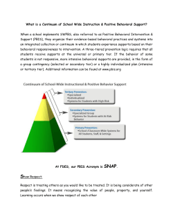
SNAP Estimated Areas of Control as of 30 April, 2015
SNAP
Estimated Areas of Control as of 30 April, 2015
Damascus
Sources: SOHR conflict incident data; previous AoC maps by SNAP, HIU; Populated areas layer from Oak Ridge National Laboatories Land Scan, 2013; Border crossings from OCHA 24 April 2015
and SNAP country analysts.
Disclaimer: White color represents areas that were little- or un-populated as of 2013. Conflict incidents in the outskirts of Qalamoun do not appear on the map because they take place outside
the Syrian borders.The boundaries and names shown and the designations used on this map do not imply official endorsement or acceptance by SNAP.
Creation date: 20 May 2015
SNAP Estimated Areas of Control Map
April 2015
This map is intended to provide humanitarian actors with a regularly-updated
picture of which groups control territory in Syria, in order to facilitate an
estimation of the obstacles that may be faced in program operations. Due to the
limitations of available data, it is not comprehensive, and should be used to
complement, not replace, information from the field.
Methodology
The primary source for this map is a database of conflict incidents as recorded by
the Syrian Observatory for Human Rights (SOHR). For each incident, SOHR’s
network reports which group is currently controlling the affected territory.
SNAP maps these incidents to create a general impression of the latest
developments in conflict areas. For every location, the group that was in control
at the time of the latest incident in the reporting is taken to be the controlling
party for mapping purposes. To generalize from points to areas of control, SNAP
makes a best estimate based on secondary data (media reports, etc.), the
availability of roads and other terrain features, and on information provided by
SNAP’s Syria analyst, from private interviews (PIs). Areas described by SOHR as
“contested” are marked with red dots. As a baseline and cross-check, SNAP uses
previous areas of control maps, including its own, those by the US State
Department’s Humanitarian Intelligence Unit, and other maps not currently
published.
The final areas of control (colors) are overlaid onto a LandScan population
density layer (colored vs. white areas) to more accurately represent the scope of
populated territory controlled. Previous maps have tried to show areas under
control of Jabhat Nusra, however this has been excluded from the current map
due to the severity of the limitations in tracking control among multiple armed
opposition groups (AOGs).
The conflict density shown in the insert is also derived from SOHR data.
Limitations
While this map can provide a dynamic impression of how the control of territory
changes, it is only an estimate. In an information-poor environment, SOHR
provides some of the broadest coverage and best access available, but it is still a
single source, which carries limitations of its own, including potential for bias.
While SOHR reports a significant number of conflict incidents, their coverage is
unlikely to be comprehensive. A comparison with other datasets suggests that
SOHR coverage is stronger in urban areas than rural ones, and covers Aleppo,
Rural Damascus and Dar’a governorates more thoroughly than others.
Furthermore, SOHR data may not include changes of control that are not
conflictual, for example, truce agreement, withdrawals, or political agreements
between AOGs.
The extrapolation of territorial areas of control from a limited set of incidents,
and general situational awareness, also introduces the possibility for error.
Previous SNAP maps, which are used as a baseline and cross-check, were based
solely on the situational awareness of a SNAP Syria analyst via PIs, and may be
distorted due to limitations or inherent biases in that network.
The inability to clearly distinguish between the territory held by various AOGs is
a shortcoming of all currently available control maps.
There is a lack of updated population density information for Syria, even for the
pre-crisis period. The population density layer used is from 2013, but because it
is based on the presence of structures, it may not account for the changes in
population resulting from the displacement of more than half of Syria’s pre-war
population. In addition, significant locations that are not per se “populated areas”
such as oil wells, power plants, and water treatment facilities, may not be appear
on this map.


© Copyright 2026