
Moelfre Walk.indd
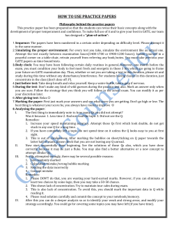
bbc.co.uk/weathermanwalking
© 2015
Weatherman Walking
Moelfre
Approximate distance: 4.68miles
For this walk we’ve included OS grid references
should you wish to use them.
4
5
3
1
6
2
Start End
7
8
N
W
E
S
Reproduced by permission of Ordnance Survey on behalf of HMSO. © Crown copyright and database right 2009.All rights reserved. Ordnance Survey Licence number 100019855
The Weatherman Walking maps are intended as a guide to help you walk the route. We recommend using an OS map of the area in conjunction with this guide. Routes and conditions may have
changed since this guide was written. The BBC takes no responsibility for any accident or injury that may occur while following the route. Always wear appropriate clothing and footwear and check
weather conditions before heading out.
1
bbc.co.uk/weathermanwalking
Weatherman Walking
© 2015
Moelfre
Start: Village centre car park next to Porth Moelfre
Starting ref: SH 5122 8632
Distance: 4.68 miles
Grade: Easy / Moderate
Walk time : 2 hours (2.5 hours including stops)
This walk on Anglesey has a bit of everything, from famous lifeboatmen to mysterious standing stones. For part of
the way the route follows a section of coast known as the ‘shipwreck coast’, due to the numerous wrecks that
have taken place in its treacherous waters and which inspired something very close to Derek’s heart – weather
forecasting!
The coastal path is well-trodden and signposted. A section of quiet country road then leads away from the
coast before paths through fields take you back to Moelfre.
1
Moelfre Village
Moelfre is a picturesque village with spectacular beaches, a working lifeboat and a fascinating
history. Translating as ‘barren hill’, Moelfre was a focal point for a sea battle in 1157 between Anglesey
seamen and Henry II’s fleet, but it was during the 19th century that the village really expanded as a
maritime hub. On a clear day you can see the Great Orme 14 miles away!
Looking back from the coastal path
towards Moelfre village and beach
2
bbc.co.uk/weathermanwalking
Weatherman Walking
© 2015
Moelfre
Directions
From the car park, walk up the hill and turn right onto the coastal footpath. A short distance around the
headland, the path leads past the original 19th century lifeboat station and slipway to reach the statue of
Dic Evans in front of the RNLI visitor centre.
Derek and walking guide Bedwyr set
off up the hill towards the coast path
2
Dic Evans statue (SH 5153 8653)
Dic Evans was a member of the Moelfre lifeboat who was awarded not one RNLI gold award but two
- as well as an MBE! The first was for his role in the rescue of the Hindlea crew in 1959 and the second
came when Dic was 61 and involved in the rescue of the crew of the Greek ship Nafsiporos, along
with his son, David. Serving with the lifeboat was a family tradition, with Dic’s father, grandfathers and
an uncle also crewmen before him.
Dic died in 2001 and this 14ft statue, by sculptor Sam Holland, was unveiled by Prince Charles in 2004.
The statue stands outside the RNLI-run Seawatch Centre, which tells the story of Moelfre and includes
an RNLI shop.
Derek and Bedwyr meet lifeboat
operations manager Rod Pace
Moelfre’s first lifeboat station was built in the 1830s and, since then, its crew has saved more than 1,000
lives. During the time of Derek’s visit, the existing lifeboat station, built in 1909, was being demolished
and a new station built in its place.
Also near the Seawatch Centre is
a memorial sculpture to the Royal
Charter shipwreck
3
bbc.co.uk/weathermanwalking
© 2015
Weatherman Walking
Moelfre
A little further along the coastal path is Moelfre’s new lifeboat station. During its construction in 2014, there
was a well-signposted diversion from the coastal path, alongside the RNLI shop and through the car park
to the road, before returning, via a couple of right turns, to the coastal path near a row of whitewashed
cottages.
The closed section of coast path was due to reopen in January 2015, bringing walkers past the brand new
lifeboat station and leading to the beach by the row of whitewashed cottages, described above.
The coast path past the lifeboat station
was due to reopen early in 2015
3
The Swnt (SH 5165 8684)
The Swnt is a narrow channel between Anglesey and Ynys Moelfre, a small island which is home to
many sea birds. If you’re lucky, you might see a porpoise or two swimming in the bay!
Derek and Bedwyr admire the views
across Y Swnt
Continue along the coastal path for about 200 yards to reach a memorial plaque and bench at the end of the small promontory.
4
bbc.co.uk/weathermanwalking
Weatherman Walking
4
© 2015
Moelfre
The Hindlea Seat (SH 5157 8688)
This stone memorial commemorates the heroic rescue of the entire crew of a steamer called the
Hindlea, which got caught in a storm on October 27 1959. She moved to sheltered waters off Moelfre
but it was still a very dangerous position for the crew and the lifeboat, with hurricane-force winds of up
to 104mph. The lifeboat crew, including Dic Evans, managed to save all eight crew members by using
the huge waves to bring the lifeboat level with the steamer eight times and jumping from deck to
deck to rescue the men one at a time.
At low tide the remains of the Hindlea can still be seen on the rocks below, a short distance along the
coast path from the memorial. Strangely, the Hindlea was wrecked 100 years to the very night that
another ship called the Royal Charter was wrecked at Moelfre. Unfortunately, the outcome for those
aboard was far worse, as we’ll discover next.
Derek stops at the Hindlea Seat to
find out about the heroic efforts of the
lifeboat crew in 1959
Continue along the well-trodden coastal path, passing through a kissing gate to a small caravan site. Make
sure you stop to read the large information board as it has interesting details about this section of coastline!
After a further 250 yards, a sign on the left of the path points to a short detour over a stone stile to get to the
Royal Charter monument.
The stone stile and a short detour lead
to the Royal Charter memorial
5
bbc.co.uk/weathermanwalking
© 2015
Weatherman Walking
5
Moelfre
Royal Charter Memorial (SH 5096 8692)
This memorial overlooks the spot where the Royal Charter ran aground and pre-dates the commemorative
statue we passed earlier at the Sealife Centre, which was unveiled in 2009 to mark the shipwreck’s 150th
anniversary.
The Royal Charter was carrying gold from South Africa to Liverpool when it got caught in a terrible storm
on the night of October 26 1859 - a night when many other ships were also wrecked. Just 41 of the 452
passengers survived, and this was mainly due to the efforts of Moelfre men who made a human chain into
the sea to rescue them. Many of those who died were weighed down by heavy clothes and the gold they
were carrying in their pockets.
Bedwyr points to the spot the Royal
Charter ran aground in a terrible storm
Legend has it that Moelfre became rich that night, with many of its houses supposedly being built with the gold from the wreck, which was
washed ashore in the following weeks. Villagers were criticised in the press but an account by Charles Dickens, who visited Moelfre following the
tragedy, was sympathetic towards them and paid tribute to the rector, who comforted relatives and buried scores of bodies. Almost 150 were
buried in Llanallgo churchyard, whilst many other graves can be found in churchyards along the Anglesey coast.
The wreck site is still popular amongst divers, who have found many personal items including women’s brass suspenders, a child’s shoe, chess
pieces and bottles of wine.
Retrace your steps from the memorial and continue along the coastal path, skirting around the back of a house overlooking the delightful small bay of
Porth Forllwyd.
Bear right at the entrance to the neighbouring property and skirt around the back of the bay to reach the section of path overlooking the wide expanse
of Traeth Lligwy beach (SH 4958 8712). This leads to the car park and toilet block, which get very busy during the summer months!
Skirting around the house which
overlooks Porth Forllwyd
Traeth Lligwy beach
Information boards near Traeth Lligwy
car park
6
bbc.co.uk/weathermanwalking
© 2015
Weatherman Walking
Moelfre
From the car park at Traeth Lligwy, turn inland and follow the road.
After a quarter of a mile, go straight across at the crossroads and
walk another mile along or so until you reach a kissing gate with an
information board on the right.
Go through the gate, down a short flight of steps and bear right across
the field to reach the old chapel clearly visible straight ahead.
Derek and Bedwyr approach Hen
Gapel Lligwy
6
The kissing gate leading to the old
chapel and Din Lligwy hut circle
Hen Gapel Lligwy (SH 4973 8646)
Hen Gapel Lligwy – the old chapel - is one of three sites in the Lligwy settlement, all from different
periods of history and managed by Cadw. The oldest part of the chapel, now an atmospheric ruin,
was built in the 12th century, at a time when an increase in Viking raids led to many wooden churches
being replaced with stone buildings. The small chapel to the side, with the crypt underneath, was a
16th century addition.
Hen Gapel Lligwy is now a landmark ruin
with spectacular views across the bay
From the doorway of the old chapel, bear right, across the field, and join the path that leads from the roadside kissing gate. Head for another kissing
gate at the right hand side of the small woodland ahead. The obvious path up through the woods leads to a clearing and the site of the hut circle.
7
bbc.co.uk/weathermanwalking
© 2015
Weatherman Walking
7
Moelfre
Din Lligwy (SH 4964 8614)
This impressive site is an ancient fortified settlement dating back
to the Iron Age and later used by the Romans. A glass jug, pottery
shards and a silver ingot have been found here, as well as evidence
of iron smelting and iron-working in workshops, fired by coal thought
to be imported by boat from Conwy.
A wall around the settlement is thought to date from the fourth
century, when the Romans’ power was fading and raids were
becoming more common. The village was abandoned 1,600 years
ago, but the foundations and the layout are still very clear and give
an excellent insight into life here.
The layout of Din Lligwy hut circle is
well preserved
Derek learns more about Din Lligwy’s
fascinating history
Derek and Bedwyr are filmed as they
head towards Lligwy burial chamber
Head through the kissing gate for a
prehistoric surprise!
From Din Lligwy, retrace your steps down through the woods, across the
field and back to the road. Turn right and continue along the road for
about 300 yards where, on the right, is a kissing gate, leading to Lligwy
burial chamber.
8
bbc.co.uk/weathermanwalking
Weatherman Walking
8
© 2015
Moelfre
Lligwy burial chamber (SH 5012 8602)
This burial chamber – or cromlech, in Welsh – is from the late Neolithic period and therefore one of the
last of these kinds of tombs. Its capstone weighs 25 tons, leading to some speculation as to how it was
transported here!
Originally, the huge stone would have been covered with earth and a small tunnel would have
led into the chamber. The site was excavated in 1908 and the remains of up to 30 people were
discovered, as well as a beaker and other late Neolithic artefacts.
Bedwyr tells Derek the history of Lligwy
burial chamber
Return to the road and continue for about 700 yards until you reach a metal kissing gate leading into a field on
the left. Follow the right hand field boundary and a stream on the right, until the stream turns away to the right.
From here, head diagonally left across the field to reach another gate into the next field.
Keeping the hedgerow on the left, walk towards the house and outbuildings in the far left hand corner of the field.
Turn right at the outbuildings and follow the concreted access road to the corner, with a driveway to a house on
the right.
Follow the public footpath signpost right, along a short but sometimes muddy path alongside the house to reach
a field. Initially you need to bear right across the field, then head to the left corner, where a hidden pathway
leads through a thicket of small trees. Follow the path to a metal gate, go through it and walk past the end of a
row of houses to reach the road.
Path down through thicket behind
houses
This access road takes you to the main road, where our route turns left, downhill, and back to the starting point at
the village car park.
9


© Copyright 2026