
PolSARpro and Sentinel
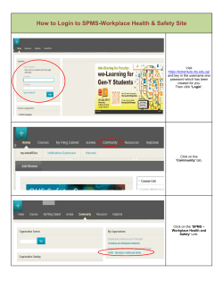
PolSARpro and Sentinel-1 Toolbox
Practical sessions on Tuesday 20 Jan (Day 2): 14:00 – 15:30 and 16:00 – 17:30 (3
hours total)
This exercise uses the following data:
ALOS PALSAR Quad Pol, Level 1.1 (P1.1), acquired over Rome, Italy. This data has been provided by the
European Space Agency.
The data directory is: …\Data\Rome_ALOS
1. Sentinel 1 Toolbox
(processing and visualisation of original data)
1.1. Open the Sentinel-1 Toolbox
1.2. Import original image:
1.2.1. File / Import Raster Data / SAR Data / ALOS PALSAR CEOS (browse to VOL-ALPSRP178810830-P1.1__A)
1.3. View metadata:
1.3.1.
1.3.2.
1.3.3.
1.3.4.
1.3.5.
Expand “Identification” folder
When was the image acquired?
Expand “Metadata folder”, double click “Abstracted_Metadata”
What is the sensor geometry (Asc/Desc, antenna pointing, incidence angle)?
What are the image dimensions, and the range and azimuth spacing?
1.4. View product on world map:
1.4.1.
1.4.2.
1.4.3.
1.4.4.
Click on globe icon, or View / Tool Windows / World Map
View image bands
Expand “Bands” folder, double click on Intensity bands
Experiment with zooming and panning
1.5. Multilook:
1.5.1.
1.5.2.
1.5.3.
1.5.4.
1.5.5.
SAR Processing / Multilooking
View settings in “Processing Parameters” tab. Notice the recognised multilook factor to produce square pixel
Set output folder and filename in “I/O Parameters” tab
Click Run
View the bands of the multilooked image, view RGB image view: View / Open RGB Image View…
1.6. Calibrate:
1.6.1. SAR Processing / Radiometric / Calibrate
1.6.2. Open calibrated image
1.6.3. View pixel values of calibrated image: Select “Pixel Info” tab in top left window, move mouse cursor over
image to view pixel values
1.6.4. Linear to decibel: Select “Products” tab in top left window, right click on band, select “Linear to/from dB”
1.6.5. Open newly created virtual decibel band
1.7. Stretch histogram:
1.7.1. With a viewer open showing a calibrated image in decibels, select “Colour manipulation” tab in lower left
window
1.7.2. select and drag triangular markers along histogram to stretch.
1.8. Compare linear and decibel images in separate viewers:
1.8.1. Close all viewers, keeping only two viewers open containing linear and decibel images of same polarisation.
1.8.2. Select: Window / Tile Evenly
1.8.3. Select “Synchronise compatible product views” and “Synchronise cursor position” icons on the right side of
the Navigation tab (lower left window)
1.8.4. Pan and zoom into the synchronised viewers, compare pixel values.
1.8.5. Repeat the steps above for RGB composites in linear and decibel
1.9. Speckle filter:
1.9.1. SAR Processing / Speckle Filtering / Single Product Speckle Filter
1.9.2. experiment with different filters in the “Filter” dropdown box of the “Processing Parameters” tab
1.10. Terrain correction:
1.10.1.
1.10.2.
1.10.3.
1.10.4.
Select one of your multilooked, calibrated and speckle filtered images
Select SAR Processing / Geometric / Terrain Correction / Range-Doppler Terrain Correction
In the “Processing Parameters” tab, select “DEM” to save the DEM as a new band of the orthorectified image
Select “Run”
1.11. View orthorectified image
1.11.1. View image bands
1.11.2. View DEM band
1.11.3. Import new LUT for DEM visualisation: Select “Import colour palette from text file” icon on the right of the
“Image Manipulation” tab (lower left window). Select a different colour palette. (Can also manually change
LUT by clicking on triangular sliders on histogram: left click to change colour, right click to remove slider)
1.12. Compare image with DEM in same viewer
1.12.1.
1.12.2.
1.12.3.
1.12.4.
1.12.5.
1.12.6.
Open an RGB image of three polarisations
Select the “View layer visibility and transparency” icon in the toolbar
Select the plus icon at the top right of the Layer Manager window
Select “Image of Band / Tie-Point Grid”, then Next
Select the “elevation” band, then Finish
Now, using the transparency slider, or checking/unchecking the check box of the bands, you can compare the
SAR and DEM images in the same viewer
1.13. Export subset to Google Earth
1.13.1. With the RGB SAR image visible in the viewer, and the corresponding image selected in the “Products View”,
select: File / Other Exports / View as Google Earth KMZ
1.13.2. Select an output directory and filename, then “Save”
1.13.3. Double click on KMZ file in Windows Explorer to open it in Google Earth
2. PolSARPro
(polarimetric processing)
2.1. Open PolSARPro from S1 TBX
2.1.1. SAR Processing / Polarimetric / Launch PolSARpro
2.2. Import original image
2.2.1.
2.2.2.
2.2.3.
2.2.4.
2.2.5.
Single Data Set
Environment: Browse to …/Data/Rome_ALOS folder
Select “No” when warning message appears that no data files have been found
Import / Spaceborne Sensors / Alos-1 – Palsar / Data Processing Level 1.1 / Quad Pol / JAXA CEOS Format
In the field “SAR Leader File”, select “LED-ALPSRP178810830-P1.1__A”
2.2.6. Select “Check Files”, and “OK” in notification window about ALOS-PALSAR convention for VH and HV. The
fields for SAR Trailer and SAR Image Files should now be filled automatically
2.2.7. Select “Read Header”, then select “OK”
2.2.8. Select Import / Extract / Full Resolution
2.2.9. Select Multi Look: Row: “6”, Col “1”
2.2.10. Leave default T3 selected as Output Data Format
2.2.11. Select “Run”, and “Yes” to create a T3 directory
2.2.12. After having inspected the Pauli RGB and valid pixel mask images, close the viewers
2.3. Produce Polarimetric Decompositions
2.3.1. Select Process / Polarimetric Decompositions / FRE3 : Freeman 3 Components Decomposition
2.3.2. Select “BMP Target Generators (TgtG)” checkbox, then “Run”
2.3.3. Repeat the last two steps for other decompositions
2.4. Produce Entropy, Anisotropy and Alpha images
2.4.1. Process / H/A/Alpha Decomposition / Decomposition Parameters
2.4.2. Select Entropy, Alpha and Anisotropy and select the BMP check boxes.
2.4.3. Set the “Window Size Row” and “Window Size Col” both to 1, then select “Run”
2.5. Change the polarimetric basis to left/right circular
2.5.1. Process / Elliptical Basis Change / Circular (L / R)
2.5.2. Leave parameters as default and select “Run”
2.6. Convert Coherence Matrix elements to logarithmic scale (decibel)
2.6.1. Process / Matrix Elements
2.6.2. Select 10log(Modulus)
3. Sentinel 1 Toolbox
(processing and visualisation of polarimetric data)
3.1. Import PolSARpro files into Sentinel 1 Toolbox
3.1.1. In S1TBX, select: File / Import Raster Data / SAR Data / PolSARPro
3.1.2. Browse to one of the .hdr files in one of the T3 folders generated by PolSARpro, then select “Import Product”
3.2. Visualise and compare the PolSARpro product bands with RGB composites and overlays
3.3. Replace metadata of polarimetric product with corresponding S1TBX processed product
3.3.1.
3.3.2.
3.3.3.
3.3.4.
Select the polarimetric product in the “Products View” window (upper left)
Utilities / Metadata / Replace Metadata
In the dropdown box, select the product multilooked in S1TBX, then select “OK”
Save the product with the metadata replaced as a BEAM DIMAP product: either select the Save icon (top
toolbar) or File / Save Product
3.3.5. Select “Yes” to convert to BEAM-DIMAP format
3.4. Orthorectification of PolSARpro product
3.4.1. Repeat steps 1.10 and 1.13 for the PolSARpro product to orthorectify it and export various visualisations to
Google Earth.
3.5. Export to Geotiff
3.5.1.
3.5.2.
3.5.3.
3.5.4.
3.5.5.
Select the Terrain Corrected product in the Products View window (top left)
File / Export Raster Data / GeoTIFF
Select an output filename and location
Select Subset if you would like to save only a subset
Select “Export Product”
3.6. Repeat for other PolSARpro files
3.6.1. Repeat the steps above to import and postprocess the other PolSARpro files. Interpret the results.
3.6.2. Return to PolSARpro to produce other polarimetric datasets, then analyse them in S1TBX.


© Copyright 2026