
Experiences of Successful Partnering
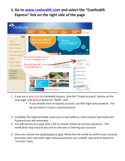
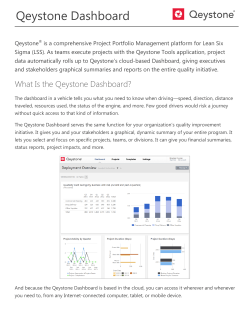
The Climate Resilience Toolkit and the Water Utility and Planning Communities: Experiences of Successful Partnering Nancy Beller-Simms, Ph.D. Program Manager, NOAA CPO, Sectoral Applications Research Program CPASW - Las Cruces, New Mexico March 24, 2015 This talk is based on experiences with building the water sector of the Climate Resilience Toolkit Some Background: •Climate Resilience Toolkit – Water Sector •Extreme Events Study •Extreme Precipitation Dashboard First Thoughts on Developing Partners Partnerships are serendipity; they depend upon: showing up, listening, observing, challenging, and caring. They are cultivated – not developed over night. For large scale activities (e.g., this toolkit) – scale, geography, draw and influence matter. Personal relationships also matter. Current Partners for the “Dashboard” • American Planning Association (APA): James Schwab • American Water Works Association (AWWA): Adam Carpenter • Association of Metropolitan Water Agencies (AMWA): Erica Brown • Water Environment Federation (WEF): Claudio Ternieden • Water Environment Research Foundation (WERF): Katy Lackey • Water Research Foundation (WRF): Kenan Ozekin Good Partnerships • evolve with: substance, people, and goals. • result from acceptance of differing views as everyone interprets the world differently Developing the Extreme Events Dashboard General Approach: • Meet regularly. • Agree upon goals. • Re-evaluate goals. Specific Approach: • Better understand population. • Develop survey. • Identify most relevant constituents (avoided member fatigue) for inclusion in survey. The Survey Survey Statistics and Participants Online for 2 weeks, 11 multi-layered questions Sent to 745 people Institution Date Sent Target Group AMWA 16-Oct Sustainability Committee 56 APA 16-Oct Hazard Mitigation & Disaster Recovery Interest Group 250 AWWA 20-Oct Climate Change Committee 150 WERF 15-Oct Climate Change Listserv 264 WRF (WaterRF) 15-Oct Selected group w/CC interest 25 TOTAL # of Participants 745 66 responses 10 thrown out = 56 TOTAL 34 completed ALL questions Slides liberally “borrowed” from: Katy Lackey, Water Environmental Research Foundations What institutions were participants from? Water supply/distribution Local government Wastewater collection Other Stormwater manager Planning agency Watershed/river commission State government Federal agency Academic Institution 0% 10% 20% 30% 40% 50% Percent belonging to institution 60% Use of Climate Information Frequent (50%+) 1. Understanding risk for water supply 2. Infrastructure/capital investments 3. Operational purposes Frequent/Occasional (50%+) 4. Prepare hazard mitigation/climate adaptation 5. Develop impact reports & risk assessments 6. Plan extreme events 7. Plan explicit forecast 8. Plan emergency/long-term response 9. Other purposes Don’t Use/May in Future (50%+) 10. Rebuilding following an extreme event Sources, Scales, Types and Forms Where do you obtain climate/weather data? 90% 80% 70% 60% 50% 40% 30% 20% 10% 0% 84% 58% 53% 49% 49% NWS, NCDC, NOAA Northwest RISA 27% 4% Source of information Universities, local emergency management, blogs Using the survey results, we brought scientists and representatives from the foundations together to discuss what would be practical in a dashboard. We are currently developing the dashboard. We anticipate that it will include data sets for: • climate stressors (e.g., monthly normals & extremes); • people and assets (e.g., soil moisture index, vulnerability index) • forecasts (e.g., 6-10 day precip and temp). Next Steps • Dashboard • Climate Resilience Toolkit • Educational Activities (combining with new partners) • Teacher inclusion in CRT case studies Successful Partnerships 1. are serendipity; they depend upon: showing up, listening, observing, challenging, and caring. 2. evolve with: substance, people, and goals. 3. result from acceptance of differing views as everyone interprets the world differently 4. combine viewpoints which often result in practical, cutting edge, and innovative solutions Thank you! More Information: Nancy Beller-Simms [email protected] 301-734-1205 Next Steps: Barriers & Tools Lack of training/education is primary barrier (50%) 1. 2. 3. 4. Managing/processing data Understanding/interpretation non-climate professional Modeling skills Downsizing forecasts to local scale *Other barriers: access, local skepticism Use of Climate Info 71% currently use for planning purposes Of the 29% that do not: 38% plan to use in the future 44% might use in the future Reasons for Not Using Climate Info Institutional support/capacity Uncertainty in CC/impacts Other Next Steps: Barriers and Tools 63% say data needs will change in future: Changing Needs Refine & update Access Short-term needs Long-term needs Needed formats vary data maps, GeoTiff, KML among most popular Next Steps: Barriers & Tools Future products or tools: Adjustments / updates to existing tools Precipitation data to assist design All data in one place Economic impact indicator Timeframe assessment for climate change No new tools, just better access Sources, Scales, Types and Forms Level of Need Time Scales Most critical Foresee Not Helpful critical at critical in future present Planning Purpose (most common identified) Minutes to hours 37% 17% 39% 7% Immediate response (54%) Hours to a day 37% 34% 24% 5% Short-term (39%) A day to several days 33% 50% 10% 8% Short-term (49%) Days to weeks 20% 61% 15% 5% Medium (39%) Weeks to months 15% 66% 15% 5% Medium (56%) Months to years (seasonal) 24% 60% 12% 5% Long-term (55%) Years to decades 18% 58% 18% 8% Long-term (84%) Decades to centuries 3% 45% 50% 3% Long-term (64%)


© Copyright 2026